Welcome to Classical Images!
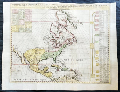
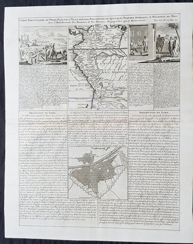
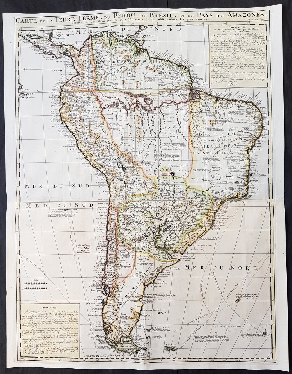
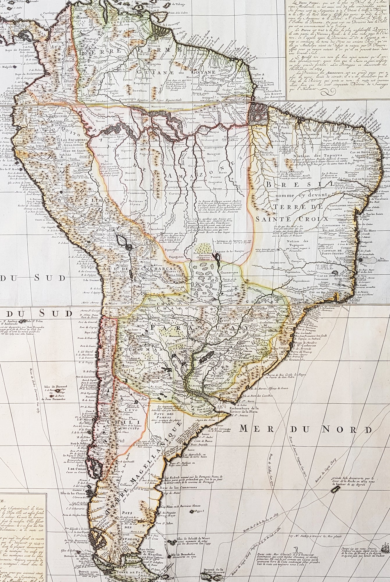
Description: This large, scarce, highly detailed & beautifully hand coloured original antique map of South America was published by Henri Abraham Chatelain in the 1719 edition of Atlas Historique.
Background: This map was engraved with Chatelain's usual eye for detail, with all the known information available at the time of publication. Old known highly detailed coastal information is included along with much speculative detail of the interior and the river systems of the Amazon and River Plate. In the southern part of the are the tracks of the exploration routes of explorers such as Magellan, Charp, Vespuce & many others. Chatelain has also included text boxes top and bottom with detailed remarks on the continent. (Ref: Tooley; M&B)
Atlas Historique: First published in Amsterdam from 1705 to 1720, the various volumes were updated at various times up to 1739 when the fourth edition of vol.I appeared, stated as the "derniere edition, corrigée & augmentee." The first four volumes seem to have undergone four printings with the later printings being the most desirable as they contain the maximum number of corrections and additions. The remaining three final volumes were first issued between 1719-1720 and revised in 1732. An ambitious and beautifully-presented work, the Atlas Historique was intended for the general public, fascinated in the early eighteenth century by the recently conquered colonies and the new discoveries. Distant countries, such as the Americas, Africa, the Middle East, Mongolia, China, Japan, Indonesia, etc., take an important place in this work. In addition to the maps, many of which are based on Guillaume De L'Isle, the plates are after the best travel accounts of the period, such as those of Dapper, Chardin, de Bruyn, Le Hay and other. Other sections deal with the history of the European countries, and covers a wide range of subjects including genealogy, history, cosmography, topography, heraldry and chronology, costume of the world, all illustrated with numerous engraved maps, plates of local inhabitants and heraldic charts of the lineages of the ruling families of the time. The maps, prints and tables required to make up a complete set are listed in detail in each volume. The accompanying text is in French and often is printed in two columns on the page with maps and other illustrations interspersed. Each map and table is numbered consecutively within its volume and all maps bear the privileges of the States of Holland and West-Friesland. The encyclopaedic nature of the work as a whole is reflected in this six frontispiece. The pages are the work of the celebrated Mr. Romeijn de Hooghe. and are engraved by J.Goeree, T.Schynyoet and P.Sluyter. New scholarship has suggested the compiler of the atlas, who is identified on the title as "Mr. C***" not to be Henri Abraham Chatelain, but Zacharie Chatelain. (See Van Waning's article in the Journal of the International Map Collectors' Society for persuasive evidence of the latter's authorship.)
Condition Report: Paper thickness and quality: - Heavy and stable Paper colour: - Off white Age of map colour: - Early Colours used: - Yellow, pink, green General colour appearance: - Authentic Paper size: - 28 3/4in x 22 1/4in (730mm x 565mm) Plate size: - 28in x 21in (710mm x 535mm) Margins: - Min 1/2in (10mm)
Imperfections: Margins: - None Plate area: - Folds as issued Verso: - None