Laurie & Whittle
1794 Laurie & Whittle Large Very Rare Blueback Map, Sea Chart of The Baltic Sea
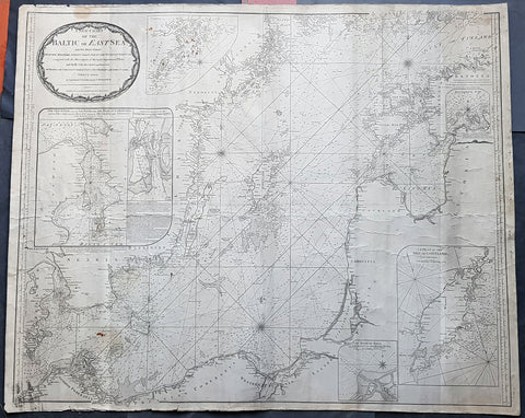
- Title : A New Chart of the Baltic or East Sea Drawn Principally from the Maritime Surveys Collected in the Russian Neptune compared with the Observations of the most experienceed Pilots, and Chiefly with the Charts and Draughts of Professor Christian Charles Lous, Nils Mareluis and James Schmid Published by Authority at Copenhagen, Stockholm and St Petersburg...London Published by Laurie & Whittle No 53 Fleet Street as the Act, 12th May, 1794
- Size: 48in x 39in (1.225m x 1.015mm)
- Condition: (A) Very Good Condition
- Date : 1794
- Ref #: 93046
Description:
This is a very large, extremely rare, copper-plate engraved and highly detailed working Blueback Nautical Chart or Maritime map of the Baltic or East Sea was engraved in 1794 and published by the Laurie & Whittle firm, London 1794. The details for this map have been collected from expeditions by the ship the Russian Neptune and Professor Christian Charles Lous, Nils Mareluis and James Schmid.
This rare Blueback map, a method of mounting working sea charts that was begun by Robert Sayer in the late 18th century. These working maps were extremely expensive to buy and labour intensive to put together so only a limited number were published and sold and even fewer have survived. I have found no other examples of this map either commercially or in other map collections.
The map depicts the Baltic Sea from Scandia Sweden & Pomeranian, Germany in the west to the Baltic States of Estonia and Latvia (Eastland, Livonia, Courland) & southern Finland in the east. The map is highly detailed with numerous cities are labelled, including Copenhagen, Stockholm (Christiana), Gdansk (Dazing), Tallinn (Revel), and Riga. Myriad depth soundings are indicated in the Baltic Sea and along the coastlines. Numerous inset maps are included, the first of Copenhagen and the Straits, the second of Stockholm and directions through the various channels and islands, the third inset is Rogerwick Bay, the fourth is the Island of Gottland and the fifth of Riga and Bay. Copious notes about sailing directions, channels, entrance to the Duna River.
General Definitions:
Paper thickness and quality: - Heavy and stable
Paper color : - off white
Age of map color: -
Colors used: -
General color appearance: -
Paper size: - 48in x 39in (1.225m x 1.015mm)
Plate size: - 48in x 39in (1.225m x 1.015mm)
Margins: - Min 1/2in (12mm)
Imperfections:
Margins: - Soiling, chipping to edges not affecting the image
Plate area: - Soiling, light brown spots top of map, light creasing
Verso: - Original Blueback
Background:
Blueback Charts
Blueback nautical charts began appearing in London in the late 18th century. Bluebacks, as they came to be called, were privately published large format nautical charts known for their distinctive blue paper backing. The backing, a commonly available blue manila paper traditionally used by publishers to warp unbound pamphlets, was adopted as a practical way to reinforce the low-quality paper used by private chart publishers in an effort to cut costs. The earliest known Blueback charts include a 1760 chart issued by Mount and Page, and a 1787 chart issued by Robert Sayer. The tradition took off in the early 19th century, when British publishers like John Hamilton Moore, Robert Blachford, James Imray, William Heather, John William Norie, Charles Wilson, David Steel, R. H. Laurie, and John Hobbs, among others, rose to dominate the chart trade. Bluebacks became so popular that the convention was embraced by chartmakerJacques Nicholas Bellins outside of England, including Americans Edmund March Blunt and George Eldridge, as well as Scandinavian, French, German, Russian, and Spanish chartmakers. Blueback charts remained popular until the late 19th century, when government subsidized organizations like the British Admiralty Hydrographic Office and the United States Coast Survey, began issuing their own superior charts on high quality paper that did not require reinforcement.
1794 Laurie & Whittle, John Rocque Large Antique Map England & Wales, Sea Battle
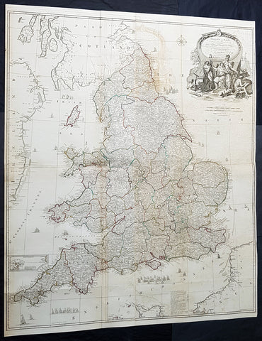
- Titles: England and Wales Drawn from the Most Accurate Surveys...by John Rocque...Laurie & whittle...1794
Sizes: 47 1/2in x 39 1/2in (1.21m x 1.050m) - Condition: (A) Very Good Condition
- Date: 1794
- Ref #: 93417-1
Description:
This very large - 4 sheet joined - famous mid 18th century original hand coloured copper-plate engraved antique map of England and Wales, by John Rocque, was published by Laurie & Whittle in the large 1794 - dated - of A General Atlas Describing the Whole Universe.
General Definitions:
Paper thickness and quality: - Heavy and stable
Paper color : - off white
Age of map color: - Original
Colors used: - Yellow, green, blue, pink
General color appearance: - Authentic
Paper size: - 47 1/2in x 39 1/2in (1.21m x 1.050m)
Plate size: - 47 1/2in x 39 1/2in (1.21m x 1.050m)
Margins: - Min 1/2in (10mm)
Imperfections:
Margins: - None
Plate area: - Folds as issued, offsetting, uplift and creasing along some folds
Verso: - Folds as issued
Background:
The map exemplifies the strong graphic presence of Rocques signature topographic detail as well as an elaborate cartouche, here uncolored as issued. Rocque is recognized as an innovator of the British town plan and a master of large-scale cartographic style. The map of England and Wales was conceived during the high point of the map makers career and seems to have been completed as a part of a series of four-sheet British Isles maps.
A wonderfully detailed four-sheet map with title contained within a large decorative allegorical cartouche depicting the artistic, scientific, and commercial accomplishments of the English. Abbeys and castles are duly noted. Small inset of the Isles of Scilly. Tall ships sailing solo and as part of fleets decorate the seas around the islands.
1794 Laurie, Whittle & Kitchin Very Large Original Antique Map of South America - Rare
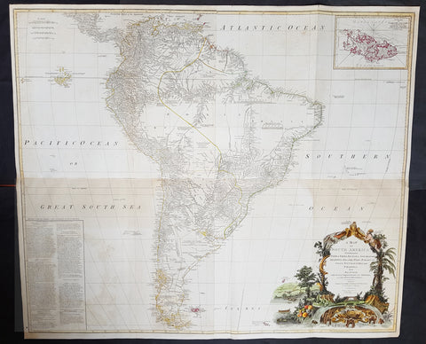
- Title : A Map of South America containing Tierra-Firma, Guayana, New Granada, Amazonia, Brasil, Peru, Paraguay, Chaco, Tucuman, Chili and Patagonia from M. d'Anville with Several Imporvements and Additions, and The Newest Discoveries.
- Date : 1794
- Size: 48in x 41in (1.22m x 1.10m)
- Ref #: 16257
- Condition: (+) Very Good Condition
Description: This very large, incredibly important, highly detailed beautifully hand coloured original antique map of South America, with contributions from two prominent 18th century cartographers, Thomas Kitchin & Jean-Baptiste Bourguinon D'Anville, was updated and published by Laurie & Whittle in 1794, dated in the title cartouche, for the Elephant Folio General Atlas.
Condition Report:
Paper thickness and quality: - Heavy and stable
Paper colour: - Off white
Age of map colour: - Original & early
Colours used: - Yellow, pink, green
General colour appearance: - Authentic
Paper size: - 48in x 41in (1.22m x 1.10m)
Plate size: - 47in x 40in (1.19m x 1.04m)
Margins: - Min 1/2in (10mm)
Imperfections:
Margins: - Small repair to bottom margin,
Plate area: - Folds as issued, offsetting & browning to bottom half of image
Verso: - Folds as issued, light browning
Background:
This is probably the most important two panel wall map of South America produced in the 18th century. Largely based upon the earlier D'Anville map, this map has been enlarged and expanded by the English publishing house of Laurie and Whittle. Depicts the continent in full with an inset of the Falkland Islands. This map is unique in that it is a serious attempt to compile all of the accurate scientific knowledge of the South American continent available at the time. Offers a smorgasbord of factual, speculative, and historical detail.
This extraordinary and highly decorative map bears up to almost endless perusal and volumes could be composed upon its content. The cartographer attempts to depict both known and unknown parts of the continent with actual data reported by both contemporary and historic travelers. In most cases it is extremely difficult to identify specific sources as much of the data is vague and uncertain.
Our survey of this map beings with the coast which Spanish and Portuguese navigators had mapped with considerable accuracy as early as the late 16th century. This, like most early maps of the area, contrasts a detailed mapping of the coast with a speculative discussion of the interior, particularly Patagonia and the Amazon Basin. Offers a fairly accurate discussion of both the east and west coasts with exceptional detail in the populated Andean regions of Venezuela, Columbia, Ecuador (Labeled Quito), and Peru. Notes Cuzco, Lima, Quito, Valladolid, Arequipa, Trujillo and other important trading centers of the region. In Portuguese controlled Brazil, Rio de Janeiro, San Salvador and San Sebastian are noted.
It is in the interior that this map becomes exceptionally fascinating. In the northern part of the continent D'Anville maps a number of confusions associated with the English adventurer Sir Walter Raleigh's search for El Dorado. Believing El Dorado to lie in the northern part of the Amazon, Raleigh sailed down the Orinoco River just before the onset of the rainy season. Reaching a remote tribal village, Raleigh noted canoes arriving bearing gold, silver, and other treasures. Asked where the gold came from, the natives replied, 'Manoa,' the term for the tribe to which the river traders belonged. Manoa, the natives claimed could be reached following a long river voyage southward to a Great Lake, called Parima. Raleigh and his associates immediately associated Manoa and Lake Parima with the golden kingdom of El Dorado, though they never visited the city or lake. Subsequent maps, including this one, mapped El Dorado and Lake Parima in this location for several hundred years. Both Raleigh and the natives were describing an actual event known to occur annually in the region. Rains would annually swell the Amazon and Orinoco river systems creating a linkage in the Parima flood plain, which, during heavy rains, can resemble a massive lake. The Manoa were a large and populous trading nation active pre-colonial days whose vast empire, based in the Amazon Basin, extended form the Andes to the Orinoco. Curiously, in addition to noting the city of Manoa on Lake Parima, D'Anville also correctly maps the center of the ancient Manoan civilization between the Amazon tributaries Rio Negro and Rio Yapura. Sadly the Manoa and many of the other populous South American indigenous nations noted by the earliest explores to the region vanished, brought low by European epidemics.
A similar error appears far to the south where the Paraguay rivers empties into the Laguna de Xarayes. The Xarayes, a corruption of 'Xaraies' meaning 'Masters of the River,' were an indigenous people occupying what are today parts of Brazil's Matte Grosso and the Pantanal. When Spanish and Portuguese explorers first navigated up the Paraguay River, as always in search of El Dorado, they encountered the vast Pantanal flood plain at the height of its annual inundation. Understandably misinterpreting the flood plain as a gigantic inland sea, they named it after the local inhabitants, the Xaraies. The Laguna de los Xarayes almost immediately began to appear on early maps of the region and, at the same time, almost immediately took on a legendary aspect. Later missionaries and chroniclers, particularly Diaz de Guzman, imagined an island in this lake and curiously identified it as an 'Island of Paradise,'
...an island [of the Paraguay River] more than ten leagues [56 km] long, two or three [11-16 km] wide. A very mild land rich in a thousand types of wild fruit, among them grapes, pears and olives: the Indians created plantations throughout, and throughout the year sow and reap with no difference in winter or summer, ... the Indians of that island are of good will and are friends to the Spaniards; Orejon they call them, and they have their ears pierced with wheels of wood ... which occupy the entire hole. They live in round houses, not as a village, but each apart though keep up with each other in much peace and friendship. They called of old this island Land of Paradise for its abundance and wonderful qualities.
To the north of the 'Island of Paradise' appeared the 'Puerto de los Reyes' which was considered to be a gateway to the Amazon and the Kingdom of El Dorado. D'Anville, to his credit, shows the 'Laguna' and it's island in a much reduced form compared to earlier cartographers and also comments that its existence is 'dubious.'
Far to the south Patagonia is crisscrossed with a number of speculative rivers based upon assumptions from earlier cartographers. D'Anville notes several questionable river passes that suggest a possible navigable communication between the east and west coasts of the continent. Speculation on such a pass fueled the famous South Sea Company, one of the modern world's first stock bubbles, but when no such pass was discovered, the bubble burst.
D'Anville also notes several offshore discoveries including the Galapagos, which he calls the Inchanted Islands, the Isle of Georgia, the Juan Fernandez islands, the Falkands, and some curious land masses just west of the Galapagos labeled 'Isles known to the Spanish.' Curiously, he also notes a 'a Bank of Sounding Discovered by Capt. Hook in 1767.' We know of no navigator by the name of Captain Hook except Peter Pan's fictional nemesis. Most likely this is a misprinted reference to Captain Cook, who was active in the Atlantic at this time. One can only wonder if J.M. Barrie had this map handy when imagining his fictional villain.
Prepared from work by D'Anville and published by Laurie & Whittle in Kitchin's 1794 General Atlas.