John Rocque
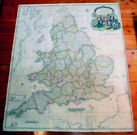
1761 John Rocque & Robert Sayer Very Large Antique Map of England & Wales
- Title : England and Wales Drawn from the Most Accurate Surveys...by John Rocque
- Date : 1761
- Condition: (A) Very Good Condition
- Ref: 92242
- Size: 49in x 37in (1.25m x 1.00m)
Description:
This very large - 4 sheet joined - famous mid 18th century original antique map of England and Wales by John Rocque was published by Robert Sayer in the large 1761 edition of A General Atlas Describing the Whole Universe.
This map is extremely detailed denoting nearly every town river canal and point of interest. This type of cartography is indicative of the British attention to detail & research that helped Britain become the world power over the next 150 years.
John Rocque c. 1704-62 - Little is known of John Rocque's early life except that he was of Huguenot extraction and was living and working in London as an engraver from about 1734. His early experience in preparing plans of great houses and gardens for the nobility led him to take up large-scale surveying for which he developed a distinctive and effective style involving new ways of indicating land use and hill contours. He is best known for a very large-scale plan of London published in 1746 and for a pocket set of county maps, The English Traveller, issued in the same year. He spent some years in Ireland surveying for estate maps and in 1756 he published a well-known Exact Survey of the City of Dublin.
Rocque was Topographer to the Prince of Wales and attained his new title after the coronation in 1760. He flourished from 1734-62. Sayer, a famous and prolific mapmaker, was taken into partnership by John Overton in 1745. After his death in 1752 Sayer continued on his own forming several associations until his own death in 1792. His association with Rocque began in 1753. (Ref:M&B; Tooley)
General Description:
Paper thickness and quality: - Heavy & stable
Paper color: - White
Age of map color: - Original & later
Colors used: - Blue, brown
General color appearance: - Authentic
Paper size: - 49in x 37in (1.25m x 1.00m)
Paper size: - 49in x 37in (1.25m x 1.00m)
Margins: - Min 1/2in (12mm)
Imperfections:
Margins: - Several folds re-enforced and re-joined
Plate area: - Folds as issued, light offsetting, several folds re-enforced and re-joined
Verso: - Several folds re-enforced and re-joined

