Jodocus Hondius
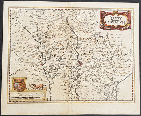
1628 Henricus Hondius Antique Map The Province of Quercy, Lot, Cahors, SW France
- Title : Quercy - Cadurcium
- Ref #: 26140
- Size: 21 1/2in x 17 1/2in (490mm x 340mm)
- Date : 1628
- Condition: (A) Very Good Condition
Description:
This beautifully hand coloured original copper-plate engraved antique map of the ancient province of Quercy located in southwest France - centering on the city of Cahors & the River Lot - was published in the 1628 French edition of Mercators Atlas by Henricus Hondius and Jan Jansson.
General Definitions:
Paper thickness and quality: - Heavy and stable
Paper color : - off white
Age of map color: - Original
Colors used: - Yellow, green, blue, pink
General color appearance: - Authentic
Paper size: - 21 1/2in x 17 1/2in (490mm x 340mm)
Plate size: - 20in x 15in (510mm x 380mm)
Margins: - Min 1/2in (12mm)
Imperfections:
Margins: - Light age toning
Plate area: - Age toning along centerfold
Verso: - Age toning along centerfold
Background:
Quercy is a former province of France located in the countrys southwest, bounded on the north by Limousin, on the west by Périgord and Agenais, on the south by Gascony and Languedoc, and on the east by Rouergue and Auvergne.
Under the Romans Quercy was part of Aquitania prima, and Christianity was introduced during the 4th century. Early in the 6th century it fell under the authority of the Franks, and in the 7th century became part of the autonomous Duchy of Aquitaine. At the end of the 10th century its rulers were the powerful counts of Toulouse. During the wars between England and France in the reign of Henry II, the English placed garrisons in the county, and by the 1259 Treaty of Paris lower Quercy was ceded to England. The monarchs of both England and France confirmed and added to the privileges of the towns and the district, each thus hoping to attach the inhabitants to his own interest. In 1360, by the Treaty of Bretigny, the whole county passed to England, but in 1440 the English were finally expelled. In the 16th century Quercy was a stronghold of the Protestants, and the scene of a savage religious warfare. The civil wars of the reign of Louis XIII largely took place around Montauban.

1628 Jodocus Hondius & Gerard Mercator Antique Map of Africa - Beautiful
- Title : Nova Africae Tabula. Auctore Jodoco Hondio Excusum in aedibus Auctoris Amsterodami.
- Ref #: 35626
- Condition: (A+) Fine Condition
- Size: 22 1/2in x 17 1/4in (615mm x 530mm)
- Date: 1628
Description:
This original beautifully hand coloured copper plate engraved antique map of Africa by Jodocus Hondius, after Gerard Mercator, was published in the 1628 Latin edition of Mercators Atlas Atlas Sive Cosmographicae Meditationes De Fabrica Mundi
This is a beautiful map with original hand colouring, heavy age toned paper with a deep impression. Beautiful map.
General Definitions:
Paper thickness and quality: - Heavy and stable
Paper color : - Off white
Age of map color: - Original
Colors used: - Yellow, green, blue, pink
General color appearance: - Authentic
Paper size: - 22 1/2in x 17 1/4in (615mm x 530mm)
Plate size: - 20in x 15in (510mm x 385mm)
Margins: - Min 1/2in (12mm)
Imperfections:
Margins: - None
Plate area: - None
Verso: - None
Background:
Being part of the Mediterranean world, the northern coasts of the African continent as far as the Straits of Gibraltar and even round to the area of the Fortunate Isles (the Canaries) were reasonably well known and quite accurately mapped from ancient times. In particular, Egypt and the Nile Valley were well defined and the Nile itself was, of course, one of the rivers separating the continents in medieval T-O maps. Through Arab traders the shape of the east coast, down the Red Sea as far as the equator, was also known but detail shown in the interior faded into deserts with occasional mountain ranges and mythical rivers. The southern part of the continent, in the Ptolemaic tradition, was assumed to curve to the east to form a land-locked Indian Ocean. The voyages of the Portuguese, organized by Henry the Navigator in the fifteenth century, completely changed the picture and by the end of the century Vasco da Gama had rounded the Cape enabling cartographers to draw a quite presentable coastal outline of the whole continent, even if the interior was to remain largely unknown for the next two or three centuries.
The first separately printed map of Africa (as with the other known continents) appeared in Munster\'s Geographia from 1540 onwards and the first atlas devoted to Africa only was published in 1588 in Venice by Livio Sanuto, but the finest individual map of the century was that engraved on 8 sheets by Gastaldi, published in Venice in 1564. Apart from maps in sixteenth-century atlases generally there were also magnificent marine maps of 1596 by Jan van Linschoten (engraved by van Langrens) of the southern half of the continent with highly imaginative and decorative detail in the interior. In the next century there were many attractive maps including those of Mercator/Hondius (1606), Speed (1627), Blaeu (1 630), Visscher (1636), de Wit (c. 1670), all embellished with vignettes of harbours and principal towns and bordered with elaborate and colourful figures of their inhabitants, but the interior remained uncharted with the exception of that part of the continent known as Ethiopia, the name which was applied to a wide area including present-day Abyssinia. Here the legends of Prester John lingered on and, as so often happened in other remote parts of the world, the only certain knowledge of the region was provided by Jesuit missionaries. Among these was Father Geronimo Lobo (1595-1678), whose work A Voyage to Abyssinia was used as the basis for a remarkably accurate map published by a German scholar, Hiob Ludolf in 1683. Despite the formidable problems which faced them, the French cartographers G. Delisle (c. 1700-22), J. B. B. d\'Anville (1727-49) and N. Bellin (1754) greatly improved the standards of mapping of the continent, improvements which were usually, although not always, maintained by Homann, Seutter, de Ia Rochette, Bowen, Faden and many others in the later years of the century.
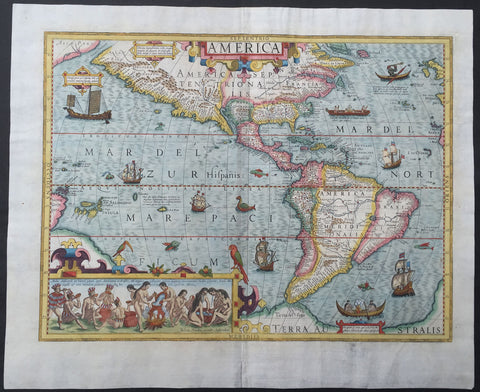
1630 Jodocus Hondius Antique Map of America
- Title : America
- Ref #: 61032
- Size: 22 1/4in x 18 1/4in (565mm x 465mm)
- Date : 1630
- Condition: (A+) Fine Condition
Description:
This magnificent and extremely important, hand coloured original antique map of America was drawn and engraved by Jodocus Hondius for inclusion in his editions of Gerard Mercator's Atlas sive Cosmographicae between 1606 and 1630. This actual map is from the last 1630 Latin edition, identified by the text line Mmmmmmmm on the verso of the map.
This map like many of the time was published on a stereographic projection and is an amalgam of various sources. It incorporates a more correct west coast of South America and narrows still further the longitudinal width of New Spain at the Tropic of Cancer, making it just 10°, much closer in reality. However, like all cartography before, it still retains an enlarged North American continent.
A Plancius type depiction of Newfoundland occurs alongside a typical representation of the east coast, with a more protruding Virginia than usual. Various scenes taken from earlier volumes of de Bry's Grand Voyages adorn the whole. Particularly notable is the native Brazilian scene illustrating the method used to make the local beverage, derived from Hans Stadens voyage as recorded by de Bry.
There are various galleons, kayaks and Indian canoes along with a pair of birds perched on the inset.
Background: This map was engraved by Jodocus Hondius for his first edition of Gerard Mercator's atlas. Intended to be a grand comprehensive work, with the first part originally appearing in 1585, by Mercator's death in 1594 only two parts had been published. Continued by his family, it was still incomplete for the 1602 edition, lacking most importantly a section on the Iberian peninsula. During this time it was also competing with the remarkably successful atlas of Abraham Ortelius which averaged almost one edition per year. By 1604 Jodocus Hondius was flourishing, and in that year acquired all of the plates from Mercator's descendant. He immediately set about engraving many new maps to augment and complete the work, amongst which was a set of the four continents. He also had the original text expanded by Petrus Montanus. In the following year he brought out Mercator's Ptolemy, and in 1606 his first edition of the general atlas which proved instantly popular, selling out within a year.
Right up until 1630 this attractive map was issued alongside the AMERICA sive INDIA NOVA by Michael Mercator, 1595. Since the text describing America was always used by the Mercator, this one is always lacking one. Produced on a stereographic projection like more and more maps of the time, it is an amalgam of various sources. (Ref: Burden; Koeman; M&B; Tooley)
Condition Report
Paper thickness and quality: - Heavy and stable
Paper color: - White
Age of map color: - Original & later
Colors used: - Red, yellow, green
General color appearance: - Authentic
Paper size: - 22 1/4in x 18 1/4in (565mm x 465mm)
Plate size: - 19 3/4in x 14 3/4in (500mm x 375mm)
Margins: - Min 1in (25mm)
Imperfections:
Margins: - Professional repair to bottom center-fold and bottom left margin 1 1/2in into image, no loss
Plate area: - None
Verso: - Light age toning
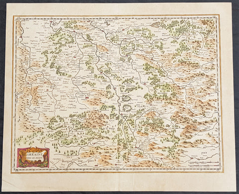
1638 Joducus Hondius Antique Map of the Lorraine Region of NE France - Grand Est
- Title : Lorraine Vers Le Midy
- Ref #: 50250
- Size: 21 1/2in x 17 1/2in (545mm x 445mm)
- Date : 1638
- Condition: (A) Very Good Condition
Description:
This beautifully hand coloured original antique map of the ancient Lorraine region of France - centering on the Moselle River with the city of Nancy to the north Faucogney-et-la-Mer to the south & the Meuse River to the west - by Gerard Mercator was published by Jodocus Hondius in the 1638 edition of Mercators Atlas.
General Definitions:
Paper thickness and quality: - Heavy and stable
Paper color : - off white
Age of map color: - Original
Colors used: - Yellow, green, blue, pink
General color appearance: - Authentic
Paper size: - 21 1/2in x 17 1/2in (545mm x 445mm)
Plate size: - 19 1/2in x 15 1/2in (500mm x 395mm)
Margins: - Min 1/2in (12mm)
Imperfections:
Margins: - Light age toning
Plate area: - None
Verso: - Light age toning
Background:
Lorraine is a cultural and historical region in north-eastern France, now located in the administrative region of Grand Est. Lorraines name stems from the medieval kingdom of Lotharingia, which in turn was named for either Emperor Lothair I or King Lothair II. It later was ruled as the Duchy of Lorraine before the Kingdom of France annexed it in 1766.
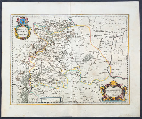
1639 Hondius Old, Antique Map of Henneberg, Thuringia Region Germany - Meiningen
- Title : Principatus Hennenbergensis
- Ref #: 23433
- Size: 23in x 19in (585mm x 485mm)
- Date : 1639
- Condition: (A+) Fine Condition
Description:
This beautifully hand coloured original antique map of the Henneberg county in the Thuringia region of Southern Germany - centering on the cities of Henneberg andMeiningen was published in the 1639 French edition of Mercators Atlas published by Henricus Hondius and Jan Jansson. (Ref: Koeman; Tooley; M&B)
Condition Report:
Paper thickness and quality: - Heavy and stable
Paper color: - off white
Age of map color: - Early
Colors used: - Yellow, pink, green
General color appearance: - Authentic
Paper size: - 23in x 19in (585mm x 485mm)
Plate size: - 19 1/2in x 15in (495mm x 380mm)
Margins: - Min 1in (25mm)
Imperfections:
Margins: - None
Plate area: - None
Verso: - None