Jeremais Wolff
1740 Wolff & Corvinus Antique Arch Plan Officers Quarters, Royal Arsenal, Berlin
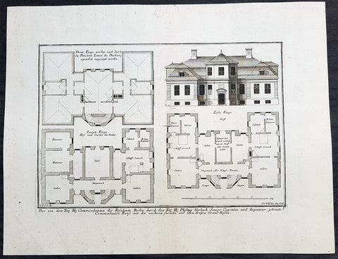
- Title : Das von dem Tit. H. Commendanten der Residentz Berlin, durch den Tit. H. Philipp Gerlach Senior Capitain und Ingenieur gebaute Commendaten Hauß mit der vorderen faciata und allen dreyen Grund-Rissen
- Ref #: 93449
- Size: 19 1/2in x 15in (495mm x 390mm)
- Date : 1740
- Condition: (A+) Fine Condition
Description:
This large rare, original copper-plate engraved antique architectural print, view & plan of officers quarters at the Royal Arsenal in Berlin - plate No.17 of 19 - by Johann August Corvinus 1683 - 1738, after Andreas Mayers 1716 - 1782, was published in Eigentliche Abbildung des Prächtigen Königl. Lust Schlosses Charlottenburg, eine Meile von Berlin, sambt dem darhinden im Walde gelegenen schönen Lust Garten
(Set of 16 numbered plates, the first with the title, with plans and views of the buildings and gardens at Charlottenburg, the palace of the King of Prussia on the outskirts of Berlin.) by Jeremias Wolff Erben in 1740.
General Definitions:
Paper thickness and quality: - Heavy and stable
Paper color : - off white
Age of map color: -
Colors used: -
General color appearance: -
Paper size: - 19in x 12 1/2in (490mm x 335mm)
Plate size: - 14 1/2in x 10 1/2in (370mm x 260mm)
Margins: - Min 1in (25mm)
Imperfections:
Margins: - None
Plate area: - None
Verso: - None
Background:
Berlin straddles the banks of the River Spree, which flows into the River Havel (a tributary of the River Elbe) in the western borough of Spandau. Among the citys main topographical features are the many lakes in the western and southeastern boroughs formed by the Spree, Havel, and Dahme rivers (the largest of which is Lake Müggelsee). Due to its location in the European Plain, Berlin is influenced by a temperate seasonal climate. About one-third of the citys area is composed of forests, parks, gardens, rivers, canals and lakes. The city lies in the Central German dialect area, the Berlin dialect being a variant of the Lusatian-New Marchian dialects.
First documented in the 13th century and situated at the crossing of two important historic trade routes, Berlin became the capital of the Margraviate of Brandenburg (1417–1701), the Kingdom of Prussia (1701–1918), the German Empire (1871–1918), the Weimar Republic (1919–1933), and the Third Reich (1933–1945). Berlin in the 1920s was the third-largest municipality in the world. After World War II and its subsequent occupation by the victorious countries, the city was divided; West Berlin became a de facto West German exclave, surrounded by the Berlin Wall (1961–1989) and East German territory. East Berlin was declared capital of East Germany, while Bonn became the West German capital. Following German reunification in 1990, Berlin once again became the capital of all of Germany.
The Thirty Years War between 1618 and 1648 devastated Berlin. One third of its houses were damaged or destroyed, and the city lost half of its population. Frederick William, known as the Great Elector, who had succeeded his father George William as ruler in 1640, initiated a policy of promoting immigration and religious tolerance. With the Edict of Potsdam in 1685, Frederick William offered asylum to the French Huguenots.
By 1700, approximately 30 percent of Berlins residents were French, because of the Huguenot immigration. Many other immigrants came from Bohemia, Poland, and Salzburg.
Since 1618, the Margraviate of Brandenburg had been in personal union with the Duchy of Prussia. In 1701, the dual state formed the Kingdom of Prussia, as Frederick III, Elector of Brandenburg, crowned himself as king Frederick I in Prussia. Berlin became the capital of the new Kingdom, replacing Königsberg. This was a successful attempt to centralise the capital in the very far-flung state, and it was the first time the city began to grow. In 1709, Berlin merged with the four cities of Cölln, Friedrichswerder, Friedrichstadt and Dorotheenstadt under the name Berlin, Haupt- und Residenzstadt Berlin.
In 1740, Frederick II, known as Frederick the Great (1740–1786), came to power. Under the rule of Frederick II, Berlin became a center of the Enlightenment, but also, was briefly occupied during the Seven Years War by the Russian army. Following Frances victory in the War of the Fourth Coalition, Napoleon Bonaparte marched into Berlin in 1806, but granted self-government to the city. In 1815, the city became part of the new Province of Brandenburg.
The Industrial Revolution transformed Berlin during the 19th century; the citys economy and population expanded dramatically, and it became the main railway hub and economic centre of Germany. Additional suburbs soon developed and increased the area and population of Berlin. In 1861, neighbouring suburbs including Wedding, Moabit and several others were incorporated into Berlin. In 1871, Berlin became capital of the newly founded German Empire. In 1881, it became a city district separate from Brandenburg.
Wolff, Jeremais 1663 - 1724
Wolff was an German engraver and publisher. Born in Augsburg, he originally trained as a clock and automat maker, later changing course and opening a small copperplate engraving shop. His success was impressive and became one of the largest European art, print & map publishers in the first half of the 18th century. Wolff employed some of the best engravers of the time and although not an engraver himself, only Wolffs name was recorded on the engravings. Many of his engravers went uncredited for their work. In 1710 Wolff was one of the founder member of the Empire State Academy of Arts in Augsburg.
After his death in 1724, Wolffs publishing business was inherited by his sons and son-in-law, Johann Balthasar Probst (1673–1750) a notable engraver at the time. The firm continued on in Augsburg under the name Jeremias Wolff Erben.
Together with the Nuremberg copperplate engraver Paul Decker , Wolff published a series of engravings showing the war successes of Prince Eugene of Savoy in Italy , southern Germany and the Spanish Netherlands, during the War of the Spanish Succession . The prints are exhibited in the Museum of Military History, in Vienna .
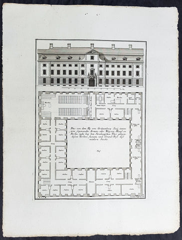
1740 Wolff & Corvinus Antique Arch Print of a Poorhouse near Stralau Gate Berlin
- Title : Das von dem H. von Grünenberg Seel. inventirte sogenandte Armen- oder Waysen-Hauss zu Berlin, nache bey dem Stralauischen Thor gelegen, ....
- Ref #: 93455
- Size: 19in x 12 1/2in (490mm x 335mm)
- Date : 1740
- Condition: (A+) Fine Condition
Description:
This large rare, original copper-plate engraved antique architectural print of the Poorhouse near the old Stralau Gate (Stralauer Tor) in Berlin - plate No. 8 of 16 - by Johann August Corvinus 1683 - 1738, after Andreas Mayers 1716 - 1782, was published in Eigentliche Abbildung des Prächtigen Königl. Lust Schlosses Charlottenburg, eine Meile von Berlin, sambt dem darhinden im Walde gelegenen schönen Lust Garten
(Set of 16 numbered plates, the first with the title, with plans and views of the buildings and gardens at Charlottenburg, the palace of the King of Prussia on the outskirts of Berlin.) by Jeremias Wolff Erben in 1740.
General Definitions:
Paper thickness and quality: - Heavy and stable
Paper color : - off white
Age of map color: -
Colors used: -
General color appearance: -
Paper size: - 19in x 12 1/2in (490mm x 335mm)
Plate size: - 14 1/2in x 10 1/2in (370mm x 260mm)
Margins: - Min 1in (25mm)
Imperfections:
Margins: - None
Plate area: - None
Verso: - None
Background:
Berlin straddles the banks of the River Spree, which flows into the River Havel (a tributary of the River Elbe) in the western borough of Spandau. Among the citys main topographical features are the many lakes in the western and southeastern boroughs formed by the Spree, Havel, and Dahme rivers (the largest of which is Lake Müggelsee). Due to its location in the European Plain, Berlin is influenced by a temperate seasonal climate. About one-third of the citys area is composed of forests, parks, gardens, rivers, canals and lakes. The city lies in the Central German dialect area, the Berlin dialect being a variant of the Lusatian-New Marchian dialects.
First documented in the 13th century and situated at the crossing of two important historic trade routes, Berlin became the capital of the Margraviate of Brandenburg (1417–1701), the Kingdom of Prussia (1701–1918), the German Empire (1871–1918), the Weimar Republic (1919–1933), and the Third Reich (1933–1945). Berlin in the 1920s was the third-largest municipality in the world. After World War II and its subsequent occupation by the victorious countries, the city was divided; West Berlin became a de facto West German exclave, surrounded by the Berlin Wall (1961–1989) and East German territory. East Berlin was declared capital of East Germany, while Bonn became the West German capital. Following German reunification in 1990, Berlin once again became the capital of all of Germany.
The Thirty Years War between 1618 and 1648 devastated Berlin. One third of its houses were damaged or destroyed, and the city lost half of its population. Frederick William, known as the Great Elector, who had succeeded his father George William as ruler in 1640, initiated a policy of promoting immigration and religious tolerance. With the Edict of Potsdam in 1685, Frederick William offered asylum to the French Huguenots.
By 1700, approximately 30 percent of Berlins residents were French, because of the Huguenot immigration. Many other immigrants came from Bohemia, Poland, and Salzburg.
Since 1618, the Margraviate of Brandenburg had been in personal union with the Duchy of Prussia. In 1701, the dual state formed the Kingdom of Prussia, as Frederick III, Elector of Brandenburg, crowned himself as king Frederick I in Prussia. Berlin became the capital of the new Kingdom, replacing Königsberg. This was a successful attempt to centralise the capital in the very far-flung state, and it was the first time the city began to grow. In 1709, Berlin merged with the four cities of Cölln, Friedrichswerder, Friedrichstadt and Dorotheenstadt under the name Berlin, Haupt- und Residenzstadt Berlin.
In 1740, Frederick II, known as Frederick the Great (1740–1786), came to power. Under the rule of Frederick II, Berlin became a center of the Enlightenment, but also, was briefly occupied during the Seven Years War by the Russian army. Following Frances victory in the War of the Fourth Coalition, Napoleon Bonaparte marched into Berlin in 1806, but granted self-government to the city. In 1815, the city became part of the new Province of Brandenburg.
The Industrial Revolution transformed Berlin during the 19th century; the citys economy and population expanded dramatically, and it became the main railway hub and economic centre of Germany. Additional suburbs soon developed and increased the area and population of Berlin. In 1861, neighbouring suburbs including Wedding, Moabit and several others were incorporated into Berlin. In 1871, Berlin became capital of the newly founded German Empire. In 1881, it became a city district separate from Brandenburg.
Wolff, Jeremais 1663 - 1724
Wolff was an German engraver and publisher. Born in Augsburg, he originally trained as a clock and automat maker, later changing course and opening a small copperplate engraving shop. His success was impressive and became one of the largest European art, print & map publishers in the first half of the 18th century. Wolff employed some of the best engravers of the time and although not an engraver himself, only Wolffs name was recorded on the engravings. Many of his engravers went uncredited for their work. In 1710 Wolff was one of the founder member of the Empire State Academy of Arts in Augsburg.
After his death in 1724, Wolffs publishing business was inherited by his sons and son-in-law, Johann Balthasar Probst (1673–1750) a notable engraver at the time. The firm continued on in Augsburg under the name Jeremias Wolff Erben.
Together with the Nuremberg copperplate engraver Paul Decker , Wolff published a series of engravings showing the war successes of Prince Eugene of Savoy in Italy , southern Germany and the Spanish Netherlands, during the War of the Spanish Succession . The prints are exhibited in the Museum of Military History, in Vienna .
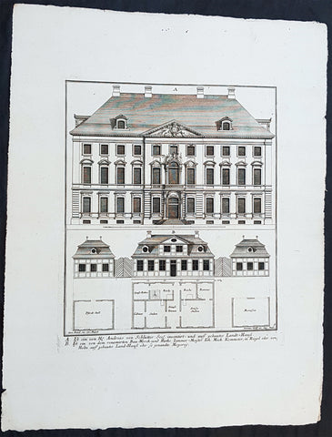
1740 Wolff & Corvinus Antique Arch Print of Berlin Mansions by A. von Schlütter
- Title : A. Ist ein von H. Andreas von Schlütter Seel. inventirt- und auff gebautes Landt-Hauss. B. Ist ein von dem renomirten Bau-Werck- und Raths Zimmer-Meister Joh. Mich. Kemmeter, in Riegel oder Holtz auff gebautes Land-Hauß oder so genandte Meyerey
- Ref #: 93445
- Size: 19in x 12 1/2in (490mm x 335mm)
- Date : 1740
- Condition: (A+) Fine Condition
Description:
This large rare, original copper-plate engraved antique architectural print of 18th century Mansions in Berlin designed by Andreas von Schlütter - plate No. 9 of 16 - by Johann August Corvinus 1683 - 1738, after Andreas Mayers 1716 - 1782, was published in Eigentliche Abbildung des Prächtigen Königl. Lust Schlosses Charlottenburg, eine Meile von Berlin, sambt dem darhinden im Walde gelegenen schönen Lust Garten
(Set of 16 numbered plates, the first with the title, with plans and views of the buildings and gardens at Charlottenburg, the palace of the King of Prussia on the outskirts of Berlin.) by Jeremias Wolff Erben in 1740.
General Definitions:
Paper thickness and quality: - Heavy and stable
Paper color : - off white
Age of map color: -
Colors used: -
General color appearance: -
Paper size: - 19in x 12 1/2in (490mm x 335mm)
Plate size: - 14 1/2in x 10 1/2in (370mm x 260mm)
Margins: - Min 1in (25mm)
Imperfections:
Margins: - None
Plate area: - None
Verso: - None
Background:
Berlin straddles the banks of the River Spree, which flows into the River Havel (a tributary of the River Elbe) in the western borough of Spandau. Among the citys main topographical features are the many lakes in the western and southeastern boroughs formed by the Spree, Havel, and Dahme rivers (the largest of which is Lake Müggelsee). Due to its location in the European Plain, Berlin is influenced by a temperate seasonal climate. About one-third of the citys area is composed of forests, parks, gardens, rivers, canals and lakes. The city lies in the Central German dialect area, the Berlin dialect being a variant of the Lusatian-New Marchian dialects.
First documented in the 13th century and situated at the crossing of two important historic trade routes, Berlin became the capital of the Margraviate of Brandenburg (1417–1701), the Kingdom of Prussia (1701–1918), the German Empire (1871–1918), the Weimar Republic (1919–1933), and the Third Reich (1933–1945). Berlin in the 1920s was the third-largest municipality in the world. After World War II and its subsequent occupation by the victorious countries, the city was divided; West Berlin became a de facto West German exclave, surrounded by the Berlin Wall (1961–1989) and East German territory. East Berlin was declared capital of East Germany, while Bonn became the West German capital. Following German reunification in 1990, Berlin once again became the capital of all of Germany.
The Thirty Years War between 1618 and 1648 devastated Berlin. One third of its houses were damaged or destroyed, and the city lost half of its population. Frederick William, known as the Great Elector, who had succeeded his father George William as ruler in 1640, initiated a policy of promoting immigration and religious tolerance. With the Edict of Potsdam in 1685, Frederick William offered asylum to the French Huguenots.
By 1700, approximately 30 percent of Berlins residents were French, because of the Huguenot immigration. Many other immigrants came from Bohemia, Poland, and Salzburg.
Since 1618, the Margraviate of Brandenburg had been in personal union with the Duchy of Prussia. In 1701, the dual state formed the Kingdom of Prussia, as Frederick III, Elector of Brandenburg, crowned himself as king Frederick I in Prussia. Berlin became the capital of the new Kingdom, replacing Königsberg. This was a successful attempt to centralise the capital in the very far-flung state, and it was the first time the city began to grow. In 1709, Berlin merged with the four cities of Cölln, Friedrichswerder, Friedrichstadt and Dorotheenstadt under the name Berlin, Haupt- und Residenzstadt Berlin.
In 1740, Frederick II, known as Frederick the Great (1740–1786), came to power. Under the rule of Frederick II, Berlin became a center of the Enlightenment, but also, was briefly occupied during the Seven Years War by the Russian army. Following Frances victory in the War of the Fourth Coalition, Napoleon Bonaparte marched into Berlin in 1806, but granted self-government to the city. In 1815, the city became part of the new Province of Brandenburg.
The Industrial Revolution transformed Berlin during the 19th century; the citys economy and population expanded dramatically, and it became the main railway hub and economic centre of Germany. Additional suburbs soon developed and increased the area and population of Berlin. In 1861, neighbouring suburbs including Wedding, Moabit and several others were incorporated into Berlin. In 1871, Berlin became capital of the newly founded German Empire. In 1881, it became a city district separate from Brandenburg.
Wolff, Jeremais 1663 - 1724
Wolff was an German engraver and publisher. Born in Augsburg, he originally trained as a clock and automat maker, later changing course and opening a small copperplate engraving shop. His success was impressive and became one of the largest European art, print & map publishers in the first half of the 18th century. Wolff employed some of the best engravers of the time and although not an engraver himself, only Wolffs name was recorded on the engravings. Many of his engravers went uncredited for their work. In 1710 Wolff was one of the founder member of the Empire State Academy of Arts in Augsburg.
After his death in 1724, Wolffs publishing business was inherited by his sons and son-in-law, Johann Balthasar Probst (1673–1750) a notable engraver at the time. The firm continued on in Augsburg under the name Jeremias Wolff Erben.
Together with the Nuremberg copperplate engraver Paul Decker , Wolff published a series of engravings showing the war successes of Prince Eugene of Savoy in Italy , southern Germany and the Spanish Netherlands, during the War of the Spanish Succession . The prints are exhibited in the Museum of Military History, in Vienna .
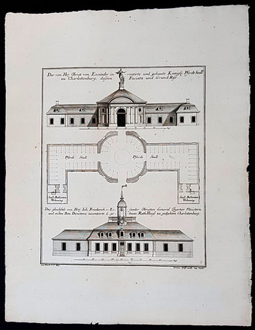
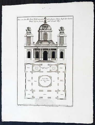
1740 Wolff & Corvinus Antique Arch Print of Charlottenburg Palace Stables Berlin
- Title : Der von Hr. Obrist von Eosander inventirte und gebaute Königl. Pferdt Stall zu Charlottenburg, dessen Faciata und Grund Riss. - Das gleichfals von Hr. Joh. Friederich v. Eosander Obristen General Quartier Meistern, und ersten Bau Directorn inventierte und gebaute Rath Hauss zu gedachten Charlottenburg
- Ref #: 93453
- Size: 19in x 12 1/2in (490mm x 335mm)
- Date : 1740
- Condition: (A+) Fine Condition
Description:
This large rare, original copper-plate engraved antique architectural print of the Royal Horse Stables at Charlottenburg Palace, Berlin - plate No. 11 of 16 - by Johann August Corvinus 1683 - 1738, after Andreas Mayers 1716 - 1782, was published in Eigentliche Abbildung des Prächtigen Königl. Lust Schlosses Charlottenburg, eine Meile von Berlin, sambt dem darhinden im Walde gelegenen schönen Lust Garten
(Set of 16 numbered plates, the first with the title, with plans and views of the buildings and gardens at Charlottenburg, the palace of the King of Prussia on the outskirts of Berlin.) by Jeremias Wolff Erben in 1740.
General Definitions:
Paper thickness and quality: - Heavy and stable
Paper color : - off white
Age of map color: -
Colors used: -
General color appearance: -
Paper size: - 19in x 12 1/2in (490mm x 335mm)
Plate size: - 14 1/2in x 10 1/2in (370mm x 260mm)
Margins: - Min 1in (25mm)
Imperfections:
Margins: - None
Plate area: - None
Verso: - None
Background:
Berlin straddles the banks of the River Spree, which flows into the River Havel (a tributary of the River Elbe) in the western borough of Spandau. Among the citys main topographical features are the many lakes in the western and southeastern boroughs formed by the Spree, Havel, and Dahme rivers (the largest of which is Lake Müggelsee). Due to its location in the European Plain, Berlin is influenced by a temperate seasonal climate. About one-third of the citys area is composed of forests, parks, gardens, rivers, canals and lakes. The city lies in the Central German dialect area, the Berlin dialect being a variant of the Lusatian-New Marchian dialects.
First documented in the 13th century and situated at the crossing of two important historic trade routes, Berlin became the capital of the Margraviate of Brandenburg (1417–1701), the Kingdom of Prussia (1701–1918), the German Empire (1871–1918), the Weimar Republic (1919–1933), and the Third Reich (1933–1945). Berlin in the 1920s was the third-largest municipality in the world. After World War II and its subsequent occupation by the victorious countries, the city was divided; West Berlin became a de facto West German exclave, surrounded by the Berlin Wall (1961–1989) and East German territory. East Berlin was declared capital of East Germany, while Bonn became the West German capital. Following German reunification in 1990, Berlin once again became the capital of all of Germany.
The Thirty Years War between 1618 and 1648 devastated Berlin. One third of its houses were damaged or destroyed, and the city lost half of its population. Frederick William, known as the Great Elector, who had succeeded his father George William as ruler in 1640, initiated a policy of promoting immigration and religious tolerance. With the Edict of Potsdam in 1685, Frederick William offered asylum to the French Huguenots.
By 1700, approximately 30 percent of Berlins residents were French, because of the Huguenot immigration. Many other immigrants came from Bohemia, Poland, and Salzburg.
Since 1618, the Margraviate of Brandenburg had been in personal union with the Duchy of Prussia. In 1701, the dual state formed the Kingdom of Prussia, as Frederick III, Elector of Brandenburg, crowned himself as king Frederick I in Prussia. Berlin became the capital of the new Kingdom, replacing Königsberg. This was a successful attempt to centralise the capital in the very far-flung state, and it was the first time the city began to grow. In 1709, Berlin merged with the four cities of Cölln, Friedrichswerder, Friedrichstadt and Dorotheenstadt under the name Berlin, Haupt- und Residenzstadt Berlin.
In 1740, Frederick II, known as Frederick the Great (1740–1786), came to power. Under the rule of Frederick II, Berlin became a center of the Enlightenment, but also, was briefly occupied during the Seven Years War by the Russian army. Following Frances victory in the War of the Fourth Coalition, Napoleon Bonaparte marched into Berlin in 1806, but granted self-government to the city. In 1815, the city became part of the new Province of Brandenburg.
The Industrial Revolution transformed Berlin during the 19th century; the citys economy and population expanded dramatically, and it became the main railway hub and economic centre of Germany. Additional suburbs soon developed and increased the area and population of Berlin. In 1861, neighbouring suburbs including Wedding, Moabit and several others were incorporated into Berlin. In 1871, Berlin became capital of the newly founded German Empire. In 1881, it became a city district separate from Brandenburg.
Wolff, Jeremais 1663 - 1724
Wolff was an German engraver and publisher. Born in Augsburg, he originally trained as a clock and automat maker, later changing course and opening a small copperplate engraving shop. His success was impressive and became one of the largest European art, print & map publishers in the first half of the 18th century. Wolff employed some of the best engravers of the time and although not an engraver himself, only Wolffs name was recorded on the engravings. Many of his engravers went uncredited for their work. In 1710 Wolff was one of the founder member of the Empire State Academy of Arts in Augsburg.
After his death in 1724, Wolffs publishing business was inherited by his sons and son-in-law, Johann Balthasar Probst (1673–1750) a notable engraver at the time. The firm continued on in Augsburg under the name Jeremias Wolff Erben.
Together with the Nuremberg copperplate engraver Paul Decker , Wolff published a series of engravings showing the war successes of Prince Eugene of Savoy in Italy , southern Germany and the Spanish Netherlands, during the War of the Spanish Succession . The prints are exhibited in the Museum of Military History, in Vienna .
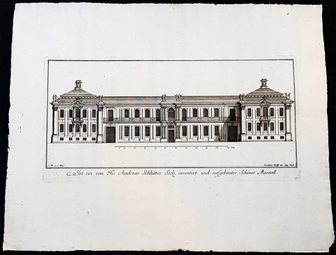
1740 Wolff & Corvinus Antique Arch Print of Charlottenburg Palace Stables Berlin
- Title : Ist ein von Hr. Andreas Schlütter Seel. inventirt und aufgebauer Schöner Marstall Datierung
- Ref #: 93447
- Size: 19in x 12 1/2in (490mm x 335mm)
- Date : 1740
- Condition: (A+) Fine Condition
Description:
This large rare, original copper-plate engraved antique architectural print, view of the facade of the Charlottenburg Palace stables in Berlin - plate No.15 of 16 - by Johann August Corvinus 1683 - 1738, after Andreas Mayers 1716 - 1782, was published in Eigentliche Abbildung des Prächtigen Königl. Lust Schlosses Charlottenburg, eine Meile von Berlin, sambt dem darhinden im Walde gelegenen schönen Lust Garten
(Set of 16 numbered plates, the first with the title, with plans and views of the buildings and gardens at Charlottenburg, the palace of the King of Prussia on the outskirts of Berlin.) by Jeremias Wolff Erben in 1740.
General Definitions:
Paper thickness and quality: - Heavy and stable
Paper color : - off white
Age of map color: -
Colors used: -
General color appearance: -
Paper size: - 19in x 12 1/2in (490mm x 335mm)
Plate size: - 14 1/2in x 10 1/2in (370mm x 260mm)
Margins: - Min 1in (25mm)
Imperfections:
Margins: - None
Plate area: - None
Verso: - None
Background:
Berlin straddles the banks of the River Spree, which flows into the River Havel (a tributary of the River Elbe) in the western borough of Spandau. Among the citys main topographical features are the many lakes in the western and southeastern boroughs formed by the Spree, Havel, and Dahme rivers (the largest of which is Lake Müggelsee). Due to its location in the European Plain, Berlin is influenced by a temperate seasonal climate. About one-third of the citys area is composed of forests, parks, gardens, rivers, canals and lakes. The city lies in the Central German dialect area, the Berlin dialect being a variant of the Lusatian-New Marchian dialects.
First documented in the 13th century and situated at the crossing of two important historic trade routes, Berlin became the capital of the Margraviate of Brandenburg (1417–1701), the Kingdom of Prussia (1701–1918), the German Empire (1871–1918), the Weimar Republic (1919–1933), and the Third Reich (1933–1945). Berlin in the 1920s was the third-largest municipality in the world. After World War II and its subsequent occupation by the victorious countries, the city was divided; West Berlin became a de facto West German exclave, surrounded by the Berlin Wall (1961–1989) and East German territory. East Berlin was declared capital of East Germany, while Bonn became the West German capital. Following German reunification in 1990, Berlin once again became the capital of all of Germany.
The Thirty Years War between 1618 and 1648 devastated Berlin. One third of its houses were damaged or destroyed, and the city lost half of its population. Frederick William, known as the Great Elector, who had succeeded his father George William as ruler in 1640, initiated a policy of promoting immigration and religious tolerance. With the Edict of Potsdam in 1685, Frederick William offered asylum to the French Huguenots.
By 1700, approximately 30 percent of Berlins residents were French, because of the Huguenot immigration. Many other immigrants came from Bohemia, Poland, and Salzburg.
Since 1618, the Margraviate of Brandenburg had been in personal union with the Duchy of Prussia. In 1701, the dual state formed the Kingdom of Prussia, as Frederick III, Elector of Brandenburg, crowned himself as king Frederick I in Prussia. Berlin became the capital of the new Kingdom, replacing Königsberg. This was a successful attempt to centralise the capital in the very far-flung state, and it was the first time the city began to grow. In 1709, Berlin merged with the four cities of Cölln, Friedrichswerder, Friedrichstadt and Dorotheenstadt under the name Berlin, Haupt- und Residenzstadt Berlin.
In 1740, Frederick II, known as Frederick the Great (1740–1786), came to power. Under the rule of Frederick II, Berlin became a center of the Enlightenment, but also, was briefly occupied during the Seven Years War by the Russian army. Following Frances victory in the War of the Fourth Coalition, Napoleon Bonaparte marched into Berlin in 1806, but granted self-government to the city. In 1815, the city became part of the new Province of Brandenburg.
The Industrial Revolution transformed Berlin during the 19th century; the citys economy and population expanded dramatically, and it became the main railway hub and economic centre of Germany. Additional suburbs soon developed and increased the area and population of Berlin. In 1861, neighbouring suburbs including Wedding, Moabit and several others were incorporated into Berlin. In 1871, Berlin became capital of the newly founded German Empire. In 1881, it became a city district separate from Brandenburg.
Wolff, Jeremais 1663 - 1724
Wolff was an German engraver and publisher. Born in Augsburg, he originally trained as a clock and automat maker, later changing course and opening a small copperplate engraving shop. His success was impressive and became one of the largest European art, print & map publishers in the first half of the 18th century. Wolff employed some of the best engravers of the time and although not an engraver himself, only Wolffs name was recorded on the engravings. Many of his engravers went uncredited for their work. In 1710 Wolff was one of the founder member of the Empire State Academy of Arts in Augsburg.
After his death in 1724, Wolffs publishing business was inherited by his sons and son-in-law, Johann Balthasar Probst (1673–1750) a notable engraver at the time. The firm continued on in Augsburg under the name Jeremias Wolff Erben.
Together with the Nuremberg copperplate engraver Paul Decker , Wolff published a series of engravings showing the war successes of Prince Eugene of Savoy in Italy , southern Germany and the Spanish Netherlands, during the War of the Spanish Succession . The prints are exhibited in the Museum of Military History, in Vienna .
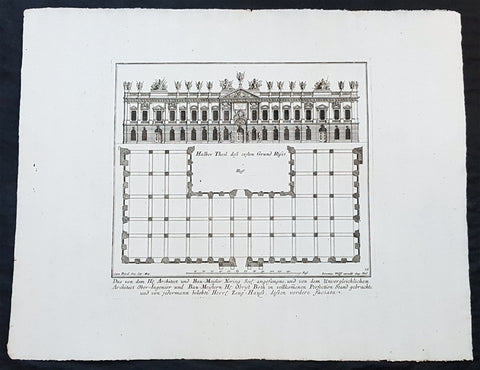
1740 Wolff & Corvinus Antique Arch Print of The Royal Arsenal in Berlin Germany
- Title : Das von dem H. Architect und Bau-Meister Nering Seel. angefangne, und von dem unvergleichlichen Architect Ober-Ingenier und Bau-Meistern H. Obrist Both in vollkommenen Perfection Stand gebrachte und von jedermann belobte Herr. Zeug-Haus, dessen vordere faciata
- Ref #: 93454
- Size: 19in x 12 1/2in (490mm x 335mm)
- Date : 1740
- Condition: (A+) Fine Condition
Description:
This large rare, original copper-plate engraved antique architectural print, view & plan of The Royal Arsenal in Berlin Houses - plate No.13 of 16 - by Johann August Corvinus 1683 - 1738, after Andreas Mayers 1716 - 1782, was published in Eigentliche Abbildung des Prächtigen Königl. Lust Schlosses Charlottenburg, eine Meile von Berlin, sambt dem darhinden im Walde gelegenen schönen Lust Garten
(Set of 16 numbered plates, the first with the title, with plans and views of the buildings and gardens at Charlottenburg, the palace of the King of Prussia on the outskirts of Berlin.) by Jeremias Wolff Erben in 1740.
General Definitions:
Paper thickness and quality: - Heavy and stable
Paper color : - off white
Age of map color: -
Colors used: -
General color appearance: -
Paper size: - 19in x 12 1/2in (490mm x 335mm)
Plate size: - 14 1/2in x 10 1/2in (370mm x 260mm)
Margins: - Min 1in (25mm)
Imperfections:
Margins: - None
Plate area: - None
Verso: - None
Background:
Berlin straddles the banks of the River Spree, which flows into the River Havel (a tributary of the River Elbe) in the western borough of Spandau. Among the citys main topographical features are the many lakes in the western and southeastern boroughs formed by the Spree, Havel, and Dahme rivers (the largest of which is Lake Müggelsee). Due to its location in the European Plain, Berlin is influenced by a temperate seasonal climate. About one-third of the citys area is composed of forests, parks, gardens, rivers, canals and lakes. The city lies in the Central German dialect area, the Berlin dialect being a variant of the Lusatian-New Marchian dialects.
First documented in the 13th century and situated at the crossing of two important historic trade routes, Berlin became the capital of the Margraviate of Brandenburg (1417–1701), the Kingdom of Prussia (1701–1918), the German Empire (1871–1918), the Weimar Republic (1919–1933), and the Third Reich (1933–1945). Berlin in the 1920s was the third-largest municipality in the world. After World War II and its subsequent occupation by the victorious countries, the city was divided; West Berlin became a de facto West German exclave, surrounded by the Berlin Wall (1961–1989) and East German territory. East Berlin was declared capital of East Germany, while Bonn became the West German capital. Following German reunification in 1990, Berlin once again became the capital of all of Germany.
The Thirty Years War between 1618 and 1648 devastated Berlin. One third of its houses were damaged or destroyed, and the city lost half of its population. Frederick William, known as the Great Elector, who had succeeded his father George William as ruler in 1640, initiated a policy of promoting immigration and religious tolerance. With the Edict of Potsdam in 1685, Frederick William offered asylum to the French Huguenots.
By 1700, approximately 30 percent of Berlins residents were French, because of the Huguenot immigration. Many other immigrants came from Bohemia, Poland, and Salzburg.
Since 1618, the Margraviate of Brandenburg had been in personal union with the Duchy of Prussia. In 1701, the dual state formed the Kingdom of Prussia, as Frederick III, Elector of Brandenburg, crowned himself as king Frederick I in Prussia. Berlin became the capital of the new Kingdom, replacing Königsberg. This was a successful attempt to centralise the capital in the very far-flung state, and it was the first time the city began to grow. In 1709, Berlin merged with the four cities of Cölln, Friedrichswerder, Friedrichstadt and Dorotheenstadt under the name Berlin, Haupt- und Residenzstadt Berlin.
In 1740, Frederick II, known as Frederick the Great (1740–1786), came to power. Under the rule of Frederick II, Berlin became a center of the Enlightenment, but also, was briefly occupied during the Seven Years War by the Russian army. Following Frances victory in the War of the Fourth Coalition, Napoleon Bonaparte marched into Berlin in 1806, but granted self-government to the city. In 1815, the city became part of the new Province of Brandenburg.
The Industrial Revolution transformed Berlin during the 19th century; the citys economy and population expanded dramatically, and it became the main railway hub and economic centre of Germany. Additional suburbs soon developed and increased the area and population of Berlin. In 1861, neighbouring suburbs including Wedding, Moabit and several others were incorporated into Berlin. In 1871, Berlin became capital of the newly founded German Empire. In 1881, it became a city district separate from Brandenburg.
Wolff, Jeremais 1663 - 1724
Wolff was an German engraver and publisher. Born in Augsburg, he originally trained as a clock and automat maker, later changing course and opening a small copperplate engraving shop. His success was impressive and became one of the largest European art, print & map publishers in the first half of the 18th century. Wolff employed some of the best engravers of the time and although not an engraver himself, only Wolffs name was recorded on the engravings. Many of his engravers went uncredited for their work. In 1710 Wolff was one of the founder member of the Empire State Academy of Arts in Augsburg.
After his death in 1724, Wolffs publishing business was inherited by his sons and son-in-law, Johann Balthasar Probst (1673–1750) a notable engraver at the time. The firm continued on in Augsburg under the name Jeremias Wolff Erben.
Together with the Nuremberg copperplate engraver Paul Decker , Wolff published a series of engravings showing the war successes of Prince Eugene of Savoy in Italy , southern Germany and the Spanish Netherlands, during the War of the Spanish Succession . The prints are exhibited in the Museum of Military History, in Vienna .
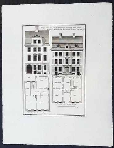
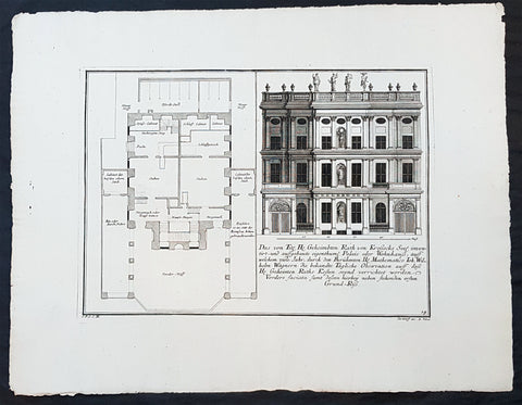
1740 Wolff & Corvinus Antique Arch Print Plans of Residential Houses in Berlin
- Title : Zwey von Hr. von Grünenberg inventirte und gebaute Burgerl. Wohnhäusser mit ihren Faciaten u. Grundrissen
- Ref #: 93450
- Size: 19in x 12 1/2in (490mm x 335mm)
- Date : 1740
- Condition: (A+) Fine Condition
Description:
This large rare, original copper-plate engraved antique architectural print plans of Berlin Houses - plate No. 12 of 16 - by Johann August Corvinus 1683 - 1738, after Andreas Mayers 1716 - 1782, was published in Eigentliche Abbildung des Prächtigen Königl. Lust Schlosses Charlottenburg, eine Meile von Berlin, sambt dem darhinden im Walde gelegenen schönen Lust Garten
(Set of 16 numbered plates, the first with the title, with plans and views of the buildings and gardens at Charlottenburg, the palace of the King of Prussia on the outskirts of Berlin.) by Jeremias Wolff Erben in 1740.
General Definitions:
Paper thickness and quality: - Heavy and stable
Paper color : - off white
Age of map color: -
Colors used: -
General color appearance: -
Paper size: - 19in x 12 1/2in (490mm x 335mm)
Plate size: - 14 1/2in x 10 1/2in (370mm x 260mm)
Margins: - Min 1in (25mm)
Imperfections:
Margins: - None
Plate area: - None
Verso: - None
Background:
Berlin straddles the banks of the River Spree, which flows into the River Havel (a tributary of the River Elbe) in the western borough of Spandau. Among the citys main topographical features are the many lakes in the western and southeastern boroughs formed by the Spree, Havel, and Dahme rivers (the largest of which is Lake Müggelsee). Due to its location in the European Plain, Berlin is influenced by a temperate seasonal climate. About one-third of the citys area is composed of forests, parks, gardens, rivers, canals and lakes. The city lies in the Central German dialect area, the Berlin dialect being a variant of the Lusatian-New Marchian dialects.
First documented in the 13th century and situated at the crossing of two important historic trade routes, Berlin became the capital of the Margraviate of Brandenburg (1417–1701), the Kingdom of Prussia (1701–1918), the German Empire (1871–1918), the Weimar Republic (1919–1933), and the Third Reich (1933–1945). Berlin in the 1920s was the third-largest municipality in the world. After World War II and its subsequent occupation by the victorious countries, the city was divided; West Berlin became a de facto West German exclave, surrounded by the Berlin Wall (1961–1989) and East German territory. East Berlin was declared capital of East Germany, while Bonn became the West German capital. Following German reunification in 1990, Berlin once again became the capital of all of Germany.
The Thirty Years War between 1618 and 1648 devastated Berlin. One third of its houses were damaged or destroyed, and the city lost half of its population. Frederick William, known as the Great Elector, who had succeeded his father George William as ruler in 1640, initiated a policy of promoting immigration and religious tolerance. With the Edict of Potsdam in 1685, Frederick William offered asylum to the French Huguenots.
By 1700, approximately 30 percent of Berlins residents were French, because of the Huguenot immigration. Many other immigrants came from Bohemia, Poland, and Salzburg.
Since 1618, the Margraviate of Brandenburg had been in personal union with the Duchy of Prussia. In 1701, the dual state formed the Kingdom of Prussia, as Frederick III, Elector of Brandenburg, crowned himself as king Frederick I in Prussia. Berlin became the capital of the new Kingdom, replacing Königsberg. This was a successful attempt to centralise the capital in the very far-flung state, and it was the first time the city began to grow. In 1709, Berlin merged with the four cities of Cölln, Friedrichswerder, Friedrichstadt and Dorotheenstadt under the name Berlin, Haupt- und Residenzstadt Berlin.
In 1740, Frederick II, known as Frederick the Great (1740–1786), came to power. Under the rule of Frederick II, Berlin became a center of the Enlightenment, but also, was briefly occupied during the Seven Years War by the Russian army. Following Frances victory in the War of the Fourth Coalition, Napoleon Bonaparte marched into Berlin in 1806, but granted self-government to the city. In 1815, the city became part of the new Province of Brandenburg.
The Industrial Revolution transformed Berlin during the 19th century; the citys economy and population expanded dramatically, and it became the main railway hub and economic centre of Germany. Additional suburbs soon developed and increased the area and population of Berlin. In 1861, neighbouring suburbs including Wedding, Moabit and several others were incorporated into Berlin. In 1871, Berlin became capital of the newly founded German Empire. In 1881, it became a city district separate from Brandenburg.
Wolff, Jeremais 1663 - 1724
Wolff was an German engraver and publisher. Born in Augsburg, he originally trained as a clock and automat maker, later changing course and opening a small copperplate engraving shop. His success was impressive and became one of the largest European art, print & map publishers in the first half of the 18th century. Wolff employed some of the best engravers of the time and although not an engraver himself, only Wolffs name was recorded on the engravings. Many of his engravers went uncredited for their work. In 1710 Wolff was one of the founder member of the Empire State Academy of Arts in Augsburg.
After his death in 1724, Wolffs publishing business was inherited by his sons and son-in-law, Johann Balthasar Probst (1673–1750) a notable engraver at the time. The firm continued on in Augsburg under the name Jeremias Wolff Erben.
Together with the Nuremberg copperplate engraver Paul Decker , Wolff published a series of engravings showing the war successes of Prince Eugene of Savoy in Italy , southern Germany and the Spanish Netherlands, during the War of the Spanish Succession . The prints are exhibited in the Museum of Military History, in Vienna .
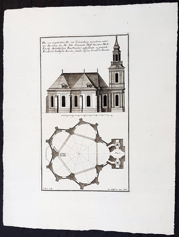
1740 Wolff & Corvinus Antique Arch. Print Jerusalem Church Friedrichstadt.Berlin
- Title : Die von vorgedachten Hr. von Grünenberg invendierte, unter der Direction des Hr. Ioh. Simonetti Hoff Stucator Hoch-Fürstl. Anhaltischen BauMeister aufgebaute so genande Friderich Stättische Kirche sampt dessen Grund u. Faciata.
- Ref #: 93458
- Size: 19in x 12 1/2in (490mm x 335mm)
- Date : 1740
- Condition: (A+) Fine Condition
Description:
This large rare, original copper-plate engraved antique architectural print of the Parochialkirche (literally the Reformed parochial church) in the Mitte suburb of Berlin - plate No. 7 of 16 - by Johann August Corvinus 1683 - 1738, after Andreas Mayers 1716 - 1782, was published in Eigentliche Abbildung des Prächtigen Königl. Lust Schlosses Charlottenburg, eine Meile von Berlin, sambt dem darhinden im Walde gelegenen schönen Lust Garten
(Set of 16 numbered plates, the first with the title, with plans and views of the buildings and gardens at Charlottenburg, the palace of the King of Prussia on the outskirts of Berlin.) by Jeremias Wolff Erben in 1740.
General Definitions:
Paper thickness and quality: - Heavy and stable
Paper color : - off white
Age of map color: -
Colors used: -
General color appearance: -
Paper size: - 19in x 12 1/2in (490mm x 335mm)
Plate size: - 14 1/2in x 10 1/2in (370mm x 260mm)
Margins: - Min 1in (25mm)
Imperfections:
Margins: - None
Plate area: - None
Verso: - None
Background:
Berlin straddles the banks of the River Spree, which flows into the River Havel (a tributary of the River Elbe) in the western borough of Spandau. Among the citys main topographical features are the many lakes in the western and southeastern boroughs formed by the Spree, Havel, and Dahme rivers (the largest of which is Lake Müggelsee). Due to its location in the European Plain, Berlin is influenced by a temperate seasonal climate. About one-third of the citys area is composed of forests, parks, gardens, rivers, canals and lakes. The city lies in the Central German dialect area, the Berlin dialect being a variant of the Lusatian-New Marchian dialects.
First documented in the 13th century and situated at the crossing of two important historic trade routes, Berlin became the capital of the Margraviate of Brandenburg (1417–1701), the Kingdom of Prussia (1701–1918), the German Empire (1871–1918), the Weimar Republic (1919–1933), and the Third Reich (1933–1945). Berlin in the 1920s was the third-largest municipality in the world. After World War II and its subsequent occupation by the victorious countries, the city was divided; West Berlin became a de facto West German exclave, surrounded by the Berlin Wall (1961–1989) and East German territory. East Berlin was declared capital of East Germany, while Bonn became the West German capital. Following German reunification in 1990, Berlin once again became the capital of all of Germany.
The Thirty Years War between 1618 and 1648 devastated Berlin. One third of its houses were damaged or destroyed, and the city lost half of its population. Frederick William, known as the Great Elector, who had succeeded his father George William as ruler in 1640, initiated a policy of promoting immigration and religious tolerance. With the Edict of Potsdam in 1685, Frederick William offered asylum to the French Huguenots.
By 1700, approximately 30 percent of Berlins residents were French, because of the Huguenot immigration. Many other immigrants came from Bohemia, Poland, and Salzburg.
Since 1618, the Margraviate of Brandenburg had been in personal union with the Duchy of Prussia. In 1701, the dual state formed the Kingdom of Prussia, as Frederick III, Elector of Brandenburg, crowned himself as king Frederick I in Prussia. Berlin became the capital of the new Kingdom, replacing Königsberg. This was a successful attempt to centralise the capital in the very far-flung state, and it was the first time the city began to grow. In 1709, Berlin merged with the four cities of Cölln, Friedrichswerder, Friedrichstadt and Dorotheenstadt under the name Berlin, Haupt- und Residenzstadt Berlin.
In 1740, Frederick II, known as Frederick the Great (1740–1786), came to power. Under the rule of Frederick II, Berlin became a center of the Enlightenment, but also, was briefly occupied during the Seven Years War by the Russian army. Following Frances victory in the War of the Fourth Coalition, Napoleon Bonaparte marched into Berlin in 1806, but granted self-government to the city. In 1815, the city became part of the new Province of Brandenburg.
The Industrial Revolution transformed Berlin during the 19th century; the citys economy and population expanded dramatically, and it became the main railway hub and economic centre of Germany. Additional suburbs soon developed and increased the area and population of Berlin. In 1861, neighbouring suburbs including Wedding, Moabit and several others were incorporated into Berlin. In 1871, Berlin became capital of the newly founded German Empire. In 1881, it became a city district separate from Brandenburg.
Wolff, Jeremais 1663 - 1724
Wolff was an German engraver and publisher. Born in Augsburg, he originally trained as a clock and automat maker, later changing course and opening a small copperplate engraving shop. His success was impressive and became one of the largest European art, print & map publishers in the first half of the 18th century. Wolff employed some of the best engravers of the time and although not an engraver himself, only Wolffs name was recorded on the engravings. Many of his engravers went uncredited for their work. In 1710 Wolff was one of the founder member of the Empire State Academy of Arts in Augsburg.
After his death in 1724, Wolffs publishing business was inherited by his sons and son-in-law, Johann Balthasar Probst (1673–1750) a notable engraver at the time. The firm continued on in Augsburg under the name Jeremias Wolff Erben.
Together with the Nuremberg copperplate engraver Paul Decker , Wolff published a series of engravings showing the war successes of Prince Eugene of Savoy in Italy , southern Germany and the Spanish Netherlands, during the War of the Spanish Succession . The prints are exhibited in the Museum of Military History, in Vienna .
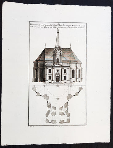
1740 Wolff & Corvinus Antique Arch. Print of the Parochialkirche in Mitte Berlin
- Title : Vordere faciata nebst dem halben Grund Riß der vorigen Parochial-Kirche mit verändertem Thurn wie solcher dermahlen sich würklich presentiert. Frontriß, darunter der halbe Grundriß.
- Ref #: 93459
- Size: 19in x 12 1/2in (490mm x 335mm)
- Date : 1740
- Condition: (A+) Fine Condition
Description:
This large rare, original copper-plate engraved antique architectural print of the Parochialkirche (literally the Reformed parochial church) in the Mitte suburb of Berlin - plate No. 6 of 16 - by Johann August Corvinus 1683 - 1738, after Andreas Mayers 1716 - 1782, was published in Eigentliche Abbildung des Prächtigen Königl. Lust Schlosses Charlottenburg, eine Meile von Berlin, sambt dem darhinden im Walde gelegenen schönen Lust Garten.
(Set of 16 numbered plates, the first with the title, with plans and views of the buildings and gardens at Charlottenburg, the palace of the King of Prussia on the outskirts of Berlin.) by Jeremias Wolff Erben in 1740.
General Definitions:
Paper thickness and quality: - Heavy and stable
Paper color : - off white
Age of map color: -
Colors used: -
General color appearance: -
Paper size: - 19in x 12 1/2in (490mm x 335mm)
Plate size: - 14 1/2in x 10 1/2in (370mm x 260mm)
Margins: - Min 1in (25mm)
Imperfections:
Margins: - None
Plate area: - None
Verso: - None
Background:
Berlin straddles the banks of the River Spree, which flows into the River Havel (a tributary of the River Elbe) in the western borough of Spandau. Among the citys main topographical features are the many lakes in the western and southeastern boroughs formed by the Spree, Havel, and Dahme rivers (the largest of which is Lake Müggelsee). Due to its location in the European Plain, Berlin is influenced by a temperate seasonal climate. About one-third of the citys area is composed of forests, parks, gardens, rivers, canals and lakes. The city lies in the Central German dialect area, the Berlin dialect being a variant of the Lusatian-New Marchian dialects.
First documented in the 13th century and situated at the crossing of two important historic trade routes, Berlin became the capital of the Margraviate of Brandenburg (1417–1701), the Kingdom of Prussia (1701–1918), the German Empire (1871–1918), the Weimar Republic (1919–1933), and the Third Reich (1933–1945). Berlin in the 1920s was the third-largest municipality in the world. After World War II and its subsequent occupation by the victorious countries, the city was divided; West Berlin became a de facto West German exclave, surrounded by the Berlin Wall (1961–1989) and East German territory. East Berlin was declared capital of East Germany, while Bonn became the West German capital. Following German reunification in 1990, Berlin once again became the capital of all of Germany.
The Thirty Years War between 1618 and 1648 devastated Berlin. One third of its houses were damaged or destroyed, and the city lost half of its population. Frederick William, known as the Great Elector, who had succeeded his father George William as ruler in 1640, initiated a policy of promoting immigration and religious tolerance. With the Edict of Potsdam in 1685, Frederick William offered asylum to the French Huguenots.
By 1700, approximately 30 percent of Berlins residents were French, because of the Huguenot immigration. Many other immigrants came from Bohemia, Poland, and Salzburg.
Since 1618, the Margraviate of Brandenburg had been in personal union with the Duchy of Prussia. In 1701, the dual state formed the Kingdom of Prussia, as Frederick III, Elector of Brandenburg, crowned himself as king Frederick I in Prussia. Berlin became the capital of the new Kingdom, replacing Königsberg. This was a successful attempt to centralise the capital in the very far-flung state, and it was the first time the city began to grow. In 1709, Berlin merged with the four cities of Cölln, Friedrichswerder, Friedrichstadt and Dorotheenstadt under the name Berlin, Haupt- und Residenzstadt Berlin.
In 1740, Frederick II, known as Frederick the Great (1740–1786), came to power. Under the rule of Frederick II, Berlin became a center of the Enlightenment, but also, was briefly occupied during the Seven Years War by the Russian army. Following Frances victory in the War of the Fourth Coalition, Napoleon Bonaparte marched into Berlin in 1806, but granted self-government to the city. In 1815, the city became part of the new Province of Brandenburg.
The Industrial Revolution transformed Berlin during the 19th century; the citys economy and population expanded dramatically, and it became the main railway hub and economic centre of Germany. Additional suburbs soon developed and increased the area and population of Berlin. In 1861, neighbouring suburbs including Wedding, Moabit and several others were incorporated into Berlin. In 1871, Berlin became capital of the newly founded German Empire. In 1881, it became a city district separate from Brandenburg.
Wolff, Jeremais 1663 - 1724
Wolff was an German engraver and publisher. Born in Augsburg, he originally trained as a clock and automat maker, later changing course and opening a small copperplate engraving shop. His success was impressive and became one of the largest European art, print & map publishers in the first half of the 18th century. Wolff employed some of the best engravers of the time and although not an engraver himself, only Wolffs name was recorded on the engravings. Many of his engravers went uncredited for their work. In 1710 Wolff was one of the founder member of the Empire State Academy of Arts in Augsburg.
After his death in 1724, Wolffs publishing business was inherited by his sons and son-in-law, Johann Balthasar Probst (1673–1750) a notable engraver at the time. The firm continued on in Augsburg under the name Jeremias Wolff Erben.
Together with the Nuremberg copperplate engraver Paul Decker , Wolff published a series of engravings showing the war successes of Prince Eugene of Savoy in Italy , southern Germany and the Spanish Netherlands, during the War of the Spanish Succession . The prints are exhibited in the Museum of Military History, in Vienna .
1740 Wolff & Corvinus Antique Architectural Print Buildings, Gardens Berlin - No. 14
- Title : Das von Title Hr. Geheimbten Rath von Krossecks Seel. inventirt - und aussgebaute
- Ref #: 93448
- Size: 19in x 12 1/2in (490mm x 335mm)
- Date : 1740
- Condition: (A+) Fine Condition
Description:
This large fine, original copper-plate engraved antique architectural print of buildings & gardens in the Charlottenburg suburb of Berlin & Charlottenburg Palace, - plate No. 14 of 16 - by Johann August Corvinus 1683 - 1738, after Andreas Mayers 1716 - 1782, was published in Eigentliche Abbildung des Prächtigen Königl. Lust Schlosses Charlottenburg, eine Meile von Berlin, sambt dem darhinden im Walde gelegenen schönen Lust Garten
(Set of 16 numbered plates, the first with the title, with plans and views of the buildings and gardens at Charlottenburg, the palace of the King of Prussia on the outskirts of Berlin.) by Jeremias Wolff Erben in 1740.
General Definitions:
Paper thickness and quality: - Heavy and stable
Paper color : - off white
Age of map color: -
Colors used: -
General color appearance: -
Paper size: - 19in x 12 1/2in (490mm x 335mm)
Plate size: - 14 1/2in x 10 1/2in (370mm x 260mm)
Margins: - Min 1in (25mm)
Imperfections:
Margins: - None
Plate area: - None
Verso: - None
Background:
Charlottenburg is an affluent locality of Berlin within the borough of Charlottenburg-Wilmersdorf. Established as a town in 1705 and named after late Sophia Charlotte of Hanover, Queen consort of Prussia, it is best known for Charlottenburg Palace, the largest surviving royal palace in Berlin, and the adjacent museums.
Charlottenburg is located in Berlins inner city, west of the Großer Tiergarten park. Its historic core, the former village green of Alt Lietzow, is situated on the southern shore of the Spree River running through the Berlin glacial valley. The Straße des 17. Juni road, former Charlottenburger Chaussee, which runs eastwards from Charlottenburg Gate through the Tiergarten park to Brandenburg Gate, connects Charlottenburg with the historic centre of Berlin-Mitte.
In the north and west, the Berlin Ringbahn and the Bundesautobahn 100 (Stadtring) mark the border with the Charlottenburg-Nord and Westend suburbs. Adjacent in the south is the territory of Wilmersdorf. Charlottenburg also borders on the district of Halensee in the southwest, as well as on Moabit, Hansaviertel and Tiergarten (all part of the Mitte borough) in the east and on Schöneberg in the southeast.
In 1695, Sophia Charlotte of Hanover received Lietzow from her husband, Elector Frederick III of Brandenburg, in exchange for her estates in Caputh and Langerwisch near Potsdam. Frederick had a summer residence built there for Sophie Charlotte by the architect Johann Arnold Nering between 1695 and 1699. After he had crowned himself Frederick I, King in Prussia, the Lützenburg castle was extended into a stately building with a cour dhonneur. The Swedish master builder Johann Friedrich Eosander supervised this work. Sophie Charlotte died in February 1705; shortly afterwards the settlement facing the palace was called Charlottenburg - the palace itself became Schloss Charlottenburg - and chartered as a town on April 5, 1705. The king served as the towns mayor until the historic village of Lietzow was incorporated into Charlottenburg in 1720.
Fredericks successor as king, Frederick William I of Prussia, rarely stayed at the palace, which depressed the small town of Charlottenburg. Frederick William even tried to revoke the towns privileges. With the coronation of his successor Frederick II in 1740 the towns significance increased, as regular celebrations again took place at the palace. Between 1740 and 1747 Georg Wenzeslaus von Knobelsdorff built the eastern New Wing as Fredericks residence. Later, Frederick II preferred the palace of Sanssouci, which he had partly designed himself.
When Frederick II died in 1786, his nephew Frederick William II succeeded him, and Charlottenburg became the favourite royal residence, and remained so for his son and successor Frederick William III (reigned 1797-1840). After the defeat of the Prussian army at Jena in 1806, the French occupied Berlin. Napoleon took over the palace, while his troops made a camp nearby. Charlottenburg became part of the new Prussian Province of Brandenburg in 1815 after the Napoleonic Wars.
In the late 18th century, Charlottenburgs development did not depend only on the crown. The town became a recreational area for the expanding city of Berlin. Its first true inn opened in the 1770s, in the street then called Berliner Straße (now Otto-Suhr-Allee), and many other inns and beer gardens were to follow, popular for weekend parties especially. Berliners seeking leisure and entertainment came by boat, by carriage and later by horse-drawn trams, above all to a large amusement park at the shore of the Spree river called Flora, that went into bankruptcy in 1904.
From the 1860s on the wealthy Bourgeoisie of Berlin discovered Charlottenburg as a residential area, among the first were Gerson von Bleichröder and Ernst Werner von Siemens, who had a villa built in the Berliner Straße in 1862. At the same time industrial companies like Siemens & Halske and Schering erected large factories in the north-east, at the border with the Moabit district of Berlin. In 1877 Charlottenburg received town privileges and until World War I saw an enormous increase of population with 100,000 inhabitants as of 1893 and a population of 306,000 in 1920, being the second largest city within the Province of Brandenburg, after Berlin. In the course of industrialization in the 19th century, much of Charlottenburg was incorporated in a network of streets laid out in the Hobrecht-Plan in an area that came to be known architecturally as the Wilhelmine Ring.
Wolff, Jeremais 1663 - 1724
Wolff was an German engraver and publisher. Born in Augsburg, he originally trained as a clock and automat maker, later changing course and opening a small copperplate engraving shop. His success was impressive and became one of the largest European art, print & map publishers in the first half of the 18th century. Wolff employed some of the best engravers of the time and although not an engraver himself, only Wolffs name was recorded on the engravings. Many of his engravers went uncredited for their work. In 1710 Wolff was one of the founder member of the Empire State Academy of Arts in Augsburg.
After his death in 1724, Wolffs publishing business was inherited by his sons and son-in-law, Johann Balthasar Probst (1673–1750) a notable engraver at the time. The firm continued on in Augsburg under the name Jeremias Wolff Erben.
Together with the Nuremberg copperplate engraver Paul Decker , Wolff published a series of engravings showing the war successes of Prince Eugene of Savoy in Italy , southern Germany and the Spanish Netherlands, during the War of the Spanish Succession . The prints are exhibited in the Museum of Military History, in Vienna .
1740 Wolff & Corvinus Antique Architectural Print Charlottenburg Palace, Gardens
- Title : Haupt Hof Grund Riss dess Marstalls...Jeremais Wolff exc Aug. Vind
- Ref #: 93446
- Size: 19in x 12 1/2in (490mm x 335mm)
- Date : 1740
- Condition: (A+) Fine Condition
Description:
This large fine, original copper-plate engraved antique architectural print of buildings in the Charlottenburg suburb of Berlin & Charlottenburg Palace, - plate No. 4 of 16 - by Johann August Corvinus 1683 - 1738, after Andreas Mayers 1716 - 1782, was published in Eigentliche Abbildung des Prächtigen Königl. Lust Schlosses Charlottenburg, eine Meile von Berlin, sambt dem darhinden im Walde gelegenen schönen Lust Garten
(Set of 16 numbered plates, the first with the title, with plans and views of the buildings and gardens at Charlottenburg, the palace of the King of Prussia on the outskirts of Berlin.) by Jeremias Wolff Erben in 1740.
General Definitions:
Paper thickness and quality: - Heavy and stable
Paper color : - off white
Age of map color: -
Colors used: -
General color appearance: -
Paper size: - 19in x 12 1/2in (490mm x 335mm)
Plate size: - 15 1/2in x 10in (385mm x 255mm)
Margins: - Min 1in (25mm)
Imperfections:
Margins: - None
Plate area: - None
Verso: - None
Background:
Charlottenburg is an affluent locality of Berlin within the borough of Charlottenburg-Wilmersdorf. Established as a town in 1705 and named after late Sophia Charlotte of Hanover, Queen consort of Prussia, it is best known for Charlottenburg Palace, the largest surviving royal palace in Berlin, and the adjacent museums.
Charlottenburg is located in Berlins inner city, west of the Großer Tiergarten park. Its historic core, the former village green of Alt Lietzow, is situated on the southern shore of the Spree River running through the Berlin glacial valley. The Straße des 17. Juni road, former Charlottenburger Chaussee, which runs eastwards from Charlottenburg Gate through the Tiergarten park to Brandenburg Gate, connects Charlottenburg with the historic centre of Berlin-Mitte.
In the north and west, the Berlin Ringbahn and the Bundesautobahn 100 (Stadtring) mark the border with the Charlottenburg-Nord and Westend suburbs. Adjacent in the south is the territory of Wilmersdorf. Charlottenburg also borders on the district of Halensee in the southwest, as well as on Moabit, Hansaviertel and Tiergarten (all part of the Mitte borough) in the east and on Schöneberg in the southeast.
In 1695, Sophia Charlotte of Hanover received Lietzow from her husband, Elector Frederick III of Brandenburg, in exchange for her estates in Caputh and Langerwisch near Potsdam. Frederick had a summer residence built there for Sophie Charlotte by the architect Johann Arnold Nering between 1695 and 1699. After he had crowned himself Frederick I, King in Prussia, the Lützenburg castle was extended into a stately building with a cour dhonneur. The Swedish master builder Johann Friedrich Eosander supervised this work. Sophie Charlotte died in February 1705; shortly afterwards the settlement facing the palace was called Charlottenburg - the palace itself became Schloss Charlottenburg - and chartered as a town on April 5, 1705. The king served as the towns mayor until the historic village of Lietzow was incorporated into Charlottenburg in 1720.
Fredericks successor as king, Frederick William I of Prussia, rarely stayed at the palace, which depressed the small town of Charlottenburg. Frederick William even tried to revoke the towns privileges. With the coronation of his successor Frederick II in 1740 the towns significance increased, as regular celebrations again took place at the palace. Between 1740 and 1747 Georg Wenzeslaus von Knobelsdorff built the eastern New Wing as Fredericks residence. Later, Frederick II preferred the palace of Sanssouci, which he had partly designed himself.
When Frederick II died in 1786, his nephew Frederick William II succeeded him, and Charlottenburg became the favourite royal residence, and remained so for his son and successor Frederick William III (reigned 1797-1840). After the defeat of the Prussian army at Jena in 1806, the French occupied Berlin. Napoleon took over the palace, while his troops made a camp nearby. Charlottenburg became part of the new Prussian Province of Brandenburg in 1815 after the Napoleonic Wars.
In the late 18th century, Charlottenburgs development did not depend only on the crown. The town became a recreational area for the expanding city of Berlin. Its first true inn opened in the 1770s, in the street then called Berliner Straße (now Otto-Suhr-Allee), and many other inns and beer gardens were to follow, popular for weekend parties especially. Berliners seeking leisure and entertainment came by boat, by carriage and later by horse-drawn trams, above all to a large amusement park at the shore of the Spree river called Flora, that went into bankruptcy in 1904.
From the 1860s on the wealthy Bourgeoisie of Berlin discovered Charlottenburg as a residential area, among the first were Gerson von Bleichröder and Ernst Werner von Siemens, who had a villa built in the Berliner Straße in 1862. At the same time industrial companies like Siemens & Halske and Schering erected large factories in the north-east, at the border with the Moabit district of Berlin. In 1877 Charlottenburg received town privileges and until World War I saw an enormous increase of population with 100,000 inhabitants as of 1893 and a population of 306,000 in 1920, being the second largest city within the Province of Brandenburg, after Berlin. In the course of industrialization in the 19th century, much of Charlottenburg was incorporated in a network of streets laid out in the Hobrecht-Plan in an area that came to be known architecturally as the Wilhelmine Ring.
Wolff, Jeremais 1663 - 1724
Wolff was an German engraver and publisher. Born in Augsburg, he originally trained as a clock and automat maker, later changing course and opening a small copperplate engraving shop. His success was impressive and became one of the largest European art, print & map publishers in the first half of the 18th century. Wolff employed some of the best engravers of the time and although not an engraver himself, only Wolffs name was recorded on the engravings. Many of his engravers went uncredited for their work. In 1710 Wolff was one of the founder member of the Empire State Academy of Arts in Augsburg.
After his death in 1724, Wolffs publishing business was inherited by his sons and son-in-law, Johann Balthasar Probst (1673–1750) a notable engraver at the time. The firm continued on in Augsburg under the name Jeremias Wolff Erben.
Together with the Nuremberg copperplate engraver Paul Decker , Wolff published a series of engravings showing the war successes of Prince Eugene of Savoy in Italy , southern Germany and the Spanish Netherlands, during the War of the Spanish Succession . The prints are exhibited in the Museum of Military History, in Vienna .
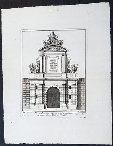
1740 Wolff & Corvinus Antique Architectural Print of Berlin Gate, Leipziger Tor
- Title : Das von dem Herrn Baumeister Nering Seel. ausgefuhrte so genandte Leipziger Statt Thor in Berlin
- Ref #: 93452
- Size: 19in x 12 1/2in (490mm x 335mm)
- Date : 1740
- Condition: (A+) Fine Condition
Description:
This large fine, original copper-plate engraved antique architectural print of buildings & gardens in 17th & 18th century Berlin - plate No. 3 of 16 - by Johann August Corvinus 1683 - 1738, after Andreas Mayers 1716 - 1782, was published in Eigentliche Abbildung des Prächtigen Königl. Lust Schlosses Charlottenburg, eine Meile von Berlin, sambt dem darhinden im Walde gelegenen schönen Lust Garten
(Set of 16 numbered plates, the first with the title, with plans and views of the buildings and gardens at Charlottenburg, the palace of the King of Prussia on the outskirts of Berlin.) by Jeremias Wolff Erben in 1740.
General Definitions:
Paper thickness and quality: - Heavy and stable
Paper color : - off white
Age of map color: -
Colors used: -
General color appearance: -
Paper size: - 19in x 12 1/2in (490mm x 335mm)
Plate size: - 14 1/2in x 10 1/2in (370mm x 260mm)
Margins: - Min 1in (25mm)
Imperfections:
Margins: - None
Plate area: - None
Verso: - None
Background:
Berlin straddles the banks of the River Spree, which flows into the River Havel (a tributary of the River Elbe) in the western borough of Spandau. Among the citys main topographical features are the many lakes in the western and southeastern boroughs formed by the Spree, Havel, and Dahme rivers (the largest of which is Lake Müggelsee). Due to its location in the European Plain, Berlin is influenced by a temperate seasonal climate. About one-third of the citys area is composed of forests, parks, gardens, rivers, canals and lakes. The city lies in the Central German dialect area, the Berlin dialect being a variant of the Lusatian-New Marchian dialects.
First documented in the 13th century and situated at the crossing of two important historic trade routes, Berlin became the capital of the Margraviate of Brandenburg (1417–1701), the Kingdom of Prussia (1701–1918), the German Empire (1871–1918), the Weimar Republic (1919–1933), and the Third Reich (1933–1945). Berlin in the 1920s was the third-largest municipality in the world. After World War II and its subsequent occupation by the victorious countries, the city was divided; West Berlin became a de facto West German exclave, surrounded by the Berlin Wall (1961–1989) and East German territory. East Berlin was declared capital of East Germany, while Bonn became the West German capital. Following German reunification in 1990, Berlin once again became the capital of all of Germany.
The Thirty Years War between 1618 and 1648 devastated Berlin. One third of its houses were damaged or destroyed, and the city lost half of its population. Frederick William, known as the Great Elector, who had succeeded his father George William as ruler in 1640, initiated a policy of promoting immigration and religious tolerance. With the Edict of Potsdam in 1685, Frederick William offered asylum to the French Huguenots.
By 1700, approximately 30 percent of Berlins residents were French, because of the Huguenot immigration. Many other immigrants came from Bohemia, Poland, and Salzburg.
Since 1618, the Margraviate of Brandenburg had been in personal union with the Duchy of Prussia. In 1701, the dual state formed the Kingdom of Prussia, as Frederick III, Elector of Brandenburg, crowned himself as king Frederick I in Prussia. Berlin became the capital of the new Kingdom, replacing Königsberg. This was a successful attempt to centralise the capital in the very far-flung state, and it was the first time the city began to grow. In 1709, Berlin merged with the four cities of Cölln, Friedrichswerder, Friedrichstadt and Dorotheenstadt under the name Berlin, Haupt- und Residenzstadt Berlin.
In 1740, Frederick II, known as Frederick the Great (1740–1786), came to power. Under the rule of Frederick II, Berlin became a center of the Enlightenment, but also, was briefly occupied during the Seven Years War by the Russian army. Following Frances victory in the War of the Fourth Coalition, Napoleon Bonaparte marched into Berlin in 1806, but granted self-government to the city. In 1815, the city became part of the new Province of Brandenburg.
The Industrial Revolution transformed Berlin during the 19th century; the citys economy and population expanded dramatically, and it became the main railway hub and economic centre of Germany. Additional suburbs soon developed and increased the area and population of Berlin. In 1861, neighbouring suburbs including Wedding, Moabit and several others were incorporated into Berlin. In 1871, Berlin became capital of the newly founded German Empire. In 1881, it became a city district separate from Brandenburg.
Wolff, Jeremais 1663 - 1724
Wolff was an German engraver and publisher. Born in Augsburg, he originally trained as a clock and automat maker, later changing course and opening a small copperplate engraving shop. His success was impressive and became one of the largest European art, print & map publishers in the first half of the 18th century. Wolff employed some of the best engravers of the time and although not an engraver himself, only Wolffs name was recorded on the engravings. Many of his engravers went uncredited for their work. In 1710 Wolff was one of the founder member of the Empire State Academy of Arts in Augsburg.
After his death in 1724, Wolffs publishing business was inherited by his sons and son-in-law, Johann Balthasar Probst (1673–1750) a notable engraver at the time. The firm continued on in Augsburg under the name Jeremias Wolff Erben.
Together with the Nuremberg copperplate engraver Paul Decker , Wolff published a series of engravings showing the war successes of Prince Eugene of Savoy in Italy , southern Germany and the Spanish Netherlands, during the War of the Spanish Succession . The prints are exhibited in the Museum of Military History, in Vienna .
1740 Wolff & Corvinus Antique Architectural Print Parochialkirche, Mitte, Berlin
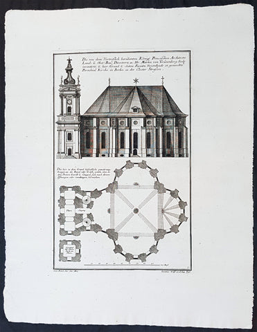
- Title : Die Von dem Vortreslich beruhmten Konigl. Preusichen Architect Land u. Ober Bau Directorn etc. Hr. Martin von Grunenberg Seel. inventirte, u. hier Grund u. Seiten Faciata Vorstellende so genandte Parochial Kirche in Berlin in der Closter Strassen
- Ref #: 93451
- Size: 19in x 12 1/2in (490mm x 335mm)
- Date : 1740
- Condition: (A+) Fine Condition
Description:
This large rare, original copper-plate engraved antique architectural print of the Parochialkirche (literally the Reformed parochial church) in the Mitte suburb of Berlin - plate No. 5 of 16 - by Johann August Corvinus 1683 - 1738, after Andreas Mayers 1716 - 1782, was published in Eigentliche Abbildung des Prächtigen Königl. Lust Schlosses Charlottenburg, eine Meile von Berlin, sambt dem darhinden im Walde gelegenen schönen Lust Garten
(Set of 16 numbered plates, the first with the title, with plans and views of the buildings and gardens at Charlottenburg, the palace of the King of Prussia on the outskirts of Berlin.) by Jeremias Wolff Erben in 1740.
General Definitions:
Paper thickness and quality: - Heavy and stable
Paper color : - off white
Age of map color: -
Colors used: -
General color appearance: -
Paper size: - 19in x 12 1/2in (490mm x 335mm)
Plate size: - 14 1/2in x 10 1/2in (370mm x 260mm)
Margins: - Min 1in (25mm)
Imperfections:
Margins: - None
Plate area: - None
Verso: - None
Background:
Berlin straddles the banks of the River Spree, which flows into the River Havel (a tributary of the River Elbe) in the western borough of Spandau. Among the citys main topographical features are the many lakes in the western and southeastern boroughs formed by the Spree, Havel, and Dahme rivers (the largest of which is Lake Müggelsee). Due to its location in the European Plain, Berlin is influenced by a temperate seasonal climate. About one-third of the citys area is composed of forests, parks, gardens, rivers, canals and lakes. The city lies in the Central German dialect area, the Berlin dialect being a variant of the Lusatian-New Marchian dialects.
First documented in the 13th century and situated at the crossing of two important historic trade routes, Berlin became the capital of the Margraviate of Brandenburg (1417–1701), the Kingdom of Prussia (1701–1918), the German Empire (1871–1918), the Weimar Republic (1919–1933), and the Third Reich (1933–1945). Berlin in the 1920s was the third-largest municipality in the world. After World War II and its subsequent occupation by the victorious countries, the city was divided; West Berlin became a de facto West German exclave, surrounded by the Berlin Wall (1961–1989) and East German territory. East Berlin was declared capital of East Germany, while Bonn became the West German capital. Following German reunification in 1990, Berlin once again became the capital of all of Germany.
The Thirty Years War between 1618 and 1648 devastated Berlin. One third of its houses were damaged or destroyed, and the city lost half of its population. Frederick William, known as the Great Elector, who had succeeded his father George William as ruler in 1640, initiated a policy of promoting immigration and religious tolerance. With the Edict of Potsdam in 1685, Frederick William offered asylum to the French Huguenots.
By 1700, approximately 30 percent of Berlins residents were French, because of the Huguenot immigration. Many other immigrants came from Bohemia, Poland, and Salzburg.
Since 1618, the Margraviate of Brandenburg had been in personal union with the Duchy of Prussia. In 1701, the dual state formed the Kingdom of Prussia, as Frederick III, Elector of Brandenburg, crowned himself as king Frederick I in Prussia. Berlin became the capital of the new Kingdom, replacing Königsberg. This was a successful attempt to centralise the capital in the very far-flung state, and it was the first time the city began to grow. In 1709, Berlin merged with the four cities of Cölln, Friedrichswerder, Friedrichstadt and Dorotheenstadt under the name Berlin, Haupt- und Residenzstadt Berlin.
In 1740, Frederick II, known as Frederick the Great (1740–1786), came to power. Under the rule of Frederick II, Berlin became a center of the Enlightenment, but also, was briefly occupied during the Seven Years War by the Russian army. Following Frances victory in the War of the Fourth Coalition, Napoleon Bonaparte marched into Berlin in 1806, but granted self-government to the city. In 1815, the city became part of the new Province of Brandenburg.
The Industrial Revolution transformed Berlin during the 19th century; the citys economy and population expanded dramatically, and it became the main railway hub and economic centre of Germany. Additional suburbs soon developed and increased the area and population of Berlin. In 1861, neighbouring suburbs including Wedding, Moabit and several others were incorporated into Berlin. In 1871, Berlin became capital of the newly founded German Empire. In 1881, it became a city district separate from Brandenburg.
Wolff, Jeremais 1663 - 1724
Wolff was an German engraver and publisher. Born in Augsburg, he originally trained as a clock and automat maker, later changing course and opening a small copperplate engraving shop. His success was impressive and became one of the largest European art, print & map publishers in the first half of the 18th century. Wolff employed some of the best engravers of the time and although not an engraver himself, only Wolffs name was recorded on the engravings. Many of his engravers went uncredited for their work. In 1710 Wolff was one of the founder member of the Empire State Academy of Arts in Augsburg.
After his death in 1724, Wolffs publishing business was inherited by his sons and son-in-law, Johann Balthasar Probst (1673–1750) a notable engraver at the time. The firm continued on in Augsburg under the name Jeremias Wolff Erben.
Together with the Nuremberg copperplate engraver Paul Decker , Wolff published a series of engravings showing the war successes of Prince Eugene of Savoy in Italy , southern Germany and the Spanish Netherlands, during the War of the Spanish Succession . The prints are exhibited in the Museum of Military History, in Vienna .