DT Valentine
1861 DT Valentine Antique Print View of Broadway New York, America in 1840
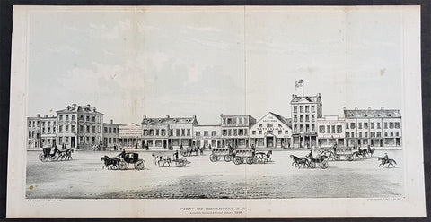
- Title : View of Broadway NY between Howard & Grans Streets, 1840
- Size: 13in x 7in (330mm x 180mm)
- Condition: (A+) Fine Condition
- Date : 1861
- Ref #: 93168
Description:
This original antique lithograph print, a view of Broadway New York in 1840, by George Hayward was published in the 1861 edition of D T Valentines Manual of the Corporation of the City of New York or Valentines Manual.
General Definitions:
Paper thickness and quality: - Heavy and stable
Paper color : - off white
Age of map color: -
Colors used: -
General color appearance: -
Paper size: - 13in x 7in (330mm x 180mm)
Plate size: - 13in x 7in (330mm x 180mm)
Margins: - Min 1/4in (5mm)
Imperfections:
Margins: - Light age toning
Plate area: - Folds as issued
Verso: - None
Background:
Manual of the Corporation of the City of New York or Valentines Manuals, published for nearly 30 years, contained hundreds of rare beautifully hand coloured contemporary and historical lithograph maps and views of New York City.
Valentine, David Thomas 1801 - 1869
As the Clerk of the Common Council of New York City, Valentine edited and published a series of books on the history and contemporary facts of New York City entitled Manual of the Corporation Of The City of New York. They became know as Valentines Manuals with updates published annually, between 1841 & 1870. Valentine used his manuals to produce some of the rarest and most important maps & views of the city of New York, some of which occasionally appear on the market. His contribution to the historical record of New York city cannot be over stated.
1869 DT Valentine Antique Print of the Proposed East River or Brooklyn Bridge NY
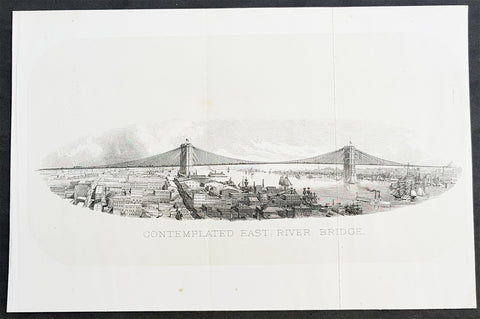
- Title : Contemplated East River Bridge
- Size: 11in x 7 1/2in (280mm x 190mm)
- Condition: (A+) Fine Condition
- Date : 1869
- Ref #: 93310
Description:
This original antique lithograph print, a view of the proposed Brooklyn Bridge in 1869 by George Hayward was published in the 1869 edition of D T Valentines Manual of the Corporation of the City of New York or Valentines Manual.
The Brooklyn Bridge started construction in 1869 and was completed fourteen years later in 1883. It was originally called the New York and Brooklyn Bridge and the East River Bridge, but it was later dubbed the Brooklyn Bridge. However, it was not named as such until the city government passed a law to that effect in 1915. Over the years, the Brooklyn Bridge has undergone several reconfigurations; it formerly carried horse-drawn vehicles and elevated railway lines, but now carries vehicular, pedestrian, and bicycle traffic. Commercial vehicles are banned from the bridge.
General Definitions:
Paper thickness and quality: - Heavy and stable
Paper color : - off white
Age of map color: -
Colors used: -
General color appearance: -
Paper size: - 11in x 7 1/2in (280mm x 190mm)
Plate size: - 11in x 7 1/2in (280mm x 190mm)
Margins: - Min 1/2in (12mm)
Imperfections:
Margins: - None
Plate area: - Folds as issued
Verso: - None
Background:
Manual of the Corporation of the City of New York or Valentines Manuals, published for nearly 30 years, contained hundreds of rare beautifully hand coloured contemporary and historical lithograph maps and views of New York City.
Valentine, David Thomas 1801 - 1869
As the Clerk of the Common Council of New York City, Valentine edited and published a series of books on the history and contemporary facts of New York City entitled Manual of the Corporation Of The City of New York. They became know as Valentines Manuals with updates published annually, between 1841 & 1870. Valentine used his manuals to produce some of the rarest and most important maps & views of the city of New York, some of which occasionally appear on the market. His contribution to the historical record of New York city cannot be over stated.
1869 DT Valentine Large Antique Map of New York City
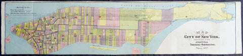
- Title : 1869 DT Valentine Large Antique Map of New York City
- Size: 39in x 9in (990mm x 230mm)
- Condition: (A+) Fine Condition
- Date : 1869
- Ref #: 93209
Description:
This large original antique lithograph map of the political divisions of New York city, printed on both sides, by George Hayward was published in the 1869 edition of D T Valentines Manual of the Corporation of the City of New York or Valentines Manual.
General Definitions:
Paper thickness and quality: - Heavy and stable
Paper color : - off white
Age of map color: - Original
Colors used: - Blue, pink, red, green, yellow
General color appearance: - Authentic
Paper size: - 39in x 9in (990mm x 230mm)
Plate size: - 39in x 9in (990mm x 230mm)
Margins: - Min 1/4in (2mm)
Imperfections:
Margins: - None
Plate area: - Folds as issued
Verso: - Folds as issued
Valentine, David Thomas 1801 - 1869
As the Clerk of the Common Council of New York City, Valentine edited and published a series of books on the history and contemporary facts of New York City entitled Manual of the Corporation Of The City of New York. They became know as Valentines Manuals with updates published annually, between 1841 & 1870. Valentine used his manuals to produce some of the rarest and most important maps & views of the city of New York, some of which occasionally appear on the market. His contribution to the historical record of New York city cannot be over stated.
1869 DT Valentine Large Antique Print, View of The Battery, Park, New York City
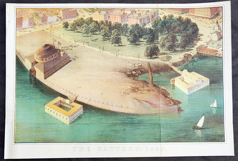
- Title : The Battery, 1869
- Size: 13 1/2in x 9 1/2in (345mm x 240mm)
- Condition: (A+) Fine Condition
- Date : 1869
- Ref #: 93210
Description:
This original antique coloured lithograph print of The Battery (Battery Park) New York City by George Hayward was published in the 1869 edition of D T Valentines Manual of the Corporation of the City of New York or Valentines Manual.
General Definitions:
Paper thickness and quality: - Heavy and stable
Paper color : - off white
Age of map color: - Original
Colors used: - Blue, pink, red, green, yellow
General color appearance: - Authentic
Paper size: - 13 1/2in x 9 1/2in (345mm x 240mm)
Plate size: - 13 1/2in x 9 1/2in (345mm x 240mm)
Margins: - Min 1/2in (12mm)
Imperfections:
Margins: - Bottom right margin extended, not affecting the image
Plate area: - Folds as issued
Verso: - Folds as issued
Background:
The Battery (formerly known as Battery Park) is a 25-acre public park located at the southern tip of Manhattan Island in New York City facing New York Harbor. It is bounded by Battery Place on the north, State Street on the east, New York Harbor to the south, and the Hudson River to the west. The park contains attractions such as an old fort named Castle Clinton; multiple monuments; and the SeaGlass Carousel. The surrounding area, known as South Ferry, contains multiple ferry terminals, including the Staten Island Ferry\'s Whitehall Terminal as well as boat launches to the Statue of Liberty National Monument.
The park and surrounding area is named for the artillery batteries that were built in the late 17th century to protect the settlement behind them. By the 1820s, the Battery had become an entertainment destination, with the conversion of Castle Clinton into a theatre venue. During the mid-19th century, the modern-day Battery Park was constructed and Castle Clinton was converted into an immigration and customs center. The Battery was commonly known as the landing point for immigrants to New York City until 1890, when the Castle Clinton immigration center was replaced by one on Ellis Island. Castle Clinton then hosted the New York Aquarium from 1896 to 1941.
Valentine, David Thomas 1801 - 1869
As the Clerk of the Common Council of New York City, Valentine edited and published a series of books on the history and contemporary facts of New York City entitled Manual of the Corporation Of The City of New York. They became know as Valentines Manuals with updates published annually, between 1841 & 1870. Valentine used his manuals to produce some of the rarest and most important maps & views of the city of New York, some of which occasionally appear on the market. His contribution to the historical record of New York city cannot be over stated.
1869 Shannon & Rogers Birds Eye View of New York City - New York Manual
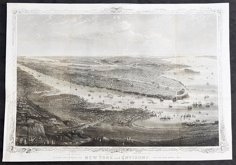
- Title : Designed and Engraved For New York and Environs. The New York Manual 1869
- Size: 16in x 12in (405mm x 275mm)
- Condition: (A+) Fine Condition
- Date : 1869
- Ref #: 93208
Description:
This original antique lithograph print of New York City by Joseph Shannon & WC Rogers in 1869 (dated) and was published in the 1869 edition of D T Valentines Manual of the Corporation of the City of New York or Valentines Manual.
General Definitions:
Paper thickness and quality: - Heavy and stable
Paper color : - off white
Age of map color: -
Colors used: -
General color appearance: -
Paper size: - 16in x 12in (405mm x 275mm)
Plate size: - 16in x 12in (405mm x 275mm)
Margins: - Min 1/2in (12mm)
Imperfections:
Margins: - Bottom right margin extended, not affecting the image
Plate area: - Folds as issued
Verso: - Folds as issued.
Background:
Rare view of the island of Manhattan, New York City by W. C. Rogers. The view depicts the entire island of Manhattan with Hoboken as well as parts of Brooklyn and Queens. Important buildings, especially churches are depicted with considerable accuracy. The harbor itself is full of sailing ships.
William C. Rogers 1860 - 1873 (active) a New York based lithographer best known for his engravings issued in conjuction with Joseph Shannons (Valentines) Manual of the Corporation for the City of New York.
Valentine, David Thomas 1801 - 1869
As the Clerk of the Common Council of New York City, Valentine edited and published a series of books on the history and contemporary facts of New York City entitled Manual of the Corporation Of The City of New York. They became know as Valentines Manuals with updates published annually, between 1841 & 1870. Valentine used his manuals to produce some of the rarest and most important maps & views of the city of New York, some of which occasionally appear on the market. His contribution to the historical record of New York city cannot be over stated.