Christoph. Cellarius
1750 Christop. Cellarius Original Antique Map of France - Gallia
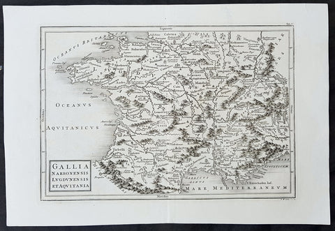
- Title : Gallia Narbonensis Lugdvnensis et Acvitania
- Size: 15in x 10 1/2in (380mm x 265mm)
- Ref #: 31353
- Date : 1750
- Condition: (A+) Fine Condition
Description:
This finely engraved original antique map of France by Christoph. Cellarius was published in the 1750 edition of Geographica Antiqua.
General Definitions:
Paper thickness and quality: - Heavy and stable
Paper color : - off white
Age of map color: -
Colors used: -
General color appearance: -
Paper size: - 15in x 10 1/2in (380mm x 265mm)
Plate size: - 12 1/2in x 8 1/2in (320mm x 215mm)
Margins: - Min 1in (25mm)
Imperfections:
Margins: - None
Plate area: - None
Verso: - None
Background:
Geographica was one of the most popular geographical publications of the 17th and 18th centuries, lasting well into the 19th century. (Ref: Tooley; M&B)
Cellarius, Christopher, 1638-1707
Christopher Cellarius (Keller) was professor of Oriental languages at Halle university and the author of numerous books including his most famous work the atlas Geographica Antiquafirst published in 1686 and being reissued with updated plates until the early 19th century.