Robert De Vaugondy (1688 - 1766) & Didier Robert de Vaugondy (c.1723–1786)
Profile :
Gilles and Didier Robert De Vaugondy were father and son, respectively, and produced their atlas, globes and maps in concert with others such as Sanson, Jaillot and Bonne amongst others. In many cases they did not use the initials of their first names when signing their maps, so it can be unclear at times who made a given map. On some maps fils. or filio. follows the name, designating its author as the son. In other instances, the authorship can be determined by the distinctive way each signed his maps: the father normally used "M.Robert," leaving off the last name, and the son, "Robert de Vaugondy." The Atlas Universal [Paris, 1757] was one of the most important 18th century atlases and one of the great achievements of the French Enlightenment.
The Vaugondy's employed strict standards for including maps in this atlas and in many cases subjected them to astronomically derived readings for latitude and longitude. Moreover, 'their frequent use of eighteenth century sources, often from the 1740s, provided their atlas with up-to-date information. While their preference was for maps that bad been surveyed in the field and maps published in the region itself, they did not hesitate to turn to older sources when more recent maps were found to be lacking." (Pedley, p. 61)
For their maps of Canada and South America, the Vaugondy's had access to sources held by the Depot de la Marine, the official French repository for maritime-related information. Like Ortelius and Mercator before them, the Vaugondy`s listed the sources of their maps, which is of incalculable benefit to anyone seeking to understand not only their maps but also those of the period.
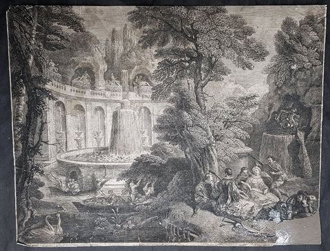
"A feature of the maps of the Atlas Universel which attracted unanimous praise from critics was the cartouches." (Pedley, p. 64) A number of artisans worked on their design and engraving; several cartouches were engraved and signed by the Haussard sisters. Among the most pictorial cartouches are the four found on maps showing the postal routes of Great Britain, France, Germany, Spain and Portugal. They depict postal carriers en route in richly detailed settings.
Robert De Vaugondy (36)
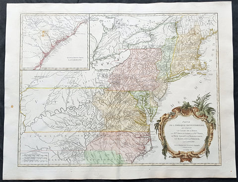
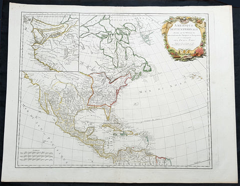
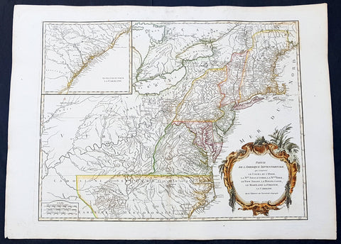
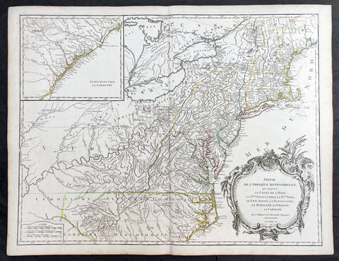
1755 Robert De Vaugondy Large Antique 1st edition Map of Colonial United States
- Title : Partie De L Amerique Septentrionale, qui Comprend Le Cours De L Ohio...1755
- Ref #: 93003
- Size: 28in x 21 1/2in (710mm x 550mm)
- Date : 1755
- Condition: (A+) Fine Condition
Description:
This large, beautifully hand coloured, scarce 1st state, original antique map of the east coast of the United States, illustrating the course of the Ohio River and stretching from New England to the Carolinas, west to the Great Lakes and south to the Mississippi - with an inset map of The Carolinas, was engraved in 1755 - the date is engraved in the title cartouche - and published by Robert Du Vaugondy in his Atlas Universal, Paris 1757.
This is one of the finest examples of this map I have seen to date. Beautiful hand colour on age toned heavy paper with original margins with a heavy dark ink denoting a very early pressing.
At the time of listing there are 2 examples of this 1st state map for sale on the web at $1600 & 1800 respectively.
General Definitions:
Paper thickness and quality: - Heavy and stable
Paper color : - off white
Age of map color: - Original
Colors used: - Blue, pink, red, green, yellow
General color appearance: - Authentic
Paper size: - 28in x 21 1/2in (710mm x 550mm)
Plate size: - 24 1/2in x 19 1/2in (620mm x 495mm)
Margins: - Min 1in (25mm)
Imperfections:
Margins: - None
Plate area: - None
Verso: - None
Background:
First state of the beautiful and early de Vaugondy map of the British colonies, based upon John Mitchell\'s great map of North America from the same year, also drawing from Lewis, Evans on the Middle British Colonies and Joshua Fry\'s and Peter Jefferson\'s map of Virginia and Maryland. The Mitchell map was the culmination of many years of British surveying in the North American Colonies and was considered one of the best maps of the continent available to Europeans and Americans in the mid-eighteenth century.
De Vaugondy\'s rendition does not copy the full scope of Mitchell\'s map but instead focuses on the colonies stretching from southern Maine to the Carolinas. In the top left corner is an inset of South Carolina and Georgia. De Vaugondy also pays special attention to the river systems and settlements. This map shows some of the earliest accurate information of the trans-Allegheny regions (the Ohio River, Kentucky, Tennessee and Parts of Ohio) and inland areas to the southeast of the Great Lakes and interior of New England. The dotted lines and outline color designate pre-Treaty of Paris (1763) information about the Ohio country.
Maine is still part of the Massachusetts Bay Colony. During this era, a dispute arose between New Hampshire and New York over who controlled the area which is now Vermont. Here, New York is shown as to contain Vermont within its borders. The outbreak of the French & Indian War (Seven Years War) briefly suspended interest in the disputed area, and it was not until 1764 that the British crown upheld New York\'s claim to Vermont. The western borders of the British Colonies extend only to the Appalachians, with the exception of \"Caroline, \"which extends slightly further west. This shows the strong French presence along the western frontier in the days leading up to the French & Indian conflict. Pennsylvania is shown to stretch north almost to Lake Ontario and encompass much of western New York.
Included is a beautiful title cartouche in the Rococo style. (Ref: Tooley; M&B)
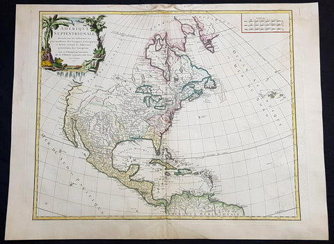
1750 Robert De Vaugondy Large Antique Map of Colonial North America, 1st Edition
- Title : Amérique Septentrionale, dressée, sur les Relations les plus modernes des Voyageurs et Navigateurs, et divisée suivant les differentes possessions des Européens...Par Le Sr Robert De Vaugondy 1750 [North America, drawn from the most recent accounts of the Voyagers and Navigators, and divided according to the different possessions of the Europeans...Robert De Vaugondy 1750
- Date : 1750
- Condition: (A+) Fine Condition
- Ref: 93048
- Size: 30 1/2in x 21 1/2in (775mm x 545mm)
Description:
This large beautifully hand coloured original 1st edition antique map of North America by Robert De Vaugondy in 1750 - dated in cartouche - was published in the 1757 edition of Atlas Universel, one of the most important atlases of the 18th century.
A beautifully executed & iconic mid 18th century antique map of the entire continent of North America, from Arctic Canada to Central America.
This map is a must for any American map collection. Beautiful original hand colour, a heavy impression (denoting an early pressing) on heavy sturdy paper with original margins, an exciting map .
General Definitions:
Paper thickness and quality: - Heavy and stable
Paper color : - off white
Age of map color: - Original
Colors used: - Yellow, green, blue, pink
General color appearance: - Authentic
Paper size: - 30 1/2in x 21 1/2in (775mm x 545mm)
Plate size: - 25in x 19 1/2in (635mm x 495mm)
Margins: - Min 1in (25mm)
Imperfections:
Margins: - None
Plate area: - None
Verso: - None
Background:
This attractive map depicts a fascinating period time in the history of North America, immediately before the French and Indian War. The British Thirteen Colonies hug the Atlantic seaboard, while the immense Gallic empire, embracing both New France (Canada) and Louisiana (the Mississippi Basin) occupy the majority of the interior of the continent. This highly detailed map labels numerous native villages and European forts in the interior of the continent. Spanish Mexico reaches all the way north to modern-day Colorado, and Baja California is shown accurately to be a peninsula, and not an island as previously thought. The Pacific Northwest remains entirely enigmatic, labelled as the Terres Inconnues. The map also depicts the islands of the Caribbean, which are shown to be in the possession of the various European powers. Vaugondy consulted several sources in devising his map including Bellins excellent rendering of the Great Lakes, and Guillame De L Isles and Jean-Baptiste D\'Anvilles maps of the Mississippi Basin. The composition is graced by an elegant title cartouche featuring a waterfall inhabited by a cayman, and framed by coulisses of palm trees accompanied by native Americans.
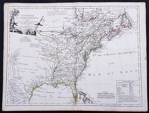
1785 De Vaugondy & Jefferson Antique Early Map of The United States of America
- Title : Etats-Unis de l'Amerique Septentrionale avec les Isles Royale, de Terre Neuve de St. Jean, l'Acadie &c. 1785 M. Robert de Vaugondy....Boudet....
- Date : 1785
- Condition: (A+) Fine Condition
- Ref: 93513
- Size: 26in x 20 1/2in (660mm x 520mm)
Description:
This large original hand coloured copper-plate engraved very important, early & scarce antique early map of the United States (Etats-Unis De L Amerique), during what is know as the Confederation Period, by Robert De Vaugondy was published by the French printer Antoine Boudet (1715 - 1787) for the supplement of de Vaugondys Atlas Universal
This scarce first state map is very important to the formation of the United States of America. The map is the first to describe what is know as the Jeffersonian Ordinance, showing the new international borders of the fledgling United States, the inclusion of the original 13 states in the bottom right text box (the first map to do so) along with the inclusion of Michigan, ratified under the Treaty of Paris in 1783.
The successor to De Vaugondy, Charles Francois Delamarche (1740 - 1817) was a known correspondent to Thomas Jefferson and along with the printer Boudet would have played an important part in the publication of this map. The Ordinance of 1784 was a plan to outline the new territories and states, that would eventually make up the foundation of the United States, ratified by the Treaty of Paris. Given that this map was engraved in 1785 or possibly earlier and that Delamarche was a friend of Jefferson, it is not a stretch to believe that he was one of the first, if not the first, to map the new country of the United States (Etats-Unis De L Amerique)
General Definitions:
Paper thickness and quality: - Heavy and stable
Paper color : - off white
Age of map color: - Original
Colors used: - Yellow, green, blue, pink
General color appearance: - Authentic
Paper size: - 26 1/2in x 20 1/2in (670mm x 520mm)
Plate size: - 25 1/2in x 19 1/2in (650mm x 500mm)
Margins: - Min 1/2in (12mm)
Imperfections:
Margins: - Light age toning in margins
Plate area: - Light creasing along centerfold
Verso: - None
Background:
The Confederation Period was the era of United States history in the 1780s after the American Revolution and prior to the ratification of the United States Constitution. In 1781, the United States ratified the Articles of Confederation and prevailed in the Battle of Yorktown, the last major land battle between British and American forces in the American Revolutionary War. American independence was confirmed with the 1783 signing of the Treaty of Paris. The fledgling United States faced several challenges, many of which stemmed from the lack of a strong national government and unified political culture. The period ended in 1789 following the ratification of the United States Constitution, which established a new, more powerful, national government.
The Articles of Confederation established a loose confederation of states with a weak federal government. An assembly of delegates acted on behalf of the states they represented. This unicameral body, officially referred to as the United States in Congress Assembled, had little authority, and could not accomplish anything independent of the states. It had no chief executive, and no court system. Congress lacked the power to levy taxes, regulate foreign or interstate commerce, or effectively negotiate with foreign powers. The weakness of Congress proved self-reinforcing, as the leading political figures of the day served in state governments or foreign posts. The failure of the national government to handle the challenges facing the United States led to calls for reform and frequent talk of secession.
The Treaty of Paris left the United States with a vast territory spanning from the Atlantic Ocean to the Mississippi River. Settlement of the trans-Appalachian territories proved difficult, in part due to the resistance of Native Americans and the neighboring foreign powers of Great Britain and Spain. The British refused to evacuate US territory, while the Spanish used their control of the Mississippi River to stymie Western settlement. In 1787, Congress passed the Northwest Ordinance, which set an important precedent by establishing the first organized territory under the control of the national government.
After Congressional efforts to amend the Articles failed, numerous national leaders met in Philadelphia in 1787 to establish a new constitution. The new constitution was ratified in 1788, and the new federal government began meeting in 1789, marking the end of the Confederation Period. Some historians believe that the 1780s were a bleak, terrible time for the US, while others have argued that the period was actually stable and relatively prosperous.
1750 Robert De Vaugondy Large Antique Map of Colonial North America, 1st Edition
- Title : Amérique Septentrionale, dressée, sur les Relations les plus modernes des Voyageurs et Navigateurs, et divisée suivant les differentes possessions des Européens...Par Le Sr Robert De Vaugondy 1750 [North America, drawn from the most recent accounts of the Voyagers and Navigators, and divided according to the different possessions of the Europeans...Robert De Vaugondy 1750
- Date : 1750
- Condition: (A+) Fine Condition
- Ref: 93358
- Size: 27 1/2in x 21in (700mm x 535mm)
Description:
This large beautifully hand coloured original 1st edition antique map of North America by Robert De Vaugondy in 1750 - dated in cartouche - was published in the 1757 edition of Atlas Universel, one of the most important atlases of the 18th century.
A beautifully executed & iconic mid 18th century antique map of the entire continent of North America, from Arctic Canada to Central America.
This map is a must for any American map collection. Beautiful original hand colour, a heavy impression (denoting an early pressing) on heavy sturdy paper with original margins, an exciting map .
General Definitions:
Paper thickness and quality: - Heavy and stable
Paper color : - off white
Age of map color: - Original
Colors used: - Yellow, green, blue, pink
General color appearance: - Authentic
Paper size: - 27 1/2in x 21in (700mm x 535mm)
Plate size: - 25in x 19 1/2in (635mm x 495mm)
Margins: - Min 1in (25mm)
Imperfections:
Margins: - Soiling in top margin
Plate area: - None
Verso: - Light age toning
Background:
This attractive map depicts a fascinating period time in the history of North America, immediately before the French and Indian War. The British Thirteen Colonies hug the Atlantic seaboard, while the immense Gallic empire, embracing both New France (Canada) and Louisiana (the Mississippi Basin) occupy the majority of the interior of the continent. This highly detailed map labels numerous native villages and European forts in the interior of the continent. Spanish Mexico reaches all the way north to modern-day Colorado, and Baja California is shown accurately to be a peninsula, and not an island as previously thought. The Pacific Northwest remains entirely enigmatic, labelled as the Terres Inconnues. The map also depicts the islands of the Caribbean, which are shown to be in the possession of the various European powers. Vaugondy consulted several sources in devising his map including Bellins excellent rendering of the Great Lakes, and Guillame De L Isles and Jean-Baptiste D\'Anvilles maps of the Mississippi Basin. The composition is graced by an elegant title cartouche featuring a waterfall inhabited by a cayman, and framed by coulisses of palm trees accompanied by native Americans.
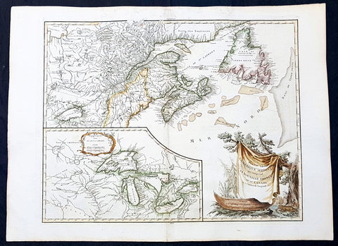
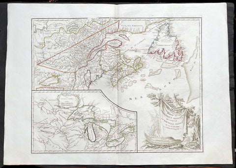
1768 De Vaugondy Large Antique Map Great Lakes of North America & Eastern Canada
- Title : Partie De L Amerique Septent. qui comprend La Nouvelle France ou le Canada...Par le Sr Robert de Vaugondy; Supplement pour Les Lacs du Canada
- Date : 1768
- Condition: (A+) Fine Condition
- Ref: 93128
- Size: 30in x 22in (760mm x 560mm)
Description:
This large original beautifully hand coloured, scarce 2nd edition antique map of The Great Lakes of North America, Eastern Canada & part of New England, with border changes from the 1763 Treaty of Paris, was published in 1768 by Robert Du Vaugondy in his Atlas Universal.
A nice example, beautiful hand colour on age toned heavy paper with original margins with a heavy dark ink denoting an early pressing.
General Definitions:
Paper thickness and quality: - Heavy and stable
Paper color : - off white
Age of map color: - Original & later
Colors used: - Yellow, green, blue, pink
General color appearance: - Authentic
Paper size: - 30in x 22in (760mm x 560mm)
Plate size: - 25in x 19 1/2in (635mm x 495mm)
Margins: - Min 1in (25mm)
Imperfections:
Margins: - Light spotting in top margin
Plate area: - None
Verso: - None
Background:
The mapping of the Great Lakes region began in the early seventeenth century, when the first indications of the lakes appeared on maps made by European cartographers. By the mid-1600s, the maps of French Royal Geographer Nicolas Sanson had recognizable depictions of all five Great Lakes. His map is imprecise—Lake Superior lacks its distinctive shape and is unbounded on the west—but Lakes Ontario, Erie, Huron and Michigan can be discerned without difficulty. The lack of any reference to the Mississippi River in Sansons map reflects how little cartographers really knew about the region at the time.
Until the late eighteenth century, maps were made with information acquired in an irregular and imprecise manner. They were not based on formal surveys, but on written records supplemented with sketches by explorers, missionaries and trappers traveling the Upper Midwest. European cartographers had the task of fitting together this often contradictory information and putting the results into the framework of a geographic map. Instead of being mapped in terms of latitude and longitude, prominent places were usually located in relation to other places, which were, of course, similarly positioned. Distances could not be measured with any accuracy at this time, so these maps were liable to gross errors.
The early maps in the Making Maps, Mapping History exhibit provide a capsulized view of the growth of geographical knowledge of the Great Lakes region. As noted above, Sansons map was the first to display all five of the Great Lakes. Vincenzo Maria Coronelli, the cosmographer of the Republic of Venice, used information supplied by Jesuit missionaries in a 1688 map that was the first accurate depiction of the Great Lakes and the Mississippi River. French cartographer Guillaume De LIsle further refined the image and provided an outline that was not substantially improved until surveyors entered the region in the nineteenth century.
The first official government surveys of the Great Lakes were hydrographic surveys conducted by the British Admiralty under the direction of Capt. Henry W. Bayfield. Bayfield spent his entire career surveying the St. Lawrence River and the Great Lakes, beginning with Lake Superior in 1816. The lake-shore city of Bayfield, Wis., was named in honor of this pioneer surveyor.
One of the first acts of the new government of the United States was to establish a system for the orderly settlement of its western lands. Under the Ordinance of 1785, land surveyors went into the western territories in advance of settlement to divide the land into townships of 36 square- mile sections. Though mapping was not the governments primary aim, the surveys provided ample grist for the mapmakers mill, and the regions were, for the first time, mapped with considerable accuracy. The federal government, however, was not yet in the business of making maps for the public. That was left to enterprising individuals, such as Samuel Morrison, Elisha Dwelle and Joshua Hathaway, who produced one of the first topographical maps of the Wisconsin Territory in 1837.
The surveys of the General Land Office served as the basis for the mapping of much of the Great Lakes region from around 1800, when the surveys began, until about 1890, when the U.S. Geological Survey began to map the region again. In some cases, however, the old surveys were not entirely superseded until the mid-20th century. The distinctive feature of maps based on these surveys is the invariable presence of the township grid.
As population and commerce in the Great Lakes region grew, the federal government assumed responsibility for charting the lakes for navigation. The U.S. Lake Survey began in 1841 with an appropriation of $15,000. Before the Civil War, the work was conducted by officers of the Corps of Topographical Engineers. Its initial survey was completed in 1882, but the need for contin- uous revisions caused it to be reactivated a few years later. The Topographical Engineers merged with the U.S. Army Corps of Engineers in 1863, and the Lake Survey remained in the hands of the Corps of Engineers until 1970, when it became part of the newly formed National Ocean Survey (now known as the National Ocean Service).
The U.S. Lake Survey conducted far more rigorous surveys than those of the General Land Office, which used instruments no more sophisticated than a surveyors compass and a Gunters chain. The Lake Survey used an array of precision instruments and employed triangulation to form the geographic framework of the maps. Triangulation allowed the transfer of geographical coordinates from point to point throughout the system and, for the first time, geographical locations were determined with precision. Inland navigation prompted Congress to order a variety of government surveys. During the era of canal building, surveys like the one for the Portage Canal were common. Most of them were conducted by the Corps of Engineers, as were the surveys of the great rivers, such as the Mississippi.
The degree of accuracy accorded Great Lakes navigators was generally not matched on land for many years to come. The task of precisely mapping the United States by covering it with large-scale topographic quadrangle maps was given to the newly formed U.S. Geological Survey (USGS) in the 1880s. John Wesley Powell, the second director of the USGS, stated that the mapping of the United States could be accomplished in 25 years, but that goal was not accomplished until the 1980s. The first topographic maps of Wisconsin appeared in the 1890s, when much of the southeastern part of the state was surveyed. The surveys were quickly done, however, and most of the sheets needed at least minor revision within the next decade. Despite a rapid start, the topographic mapping of Wisconsin bogged down and ultimately was not completed until 1983. Mapping standards changed entirely with the application of aerial photography around 1930. Following World War II, all Wisconsin topographic sheets were derived from photographs.
Today, polar-orbiting satellites with thematic mappers can, in a single day, record images that reveal Great Lakes water quality and temperature, the streets and large buildings of urban areas, and the general health of forests, wetlands and farmlands, including the identity of such crops as corn, hay and alfalfa. The detailed precision of todays computerized Space Age technology no doubt would have astounded Nicolas Sanson—but the seventeenth-century mapmakers ability to create a fairly accurate map of a world he had only heard and read about is equally astounding to twenty-first-century mapmakers.
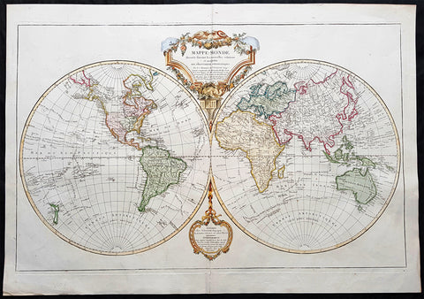
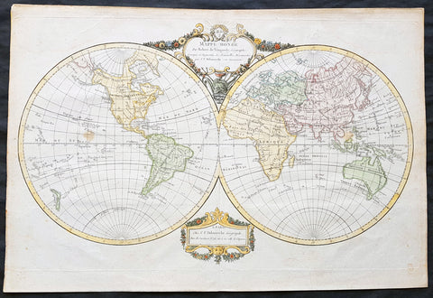
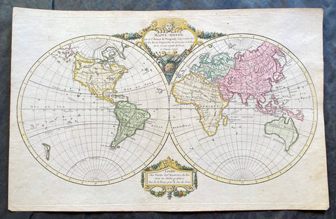
1812 Robert De Vaugondy Large Antique Twin Hempishere World Map - New Holland
- Title : Mappe-Monde Dressee Suivant les Nouvelles Relations et Assujettie aux Observations Astronomiques…, dated 1812
- Size: 31in x 22in (790mm x 560mm)
- Condition: (A+) Fine Condition
- Date : 1812
- Ref #: 50672
Description:
This beautifully hand colured, large original copper-plate engraved antique Twin Hemisphere World Map by Robert Du Vaugondy was engraved in 1812 - dated in the title cartouche - and was published by De Vaugondys successor Charles Francois Delamarche.
General Definitions:
Paper thickness and quality: - Heavy and stable
Paper color : - off white
Age of map color: - Original
Colors used: - Yellow, green, blue, pink
General color appearance: - Authentic
Paper size: - 31in x 22in (790mm x 560mm)
Plate size: - 29 1/2in x 18 3/4in (750mm x 475mm)
Margins: - Min 1in (25mm)
Imperfections:
Margins: - None
Plate area: - None
Verso: - None
Background:
Fifth state of this attractive double hemisphere world first issued in 1749. The map has been updated with information, particularly the additional discoveries of Cook, La Perouse, Vancouver, and Mackensie as noted in the supplementary cartouche.
With these discoveries now reflected in the map, we no longer see the notion of a Northeast Passage, Tasmania is separated from the Australian mainland. However, much of the inland Pacific Northwest is still relatively blank. The tracks of explorations and trade routes are shown in detail throughout. The large title cartouche is draped with a garland of flowers. (Ref: Tooley; M&B)
1783 R. De Vaugondy Large Antique 1st Post Revolutionary Map of North America
- Title : Amerique Septentrionale ...Les Etats Unis...1783...Robert De Vaugondy
- Ref #: 93503-1
- Size: 27 1/2in x 21 1/2in (700mm x 540mm)
- Date : 1783
- Condition: (A+) Fine Condition
Description:
This large original beautifully hand coloured copper plate antique map of post revolutionary North America & the newly form United States was engraved in 1783 - dated - and was published by Robert De Vaugondy in his large elephant folio Atlas Universal
This map is in beautiful original condition, original margins, original outline colour on strong sturdy paper with a heavy impression. A must for any collector of maps of historical importance.
General Definitions:
Paper thickness and quality: - Heavy and stable
Paper color : - off white
Age of map color: - Original
Colors used: - Blue, pink, red, green, yellow
General color appearance: - Authentic
Paper size: - 27 1/2in x 21 1/2in (700mm x 540mm)
Plate size: - 25 1/2in x 18 1/2in (650mm x 465mm)
Margins: - Min 1in (25mm)
Imperfections:
Margins: - None
Plate area: - None
Verso: - None
Background:
This is Robert De Vaugondys 5th State of his North America map and one of the first to show the newly liberated American States, after the American Revolutionary War 1775 - 1783.
The maps includes an engraved borderline for the newly founded United States as agreed upon by the Treaty of Paris in 1783. Also, the maps title was altered from earlier states to incorporate the name (in French) for the United States, Etats Unis, which also appears on the map itself. This state includes much other new information along with the place names that were added to the previous state, such as the Newport, New York City, and Bermuda. Florida is shown as an archipelago and the coastline of California is quite curious, with a continuation of the coastline in the inset map of the Northwest showing some of the mythical cartography, such as the Sea of the West and River of the West, which were debated among map scholars and explorers until Captain James Cook dispelled these myths in his three Voyages to the Pacific.
The map also locates the area identified as Fou-sang, reflecting the belief that Chinese mariners may have reached America, the location of the mythical colony of Fou-sang. According to some historians such as Charles Godfrey Leland and Joseph de Guignes ( Le Fou-Sang des Chinois est-il lAmérique Mémoires de lAcadémie des Inscriptions et Belles Lettres, tome 28, Paris, 1761), the distances given by Hui Shen (20,000 Chinese li) would locate Fou-sang on the west coast of the American continent, near British Columbia.
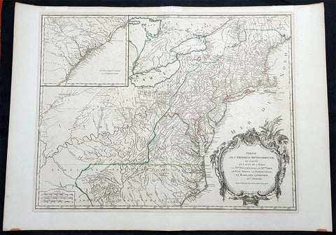
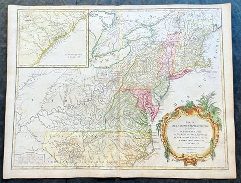
1768 Robert De Vaugondy Large Antique 2nd edition Map of Colonial United States
- Title : Partie De L Amerique Septentrionale, qui Comprend Le Cours De L Ohio...Par le Sr Robert de Vaugondy
- Date : 1768
- Condition: (A+) Fine Condition
- Ref: 93129
- Size: 30in x 22in (760mm x 560mm)
Description:
This large original beautifully hand coloured, scarce 2nd edition antique map of the east coast of the United States, illustrating the course of the Ohio River and stretching from New England to the Carolinas, north to the Great Lakes and south to the Mississippi - with an inset map of The Carolinas - was published in 1768 by Robert Du Vaugondy in his Atlas Universal.
This is one of the best examples of this map I have seen, beautiful hand colour on age toned heavy paper with original margins with a heavy dark ink denoting an early pressing.
General Definitions:
Paper thickness and quality: - Heavy and stable
Paper color : - off white
Age of map color: - Original & later
Colors used: - Yellow, green, blue, pink
General color appearance: - Authentic
Paper size: - 30in x 22in (760mm x 560mm)
Plate size: - 25in x 19 1/2in (635mm x 495mm)
Margins: - Min 1in (25mm)
Imperfections:
Margins: - Light spotting in top margin
Plate area: - None
Verso: - None
Background:
Second state of the early de Vaugondy map of the British colonies, with changes after the 1763 Treaty of Paris, with Virginia & Carolina extended to the Mississippi and Pennsylvania extended to Lake Erie. The majority of geographical information is based upon John Mitchells great map of North America from the mid 1750s, also drawing from Lewis, Evans on the Middle British Colonies and Joshua Frys and Peter Jeffersons map of Virginia and Maryland. The Mitchell map was the culmination of many years of British surveying in the North American Colonies and was considered one of the best maps of the continent available to Europeans and Americans in the mid-eighteenth century.
De Vaugondys rendition does not copy the full scope of Mitchells map but instead focuses on the colonies stretching from southern Maine to the Carolinas. In the top left corner is an inset of South Carolina and Georgia. De Vaugondy also pays special attention to the river systems and settlements. This map shows some of the earliest accurate information of the trans-Allegheny regions (the Ohio River, Kentucky, Tennessee and Parts of Ohio) and inland areas to the southeast of the Great Lakes and interior of New England.
Maine is still part of the Massachusetts Bay Colony. During this era. The dispute between New Hampshire and New York over who controlled the area which is now Vermont has been resolved. The outbreak of the French & Indian War (Seven Years War) briefly suspended interest in the disputed area, and it was not until 1764 that the British crown upheld New Yorks claim to Vermont. Included is a beautiful title cartouche in the Rococo style. (Ref: Tooley; M&B)
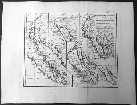
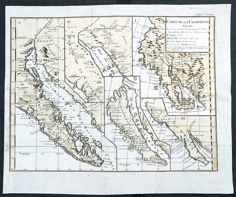
1770 De Vaugondy & Diderot Antique Map of Various Cartographical Views of California
- Title : Carte de la Californie suivant / I. La carte manuscrite de l'Amérique de Mathieu Néron Pecci olen dresse à Florence en 1604 / II. Sanson 1656 / III. De L'Isle Amérique Sept. 1700 / IV. le Pere Kino Jesuite en 1705 / V. La Societe des Jésuites en 1767.
- Ref: 61000
- Size: 20 1/2in x 15 3/4in (520mm x 400mm)
- Date : 1770
- Condition: (A+) Fine Condition
Description:
This fine large historically important map, illustrating 5 of the most influential depictions of California and its cartographical evolution between 1604 and 1767.
The map was engraved by the important French cartographer Robert De Vaugondy, for the 1770 edition of the Denis DiderotEncyclopaedie Raisonee des Sciences des Artes.
The map is in fine B&W original condition with wide margins and a dark impression with clean sturdy cabled laid paper.
The earliest map (upper right corner) is based upon a manuscript map by Mathieu Neron Pecci, drawn in Florence in 1604. This map also forms the basis of a map popularized in 1770 by Rigobert Bonne.
The second map is Nicholas Sanson's map of California as an Island, based upon his larger map of 1656. This map was probably the single most influential projection of California as an Island.
The third map map (lower right) is a portion of Guillaume De L'Isles map of America, published in 1700. While not truly peninsular in nature, it was influential in the shift back toward depicting California as a Peninsula.
The fourth map (upper center) is a portion of Fra. Eusebio Kino's map, generally credited with being the map which dispelled the California as and Island myth. Issued in 1705, the map is based upon Father Kino's overland expedition from the mainland to the top of the Gulf of Cortez.
The fifth map is one of the most interesting and enduring maps of California and the Baja (left side). Initially issued by the Society of Jesuits in 1767, it was popularized by Isaak Tirion and was perhaps the most interesting of all maps of Baja California in the 2nd half of the 18th Century.
This map was 1 of 10 maps to appear in the Supplement to Diderot's monumental encyclopedia, one of the most influential and widely distirbuted works of the second half of the 18th Century. Diderot's goal was to examine and display the popular geographical conceptions of several different parts of the world where the knowledge of the region's geogaphy was still largely unknown and evolving. Other maps treat the Northwest Passage, Northeast Passage and the NW Coast of America, among other topics.
A marvelous amalgam and an essential map for collectors of North American & California maps.
Encyclopaedie Raisonee des Sciences des Artes: At the time of publication these maps of Encyclopedie were some of the most in-depth and accurate maps published of Asia, Canada, California and the NW region of America.
Diderot's maps were intended to further an understanding of the Western Coast of America, and NE Asia, during a time period immediately prior to Cook's voyage to the region - less than a decade later- where numerous theories abounded on the NW Coast of America.(Ref: Tooley; M&B)
General Description:
Paper thickness and quality: - Heavy and stable
Paper color: - off white
Age of map color: -
Colors used: -
General color appearance: -
Paper size: - 20 1/2in x 15 3/4in (520mm x 400mm)
Plate size: - 15 1/2in x 12 1/2in (390mm x 320mm)
Margins: - Min 2in (50mm)
Imperfections:
Margins: - None
Plate area: - Folds as issued
Verso: - None
1768 Robert De Vaugondy Large Antique 2nd edition Map of Colonial United States
- Title : Partie De L Amerique Septentrionale, qui Comprend Le Cours De L Ohio...Par le Sr Robert de Vaugondy
- Date : 1768
- Condition: (A+) Fine Condition
- Ref: 93504
- Size: 30in x 21in (760mm x 550mm)
Description:
This large original beautifully hand coloured, scarce 2nd edition antique map of the east coast of the United States, illustrating the course of the Ohio River and stretching from New England to the Carolinas, north to the Great Lakes and south to the Mississippi - with an inset map of The Carolinas - was published in 1768 by Robert Du Vaugondy in his Atlas Universal.
This is one of the best examples of this map I have seen, beautiful hand colour on age toned heavy paper with original margins with a heavy dark ink denoting an early pressing.
General Definitions:
Paper thickness and quality: - Heavy and stable
Paper color : - off white
Age of map color: - Original & later
Colors used: - Yellow, green, blue, pink
General color appearance: - Authentic
Paper size: - 30in x 22in (760mm x 560mm)
Plate size: - 25in x 19 1/2in (635mm x 495mm)
Margins: - Min 1in (25mm)
Imperfections:
Margins: - None
Plate area: - None
Verso: - None
Background:
Second state of the early de Vaugondy map of the British colonies, with changes after the 1763 Treaty of Paris, with Virginia & Carolina extended to the Mississippi and Pennsylvania extended to Lake Erie. The majority of geographical information is based upon John Mitchells great map of North America from the mid 1750s, also drawing from Lewis, Evans on the Middle British Colonies and Joshua Frys and Peter Jeffersons map of Virginia and Maryland. The Mitchell map was the culmination of many years of British surveying in the North American Colonies and was considered one of the best maps of the continent available to Europeans and Americans in the mid-eighteenth century.
De Vaugondys rendition does not copy the full scope of Mitchells map but instead focuses on the colonies stretching from southern Maine to the Carolinas. In the top left corner is an inset of South Carolina and Georgia. De Vaugondy also pays special attention to the river systems and settlements. This map shows some of the earliest accurate information of the trans-Allegheny regions (the Ohio River, Kentucky, Tennessee and Parts of Ohio) and inland areas to the southeast of the Great Lakes and interior of New England.
Maine is still part of the Massachusetts Bay Colony. During this era. The dispute between New Hampshire and New York over who controlled the area which is now Vermont has been resolved. The outbreak of the French & Indian War (Seven Years War) briefly suspended interest in the disputed area, and it was not until 1764 that the British crown upheld New Yorks claim to Vermont. Included is a beautiful title cartouche in the Rococo style. (Ref: Tooley; M&B)
1768 Robert De Vaugondy Large Antique 2nd edition Map of Colonial United States
- Title : Partie De L Amerique Septentrionale, qui Comprend Le Cours De L Ohio...Par le Sr Robert de Vaugondy
- Date : 1755 (1768)
- Condition: (A) Very Good Condition
- Ref: 17057
- Size: 26in x 20 1/2in (660mm x 520mm)
Description:
This large original beautifully hand coloured, scarce 2nd edition antique map of the east coast of the United States, illustrating the course of the Ohio River and stretching from New England to the Carolinas, north to the Great Lakes and south to the Mississippi - with an inset map of The Carolinas - was published in 1768 - dated 1755 in the cartouche - by Robert Du Vaugondy in his Atlas Universal.
This map is all original with hand colour on age toned heavy paper with original margins with a heavy dark ink denoting an early pressing.
General Definitions:
Paper thickness and quality: - Heavy and stable
Paper color : - off white
Age of map color: - Original & later
Colors used: - Yellow, green, blue, pink
General color appearance: - Authentic
Paper size: - 26in x 20 1/2in (660mm x 520mm)
Plate size: - 25in x 19 1/2in (635mm x 495mm)
Margins: - Min 1/2in (12mm)
Imperfections:
Margins: - Age toning and spotting
Plate area: - Age toning and spotting
Verso: - Age toning and spotting
Background:
Second state of the early de Vaugondy map of the British colonies, with changes after the 1763 Treaty of Paris, with Virginia & Carolina extended to the Mississippi and Pennsylvania extended to Lake Erie. The majority of geographical information is based upon John Mitchells great map of North America from the mid 1750s, also drawing from Lewis, Evans on the Middle British Colonies and Joshua Frys and Peter Jeffersons map of Virginia and Maryland. The Mitchell map was the culmination of many years of British surveying in the North American Colonies and was considered one of the best maps of the continent available to Europeans and Americans in the mid-eighteenth century.
De Vaugondys rendition does not copy the full scope of Mitchells map but instead focuses on the colonies stretching from southern Maine to the Carolinas. In the top left corner is an inset of South Carolina and Georgia. De Vaugondy also pays special attention to the river systems and settlements. This map shows some of the earliest accurate information of the trans-Allegheny regions (the Ohio River, Kentucky, Tennessee and Parts of Ohio) and inland areas to the southeast of the Great Lakes and interior of New England.
Maine is still part of the Massachusetts Bay Colony. During this era. The dispute between New Hampshire and New York over who controlled the area which is now Vermont has been resolved. The outbreak of the French & Indian War (Seven Years War) briefly suspended interest in the disputed area, and it was not until 1764 that the British crown upheld New Yorks claim to Vermont. Included is a beautiful title cartouche in the Rococo style. (Ref: Tooley; M&B)
1755 (1768) Robert De Vaugondy Large Antique 2nd edition Map of Colonial United States
- Title : Partie De L Amerique Septentrionale, qui Comprend Le Cours De L Ohio...Par le Sr Robert de Vaugondy
- Date : 1755 (1768)
- Condition: (A+) Fine Condition
- Ref: 93514
- Size: 26in x 20 1/2in (660mm x 520mm)
Description:
This large original beautifully hand coloured, scarce 2nd edition antique map of the east coast of the United States, illustrating the course of the Ohio River and stretching from New England to the Carolinas, north to the Great Lakes and south to the Mississippi - with an inset map of The Carolinas - was published in 1768 - dated 1755 in the cartouche - by Robert Du Vaugondy in his Atlas Universal.
This map is all original with hand colour on age toned heavy paper with original margins with a heavy dark ink denoting an early pressing.
General Definitions:
Paper thickness and quality: - Heavy and stable
Paper color : - off white
Age of map color: - Original & later
Colors used: - Yellow, green, blue, pink
General color appearance: - Authentic
Paper size: - 26in x 20 1/2in (660mm x 520mm)
Plate size: - 25in x 19 1/2in (635mm x 495mm)
Margins: - Min 1/2in (12mm)
Imperfections:
Margins: - Light age toning in margins
Plate area: - None
Verso: - None
Background:
Second state of the early de Vaugondy map of the British colonies, with changes after the 1763 Treaty of Paris, with Virginia & Carolina extended to the Mississippi and Pennsylvania extended to Lake Erie. The majority of geographical information is based upon John Mitchells great map of North America from the mid 1750s, also drawing from Lewis, Evans on the Middle British Colonies and Joshua Frys and Peter Jeffersons map of Virginia and Maryland. The Mitchell map was the culmination of many years of British surveying in the North American Colonies and was considered one of the best maps of the continent available to Europeans and Americans in the mid-eighteenth century.
De Vaugondys rendition does not copy the full scope of Mitchells map but instead focuses on the colonies stretching from southern Maine to the Carolinas. In the top left corner is an inset of South Carolina and Georgia. De Vaugondy also pays special attention to the river systems and settlements. This map shows some of the earliest accurate information of the trans-Allegheny regions (the Ohio River, Kentucky, Tennessee and Parts of Ohio) and inland areas to the southeast of the Great Lakes and interior of New England.
Maine is still part of the Massachusetts Bay Colony. During this era. The dispute between New Hampshire and New York over who controlled the area which is now Vermont has been resolved. The outbreak of the French & Indian War (Seven Years War) briefly suspended interest in the disputed area, and it was not until 1764 that the British crown upheld New Yorks claim to Vermont. Included is a beautiful title cartouche in the Rococo style. (Ref: Tooley; M&B)
1755 (1778) De Vaugondy Large Antique Map of The Great Lakes America East Canada
- Title : Partie De L Amerique Septent. qui comprend La Nouvelle France ou le Canada...Par le Sr Robert de Vaugondy; Supplement pour Les Lacs du Canada
- Ref #: 17017
-
Condition: (A+) Fine Condition
- Size: 31 1/2in x 22 1/2in (800m x 570mm)
- Date : 1775 (1778)
Description:
This large original beautifully hand coloured, scarce 4th edition, antique map of The Great Lakes of North America, Eastern Canada & part of New England, with border changes from the 1763 Treaty of Paris, was published in 1768 by Robert Du Vaugondy in his Atlas Universal.
One of the nicest examples I have seen, of this scarce and beautiful hand coloured map, on heavy paper with original margins and heavy dark ink denoting an early pressing.
General Definitions:
Paper thickness and quality: - Heavy and stable
Paper color : - off white
Age of map color: - Original
Colors used: - Red, yellow, green, blue
General color appearance: - Authentic
Paper size: - 31 1/2in x 22 1/2in (800m x 570mm)
Plate size: - 24in x 19 1/2in (610mm x 495mm)
Margins: - Min 2in (50mm)
Imperfections:
Margins: - None
Plate area: - None
Verso: - None
Background:
The mapping of the Great Lakes region began in the early seventeenth century, when the first indications of the lakes appeared on maps made by European cartographers. By the mid-1600s, the maps of French Royal Geographer Nicolas Sanson had recognizable depictions of all five Great Lakes. His map is imprecise—Lake Superior lacks its distinctive shape and is unbounded on the west—but Lakes Ontario, Erie, Huron and Michigan can be discerned without difficulty. The lack of any reference to the Mississippi River in Sansons map reflects how little cartographers really knew about the region at the time.
Until the late eighteenth century, maps were made with information acquired in an irregular and imprecise manner. They were not based on formal surveys, but on written records supplemented with sketches by explorers, missionaries and trappers traveling the Upper Midwest. European cartographers had the task of fitting together this often contradictory information and putting the results into the framework of a geographic map. Instead of being mapped in terms of latitude and longitude, prominent places were usually located in relation to other places, which were, of course, similarly positioned. Distances could not be measured with any accuracy at this time, so these maps were liable to gross errors.
The early maps in the Making Maps, Mapping History exhibit provide a capsulized view of the growth of geographical knowledge of the Great Lakes region. As noted above, Sansons map was the first to display all five of the Great Lakes. Vincenzo Maria Coronelli, the cosmographer of the Republic of Venice, used information supplied by Jesuit missionaries in a 1688 map that was the first accurate depiction of the Great Lakes and the Mississippi River. French cartographer Guillaume De LIsle further refined the image and provided an outline that was not substantially improved until surveyors entered the region in the nineteenth century.
The first official government surveys of the Great Lakes were hydrographic surveys conducted by the British Admiralty under the direction of Capt. Henry W. Bayfield. Bayfield spent his entire career surveying the St. Lawrence River and the Great Lakes, beginning with Lake Superior in 1816. The lake-shore city of Bayfield, Wis., was named in honor of this pioneer surveyor.
One of the first acts of the new government of the United States was to establish a system for the orderly settlement of its western lands. Under the Ordinance of 1785, land surveyors went into the western territories in advance of settlement to divide the land into townships of 36 square- mile sections. Though mapping was not the governments primary aim, the surveys provided ample grist for the mapmakers mill, and the regions were, for the first time, mapped with considerable accuracy. The federal government, however, was not yet in the business of making maps for the public. That was left to enterprising individuals, such as Samuel Morrison, Elisha Dwelle and Joshua Hathaway, who produced one of the first topographical maps of the Wisconsin Territory in 1837.
The surveys of the General Land Office served as the basis for the mapping of much of the Great Lakes region from around 1800, when the surveys began, until about 1890, when the U.S. Geological Survey began to map the region again. In some cases, however, the old surveys were not entirely superseded until the mid-20th century. The distinctive feature of maps based on these surveys is the invariable presence of the township grid.
As population and commerce in the Great Lakes region grew, the federal government assumed responsibility for charting the lakes for navigation. The U.S. Lake Survey began in 1841 with an appropriation of $15,000. Before the Civil War, the work was conducted by officers of the Corps of Topographical Engineers. Its initial survey was completed in 1882, but the need for contin- uous revisions caused it to be reactivated a few years later. The Topographical Engineers merged with the U.S. Army Corps of Engineers in 1863, and the Lake Survey remained in the hands of the Corps of Engineers until 1970, when it became part of the newly formed National Ocean Survey (now known as the National Ocean Service).
The U.S. Lake Survey conducted far more rigorous surveys than those of the General Land Office, which used instruments no more sophisticated than a surveyors compass and a Gunters chain. The Lake Survey used an array of precision instruments and employed triangulation to form the geographic framework of the maps. Triangulation allowed the transfer of geographical coordinates from point to point throughout the system and, for the first time, geographical locations were determined with precision. Inland navigation prompted Congress to order a variety of government surveys. During the era of canal building, surveys like the one for the Portage Canal were common. Most of them were conducted by the Corps of Engineers, as were the surveys of the great rivers, such as the Mississippi.
The degree of accuracy accorded Great Lakes navigators was generally not matched on land for many years to come. The task of precisely mapping the United States by covering it with large-scale topographic quadrangle maps was given to the newly formed U.S. Geological Survey (USGS) in the 1880s. John Wesley Powell, the second director of the USGS, stated that the mapping of the United States could be accomplished in 25 years, but that goal was not accomplished until the 1980s. The first topographic maps of Wisconsin appeared in the 1890s, when much of the southeastern part of the state was surveyed. The surveys were quickly done, however, and most of the sheets needed at least minor revision within the next decade. Despite a rapid start, the topographic mapping of Wisconsin bogged down and ultimately was not completed until 1983. Mapping standards changed entirely with the application of aerial photography around 1930. Following World War II, all Wisconsin topographic sheets were derived from photographs.
Today, polar-orbiting satellites with thematic mappers can, in a single day, record images that reveal Great Lakes water quality and temperature, the streets and large buildings of urban areas, and the general health of forests, wetlands and farmlands, including the identity of such crops as corn, hay and alfalfa. The detailed precision of todays computerized Space Age technology no doubt would have astounded Nicolas Sanson—but the seventeenth-century mapmakers ability to create a fairly accurate map of a world he had only heard and read about is equally astounding to twenty-first-century mapmakers.
Please note all items auctioned are genuine, we do not sell reproductions. A Certificate of Authenticity (COA) can be issued on request.
1799 Robert De Vaugondy & Charles Delamarche Antique Twin Hemiphere World Map
- Title : Mappe-Monde par Robert de Vaugondy Geographe Corrigee par Delamarche son Successeur
- Size: 18in x 12 1/2in (460mm x 310mm)
- Condition: (A+) Fine Condition
- Date : 1799
- Ref #: 50687
Description:
This beautifully hand coloured original copper-plate engraved antique Twin Hemisphere World Map by Robert De Vaugondy was published by Charles Francois Delamarche, De Vaugondy\'s successor, in 1799.
General Definitions:
Paper thickness and quality: - Heavy and stable
Paper color : - off white
Age of map color: - Original
Colors used: - Yellow, green, blue, pink
General color appearance: - Authentic
Paper size: - 18in x 12 1/2in (460mm x 310mm)
Plate size: - 17 1/2in x 10 3/4in (445mm x 275mm)
Margins: - Min 1/2in (12mm)
Imperfections:
Margins: - Light age toning in margins
Plate area: - 2 light spots in Pacific & SE Asia
Verso: - None
Background:
Fine twin hemisphere world map illustrating the known world at the end of the 18th century. Although almost complete there are a few regions of uncertainty. The route taken by Cook on his final voyage is included which reaches from Australia, New Zealand to Hawaii and the very northern reaches of western North America which were surveyed and mapped by Cook extensively. The recent discovery of Bass Strait separating Tasmania from the mainland of Australia is named and although there is some indication of a northern Arctic region there is no mention of the great southern Antarctica regions. A great map showing the world at the beginning of modern transformation. (Ref: Tooley; M&B)
1770 De Vaugondy & Diderot Antique Maps of Cartographical Views of California
- Title : Carte de la Californie suivant / I. La carte manuscrite de l'Amérique de Mathieu Néron Pecci olen dresse à Florence en 1604 / II. Sanson 1656 / III. De L'Isle Amérique Sept. 1700 / IV. le Pere Kino Jesuite en 1705 / V. La Societe des Jésuites en 1767.
- Ref: 93434
- Size: 17in x 14in (430mm x 355mm)
- Date : 1770
- Condition: (A) Very Good Condition
Description:
This fine large historically important original hand coloured, copper-plate engraved antique map, illustrating 5 of the most influential depictions of California and its cartographical evolution between 1604 and 1767.
The map was engraved by the important French cartographer Robert De Vaugondy, for the 1770 edition of the Denis Diderot Encyclopaedie Raisonee des Sciences des Artes.
- The earliest map (upper right corner) is based upon a manuscript map by Mathieu Neron Pecci, drawn in Florence in 1604. This map also forms the basis of a map popularized in 1770 by Rigobert Bonne.
- The second map is Nicholas Sanson's map of California as an Island, based upon his larger map of 1656. This map was probably the single most influential projection of California as an Island.
- The third map map (lower right) is a portion of Guillaume De L'Isles map of America, published in 1700. While not truly peninsular in nature, it was influential in the shift back toward depicting California as a Peninsula.
- The fourth map (upper center) is a portion of Fra. Eusebio Kino's map, generally credited with being the map which dispelled the California as and Island myth. Issued in 1705, the map is based upon Father Kino's overland expedition from the mainland to the top of the Gulf of Cortez.
- The fifth map is one of the most interesting and enduring maps of California and the Baja (left side). Initially issued by the Society of Jesuits in 1767, it was popularized by Isaak Tirion and was perhaps the most interesting of all maps of Baja California in the 2nd half of the 18th Century.
General Definitions:
Paper thickness and quality: - Heavy and stable
Paper color : - off white
Age of map color: - Early
Colors used: - Yellow, pink
General color appearance: - Authentic
Paper size: - 17in x 14in (430mm x 355mm)
Plate size: - 16in x 12in (405mm x 315mm)
Margins: - Min 1/2in (12mm)
Imperfections:
Margins: - Bottom left margin expended from plate mark
Plate area: - Folds as issued
Verso: - None
Background:
This map was 1 of 10 maps to appear in the Supplement to Diderot\'s monumental encyclopedia, one of the most influential and widely distirbuted works of the second half of the 18th Century. Diderot\'s goal was to examine and display the popular geographical conceptions of several different parts of the world where the knowledge of the region\'s geogaphy was still largely unknown and evolving. Other maps treat the Northwest Passage, Northeast Passage and the NW Coast of America, among other topics.
A marvelous amalgam and an essential map for collectors of North American & California maps.
Encyclopaedie Raisonee des Sciences des Artes: At the time of publication these maps of Encyclopedie were some of the most in-depth and accurate maps published of Asia, Canada, California and the NW region of America.
Diderot\'s maps were intended to further an understanding of the Western Coast of America, and NE Asia, during a time period immediately prior to Cook\'s voyage to the region - less than a decade later- where numerous theories abounded on the NW Coast of America.(Ref: Tooley; M&B)
1780 Robert De Vaugondy Antique Twin Hemisphere World Map
- Title : Mappe-Monde par Robert de Vaugondy Geographe ord du Roi
- Size: 17 1/2in x 11 1/2in (440mm x 290mm)
- Condition: (A+) Fine Condition
- Date : 1780
- Ref #: 17060
Description:
This beautifully hand coloured original copper-plate engraved antique Twin Hemisphere World Map by Robert De Vaugondy was engraved in 1780 - dated in title and published in the same year.
General Definitions:
Paper thickness and quality: - Heavy and stable
Paper color : - off white
Age of map color: - Original
Colors used: - Yellow, green, blue, pink
General color appearance: - Authentic
Paper size: - 17 1/2in x 11 1/2in (440mm x 290mm)
Plate size: - 17 1/2in x 11 1/2in (440mm x 290mm)
Margins: - Min 1/2in (12mm)
Imperfections:
Margins: - None
Plate area: - None
Verso: - None
Background:
Fine twin hemisphere world map illustrating the known world in the 18th century. Although almost complete there are a few regions of uncertainty. The route taken by Cook on his final voyage is included which reaches from Australia, New Zealand to Hawaii and the very northern reaches of western North America which were surveyed and mapped by Cook extensively. There is some indication of a northern Arctic region there is no mention of the great southern Antarctica regions. A great map showing the world at the beginning of modern era. (Ref: Tooley; M&B)
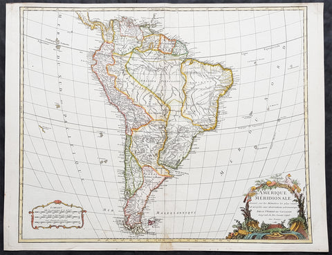
1783 Robert De Vaugondy Large Antique Map of South America - Beautiful
- Title : Amerique Meridionale....Par Le Sr. Robert de Vaugondy...1783
- Size: 25 1/2in x 20in (645mm x 510mm)
- Condition: (A+) Fine Condition
- Date : 1783
- Ref #: 70045
Description:
This magnificent hand coloured original copper-plate engraved antique map of South America by Robert De Vaugondy in 1783 - the date is engraved in the cartouche - was published in De Vaugondys famous The Atlas Universel
General Definitions:
Paper thickness and quality: - Heavy and stable
Paper color : - off white
Age of map color: - Original & later
Colors used: - Blue, pink, red, green, yellow
General color appearance: - Authentic
Paper size: - 25 1/2in x 20in (645mm x 510mm)
Plate size: - 24in x 19 1/2in (610mm x 495mm)
Margins: - Min 1/2in (12mm)
Imperfections:
Margins: - None
Plate area: - None
Verso: - None
Background:
In 1494, Portugal and Spain, the two great maritime European powers of that time, on the expectation of new lands being discovered in the west, signed the Treaty of Tordesillas, by which they agreed, with the support of the Pope, that all the land outside Europe should be an exclusive duopoly between the two countries.
The treaty established an imaginary line along a north-south meridian 370 leagues west of the Cape Verde Islands, roughly 46° 37\' W. In terms of the treaty, all land to the west of the line (known to comprise most of the South American soil) would belong to Spain, and all land to the east, to Portugal. As accurate measurements of longitude were impossible at that time, the line was not strictly enforced, resulting in a Portuguese expansion of Brazil across the meridian.
Beginning in the 1530s, the people and natural resources of South America were repeatedly exploited by foreign conquistadors, first from Spain and later from Portugal. These competing colonial nations claimed the land and resources as their own and divided it in colonies.
European infectious diseases (smallpox, influenza, measles, and typhus) – to which the native populations had no immune resistance – caused large-scale depopulation of the native population under Spanish control. Systems of forced labor, such as the haciendas and mining industry\'s mita also contributed to the depopulation. After this, African slaves, who had developed immunities to these diseases, were quickly brought in to replace them.
The Spaniards were committed to converting their native subjects to Christianity and were quick to purge any native cultural practices that hindered this end; however, many initial attempts at this were only partially successful, as native groups simply blended Catholicism with their established beliefs and practices. Furthermore, the Spaniards brought their language to the degree they did with their religion, although the Roman Catholic Churchs evangelization in Quechua, Aymara, and Guaraní actually contributed to the continuous use of these native languages albeit only in the oral form.
Eventually, the natives and the Spaniards interbred, forming a mestizo class. At the beginning, many mestizos of the Andean region were offspring of Amerindian mothers and Spanish fathers. After independence, most mestizos had native fathers and European or mestizo mothers.
Many native artworks were considered pagan idols and destroyed by Spanish explorers; this included many gold and silver sculptures and other artifacts found in South America, which were melted down before their transport to Spain or Portugal. Spaniards and Portuguese brought the western European architectural style to the continent, and helped to improve infrastructures like bridges, roads, and the sewer system of the cities they discovered or conquered. They also significantly increased economic and trade relations, not just between the old and new world but between the different South American regions and peoples. Finally, with the expansion of the Portuguese and Spanish languages, many cultures that were previously separated became united through that of Latin American.
Guyana was first a Dutch, and then a British colony, though there was a brief period during the Napoleonic Wars when it was colonized by the French. The country was once partitioned into three parts, each being controlled by one of the colonial powers until the country was finally taken over fully by the British.
The European Peninsular War (1807–1814), a theater of the Napoleonic Wars, changed the political situation of both the Spanish and Portuguese colonies. First, Napoleon invaded Portugal, but the House of Braganza avoided capture by escaping to Brazil. Napoleon also captured King Ferdinand VII of Spain, and appointed his own brother instead. This appointment provoked severe popular resistance, which created Juntas to rule in the name of the captured king.
Many cities in the Spanish colonies, however, considered themselves equally authorized to appoint local Juntas like those of Spain. This began the Spanish American wars of independence between the patriots, who promoted such autonomy, and the royalists, who supported Spanish authority over the Americas. The Juntas, in both Spain and the Americas, promoted the ideas of the Enlightenment. Five years after the beginning of the war, Ferdinand VII returned to the throne and began the Absolutist Restoration as the royalists got the upper hand in the conflict.
The independence of South America was secured by Simón Bolívar (Venezuela) and José de San Martín (Argentina), the two most important Libertadores. Bolívar led a great uprising in the north, then led his army southward towards Lima, the capital of the Viceroyalty of Peru. Meanwhile, San Martín led an army across the Andes Mountains, along with Chilean expatriates, and liberated Chile. He organized a fleet to reach Peru by sea, and sought the military support of various rebels from the Vice-royalty of Peru. The two armies finally met in Guayaquil, Ecuador, where they cornered the Royal Army of the Spanish Crown and forced its surrender.
In the Portuguese Kingdom of Brazil, Dom Pedro I (also Pedro IV of Portugal), son of the Portuguese King Dom João VI, proclaimed the independent Kingdom of Brazil in 1822, which later became the Empire of Brazil. Despite the Portuguese loyalties of garrisons in Bahia, Cisplatina and Pará, independence was diplomatically accepted by the crown in Portugal in 1825, on condition of a high compensation paid by Brazil mediatized by the United Kingdom. (Ref: Tooley; M&B)
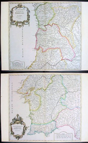
1757 De Vaugondy Large Antique Maps x 2 of North & South Portugal
- Title : Partie Septentrionale Portugal; Partie Meriondalie Portugal
- Ref #: 41589/41590
- Size: 25in x 19in (635mm x 483mm) Each
- Date : 1757
- Condition: (A+) Fine Condition
Description:
These large beautifully hand coloured original antique maps x 2 of Portugal was published by Robert De Vaugondy in Atlas Universal, Paris 1757. (Ref: Tooley; M&B)
General Description:
Paper thickness and quality: - Heavy and stable
Paper color: - off white
Age of map color: - Early
Colors used: - Pink, yellow, green
General color appearance: - Authentic
Paper size: - 25in x 19in (635mm x 483mm) Each
Plate size: - 24in x 19 1/2in (610mm x 495mm) Each
Margins: - Min 1/4in (6mm)
Imperfections:
Margins: - None
Plate area: - None
Verso: - None
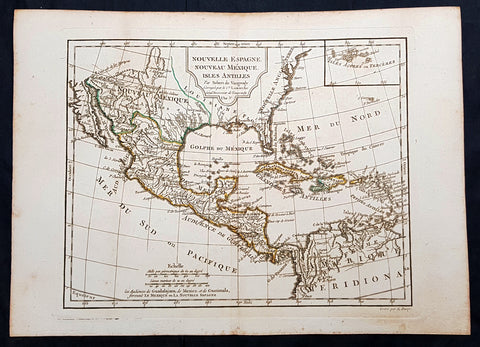
1795 Didier De Vaugondy Antique Map of Texas, Mexico, California, United States
- Title : Nouvelle Espagne Nouveau Mexique Isles Antilles Par Robert De Vaugondy ..L A 3 e
- Ref #: 93503
- Size: 16 1/2in x 11 1/2in (405mm x 295mm)
- Date : 1795
- Condition: (A+) Fine Condition
Description:
This original copper plate engraved map of North and Central America, with the Caribbean, by Didier De Vaugondy was published in the 1795 (L an 3e Post Revolution Year) edition of Nouvel Atlas Portatif
General Definitions:
Paper thickness and quality: - Heavy and stable
Paper color : - off white
Age of map color: - Original
Colors used: - Yellow, green, blue, pink
General color appearance: - Authentic
Paper size: - 16 1/2in x 11 1/2in (405mm x 295mm)
Plate size: - 12 1/2in x 10in (320mm x 255mm)
Margins: - Min 1in (25mm)
Imperfections:
Margins: - Light soiling
Plate area: - None
Verso: - None
Background:
The French Republican calendar also commonly called the French Revolutionary calendar (calendrier révolutionnaire français), was a calendar created and implemented during the French Revolution, and used by the French government for about 12 years from late 1793 to 1805, and for 18 days by the Paris Commune in 1871.
De Vaugondy, Didier Robert 1723 - 1786
Didier Robert de Vaugondy was the son of prominent geographer Gilles Robert de Vaugondy and Didier carried on his fathers impressive work. Together, they published their best-known work, the Atlas Universel (1757). The atlas took fifteen years to create and was released in a folio and ¾ folio edition; both are rare and highly sought-after today. Together and individually, father and son were known for their exactitude and depth of research.
Like his father, Didier served as geographer to King Louis XV. He was especially recognized for his skills in globe making; for example, a pair of his globes made for the Marquise de Pompadour are today in the collection of the Municipal Museum of Chartres. Didier was also the geographer to the Duke of Lorraine. In 1773, he was appointed royal censor in charge of monitoring the information published in geography texts, navigational tracts, and travel accounts.
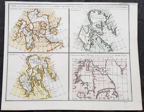
1773 Robert De Vaugondy & Denis Diderot Antique Maps x 4 of Hudson Bay, Canada
- Title : Carte qui represente les differentes connoissances que l on a eues des Terres Arctiques...Robert De Vaugondy...1773
- Size: 16 1/2in x 13in (420mm x 330mm)
- Condition: (A+) Fine Condition
- Date : 1773
- Ref #: 60048
Description:
This magnificent original hand coloured copper-plate engraved antique maps of 4 different time based views of Hudsons Bay & Eastern Canada by Robert De Vaugondy was engraved in 1773 - the date is engraved in the title - and published in the 1775 edition of Denis Diderots (1713-84) Encyclopédie, ou dictionnaire raisonné des sciences, des arts et des métiers (Encyclopedia, or a Systematic Dictionary of the Sciences, Arts, and Crafts).
The four historical views of Hudsons Bay, Canada are 2 x maps by Claude Delisle in 1700 & 1703, one map by Nicolas Sanson in 1750 and the fourth map by Henry Ellis in 1747.
Denis Diderot 1713 – 1784 was a French philosopher, art critic, and writer, best known for serving as co-founder, chief editor, and contributor to the Encyclopédie along with Jean le Rond d Alembert. He was a prominent figure during the Enlightenment.
Diderot began his education by obtaining a Master of Arts degree in philosophy at a Jesuit college in 1732. He considered working in the church clergy before briefly studying law. When he decided to become a writer in 1734, his father disowned him for not entering one of the learned professions. He lived a bohemian existence for the next decade. He befriended philosopher Jean-Jacques Rousseau in 1742.
Though his work was broad as well as rigorous, it did not bring Diderot riches. He secured none of the posts that were occasionally given to needy men of letters; he could not even obtain the bare official recognition of merit that was implied by being chosen a member of the Académie française. He saw no alternative to selling his library to provide a dowry for his daughter. Empress Catherine II of Russia heard of his financial troubles and commissioned an agent in Paris to buy the library. She then requested that the philosopher retain the books in Paris until she required them, and act as her librarian with a yearly salary. Between October 1773 and March 1774, the sick Diderot spent a few months at the empress\'s court in Saint Petersburg.
Diderot died of pulmonary thrombosis in Paris on 31 July 1784, and was buried in the city\'s Église Saint-Roch. His heirs sent his vast library to Catherine II, who had it deposited at the National Library of Russia. He has several times been denied burial in the Panthéon with other French notables. The French government considered memorializing him in this fashion on the 300th anniversary of his birth, but this did not come to pass.
Diderot\'s literary reputation during his lifetime rested primarily on his plays and his contributions to the Encyclopédie; many of his most important works, including Jacques the Fatalist, Rameaus Nephew, Paradox of the Actor, and D Alembert\'s Dream, were published only after his death.
General Definitions:
Paper thickness and quality: - Heavy and stable
Paper color : - off white
Age of map color: - Original
Colors used: - Yellow, green, blue, pink
General color appearance: - Authentic
Paper size: - 16 1/2in x 13in (420mm x 330mm)
Plate size: - 16in x 12 1/2in (405mm x 315mm)
Margins: - Min 1/2in (10mm)
Imperfections:
Margins: - None
Plate area: - None
Verso: - None
Background:
Hudson Bay (sometimes called Hudsons Bay, usually historically) is a large body of saltwater in northeastern Canada.
The Eastern Cree name for Hudson and James Bay is Wînipekw (Southern dialect) or Wînipâkw (Northern dialect), meaning muddy or brackish water. Lake Winnipeg is similarly named by the local Cree, as is the location for the city of Winnipeg.
English explorers and colonists named Hudson Bay after Sir Henry Hudson who explored the bay beginning August 2, 1610 on his ship Discovery. 170 On his fourth voyage to North America, Hudson worked his way around Greenlands west coast and into the bay, mapping much of its eastern coast. Discovery became trapped in the ice over the winter, and the crew survived onshore at the southern tip of James Bay. When the ice cleared in the spring, Hudson wanted to explore the rest of the area, but the crew mutinied on June 22, 1611. They left Hudson and others adrift in a small boat. No one knows the fate of Hudson or the crew members stranded with him, but historians see no evidence that they survived for long afterwards.
In 1668, Nonsuch reached the bay and traded for beaver pelts, leading to the creation of the Hudson\'s Bay Company (HBC) which still bears the historic name. The HBC negotiated a trading monopoly from the English crown for the Hudson Bay watershed, called Rupert\'s Land. France contested this grant by sending several military expeditions to the region, but abandoned its claim in the Treaty of Utrecht (April 1713).
During this period, the Hudsons Bay Company built several factories (forts and trading posts) along the coast at the mouth of the major rivers (such as Fort Severn, Ontario; York Factory and Churchill, Manitoba). The strategic locations were bases for inland exploration. More importantly, they were trading posts with the indigenous peoples who came to them with furs from their trapping season. The HBC shipped the furs to Europe and continued to use some of these posts well into the 20th century. (Ref: Tooley; M&B)

1772 De Vaugondy Visscher Large Antique Map of California & SW America
- Title : Carte De La Californie Et Des Pays Nord Ouest separes de L'Asie par le Detroit d'Anian…1772
- Date : 1772
- Ref # : 50674
- Size : 20in x 15 3/4in (510mm x 400mm)
Description:
Fascinating study in the comparative cartography of the West Coast of North America, from the Straits of Anian to Cabo San Lucas and the southern tip of Baja California. The work consists of extracts from two maps, both reportedly done by Visscher in the 1612 and 1641 respectively and with information derived from Mercator and Plancius. The larger map prominently shows the Strait of Anian, Anian Regnum, Quivira Regnum, the Sierra Nevada, Nova Albion, Tontonteac Regnum, Tolm Regnum and a coastal detail which includes over 30 coastal place names, including Mendocino, San Miguel (San Diego), Cape Fortuna, I. De Paxaros (Catalina?), and many mythical/ephemeral place names. The smaller map also shows the Straits of Anian, but depicts an open sea above, clearly portending a NW Passage in the Arctic Circle. The NW Coastline differs radically, and only Anian Regnum and Quivira Regnum are located, that later considerably south of the location on the larger map. The smaller map includes a similar number of coastal placenames, but includes several important ones not listed on the larger map, including C. Blanco (3 times), C. de San Francisco and los Farilones, but ommits any significant effort to depict bays.
General Description:
Paper thickness and quality: - Heavy and stable
Paper color: - off white
Age of map color: - Later
Colors used: - Yellow
General color appearance: - Authentic
Paper size: - 20in x 15 3/4in (510mm x 400mm)
Plate size: - 16in x 12 1/2in (410mm x 320mm)
Margins: - Min 2in (50mm)
Imperfections:
Margins: - None
Plate area: - None
Verso: - None
Encyclopaedie Raisonee des Sciences des Artes:
At the time of publication these maps of Encyclopedie were some of the most in-depth and accurate maps published of Asia, Canada, California and the NW region of America.
Diderot's maps were intended to further an understanding of the Western Coast of America, and NE Asia, during a time period immediately prior to Cook's voyage to the region - less than a decade later- where numerous theories abounded on the NW Coast of America. A nice dark impression of this essential map for American map collectors. (Ref: Tooley; M&B)
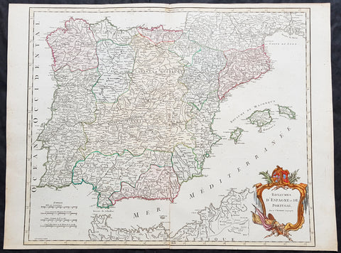
1757 Robert De Vaugondy Large Antique Map Spain, Portugal & The Balearic Islands
- Title : 1757 Robert De Vaugondy Large Antique Map Spain, Portugal & The Balearic Islands
- Size: 26in x 20in (660mm x 510mm)
- Condition: (A+) Fine Condition
- Date : 1757
- Ref #: 41585
Description:
This magnificent hand coloured original copper-plate engraved antique map of Spain, Portugal & The Balearic Islands by Robert De Vaugondy was published in the 1757 edition of De Vaugondys famous The Atlas Universel
General Definitions:
Paper thickness and quality: - Heavy and stable
Paper color : - off white
Age of map color: - Original & later
Colors used: - Blue, pink, red, green, yellow
General color appearance: - Authentic
Paper size: - 26in x 20in (660mm x 510mm)
Plate size: - 21in x 19 1/2in (535mm x 495mm)
Margins: - Min 1/4in (5mm)
Imperfections:
Margins: - None
Plate area: - None
Verso: - None
Background:
Many of the original charts and maps drawn by the first Portuguese and Spanish navigators have survived for the very good reason that, on completion of their voyages, pilots were obliged to hand over their manuscript notes to the Casa da India (founded 1504) in Lisbon or to the equivalent Casa de Contrataci6n de las Indias (founded 1504) in Seville. The clear intention was to maintain secrecy over new discoveries and control over the distribution of cartographic material, not always successfully, as it happened; pilots and navigators seem to have changed allegiance with impunity and, in consequence, many of the earliest and most informative charts were compiled as far away as Genoa, Venice, Florence and Ancona, presumably from sources outside the Portuguese and Spanish \\\'Casas\\\'.It is apparent that few manuscripts reached the printing stage and, indeed, are so rare that any study of them must be regarded as a specialist subject. (Ref Tooley M&B)
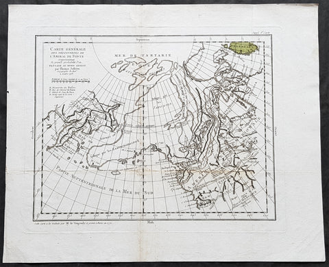
1772 Robert De Vaugondy & Diderot Antique Map of America - California to Alaska
- Title : Carte Generale Des Decouvertes De L Amiral De Fonte representant la grande probabilite d\'un Passage au Nord Ouestg par Thomas Jefferys . . . 1768
- Size: 19in x 15 3/4in (480mm x 400mm)
- Condition: (A) Very Good Condition
- Date : 1772
- Ref #: 30844
Description:
This magnificent original copper-plate engraved antique map of the NW coast of America based upon the Thomas Jefferys map of 1768, by Robert De Vaugondy in 1772, by Robert De Vaugondy was engraved in 1772 - the date is engraved at the foot of the map - and published in the 1775 edition of Denis Diderots (1713-84) Encyclopédie, ou dictionnaire raisonné des sciences, des arts et des métiers (Encyclopedia, or a Systematic Dictionary of the Sciences, Arts, and Crafts).
Denis Diderot 1713 – 1784 was a French philosopher, art critic, and writer, best known for serving as co-founder, chief editor, and contributor to the Encyclopédie along with Jean le Rond d Alembert. He was a prominent figure during the Enlightenment.
Diderot began his education by obtaining a Master of Arts degree in philosophy at a Jesuit college in 1732. He considered working in the church clergy before briefly studying law. When he decided to become a writer in 1734, his father disowned him for not entering one of the learned professions. He lived a bohemian existence for the next decade. He befriended philosopher Jean-Jacques Rousseau in 1742.
Though his work was broad as well as rigorous, it did not bring Diderot riches. He secured none of the posts that were occasionally given to needy men of letters; he could not even obtain the bare official recognition of merit that was implied by being chosen a member of the Académie française. He saw no alternative to selling his library to provide a dowry for his daughter. Empress Catherine II of Russia heard of his financial troubles and commissioned an agent in Paris to buy the library. She then requested that the philosopher retain the books in Paris until she required them, and act as her librarian with a yearly salary. Between October 1773 and March 1774, the sick Diderot spent a few months at the empress\'s court in Saint Petersburg.
Diderot died of pulmonary thrombosis in Paris on 31 July 1784, and was buried in the city\'s Église Saint-Roch. His heirs sent his vast library to Catherine II, who had it deposited at the National Library of Russia. He has several times been denied burial in the Panthéon with other French notables. The French government considered memorializing him in this fashion on the 300th anniversary of his birth, but this did not come to pass.
Diderot\'s literary reputation during his lifetime rested primarily on his plays and his contributions to the Encyclopédie; many of his most important works, including Jacques the Fatalist, Rameaus Nephew, Paradox of the Actor, and D Alembert\'s Dream, were published only after his death.
General Definitions:
Paper thickness and quality: - Heavy and stable
Paper color : - off white
Age of map color: - Original
Colors used: - Yellow, green, blue, pink
General color appearance: - Authentic
Paper size: - 16 1/2in x 13in (420mm x 330mm)
Plate size: - 16in x 12 1/2in (405mm x 315mm)
Margins: - Min 1/2in (10mm)
Imperfections:
Margins: - None
Plate area: - None
Verso: - None
Background:
Interesting map of the NW Coast of America and the NE Coast of Asia, based upon the Thomas Jefferys map of 1768.
Prior to Cooks 1st Voyage, the English, French and Russians were actively debating the cartography of the region in the North Pacific between Asia and North America. The Russian explorations of the first half of the 18th Century, including those by Behring, Tchirikow and others, had been reported by JN De L Isle, who had worked with the Russians and was privy to their latest discoveries. The mythical voyages of De Fuca, d Aguilar and De Font were still very much in evidence in contemporary cartography, as were concepts of a NW Passage, the Sea of the West, River of the West and other vestiges of 16th and 17th Century conjectural/mythical cartography.
Following the publication by Buache of his maps on the region, the debate between the French and English was quite fertile, so much so that Diderot dedicated most of his 10 map supplments to the region.
This map shows the Jefferys model, including a wide De Fuca based River from Puget Sound to the Atlantic over Hudson\'s Bay, several significant rivers flowing from the Pacific to the middle of North America, and Jesuit based water passages from the Pacific to the Arctic Seas. A marvelous approximation of Alaskan Archipelago is shown, along with the Russian discoveries. (Ref: Tooley; M&B)
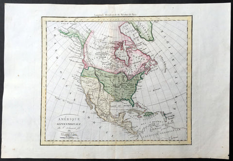
1811 Delamarche Antique Map of North America, Russian Alaska
- Title : Amerique Septentrionale Par F Delmarche fils 1811
- Ref #: 35093
- Size: 18in x 12 1/2in (460mm x 310mm)
- Date : 1811
- Condition: (A+) Fine Condition
Description:
This beautifully hand coloured original antique Map of North America by Robert De Vaugondy was published by Charles Francois Delamarche, De Vaugondy's successor, in 1811 - dated in the title.
Great early 19th century map of North America showing French Spanish and English possessions of North America. Alaska is shown as Russian Territory. (Ref: Tooley; M&B)
General Description:
Paper thickness and quality: - Heavy and stable
Paper color: - White
Age of map color: - Early
Colors used: - Pink, green, blue, yellow
General color appearance: - Authentic
Paper Size: - 18in x 12 1/2in (460mm x 310mm)
Plate size: - 13in x 11 3/4in (330mm x 280mm)
Margins: - Min 1in (25mm)
Imperfections:
Margins: - None
Plate area: - None
Verso: - None
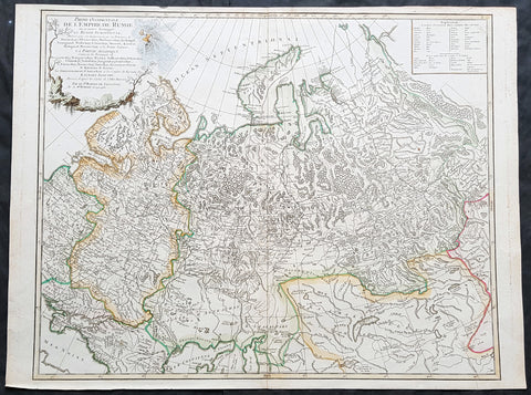
1757 Robert De Vaugondy Large Antique Map of the Russian Empire - Poland to Asia
- Title : Partie Occidentale De L Empire De Russie...Sr Robert De Vaugondy
- Size: 26in x 20in (660mm x 510mm)
- Condition: (A+) Fine Condition
- Date : 1757
- Ref #: 41592
Description:
This large magnificent hand coloured original copper-plate engraved antique map of The Russian Empire - stretching from Poland to Central Asia - by Robert De Vaugondy was published in the 1757 edition of De Vaugondys famous The Atlas Universel
General Definitions:
Paper thickness and quality: - Heavy and stable
Paper color : - off white
Age of map color: - Original & later
Colors used: - Blue, pink, red, green, yellow
General color appearance: - Authentic
Paper size: - 23 1/2in x 19 1/2in (600mm x 495mm)
Plate size: - 23in x 19 1/2in (585mm x 495mm)
Margins: - Min 1/4in (5mm)
Imperfections:
Margins: - None
Plate area: - None
Verso: - None
It is scarcely necessary to look at a map of Russia - with which we must include Siberia - to visualize the daunting task facing Russian map makers. Indeed, considering the vastness of their territory and the lack of skilled cartographers, it is surprising that relatively good maps were available for engraving and printing in most of the well known sixteenth and seventeenth century atlases. Generally, maps of that time were based on material brought back from Moscow by visitors from the West. (Ref Tooley M&B)
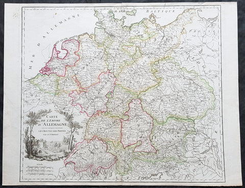
1757 Robert De Vaugondy Large Antique Map of the German States, Bohemia, Austria
- Title : Carte De L Empire D Allemagne..Les Routes Des Postes
- Size: 26in x 19 1/2in (660mm x 495mm)
- Condition: (A+) Fine Condition
- Date : 1757
- Ref #: 41567
Description:
This large magnificent hand coloured original copper-plate engraved antique map of various individual states of Germany including Austria, Bohemia, Switzerland & The Netherlands by Robert De Vaugondy was published in the 1757 edition of De Vaugondys famous The Atlas Universel
General Definitions:
Paper thickness and quality: - Heavy and stable
Paper color : - off white
Age of map color: - Original & later
Colors used: - Blue, pink, red, green, yellow
General color appearance: - Authentic
Paper size: - 26in x 19 1/2in (660mm x 495mm)
Plate size: - 22 1/2in x 19 1/2in (570mm x 495mm)
Margins: - Min 1/4in (5mm)
Imperfections:
Margins: - None
Plate area: - None
Verso: - None
Background:
In the 18th century, the Holy Roman Empire consisted of approximately 1,800 territories. The elaborate legal system initiated by a series of Imperial Reforms (approximately 1450–1555) created the Imperial Estates and provided for considerable local autonomy among ecclesiastical, secular, and hereditary states, reflected in Imperial Diet. The House of Habsburg held the imperial crown from 1438 until the death of Charles VI in 1740. Having no male heirs, he had convinced the Electors to retain Habsburg hegemony in the office of the emperor by agreeing to the Pragmatic Sanction. This was finally settled through the War of Austrian Succession; in the Treaty of Aix-la-Chapelle, Charles VI\'s daughter Maria Theresa ruled the Empire as Empress Consort when her husband, Francis I, became Holy Roman Emperor. From 1740, the dualism between the Austrian Habsburg Monarchy and the Kingdom of Prussia dominated the German history.
In 1772, then again in 1793 and 1795, the two dominant German states of Prussia and Austria, along with the Russian Empire, agreed to the Partitions of Poland; dividing among themselves the lands of the Polish–Lithuanian Commonwealth. As a result of the partitions, millions of Polish speaking inhabitants fell under the rule of the two German monarchies. However, the annexed territories though incorporated into the Kingdom of Prussia and the Habsburg Realm, were not legally considered as a part of the Holy Roman Empire. During the period of the French Revolutionary Wars, along with the arrival of the Napoleonic era and the subsequent final meeting of the Imperial Diet, most of the secular Free Imperial Cities were annexed by dynastic territories; the ecclesiastical territories were secularised and annexed. In 1806 the Imperium was dissolved; many German states, particularly the Rhineland states, fell under the influence of France. Until 1815, France, Russia, Prussia and the Habsburgs (Austria) competed for hegemony in the German states during the Napoleonic Wars
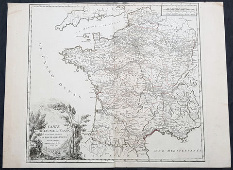
1758 Robert De Vaugondy Large Antique Map of France and Postal Roads
- Title : Carte Du Royame de France ou sont tracees exactement Les Routes Des Postes...1758
- Size: 25 1/2in x 19 1/2in (650mm x 495mm)
- Condition: (A) Very Good Condition
- Date : 1758
- Ref #: 15819
Description:
This large original hand coloured, antique map of France and the postal roads of the day was engraved in 1758 - the date is engraved in the title cartouche - and published by Robert Du Vaugondy in his Atlas Universal, Paris 1757.
General Definitions:
Paper thickness and quality: - Heavy and stable
Paper color : - off white
Age of map color: - Original
Colors used: - Yellow, green, pink
General color appearance: - Authentic
Paper size: - 25 1/2in x 19 1/2in (650mm x 495mm)
Plate size: - 21in x 19 1/2in (535mm x 495mm)
Margins: - Min 1/4in (5mm)
Imperfections:
Margins: - Light age toning
Plate area: - None
Verso: - None
Background:
The Carolingian dynasty ruled France until 987, when Hugh Capet, Duke of France and Count of Paris, was crowned King of the Franks. His descendants—the Capetians, the House of Valois, and the House of Bourbon—progressively unified the country through wars and dynastic inheritance into the Kingdom of France, which was fully declared in 1190 by Philip II Augustus. The French nobility played a prominent role in most Crusades in order to restore Christian access to the Holy Land. French knights made up the bulk of the steady flow of reinforcements throughout the two-hundred-year span of the Crusades, in such a fashion that the Arabs uniformly referred to the crusaders as Franj caring little whether they really came from France. The French Crusaders also imported the French language into the Levant, making French the base of the lingua franca (litt. Frankish language) of the Crusader states. French knights also made up the majority in both the Hospital and the Temple orders. The latter, in particular, held numerous properties throughout France and by the 13th century were the principal bankers for the French crown, until Philip IV annihilated the order in 1307. The Albigensian Crusade was launched in 1209 to eliminate the heretical Cathars in the southwestern area of modern-day France. In the end, the Cathars were exterminated and the autonomous County of Toulouse was annexed into the crown lands of France. Later kings expanded their domain to cover over half of modern continental France, including most of the north, centre and west of France. Meanwhile, the royal authority became more and more assertive, centred on a hierarchically conceived society distinguishing nobility, clergy, and commoners.
From the 11th century, the House of Plantagenet, the rulers of the County of Anjou, succeeded in establishing its dominion over the surrounding provinces of Maine and Touraine, then progressively built an empire that spanned from England to the Pyrenees and covering half of modern France. Tensions between the kingdom of France and the Plantagenet empire would last a hundred years, until Philip Augustus of France conquered between 1202 and 1214 most of the continental possessions of the empire, leaving England and Aquitaine to the Plantagenets. Following the Battle of Bouvines, the Angevin court retreated to England, but persistent Capetian–Plantagenet rivalry would paved the way for another conflict.
Charles IV the Fair died without an heir in 1328. Under the rules of the Salic law the crown of France could not pass to a woman nor could the line of kingship pass through the female line. Accordingly, the crown passed to Philip of Valois, a cousin of Charles, rather than through the female line to Charles nephew, Edward of Plantagenet, who would soon become Edward III of England. During the reign of Philip of Valois, the French monarchy reached the height of its medieval power. Philips seat on the throne was contested by Edward III of England and in 1337, on the eve of the first wave of the Black Death, England and France went to war in what would become known as the Hundred Years War. The exact boundaries changed greatly with time, but French landholdings of the English Kings remained extensive for decades. With charismatic leaders, such as Joan of Arc and La Hire, strong French counterattacks won back English continental territories. Like the rest of Europe, France was struck by the Black Death; half of the 17 million population of France died.
The French Renaissance saw a spectacular cultural development and the first standardisation of the French language, which would become the official language of France and the language of Europes aristocracy. It also saw a long set of wars, known as the Italian Wars, between France and the House of Habsburg. French explorers, such as Jacques Cartier or Samuel de Champlain, claimed lands in the Americas for France, paving the way for the expansion of the First French colonial empire. The rise of Protestantism in Europe led France to a civil war known as the French Wars of Religion, where, in the most notorious incident, thousands of Huguenots were murdered in the St. Bartholomews Day massacre of 1572. The Wars of Religion were ended by Henry IVs Edict of Nantes, which granted some freedom of religion to the Huguenots. Spanish troops, the terror of Western Europe, assisted the Catholic side during the Wars of Religion in 1589–1594, and invaded northern France in 1597; after some skirmishing in the 1620s and 1630s, Spain and France returned to all-out war between 1635 and 1659. The war cost France 300,000 casualties.
Under Louis XIII, the energetic Cardinal Richelieu promoted the centralisation of the state and reinforced the royal power by disarming domestic power holders in the 1620s. He systematically destroyed castles of defiant lords and denounced the use of private violence (dueling, carrying weapons, and maintaining private army). By the end of 1620s, Richelieu established the royal monopoly of force as the doctrine. During Louis XIVs minority and the regency of Queen Anne and Cardinal Mazarin, a period of trouble known as the Fronde occurred in France. This rebellion was driven by the great feudal lords and sovereign courts as a reaction to the rise of royal absolute power in France.
The monarchy reached its peak during the 17th century and the reign of Louis XIV. By turning powerful feudal lords into courtiers at the Palace of Versailles, Louis XIVs personal power became unchallenged. Remembered for his numerous wars, he made France the leading European power. France became the most populous country in Europe and had tremendous influence over European politics, economy, and culture. French became the most-used language in diplomacy, science, literature and international affairs, and remained so until the 20th century. France obtained many overseas possessions in the Americas, Africa and Asia. Louis XIV also revoked the Edict of Nantes, forcing thousands of Huguenots into exile.
Under Louis XV, Louis XIVs great-grandson, France lost New France and most of its Indian possessions after its defeat in the Seven Years War (1756–63). Its European territory kept growing, however, with notable acquisitions such as Lorraine (1766) and Corsica (1770). An unpopular king, Louis XVs weak rule, his ill-advised financial, political and military decisions – as well as the debauchery of his court– discredited the monarchy, which arguably paved the way for the French Revolution 15 years after his death.
Louis XVI, Louis XVs grandson, actively supported the Americans, who were seeking their independence from Great Britain (realised in the Treaty of Paris (1783)). The financial crisis aggravated by Frances involvement in the American Revolutionary War was one of many contributing factors to the French Revolution. Much of the Enlightenment occurred in French intellectual circles, and major scientific breakthroughs and inventions, such as the discovery of oxygen (1778) and the first hot air balloon carrying passengers (1783), were achieved by French scientists. French explorers, such as Bougainville and Lapérouse, took part in the voyages of scientific exploration through maritime expeditions around the globe. The Enlightenment philosophy, in which reason is advocated as the primary source for legitimacy and authority, undermined the power of and support for the monarchy and helped pave the way for the French Revolution.
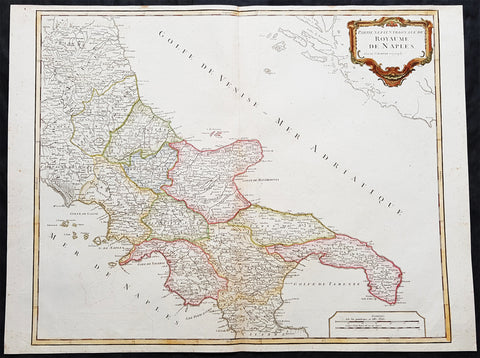
1757 Robert De Vaugondy Large Antique Map Southern Italy Mezzogiorno, 2 Sicilies
- Title : Partie Septentrionale Du Royaume De Naples
- Size: 26in x 19 1/2in (660mm x 495mm)
- Condition: (A+) Fine Condition
- Date : 1757
- Ref #: 92771
Description:
This magnificent hand coloured original copper-plate engraved antique map of Southern Italy in the mid to late 18th century by Robert De Vaugondy was published in the 1757 edition of De Vaugondys famous The Atlas Universel
General Definitions:
Paper thickness and quality: - Heavy and stable
Paper color : - off white
Age of map color: - Original & later
Colors used: - Blue, pink, red, green, yellow
General color appearance: - Authentic
Paper size: - 26in x 19 1/2in (660mm x 495mm)
Plate size: - 24 1/2in x 19 1/2in (620mm x 495mm)
Margins: - Min 1/4in (5mm)
Imperfections:
Margins: - None
Plate area: - None
Verso: - None
Background:
Southern Italy or Mezzogiorno is a macroregion of Italy traditionally encompassing the territories of the former Kingdom of the two Sicilies (all the southern section of the Italian Peninsula and Sicily), with the frequent addition of the island of Sardinia.
In 1442, however, Alfonso V conquered the Kingdom of Naples and unified Sicily and Naples once again as dependencies of the Crown of Aragon. At his death in 1458, the kingdom was again separated and Naples was inherited by Ferrante, Alfonso\'s illegitimate son. When Ferrante died in 1494, Charles VIII of France invaded Italy, using the Angevin claim to the throne of Naples, which his father had inherited on the death of King René\'s nephew in 1481, as a pretext, thus beginning the Italian Wars. Charles VIII expelled Alfonso II of Naples from Naples in 1495, but was soon forced to withdraw due to the support of Ferdinand II of Aragon for his cousin, Alfonso IIs son Ferrantino. Ferrantino was restored to the throne, but died in 1496, and was succeeded by his uncle, Frederick IV. The French, however, did not give up their claim, and in 1501 agreed to a partition of the kingdom with Ferdinand of Aragon, who abandoned his cousin King Frederick. The deal soon fell through, however, and the Crown of Aragon and France resumed their war over the kingdom, ultimately resulting in an Aragonese victory leaving Ferdinand in control of the kingdom by 1504.
The kingdom continued to be a focus of dispute between France and Spain for the next several decades, but French efforts to gain control of it became feebler as the decades went on, and Spanish control was never genuinely endangered. The French finally abandoned their claims to the kingdom by the Treaty of Cateau-Cambrésis in 1559. With the Treaty of London (1557) the new client state of Stato dei Presidi (State of Presidi) was established and governed directly by Spain, as part of the Kingdom of Naples.
The administration of the Kingdom of Naples and Sicily, as well as the Duchy of Milan, was then run by the Council of Italy, while Sardinia kept being an integral part of the Council of Aragon until the first years of the XVIII° century, when it was ceded to Austria and eventually Savoy.
After the War of the Spanish Succession in the early 18th century, possession of the kingdom again changed hands. Under the terms of the Treaty of Utrecht in 1713, Naples was given to Charles VI, the Holy Roman Emperor. He also gained control of Sicily in 1720, but Austrian rule did not last long. Both Naples and Sicily were conquered by a Spanish army during the War of the Polish Succession in 1734, and Charles, Duke of Parma, a younger son of King Philip V of Spain was installed as King of Naples and Sicily from 1735. When Charles inherited the Spanish throne from his older half-brother in 1759, he left Naples and Sicily to his younger son, Ferdinand IV. Despite the two kingdoms being in a personal union under the House of Bourbon from 1735 onwards, they remained constitutionally separated.
Being a member of the House of Bourbon, King Ferdinand IV was a natural opponent of the French Revolution and Napoleon. In January 1799, Napoleon Bonaparte, in the name of the French Republic, captured Naples and proclaimed the Parthenopaean Republic, a French client state, as successor to the kingdom. King Ferdinand fled from Naples to Sicily until June of that year. In 1806, Bonaparte, by then French Emperor, again dethroned King Ferdinand and appointed his brother, Joseph Bonaparte, as King of Naples. In the Edict of Bayonne of 1808, Napoleon removed Joseph to Spain and appointed his brother-in-law, Joachim Murat, as King of the Two Sicilies, though this meant control only of the mainland portion of the kingdom. Throughout this Napoleonic interruption, King Ferdinand remained in Sicily, with Palermo as his capital.
After Napoleon\'s defeat, King Ferdinand IV was restored by the Congress of Vienna of 1815 as Ferdinand I of the Two Sicilies. He established a concordat with the Papal States, which previously had a claim to the land. There were several rebellions on the island of Sicily against the King Ferdinand II but the end of the kingdom was only brought about by the Expedition of the Thousand in 1860, led by Garibaldi, an icon of the Italian unification, with the support of the House of Savoy and their Kingdom of Sardinia. The expedition resulted in a striking series of defeats for the Sicilian armies against the growing troops of Garibaldi. After the capture of Palermo and Sicily, he disembarked in Calabria and moved towards Naples, while in the meantime the Piedmontese also invaded the Kingdom from the Marche. The last battles fought were that of the Volturnus in 1860 and the siege of Gaeta, where King Francis II had sought shelter, hoping for French help, which never came. The last towns to resist Garibaldi\'s expedition were Messina (which capitulated on 13 March 1861) and Civitella del Tronto (which capitulated on 20 March 1861). The Kingdom of the Two Sicilies was dissolved and annexed to the new Kingdom of Italy, founded in the same year. (Ref: Tooley; M&B)
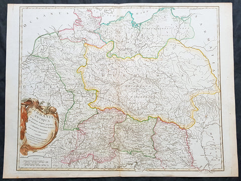
1757 Robert De Vaugondy Large Antique Map of Germania, Germany During Roman Era
- Title : Germania Antiqua in quatuor magnos populos...Autore Robert De Vaugondy
- Size: 26in x 19 1/2in (660mm x 495mm)
- Condition: (A+) Fine Condition
- Date : 1757
- Ref #: 41548
Description:
This large magnificent hand coloured original copper-plate engraved antique map of Ancient Germania, Germany, during the Roman Era by Robert De Vaugondy was published in the 1757 edition of De Vaugondys famous The Atlas Universel
General Definitions:
Paper thickness and quality: - Heavy and stable
Paper color : - off white
Age of map color: - Original & later
Colors used: - Blue, pink, red, green, yellow
General color appearance: - Authentic
Paper size: - 26in x 19 1/2in (660mm x 495mm)
Plate size: - 22 1/2in x 19 1/2in (570mm x 495mm)
Margins: - Min 1/4in (5mm)
Imperfections:
Margins: - None
Plate area: - None
Verso: - None
Background:
Germania was the Roman term for the geographical region in north-central Europe inhabited mainly by Germanic peoples.
It extended from the Danube in the south to the Baltic Sea, and from the Rhine in the west to the Vistula. The Roman portions formed two provinces of the Empire, Germania Inferior to the north (present-day southern Netherlands, Belgium, and western Germany), and Germania Superior to the south (Switzerland, southwestern Germany, and eastern France).
Germania was inhabited mostly by Germanic tribes, but also Celts, Balts, Scythians and later on Early Slavs. The population mix changed over time by assimilation, and especially by migration. The ancient Greeks were the first to mention the tribes in the area. Later, Julius Caesar wrote about warlike Germanic tribesmen and their threat to Roman Gaul, and there were military clashes between the Romans and the indigenous tribes. Tacitus wrote the most complete account of Germania that still survives.
The origin of the term Germania is uncertain, but was known by Caesar\'s time, and may be Gaulish in origin.
Germania was inhabited by different tribes, most of them Germanic but also some Celtic, proto-Slavic, Baltic and Scythian peoples. The tribal and ethnic makeup changed over the centuries as a result of assimilation and, most importantly, migrations. The Germanic people spoke several different dialects.
Classical records show little about the people who inhabited the north of Europe before the 2nd century BC. In the 5th century BC, the Greeks were aware of a group they called Celts (Keltoi). Herodotus also mentioned the Scythians but no other tribes. At around 320 BC, Pytheas of Massalia sailed around Britain and along the northern coast of Europe, and what he found on his journeys was so strange that later writers refused to believe him. He may have been the first Mediterranean to distinguish the Germanic people from the Celts. Contact between German tribes and the Roman Empire did take place and was not always hostile. Recent excavations of the Waldgirmes Forum show signs that a civilian Roman town was established there, which has been interpreted to mean that Romans and Germanic tribesmen were living in peace, at least for a while.
Caesar described the cultural differences between the Germanic tribesmen, the Romans, and the Gauls in his book Commentarii de Bello Gallico, where he recalls his defeat of the Suebi tribes at the Battle of Vosges. He describes them at length at the beginning of Book IV and the middle of Book VI. He states that the Gauls, although warlike, had a functional society and could be civilized, but that the Germanic tribesmen were far more savage and were a threat to Roman Gaul and Rome itself. Caesar said the Germanic tribes were nomadic, with no notable settlements and a primitive culture. He used this as one of his justifications for why they had to be conquered. His accounts of barbaric northern tribes could be described as an expression of the superiority of Rome, including Roman Gaul.
Caesars accounts portray the Roman fear of the Germanic tribes and the threat they posed. The perceived menace of the Germanic tribesmen proved accurate. The most complete account of Germania that has been preserved from Roman times is Tacitus Germania.
1757 Robert De Vaugondy Large Antique Map of Franconia, Franken Southern Germany
- Title : Cercle De Franconie.....Par Le Sr. Robert
- Size: 26 1/2in x 19 3/4in (670mm x 505mm)
- Condition: (A+) Fine Condition
- Date : 1757
- Ref #: 41575
Description:
This large magnificent hand coloured original copper-plate engraved antique map of Franconia or Franken south central Germany by Robert De Vaugondy was published in the 1757 edition of De Vaugondys famous The Atlas Universel
General Definitions:
Paper thickness and quality: - Heavy and stable
Paper color : - off white
Age of map color: - Original & later
Colors used: - Blue, pink, red, green, yellow
General color appearance: - Authentic
Paper size: - 26 1/2in x 19 3/4in (670mm x 505mm)
Plate size: - 22 3/4in x 19in (580mm x 490mm)
Margins: - Min 1/2in (10mm)
Imperfections:
Margins: - None
Plate area: - None
Verso: - None
Background:
Franconia is a region in Germany, characterised by its culture and language, and may be roughly associated with the areas in which the East Franconian dialect group, locally referred to as fränkisch, is spoken. It commonly refers to the eastern part of the historical Franconian stem duchy, mainly represented by the modern Bavarian administrative districts of Lower, Middle, and Upper Franconia, the adjacent northeastern parts of Heilbronn-Franken in Baden-Württemberg, parts of Thuringia south of the Rennsteig ridge, and small parts of Hesse. Sometimes Vogtland is also regarded as part of Franconia (because the Vogtländisch dialect is often regarded as sub-group of East Franconian) but this is disputed. However, there is no fixed area that is officially defined as Franconia.
On 2 July 1500 during the reign of Emperor Maximilian I, as part of the Imperial Reform Movement, the Empire was divided into Imperial Circles. This led in 1512 to the formation of the Franconian Circle. Seen from a modern perspective, the Franconian Circle may be viewed as an important basis for the sense of a common Franconian identity that exists today. The Franconian Circle also shaped the geographical limits of the present-day Franconia. In the late Middle Ages and Early Modern Period, the Imperial Circle was severely affected by Kleinstaaterei, the patchwork of tiny states in this region of Germany. As during the late Middle Ages, the bishops of Würzburg used the nominal title of Duke of Franconia during the time of the Imperial Circle. In 1559, the Franconian Circle was given jurisdiction over coinage (Münzaufsicht) and, in 1572, was the only Circle to issue its own police ordinance.
Members of the Franconian Circle included the imperial cities, the prince-bishoprics, the Bailiwick of Franconia of the Teutonic Order and several counties. The Imperial Knights with their tiny territories, of which there was a particularly large number in Franconia, were outside the Circle assembly and, until 1806, formed the Franconian Knights Circle (Fränkischer Ritterkreis) consisting of six Knights\' Cantons. Because the extent of Franconia, already referred to above, is disputed, there were many areas that might be counted as part of Franconia today, that lay outside the Franconian Circle. For example, the area of Aschaffenburg belonged to Electoral Mainz and was a part of the Electoral Rhenish Circle, the area of Coburg belonged to the Upper Saxon Circle and the Heilbronn area to the Swabian Circle. In the 16th century, the College of Franconian Counts was founded to represent the interests of the counts in Franconia.
Franconia played an important role in the spread of the Reformation initiated by Martin Luther, Nuremberg being one of the places where the Luther Bible was printed. The majority of other Franconian imperial cities and imperial knights embraced the new confession. In the course of the counter-reformation several regions of Franconia returned to Catholicism, however, and there was also an increase in witch trials. In addition to Lutheranism, the radical reformatory baptist movement spread early on across the Franconian area. Important Baptist centres were Königsberg and Nuremberg.
In 1525, the burden of heavy taxation and socage combined with new, liberal ideas that chimed with the Reformation movement, unleashed the German Peasants\' War. The Würzburg area was particularly hard hit with numerous castles and monasteries being burned down. In the end, however, the uprisings were suppressed and for centuries the lowest strata of society were excluded from all political activity.
From 1552, Margrave Albert Alcibiades attempted to break the supremacy of the mighty imperial city of Nuremberg and to secularise the ecclesial estates in the Second Margrave War, to create a duchy over which he would rule. Large areas of Franconia were eventually devastated in the fighting until King Ferdinand I together with several dukes and princes decided to overthrow Albert.
In 1608, the reformed princes merged into a so-called Union within the Empire. In Franconia, the margraves of Ansbach and Bayreuth as well as the imperial cities were part of this alliance. The Catholic side responded in 1609 with a counter-alliance, the League. The conflicts between the two camps ultimately resulted in the Thirty Years\' War, which was the greatest strain on the cohesion of the Franconian Circle Initially, Franconia was not a theatre of war, although marauding armies repeatedly crossed its territory. However, in 1631, Swedish troops under Gustavus Adolphus advanced into Franconia and established a large encampment in summer 1632 around Nuremberg. However, the Swedes lost the Battle of the Alte Veste against Wallenstein\'s troops and eventually withdrew. Franconia was one of the poorest regions in the Empire and lost its imperial political significance. During the course of the war, about half the local population lost their lives. To compensate for these losses about 150,000 displaced Protestants settled in Protestant areas, including Austrian exiles.
Franconia never developed into a unified territorial state, because the patchwork quilt of small states (Kleinstaaterei) survived the Middle Ages and lasted until the 18th century. As a result, the Franconian Circle had the important task of preserving peace, preventing abuses and to repairing war damage and had a regulatory role in the region until the end of the Holy Roman Empire. Until the War of the Spanish Succession, the Circle had become an almost independent organization and joined the Grand Alliance against Louis XIV as an almost sovereign state. The Circle also developed early forms of a welfare state. It also played a major role in the control of disease during the 16th and 17th centuries. After Charles Alexander abdicated in 1792, the former margraviates of Ansbach and Bayreuth were annexed by Prussia. Karl August Freiherr von Hardenberg was appointed as governor of these areas by Prussia
Most of modern-day Franconia became part of Bavaria in 1803 thanks to Bavaria\'s alliance with Napoleon. Culturally it is in many ways different from Bavaria proper (Altbayern, Old Bavaria), however. The ancient name was resurrected in 1837 by Ludwig I of Bavaria. During the Nazi period, Bavaria was broken up into several different Gaue, including Franconia and Main-Franconia.
1757 Robert De Vaugondy Large Antique Map of The State of Westphalia, Germany
- Title : Cercle De Westpahlia.......Par Le Sr. Robert
- Size: 26in x 20in (660mm x 510mm)
- Condition: (A+) Fine Condition
- Date : 1757
- Ref #: 41570
Description:
This large magnificent hand coloured original copper-plate engraved antique map of the German State of Westphalia by Robert De Vaugondy was published in the 1757 edition of De Vaugondys famous The Atlas Universel
General Definitions:
Paper thickness and quality: - Heavy and stable
Paper color : - off white
Age of map color: - Original & later
Colors used: - Blue, pink, red, green, yellow
General color appearance: - Authentic
Paper size: - 26in x 20in (660mm x 510mm)
Plate size: - 25in x 19in (635mm x 485mm)
Margins: - Min 1/2in (10mm)
Imperfections:
Margins: - None
Plate area: - None
Verso: - None
Background:
Westphalia is a region in northwestern Germany and one of the three historic parts of the state of North Rhine-Westphalia.
Westphalia is known for the 1648 Peace of Westphalia which ended the Thirty Years War, as the two treaties were signed in Münster and Osnabrück.
It is one of the regions that were part of all incarnations of the German state since the Early Middle Ages: the Holy Roman Empire, the Confederation of the Rhine, the German Confederation, the North German Confederation, the German Empire, the Weimar Republic and National Socialist Germany. After World War II it was a part of the British occupation zone which merged with the American zone to become the Bizone in 1947 and again merged with the French zone to become the Trizone in 1948. The current Federal Republic of Germany was founded on these territories making Westphalia a part of West Germany. It is a part of united Germany since 1990.
Along with Eastphalia, Angria and Nordalbingia, Westphalia (Westfalahi) was originally a district of the Duchy of Saxony. At the time, large portions of its territory in the north lay in what today is Lower Saxony. Following the deposition of the Saxon duke Henry the Lion in 1180 and the subsequent belittlement of the duchy, Westphalia was elevated to a duchy in its own right by Emperor Barbarossa. The Duchy of Westphalia comprised only a small area south of the Lippe River.
Modern Westphalia was a part of the Lower Rhenish–Westphalian Circle of the Holy Roman Empire, which comprised territories of Lower Lorraine, Frisia and parts of the former Duchy of Saxony.
As a result of the Protestant Reformation, there was no dominant religion in Westphalia. Roman Catholicism and Lutheranism were on a relatively equal footing. Lutheranism was strong in the eastern and northern parts with numerous free churches. Münster and especially Paderborn were thought of to be Catholic. Osnabrück was divided almost equally between Catholicism and Protestantism.
Parts of Westphalia came under Brandenburg-Prussian control during the 17th and 18th centuries, but most of it remained divided by duchies and other areas of feudal power. The Peace of Westphalia of 1648, signed in Münster and Osnabrück, ended the Thirty Years\' War. The concept of nation-state sovereignty resulting from the treaty became known as Westphalian sovereignty.
1757 Robert De Vaugondy Large Antique Map The County of Hainaut Belgium & France
- Title : Comte De Hainaut et de Cambres.......Par Le Sr. Robert
- Size: 23in x 19 1/2in (585mm x 495mm)
- Condition: (A+) Fine Condition
- Date : 1757
- Ref #: 41564
Description:
This large magnificent hand coloured original copper-plate engraved antique map of the Hainaut region of Belgium - centering on the city of Mons - by Robert De Vaugondy was published in the 1757 edition of De Vaugondys famous The Atlas Universel
General Definitions:
Paper thickness and quality: - Heavy and stable
Paper color : - off white
Age of map color: - Original & later
Colors used: - Blue, pink, red, green, yellow
General color appearance: - Authentic
Paper size: - 23in x 19 1/2in (585mm x 495mm)
Plate size: - 23in x 19 1/2in (585mm x 495mm)
Margins: - Min 1/4in (6mm)
Imperfections:
Margins: - None
Plate area: - None
Verso: - None
Background:
The County of Hainaut sometimes given the spelling Hainault, was a historical lordship within the medieval Holy Roman Empire with its capital eventually established at Mons (Dutch: Bergen), and named after the river Haine, both now in Belgium. Besides Mons, it included the city of Valenciennes, now in France. It consisted of what is now the Belgian province of Hainaut and the eastern part of the French département of Nord.
Originally a gau of Lotharingia, Hainaut was briefly a part of West Francia (911–25) before becoming definitively attached to Germany. The county was divided in 958 and only emerged in its more or less final form in 1071. Hainaut was culturally and linguistically French. In 1432, Hainaut was acquired by the House of Valois-Burgundy and in 1477 passed to the Habsburgs with the rest of the Burgundian Netherlands and became part of the Burgundian Circle in 1512. It was ruled by the Spanish branch of the Habsburgs from 1555 to 1714. In 1659 and 1678 southern Hainaut was acquired by France, and in 1797 the rest of the county was ceded to France by the Emperor Francis II, who was also count of Hainaut.
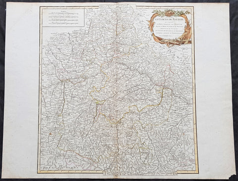
1757 Robert De Vaugondy Large Antique Map of Bavaria & River Danube, Germany
- Title : Le Cercle De Baviere.......Par Le Sr. Robert
- Size: 26in x 20in (660mm x 510mm)
- Condition: (A+) Fine Condition
- Date : 1757
- Ref #: 41577
Description:
This large magnificent hand coloured original copper-plate engraved antique map of Bavaria, Germany - centering on the River Danube - by Robert De Vaugondy was published in the 1757 edition of De Vaugondys famous The Atlas Universel
General Definitions:
Paper thickness and quality: - Heavy and stable
Paper color : - off white
Age of map color: - Original & later
Colors used: - Blue, pink, red, green, yellow
General color appearance: - Authentic
Paper size: - 26in x 20in (660mm x 510mm)
Plate size: - 20in x 19 1/2in (510mm x 495mm)
Margins: - Min 1/2in (10mm)
Imperfections:
Margins: - None
Plate area: - None
Verso: - None
Background:
Bavaria officially the Free State of Bavaria is a landlocked federal state of Germany, occupying its southeastern corner. With an area of 70,550.19 square kilometres, Bavaria is the largest German state by land area. Its territory comprises roughly a fifth of the total land area of Germany. With 12.9 million inhabitants, it is Germany\'s second-most-populous state after North Rhine-Westphalia. Bavaria\'s capital and largest city, Munich, is the third-largest city in Germany.
The history of Bavaria stretches from its earliest settlement and formation as a duchy in the 6th century CE through the Holy Roman Empire to becoming an independent kingdom and a state of the Federal Republic of Germany.
The Duchy of Bavaria dates back to the year 555. In the 17th century CE, the Duke of Bavaria became a Prince-elector of the Holy Roman Empire. The Kingdom of Bavaria existed from 1806 to 1918, when Bavaria became a republic. In 1946, the Free State of Bavaria re-organised itself on democratic lines after the Second World War.
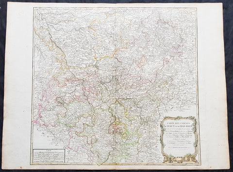
1757 Robert De Vaugondy Large Antique Map of North Rhine-Westphalia Bonn Cologne
- Title : Carte Des Cercles Du Haut et du Bas Rhin.....Par Le Sr. Robert
- Size: 26 1/2in x 19 3/4in (670mm x 505mm)
- Condition: (A+) Fine Condition
- Date : 1757
- Ref #: 41574
Description:
This large magnificent hand coloured original copper-plate engraved antique map of part of Western Germany centering on the Rhine River and the cities of Bonn & Cologne, today the North Rhine-Westphalia by Robert De Vaugondy was published in the 1757 edition of De Vaugondys famous The Atlas Universel
General Definitions:
Paper thickness and quality: - Heavy and stable
Paper color : - off white
Age of map color: - Original & later
Colors used: - Blue, pink, red, green, yellow
General color appearance: - Authentic
Paper size: - 26 1/2in x 19 3/4in (670mm x 505mm)
Plate size: - 21 1/2in x 19in (550mm x 480mm)
Margins: - Min 1/2in (10mm)
Imperfections:
Margins: - None
Plate area: - None
Verso: - None
Background:
North Rhine-Westphalia is located in western Germany covering an area of 34,084 square kilometres and a population of 17.6 million, the most populous and the most densely populated German state apart from the city-states of Berlin, Bremen, and Hamburg, and the fourth-largest by area. Düsseldorf is the state capital and Cologne is the largest city. North Rhine-Westphalia features four of Germany\'s 10 largest cities: Düsseldorf, Cologne, Dortmund, and Essen, and the Rhine-Ruhr metropolitan area, the largest in Germany and the third-largest on the European continent.
Around AD 1, numerous incursions occurred through Westphalia and perhaps even some permanent Roman or Romanized settlements. The Battle of Teutoburg Forest took place near Osnabrück (as mentioned, whether this is in Westphalia is disputed) and some of the Germanic tribes who fought at this battle came from the area of Westphalia. Charlemagne is thought to have spent considerable time in Paderborn and nearby parts. His Saxon Wars also partly took place in what is thought of as Westphalia today. Popular legends link his adversary Widukind to places near Detmold, Bielefeld, Lemgo, Osnabrück, and other places in Westphalia. Widukind was buried in Enger, which is also a subject of a legend.
Along with Eastphalia and Engern, Westphalia (Westfalahi) was originally a district of the Duchy of Saxony. In 1180, Westphalia was elevated to the rank of a duchy by Emperor Barbarossa. The Duchy of Westphalia comprised only a small area south of the Lippe River.
Parts of Westphalia came under Brandenburg-Prussian control during the 17th and 18th centuries, but most of it remained divided duchies and other feudal areas of power. The Peace of Westphalia of 1648, signed in Münster and Osnabrück, ended the Thirty Years\' War. The concept of nation-state sovereignty resulting from the treaty became known as Westphalian sovereignty.
As a result of the Protestant Reformation, there is no dominant religion in Westphalia. Roman Catholicism and Lutheranism are on relatively equal footing. Lutheranism is strong in the eastern and northern parts with numerous free churches. Münster and especially Paderborn are thought of as Catholic. Osnabrück is divided almost equally between Catholicism and Protestantism.
After the defeat of the Prussian Army at the Battle of Jena-Auerstedt, the Treaty of Tilsit in 1807 made the Westphalian territories part of the Kingdom of Westphalia from 1807 to 1813. It was founded by Napoleon and was a French vassal state. This state only shared the name with the historical region; it contained only a relatively small part of Westphalia, consisting instead mostly of Hessian and Eastphalian regions.
After the Congress of Vienna, the Kingdom of Prussia received a large amount of territory in the Westphalian region and created the province of Westphalia in 1815. The northernmost portions of the former kingdom, including the town of Osnabrück, had become part of the states of Hanover and Oldenburg.
The state of North Rhine-Westphalia was established by the British military administration\'s \"Operation Marriage\" on 23 August 1946, by merging the province of Westphalia and the northern parts of the Rhine Province, both being political divisions of the former state of Prussia within the German Reich. On 21 January 1947, the former state of Lippe was merged with North Rhine-Westphalia. The constitution of North Rhine-Westphalia was then ratified through a referendum.
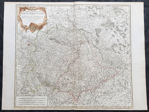
1757 Robert De Vaugondy Large Antique Map of Saxony, Meissen, Thuringia, Leipzig
- Title : Partie Meridionale Du Cercle De Haute Saxe...Par Le Sr. Robert
- Size: 26in x 20in (660mm x 510mm)
- Condition: (A+) Fine Condition
- Date : 1757
- Ref #: 41573
Description:
This large magnificent hand coloured original copper-plate engraved antique map of part of the Saxony region of Germany, centering on the district of Meissen & Thuringia and the city of Leipzig, by Robert De Vaugondy was published in the 1757 edition of De Vaugondys famous The Atlas Universel
General Definitions:
Paper thickness and quality: - Heavy and stable
Paper color : - off white
Age of map color: - Original & later
Colors used: - Blue, pink, red, green, yellow
General color appearance: - Authentic
Paper size: - 26in x 20in (660mm x 510mm)
Plate size: - 22in x 19 1/2in (560mm x 495mm)
Margins: - Min 1/2in (10mm)
Imperfections:
Margins: - None
Plate area: - None
Verso: - None
Background:
Saxony is a landlocked federal state of Germany, bordering the federal states of Brandenburg, Saxony Anhalt, Thuringia, and Bavaria, as well as the countries of Poland and the Czech Republic. Its capital is Dresden, and its largest city is Leipzig.
Saxony is the 10th-largest of Germany\'s 16 states, with an area of 18,413 square kilometres (7,109 sq mi), and the sixth-most populous, with 4 million people.
The history of the state of Saxony spans more than a millennium. It has been a medieval duchy, an electorate of the Holy Roman Empire, a kingdom, and twice a republic.
The area of the modern state of Saxony should not be confused with Old Saxony, the area inhabited by Saxons. Old Saxony corresponds roughly to the modern German states of Lower Saxony, Saxony-Anhalt, and the Westphalian part of North Rhine-Westphalia.
The territory of the Free State of Saxony became part of the Holy Roman Empire by the 10th century, when the dukes of Saxony were also kings (or emperors) of the Holy Roman Empire, comprising the Ottonian, or Saxon, Dynasty. Around this time, the Billungs, a Saxon noble family, received extensive fields in Saxony. The emperor eventually gave them the title of dukes of Saxony. After Duke Magnus died in 1106, causing the extinction of the male line of Billungs, oversight of the duchy was given to Lothar of Supplinburg, who also became emperor for a short time.
In 1137, control of Saxony passed to the Guelph dynasty, descendants of Wulfhild Billung, eldest daughter of the last Billung duke, and the daughter of Lothar of Supplinburg. In 1180 large portions west of the Weser were ceded to the Bishops of Cologne, while some central parts between the Weser and the Elbe remained with the Guelphs, becoming later the Duchy of Brunswick-Lüneburg. The remaining eastern lands, together with the title of Duke of Saxony, passed to an Ascanian dynasty (descended from Eilika Billung, Wulfhild\'s younger sister) and were divided in 1260 into the two small states of Saxe-Lauenburg and Saxe-Wittenberg. The former state was also named Lower Saxony, the latter Upper Saxony, thence the later names of the two Imperial Circles Saxe-Lauenburg and Saxe-Wittenberg. Both claimed the Saxon electoral privilege for themselves, but the Golden Bull of 1356 accepted only Wittenberg\'s claim, with Lauenburg nevertheless continuing to maintain its claim. In 1422, when the Saxon electoral line of the Ascanians became extinct, the Ascanian Eric V of Saxe-Lauenburg tried to reunite the Saxon duchies.
However, Sigismund, King of the Romans, had already granted Margrave Frederick IV the Warlike of Meissen (House of Wettin) an expectancy of the Saxon electorate in order to remunerate his military support. On 1 August 1425 Sigismund enfeoffed the Wettinian Frederick as Prince-Elector of Saxony, despite the protests of Eric V. Thus the Saxon territories remained permanently separated. The Electorate of Saxony was then merged with the much bigger Wettinian Margraviate of Meissen, however using the higher-ranking name Electorate of Saxony and even the Ascanian coat-of-arms for the entire monarchy. Thus Saxony came to include Dresden and Meissen. In the 18th and 19th centuries Saxe-Lauenburg was colloquially called the Duchy of Lauenburg, which in 1876 merged with Prussia as the Duchy of Lauenburg district.
Saxony-Wittenberg, in modern Saxony-Anhalt, became subject to the margravate of Meissen, ruled by the Wettin dynasty in 1423. This established a new and powerful state, occupying large portions of the present Free State of Saxony, Thuringia, Saxony-Anhalt and Bavaria (Coburg and its environs). Although the centre of this state was far to the southeast of the former Saxony, it came to be referred to as Upper Saxony and then simply Saxony, while the former Saxon territories were now known as Lower Saxony.
In 1485, Saxony was split. A collateral line of the Wettin princes received what later became Thuringia and founded several small states there (see Ernestine duchies). The remaining Saxon state became still more powerful and was known in the 18th century for its cultural achievements, although it was politically weaker than Prussia and Austria, states which oppressed Saxony from the north and south, respectively.
Between 1697 and 1763, the Electors of Saxony were also elected Kings of Poland in personal union.
In 1756, Saxony joined a coalition of Austria, France and Russia against Prussia. Frederick II of Prussia chose to attack preemptively and invaded Saxony in August 1756, precipitating the Third Silesian War (part of the Seven Years\' War). The Prussians quickly defeated Saxony and incorporated the Saxon army into the Prussian army. At the end of the Seven Years\' War, Saxony recovered its independence in the 1763 Treaty of Hubertusburg.