Welcome to Classical Images!
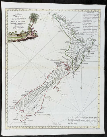
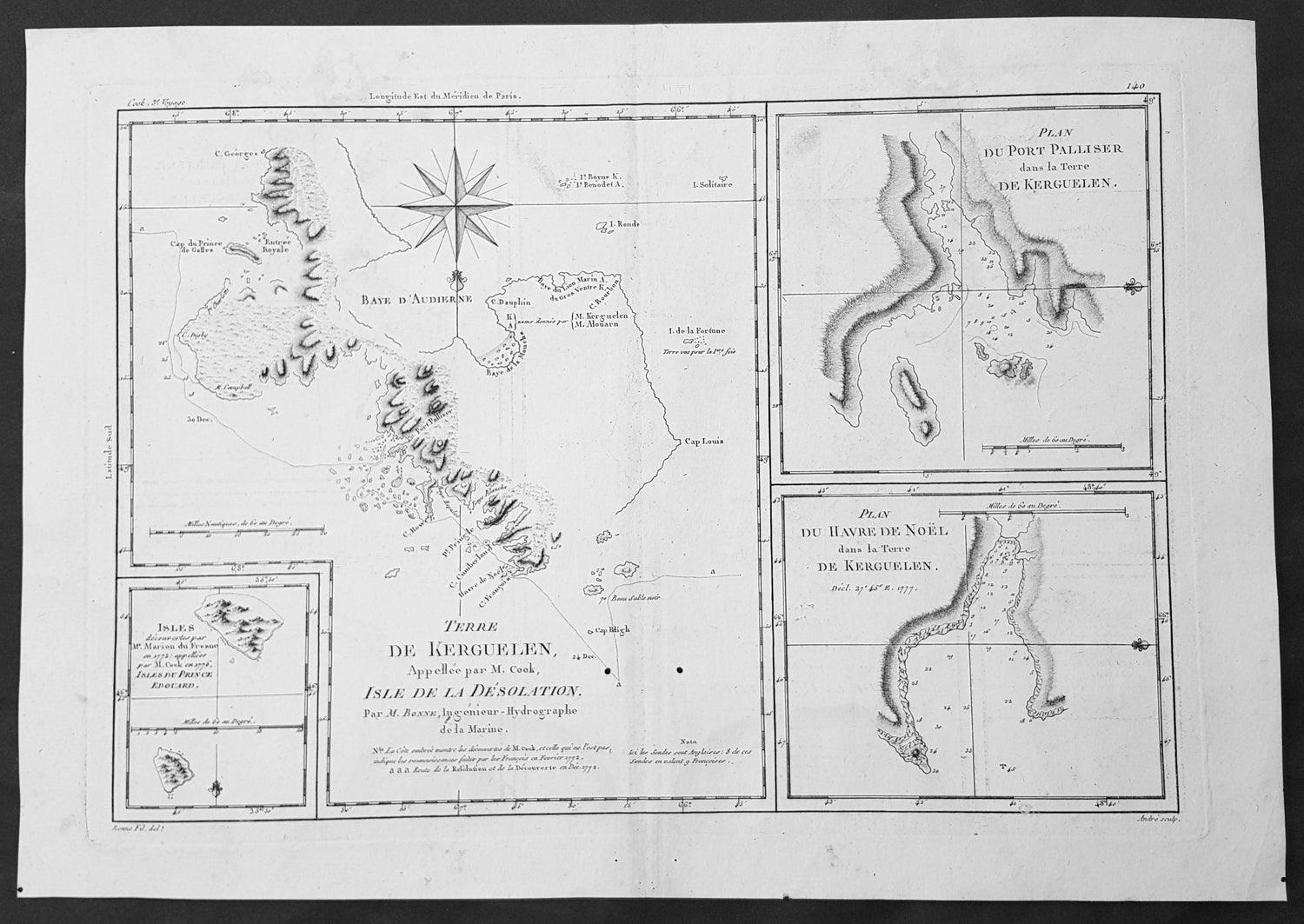
Description:This fine original copper-plate engraved antique map of parts of the Kerguelen Islands, also known as the Desolation Islands, in the southern Indian Ocean, was published in 1780 edition of Atlas des toutes les parties connues du globe terrestre by Rigobert Bonne & Guillaume Raynal.The map also includes three inset maps, the first two of Port Palliser & Noel Bay on Kerguelen Island, with the third inset map of the Prince Edward Islands - part of South Africa.
General Definitions:Paper thickness and quality: - Heavy and stablePaper color : - off whiteAge of map color: -Colors used: -General color appearance: -Paper size: - 16in x 11in (405mm x 2805mm)Plate size: - 14in x 10in (355mm x 255mm)Margins: - Min 1/2in (12mm)
Imperfections:Margins: - NonePlate area: - Two small worm holes adjacent to bottom centerfoldVerso: - None
Background: Kerguelen’s land was named for Yves de Kerguelen, a French navigator and explorer who sailed around the islands in 1772 along with Marion Du Fresne another French explorer who was in the vicinity in that same year. Capt. James Cook didn’t sight the islands until his 3rd voyage in 1776, having failed in his first attempts on earlier voyages. On Christmas Eve 1776, Cook’s ships the Resolution and the Discovery anchored in a Bay which he called Christmas Harbor, only staying long enough to replenish his water, and as the islands were so bleak and treeless, he called them Desolation Isles. Bonne’s chart was taken from original surveys by Kerguelen, Du Fresne and Capt. James Cook and was finely engraved by Gaspard Andre.The Kerguelen Islands also known as the Desolation Islands, are a group of islands in the southern Indian Ocean constituting one of the two exposed parts of the mostly submerged Kerguelen Plateau. They are among the most isolated places on Earth, located 450 km (280 mi) northwest of the uninhabited Heard Island and McDonald Islands and more than 3,300 km (2,051 mi) from Madagascar, the nearest populated location (excluding the Alfred Faure scientific station in Ile de la Possession, about 1,340 km (830 mi) from there, and the non-permanent station located in Île Amsterdam, 1,440 km (890 mi) away). The islands, along with Adélie Land, the Crozet Islands, Amsterdam, and Saint Paul Islands, and France\'s Scattered Islands in the Indian Ocean are part of the French Southern and Antarctic Lands and are administered as a separate district.Kerguelen Islands appear as the \"Ile de Nachtegal\" on Philippe Buache\'s map from 1754 before the island was officially discovered in 1772. The Buache map has the title Carte des Terres Australes comprises entre le Tropique du Capricorne et le Pôle Antarctique où se voyent les nouvelles découvertes faites en 1739 au Sud du Cap de Bonne Esperance (\'Map of the Southern Lands contained between the Tropic of Capricorn and the Antarctic Pole, where the new discoveries made in 1739 to the south of the Cape of Good Hope may be seen\'). It is possible this early name was after Abel Tasman\'s ship \"De Zeeuwsche Nachtegaal.\" On the Buache map, \"Ile de Nachtegal\" is located at 43°S, 72°E, about 6 degrees north and 2 degrees east of the accepted location of Grande Terre.The islands were officially discovered by the French navigator Yves-Joseph de Kerguelen-Trémarec on 12 February 1772. The next day Charles de Boisguehenneuc landed and claimed the island for the French crown. Yves de Kerguelen organised a second expedition in 1773 and arrived at the \"baie de l\'Oiseau\" by December of the same year. On 6 January 1774 he commanded his lieutenant, Henri Pascal de Rochegude, to leave a message notifying any passers-by of the two passages and of the French claim to the islands. Thereafter, a number of expeditions briefly visited the islands, including that of Captain James Cook in December 1776 during his third voyage, who verified and confirmed the passage of de Kerguelen by discovering and annotating the message left by the French navigator.Soon after their discovery, the archipelago was regularly visited by whalers and sealers (mostly British, American and Norwegian) who hunted the resident populations of whales and seals to the point of near extinction, including fur seals in the 18th century and elephant seals in the 19th century. Since the end of the whaling and sealing era, most of the islands\' species have been able to increase their population again.