Welcome to Classical Images!
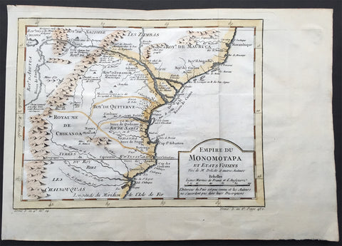
Description:This fine, original copper-plate engraved antique map of Southern Brazil from from Camarin to Cape St Marie by Jacques Nicolas Bellin in 1755 was published in Antoine François Prevosts 15 volumes of Histoire Generale des Voyages written by Prevost & other authors between 1746-1790.The land now called Brazil was claimed for the Portuguese Empire on 22 April 1500, with the arrival of the Portuguese fleet commanded by Pedro Álvares Cabral. The Portuguese encountered indigenous peoples divided into several tribes, most of whom spoke languages of the Tupi–Guarani family, and fought among themselves. Though the first settlement was founded in 1532, colonization effectively began in 1534, when King Dom João III of Portugal divided the territory into the fifteen private and autonomous Captaincy Colonies of Brazil.However, the decentralized and unorganized tendencies of the captaincy colonies proved problematic, and in 1549 the Portuguese king restructured them into the Governorate General of Brazil, a single and centralized Portuguese colony in South America. In the first two centuries of colonization, Indigenous and European groups lived in constant war, establishing opportunistic alliances in order to gain advantages against each other. By the mid-16th century, cane sugar had become Brazil\'s most important exportation product, and slaves purchased in Sub-Saharan Africa, in the slave market of Western Africa (not only those from Portuguese allies of their colonies in Angola and Mozambique), had become its largest import, to cope with plantations of sugarcane, due to increasing international demand for Brazilian sugarBy the end of the 17th century, sugarcane exports began to decline, and the discovery of gold by bandeirantes in the 1690s would become the new backbone of the colony\'s economy, fostering a Brazilian Gold Rush which attracted thousands of new settlers to Brazil from Portugal and all Portuguese colonies around the world. This increased level of immigration in turn caused some conflicts between newcomers and old settlers.Portuguese expeditions known as Bandeiras gradually advanced the Portugal colonial original frontiers in South America to approximately the current Brazilian borders. In this era other European powers tried to colonize parts of Brazil, in incursions that the Portuguese had to fight, notably the French in Rio during the 1560s, in Maranhão during the 1610s, and the Dutch in Bahia and Pernambuco, during the Dutch–Portuguese War, after the end of Iberian Union.The Portuguese colonial administration in Brazil had two objectives that would ensure colonial order and the monopoly of Portugal\'s wealthiest and largest colony: to keep under control and eradicate all forms of slave rebellion and resistance, such as the Quilombo of Palmares, and to repress all movements for autonomy or independence, such as the Minas Conspiracy
General Definitions:Paper thickness and quality: - Heavy and stablePaper color : - off whiteAge of map color: - EarlyColors used: - Green, Yellow,General color appearance: - AuthenticPaper size: - 10in x 7 1/2in (255mm x 190mm)Plate size: - 9 1/2in x 7in (240mm x 180mm)Margins: - Min 1/2in (12mm)
Imperfections:Margins: - NonePlate area: - NoneVerso: - None
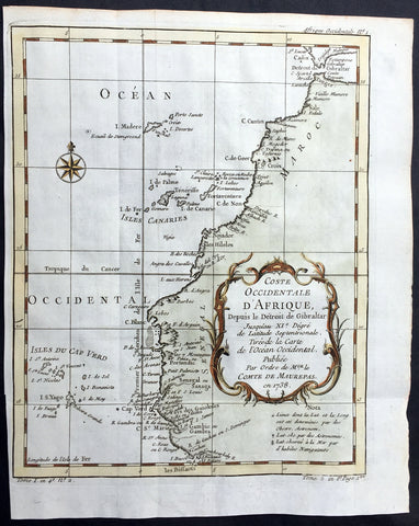
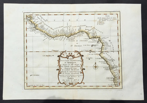
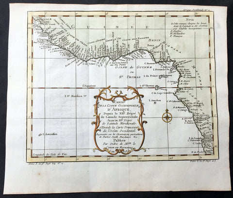
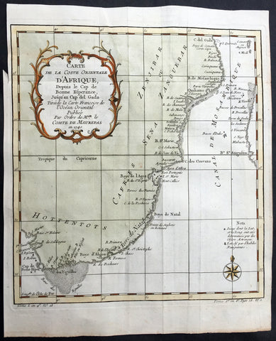
Background: One of Antoine Francois Prevosts monumental undertakings was his history of exploration & discovery in 15 volumes titledHistoire Générale des Voyages written between 1746-1759 and was extended to 20 volumes after his death by various authors.The 20 volumes cover the early explorations & discoveries on 3 continents: Africa (v. 1-5), Asia (v. 5-11), and America (v. 12-15) with material on the finding of the French, English, Dutch, and Portugese.A number of notable cartographers and engravers contributed to the copper plate maps and views to the 20 volumes including Nicolas Bellin, Jan Schley, Chedel, Franc Aveline, Fessard, and many others.The African volumes cover primarily coastal countries of West, Southern, and Eastern Africa, plus the Congo, Madagascar, Arabia and the Persian Gulf areas.The Asian volumes cover China, Korea, Tibet, Japan, Philippines, and countries bordering the Indian Ocean.Volume 11 includes Australia and Antarctica.Volumes 12-15 cover voyages and discoveries in America, including the East Indies, South, Central and North America.Volumes 16-20 include supplement volumes & tables along with continuation of voyages and discoveries in Russia, Northern Europe, America, Asia & Australia.