
Johann Baptist Homann (1663 – 1724)
Profile :
Following the long period of Dutch domination in the field of Cartography, the Homann family became the most important map publishers in Germany in the eighteenth century. The business being founded by J.B. Homann in Nuremberg about the year 1702.
Soon after publishing his first atlas in 1707 he became a member of the Berlin academy of Sciences and in 1715 he was appointed Geographer to the Emperor. After the founder’s death in 1724, the firm was continued under the direction of his son until 1730 and was then bequeathed to his heirs on the condition that it trades under the name of Homann Heirs. The firm remained in being until the next century and had a wide influence on map publishing in Germany. Apart from the atlases the firm published a very large number of individual maps.
The Homman’s produced a Neuer Atlas in 1714, a Grosser Atlas in 1737, and an Atlas Maior with about 300 maps in 1780. They also issued a special Atlas of Germany with full sized plans of principal cities, school atlases and an Atlas of Silesia in 1750 with 20 maps.
Johann Baptist Homann (3)
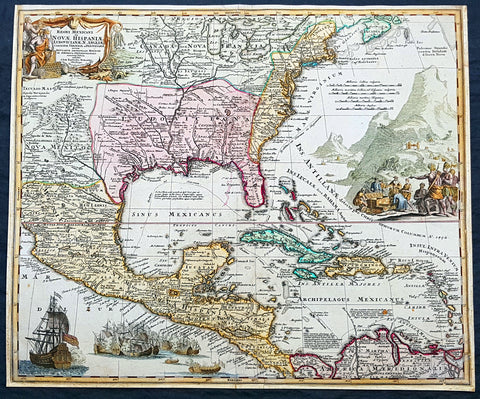
1715 Homann Large Antique Map North America, Great Lakes to New Mexico & Florida
- Title : Regni Mexicani seu Novae Hispaniae, Floridae, Novae Angliae, Carolinae, Virginiae et Pensylvaniae, nec non Insularum, Archipelagi Mexicani in America Septentrionali....Joh Baptista Homanno
- Date : 1715
- Condition: (A) Very Good Condition
- Ref: 93118
- Size: 23in x 19 1/4in (585mm x 485mm)
Description:
This large original beautifully hand coloured antique map of North America, centering on the claims of France, Spain & England in the New World, was published by J B Homann in 1715.
This is a magnificent map, with all the political nuisances of the time, illustrated throughout the map. The tension between the three European super powers is evident, from the waning Spanish, to the aspirational French and the upcoming British. The French borders in Louisiana and Canada push west and south far beyond reality, encroaching into New Mexico, Canada & the British colonial states. Large Spanish warships are seen to overpower both the British & French fleets in one cartouche and in the other the powerless native Americans are seen as their gold is plundered by all.
With the death of Queen Anne in 1714 and the ascension of George I to the British throne, the era of British power in the New World will lead to the inevitable hard fought freedom of a new country, the United States. A great early 18th century map.
General Definitions:
Paper thickness and quality: - Heavy and stable
Paper color : - off white
Age of map color: - Original & later
Colors used: - Yellow, green, blue, pink
General color appearance: - Authentic
Paper size: - 23in x 19 1/4in (585mm x 485mm)
Plate size: - 23in x 19 1/4in (585mm x 485mm)
Margins: - Min 1in (25mm)
Imperfections:
Margins: - Soiling in margins, L,R & B margins cropped to plate mark.
Plate area: - Age toning
Verso: - Earlier backed onto contemporary paper
Background:
Homanns 1715 map of North America from Mexico, Florida, New England, the West Indies, and the Mississippi Valley (Louisiana) was based on the earlier 1703 map of the same region by Claude Delisle, Carte du Mexique et de la Florida des Terres Angloises, who derived his information from the likes of La Salle, Bienville, d Iberville, Le Sueur and other French, British & Spanish explorers.
The map centres on Louisiana and the Mississippi River Valley, with detailed information of Mexico to the Pacific, north to New Mexico and the Great Lakes. East to the Colonial states, French Florida, The West Indies and northern South America.
Louisiana is divided as per the French borders in Delisles map, with large French aspirations extending well into Spanish North America from the Rio Grande to the Appalachian Mountains. France also lays claim to large sways of land in Canada and the whole of the Great Lakes and much of the northern colonial states of the time. One of the earliest maps to accurately portray the mouth of the Mississippi and the Great Lakes region.
An elaborately decorative map with illustrations of Spanish unloading gold while the native Americans look on. To the lower left is shown a large Spanish Galleon, with guns blazing on the smaller French or British fleet, highlighting the still evident power of the Spanish. A very political European view of the new world in the early 18th century.
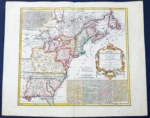
1756 Homann Antique Map Colonial United States North America French Indian War
- Title : America Septentrionalis a domino d Anville in Galiis edita nunc in Anglia coloniis in interiorem Virginiam deductis nec non fluvii Ohio cursu aucta notisq geographicis et historicis illustrata.....1756
- Date : 1756
- Condition: (A+) Fine Condition
- Ref: 93124
- Size: 25 1/2in x 21in (650mm x 535mm)
Description:
This magnificent hand coloured original copper-plate engraved antique 1st edition map of the Colonial United States, at the beginning of the French-Indian war, was engraved in 1756 - dated in cartouche - by the Homann firm, Germany.
Impressive first edition of The Homann map of the English Colonies in North America prior to the start of the French and Indian War. The map stretches just west of the Mississippi River to the east and from James Bay through the Great Lakes to the Gulf of Mexico. Although most of the text is in German, there is also much in English, including numerous place named annotations associated the French and Indian War, such as the locations of Fort Duquesne and Fort Necessity, both taken by the French in 1754. Thus although the cartographer credits D Anville for the basic cartography, it is clear he is drawing from English, not French, sources. Bottom right and upper left are notes offering the history of North America.
General Definitions:
Paper thickness and quality: - Heavy and stable
Paper color : - off white
Age of map color: - Original & later
Colors used: - Yellow, green, blue, pink
General color appearance: - Authentic
Paper size: - 25 1/2in x 21in (650mm x 535mm)
Plate size: - 21in x 18 1/2in (535mm x 485mm)
Margins: - Min 1in (25mm)
Imperfections:
Margins: - Light soiling in margins
Plate area: - None
Verso: - None
Background:
The French and Indian War (1754–63) comprised the North American theatre of the worldwide Seven Years War of 1756–63. It pitted the colonies of British America against those of New France. Both sides were supported by military units from their parent countries, as well as by American Indian allies. At the start of the war, the French North American colonies had a population of roughly 60,000 settlers, compared with 2 million in the British North American colonies. The outnumbered French particularly depended on the Indians. The European nations declared war on one another in 1756 following months of localized conflict, escalating the war from a regional affair into an intercontinental conflict.
The name French and Indian War is used mainly in the United States. It refers to the two enemies of the British colonists, the royal French forces and their various American Indian allies. The British colonists were supported at various times by the Iroquois, Catawba, and Cherokee, and the French colonists were supported by Wabanaki Confederacy members Abenaki and Mikmaq, and Algonquin, Lenape, Ojibwa, Ottawa, Shawnee, and Wyandot.
British and other European historians use the term the Seven Years War, as do English-speaking Canadians. French Canadians call it La guerre de la Conquête (the War of the Conquest) or (rarely) the Fourth Intercolonial War.
Fighting took place primarily along the frontiers between New France and the British colonies, from Virginia in the south to Newfoundland in the north. It began with a dispute over control of the confluence of the Allegheny River and Monongahela River called the Forks of the Ohio, and the site of the French Fort Duquesne in Pittsburgh, Pennsylvania. The dispute erupted into violence in the Battle of Jumonville Glen in May 1754, during which Virginia militiamen under the command of 22-year-old George Washington ambushed a French patrol.
In 1755, six colonial governors in North America met with General Edward Braddock, the newly arrived British Army commander, and planned a four-way attack on the French. None succeeded, and the main effort by Braddock proved a disaster; he lost the Battle of the Monongahela on July 9, 1755 and died a few days later. British operations failed in the frontier areas of Pennsylvania and New York during 1755–57 due to a combination of poor management, internal divisions, effective Canadian scouts, French regular forces, and Indian warrior allies. In 1755, the British captured Fort Beauséjour on the border separating Nova Scotia from Acadia, and they ordered the expulsion of the Acadians (1755–64) soon afterwards. Orders for the deportation were given by William Shirley, Commander-in-Chief, North America, without direction from Great Britain. The Acadians were expelled, both those captured in arms and those who had sworn the loyalty oath to His Britannic Majesty. Indians likewise were driven off the land to make way for settlers from New England.
The British colonial government fell in the region of modern Nova Scotia after several disastrous campaigns in 1757, including a failed expedition against Louisbourg and the Siege of Fort William Henry; this last was followed by Indians torturing and massacring their British victims. William Pitt came to power and significantly increased British military resources in the colonies at a time when France was unwilling to risk large convoys to aid the limited forces that they had in New France, preferring to concentrate their forces against Prussia and its allies in the European theater of the war. Between 1758 and 1760, the British military launched a campaign to capture the Colony of Canada (part of New France). They succeeded in capturing territory in surrounding colonies and ultimately the city of Quebec (1759). The British later lost the Battle of Sainte-Foy west of Quebec (1760), but the French ceded Canada in accordance with the Treaty of Paris (1763).
The outcome was one of the most significant developments in a century of Anglo-French conflict. France ceded to Great Britain its territory east of the Mississippi. It ceded French Louisiana west of the Mississippi River (including New Orleans) to its ally Spain in compensation for Spains loss to Britain of Florida. (Spain had ceded Florida to Britain in exchange for the return of Havana, Cuba.) Frances colonial presence north of the Caribbean was reduced to the islands of Saint Pierre and Miquelon, confirming Great Britains position as the dominant colonial power in eastern North America.
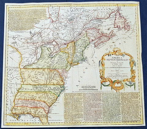
1777 Homann Antique Map Colonial United States, North America Revolutionary War
- Title : America Septentrionalis a domino d Anville in Galiis edita nunc in Anglia coloniis in interiorem Virginiam deductis nec non fluvii Ohio cursu aucta notisq geographicis et historicis illustrata.....1777
- Date : 1777
- Condition: (A) Very Good Condition
- Ref: 93123
- Size: 20 1/2in x 18 1/2in (510mm x 470mm)
Description:
This magnificent hand coloured original copper-plate engraved antique map of the Colonial United States, at the beginning of the American Revolutionary War, was engraved in 1777 - dated in cartouche - by the Homann firm, Germany.
Detailed map of the British Colonies in North America, published at the beginning of the American Revolution. The map is based on the cartography of J.B.B. D Anville, although the political boundaries are British leaning, based upon Thomas Jefferys map of the British Colonies published in 1755 for the political detail. The map depicts the various British colonial claims, including: Bounds of Hudson Bay by the Treaty of Utrecht, North Limits of New England by Charter of 1620 (to the west of Lake Superior) Boundary between Virginia & New England, Boundary between Carolina & Virginia, Boundary of South Carolina by Charter of 1663. Also shown are notes many British Forts, a well as Walkers Settlement on the Cumberland or Shannowens River. Many Indian Tribes are also noted. To the bottom right and top left are annotations of the English occupation of North America dating back to Cabot in 1497, with a brief historical account of each of the British Colonies. Also included is a similar account of the French history in North America.
General Definitions:
Paper thickness and quality: - Heavy and stable
Paper color : - off white
Age of map color: - Original & later
Colors used: - Yellow, green, blue, pink
General color appearance: - Authentic
Paper size: - 20 1/2in x 18 1/2in (510mm x 470mm)
Plate size: - 20 1/2in x 18 1/2in (510mm x 470mm)
Margins: - Min 1/2in (12mm)
Imperfections:
Margins: - Margins cropped to plate-mark
Plate area: - Age toned
Verso: - Age toned
Background:
The American Revolutionary War (1775–1783), also known as the American War of Independence, was an 18th-century war between Great Britain and its Thirteen Colonies (allied with France) which declared independence as the United States of America.
After 1765, growing constitutional and political differences strained the relationship between Great Britain and its colonies. Patriot protests against taxation without representation followed the Stamp Act and escalated into boycotts, which culminated in 1773 with the Sons of Liberty destroying a shipment of tea in Boston Harbor. Britain responded by closing Boston Harbor and passing a series of punitive measures against Massachusetts Bay Colony. Massachusetts colonists responded with the Suffolk Resolves, and they established a shadow government which wrested control of the countryside from the Crown. Twelve colonies formed a Continental Congress (with the exception of Georgia) to coordinate their resistance, establishing committees and conventions that effectively seized power.
British attempts to disarm the Massachusetts militia in Concord led to open combat and a British defeat on April 19, 1775. Militia forces then besieged Boston, forcing a British evacuation in March 1776, and Congress appointed George Washington to command the Continental Army. Concurrently, the Americans failed decisively in an attempt to invade Quebec and raise insurrection against the British. On July 2, 1776, the Second Continental Congress voted for independence, issuing its declaration on July 4. Sir William Howe launched a British counter-offensive, capturing New York City and leaving American morale at a low ebb. However, victories at Trenton and Princeton restored American confidence. In 1777, the British launched an invasion from Quebec under John Burgoyne, intending to isolate the New England Colonies. Instead of assisting this effort, Howe took his army on a separate campaign against Philadelphia, and Burgoyne was decisively defeated at Saratoga in October 1777.
Burgoynes defeat had drastic consequences. France formally allied with the Americans and entered the war in 1778, and Spain joined the war the following year as an ally of France but not as an ally of the United States. In 1780, the Kingdom of Mysore attacked the British in India, and tensions between Great Britain and the Netherlands erupted into open war. In North America, the British mounted a Southern strategy led by Charles Cornwallis which hinged upon a Loyalist uprising, but too few came forward. Cornwallis suffered reversals at Kings Mountain and Cowpens. He retreated to Yorktown, Virginia, intending an evacuation, but a decisive French naval victory deprived him of an escape. A Franco-American army led by the Comte de Rochambeau and Washington then besieged Cornwallis army and, with no sign of relief, he surrendered in October 1781.
Whigs in Britain had long opposed the pro-war Tories in Parliament, and the surrender gave them the upper hand. In early 1782, Parliament voted to end all offensive operations in America, but the war continued overseas. Britain remained under siege in Gibraltar but scored a major victory over the French navy. On September 3, 1783, the belligerent parties signed the Treaty of Paris in which Great Britain agreed to recognize the sovereignty of the United States and formally end the war. French involvement had proven decisive, but France made few gains and incurred crippling debts. Spain made some territorial gains but failed in its primary aim of recovering Gibraltar. The Dutch were defeated on all counts and were compelled to cede territory to Great Britain. In India, the war against Mysore and its allies concluded in 1784 without any territorial changes.