Welcome to Classical Images!
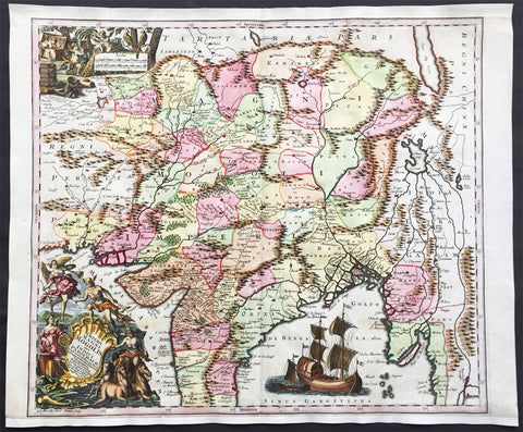
Description:This original large beautifully hand coloured copper plate engraved antique map of the ancient region of Silesia, now located in Western Poland - with an inset plan of the city of Wroclaw (Breslau) - was published by GM Seutter in 1730 (Ref: Tooley; M&B)
General Definitions:Paper thickness and quality: - Heavy and stablePaper color : - off whiteAge of map color: - OriginalColors used: - Blue, pink, red, green, yellowGeneral color appearance: - AuthenticPaper size: - 24 1/2in x 21in (615mm x 525mm)Plate size: - 23in x 20in (590mm x 505mm)Margins: - Min 1in (25mm)
Imperfections:Margins: - NonePlate area: - Light discolouration to top centeroldVerso: - None
Background:Silesia is a historical region of Central Europe mostly in Poland, with small parts in the Czech Republic and Germany. Its area is approximately 40,000 km2, and the population is estimated at around 8,000,000 inhabitants. Silesia is split into two main sub-regions of Lower Silesia in the west and Upper Silesia in the east. Silesia has a diverse culture, including architecture, costumes, cuisine, traditions, and the Silesian language.Silesia is along the Oder River, with the Sudeten Mountains extending across the southern border. The region possesses many historical landmarks and UNESCO World Heritage Sites. It is also rich in mineral and natural resources, and includes several important industrial areas. Silesias largest city and historical capital is Wrocław. The biggest metropolitan area is the Upper Silesian metropolitan area, the centre of which is Katowice. Parts of the Czech city of Ostrava and the German city of Görlitz fall within the borders of Silesia.Silesias borders and national affiliation have changed over time, both when it was a hereditary possession of noble houses and after the rise of modern nation-states. The varied history with changing aristocratic possessions resulted in an abundance of castles, especially in the Jelenia Góra valley. The first known states to hold power in Silesia were probably those of Greater Moravia at the end of the 9th century and Bohemia early in the 10th century. In the 10th century, Silesia was incorporated into the early Polish state, and after its division in the 12th century became a Piast duchy. In the 14th century, it became a constituent part of the Bohemian Crown Lands under the Holy Roman Empire, which passed to the Austrian Habsburg Monarchy in 1526. As a result of the Silesian Wars, the region was annexed by Prussia in 1742.After World War I, the easternmost part of Upper Silesia was granted to Poland by the Entente Powers after insurrections by Poles and the Upper Silesian plebiscite. The remaining former Austrian parts of Silesia were partitioned to Czechoslovakia, forming part of Czechoslovakias Sudetenland region, and are today part of the Czech Republic. In 1945, after World War II, the bulk of Silesia was transferred to Polish jurisdiction by the Potsdam Agreement between the victorious Allies and became part of Poland, whose Communist government expelled the majority of Silesias previous population. The small Lusatian strip west of the Oder–Neisse line, which had belonged to Silesia since 1815, remained in Germany.