Exploration (1)
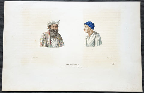
1824 Louis Freycinet Antique Print Chief of Waigeo Is & Man of Gebe Is Indonesia
- Title : Iles Des Papous - 1. Abas, frere du Kimalaha de l ile Guebe 2. Aas, chef du village de Kabarei
- Ref #: 31740
- Size: 19in x 12 1/2in (485mm x 320mm)
- Date : 1822
- Condition: (A) Very Good Condition
Description:
This magnificent large hand coloured original copper-plate engraved antique print of 1. Abas man of the Maluku Indonesian Island of Gebe & 2. Aas The Chief of the village of Kabarei on the Indonesian Island of Waigeo (Plate no. 39) by Alphonse Pellion, artist aboard the ship L Uranie (visited by Louis Freycinet in late 1818) was engraved by Jean-F Choubard and published in the 1824 1st edition of Louis De Freycinets Atlas Voyage autour du monde fait par ordre du Roi sur les corvettes de S. M. l\'Uranie et la Physicienne, pendant les années 1817, 1818, 1819 et 1820
These magnificent large hand coloured 1st edition engravings are extremely scarce and a must for any collection.
Alphonse Pellion, artist and naval draughtsman, was a midshipman aboard l Uranie on Louis de Freycinets three-year scientific and ethnographic expedition around the world in 1817-1820. Pellion assisted the official artists, Arago and Taunay.
Waigeo is an island in West Papua province of eastern Indonesia. The island is also known as Amberi, or Waigiu. It is the largest of the four main islands in the Raja Ampat Islands archipelago, between Halmahera and about 65 kilometres to the north-west coast of New Guinea. The Dampier Strait (a.k.a. Augustas Strait) separates it from Batanta, and the Bougainville Strait from the Kawe Islands to its north-west. The inner sea that nearly cleaves the island in two is the Majoli Gulf. Jorge de Menezes, a Portuguese explorer, landed on Waigeo Island in 1526-27.
Gebe is an island of Maluku Islands, Indonesia.
General Definitions:
Paper thickness and quality: - Heavy and stable
Paper color : - off white
Age of map color: - Original
Colors used: - Yellow, green, blue, pink
General color appearance: - Authentic
Paper size: - 19in x 12 1/2in (485mm x 320mm)
Plate size: - 13in x 9 ½in (330mm x 240mm)
Margins: - Min 2in (50mm)
Imperfections:
Margins: - Light offsetting
Plate area: - Light offsetting
Verso: - Light offsetting
Background:
After the Restoration the French government gave Freycinet, then a captain, command of another expedition to circumnavigate the globe and conduct research into the shape of the earth, meteorology and terrestrial magnetism. He sailed from Toulon on 17 September 1817 in L Uranie with his wife Rose who secreted herself aboard, and who wrote a separate account of the voyage. After refreshing at the Cape of Good Hope and Mauritius he landed at Shark Bay, Western Australia on 12 September 1818 where he set up an observatory, thoroughly surveyed the inlets and the coastal districts and removed the plate left by Willem de Vlamingh, which he had found and re-erected in 1801. He then sailed north to Timor. His accounts and description of the landscape and life and customs of that and other islands in the East Indies captivated the attention of people in Europe much more than his Australian reports, and a widespread interest developed in the expedition. Leaving Timor on 27 November he sailed via the Moluccas, the Carolines, the Marianas, and the Sandwich Islands and reached Port Jackson on 19 November 1819, the scientists on board adding constantly to their store of information on hydrography, botany, cartography and anthropology. After spending Christmas ashore, they sailed on 26 December and, falling in with the westerlies, set a course for Cape Horn.
On 13 February 1820 L Uranie was wrecked on the Falkland Islands; the scientific records and notes were saved before the vessel foundered, but 2500 of the 4175 plant specimens were lost. Freycinet returned to France in November 1820 and died on 18 August 1842.
There is no evidence in the expedition\'s records or French governmental archives to suggest that there were political objectives in this circumnavigation but, though its purpose was to engage in scientific discovery, this first major voyage undertaken by the restored Bourbons did show the French flag in distant seas and foreshadowed a series of other expeditions which were not wholly scientific.

