City Plans (1)
1757 J N Bellin Antique Map Early Plan The City of New Orleans Louisiana America
- Title : Plan de la Nouvelle Orleans
- Ref #: 35628
- Size: 13 1/2in x 10in (345mm x 255mm)
- Date : 1757
- Condition: (A+) Fine Condition
Description:
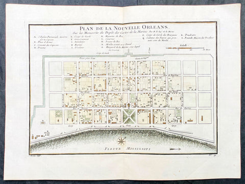
This original hand coloured copper plate engraved antique map, a very early plan of the city of New Orleans, by Jacques Nicholas Bellin was published in the 1757 French edition of Antoine-François Prevosts 20 volume L Histoire Generale des Voyages published by Pierre de Hondt in the Hague between 1747 & 1785.
This detailed & beautifully executed 18th-century map of New Orleans was first printed in Xavier Charlevoixs Histoire de la Nouvelle France in 1744. The map was subsequently reissued with Provost's Histoire des Voyages in 1750 and in later editions of Charlevoix & Bellins 1764 Petit Atlas Maritime.
General Definitions:
Paper thickness and quality: - Heavy and stable
Paper color : - off white
Age of map color: - Early
Colors used: - Yellow, green, blue, pink
General color appearance: - Authentic
Paper size: - 13 1/2in x 10in (345mm x 255mm)
Plate size: - 11 1/2in x 8in (295mm x 204mm)
Margins: - Min 1/2in (12mm)
Imperfections:
Margins: - None
Plate area: - None
Verso: - None
Background:
Plan de la Nouvelle Orleans was based on the original manuscript town-plan of the city drafted by Le Blond de la Tour in 1722. The cartographer, Jacques-Nicolas Bellin (1703-72), was one of the most significant cartographers of his time. His skill was such that he was eventually appointed Official Hydrographer to the French King. Using the streets of Iberville, Dauphine, and Barracks (current names) along with the Mississippi River as borders, this map almost entirely captures the modern-day French Quarter. Thus, the map encompasses well-known streets such as Bourbon, Chartres, and Royal, with 18 marked locations such as the religious buildings of the Capuchins and Ursulines, the prison, the munitions store, the huts for the African-Americans (slaves) who worked at the mill, and more. Even Jackson Square—a military plaza, a public execution site, a Civil War armory, and today a public gathering spot—is shown on the map as Place d'Armes. New Orleans is depicted (and remains) a highly symmetrical city focused toward the Mississippi. Later state, likely circa 1764; the first state bears a date, has the title in a different position, and includes the note in the lower right corner that the map was engraved by Dheulland.