Welcome to Classical Images!
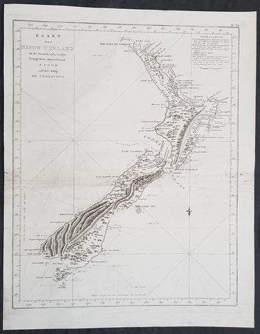
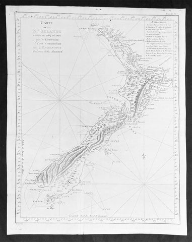
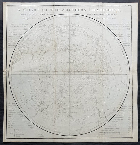
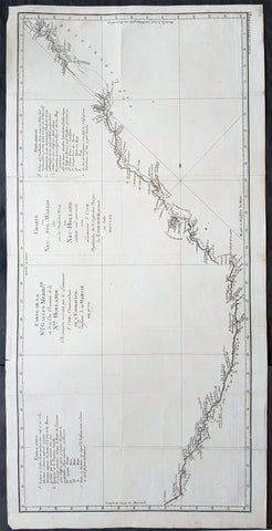
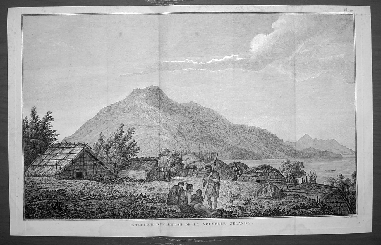
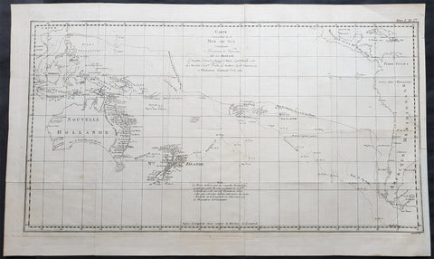
Description:This fine original copper-plate engraved antique print of a Maori Marae on Motuara Island in Queen Charlotte Sound, New Zealand, visited by Captain Cook in HMS Resolution & Discovery in February 1777, during his 3rd & last Voyage of Discovery, was engraved by Robert Benard - after John Webber - and was published in the 1785 French edition of Capt. James Cook & Capt. James King publication A Voyage to the Pacific Ocean. Undertaken, by the Command of his Majesty, for making Discoveries in the Northern Hemisphere. To determine The Position and Extent of the West Side of North America; its Distance from Asia; and the Practicability of a Northen Passage to Europe. Performed under the direction of Captains Cook, Clerke, and Gore, In His Majesty\\\'s Ships the Resolution and Discovery. In the Years 1776, 1777, 1778, 1779, and 1780. In Three Volumes. Vol. I and II written by James Cook, F.R.S. Vol. III by Captain James King, LL.D. and F.R.S. Paris, 1785.John Webber made countless watercolours, pen and ink sketches and drawings on James Cooks third voyage to the Pacific (1776-80). These were the basis for the finished watercolours which engravers used in producing the 61 illustrations for the official published account of his third voyage.The Inside of a Hippah is the only New Zealand plate in the publication. This reflects the fact that only a short time was spent in the country on the third voyage, and also the cautionary approach taken during their stay here. The ships moored in Ship Cove, Queen Charlotte Sound from 12-25 February 1777. On Cooks previous voyage a boat load of people had been attacked and killed there. Consequently, shore parties were only made in large armed groups and Webber would have been restricted in his ability to record the area and its inhabitants.Depicted is a scene from Queen Charlotte Sound, probably Motuara Island with the waters of the Sound to the right. Cook recounted visiting the Island on 15 February 1777, noting that it was currently uninhabited, although showed signs of recent occupation with parts rebuilt since their last visit. Webber, however, populates his view, placing four figures in conversation in the foreground, with another group beyond to the right. Joppien and Smith suggest that he does this so as to strike a humane and deliberately pensive note, one which would appeal to current European sentiment They add that European artists at this time still included \'staffage\' to provide interest in landscape views and further it provided Webber with the opportunity to record the dress and weaponry of Māori. The inclusion of Māori housing reveals Cook\'s ethnographic interest. The Royal Society had recommended that he pay particular attention to the housing of the natives he encountered as it was indicative of the type of society, and he therefore made detailed notes about habitation practices on his journeys.
General Definitions:Paper thickness and quality: - Heavy and stablePaper color : - off whiteAge of map color: -Colors used: -General color appearance: -Paper size: - 15 3/4in x 9 3/4in (400mm x 250mm)Plate size: - 14 3/4in x 9 1/2in (375mm x 245mm)Margins: - Min 1/2in (12mm)
Imperfections:Margins: - NonePlate area: - Folds as issuedVerso: - None
Background: In New Zeland Māori society, the marae is a place where the culture can be celebrated, where the Māori language can be spoken, where intertribal obligations can be met, where customs can be explored and debated, where family occasions such as birthdays can be held, and where important ceremonies, such as welcoming visitors or farewelling the dead (tangihanga), can be performed. Like the related institutions of old Polynesia, the marae is a wāhi tapu, a \'sacred place\' which carries great cultural meaning.In Māori usage, the marae atea (often shortened to marae) is the open space in front of the wharenui or meeting house (literally large building). However, the term marae is generally used to refer to the whole complex, including the buildings and the open space. This area is used for pōwhiri – welcome ceremonies featuring oratory. Some marae do not allow women to perform oratory there. The meeting house is the locale for important meetings, sleepovers, and craft and other cultural activities. The wharekai (dining hall) is used primarily for communal meals, but other activities may be carried out there. Many of the words associated with marae in tropical Polynesia are retained in the Māori context. For example, the word paepae refers to the bench where the speakers sit; this means it retains its sacred and ceremonial associations. Marae occur in various sizes, with some wharenui being a bit bigger than a double garage and some being larger than a town hall.New Zealand, Aotearoa is an island country in the southwestern Pacific Ocean. The country geographically comprises two main landmasses—the North Island (or Te Ika-a-Māui), and the South Island (or Te Waipounamu)—and around 600 smaller islands. New Zealand is situated some 1,500 kilometres east of Australia across the Tasman Sea and roughly 1,000 kilometres south of the Pacific island areas of New Caledonia, Fiji, and Tonga.The first Europeans known to have reached New Zealand were Dutch explorer Abel Tasman and his crew in 1642. In a hostile encounter, four crew members were killed and at least one Māori was hit by canister shot. Europeans did not revisit New Zealand until 1769 when British explorer James Cook mapped almost the entire coastline. Cook revisited New Zealand on voyages 2&3, in 1773 & 1777.Captain James King FRS 1750 – 1784 was an officer of the Royal Navy. He served under James Cook on his last voyage around the world, specialising in taking important astronomical readings using a sextant. After Cook died he helped lead the ships on the remainder of their course, also completing Cooks account of the voyage. He continued his career in the Navy, reaching the rank of post-captain, commanding several ships and serving in the American War of Independence.King joined HMS Resolution as second lieutenant, sharing the duties of astronomer with Cook, taking astronomical observations on board by sextant and with Larcum Kendals timekeeper K1, to establish the Resolutions position at sea and on shore by sextant or by astronomical quadrant to establish the geographical position of salient points during the course of Cooks surveys. Thus Kings geographical positions were an important contribution to the accuracy of the various surveys carried out during the voyage and his use of the early chronometers helped prove their use at sea for calculation of Longitude. .Following the death of Cook, King remained in the Resolution but on the death of Charles Clerke, Cooks successor, King was appointed to command HMS Discovery, the Resolutions consort, remaining in her for the rest of the voyage. After his return to England King was very much involved in the publication of the official account of Cooks third voyage, writing the third volume at Woodstock, near Oxford, where his brother Thomas was rector of St Mary Magdalene. But shortly after his return King was promoted Post-captain and appointed commander of HMS Crocodile in the English Channel.John Webber RA 1751 – 1793 was an English artist who accompanied Captain Cook on his third Pacific expedition. He is best known for his images of Australasia, Hawaii and Alaska.Webber was born in London, educated in Bern and studied painting at Paris.His father was Abraham Wäber, a Swiss sculptor who had moved to London, and changed his name to Webber before marrying a Mrs Mary Quant in 1744.Webber served as official artist on James Cooks third voyage of discovery around the Pacific (1776–80) aboard HMS Resolution. At Adventure Bay in January 1777 he did drawings of A Man of Van Diemens Land and A Woman of Van Diemens Land. He also did many drawings of scenes in New Zealand and the South Sea islands. On this voyage, during which Cook lost his life in a fight in Hawaii, Webber became the first European artist to make contact with Hawaii, then called the Sandwich Islands. He made numerous watercolor landscapes of the islands of Kauai and Hawaii, and also portrayed many of the Hawaiian people.In April 1778, Captain Cooks ships Resolution and Discovery anchored at Ship Cove, now known as Nootka Sound, Vancouver Island, Canada to refit. The crew took observations and recorded encounters with the local people. Webber made watercolour landscapes including Resolution and Discovery in Ship Cove, 1778. His drawings and paintings were engraved for British Admiraltys account of the expedition, which was published in 1784.Back in England in 1780 Webber exhibited around 50 works at Royal Academy exhibitions between 1784 and 1792, and was elected an associate of the Royal Academy in 1785 and R.A. in 1791. Most of his work were landscapes. Sometimes figures were included as in A Party from H.M.S. Resolution shooting sea horses, which was shown at the academy in 1784, and his The Death of Captain Cook became well known through an engraving of it. Another version of this picture is in the William Dixson gallery at SydneyRobert Bénard 1734 – 1777 was an 18th-century French engraver.Specialized in the technique of engraving, Robert Ménard is mainly famous for having supplied a significant amount of plates (at least 1,800) to the Encyclopédie by Diderot & d Alembert from 1751.Later, publisher Charles-Joseph Panckoucke reused many of his productions to illustrate the works of his catalog.