Welcome to Classical Images!
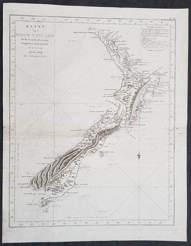
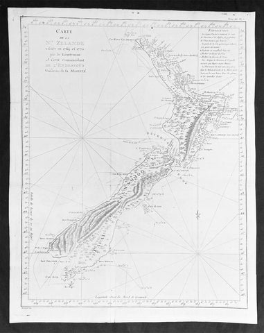
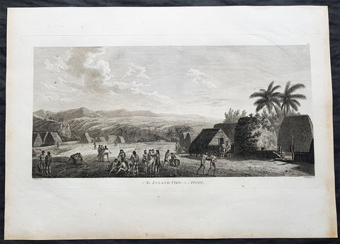
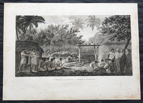
Description:This fine original copper-plate engraved antique map, four maps on the one sheet; 1. Matavia Bay, Tahiti (Otaheite) - Windward Islands2. Ohamaneno (Vaiaau) Harbour Raiatea (Ulietea) - Leeward Islands3. Owharre (Bourayne Bay) Harbour in Huaheine - Leeward Islands4. Oopoa (Opoa) Harbour, Raiatea (Ulietea) - Leeward Islandsall located in French Polynesia, South Pacific were complied by Capt James Cook during his first voyage of discovery in 1769, was published in the 1774 French edition of John Hawkesworths An Account of the Voyages Undertaken by the Order of His Present Majesty for Making Discoveries in the Southern Hemisphere and Successively Performed by Commodore Byron, Captain Wallis, Captain Carteret, and Captain Cook, in the Dolphin, the Swallow, and the Endeavor, Drawn Up from the Journals Which Were Kept by the Several Commanders, and from the Papers of Joseph Banks, Esq. Paris 1774
General Definitions:Paper thickness and quality: - Heavy and stablePaper color : - off whiteAge of map color: - Colors used: - General color appearance: - Paper size: - 14 1/2in x 10in (370mm x 255mm)Plate size: - 14 1/2in x 10in (370mm x 255mm)Margins: - Min 1/2in (12mm)
Imperfections:Margins: - NonePlate area: - Light creasingVerso: - None
Background: Matavai Bay is located on the north coast of Tahiti, the largest island in the Windward group of French Polynesia.The first European known to have visited Tahiti was Lieutenant Samuel Wallis, in Dolphin, who landed on 17 June 1767 in Matavai Bay.Captain James Cook anchored in the bay on 13 April 1769, on a sandy spit on the northeast end of Matavai Bay - named Point Venus by Cook.Raiatea, is the second largest of the Society Islands, after Tahiti, in French Polynesia. The island is widely regarded as the centre of the eastern islands in ancient Polynesia and it is likely that the organised migrations to Hawaii, Aotearoa and other parts of East Polynesia started at Raiātea.Captain Cook visited Raiatea in 1769 and again in 1773-1774.Huahine is an island located among the Society Islands, in French Polynesia, an overseas territory of France in the Pacific Ocean. It is part of the Leeward Islands group (Iles sous le Vent).Captain Cook arrived Fare Harbour on 16 July 1769, with Tupaia navigating the HMS Endeavour. They met with leading chief Ori (Mato). Cook returned on 3 Sept. 1773 and met with Oris son Teri itaria, the new ari i rahi of the island.John Hawkesworth 1715 – 1773An English writer and journalist, Hawkesworth was commissioned by the British Admiralty to edit for publication the narratives of its officers’ circumnavigations. He was given full access to the journals of the commanders and the freedom to adapt and re-tell them in the first person. Cook was already on his way back from his second Pacific voyage, temporarily docked at Cape Town (South Africa), when he first saw the published volumes: he was mortified and furious to find that Hawkesworth claimed in the introduction that Cook had seen and blessed (with slight corrections) the resulting manuscript. (In his defense, Hawkesworth also had been a victim of misunderstanding.) Cook had trouble recognizing himself. Moreover, the work was full of errors and commentary introduced by Hawkesworth and, in Cook’s view, too full of Banks, who had promoted himself and the publication. Still, the work was popular; the first edition sold out in several months.