
Jacques Nicholas Bellin (1703 - 1772)
Profile :
A French hydrographer, geographer, and member of the French intellectual group called the philosophes.
Bellin was born in Paris. He was hydrographer of France's hydrographic office, member of the Académie de Marine and of the Royal Society of London. Over a 50-year career, he produced a large number of maps of particular interest to the Ministère de la Marine. His maps of Canada and of French territories in North America (New France, Acadia, Louisiana) are particularly valuable. He died at Versailles.
In 1721, at age 18, he was appointed hydrographer (chief cartographer) to the French Navy. In August 1741, he became the first Ingénieur de la Marine of the Depot des cartes et plans de la Marine (the French Hydrographical Office) and was named Official Hydrographer of the French King.
During his reign the Depot came out with prodigious amount of charts and maps among which was a large folio format sea-charts of France, the Neptune Francois. He also produced a number of sea-atlases of the world, e.g., the Atlas Maritime and the Hydrographie Francaise. These gained fame, distinction and respect all over Europe and were republished throughout the 18th and even in the succeeding century.
Bellin also came out with smaller format maps such as the 1764 Petit Atlas Maritime (5 vols.) containing 580 finely detailed charts.
Bellin set a very high standard of workmanship and accuracy thus gaining for France a leading role in European cartography and geography. Many of his maps were copied by other mapmakers of Europe
He was one of the Encyclopédistes, a group of 18th century intellectuals in France who compiled the 35-volume Encyclopédie which was edited by Denis Diderot and Jean le Rond d'Alembert. Bellin contributed 994 articles.
The Encyclopédistes, were part of the group called philosophes among whose members were the great minds of the Age of Enlightenment, e.g., Montesquieu, Voltaire, Rousseau, Baron d'Holbach.
Bellin contributed a number of maps to 15-vol. Histoire Generale des Voyages of Antoine François Prévost or simply known l'Abbe Prevost. One of these maps led to a geographical blunder whose impact reverberates to this day. This was the map of the Philippines which Bellin copied from a world-famous chart produced in 1734 by the Spanish missionary to the Philippines, Fr. Pedro Murillo Velarde.
Unlike many other European mapmakers of the time who outright appropriated Murillo's map, Bellin had the intellectual integrity to fully credit Murillo as his source, an open acknowledgement shown in the title cartouche of Bellin's map which came out the same year as the original work by Murillo.
Shown in Bellin's map was an island named "Limasava", a word invented in 1667 by Spanish friar, Fr. Francisco Combés, S.J., to refer to the way station of the Armada de Molucca under the command of the Portuguese captain-general Fernao de Magalhaes during its navigation in Philippine waters. Combés, who had not read a single eyewitness account of the Magellan expedition relied on two sources, the hopelessly garbled Italian translation of the Antonio Pigafetta account by Giovanni Battista Ramusio and the secondhand account by Antonio de Herrera y Tordesillas. Ramusio wrote the fleet anchored in March–April 1521 in Butuan in Mindanao, and from there sailed for Cebu with a brief stopover at "Messana". In the authentic Pigafetta account, the port was an isle named Mazzaua while the stopover isle was named Gatighan. Antonio de Herrera y Tordesillas gave a faithful narration of the Mazzaua anchorage.
Combés disregarded de Herrera's version and adopted Ramusio's. He wrote that Magellan's fleet had anchored at Butuan and from their sailed for Cebu making a stop at a way station he named Limasaua.
Five years earlier than Combés, Fr. Francisco Colín wrote the Armada moored at Butuan from March–April 1521 where Magellan and his men together with the natives celebrated an Easter Sunday mass on 31 March 1521. From Butuan the fleet sailed for Cebu making a brief stop at a way station he called "Dimasaua", an invented word meaning "this is not the Mazagua of Antonio de Herrera where supposedly an Easter Sunday mass was held which I already said happened in Butuan."
This episode was projected in the 1734 map made by Murillo who used Combés name, "Limassava" not "Dimasaua" which map Bellin copied
In 1789, Augustinian Carlo Amoretti, Italian Encyclopedist and librarian of Biblioteca Ambrosiana in Milan, discovered the authentic Italian manuscript of Antonio Pigafetta among the scattered holdings of the library. Here it came out that the port of March–April 1521 was not Butuan but Mazaua. Amoretti, who himself had not read any of five eyewitness reports of the incident including two French versions of Pigafetta's account, asserted in a footnote that Mazaua was probably the isle named Limasava in Bellin's map, thus interchanging the real port of Mazaua with the way station Gatighan.
Largely with the appearance of the eyewitness account of Ginés de Mafra, the only seaman in Magellan's fleet to return to Mazaua, whose testimony reveals a concrete, measurable description of Mazaua, the skein starting from the garbled version of Pigafetta by Ramusio to the mishandling by Combés to Bellin and finally to Amoretti has been unraveled: Pigafetta's Gatighan is Bellin's Limasava.
Published Works:
- Hydrographie française (1753)
- Carte de l'Amérique septentrionale (Map of Northern America) (1755)
- Le petit Atlas François. Recueil de Cartes et Plans des quatre parties du Monde (1758)
- Petit Atlas Maritime (1764)
- Nouvelle méthode pour apprendre la géographie (1769)
Jacques Nicholas Bellin (1)
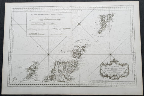
1757 Bellin Large Antique Map of Scotland, Orkneys, Shetlands, Lewis & Harris
- Title : Carte Reduite des Isles Britanniques Quatrieme Feuille Partie Septentrionale de l Ecosse. 1757
- Size: 37 1/2in x 25 1/2in (950mm x 650mm)
- Condition: (A+) Fine Condition
- Date : 1757
- Ref #: 35501
Description:
This very large finely engraved original copper-plate engraved antique map, Sea Chart, of northern Scotland, Orkney & Shetland Islands, Lewis & Harris - along with relief inset of Orkneys - by Jacques Nicolas Bellin in 1757 - dated in the title cartouche.
General Definitions:
Paper thickness and quality: - Heavy and stable
Paper color : - off white
Age of map color: -
Colors used: -
General color appearance: -
Paper size: - 37 1/2in x 25 1/2in (950mm x 650mm)
Plate size: - 35 1/2in x 24in (900mm x 580mm)
Margins: - Min 1in (25mm)
Imperfections:
Margins: - None
Plate area: - None
Verso: - None
Background:
In the 14th century, Orkney and Shetland remained a Norwegian possession, but Scottish influence was growing. Jon Haraldsson, who was murdered in Thurso in 1231, was the last of an unbroken line of Norse jarls, and thereafter the earls were Scots noblemen of the houses of Angus and St Clair. On the death of Haakon VI in 1380, Norway formed a political union with Denmark, after which the interest of the royal house in the islands declined. In 1469, Shetland was pledged by Christian I, in his capacity as King of Norway, as security against the payment of the dowry of his daughter Margaret, betrothed to James III of Scotland. As the money was never paid, the connection with the Crown of Scotland became permanent. In 1470, William Sinclair, 1st Earl of Caithness ceded his title to James III, and the following year the Northern Isles were directly annexed to the Crown of Scotland, an action confirmed by the Parliament of Scotland in 1472. Nonetheless, Shetlands connection with Norway has proved to be enduring.
From the early 15th century on the Shetlanders sold their goods through the Hanseatic League of German merchantmen. The Hansa would buy shiploads of salted fish, wool and butter, and import salt, cloth, beer and other goods. The late 16th century and early 17th century were dominated by the influence of the despotic Robert Stewart, Earl of Orkney, who was granted the islands by his half-sister Mary Queen of Scots, and his son Patrick. The latter commenced the building of Scalloway Castle, but after his imprisonment in 1609 the Crown annexed Orkney and Shetland again until 1643 when Charles I granted them to William Douglas, 7th Earl of Morton. These rights were held on and off by the Mortons until 1766, when they were sold by James Douglas, 14th Earl of Morton to Laurence Dundas.
The trade with the North German towns lasted until the 1707 Act of Union, when high salt duties prevented the German merchants from trading with Shetland. Shetland then went into an economic depression, as the local traders were not as skilled in trading salted fish. However, some local merchant-lairds took up where the German merchants had left off, and fitted out their own ships to export fish from Shetland to the Continent. For the independent farmers of Shetland this had negative consequences, as they now had to fish for these merchant-lairds.
Smallpox afflicted the islands in the 17th and 18th centuries (as it did all of Europe), but as vaccines became available after 1800, health improved. The island was very badly hit by the potato famine of 1846 and the government introduced a Relief Plan for the island under the command of Captain Robert Craigie of the Royal Navy who stayed in Lerwick to oversee the project 1847-1852. During this period Craigie also did much to improve and increase roads on the island.
Population increased to a maximum of 31,670 in 1861. However, British rule came at price for many ordinary people as well as traders. The Shetlanders nautical skills were sought by the Royal Navy. Some 3,000 served during the Napoleonic wars from 1800 to 1815 and press gangs were rife. During this period 120 men were taken from Fetlar alone, and only 20 of them returned home. By the late 19th century 90% of all Shetland was owned by just 32 people, and between 1861 and 1881 more than 8,000 Shetlanders emigrated. With the passing of the Crofters Act in 1886 the Liberal prime minister William Gladstone emancipated crofters from the rule of the landlords. The Act enabled those who had effectively been landowners serfs to become owner-occupiers of their own small farms. By this time fishermen from Holland, who had traditionally gathered each year off the coast of Shetland to fish for herring, triggered an industry in the islands that boomed from around 1880 until the 1920s when stocks of the fish began to dwindle. The production peaked in 1905 at more than a million barrels, of which 708,000 were exported