Welcome to Classical Images!
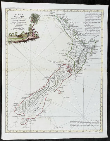
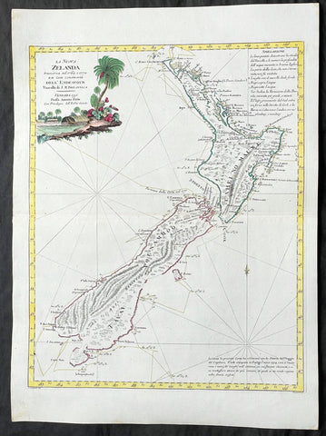
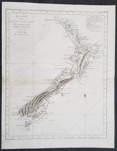
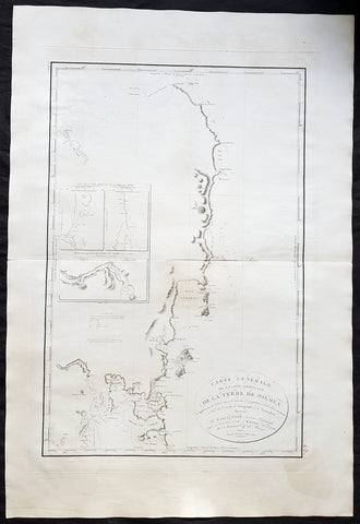
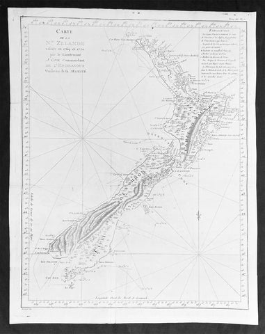
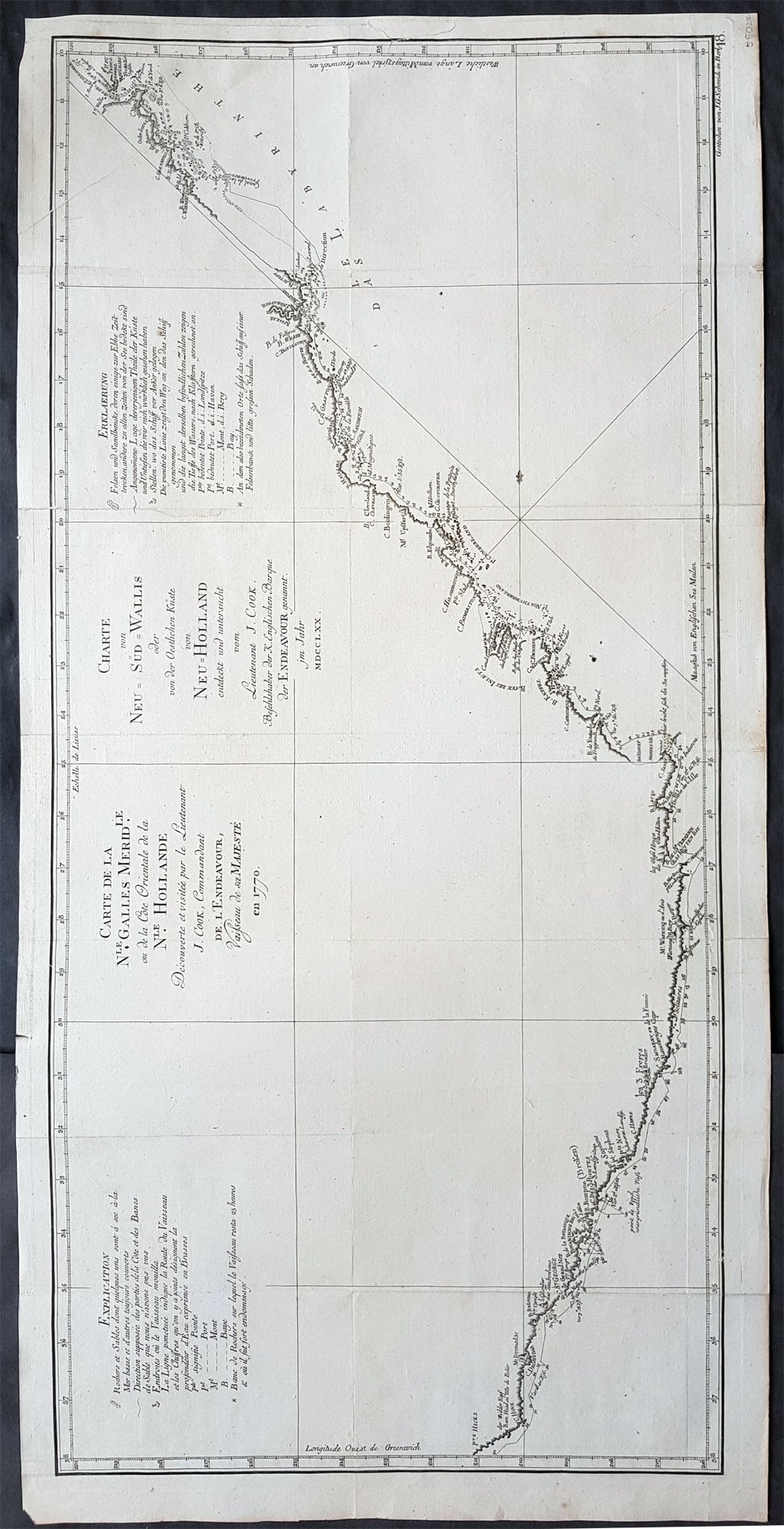
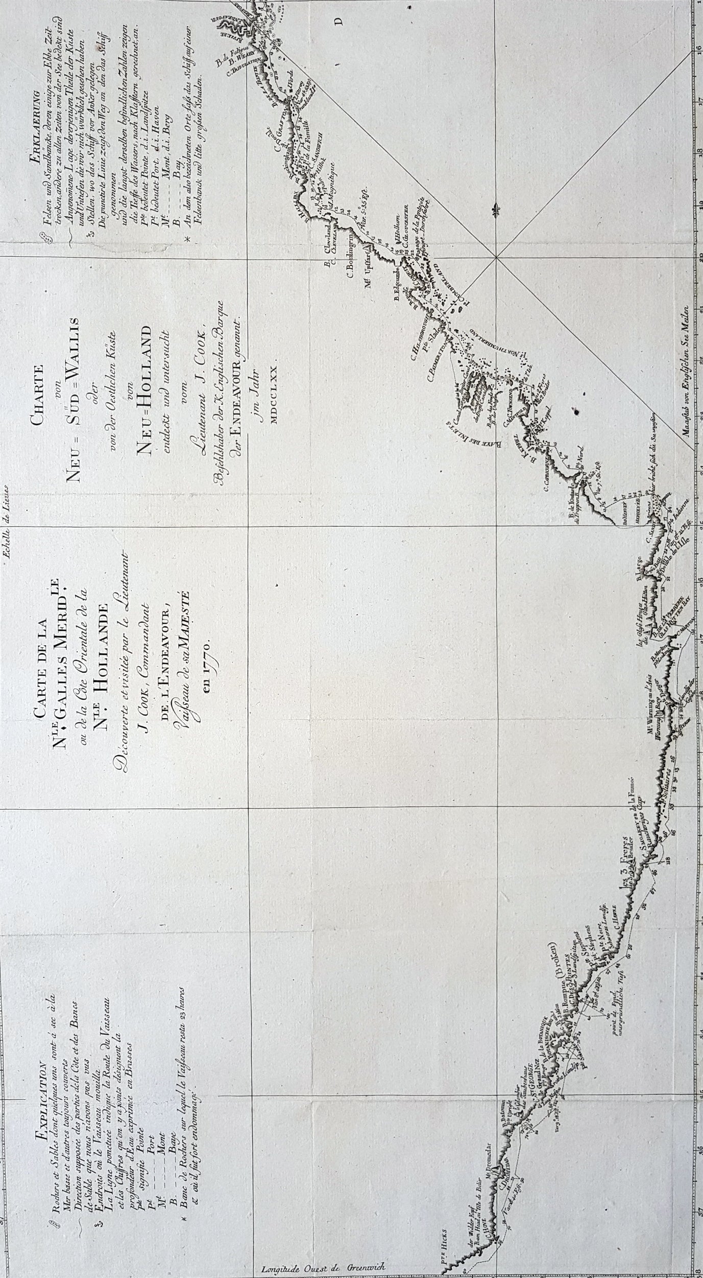
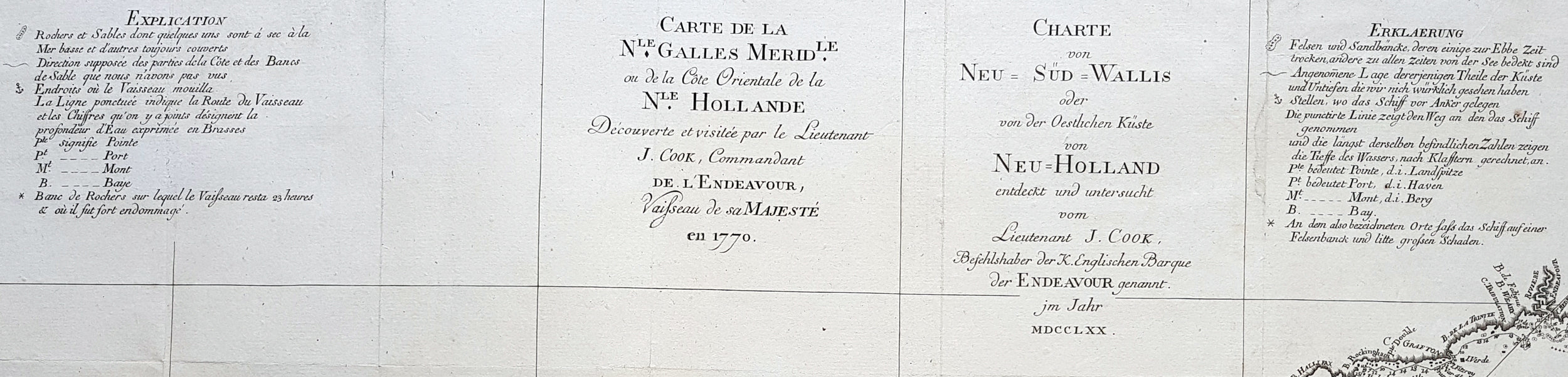
Description:This fine original copper-plate engraved, large antique map, a chart of the East Coast of Australia - from Point Hicks in Victoria to Cape York in Queensland - by Captain James Cook during his first Voyage of Discovery to the South Seas, in 1769-70, was engraved by J G Schmidi - after Captain Cook - and was published in the 1774 German translation of John Hawkesworths publication An Account of the Voyages Undertaken by the Order of His Present Majesty for Making Discoveries in the Southern Hemisphere and Successively Performed by Commodore Byron, Captain Wallis, Captain Carteret, and Captain Cook, in the Dolphin, the Swallow, and the Endeavor, Drawn Up from the Journals Which Were Kept by the Several Commanders, and from the Papers of Joseph Banks
General Definitions:Paper thickness and quality: - Heavy and stablePaper color : - off whiteAge of map color: -Colors used: -General color appearance: -Paper size: - 32 1/4in x 16in (820mm x 405mm)Plate size: - 31in x 15in (790mm x 380mm)Margins: - Min 1/2in (12mm)
Imperfections:Margins: - NonePlate area: - Folds as issuedVerso: - None
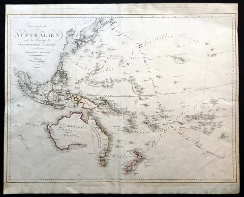
Background: 1st Chart of the East Coast of AustraliaCaptain James Cook is considered one of the most talented Surveyors & Map Makers of any age, for Cook, the production of a new chart was his principal reason for going to sea. His charts were aimed at fellow seamen so he incorporated as much information as possible while employing an economy of style and little elaboration. The quality of his charts can be confirmed by the fact that some survey details from Newfoundland to New Zealand & Australias East Coast could still be safely used over one hundred years later. His last piece of the New Zealand hydrographic chart was only removed in the 1990s.Prior to the Endeavour voyage in 1768 to the South Seas, most existing charts of the Pacific were poor and imprecise and were virtually useless to Cook. Cook therefore had a largely blank canvas when he entered the Pacific. Four charts produced by Cook in the Pacific, during his 1st voyage, serve to demonstrate his ability and output. The charts of Tahiti, the New Hebrides (Vanuatu) New Zealand & the East Coast of Australia.On leaving Tahiti and the other Society Islands, Cook made a short attempt to find Terra Australis but the poor condition of the Endeavour soon forced him to head for New Zealand. Reaching there in early October 1769, Cook would remain for six months during which time he made a circumnavigation showing it comprised two main islands. Cook’s chart of New Zealand is one of his most famous (and rightly so) as it represents some of his best work with New Zealand immediately recognisable.After mapping New Zealand Cook then set course westwards, intending to strike for Van Diemens Land (present-day Tasmania, sighted by Tasman) to establish whether or not it formed part of the fabled southern continent. However, they were forced to maintain a more northerly course owing to prevailing gales, and sailed onwards until one afternoon when land was sighted, which Cook named Point Hicks. Cook calculated that Van Diemens Land ought to lie due south of their position, but having found the coastline trending to the south-west, recorded his doubt that this landmass was connected to it. This point was on the south-eastern coast of the Australian continent, and in doing so his expedition became the first recorded Europeans to have encountered its eastern coastline. In his journal, Cook recorded the event thus:.........the Southermost Point of land we had in sight which bore from us W1/4S I judged to lay in the Latitude of 38°..0\' S° and in the Longitude of 211°..07\' W t from the Meridion of Greenwich. I have named it Point Hicks, because Leuit t Hicks was the first who discover\'d this land...........The ships log recorded that land was sighted at 6 a.m. on Thursday 19 April 1770. Cooks log used the nautical date, which, during the 18th century, assigned the same date to all ships events from noon to noon, first p.m. and then a.m. That nautical date began twelve hours before the midnight beginning of the like-named civil date. Furthermore, Cook did not adjust his nautical date to account for circumnavigation of the globe until he had travelled a full 360° relative to the longitude of his home British port, either toward the east or west. Because he travelled west on his first voyage, this a.m. nautical date was the morning of a civil date 14 hours slow relative to his home port (port−14h). Because the south-east coast of Australia is now regarded as being 10 hours ahead relative to Britain, that date is now called Friday, 20 April.The landmark of this sighting is generally reckoned to be a point lying about half-way between the present-day towns of Orbost and Mallacoota on the south-eastern coast of the state of Victoria. A survey done in 1843 ignored or overlooked Cooks earlier naming of the point, giving it the name Cape Everard. On the 200th anniversary of the sighting, the name was officially changed back to Point Hicks.Endeavour continued northwards along the coastline, keeping the land in sight with Cook charting and naming landmarks as he went. A little over a week later, they came across an extensive but shallow inlet, and upon entering it moored off a low headland fronted by sand dunes. James Cook and crew made their first landing on the continent, at a place now known as Botany Bay, on the Kurnell Peninsula and made contact of a hostile nature with the Gweagal Aborigines, on 29 April.[b] At first Cook bestowed the name Sting-Ray Harbour to the inlet after the many such creatures found there; this was later changed to Botanist Bay[27] and finally Botany Bay after the unique specimens retrieved by the botanists Joseph Banks, Daniel Solander and Herman Spöring.This first landing site was later to be promoted (particularly by Joseph Banks) as a suitable candidate for situating a settlement and British colonial outpost. However, almost 18 years later, when Captain Arthur Phillip and the First Fleet arrived in early 1788 to establish an outpost and penal colony, they found that the bay and surrounds did not live up to the promising picture that had been painted. Instead, Phillip gave orders to relocate to a harbour a few kilometres to the north, which Cook had named Port Jackson but had not further explored. It was in this harbour, at a place Phillip named Sydney Cove, that the settlement of Sydney was established. The settlement was for some time afterwards still referred to generally as Botany Bay. The expeditions scientific members commenced the first European scientific documentation of Australian fauna and flora.At Cooks original landing contact was made with the local Australian Aboriginal inhabitants. As the ships sailed into the harbour, they noticed Aborigines on both of the headlands. At about 2 pm they put the anchor down near a group of six to eight huts. Two Aborigines, a younger and an older man, came down to the boat.[citation needed] They did not accept the offer of gifts from Cook, whose lack of knowledge of Aboriginal custom may have prevented him from behaving acceptably in such exchanges. A musket was fired over their heads, which wounded the older man slightly, and he ran towards the huts. He came back with other men and threw spears at Cooks men, although they did no harm.[citation needed] They were chased off after two more rounds were fired.[citation needed] The adults had left, but Cook found several Aboriginal children in the huts, and left some beads with them as a gesture of friendship.Cook continued northwards, charting along the coastline. He stopped at Bustard Bay (now known as 1770) at 8 o’clock on 23 May 1770 in 5 fathoms water on a sandy bottom at the South point of the Bay. Cook recounted that his clerk, Orton, had been molested while dead drunk that night, the perpetrators cutting off not only his clothes but also parts of his ears. Cook suspended and sent below the suspect Magra.[28] On 24 May Cook and Banks and others went ashore. He sounded the channel (now known as Round Hill Creek) and found a freshwater stream, noting there was room for a few ships to safely anchor. He noted a great deal of smoke on the hills and inspected one of the closest group of 10 fires around which were scattered cockle shells and other evidence of aboriginal occupation.A mishap occurred when Endeavour ran aground on a shoal of the Great Barrier Reef, on 11 June 1770. The ship was seriously damaged and his voyage was delayed almost seven weeks while repairs were carried out on the beach (near the docks of modern Cooktown, at the mouth of the Endeavour River). While there, Joseph Banks, Herman Spöring and Daniel Solander made their first major collections of Australian flora. The crews encounters with the local Aboriginal people were mainly peaceable; from the group encountered here the name kangaroo entered the English language, coming from the local Guugu Yimidhirr word for a kind of Grey Kangaroo, gangurru (pronounced [ɡ̊aŋuru])Once repairs were complete the voyage continued, eventually passing by the northernmost point of Cape York Peninsula and then sailing through Torres Strait between Australia and New Guinea, earlier navigated by Luis Váez de Torres in 1606. Having rounded the Cape, Cook landed on Possession Island on 22 August, where he claimed the entire coastline he had just explored (later naming the region New South Wales) for the British Crown.In negotiating the Torres Strait past Cape York, Cook also put an end to the speculation that New Holland and New Guinea were part of the same land mass.John Hawkesworth An English writer and journalist, Hawkesworth was commissioned by the British Admiralty to edit for publication the narratives of its officers’ circumnavigations. He was given full access to the journals of the commanders and the freedom to adapt and re-tell them in the first person. Cook was already on his way back from his second Pacific voyage, temporarily docked at Cape Town (South Africa), when he first saw the published volumes: he was mortified and furious to find that Hawkesworth claimed in the introduction that Cook had seen and blessed (with slight corrections) the resulting manuscript. (In his defense, Hawkesworth also had been a victim of misunderstanding.) Cook had trouble recognizing himself. Moreover, the work was full of errors and commentary introduced by Hawkesworth and, in Cook’s view, too full of Banks, who had promoted himself and the publication. Still, the work was popular; the first edition sold out in several months.