Welcome to Classical Images!
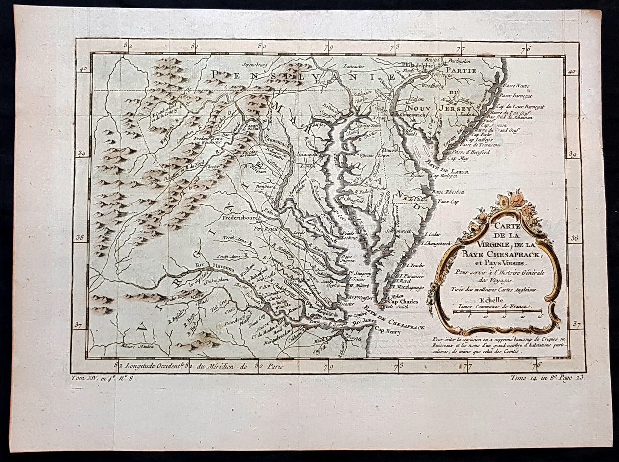
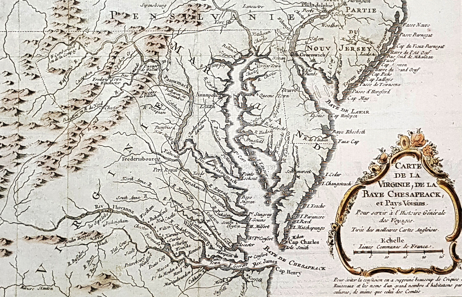
Description:This original hand coloured copper plate engraved antique map of Virginia, Chesapeake Bay, Maryland & parts of New Jersey & Pennsylvania - by Jacques Nicholas Bellin in 1757 - was published in the French edition of Antoine-François Prevosts 20 volume L Histoire Generale des Voyages published by Pierre de Hondt in the Hague between 1747 & 1785.
General Definitions:Paper thickness and quality: - Heavy and stablePaper color : - off whiteAge of map color: - EarlyColors used: - Yellow, green, blue, pinkGeneral color appearance: - AuthenticPaper size: - 13 1/2in x 10in (345mm x 245mm)Plate size: - 13in x 8 1/2in (330mm x 210mm)Margins: - Min 1/2in (12mm)
Imperfections:Margins: - Light age toning in marginsPlate area: - NoneVerso: - None
Background:In 1524, Italian explorer Giovanni da Verrazzano, (1485–1528), in service of the French crown, (famous for sailing through and thereafter naming the entrance to New York Bay as the Verrazzano Narrows, including now in the 20th century, a suspension bridge also named for him) sailed past the Chesapeake, but did not enter the Bay. Spanish explorer Lucas Vásquez de Ayllón sent an expedition out from Hispaniola in 1525 that reached the mouths of the Chesapeake and Delaware Bays. It may have been the first European expedition to explore parts of the Chesapeake Bay, which the Spaniards called Bahía de Santa María (Bay of St. Mary) or Bahía de Madre de Dios.(Bay of the Mother of God) De Ayllón established a short-lived Spanish mission settlement, San Miguel de Gualdape, in 1526 along the Atlantic coast. Many scholars doubt the assertion that it was as far north as the Chesapeake; most place it in present-day Georgias Sapelo Island. In 1573, Pedro Menéndez de Márquez, the governor of Spanish Florida, conducted further exploration of the Chesapeake. In 1570, Spanish Jesuits established the short-lived Ajacan Mission on one of the Chesapeake tributaries in present-day Virginia.The arrival of English colonists under Sir Walter Raleigh and Humphrey Gilbert in the late 16th century to found a colony, later settled at Roanoke Island (off the present-day coast of North Carolina) for the Virginia Company, marked the first time that the English approached the gates to the Chesapeake Bay between the capes of Cape Charles and Cape Henry. Three decades later, in 1607, Europeans again entered the Bay. Captain John Smith of England explored and mapped the Bay between 1607 and 1609, resulting in the publication in 1612 back in the British Isles of A Map of Virginia. Smith wrote in his journal: Heaven and earth have never agreed better to frame a place for mans habitation. The new laying out of the Captain John Smith Chesapeake National Historic Trail, the United States first designated all-water National Historic Trail, was created in July 2006, by the National Park Service of the U.S. Department of the Interior following the route of Smiths historic 17th-century voyage. Because of economic hardships and civil strife in the Mother Land, there was a mass migration of southern English Cavaliers and their servants to the Chesapeake Bay region between 1640 and 1675, to both of the new colonies of the Province of Virginia and the Province of Maryland.The Chesapeake Bay was the site of the Battle of the Chesapeake (also known as the Battle of the Capes, Cape Charles and Cape Henry) in 1781, during which the French fleet defeated the Royal Navy in the decisive naval battle of the American Revolutionary War. The British defeat enabled General George Washington and his French allied armies under Comte de Rochambeau to march down from New York and bottle up the rampaging southern British Army of Lord Cornwallis from the North and South Carolinas at the siege of Battle of Yorktown in Yorktown, Virginia. Their marching route from Newport, Rhode Island through Connecticut, New York State, Pennsylvania, New Jersey and Delaware to the Head of Elk by the Susquehanna River along the shores and also partially sailing down the Bay to Virginia. It is also the subject of a designated National Historic Trail under the National Park Service as the Washington-Rochambeau Revolutionary Route.The Bay would again see conflict during War of 1812. During the year of 1813, from their base on Tangier Island, British naval forces under the command of Admiral George Cockburn raided and plundered several towns on the shores of the Chesapeake, treating the Bay as if it were a British Lake. The Chesapeake Bay Flotilla, a fleet of shallow-draft armed barges under the command of U.S. Navy Commodore Joshua Barney, was assembled to stall British shore raids and attacks. After months of harassment by Barney, the British landed on the west side of the Patuxent at Benedict, Maryland, the Chesapeake Flotilla was scuttled, and the British trekked overland to burn the U.S. Capitol in August 1814. A few days later in a pincer attack, they also sailed up the Potomac River to attack Fort Washington below the National Capital and demanded a ransom from the nearby port town of Alexandria, Virginia.There were so-called Oyster Wars in the late 19th and early 20th centuries. Until the mid-20th century, oyster harvesting rivaled the crab industry among Chesapeake watermen, a dwindling breed whose skipjacks and other workboats were supplanted by recreational craft in the latter part of the century.In the 1960s, the Calvert Cliffs Nuclear Power Plant on the historic Calvert Cliffs in Calvert County on the Western Shore of Maryland began using water from the Bay to cool its reactor.