Welcome to Classical Images!
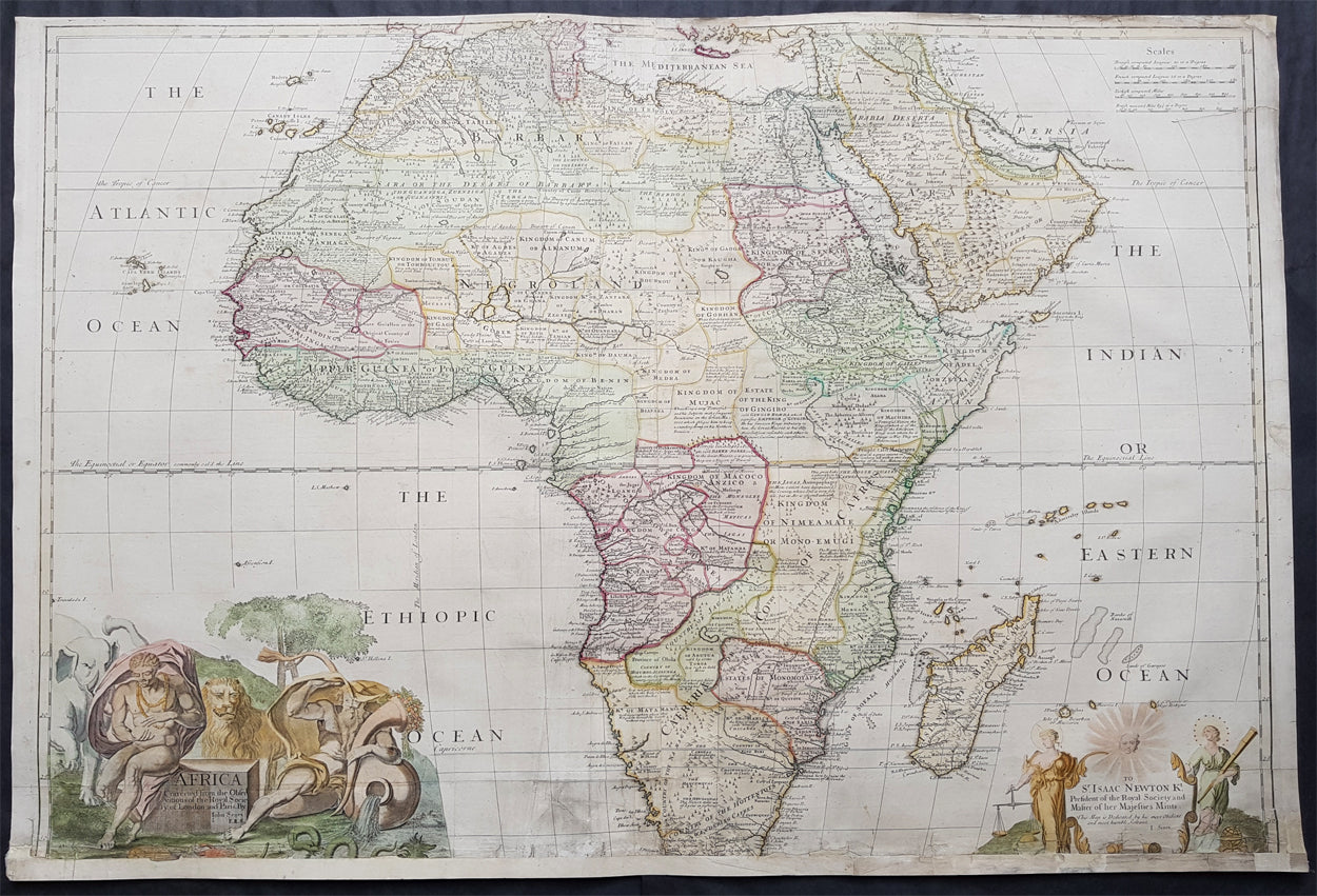
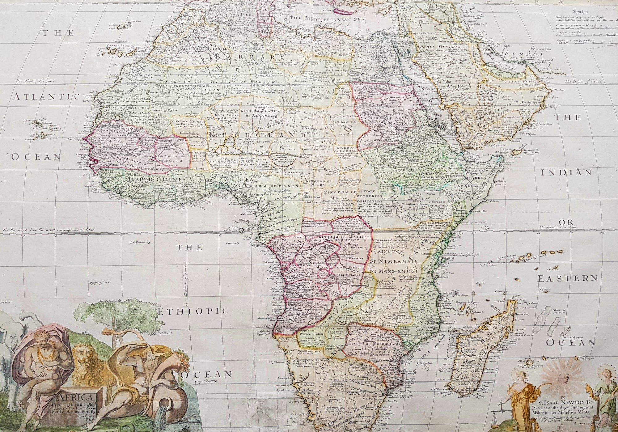
Description: This very large, beautifully hand coloured and incredibly scarce original antique map of Africa was published by John Senex in the 1720 edition of his Elephant Folio General Atlas.
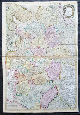
This large rare two sheet map provides a highly detailed look of the coastal regions along with the interior of Africa, at a time when it was still very much the Dark Continent. Also included are many annotations, including apocryphal notes regarding local peoples, animals, indigenous gems, mines, etc. The map has undergone some restoration. These very large maps were subjected to adverse handling conditions over the centuries, making actual survival rare. This map has been backed onto archival Japanese tissue, with the bottom missing 1 1/2in re-enforced. This map sells normally retail up to $3500 (based on condition)
Condition Report: Paper thickness and quality: - Heavy and stable Paper colour: - Off white Age of map colour: - Original & early Colours used: - Yellow, pink, green General colour appearance: - Authentic Paper size: - 40in x 27in (1.10m x 685mm) Plate size: - 38in x 27in (960mm x 685mm) Margins: - Min 1/4in (5mm)
Imperfections: Margins: - Bottom 1 1/2in of margin & image cropped Plate area: - Soiling and several repairs to bottom of map adjacent to centerfold Verso: - Backed with archival Japanese tissue, repairs as noted
Background: Good example of the large Senex map of Africa, dedicated to Sir Isaac Newton. " President of the Royal Society and Master of His Majesty's Mint." Newton served as President of the Royal Society from 1703 to 1727 and Master of the Mint from 1700 to 1727. According to E.H. Lane-Pool, The Discovery of Africa . . . As Reflected in the Maps in the Collection of the Rhodes-LIvingstone Museum (1950)......."The dedication suggests that [Newton] was holding his post under Queen Anne, at the time the map was produced.. The topography is based on the later de L'Isle maps . . . the Portuguese discoveries inserted . . . much curious information is derived from the commentaries appended to the placenames. Of the Hensquas, a people inhabiting the country of Griquas, it is said, "This nations makes use of Lyons in fighting?' At the source of the Buffalo River is the note "This river is said to have no end." The Zimbas in what now is Nyasaland are "Anthropophagi or men-eaters who pay divine worship to their King", and Mount Chiri (near the Shire river) is aptly described as "very fertile and populous. " John Cassangi becomes established at the headwaters of the Cuneni River about this period. His town was a famous market for traders in transit from the interior, and was the limit of Portuguese Exploration from the West Coast. Seventy years later Cassangi was an embarrassment to the Portuguese on account of the embargo he placed upon trade between Mwatayamvu an the West Coast"
Being part of the Mediterranean world, the northern coasts of the African continent as far as the Straits of Gibraltar and even round to the area of the Fortunate Isles (the Canaries) were reasonably well known and quite accurately mapped from ancient times. In particular, Egypt and the Nile Valley were well defined and the Nile itself was, of course, one of the rivers separating the continents in medieval T-O maps. Through Arab traders the shape of the east coast, down the Red Sea as far as the equator, was also known but detail shown in the interior faded into deserts with occasional mountain ranges and mythical rivers. The southern part of the continent, in the Ptolemaic tradition, was assumed to curve to the east to form a land-locked Indian Ocean. The voyages of the Portuguese, organized by Henry the Navigator in the fifteenth century, completely changed the picture and by the end of the century Vasco da Gama had rounded the Cape enabling cartographers to draw a quite presentable coastal outline of the whole continent, even if the interior was to remain largely unknown for the next two or three centuries. The first separately printed map of Africa (as with the other known continents) appeared in Munster's Geographia from 1540 onwards and the first atlas devoted to Africa only was published in 1588 in Venice by Livio Sanuto, but the finest individual map of the century was that engraved on 8 sheets by Gastaldi, published in Venice in 1564. Apart from maps in sixteenth-century atlases generally there were also magnificent marine maps of 1596 by Jan van Linschoten (engraved by van Langrens) of the southern half of the continent with highly imaginative and decorative detail in the interior. In the next century there were many attractive maps including those of Mercator/Hondius (1606), Speed (1627), Blaeu (1 630), Visscher (1636), de Wit (c. 1670), all embellished with vignettes of harbours and principal towns and bordered with elaborate and colourful figures of their inhabitants, but the interior remained uncharted with the exception of that part of the continent known as Ethiopia, the name which was applied to a wide area including present-day Abyssinia. Here the legends of Prester John lingered on and, as so often happened in other remote parts of the world, the only certain knowledge of the region was provided by Jesuit missionaries. Among these was Father Geronimo Lobo (1595-1678), whose work A Voyage to Abyssinia was used as the basis for a remarkably accurate map published by a German scholar, Hiob Ludolf in 1683. Despite the formidable problems which faced them, the French cartographers G. Delisle (c. 1700-22), J. B. B. d'Anville (1727-49) and N. Bellin (1754) greatly improved the standards of mapping of the continent, improvements which were usually, although not always, maintained by Homann, Seutter, de Ia Rochette, Bowen, Faden and many others in the later years of the century. (Ref: Tooley, Koeman)