
John Tallis (fl1838-51)
John Tallis and Co. were London map publishers who traded under various names: L. Tallis, Tallis & co, John Tallis, John Tallis & co. (London & New York) between 1838 and 1851.
In 1849 Tallis & co. published the Illustrated Atlas of the World with the maps and decorative vignette’s engraved and drawn by J. Rapkin. This atlas was one of the last atlases to be truly decorated and is therefore much sort after.
After 1850-51 their maps were published by the London Printing and Publishing Co., London and New York.
John Tallis (13)
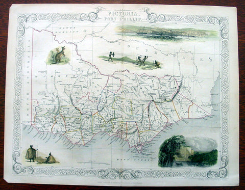
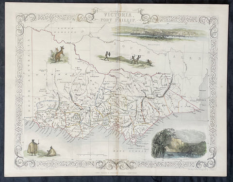
1851 Tallis Antique Map of Victoria or Port Phillip, Australia
- Title : Victoria or Port Phillip
- Ref #: 35089
- Size: 14 1/2in x 10 1/2in (370mm x 270mm)
- Date : 1851
- Condition: (A+) Fine Condition
Description:
This beautifully hand coloured original antique map of Victoria - Port Phillip - was engraved by John Rapkin and published by John Tallis in 1851.
The firm of Tallis & Company flourished from 1835 to 1860 with varying imprints. Their illustrated Atlas of 1850-51 was one of the last decorative atlases, all the maps being engraved on steel and all adorned with small vignettes. (Ref: Tooley; M&B)
General Description:
Paper thickness and quality: - Heavy and stable
Paper color: - off white
Age of map color: - Original & later
Colors used: - Yellow, green, red, brown.
General color appearance: - Authentic
Paper size: - 14 1/2in x 10 1/2in (370mm x 270mm)
Plate size: - 14 1/2in x 10 1/2in (370mm x 270mm)
Margins: - Min 1/2in (10mm)
Imperfections:
Margins: - Light age toning
Plate area: - None
Verso: - None
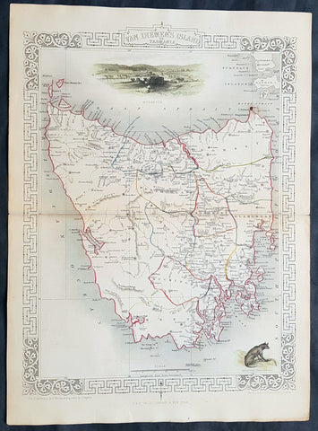
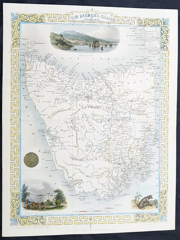
1851 John Tallis Antique map of Tasmania or Van Diemens Land, Australia
- Title : Van Diemens Land or Tasmania
- Ref #: 35512
- Size: 15in x 11in (380mm x 280mm)
- Date : 1851
- Condition: (A+) Fine Condition
Description:
This beautifully hand coloured original antique map of Van Diemens Land, Tasmania was engraved by John Rapkin and published by John Tallis in 1851.
General Description:
Paper thickness and quality: - Heavy and stable
Paper color: - off white
Age of map color: - Original & later
Colors used: - Yellow, green, red, brown.
General color appearance: - Authentic
Paper size: - 14 1/2in x 10 1/2in (370mm x 270mm)
Plate size: - 14 1/2in x 10 1/2in (370mm x 270mm)
Margins: - Min 1/2in (10mm)
Imperfections:
Margins: - Light age toning
Plate area: - None
Verso: - None
Background:
The firm of Tallis & Company flourished from 1835 to 1860 with varying imprints. Their illustrated Atlas of 1850-51 was one of the last decorative atlases, all the maps being engraved on steel and all adorned with small vignettes. (Ref: Tooley; M&B)
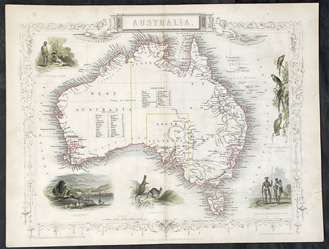
1851 John Tallis Antique Map of Australia
- Title : Australia
- Date : 1851
- Size: 14in x 11in (355mm x 280mm)
- Condition: (A+) Fine Condition
- Ref: 35511
Description:
This original hand coloured, steel plate engraved antique map of Australia with vignettes of Sydney Harbour, Aboriginals, Parrots and Kangaroos was engraved by John Rapkin and published by John Tallis in 1851.
General Definitions:
Paper thickness and quality: - Heavy and stable
Paper color : - off white
Age of map color: - Original
Colors used: - Blue
General color appearance: - Authentic
Paper size: - 14in x 11in (355mm x 280mm)
Plate size: - 14in x 11in (355mm x 280mm)
Margins: - Min 1/2in (12mm)
Imperfections:
Margins: - None
Plate area: - None
Verso: - None
Background:
The firm of Tallis & Company flourished from 1835 to 1860 with varying imprints. Their illustrated Atlas of 1850-51 was one of the last decorative atlases, all the maps being engraved on steel and all adorned with small vignettes. (Ref: Tooley; M&B)
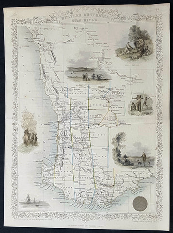
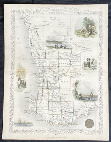
1851 John Tallis Antique Map of Western Australia or the Swan River Colony
- Title : Western Australia Swan River
- Size: 14in x 10 1/2in (355mm x 265mm)
- Condition: (A+) Fine Condition
- Date : 1851
- Ref #: 93056
Description:
This original hand coloured steel plate engraved antique map of Western Australia, the Swan River Colony with vignettes of Perth from Kings Park, Swan River, Aboriginals and Sheep Farming by John Rapkin and published by John Tallis in 1851.
General Definitions:
Paper thickness and quality: - Heavy and stable
Paper color : - off white
Age of map color: - Original
Colors used: - Yellow, green, blue, pink
General color appearance: - Authentic
Paper size: - 14in x 10 1/2in (355mm x 265mm)
Plate size: - 14in x 10 1/2in (355mm x 265mm)
Margins: - Min 1/2in (12mm)
Imperfections:
Margins: - Very light age toning in margins
Plate area: - None
Verso: - None
1851 John Tallis Beautiful Antique Map of Van Diemens Land or Tasmania Australia
- Title : Van Diemens Land or Tasmania...John Tallis
- Size: 14in x 11in (355mm x 280mm)
- Condition: (A+) Fine Condition
- Date : 1851
- Ref #: 93054
Description:
This original steel plate engraved beautifully hand coloured antique map Van Diemens Land or Tasmania, Australia with vignettes of Hobart, Circular Head and Tasmanian Tiger, by John Rapkin and published by John Tallis in 1851.
General Definitions:
Paper thickness and quality: - Heavy and stable
Paper color : - off white
Age of map color: - Original & later
Colors used: - Blue, pink, red, green, yellow
General color appearance: - Authentic
Paper size: - 14in x 11in (355mm x 280mm)
Plate size: - 14in x 11in (355mm x 280mm)
Margins: - Min 1in (25mm)
Imperfections:
Margins: - None
Plate area: - None
Verso: - None
Background:
The first reported sighting of Tasmania by a European was on 24 November 1642 by Dutch explorer Abel Tasman, who landed at todays Blackman Bay. More than a century later, in 1772, a French expedition led by Marc-Joseph Marion du Fresne landed at (nearby but different) Blackmans Bay, and the following year Tobias Furneaux became the first Englishman to land in Tasmania when he arrived at Adventure Bay, which he named after his ship HMS Adventure. Captain James Cook also landed at Adventure Bay in 1777. Matthew Flinders and George Bass sailed through Bass Strait in 1798–99, determining for the first time that Tasmania was an island.
Sealers and whalers based themselves on Tasmanias islands from 1798, and in August 1803 New South Wales Governor Philip King sent Lieutenant John Bowen to establish a small military outpost on the eastern shore of the Derwent River in order to forestall any claims to the island by French explorers who had been exploring the southern Australian coastline. Bowen, who led a party of 49, including 21 male and three female convicts, named the camp Risdon. Several months later a second settlement was established by Captain David Collins, with 308 convicts, 5 kilometres (3.1 mi) to the south in Sullivans Cove on the western side of the Derwent, where fresh water was more plentiful. The latter settlement became known as Hobart Town or Hobarton, later shortened to Hobart, after the British Colonial Secretary of the time, Lord Hobart. The settlement at Risdon was later abandoned. Left on their own without further supplies, the Sullivans Cove settlement suffered severe food shortages and by 1806 its inhabitants were starving, with many resorting to scraping seaweed off rocks and scavenging washed-up whale blubber from the shore to survive.
A smaller colony was established at Port Dalrymple on the Tamar River in the islands north in October 1804 and several other convict-based settlements were established, including the particularly harsh penal colonies at Port Arthur in the southeast and Macquarie Harbour on the West Coast. Tasmania was eventually sent 75,000 convicts—four out of every ten people transported to Australia. By 1819 the Aboriginal and British population reached parity with about 5000 of each, although among the colonists men outnumbered women four to one. Wealthy middle-class free settlers began arriving in large numbers from 1820, lured by the promise of land grants and free convict labour. Settlement in the islands northwest corner was monopolised by the Van Diemens Land Company, which sent its first surveyors to the district in 1826. By 1830 one-third of Australias non-Indigenous population lived in Van Diemens Land and the island accounted for about half of all land under cultivation and exports.
Van Diemens Land—which thus far had existed as a territory within the colony of New South Wales—was proclaimed a separate colony, with its own judicial establishment and Legislative Council, on 3 December 1825. Transportation to the island ceased in 1853 and the colony was renamed Tasmania in 1856, partly to differentiate the burgeoning society of free settlers from the islands convict past.
The Legislative Council of Van Diemens Land drafted a new constitution which it passed in 1854. The following year the Privy Council approved the colony changing its name from Van Diemens Land to Tasmania, and in 1856 the newly elected bicameral parliament sat for the first time, establishing Tasmania as a self-governing colony of the British Empire.
The colony suffered from economic fluctuations, but for the most part was prosperous, experiencing steady growth. With few external threats and strong trade links with the Empire, Tasmania enjoyed many fruitful periods in the late 19th century, becoming a world-centre of shipbuilding. It raised a local defence force that eventually played a significant role in the Second Boer War in South Africa, and Tasmanian soldiers in that conflict won the first two Victoria Crosses awarded to Australians.
In 1901 the Colony of Tasmania united with the five other Australian colonies to form the Commonwealth of Australia. Tasmanians voted in favour of federation with the largest majority of all the Australian colonies.
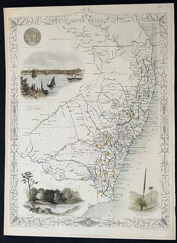
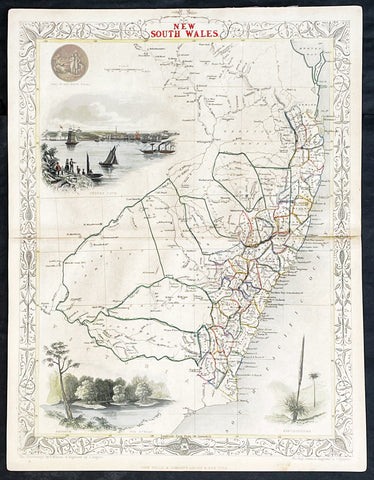
1851 John Tallis Antique Map of The Colony of New South Wales, Australia
- Title : New South Wales
- Size: 14in x 10 1/2in (355mm x 265mm)
- Condition: (A+) Fine Condition
- Date : 1851
- Ref #: 93055
Description:
This original hand coloured steel plate engraved antique map of the Colony of New South Wales with vignettes of Sydnet Cove, Murray River by John Rapkin and published by John Tallis in 1851.
General Definitions:
Paper thickness and quality: - Heavy and stable
Paper color : - off white
Age of map color: - Original
Colors used: - Yellow, green, blue, pink
General color appearance: - Authentic
Paper size: - 14in x 10 1/2in (355mm x 265mm)
Plate size: - 14in x 10 1/2in (355mm x 265mm)
Margins: - Min 1/2in (12mm)
Imperfections:
Margins: - Very light age toning in margins
Plate area: - None
Verso: - None
1851 John Tallis Antique Map of Western Australia or The Swan River Settlement
- Title : Western Australia Swan River
- Date : 1851
- Size: 14in x 11in (355mm x 280mm)
- Condition: (A+) Fine Condition
- Ref: 35523
Description:
This original hand coloured, steel plate engraved antique map of Western Australia or The Swan River Settlement, Australia with vignettes of Perth, Fremantle, Aboriginals and settlers was engraved by John Rapkin and published by John Tallis in 1851.
General Definitions:
Paper thickness and quality: - Heavy and stable
Paper color : - off white
Age of map color: - Original
Colors used: - Blue
General color appearance: - Authentic
Paper size: - 14in x 11in (355mm x 280mm)
Plate size: - 14in x 11in (355mm x 280mm)
Margins: - Min 1/2in (12mm)
Imperfections:
Margins: - None
Plate area: - None
Verso: - None
Background:
The firm of Tallis & Company flourished from 1835 to 1860 with varying imprints. Their illustrated Atlas of 1850-51 was one of the last decorative atlases, all the maps being engraved on steel and all adorned with small vignettes. (Ref: Tooley; M&B)
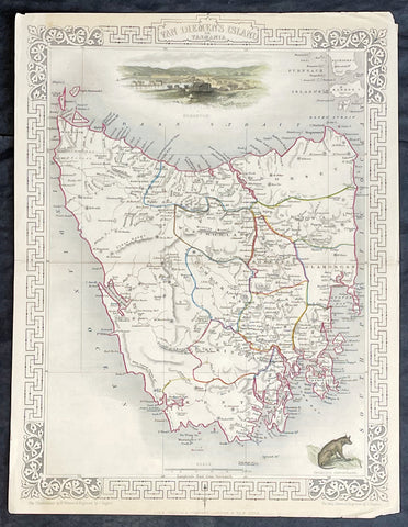
1851 John Tallis Antique Map of Van Diemens Land or Tasmania, Australia
- Title : Van Diemens Land or Tasmania
- Date : 1851
- Size: 14in x 11in (355mm x 280mm)
- Condition: (A+) Fine Condition
- Ref: 35519
Description:
This original hand coloured, steel plate engraved antique map of Tasmania, Australia with vignettes of Hobart and Tasmanian Tiger was engraved by John Rapkin and published by John Tallis in 1851.
General Definitions:
Paper thickness and quality: - Heavy and stable
Paper color : - off white
Age of map color: - Original
Colors used: - Blue
General color appearance: - Authentic
Paper size: - 14in x 11in (355mm x 280mm)
Plate size: - 14in x 11in (355mm x 280mm)
Margins: - Min 1/2in (12mm)
Imperfections:
Margins: - None
Plate area: - None
Verso: - None
Background:
The firm of Tallis & Company flourished from 1835 to 1860 with varying imprints. Their illustrated Atlas of 1850-51 was one of the last decorative atlases, all the maps being engraved on steel and all adorned with small vignettes. (Ref: Tooley; M&B)
1851 John Tallis Antique Map of Victoria or Port Phillip, Australia
- Title : Victoria or Port Phillip
- Date : 1851
- Size: 14in x 11in (355mm x 280mm)
- Condition: (A+) Fine Condition
- Ref: 35503
Description:
This original hand coloured, steel plate engraved antique map of Victoria, Australia with vignettes of Glenelg River, Aboriginals and Kangaroos was engraved by John Rapkin and published by John Tallis in 1851.
General Definitions:
Paper thickness and quality: - Heavy and stable
Paper color : - off white
Age of map color: - Original
Colors used: - Blue
General color appearance: - Authentic
Paper size: - 14in x 11in (355mm x 280mm)
Plate size: - 14in x 11in (355mm x 280mm)
Margins: - Min 1/2in (12mm)
Imperfections:
Margins: - None
Plate area: - None
Verso: - None
Background:
The firm of Tallis & Company flourished from 1835 to 1860 with varying imprints. Their illustrated Atlas of 1850-51 was one of the last decorative atlases, all the maps being engraved on steel and all adorned with small vignettes. (Ref: Tooley; M&B)
1851 John Tallis Antique Map of New South Wales, Australia
- Title : New South Wales
- Date : 1851
- Size: 14in x 11in (355mm x 280mm)
- Condition: (A+) Fine Condition
- Ref: 1554
Description:
This original hand coloured, steel plate engraved antique map of New South Wales, Australia with vignettes of Sydney Harbour and The Murray was engraved by John Rapkin and published by John Tallis in 1851.
General Definitions:
Paper thickness and quality: - Heavy and stable
Paper color : - off white
Age of map color: - Original
Colors used: - Blue
General color appearance: - Authentic
Paper size: - 14in x 11in (355mm x 280mm)
Plate size: - 14in x 11in (355mm x 280mm)
Margins: - Min 1/2in (12mm)
Imperfections:
Margins: - None
Plate area: - None
Verso: - None
Background:
The firm of Tallis & Company flourished from 1835 to 1860 with varying imprints. Their illustrated Atlas of 1850-51 was one of the last decorative atlases, all the maps being engraved on steel and all adorned with small vignettes. (Ref: Tooley; M&B)
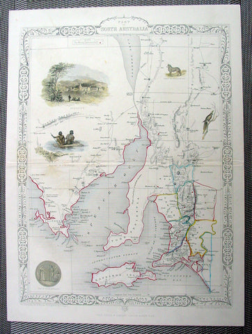
1851 Tallis Antique Map of South Australia
- Title : Part of South Australia
- Ref #: 22126
- Size: 14in x 10 ½in (355mm x 265mm)
- Date : 1851
- Condition: (A+) Fine Condition
Description:
This finely engraved beautifully hand coloured original antique map of South Australia - with several vignettes of Adelaide, Aboriginals and various wildlife - was engraved by John Rapkin and published by John Tallis in 1851.
The firm of Tallis & Company flourished from 1835 to 1860 with varying imprints. Their illustrated Atlas of 1850-51 was one of the last decorative atlases, all the maps being engraved on steel and all adorned with small vignettes. (Ref: Tooley; M&B)
General Description:
Paper thickness and quality: - Heavy and stable
Paper color: - off white
Age of map color: - Original & later
Colors used: - Yellow, green, red, brown.
General color appearance: - Authentic
Paper size: - 14in x 10 ½in (355mm x 265mm)
Plate size: - 15in x 10 ½in (355mm x 265mm)
Margins: - Min 1/2in (10mm)
Imperfections:
Margins: - None
Plate area: - Light creasing along centerfold
Verso: - None
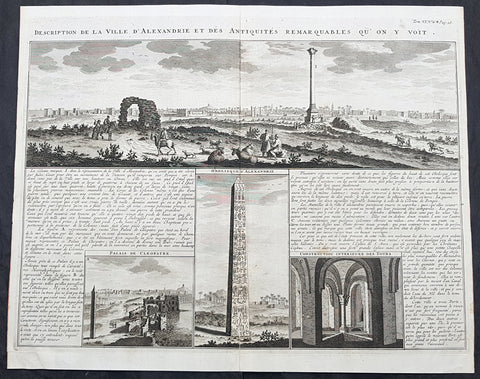
1719 Abraham Chatelain Large Antique Map Panoramic View of Alexandria, Egypt
- Title : Description de la Ville D Alexandrie des Antquites Remarquables Qu on Y Voit
- Size: 20in x 16in (515mm x 405mm)
- Condition: (A+) Fine Condition
- Date : 1719
- Ref #: 50649
Description:
This large original copper plate engraved antique print a view of the city of Alexandria, Egypt and the surrounding ancient ruins was published by Henri Abraham Chatelain in 1719, in his famous Atlas Historique.
General Definitions:
Paper thickness and quality: - Heavy and stable
Paper color : - off white
Age of map color: -
Colors used: -
General color appearance: -
Paper size: - 20in x 16in (515mm x 405mm)
Plate size: - 19in x 15in (485mm x 380mm)
Margins: - Min 1/2in (12mm)
Imperfections:
Margins: - None
Plate area: - None
Verso: - None
Background:
Alexandria is the second-largest city in Egypt and a major economic centre, extending about 32 km (20 mi) along the coast of the Mediterranean Sea in the north central part of the country. Its low elevation on the Nile delta makes it highly vulnerable to rising sea levels. Alexandria is an important industrial center because of its natural gas and oil pipelines from Suez. Alexandria is also a popular tourist destination.
Alexandria was founded around a small, ancient Egyptian town c. 332 BC by Alexander the Great, king of Macedon and leader of the Greek League of Corinth, during his conquest of the Achaemenid Empire. Alexandria became an important center of Hellenistic civilization and remained the capital of Ptolemaic Egypt and Roman and Byzantine Egypt for almost 1,000 years, until the Muslim conquest of Egypt in AD 641, when a new capital was founded at Fustat (later absorbed into Cairo). Hellenistic Alexandria was best known for the Lighthouse of Alexandria (Pharos), one of the Seven Wonders of the Ancient World; its Great Library (the largest in the ancient world); and the Necropolis, one of the Seven Wonders of the Middle Ages. Alexandria was at one time the second most powerful city of the ancient Mediterranean region, after Rome. Ongoing maritime archaeology in the harbor of Alexandria, which began in 1994, is revealing details of Alexandria both before the arrival of Alexander, when a city named Rhacotis existed there, and during the Ptolemaic dynasty.
Alexandria figured prominently in the military operations of Napoleons expedition to Egypt in 1798. French troops stormed the city on 2 July 1798, and it remained in their hands until the arrival of a British expedition in 1801. The British won a considerable victory over the French at the Battle of Alexandria on 21 March 1801, following which they besieged the city, which fell to them on 2 September 1801. Muhammad Ali, the Ottoman governor of Egypt, began rebuilding and redevelopment around 1810, and by 1850, Alexandria had returned to something akin to its former glory.
From the late 18th century, Alexandria became a major center of the international shipping industry and one of the most important trading centers in the world, both because it profited from the easy overland connection between the Mediterranean Sea and the Red Sea, and the lucrative trade in Egyptian cotton.
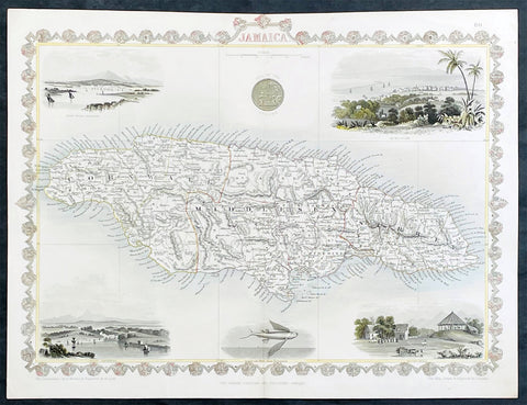
1851 John Tallis Antique map of the Island of Jamaica
- Title : Jamaica
- Date : 1851
- Size: 15in x 11in (380mm x 280mm)
- Condition: (A+) Fine Condition
- Ref: 35616
Description:
This original hand coloured copper plate engraved antique map of Jamaica, with decorative vignettes of Kingston, Port Antonio, Port Royal, a sugar mill and a flying fish, was published by John Tallis in 1851.
General Definitions:
Paper thickness and quality: - Heavy and stable
Paper color : - off white
Age of map color: - Original
Colors used: - Yellow, green, blue, pink
General color appearance: - Authentic
Paper size: - 15in x 11in (380mm x 280mm)
Plate size: - 15in x 10in (380mm x 255mm)
Margins: - Min 1/2in (12mm)
Imperfections:
Margins: - None
Plate area: - Light crease left side of image
Verso: - None