Sold (333)
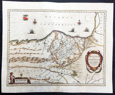
1639 Mercator Hondius Large Antique Map of Basque Region of Spain, Bilbao
- Title : Biscaia et Guipvscoa Cantabriae Veteris Pars
- Date : 1639
- Size: 21 1/2in x 18in (545mm x 460mm)
- Ref #: 43163
- Condition: (A) Very Good Condition
Description:
This beautiful, very significant original antique map of the Basque Region of Spain centered on Bilbao extending from S. Andero to Calgurris and Baiona by Jan Jansson was published in the 1639 French edition of Mercator's Atlas published by Henricus Hondius and Jan Jansson.
The text running for two pages on the back of the map generally describes the region or country name, history (as it was), temperature, seasons, soil and agricultural productivity. Also described is the topography, wildlife, local inhabitants their culture and religion, as well as a description of major European and local towns and cities. This text makes extremely enjoyable reading and a very good insight not only into the area described but the general European attitudes towards alien countries and cultures. (Ref: Suraz; Koeman; M&B; Tooley)
Condition Report:
Paper thickness and quality: - Heavy and stable
Paper color: - off white
Age of map color: - Later
Colors used: - Yellow, pink, green
General color appearance: - Authentic
Paper size: - 21 1/2in x 18in (545mm x 460mm)
Plate size: - 19 1/2in x 15in (495mm x 380mm)
Margins: - Min 1in (25mm)
Imperfections:
Margins: - Bottom centrefold & margin restored
Plate area: - Re-joined & light uplift along centrefold, light creasing
Verso: - Repairs as noted, light creasing
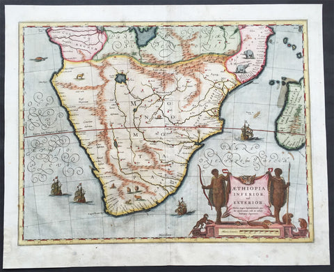
1641 Blaeu Large Old, Antique Map of Southern Africa - Aethopia, The Cape
- Title : Aethiopia Inferior vel Exterior...
- Date : 1641
- Condition: (A) Very Good Condition
- Ref: 92936
- Size: 22in x 18in (560mm x 460mm)
Description:
This beautifully hand coloured original antique map of South Africa was published in the 1641 German edition of Joan Blaeus Atlas Novus.
This handsome map formed the standard for the depiction of South Africa throughout the 17th century, covering the region from Congo-Zanzibar to the Cape. Both Blaeu & Jansson based this map on Portuguese exploration and most detail is confined to the coastlines. There are two large lakes in the interior, one unnamed and the other called Zachef, which is the lake out of which the Zambere (Zambesi River) flows, probably based on reports of Lake Ngami, which was not conclusively discovered until the mid 19th century. The interior shows the mythical Mountains of the Moon or Lunae Montes. Indigenous animals including elephants and monkeys are illustrated, while large galleons sail the sea. The dramatic title cartouche is drawn on an ox hide held up by natives, with monkeys and turtles at their feet. French text on verso.
Background:
The first separately printed map of Africa (as with the other known continents) appeared in Munster's Geographia from 1540 onwards and the first atlas devoted to Africa only was published in 1588 in Venice by Livio Sanuto, but the finest individual map of the century was that engraved on 8 sheets by Gastaldi, published in Venice in 1564. Apart from maps in sixteenth-century atlases generally there were also magnificent marine maps of 1596 by Jan van Linschoten (engraved by van Langrens) of the southern half of the continent with highly imaginative and decorative detail in the interior. In the next century there were many attractive maps including those of Mercator/Hondius (1606), Speed (1627), Blaeu (1 630), Visscher (1636), de Wit (c. 1670), all embellished with vignettes of harbours and principal towns and bordered with elaborate and colourful figures of their inhabitants, but the interior remained uncharted with the exception of that part of the continent known as Ethiopia, the name which was applied to a wide area including present-day Abyssinia. Here the legends of Prester John lingered on and, as so often happened in other remote parts of the world, the only certain knowledge of the region was provided by Jesuit missionaries. Among these was Father Geronimo Lobo (1595-1678), whose work A Voyage to Abyssinia was used as the basis for a remarkably accurate map published by a German scholar, Hiob Ludolf in 1683. Despite the formidable problems which faced them, the French cartographers G. Delisle (c. 1700-22), J. B. B. d'Anville (1727-49) and N. Bellin (1754) greatly improved the standards of mapping of the continent, improvements which were usually, although not always, maintained by Homann, Seutter, de Ia Rochette, Bowen, Faden and many others in the later years of the century. (Ref: Norwich; Tooley; M&B)
General Description:
Paper thickness and quality: - Heavy and stable
Paper color: - off white
Age of map color: - Early
Colors used: - Yellow, pink, red, blue, green
General color appearance: - Authentic
Paper size: - 22in x 18in (560mm x 460mm)
Plate size: - 20in x 15 1/2in (510mm x 395mm)
Margins: - Min 1in (25mm)
Imperfections:
Margins: - Small repair to left bottom margin, light soiling in margins
Plate area: - Bottom centerfold re-joined, no loss light soiling
Verso: - Light soiling
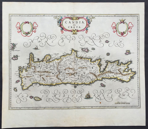
1642 Blaeu Antique Map of the Greek Island of Crete
- Title : Candia olim Creta
- Date : 1642
- Condition: (A+) Fine Condition
- Ref: 50009
- Size: 22 1/2in x 20in (570mmx 510mm)
Description:
This beautifully hand coloured original antique map of the Greek island of Crete was published in the 1642 Dutch edition of Joan Blaeu's Atlas Novus.
Background:
From the early days of map-making, cartographers have always had a keen interest he mapping of Greece and of the particular continental and insular Greek areas. In other words the "Greek chorography", as it is often called had been a cartographic item of special importance, both in manuscript and printed cartography, the later having produced an impressive number of Greek maps. All of these have been include in almost all the European Atlases and travel books, since the first printed edition of Ptolemy's Gepgraphia in1447. This prominent presence of Greece in the field of European cartography is due to various historic, political and cultural reasons.
In the first place, the Eastern Mediterranean basin has been for many centuries the center of the civilized European world and, consequently, an area of special attraction. It was only natural, therefore, that from the early days journeys to Greece made necessary the cartographic description of the region. The relevant mapping of the ancients was followed up and developed by the efficient Byzantium administration, thus providing a rich material which was later used by European cartographers of the 16th, 17th and 18th centuries.
Secondly, like any other artistic and scientific activity of the period under review, cartography was influenced by and reflected intense interest in Greece, enhanced by the revival of Greek culture and the flourishing of Classical studies during and after the renaissance.
Finally, the prolific production of Greek maps is due to the fact that, quite often cartographers used to delineate "historical" maps of Greece, with the ancient nomenclature and state structure, based manly on the Ptolemaic cartography and the works of all the classical authors, as well "contemporary" ones, which were the outcome of the journeys of travelers, merchants and intellectuals at the time. Greece was usually depicted as a province of the Ottoman empire or the Greek Islands as territories of the Venetian republic. Hence the distinction between maps of "Graecia Antiqua" and maps of "Graecia Nova" or "European Turkey" or "Southern part of Turkey in Europe" and the use of such Latin explanatory terms as "Olim" (formerly) and "Nunc" (presently) for the identification of places, according to their ancient (Greek, Latin) or contemporary (modern Greek, Turkish, Slavic, Italian) names.
Blaeu is one of the most revered map makers of all time and it is easy to see why in this beautiful original map.
The high level of the topographical detail, the quality of the paper, the artistic professionalism of the engraving and the beauty of the original hand colouring combine to produce a work of art that is both functional and of exceptional beauty. (Ref: Koeman; M&B)
General Description:
Paper thickness and quality: - Heavy and stable
Paper color: - off white
Age of map color: - Original
Colors used: - Yellow, pink, red, blue, green
General color appearance: - Authentic
Paper size: - 22 1/2in x 20in (570mmx 510mm)
Plate size: - 21in x 15 1/2in (535mm x 395mm)
Margins: - Min 1in (25mm)
Imperfections:
Margins: - None
Plate area: - None
Verso: - None
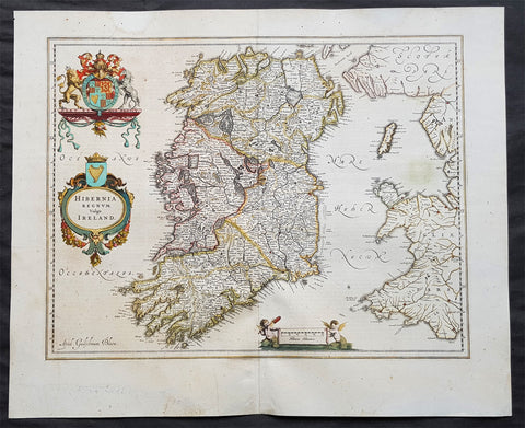
1642 Blaeu Large Old, Antique Map of Ireland - Hibernia Regnum
- Title: Hibernia Regnum Vulgo Ireland
- Size: 23 1/2in x 20in (600mm x 510mm)
- Ref # : 61159
- Date: 1642
- Condition: (A) Very Good Condition
Description:
This superbly hand coloured original antique map of Ireland - Hibernia - was published in the 1642 Dutch edition of Joan Blaeu's Atlas Novus.
Background:
This is Willem Blaeu's highly decorative general map of Ireland and is coloured to show in outline the ancient provinces of Connaught, Leinster, Munster and Ulster each of which together with the map of Carlow, was given a separate map in a section at the end of the atlas volume devoted to Scotland.
The map, which Blaeu first issued in 1635 (twenty years prior to the publication of the Scotland and Ireland volume) was based on that published by John Speed in 1611 in his Theatre of the Empire of Great Briatine. In its turn Speed's map was copied Hondius and Blaeu's great rival Jan Jansson. It was the latter version that Willem Blaeu used. His beautifully balanced design is complemented by the Royal arms and the relatively simple title cartouche at the left hand side. (Ref: Koeman; Tooley; M&B)
General Description:
Paper thickness and quality: - Heavy
Paper color: - White
Age of map color: - Original
Colors used: - Yellow, pink, red, blue, green
General color appearance: - Authentic
Paper size: - 23 1/2in x 19in (600mm x 485mm)
Plate size: - 19 3/4in x 15 1/4in (505mm x 385mm)
Margins: - Min 1in (25mm)
Imperfections:
Margins: - Light age toning
Plate area: - Light age toning
Verso: - Bottom section of centerfold re-joined, no loss
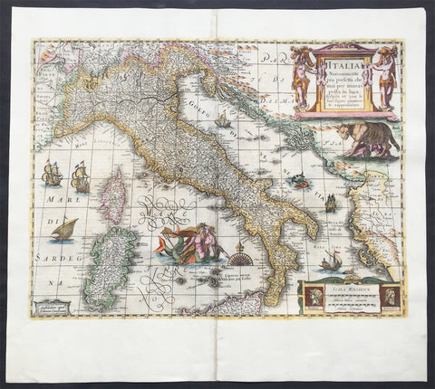
1644 Jan Jansson & Henricus Hondius Antique Map of Italy, Sardinia, Corsica
- Title : Italia Nuouamente piu perfetta chemai per inanzi posta
- Ref #: 61008
- Size: 21 1/2in x 19in (545mm x 490mm)
- Date : 1644
- Condition: (A) Very Good Condition
Description:
This fine beautifully hand coloured original antique map of Italy, Sicily, Sardinia & the Adriatic Coast by Jan Jansson was published in the 1644 German edition of Mercator's atlas by Jansson and Hondius.
This map is richly embellished with cartouches, sailing vessels, sea monsters and a wonderful rendering of Neptune and his mate. The image of the two mer-people embracing with bare chests is a hold over from the controversial images present in the first edition of Ortelius' modern map of Italy. Includes portraits of Romulus and Remus in the lower right corner. In subsequent years, Jansson would replace Hondius's name with his own in the bottom left corner.
General Description:
Paper thickness and quality: - Heavy and stable
Paper color: - off white
Age of map color: - Original
Colors used: - Green, red, orange, yellow, blue
General color appearance: - Authentic
Paper size: - 21 1/2in x 19in (545mm x 490mm)
Plate size: - 19 1/2in x 14 1/2in (500mm x 360mm)
Margins: - Min 1in (25mm)
Imperfections:
Margins: - Centrefold re-joined
Plate area: - Centrefold re-joined
Verso: - Centrefold re-joined
Background: Since classical times the countries bordering the enclosed waters of the Mediterranean had been well versed in the use of maps and sea charts and in Italy, more than anywhere else, the traditional knowledge was kept alive during the many hundreds of years following the collapse of the Roman Empire. By the thirteenth and fourteenth centuries the seamen of Venice, Genoa and Amalfi traded to far countries, from the Black Sea ports and the coasts of Palestine and Egypt in the East to Flanders and the southern coasts of England and Ireland in the West, their voyages guided by portulan charts and the use of the newly invented compass. For a time Italian supremacy in cartography passed to Aragon and the Catalan map makers based on Majorca, but by the year 1400 the power and wealth of the city states of Venice, Genoa, Florence and Milan surpassed any in Europe. Florence, especially, under the rule of the Medici family, became not only a great trading and financial centre but also the focal point of the rediscovery of the arts and learning of the ancient world. In this milieu a number of manuscript world maps were produced, of which one by Fra Mauro (c. 1459) is the most notable, but the event of the greatest importance in the history of cartography occurred in the year 1400 when a Florentine, Palla Strozzi, brought from Constantinople a Greek manuscript copy of Claudius Ptolemy'sGeographia, which, 1,250 years after its compilation, came as a revelation to scholars in Western Europe. In the following fifty years or so manuscript copies, translated into Latin and other languages, became available in limited numbers but the invention of movable-type printing transformed the scene: the first copy without maps being printed in 1475 followed by many with copper-engraved maps, at Bologna in 1477, Rome 1478, 1490, 1507 and 1508, and Florence 1482.
About the year 1485 the first book of sea charts, compiled by Bartolommeo dalli Sonetti, was printed in Venice and in the first part of the sixteenth century a number of world maps were published, among them one compiled in 1506 by Giovanni Contarini, engraved by Francesco Rosselli, which was the first printed map to show the discoveries in the New World. In the following years there were many attractive and unusual maps of Islands (Isolano) by Bordone, Camocio and Porcacchi, but more important was the work of Giacomo (Jacopo) Gastaldi, a native of Piedmont who started life as an engineer in the service of the Venetian Republic before turning to cartography as a profession. His maps, produced in great variety and quantity, were beautifully drawn copperplate engravings and his style and techniques were widely copied by his contemporaries. From about 1550 to 1580 many of Gastaldi's maps appeared in the collections of maps known as Lafreri 'atlases', a term applied to groups of maps by different cartographers brought together in one binding. As the contents of such collections varied considerably they were no doubt assembled at the special request of wealthy patrons and are now very rare indeed.
About this time, for a variety of historical and commercial reasons, Italy's position as the leading trading and financial nation rapidly declined and with it her superiority in cartography was lost to the vigorous new states in the Low Countries. That is not to say, of course, that Italian skills as map makers were lost entirely for it was not until 1620 that the first printed maps of Italy by an Italian, Giovanni Magini, appeared, and much later in the century there were fine maps by Giacomo de Rossi and Vincenzo Coronelli, the latter leading a revival of interest in cartography at the end of the century. Coronelli was also famous for the construction of magnificent large-size globes and for the foundation in Venice in 1680 of the first geographical society.
In the eighteenth century the best-known names are Antonio Zatta, Rizzi-Zannoni and Giovanni Cassini.
We ought to mention the work of Baptista Boazio who drew a series of maps in A Summarie and True Discourse of Sir Francis Drake's West Indian Voyage, published in 1588-89, and who is especially noted for a very fine map of Ireland printed in 1599 which was incorporated in the later editions of the Ortelius atlases. It is perhaps appropriate also to refer to two English map makers who spent many years in exile in Italy: the first, George Lily, famous for the splendid map of the British Isles issued in Rome in 1546, and the second, Robert Dudley, who exactly one hundred years later was responsible for the finest sea atlas of the day, Dell' Arcano del Mare,published in Florence. Both of these are described in greater detail elsewhere in this handbook. (Ref: Tooley, Koeman)
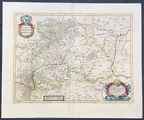
1646 Hondius Old, Antique Map of Henneberg, Thuringia Region Germany - Meiningen
- Title : Principatus Hennenbergensis
- Ref #: 50176
- Size: 22in x 19in (560mm x 480mm)
- Date : 1649
- Condition: (A+) Fine Condition
Description:
This beautifully hand coloured original antique map of the Henneberg county in the Thuringia region of Southern Germany - centering on the cities of Henneberg and Meiningen was published in the 1646 Latin edition of Mercators Atlas by Jan Jansson and Henricus Hondius. (Ref: Koeman; Tooley; M&B)
Condition Report:
Paper thickness and quality: - Heavy and stable
Paper color: - off white
Age of map color: - Original
Colors used: - Green, red, orange, yellow, blue
General color appearance: - Authentic and beautiful
Paper size: - 22in x 19in (560mm x 480mm)
Plate size: - 19 1/2in x 15in (495mm x 380mm)
Margins: - Min 1in (25mm)
Imperfections:
Margins: - Light age toning
Plate area: - Light age toning
Verso: - Light age toning
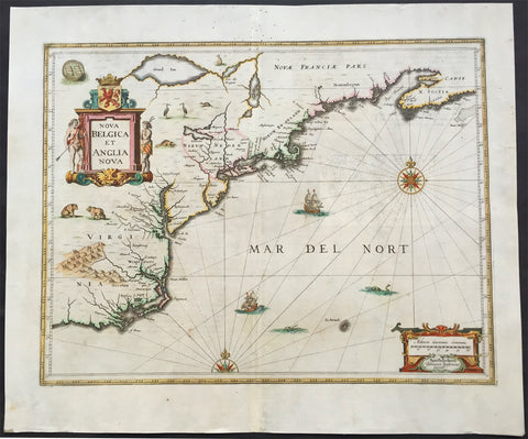
1646 Jansson Antique Map of America - Virginia, New Jersey, New York New England
- Title : Nova Belgium et Anglia Nova
- Ref #: 61018
- Size: 22 1/2in x 19in (570mm x 490mm)
- Date : 1646
- Condition: (A) Very Good Condition
Description:
This very important early original antique map of the north east region of The United States from Virginia to Chesapeake Bay and New England was published in the 1646 Latin edition of Jansson's Atlas Nouvs.
In excellent condition with a small professional repairs to bottom left margin corner, not affecting the image and backed with light transparent Japanese tissue. Please see below for a more detaile ddecsription.
Background: A great example of a very early American map derived from the less well circulated Johannes de Laet map of 1630. This version is enlarged and expanded to the north and slightly east. This version also carries de Laets narrative on the verso. (De Laets map is one of extreme importance, being the first printed to use the names Manbattes (Manhattan) and N. Amsterdam) The nomenclature on this map is virtually identical to the De Laet map, with the few minor differences most likely owing to the engravers error. C of Feare is still depicted over 2° too far south. This is not Cape Fear we know of today but actually Cape lookout.
During the fiercely competitive decade of the 1630's the families of Blaeu and Jansson produced maps drawn directly from one another. Here, however, Jansson produces one that was not followed by Blaeu, relying upon the more restricted map of Nova Belgica to represent the land north of Chesapeake Bay. A sign of the Dutch influence here is that both atlas producers largely declined to include the advanced cartography of Champlain, thereby relegating it altogether.
There are three know states of this map, the first one published in 1636 - entitled Nova Anglia Novvm Belgium et Virginia.
The second edition in which the title of the map was changed to Nova Belgium et Anglia Nova (to give more weight to Dutch claims in North America) within a new square cartouche was first published in 1647.
State 3 was published in 1694 by Schenk & Valk which included new regional demarcation and a latitude and longitude grid. (Ref: Koeman; M&B; Tooley; Burden; AMPR)
General Description:
Paper thickness and quality: - Heavy and stable
Paper color: - off white
Age of map color: - Original
Colors used: - Green, red, orange, yellow, blue
General color appearance: - Authentic
Paper size: - 22 1/2in x 19in (570mm x 490mm)
Plate size: - 20in x 15 1/2in (535mm x 395mm)
Margins: - Min 1in (25mm)
Imperfections:
Margins: - Small professional repair bottom left margin corner, light spotting in top margin, no affecting image
Plate area: - Light show-through, light creasing along margin
Verso: - Backed with light transparent Japanese tissue
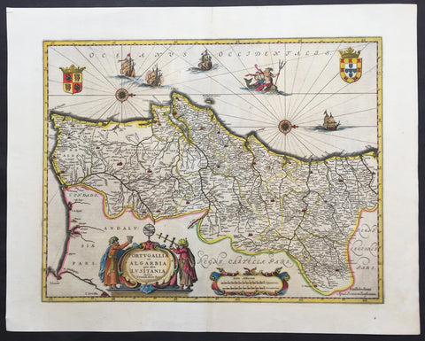
1646 Jan Jansson Large, Old Antique Map of Portugal - Portugallia et Algarbia
- Title : Portugallia et Algarbia quae olim Lusitania
- Date : 1646
- Condition: (A+) Fine Condition
- Ref: 81055
- Size: 24in x 19in (610mm x 480mm)
Description:
This finely engraved beautifully hand coloured original antique map of Portugal was published by Jan Jansson in the 1646 Latin edition of Atlas Novus. (Ref Tooley M&B)
General Description:
Paper thickness and quality: - Heavy and stable
Paper color: - off white
Age of map color: - Original
Colors used: - Green, red, orange, yellow, blue
General color appearance: - Authentic
Paper size: - 24in x 19in (610mm x 480mm)
Plate size: - 20in x 15in (535mm x 385mm)
Margins: - Min 1in (25mm)
Imperfections:
Margins: - None
Plate area: - None
Verso: - None
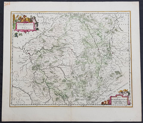
1646 Jan Jansson Antique Map Historic regions Champagne & Brie Northern France
- Title : Champaigne et Brie etc
- Ref #: 50229
- Size: 22 1/2in x 20in (570mm x 505mm)
- Date : 1646
- Condition: (A+) Fine Condition
Description:
This beautifully hand coloured original copper-plate engraved antique map of the historic regions of Champagne & Brie in northern France, centering on the city of Rheims by Jan Jansson - after Nicolas Sanson - was published in the 1646 Latin edition of Mercators Atlas by Jan Jansson and Henricus Hondius. (Ref: Tooley, Koeman)
General Definitions:
Paper thickness and quality: - Heavy and stable
Paper color : - off white
Age of map color: - Original
Colors used: - Yellow, green, blue, pink
General color appearance: - Authentic
Paper size: - 22 1/2in x 20in (570mm x 505mm)
Plate size: - 20in x 16in (510mm x 405mm)
Margins: - Min 1in (25mm)
Imperfections:
Margins: - None
Plate area: - None
Verso: - None
Background:
Champagne is a historical province in the northeast of France, now best known as the Champagne wine region for the sparkling white wine that bears its name. It was founded in 1065 near the city of Provins and was made up of different counties descended from the early medieval kingdom of Austrasia.
Brie is a historic region of northern France. It was once divided into three sections ruled by different feudal lords: the western Brie française, corresponding roughly to the modern department of Seine-et-Marne in the Île-de-France region; the eastern Brie champenoise, forming a portion of the modern department of Marne in the historic region of Champagne (part of modern-day Grand Est); and the northern Brie pouilleuse, forming part of the modern department of Aisne in Picardy.
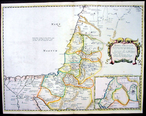
1650 Nicolas Sanson Antique Map of The Holy Lands, Canaan
- Title : Terra Chanaan..
- Ref #: 40679
- Size: 22 1/2in x 17 1/2in (570mm x 445mm)
- Date : 1650
- Condition: (A) Very Good Condition
Description:
This beautifully hand coloured original antique map of the Holy Land and the Land of Canaan was engraved by Jon Somer and was published by Nicholas Sanson in the 1650 edition ofCartes Generales de Toutes les Parties du Monde.
Canaan is an ancient term for a region encompassing modern-day Israel, Lebanon, the Palestinian territories and adjoining coastal lands, including parts of Jordan, Syria and northeastern Egypt. In the Hebrew Bible, the "Land of Canaan" extends from Lebanon southward across Gaza to the "Brook of Egypt" and eastward to the Jordan River Valley. In far ancient times, the southern area included various ethnic groups. The Amarna Letters found in Ancient Egypt mention Canaan (Akkadian: Kinaḫḫu) in connection with Gaza and other cities along the Phoenician coast and into Upper Galilee. Many earlier Egyptian sources also mention numerous military campaigns conducted in Ka-na-na, just inside Asia. (Ref:Tooley; Koeman)
General Description:
Paper thickness and quality: - Heavy and stable
Paper color: - White
Age of map color: - Original & later color
Colors used: - Yellow, green, pink
General color appearance: - Authentic
Paper size: - 22 1/2in x 17 1/2in (570mm x 445mm)
Plate size: - 22in x 16 1/2in (560mm x 420mm)
Margins: - Min 1/4in (6mm)
Imperfections:
Margins: - None
Plate area: - Worm holes repair to top & bottom centrefold
Verso: - None
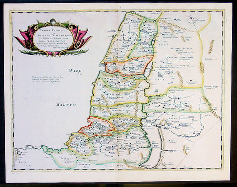
1650 Sanson Large Antique Map of the Holy Land - 12 Tribes of Israel
- Title : Terra Promissa in Sortes seu Tribus XII...Auctore de la Rue
- Ref #: 40680
- Size: 22 1/2in x 17 1/2in (570mm x 445mm)
- Date : 1650
- Condition: (A) Very Good Condition
Description:
This beautifully hand coloured originalantique map of the Promised Land divided into the 12 tribes by Philippe De la Rue was engraved by John Somer and was published by Nicholas Sanson in the 1650 edition ofCartes Generales de Toutes les Parties du Monde. (Ref:Tooley; Koeman)
General Description:
Paper thickness and quality: - Heavy and stable
Paper color: - White
Age of map color: - Original color
Colors used: - Yellow, green, pink
General color appearance: - Authentic
Paper size: - 22 1/2in x 17 1/2in (570mm x 445mm)
Plate size: - 21in x 16in (535mm x 410m)
Margins: - Min 1/2in (12mm)
Imperfections:
Margins: - None
Plate area: - Small worm holes repaired along top centerfold
Verso: - None
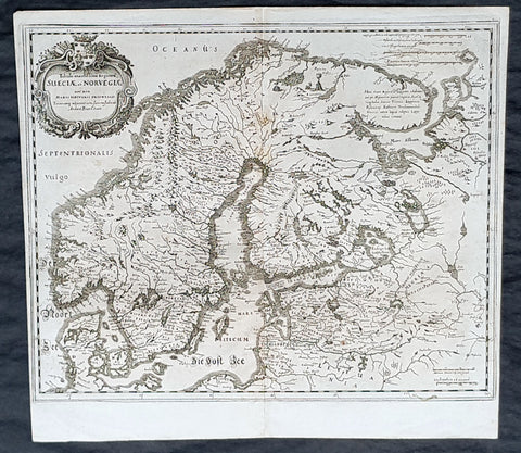
1653 Matthaus Merian Antique Map of Scandinavia Norway, Sweden, Denmark, Finland
- Title : Tabula exantissima Reguora Sueciae et Norvegiae...Andcea Buze o Sueco
- Date : 1635
- Condition: (A+) Fine Condition
- Ref: 35504
- Size: 14 1/4in x 13 1/4in (360mm x 335mm)
Description:
This fine original copper-plate engraved antique map of Scandinavia, Norway, Sweden, Denmark, Finland & Baltic States by Matthaus Merian was published in Theatrum Europaeum in 1635.
General Definitions:
Paper thickness and quality: - Heavy and stable
Paper color : - off white
Age of map color: -
Colors used: -
General color appearance: -
Paper size: - 14 1/4in x 13 1/4in (360mm x 335mm)
Plate size: - 14in x 13in (355mm x 325mm)
Margins: - Min 1/4in (5mm)
Imperfections:
Margins: - None
Plate area: - None
Verso: - None
Background:
Before the fifteenth century the people of Southern Europe had little geographical knowledge of the Scandinavian World except from sketchy detail shown in the Catalan Atlas (1375) and on a number of \\\" portolani\\\" embracing Denmark and the southern tip of Norway. It was not until 1427 that a manuscript map prepared about that time by Claudius Clavus (b.1388) a Dane who spent some time in Rome, made available to scholars a tolerable outline of the northern countries and Greenland. That was to remain the best map available for the rest of the century and it was used as the basis for maps of Scandinavia in early printed editions of Ptolemy. Others by Nicolaus Cusanus (1491) and Ehrhard Etzlaub (c. 1492) followed but, needless to say, these are extremely rare; even the later maps by Olaus Magnus and Marcus Jordan, where they have survived at all , are known only by a very few examples. In fact, apart from the rare appearance of an early Ptolemy map, the oldest of Scandinavia which a collector is likely to find are those of Munster\\\'s Cosmograhy first published in 1544. In the following centuries the few maps and charts complied in Scandinavia were usually published in Amsterdam, Antwerp, Paris or Nuremberg, the most important maps often being incorporated in the major Dutch, French & German Atlases. (Ref: Tooley; M&B)
Merian, Matthaus 1593 - 1650
Merian was a Swiss-born engraver who worked in Frankfurt for most of his career, where he also ran a publishing house. He was a member of the patrician Basel Merian family.
Born in Basel, Merian learned the art of copperplate engraving in Zürich. He next worked and studied in Strasbourg, Nancy, and Paris, before returning to Basel in 1615. The following year he moved to Frankfurt, Germany where he worked for the publisher Johann Theodor de Bry, who was the son of renowned engraver and traveler Theodor de Bry.
In 1617, Merian married Maria Magdalena de Bry, daughter of the publisher, and was for a time associated with the de Bry publishing house. In 1620 they moved back to Basel, but three years later returned to Frankfurt. They had four daughters and three sons, including Matthäus Merian the Younger. Maria Magdalena de Bry died in 1645 and the following year Matthäus married Johanna Catharina Hein. Five years later, Matthäus died, leaving his wife with two small children, Anna Maria Sibylla Merian (born 1647) who later became a pioneering naturalist and illustrator and a son, Maximilian, who died before his third birthday.
In 1623 Merian took over the publishing house of his father-in-law after de Brys death. In 1626 he became a citizen of Frankfurt and could henceforth work as an independent publisher. He spent most of his working life in Frankfurt.
Early in his life, he had created detailed town plans in his unique style, e.g. a plan of Basel (1615) and a plan of Paris (1615). With Martin Zeiler (1589 - 1661), a German geographer, and later (circa 1640) with his own son, Matthäus Merian (der Jüngere, i.e.the Younger or Jr.) (1621 - 1687), he produced a series of Topographia. The 21-volume set was collectively known as the Topographia Germaniae. It includes numerous town plans and views, as well as maps of most countries and a World Map—it was such a popular work that it was re-issued in many editions. He also took over and completed the later parts and editions of the Grand Voyages and Petits Voyages, originally started by de Bry in 1590.
Merians work inspired the Suecia Antiqua et Hodierna by Erik Dahlberg. The German travel magazine Merian is named after him.
He was also noted for the finesse of his alchemical illustrations, in books such as the Musaeum Hermeticum (1678) and Atalanta Fugiens (1618).
Matthäus Merian died after several years of illness in 1650 in Langenschwalbach, near Wiesbaden.
After his death, his sons Matthäus Jr. and Caspar took over the publishing house. They continued publishing the Topographia Germaniae and the Theatrum Europaeum under the name Merian Erben (i.e. Merian Heirs).
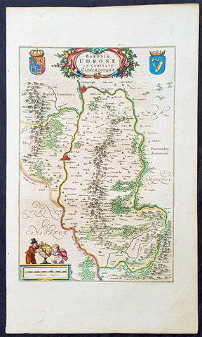
1658 Joan Blaeu Antique Map of The Barony of Idrone, County Carlow, SE Ireland
- Title : Baronia Udrone in Comitatu Cathergoughe
- Ref #: 70161
- Size: 21in x 12 1/2in (535mm x 320mm)
- Date : 1658
- Condition: (A+) Fine Condition
Description:
This beautifully hand coloured original copper-plate engraved antique map of the ancient Barony of Idrone (Udrone) located mainly in County Carlow on the Barrow River, SE Ireland, was published in the 1658 Spanish edition of Joan Blaeus Atlas Novus of Great Britain & Ireland.
This map is centered around the River Barrow with the city of Carlow (Catherlagh) to the north Leighlinbridge (Laghlyn) to the center.
General Definitions:
Paper thickness and quality: - Heavy and stable
Paper color : - off white
Age of map color: -
Colors used: -
General color appearance: -
Paper size: - 21in x 12 1/2in (535mm x 320mm)
Plate size: - 15 1/2in x 10in (395mm x 255mm)
Margins: - Min 1in (25mm)
Imperfections:
Margins: - None
Plate area: - None
Verso: - None
Background:
Idrone (Udrone) is a barony in County Carlow, Republic of Ireland, centering on the River Barrow. The early barony of Idrone was split into East and West in 1799.
Idrone takes its name from the ancient name for the tuath, first recorded c. 1100 as Hua Drona in the Latin Vitae sanctorum Hiberniae. The Martyrology of Oengus the Culdee (c. 1150) calls it Huib Dróna in Middle Irish. The ruling family claimed descent from Drona, fourth son of Cathair Mór, a legendary 2nd century AD king.
The Uí Bairrche and Ui Drona are cited early here. The O\'Riain (Ryan) sept was Lords of Idrone. The Ó Dubhghaill (O\'Doyle) clan of Viking origin was said to originate from a 9th-century King of Idrone.
Blaeus fifth map of Ireland seems a strangely remote choice of location for the great cartographer to have singled out for special treatment. For the reasons why this map was engraved in the first place one must go back to power-struggles between the leading Anglo-Irish families in Elizabethan Ireland.
The Butlers wars of the 1560s and 1570s were the struggles between the Fitzgeralds (Earls of Desmond) and the Butlers (Earls of Ormonde) who fought what is thought to have been the last privately pitched battle in the British Isles at Affane in Waterford in 1565.
As if matters were not complicated and volatile enough an English adventurer called Sir Peter Carew (1514-75) arrived on the scene. Carew was a man with a fascinatingly chequered career (he was imprisoned in the Tower of London and later Constable of it!), whose claims to the Barony of Idrone were upheld at Dublin Castle, the seat of English power in Ireland. He also claimed ancient title to half of Cork and found himself at war with both Desmond and Butler. These events seem to have caught Mercators - the original publisher of this map - attention in Antwerp and this detailed map of a small corner of Ireland was engraved and included fin most 16th & 17th century sets of Irish maps. (Ref: Koeman; Tooley; M&B)
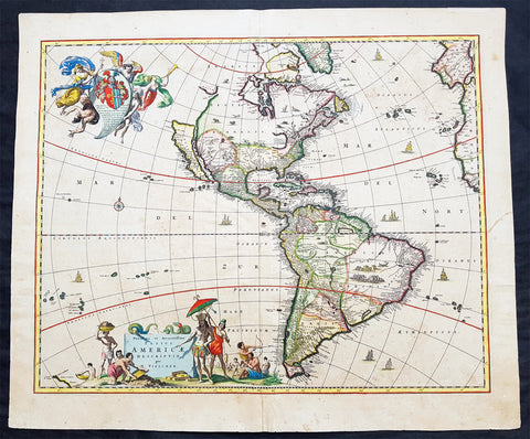
1658 Visscher Large Antique Map of America
- Title : Novissima et Accuratissima Totius Americae Descriptio per N. Visscher
- Ref #: 50683
- Size: 24in x 20 1/4in (610mm x 515mm)
- Date : 1658
- Condition: (A) Very Good Condition
Description:
This large rare beautifully hand coloured original antique 1st edition map of America was published by Nicholas Visscher in ca 1658.
This is an important map, derived from Blaeu's earlier wall map, that would prove influential to many future maps of the western hemisphere, with similar maps issued by De Wit, Danckerts, Allard, and Ottens to the end of the 17th century.
Background:
Various dates have been attributed to this map from 1658 to 1680. The earliest date derives from its presence in the third volume of Jan Jansson's Novus Atlas dated 1658. However, it is not present in all examples and other maps have borne dates as late as 1680. The heirs of Jan Jansson who died in 1664, appear to have issued the volumes with old title pages on a continuous basis.
Although the map did not provide much in the way of cartographic advances after Blaeu, it had a large influence on future cartographers drawing upon either its geography or the distinctive cartouches. One of the most recognisable features is the large open lake in the place of the western Great Lakes. The single lake to its east most probably represents that of Ontario, but is named Lac Contenant. This like much of the map is derived from Joan Blaeu's wall map of the world, 1648. The use of Real de Nueva Mogulcorrectly placed on the east bank of the Rio del Norte is taken directly from Blaeu. One are where Visscher breaks from this is his depiction of the west coast. He uses an older model, that of Briggs, 1625 although with a broader north coast to California as an Island, a feature that was not found in any of Viscchers earlier works. He continues the mainland coastline north-north -east towards the Strait of Anian, which separates it from ANIAN.
The title is decorated with a scene showing the panning of gold or silver, with a native standing by under an umbrella. The cartouche top left bears a dedication to Cornelis Witsen, mayor of Amsterdam who financed many trips to the New World and depicts three angels helping a native Indian to heaven while the devil is fading away. (Burden; M&B; Tooley)
General Description:
Paper thickness and quality: - Heavy and stable
Paper color: - off white
Age of map color: - Original
Colors used: - Red, yellow, green, blue
General color appearance: - Authentic
Paper size: - 24in x 20 1/4in (610mm x 515mm)
Plate size: - 21 1/2in x 17 1/4in (545mm x 440mm)
Margins: - Min 1in (25mm)
Imperfections:
Margins: - Uniform age toning
Plate area: - Uniform age toning, center-fold re-joined, no loss
Verso: - Uniform age toning, light spotting
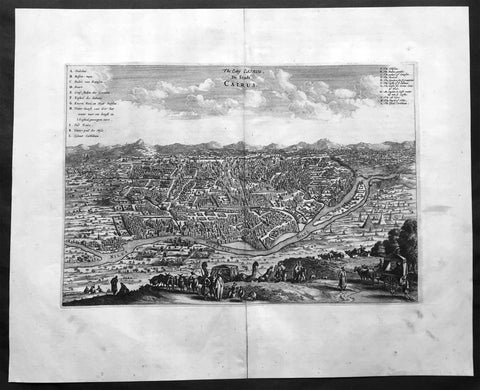
1670 Dapper & Ogilby Large Old, Antique Print View of Cairo, Egypt
- Title : De Stadt Cairus : De Stadt Cairus
- Ref #: 40367
- Size: 17 1/2in x 14in (445mm x 355mm)
- Date : 1670
- Condition: (A+) Fine Condition
Description:
This finely engraved original antique print a view of the Egyptian city of Cairo was published by John Ogilby in the 1670 edition of An Accurate Description and Complete History of America and Africa based on De Nieuwe en Onbekende Wereld by Olfert Dapper.
Background: A fine bird's-eye view of the ancient city of Cairo, originally featured in Dapper's 'Description of Africa', and heavily based upon the 1549 view of Cairo by Venetian printmaker Matteo Pagono. This striking view of Cairo places the dense city in the centre, surrounded by open landscape. Set to the right of the city, past the River Nile, are depictions of the Pyramids and the Sphinx. In the immediate foreground, several travellers can be seen upon a hilltop that overlooks the city. With them are various animals, including cattle and camels. Two lettered keys are featured, one in Dutch in the upper left corner, and the other, an English translation in the upper right.
The view was featured in John Ogilby's English edition of Olfert Dapper's 'Description of Africa'.
Olfert Dapper's 'Description of Africa' was an ethnographic book which offered a detailed description of the parts of Africa known to Europeans in the mid-seventeenth century. Despite the work being regarded as one of the most important and detailed seventeenth-century publications on Africa, Dapper himself never actually visited the continent. Instead, he relied on the reports of Jesuit missionaries and Dutch explorers.
Dapper's 'Description of Africa' was first published in 1668 by Jacob van Meurs in Amsterdam, with a second Dutch edition appearing in 1676. In 1670, a German translation of the publication was issued, and in the same year, an English translation, which is generally attributed to John Ogilby. A French edition was published in 1676, although it was not as true to the original as the other translations.
Olfert Dapper (1636 - 1689) was a Dutch physician and writer. Despite never travelling outside of the Netherlands, Dapper was a writer of world history and geography.
John Ogilby (1600-1676) was a Scottish cartographer and publisher. Ogilby is perhaps best known for his series of road-maps entitled the "Britannia", which was the first road-atlas of any country, published in 1675. (Ref: Tooley, M&B)
General Description:
Paper thickness and quality: - Heavy and stable
Paper color: - off white
Age of map color: -
Colors used: -
General color appearance: -
Paper size: - 17 1/2in x 14in (445mm x 355mm)
Plate size: - 13 1/2in x 9 1/2in (345mm x 245mm)
Margins: - Min 2in (50mm)
Imperfections:
Margins: - Slight separation to bottom margin centrefold, not affecting the image
Plate area: - None
Verso: - None
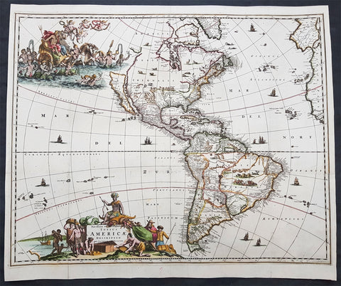
1671 Jacob Van Meurs Rare Original Antique Map of America - Island of California
- Title : Novissima et Accuratissima Totius Americae Descriptio per Jacobum Meursium
- Date : 1671
- Size: 22in x 19in (560mm x 485mm)
- Ref #: 61157
- Condition: (A) Very Good Condition
Description: This uncommon and rare original antique map of America and the Pacific, including parts of New Zealand, was published in Amsterdam by Jacob Van Meurs in 1671 for the German edition of Arnold Montanus' ground breaking publication "America". (Ref: Burden, Tooley, Koeman)
General Description:
Paper thickness and quality: - Heavy and stable
Paper color: - off white
Age of map color: - Early
Colors used: - Green, red, orange, yellow, blue
General color appearance: - Authentic
Paper size: - 22in x 19in (560mm x 485mm)
Plate size: - 21 3/4in x 17 1/2in (550mm x 445mm)
Margins: - Min 1/2in (12mm)
Imperfections:
Margins: - Light soiling
Plate area: - Folds as issued, light separation along folds, no loss
Verso: - Professionally backed onto Japanese archival rice paper
Background: Unlike the Dutch edition of this map (by Van Schaegen) and English edition (by John Ogilby), which copied the De Wit / Visscher America map, Van Meurs creates a highly decorative new plate for the German edition of Montanus' America. The plate was later acquired by Pierre Vander Aa and re-issued bearing Vander Aa's name circa 1714.
The map shows California as an Island on the first Sanson Projection, showing a single large Great Lake (open at the west), a curious north-easterly coastline north of the Island of California and a geographically misaligned South America, with tribal vignettes in Brazil and wild life in North America. The map predates La Salle's information on the interior of North America, but includes excellent detail on Canada and the East Coast of North America, noting the Dutch Possessions, the Iroquois regions, N. Anglia, New Amsterdam, the Cheaspeak, Plymouth, and many Indian Place names.
Meurs's map is based upon Nicholas Visscher's map of 1658, in that it includes the coastline New Zealand and the early Sanson model for California, and only shows one of the Great Lakes, updated from Visscher's edition. Visscher in turn drew his information from Joan Blaeu's wall map of the World, published in 1648.
The map is most notable for its elaborate allegorical cartouches. One of the most outstanding features of this map are the beautifully engraved decorative cartouches that include numerous vignettes of wildlife, American Indians, sailing ships and battles. The title is surrounded by Native Americans trading with Europeans and in the North Pacific is a lavish scene of Neptune and his consort in a chariot surrounded by his entourage and putti. The map was to be included in Montanus book of America and so has folds as issued. (Ref: Burden, Tooley, Koeman)
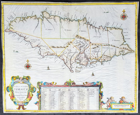
1671 John Ogilby 1st Antique English map of The Island of Jamaica, Caribbean
- Title : Novissima et Acccuratissima Jamaicae Descriptio per Johannem Ogiluium Cosmographum Regnum 1671
- Size: 21 1/4in x 17 1/4in (515mm x 440mm)
- Condition: (B) Good Condition
- Date : 1671
- Ref #: 82081
Description:
This beautifully hand coloured original copper-plate engraved antique map of the Caribbean Island of Jamaica - the first English map of the Island - by John Ogilby was engraved by Francis Lamb (active 1665 - 1700) in 1671 - dated - and published in the atlas America: Being The latest, And Most Accurate Description Of The New World; Containing The Original of the Inhabitants, and the Remarkable Voyages thither. The Conquest Of The Vast Empires Of Mexico and Peru, and Other Large Provinces and Territories, With The Several European Plantations In Those Parts. Also Their Cities, Fortresses, Towns, Temples, Mountains, and Rivers
This map has undergone some restoration, as with most of the folded maps from Ogilbys America, mainly to the borders and is reflected in the price. Please see further details below.
This is the earliest detailed English maps of Jamaica. It had a significant influence on subsequent maps and is based on surveys by John Man, Jamaicas surveyor general. Ogilbys map divides the island into named precincts and notes major cities and plantations. A large inset below lists the plantations and indicates whether they produce cocoa, indigo, sugar and/or cotton. On either side is a decorative title cartouche and a mileage cartouche adorned with putti. This is one of the few original maps from Ogilbys America.
General Definitions:
Paper thickness and quality: - Heavy and stable
Paper color : - off white
Age of map color: - Original
Colors used: - Yellow, green, blue, pink
General color appearance: - Authentic
Paper size: - 21 1/4in x 17 1/4in (515mm x 440mm)
Plate size: - 21 1/4in x 17 1/4in (515mm x 440mm)
Margins: - Min 0in (0mm)
Imperfections:
Margins: - All margins cropped to plate-marks. Right border restored, part of the bottom left & bottom center border restored.
Plate area: - Light creasing, re-enforced along original folds
Verso: - Re-enforced along original folds, soiling
Background:
Jamaica is an island country situated in the Caribbean Sea. Previously inhabited by the indigenous Arawak and Taíno peoples, the island came under Spanish rule following the arrival of Christopher Columbus in 1494. Many of the indigenous people died of disease, and the Spanish transplanted African slaves to Jamaica as labourers. The island remained a possession of Spain until 1655, when England conquered it and renamed it Jamaica. Under British colonial rule Jamaica became a leading sugar exporter, with its plantation economy highly dependent on African slaves. The British fully emancipated all slaves in 1838, and many freedmen chose to have subsistence farms rather than to work on plantations. Beginning in the 1840s, the British utilized Chinese and Indian indentured labour to work on plantations.
Spanish Town has the oldest cathedral of the British colonies in the Caribbean. The Spanish were forcibly evicted by the English at Ocho Rios in St. Ann. In the 1655 Invasion of Jamaica, the English, led by Sir William Penn and General Robert Venables, took over the last Spanish fort on the island. The name of Montego Bay, the capital of the parish of St. James, was derived from the Spanish name manteca bahía (or Bay of Lard), alluding to the lard-making industry based on processing the numerous boars in the area.
In 1660, the population of Jamaica was about 4,500 white and 1,500 black. By the early 1670s, as the English developed sugar cane plantations and imported more slaves, black people formed a majority of the population. The colony was shaken and almost destroyed by the 1692 Jamaica earthquake.
The Irish in Jamaica also formed a large part of the islands early population, making up two-thirds of the white population on the island in the late 17th century, twice that of the English population. They were brought in as indentured labourers and soldiers after the conquest of Jamaica by Cromwells forces in 1655. The majority of Irish were transported by force as political prisoners of war from Ireland as a result of the ongoing Wars of the Three Kingdoms at the time. Migration of large numbers of Irish to the island continued into the 18th century.
Jews were expelled from Spain in 1492 and then forcibly converted to Christianity in Portugal, during a period of persecution by the Inquisition. Some Spanish and Portuguese Jewish refugees went to the Netherlands and England, and from there to Jamaica. Others were part of the Iberian colonisation of the New World, after overtly converting to Catholicism, as only Catholics were allowed in the Spanish colonies. By 1660, Jamaica had become a refuge for Jews in the New World, also attracting those who had been expelled from Spain and Portugal.
An early group of Jews arrived in 1510, soon after the son of Christopher Columbus settled on the island. Primarily working as merchants and traders, the Jewish community was forced to live a clandestine life, calling themselves Portugals. After the British took over rule of Jamaica, the Jews decided the best defense against Spains regaining control was to encourage making the colony a base for Caribbean pirates. With the pirates installed in Port Royal, which became the largest city in the Caribbean, the Spanish would be deterred from attacking. The British leaders agreed with the viability of this strategy to forestall outside aggression.
When the English captured Jamaica in 1655, the Spanish colonists fled after freeing their slaves. The slaves dispersed into the mountains, joining the maroons, those who had previously escaped to live with the Taíno native people. During the centuries of slavery, Maroons established free communities in the mountainous interior of Jamaica, where they maintained their freedom and independence for generations. The Jamaican Maroons fought the British during the 18th century. Under treaties of 1738 and 1739, the British agreed to stop trying to round them up in exchange for their leaving the colonial settlements alone, but serving if needed for military actions. Some of the communities were broken up and the British deported Maroons to Nova Scotia and, later, Sierra Leone. The name is still used today by modern Maroon descendants, who have certain rights and autonomy at the community of Accompong.
During its first 200 years of British rule, Jamaica became one of the worlds leading sugar-exporting, slave-dependent colonies, producing more than 77,000 tons of sugar annually between 1820 and 1824. After the abolition of the international slave trade in 1807, the British began to import indentured servants to supplement the labour pool, as many freedmen resisted working on the plantations. Workers recruited from India began arriving in 1845, Chinese workers in 1854.
Ogilby, John 1600-1676
Ogilby was a Scottish cartographer and publisher. Ogilby is perhaps best known for his series of road-maps entitled the Britannia, which was the first road-atlas of any country, published in 1675.
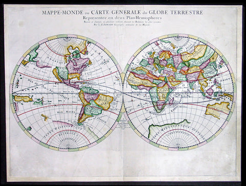
1678 Sanson Large Antique Twin Hemisphere World Map
- Title : Mappe-Monde ou Carte Generale du Globe Terrestre Represntee en Duex Plan Hemispheres...1678
- Date : 1678
- Condition: (A) Very Good Condition
- Ref: 35022
- Size: 23 1/2in x 17 1/2in (600mm x 445mm)
Description:
This large beautifully hand coloured originalantique Twin Hemisphere World Map was engraved by Pierre Mariette and published by Guillaume Sanson in 1678 - dated.
This elegant map is a progression of Nicolas Sanson's Twin Hemisphere World map of 1651. Nicolas drew this map for his 1660 atlas, and after his death in 1667, his sons Guillaume and Adrien used it in their atlases of 1669 and 1678.
This edition shows Australia with more definition, this along with Tasmania's coast and a small portion of New Zealand's coastline.
Background:
This map is the first to indicate N. Danemarckwest of the Hudson Bay, here named Mer Christiane. California is shown as an island, and Acoma and Santa Fe are noted in the Southwest, with Acoma shown correctly atop a mesa. The coastline of Asia is shown with the discoveries of the De Vries noted, including Terre de Iesso or Ieco, and a land called Yupi. The Great Lakes are not updated from the 1651 version, and do not show all five lakes. The map is typical of Sanson's "scientific" style of cartography with no decorative elements.
It was published in conjunction with Pierre Mariette (father and son), who published many of Sanson's works after 1645. (Ref: Shirley; Tooley; Koeman)
General Description:
Paper thickness and quality: - Heavy and stable
Paper color: - White
Age of map color: - Early
Colors used: - Yellow, green, pink
General color appearance: - Authentic
Paper size: - 23 1/2in x 17 1/2in (600mm x 445mm)
Plate size: - 23 1/2in x 15 1/2in (600mm x 395mm)
Margins: - Min 1/2in (12mm)
Imperfections:
Margins: - Light soiling
Plate area: - Light soiling, professional repair to & adjacent to centerfold
Verso: - None
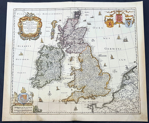
1690 Nicolas Visscher Antique Map of Great Britain & Ireland
- Title : Magnae Britanniae Tabula Angliam, Scotiam, et Hiberniam Continens in Lucem Edita Fer Nicolaum Visscher
- Size: 23in x 19 1/2in (585mm x 490mm)
- Condition: (A) Very Good Condition
- Date : 1690
- Ref #: 93002
Description:
This large original hand coloured copper-plate engraved antique map of Great Britain & Ireland was published by Nicholas Visscher II in 1690.
General Definitions:
Paper thickness and quality: - Heavy and stable
Paper color : - off white
Age of map color: - Original
Colors used: - Yellow, green, blue, pink
General color appearance: - Authentic
Paper size: - 23in x 19 1/2in (585mm x 490mm)
Plate size: - 21in x 18 1/2in (535mm x 485mm)
Margins: - Min 1/2in (12mm)
Imperfections:
Margins: - Small bottom left section of margin into scale restored
Plate area: - Light age toning
Verso: - Age toning
Background:
In 1558 Queen Elizabeth came to the throne in the midst of a fast changing world. In 1563 a nineteen sheet map, copies of which survive only in manuscript form, was completed by Laurence Nowell, and no doubt, the issue of Mercator\'s large-scale map of the British Isles in 1564 had an important influence on the thought of the period. A few years later a national survey was commissioned privately, although probably at the instigation of Lord Burghley, the Lord Treasurer, but subsequently was completed with royal encouragement. The outcome was Christopher Saxton\'s Atlas of EngIand and Wales, started about 1570 and published in 1579 - the first printed set of county maps and the first countrywide atlas on such a splendid scale produced anywhere. A Welsh antiquarian, Humphrey Lhuyd completed a set of surveys that were even more successful than Saxton in which he had produced fine manuscript maps of England and Wales which were used by Ortelius in editions of his Atlas from 1573 onwards.
The earliest maps of the 17th century, attributed to William Smith of the College of Heralds, covered only twelve counties based on Saxton/Norden and were presumably intended to be part of a complete new atlas. They were printed in the Low Countries in 1602-3 and were soon followed by maps for the Latin edition of Camden\'s Britannia dated 1607. In 1610-11 the first edition of John Speed\'s famous county Atlas The Theatre of the Empire of Great Britaine was published and immediately replaced Saxton\'s in popular appeal. Although Speed assembled much of his material from the earlier works of Saxton, Norden and others, a considerable part of the up-to-date information, especially relating to the inset town plans depicted on his maps, was obtained first hand. The maps undoubtedly owed much of their popularity to the splendid engravings of high quality made in the workshops in Amsterdam of Jodocus Hondius to whom Speed sent his manuscripts, the plates subsequently being returned to London for printing.
In 1645, Volume IV of the famous Blaeu World Atlas covering the counties of England and Wales was published in Amsterdam. These maps have always been esteemed as superb examples of engraving and design, the calligraphy being particularly splendid, but nevertheless they were nearly all based on Saxton and Speed and added little to geographical knowledge.
Not until the latter part of the century do we find an English map maker of originality with the capacity to put new ideas into practice. John Ogilby, one of the more colourful figures associated with cartography, started life as a dancing master and finished as King\'s Cosmographer and Geographic Printer. After publishing a small number of county maps, somewhat on the lines of John Norden he issued in 1675 the Britannia, the first practical series of detailed maps of the post roads of England and Wales on a standard scale of 1,760 yards to the mile. Up to the end of the century and beyond, reprints and revisions of Saxton\'s and Speed\'s atlases continued to appear and the only other noteworthy county maps were Richard Blome\'s Britannia (1673), John Overton\'s Atlas (c. 1670) and Robert Morden\'s maps for an English translation of Camden\'s Britannia published in 1695.
Another noted cartographer of the day was Captain Greenvile Collins, and of his work in surveying the coasts of Great Britain culminating in the issue in 1693 of the Great Britain\'s Coasting Pilot. Apart from these charts, English cartographers published during the century a number of world atlases. Speed was the first Englishman to produce a world atlas with the issue in 1627 of his A Prospect of the Most Famous Parts of the World. Other atlases appeared later in the century by Peter Heylin, John Seller, William Berry, Moses Pitt and Richard Blome, whilst Ogilby found time to issue maps of Africa, America and Asia. Far more important, from the purely scientific point of view, was the work of Edmund Halley, Astronomer Royal, who compiled and issued meteorological and magnetic charts in 1688 and 1701 respectively.
At the beginning of the eighteenth century the Dutch map trade was finally in decline, the French in the ascendant and the English to a great extent still dominated by Saxton and Speed except, as we have shown, in the spheres of sea charts and road maps. There were atlases by John Senex, the Bowles family, Emanuel and Thomas Bowen, Thomas Badeslade and the unique bird\'s-eye perspective views of the counties, The British Monarchy by George Bickham. In 1750-60 Bowen and Kitchin\'s The Large English Atlas containing maps on a rather larger scale than hitherto was published.
In 1759 the Society for the encouragement of Arts, Manufactures and Commerce offered an award of £100 for the best original surveys on this scale and by the end of the century about thirty counties had been re-surveyed. These maps, many of which formed, in later years, the basis for the first issues of county maps by the Ordnance Survey Office were not only decorative but a tremendous improvement geographically on earlier local maps. As a consequence, the skills and expertise of the new-style cartographers soon enabled them to cover the world as well as the domestic market. Thomas Jefferys was such a man; he was responsible for a number of the new 1 in. to 1 mile county surveys and he issued an edition of Saxton\'s much battered 200-year-old plates of the county maps, but he is better known for many fine maps of North America and the West Indies. His work was continued on the same lines by William Faden, trading as Faden and Jefferys. Other publishers such as Sayer and Bennett and their successors Laurie and Whittle published a prodigious range of maps, charts and atlases in the second half of the century. A major influence at this time was John Cary who, apart from organizing the first re-survey of post roads since Ogilby and subsequently printing the noted Travellers\' Companion, was a prolific publisher of atlases and maps of every kind of all parts of the world. After starting work with Cary, and taking part in the new road survey, Aaron Arrowsmith set up in his own business and went on to issue splendid large-scale maps of many parts of the world. Both Cary\'s and Arrowsmith\'s plates were used by other publishers until far into the next century and, in turn, their work was taken up and developed by James Wyld (Elder and Younger) and Tallis and Co.
Later into the 19th century some of the better known cartographers and publishers were by Henry Teesdale (1829-30), Christopher and John Greenwood, surveyors, Thomas Moule, a writer on heraldry and antiques (1830-36) and John Walker (1837) but by about the middle of the century few small-scale publishers survived and their business passed into the hands of large commercial concerns such as Bartholomews of Edinburgh and Philips of London who continue to this day. (Ref: Shirley; Tooley; M&B)
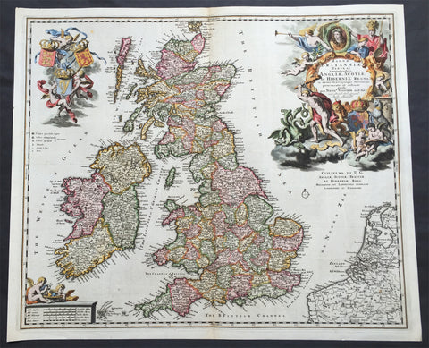
1690 Nicolas Visscher Large Old, Antique Map of Great Britain & Ireland
- Title : Magnae Britanniae Tabula...Angliae, Scotiae, Ac Hiberniae Regna...Per Nicol. Visscher...Guilielmo III D.G.
- Ref #: 61110
- Size: 24in x 20in (610mm x 515mm)
- Date : 1690
- Condition: (A+) Fine Condition
Description: This large rare beautifully hand coloured original antique map of Great Britain & Ireland was published by Nicholas Visscher in 1690
This is a very beautiful map with rich deep colour and heavy engraving on clean and stable paper. It is also an important map, dedicated to William III of Orange (King Billy) who ruled GB & Ireland between 1689 & 1702, a time of great change both in Europe and the New World.
Background: In 1558 Queen Elizabeth came to the throne in the midst of a fast changing world. In 1563 a nineteen sheet map, copies of which survive only in manuscript form, was completed by Laurence Nowell, and no doubt, the issue of Mercator's large-scale map of the British Isles in 1564 had an important influence on the thought of the period. A few years later a national survey was commissioned privately, although probably at the instigation of Lord Burghley, the Lord Treasurer, but subsequently was completed with royal encouragement. The outcome was Christopher Saxton's Atlas of EngIand and Wales, started about 1570 and published in 1579 - the first printed set of county maps and the first countrywide atlas on such a splendid scale produced anywhere. A Welsh antiquarian, Humphrey Lhuyd completed a set of surveys that were even more successful than Saxton in which he had produced fine manuscript maps of England and Wales which were used by Ortelius in editions of his Atlas from 1573 onwards.
The earliest maps of the 17th century, attributed to William Smith of the College of Heralds, covered only twelve counties based on Saxton/Norden and were presumably intended to be part of a complete new atlas. They were printed in the Low Countries in 1602-3 and were soon followed by maps for the Latin edition of Camden's Britannia dated 1607. In 1610-11 the first edition of John Speed's famous county Atlas The Theatre of the Empire of Great Britaine was published and immediately replaced Saxton's in popular appeal. Although Speed assembled much of his material from the earlier works of Saxton, Norden and others, a considerable part of the up-to-date information, especially relating to the inset town plans depicted on his maps, was obtained first hand. The maps undoubtedly owed much of their popularity to the splendid engravings of high quality made in the workshops in Amsterdam of Jodocus Hondius to whom Speed sent his manuscripts, the plates subsequently being returned to London for printing.
In 1645, Volume IV of the famous Blaeu World Atlas covering the counties of England and Wales was published in Amsterdam. These maps have always been esteemed as superb examples of engraving and design, the calligraphy being particularly splendid, but nevertheless they were nearly all based on Saxton and Speed and added little to geographical knowledge.
Not until the latter part of the century do we find an English map maker of originality with the capacity to put new ideas into practice. John Ogilby, one of the more colourful figures associated with cartography, started life as a dancing master and finished as King's Cosmographer and Geographic Printer. After publishing a small number of county maps, somewhat on the lines of John Norden he issued in 1675 the Britannia, the first practical series of detailed maps of the post roads of England and Wales on a standard scale of 1,760 yards to the mile. Up to the end of the century and beyond, reprints and revisions of Saxton's and Speed's atlases continued to appear and the only other noteworthy county maps were Richard Blome's Britannia (1673), John Overton's Atlas (c. 1670) and Robert Morden's maps for an English translation of Camden's Britannia published in 1695.
Another noted cartographer of the day was Captain Greenvile Collins, and of his work in surveying the coasts of Great Britain culminating in the issue in 1693 of the Great Britain's Coasting Pilot. Apart from these charts, English cartographers published during the century a number of world atlases. Speed was the first Englishman to produce a world atlas with the issue in 1627 of his A Prospect of the Most Famous Parts of the World. Other atlases appeared later in the century by Peter Heylin, John Seller, William Berry, Moses Pitt and Richard Blome, whilst Ogilby found time to issue maps of Africa, America and Asia. Far more important, from the purely scientific point of view, was the work of Edmund Halley, Astronomer Royal, who compiled and issued meteorological and magnetic charts in 1688 and 1701 respectively.
At the beginning of the eighteenth century the Dutch map trade was finally in decline, the French in the ascendant and the English to a great extent still dominated by Saxton and Speed except, as we have shown, in the spheres of sea charts and road maps. There were atlases by John Senex, the Bowles family, Emanuel and Thomas Bowen, Thomas Badeslade and the unique bird's-eye perspective views of the counties, The British Monarchy by George Bickham. In 1750-60 Bowen and Kitchin's The Large English Atlas containing maps on a rather larger scale than hitherto was published.
In 1759 the Society for the encouragement of Arts, Manufactures and Commerce offered an award of £100 for the best original surveys on this scale and by the end of the century about thirty counties had been re-surveyed. These maps, many of which formed, in later years, the basis for the first issues of county maps by the Ordnance Survey Office were not only decorative but a tremendous improvement geographically on earlier local maps. As a consequence, the skills and expertise of the new-style cartographers soon enabled them to cover the world as well as the domestic market. Thomas Jefferys was such a man; he was responsible for a number of the new 1 in. to 1 mile county surveys and he issued an edition of Saxton's much battered 200-year-old plates of the county maps, but he is better known for many fine maps of North America and the West Indies. His work was continued on the same lines by William Faden, trading as Faden and Jefferys. Other publishers such as Sayer and Bennett and their successors Laurie and Whittle published a prodigious range of maps, charts and atlases in the second half of the century. A major influence at this time was John Cary who, apart from organizing the first re-survey of post roads since Ogilby and subsequently printing the noted Travellers' Companion, was a prolific publisher of atlases and maps of every kind of all parts of the world. After starting work with Cary, and taking part in the new road survey, Aaron Arrowsmith set up in his own business and went on to issue splendid large-scale maps of many parts of the world. Both Cary's and Arrowsmith's plates were used by other publishers until far into the next century and, in turn, their work was taken up and developed by James Wyld (Elder and Younger) and Tallis and Co.
Later into the 19th century some of the better known cartographers and publishers were by Henry Teesdale (1829-30), Christopher and John Greenwood, surveyors, Thomas Moule, a writer on heraldry and antiques (1830-36) and John Walker (1837) but by about the middle of the century few small-scale publishers survived and their business passed into the hands of large commercial concerns such as Bartholomews of Edinburgh and Philips of London who continue to this day. (Ref: Shirley; Tooley; M&B)
General Description:
Paper thickness and quality: - Heavy and stable
Paper color: - off white
Age of map color: - Original
Colors used: - Red, yellow, green, blue
General color appearance: - Authentic
Paper size: - 24in x 20in (610mm x 515mm)
Plate size: - 23in x 19in (585mm x 460mm)
Margins: - Min 1/2in (12mm)
Imperfections:
Margins: - None
Plate area: - None
Verso: - None
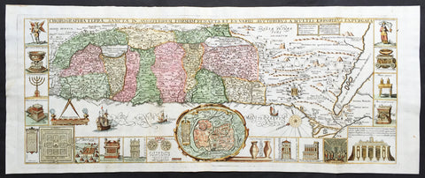
1650 Tirinus Large Antique Map of The Holy Land, Palestine, Israel
- Title : Chorographia Terrae Sanctae in angustiorem Formam Redacta, et ex variis auctoribus a multis errorbus expurgata
- Ref #: 61041
- Size: 35in x 14in (890mm x 360mm)
- Date : 1650
- Condition: (A+) Fine Condition
Description:
This large magnificent, hand coloured original antique map of the Holy Land by Johann Belling & Augustus Vindel was published in Commentarius in Sacram Scripturam (Commentary on the New and Old Testament) by the Belgian Jesuit monk Jacobus Tirinus, ca 1650.
This is without doubt one of the most visually stunning maps of the Holy land ever published and there have been many elaborated & beautiful maps of this important region published since the dark ages, when the Holy Land was considered the geographical center of the world.
Originally prepared in 1632 for Tirinus's study of the Holy Land was originallyengraved by Cornelius Galle and printed in Antwerp by Martinus Nutius. Tirinus's work went through many editions and printings that followed its original issue.
Background: Oriented to the East the map is surrounded with panels of vignettes displaying sacred objects including a menorah, the arc of the covenant, the altar of sacrifices, the Tabernacle, and a plan and elevations of the Temple. At center is an inset bird's-eye plan of ancient Jerusalem based on the Spanish biblical geographer, Juan Bautista Vilalpando. Oriented with east at top, the map includes the territories of the twelve tribes on both sides of the Jordan River and the route of the Exodus and Wandering. The map depicts from Syria and Tyre southward as far as the Sinai, Egypt and Thebes. At the southern most point, in Egypt, is located the city of Thebes and, slightly to the north, near Memphis, the wildly misshapen Pyramids of Egypt. Slightly further north is the city of Tanis, possible resting place for the Ark of the Covenant. In this spirit, slightly to the south of Tanis, the city of Ramesse is indicated as the starting point of the Biblical Exodus and the wandering of the Hebrews. Following their path into the desert and across the Red Sea – where Pharaoh is shown being inundated by the returning waters following Moses’ parting of the Red Sea. Now in the Sinai, we can follow the footsteps of the Hebrews to Mount Sinai (Sinai Mons), where Moses is drawn throwing down the tablets of God. Slightly to the northwest of this location a cleft in the mountains reveals the location of the ancient Nabatean city of Petra. With regard to Petra, the location and gorge detail is surprisingly accurate considering that it was only “discovered” by the Swiss adventurer Johannes L. Burckhardt, in 1812, 200 years after this map was drawn. Heading northward the lands claimed by the various tribes of Israel are beautifully detailed along with major cities, camps, roads, and trade routes. The Mediterranean is decorated with sailing ships and, in the lower left quadrant, a surveying tool between two censors. Surrounding the map proper on the left, right, and bottom margins, there are 19 maps and images of Biblical objects. The largest and most central of these is a stunning inset of Jerusalem, which notes the various temples and important buildings located there. Other images include the Arc of the Covenant, Israelite coins, Roman antiquities, views of a Menorah, various angels, and a plan of the Temple. All in all an extraordinary piece, one of the most attractive maps of the Holy Land ever made.
Jacobus Tirinus (1580 - 1636) or Jacobi Tirini was a Jesuit monk, theologian, historian, and Biblical scholar. His major work is the Commentarius in Sacram Scripturam a two volume Bible commentary. Tirini was born in Antwerp, Belgium in 1580. Following his admission into the Jesuit Order, Tirini became a respected Biblical scholar and a prominent member of the Order. He was assigned "First Superior" to the Antwerp Jesuit House as well as "Directior of the Holland Mission". Tirini's Biblial commentaries are still referenced today.(Ref: Laor; M&B; Tooley)
General Description:
Paper thickness and quality: - Heavy & stable
Paper color: - White
Age of map color: - Early
Colors used: - Green, blue, yellow, red, orange
General color appearance: - Authentic
Paper size: - 35in x 14in (890mm x 360mm)
Plate size: - 33in x 13in (840mm x 330mm)
Margins: - Min 1/2in (15mm)
Imperfections:
Margins: - None
Plate area: - Very light creasing in folds.
Verso: - None
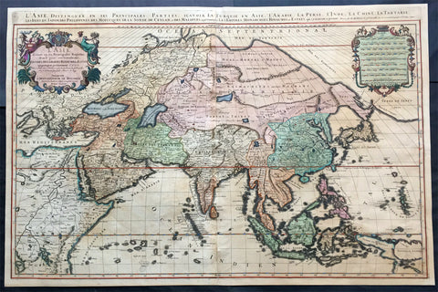
1692 Jaillot Very Large Antique Map of Asia China, SE Asia, Middle East, Russia
- Title : L' Asie divisee en ses Principales Regions....Hubert Jaillot
- Ref #: 50612
- Size: 35 1/2in x 23 1/2in (900mm x 595mm)
- Date : 1692
- Condition: (B) Good Condition
Description:
This very large, beautifully hand coloured (with gold highlights) original antique map of Asia was engraved in 1692 - dated in title - and was published by Hubert Jaillot in his monumental Atlas Nouveau.
This map is beautifully hand coloured with gold highlights along some of the country borders and the cartouches indicating it was once part of an Imperial Atlas.
The Imperial atlases were hand coloured using gold highlights and other rare colours which at the time was extremely expensive and available at the time only to royalty and the very rich.
Background: After Nicolas Sanson, Hubert Jaillot and Pierre Duval were the most important French cartographers of the seventeenth & eighteenth centuries. Jaillot, originally a sculptor, became interested in geography after his marriage to the daughter of Nicolas Berey (1606-65), a famous map colourist, and went into partnership in Paris with Sanson's sons. There, from about 1669, he undertook the re-engraving, enlarging and re-publishing of the Sanson maps in sheet form and in atlases, sparing no effort to fill the gap in the map trade left by the destruction of Blaeu's printing establishment in Amsterdam in 1672. Many of his maps were printed in Amsterdam (by Pierre Mortier) as well as in Paris. One of his most important works was a magnificent sea atlas, Le Neptune François, published in 1693 and compiled in co-operation with J D Cassini. This was re-published shortly afterwards by Pierre Mortier in Amsterdam with French, Dutch and English texts, the charts having been re-engraved. Eventually, after half a century, most of the plates were used again as the basis for a revised issue published by J N Bellin in 1753.(Ref: Tooley; M&B)
General Condition:
Paper thickness and quality: - Heavy and stable
Paper color: - off white
Age of map color: - Original
Colors used: - Yellow, green, red, brown, gold.
General color appearance: - Authentic and fresh
Paper size: - 35 1/2in x 23 1/2in (900mm x 595mm)
Plate size: - 34 1/2in x 22 1/2in (875mm x 570mm)
Margins: - Min 1/2in (10mm)
Imperfections:
Margins: - Age toning
Plate area: - Age toning, re-join to centerfold
Verso: - Age toning, several long separations to paper re-enforced with archival tape
1693 Coronelli Antique Globe Gore Part of Southern Pacific below New Zealand
- Title : Pacif
- Ref #: 31933
- Size: 11 1/2in x 10 1/2in (290mm x 270mm)
- Date : 1693
- Condition: (A+) Fine Condition
Description:
This finely engraved original hand coloured scarce approx. 1/4 sheet part Globe Gore map section - from Coronellis 42in Globe - of the very southern Pacific Ocean south of New Zealand centering on a finely engraved compass rose - was published by Vincenzo Maria Coronelli (1650 - 1718) in the 1693 Venice edition of Libro dei Globi.
(I have included a image below of the complete view of Coronellis Western Globe Gores so you can see where these gores fit the globe. The image below is an example only, from Rodney Shirleys "The Mapping of The World")
Background:
The original globe gores for the 42in Terrestial & Celestial Globes were printed on 12 full length sheets - with two polar calottes - in 1688.
To help fit into Coronellis future publications of Atlante Veneto, Libro dei Globi andIsolario dell' Atlante Veneto the gore sheets were re-issued as the same size but cut into smaller sections. This effectively allowed the gores to be published but instead of one sheet per gore there were cut into 2, 4 or 6 sections to make the one gore sheet.
The first edition of Coronelli's 3 ½-foot celestial globe was engraved by Nolin in Paris after drawings provided by the Italian geographer and was printed in 1688. At the same time, its terrestrial counterpart was engraved and printed in Venice under Coronelli's direction. These globes were produced in part as replicas of the gigantic and unique 15 foot-diameter pair of globes that Coronelli constructed and presented to Louis XIV, the King of France, in 1683, and which secured his fame as Europe's premier globe maker. In 1693, soon after Coronelli engraved and printed the first Venetian edition of the 3 ½-foot celestial globe, Nolin engraved at Paris an entirely new edition on new plates. This globe "was based on Coronelli's work, but with the main legends in Latin, not Italian, as befitted a French market. The 3 ½ foot celestial globe was one of the crowning glories of Coronelli's output and was also the grandest celestial globe of the 17th century. (Ref: Shirley; Armao, Ermanno. Vincenzo Coronelli Cenni sull'uomo e la sua Vita Catalogo... Bibliopolis, Florence, pp.130-134)
General Description:
Paper thickness and quality: - Heavy and stable
Paper color: - off white
Age of map color: - Early
Colors used: - Red, yellow, blue
General color appearance: - Authentic
Paper size: - 11 1/2in x 10 1/2in (290mm x 270mm)
Plate size: - 11 1/2in x 10 1/2in (290mm x 270mm)
Margins: - Min 1/2in (12mm)
Imperfections:
Margins: - None
Plate area: - Creasing along fold, small sew hole
Verso: - None
1693 Coronelli Antique Globe Gores x 2 of The Caribbean, Central & South America
- Title : Golfo Del Mexico; L Archipelago Del Mexico
- Date : 1693
- Condition: (A) Very Good Condition
- Ref: 31923/31925
- Size: 32 1/4in x 16in (820mm x 405mm)
Description:
This is a rare opportunity to acquire two original antique cropped Globe Gores of the The Caribbean, Central & Northern South America, from Florida to The West Indies and Venezuela - that were published by Vincenzo Maria Coronelli (1650 - 1718) in the 1693 Venice edition of Atlante Veneto, Libro dei Globi.The Gores are printed on heavy clean cabled paper and are cropped sections of the half gores. I can only imagine that they were cropped and sections cut in the past construction of the Coronelli Globes, acquired by us in a large collection some years ago.
In 1693 Coronelli published all his gores - from the 2in to the 42 in - in an atlas, Libero dei Globi, part of the great series of atlases, Atlante Veneto. Libero dei Globi was published by Coronelli to ensure his work was available to a wider audience, as very few could afford travel to Venice, Rome or Paris to view his completed globes.
Background: In the early 1680’s Vincenzo Coronelli constructed two vast 15ft diameter terrestrial & celestial globes for Louis XIV of France. These were meticulously hand drawn & engraved. Such was the admiration of these Globes that in 1688 Coronelli began the engraving & publication of Globe Gores for the construction of two 110cm (42in) terrestrial & celestial globes.
Coronellis claim to have produced the best globes of any age was exemplified by the high demand and purchase of the globes by various institutions & cities within Europe. Yet many scholars still did not have the opportunity to visit Paris, London, Rome or Venice to view them and so Coronelli devised his famous atlas Libero dei Globi the first atlas of globe gores ever produced. TheLibro formed part of a great series of atlases by Coronelli, the Atlante Veneto,in which Coronelli was able to combine the two cartographic art forms in which he excelled, maps & globes.
The engraving of the gores was of the highest standard with neat contrasting lettering and five large cartouches of a singular grace and elegance. One cartouche situated below Australia carries a portrait of the author and Pope Alexander VI.
Some of the more interesting features contained within the Gores are the recording of recent French explorations in North America, such as La Salles journey to the mouth of the Mississippi in 1681-87 & the French possessions within North America. Elsewhere the Caspian Sea is drawn closer to its modern shape, the Nile in Africa is shown without its fictitious source and the Blue Nile is shown correctly from a large lake in Ethiopia. The tracks of Le Maire crossing of the Pacific in 1616 are marked, as is the voyage of Chaumont to Siam in 1685-6. There are an unusual number of legends, all explanatory and informative along with many vignettes of ships and fishing scenes throughout the globe.
Coronelli was one of the finest engravers & cartographers of any era, producing some of the most stunning work ever seen. These Globe Gores are no exception. Coronelli was a master craftsman with an eye for detail. You can feel the uncompromising accuracy & passion in his work when you study his maps & globes.
These globe gores are scarce, with only a few sales records from the last 25 years. Similarly there is very little choice currently on the market. This scarcity ensures ongoing value and future appreciation. (Ref: Shirley 538; Tooley; Dr. Helen Wallis The Map Collector Dec 1980;Armao, Ermanno. Vincenzo Coronelli Cenni sull'uomo e la sua Vita Catalogo... Bibliopolis, Florence pp.130-134)
General Description:
Paper thickness and quality: - Heavy and stable
Paper color: - white
Age of map color: - Later
Colors used: - Yellow, green, pink, blue
General color appearance: - Fresh & original
Paper size: - 12in x 11 1/2in (310mm x 290mm)ea
Margins: - min. 1/2in (10mm)
Imperfections:
Margins: - Left margin of left gore extended
Plate area: - 3 small sew holes in right gore, left gore cut into left section of image
Verso: - None
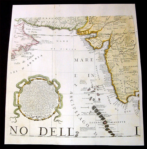
1693 Coronelli Antique Map Globe Gore Section of India, Pakistan, Saudi Arabia
- Title : Parton Da Goa Per Andare al Capo
- Ref #: 31943
- Size: 11 1/2in x 11 1/2in (295mm x 295mm)
- Date : 1693
- Condition: (A) Very Good Condition
Description:
This fine, beautifully hand coloured original antique map - a section of a Globe Gore - of India, Saudi Arabia, the Persian Gulf & Pakistan was published by Vincenzo Maria Coronelli (1650 - 1718) in the 1693 Venice edition of Atlante Veneto, Libro dei Globi.
The Gore is printed on heavy, clean cabled paper late 17th century paper.
The original copper-plates for these gores were engraved in 1688 by Coronelli for the construction of his large 42in (110cm) terrestrial globe.
In 1693 Coronelli published all his gores - from the 2in to the 42 in - in an atlas, Libero dei Globi, part of the great series of atlases, Atlante Veneto. Libero dei Globi was published by Coronelli to ensure his work was available to a wider audience, as very few could afford travel to Venice, Rome or Paris to view his completed globes.
Background: In the early 1680’s Vincenzo Coronelli constructed two vast 15ft diameter terrestrial & celestial globes for Louis XIV of France. These were meticulously hand drawn & engraved. Such was the admiration of these Globes that in 1688 Coronelli began the engraving & publication of Globe Gores for the construction of two 110cm (42in) terrestrial & celestial globes.
Coronellis claim to have produced the best globes of any age was exemplified by the high demand and purchase of the globes by various institutions & cities within Europe. Yet many scholars still did not have the opportunity to visit Paris, London, Rome or Venice to view them and so Coronelli devised his famous atlas Libero dei Globi the first atlas of globe gores ever produced. The Libro formed part of a great series of atlases by Coronelli, the Atlante Veneto, in which Coronelli was able to combine the two cartographic art forms in which he excelled, maps & globes.
The engraving of the gores was of the highest standard with neat contrasting lettering and five large cartouches of a singular grace and elegance. One cartouche situated below Australia carries a portrait of the author and Pope Alexander VI.
Some of the more interesting features contained within the Gores are the recording of recent French explorations in North America, such as La Salles journey to the mouth of the Mississippi in 1681-87 & the French possessions within North America. Elsewhere the Caspian Sea is drawn closer to its modern shape, the Nile in Africa is shown without its fictitious source and the Blue Nile is shown correctly from a large lake in Ethiopia. The tracks of Le Maire crossing of the Pacific in 1616 are marked, as is the voyage of Chaumont to Siam in 1685-6. There are an unusual number of legends, all explanatory and informative along with many vignettes of ships and fishing scenes throughout the globe.
Coronelli was one of the finest engravers & cartographers of any era, producing some of the most stunning work ever seen. These Globe Gores are no exception. Coronelli was a master craftsman with an eye for detail. You can feel the uncompromising accuracy & passion in his work when you study his maps & globes.
These globe gores are scarce, with only a few sales records from the last 25 years. Similarly there is very little choice currently on the market. This scarcity ensures ongoing value and future appreciation. (Ref: Shirley 538; Tooley; Dr. Helen Wallis The Map Collector Dec 1980;Armao, Ermanno. Vincenzo Coronelli Cenni sull'uomo e la sua Vita Catalogo... Bibliopolis, Florence pp.130-134)
General Description:
Paper thickness and quality: - Heavy and stable
Paper color: - white
Age of map color: - Later
Colors used: - Yellow, green, pink
General color appearance: - Fresh
Paper size: - 11 1/2in x 11 1/2in (295mm x 295mm)
Margins: - min. 1/2in (10mm)
Imperfections:
Margins: - Margins cropped past plate-mark
Plate area: - Vertical crease, small binding holes
Verso: - Vertical crease, small binding holes
1693 Slezer Antique Print Fortrose View of Ross-shire, Scotland
- Title : The Channery Town of Ross
- Ref : 24952
- Size: 16 ½in x 10 ½in (420mm x 270mm)
- Date : 1693
- Condition: (A+) Fine Condition
Description:
This fine beautifully hand coloured original antique print a view of Fortrose - in the Shire of Ross, Northern Scotland - was published in the 1718 edition of John Slezer's 'Theatrum Scotiae', published in 1693.
Fortrose in Ross-shire sits on the edge of the Moray Firth. In Slezer's view you see the ruins of the town's cathedral, which fell into decline after the Reformation in 1560.
Fortrose consists of two towns, Chanonry (or as Slezer writes, 'Channery') and Rosemarkie, which were formally united in 1592 under the name Fortrose. From the 12th century, Rosemarkie was the seat of the Bishopric of Ross, but the cathedral and former bishop's residence were largely removed by Cromwell in the 1650s.
In front of the town are run-rigs unenclosed strips of separately cultivated ground. These were typical in the Scottish landscape of the 17th and early 18th centuries.
This is an important and rare print as Slezer s Theatrum Scotiae is one of the earliest records of early Scottish towns. (Ref: Tooley; M&B)
General Description:
Paper thickness and quality: - Heavy and stable
Paper color: - off white
Age of map color: - Early
Colors used: - Green, yellow, orange, blue
General color appearance: - Authentic
Paper size: - 16 ½in x 10 ½in (420mm x 270mm)
Plate size: - 16 ½in x 10 ½in (420mm x 270mm)
Margins: - Min 1/4in (7mm)
Imperfections:
Margins: - Cropped to plate-mark
Plate area: - None
Verso: - None
1700 De Fer Large Antique Map Northern Europe, Latvia, Lithuania, Poland, Baltic
- Title : Carte Des Estats De Suede, De Dannemark, Et De Pologne sur la Mer Baltique
- Ref #: 16296
- Size: 28in x 18in (710mm x 460mm)
- Date : 1700
- Condition: (A) Very Good Condition
Description:
Large decorative early 18th Century map of the Baltics, Poland, central & western Europe by the noted French Cartographer Nicolas De Fer was engraved by Herman van Loon in 1700 - dated in bottom right cartouche - and was published in De Fers 1705 edition of Atlas ou Recueil de Cartes Geographiques Dressees.
Background: De Fer's two-sheet map of northern Europe extends from Belgium through the Baltic states and over to Smolensk and Braclaw. Major trade routes, both on sea and land, are traced throughout the map. Van Loon engraved this beautiful map and richly embellished it with three cartouches. The primary title cartouche fills the upper-left corner with scenes of war and victory, and below that is an inset map of Hven Island, the location of Tycho Brahe's observatory. In the opposite corner is a secondary title cartouche Carte des Estats de Suede, de Dannemarq, et de Pologne; sur la Mer Baltique…flanked by a bear at left and a galloping horse at right. The scale of miles cartouche is festooned with wind heads blowing strong, wintry winds. The coordinates for major cities are noted within the borders. (Ref Tooley M&B)
General Description:
Paper thickness and quality: - Heavy and stable
Paper color: - off white
Age of map color: - Original & later
Colors used: - Yellow, green, pink
General color appearance: - Authentic
Paper size: - 28in x 18in (710mm x 460mm)
Plate size: - 28in x 18in (710mm x 460mm)
Margins: - Min ½in (8mm)
Imperfections:
Margins: - Chipping to margin edges
Plate area: - Light creasing to left sheet
Verso: - Repair to left sheet approx. 25cm, re-enforced on verso with archival tape on creasing & small tears
1704 Delisle Large Antique Map Rhine River, Alsace, France & Germany
- Title : Le Cours Du Rhin....1704
- Ref #: 32291
- Size: 26in x 20in (660mm x 510mm)
- Date : 1704
- Condition: (A) Very Good Condition
Description:
This large beautifully hand coloured original antique map of a section of the Rhine River in France - from Strasbourg in the north to the Swiss Border - was engraved in 1704 - the date is engraved in the title - by Guillaume de L'Isle. (Ref: M&B; Tooley)
Condition Report
Paper thickness and quality: - Very heavy and stable
Paper color: - Off white
Age of map color: - Original
Colors used: - Yellow, green, pink
General color appearance: - Authentic
Paper size: - 26in x 20in (660mm x 510mm)
Plate size: - 25 1/2in x 19 1/2in (650mm x 495mm)
Margins: - min. 1/4in (5mm)
Imperfections:
Margins: - None
Plate area: - None
Verso: - Light soiling
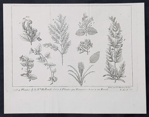
1705 William Dampier Original Antique Print Plants from NW Australia, Broome & Brazil
- Title : 1..2.3.4. Plantee de la Nle. Hollande 5.6.7.8. Plantes que Dampierre trouva au Brezil
- Ref : 61043
- Size: 8 1/2in x 6 1/2in (215mm x 165mm)
- Date : 1705
- Condition: (A+) Fine Condition
Description:
This original copper-plate engraved antique print of various plants and flowers from Australia & Brazil was engraved by Louise Duvivier Tardieu and published in the 1705 French edition of William Dampiers Voyages and Travels.
General Definitions:
Paper thickness and quality: - Heavy and stable
Paper color : - off white
Age of map color: -
Colors used: -
General color appearance: -
Paper size: - 8 1/2in x 6 1/2in (215mm x 165mm)
Plate size: - 8 1/2in x 6 1/2in (215mm x 165mm)
Margins: - Min 1/2in (12mm)
Imperfections:
Margins: - None
Plate area: - Folds as issued
Verso: - None
Background:
In 1688 William Dampier (1652-1715) was the first Englishman to land in Australia. He arrived on the west coast in privateer ship Cygnet which was grounded for repairs at Shark Bay for two months. As he had done in Brazil, and would also do in New Guinea, Dampier sketched flora, fauna and native people during this time. After his return to England these simple sketches were published in 1697 in Dampier’s book A New Voyage Round the World. Usually nature discoveries were published with contemporary colour - each hand-coloured in accordance with the drawing from the artist on the voyage, but paintboxes were probably not priority for pirates, and his botanical engravings remained uncoloured when published.
During more than twelve years, in just as many ships and various voyages, Dampier circumnavigated the world three times – and became the first to do so. His stories of his travels were well-received by the public and he revised and published to accommodate their popularity. Travel was something that most people could only be read about, and stories of discoveries were popular everywhere. From 1705 Dampier’s “Voyages and Discoveries” were even published in France.
Dampier arrived on the west coast of Australia in 1688 Cygnet was grounded for repairs for two months at Shark Bay. As he had done in Brazil and would do in New Guinea, William Dampier sketched local flowers, plants and grasses, birds and animals, and natives. He was not impressed with the terrain. After his return to England, copperplate engravings from these simple sketches were published in 1697 for Dampier’s A New Voyage Round the World. Usually nature discoveries were published with contemporary colour - each hand-coloured in accordance with the drawing from the artist on the voyage, but Dampier probably didn’t have a paintbox with him, so his botanical engravings remained uncoloured when published.
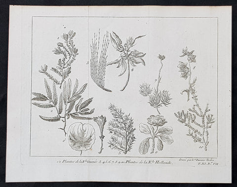
1705 William Dampier Original Antique Print Plants from NW Australia, Broome & PNG
- Title : 1.2. Plantes de la Nle Guinee 3.4. 5.6.7.8.9.10 Plantes de la N.le Hollande
- Ref : 61044
- Size: 8 1/2in x 6 1/2in (215mm x 165mm)
- Date : 1705
- Condition: (A+) Fine Condition
Description:
This original copper-plate engraved antique print of various plants and flowers from Australia & New Guinea was engraved by Louise Duvivier Tardieu and published in the 1705 French edition of William Dampiers Voyages and Travels.
General Definitions:
Paper thickness and quality: - Heavy and stable
Paper color : - off white
Age of map color: -
Colors used: -
General color appearance: -
Paper size: - 8 1/2in x 6 1/2in (215mm x 165mm)
Plate size: - 8 1/2in x 6 1/2in (215mm x 165mm)
Margins: - Min 1/2in (12mm)
Imperfections:
Margins: - None
Plate area: - Folds as issued
Verso: - None
Background:
In 1688 William Dampier (1652-1715) was the first Englishman to land in Australia. He arrived on the west coast in privateer ship Cygnet which was grounded for repairs at Shark Bay for two months. As he had done in Brazil, and would also do in New Guinea, Dampier sketched flora, fauna and native people during this time. After his return to England these simple sketches were published in 1697 in Dampier’s book A New Voyage Round the World. Usually nature discoveries were published with contemporary colour - each hand-coloured in accordance with the drawing from the artist on the voyage, but paintboxes were probably not priority for pirates, and his botanical engravings remained uncoloured when published.
During more than twelve years, in just as many ships and various voyages, Dampier circumnavigated the world three times – and became the first to do so. His stories of his travels were well-received by the public and he revised and published to accommodate their popularity. Travel was something that most people could only be read about, and stories of discoveries were popular everywhere. From 1705 Dampier’s “Voyages and Discoveries” were even published in France.
Dampier arrived on the west coast of Australia in 1688 Cygnet was grounded for repairs for two months at Shark Bay. As he had done in Brazil and would do in New Guinea, William Dampier sketched local flowers, plants and grasses, birds and animals, and natives. He was not impressed with the terrain. After his return to England, copperplate engravings from these simple sketches were published in 1697 for Dampier’s A New Voyage Round the World. Usually nature discoveries were published with contemporary colour - each hand-coloured in accordance with the drawing from the artist on the voyage, but Dampier probably didn’t have a paintbox with him, so his botanical engravings remained uncoloured when published.
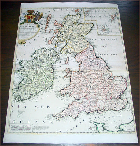
1707 Nolin Coronelli Large Antique Map of Great Britain & Ireland - England
- Title : Les Isles Britanniques ou sont Les Royaumes d Angleterre d Escosse et d Irlande...J B Nolin
- Date : 1707
- Condition: (A+) Fine Condition
- Ref: 43171
- Size: 26in x 19 1/2in (660mm x 495mm)
Description: This large beautifully hand coloured original antique map of Great Britain & Ireland was published by J.B. Nolin in 1707 after the great Italian cartographer Vincenzo Coronelli.
English Cartography: When considering the work of English map makers we tend, perhaps, to think too much in terms of county maps, dominated by the names of Saxton and Speed, but we should not underrate the contribution to the sum of geographical knowledge made in other spheres, such as the sea charts of Edward Wright, Robert Dudley and Greenvile Collins, the discoveries of James Cook, the road maps of Ogilby and Cary, the meteorological and magnetic charts compiled by Edmund Halley, to mention only a few.
In 1558 Queen Elizabeth came to the throne in the midst of a fast changing world. In 1563 a nineteen sheet map, copies of which survive only in manuscript form, was completed by Laurence Nowell, and no doubt, the issue of Mercator's large-scale map of the British Isles in 1564 had an important influence on the thought of the period. A few years later a national survey was commissioned privately, although probably at the instigation of Lord Burghley, the Lord Treasurer, but subsequently was completed with royal encouragement. The outcome was Christopher Saxton's Atlas of EngIand and Wales,started about 1570 and published in 1579 - the first printed set of county maps and the first countrywide atlas on such a splendid scale produced anywhere. A Welsh antiquarian, Humphrey Lhuyd completed a set of surveys that were even more successful than Saxton in which he had produced fine manuscript maps of England and Wales which were used by Ortelius in editions of his Atlas from 1573 onwards.
The earliest maps of the 17th century, attributed to William Smith of the College of Heralds, covered only twelve counties based on Saxton/Norden and were presumably intended to be part of a complete new atlas. They were printed in the Low Countries in 1602-3 and were soon followed by maps for the Latin edition of Camden's Britannia dated 1607. In 1610-11 the first edition of John Speed's famous county AtlasThe Theatre of the Empire of Great Britaine was published and immediately replaced Saxton's in popular appeal. Although Speed assembled much of his material from the earlier works of Saxton, Norden and others, a considerable part of the up-to-date information, especially relating to the inset town plans depicted on his maps, was obtained first hand. The maps undoubtedly owed much of their popularity to the splendid engravings of high quality made in the workshops in Amsterdam of Jodocus Hondius to whom Speed sent his manuscripts, the plates subsequently being returned to London for printing.
In 1645, Volume IV of the famous Blaeu World Atlas covering the counties of England and Wales was published in Amsterdam. These maps have always been esteemed as superb examples of engraving and design, the calligraphy being particularly splendid, but nevertheless they were nearly all based on Saxton and Speed and added little to geographical knowledge.
Not until the latter part of the century do we find an English map maker of originality with the capacity to put new ideas into practice. John Ogilby, one of the more colourful figures associated with cartography, started life as a dancing master and finished as King's Cosmographer and Geographic Printer. After publishing a small number of county maps, somewhat on the lines of John Norden he issued in 1675 the Britannia, the first practical series of detailed maps of the post roads of England and Wales on a standard scale of 1,760 yards to the mile. Up to the end of the century and beyond, reprints and revisions of Saxton's and Speed's atlases continued to appear and the only other noteworthy county maps were Richard Blome's Britannia (1673), John Overton's Atlas (c.1670) and Robert Morden's maps for an English translation of Camden'sBritannia published in 1695.
Another noted cartographer of the day was Captain Greenvile Collins, and of his work in surveying the coasts of Great Britain culminating in the issue in 1693 of the Great Britain's Coasting Pilot. Apart from these charts, English cartographers published during the century a number of world atlases. Speed was the first Englishman to produce a world atlas with the issue in 1627 of his A Prospect of the Most Famous Parts of the World. Other atlases appeared later in the century by Peter Heylin, John Seller, William Berry, Moses Pitt and Richard Blome, whilst Ogilby found time to issue maps of Africa, America and Asia. Far more important, from the purely scientific point of view, was the work of Edmund Halley, Astronomer Royal, who compiled and issued meteorological and magnetic charts in 1688 and 1701 respectively.
At the beginning of the eighteenth century the Dutch map trade was finally in decline, the French in the ascendant and the English to a great extent still dominated by Saxton and Speed except, as we have shown, in the spheres of sea charts and road maps. There were atlases by John Senex, the Bowles family, Emanuel and Thomas Bowen, Thomas Badeslade and the unique bird's-eye perspective views of the counties, The British Monarchy by George Bickham. In 1750-60 Bowen and Kitchin's The Large English Atlas containing maps on a rather larger scale than hitherto was published.
In 1759 the Society for the encouragement of Arts, Manufactures and Commerce offered an award of £100 for the best original surveys on this scale and by the end of the century about thirty counties had been re-surveyed. These maps, many of which formed, in later years, the basis for the first issues of county maps by the Ordnance Survey Office were not only decorative but a tremendous improvement geographically on earlier local maps. As a consequence, the skills and expertise of the new-style cartographers soon enabled them to cover the world as well as the domestic market. Thomas Jefferys was such a man; he was responsible for a number of the new 1 in. to 1 mile county surveys and he issued an edition of Saxton's much battered 200-year-old plates of the county maps, but he is better known for many fine maps of North America and the West Indies. His work was continued on the same lines by William Faden, trading as Faden and Jefferys. Other publishers such as Sayer and Bennett and their successors Laurie and Whittle published a prodigious range of maps, charts and atlases in the second half of the century. A major influence at this time was John Cary who, apart from organizing the first re-survey of post roads since Ogilby and subsequently printing the notedTravellers' Companion, was a prolific publisher of atlases and maps of every kind of all parts of the world. After starting work with Cary, and taking part in the new road survey, Aaron Arrowsmith set up in his own business and went on to issue splendid large-scale maps of many parts of the world. Both Cary's and Arrowsmith's plates were used by other publishers until far into the next century and, in turn, their work was taken up and developed by James Wyld (Elder and Younger) and Tallis and Co.
Later into the 19th century some of the better known cartographers and publishers were by Henry Teesdale (1829-30), Christopher and John Greenwood, surveyors, Thomas Moule, a writer on heraldry and antiques (1830-36) and John Walker (1837) but by about the middle of the century few small-scale publishers survived and their business passed into the hands of large commercial concerns such as Bartholomews of Edinburgh and Philips of London who continue to this day. (Ref: Shirley; Tooley; M&B)
General Description:
Paper thickness and quality: - Heavy and stable
Paper color: - off white
Age of map color: - Original & later
Colors used: - Yellow, green, red, brown.
General color appearance: - Authentic and fresh
Paper size: - 26in x 19 1/2in (660mm x 495mm)
Plate size: - 24in x 18 1/2in (610mm x 470mm)
Margins: - Min 1/16in (2mm)
Imperfections:
Margins: - Top left & bottom right margins cropped to plate-mark
Plate area: - None
Verso: - None
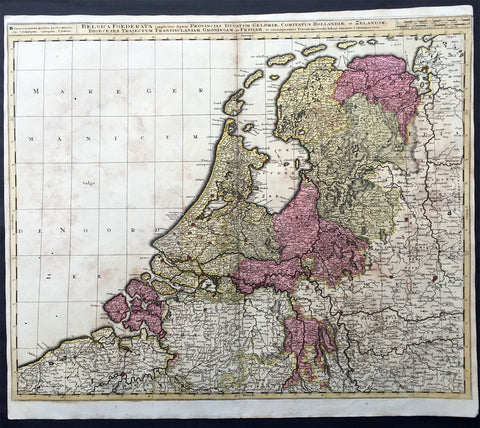
1710 Valk Large Antique Map of The Netherlands, Belgium Federation, Holland
- Title : Belgica Foederata complectens septem Provincias, Ducatus Geldriae, Comitatus Hollandiae et Zelandiae, Dioec. Traject : Transisul : Groningam et Frisiam et circumjacentes Provincias.
- Ref #: 16496
- Size: 24in x 20 1/2in (610mm x 520mm)
- Date : 1710
- Condition: (A) Very Good Condition
Description:
This large somewhat scarce beautifully hand coloured original antique map of The Netherlands was published by Gerard Valck in his rare atlas Nova Totius Geographica Telluris Projecto in 1710.
Background:
It would be hard to imagine a more inauspicious period for a nation's cultural development than the years between 1520 and 1600 in the Low Countries. Under the harsh domination of the Spanish Emperors, facing fanatical religious persecution and the threat of the Inquisition, the constant presence of foreign troops and even the destruction of some of their cities, the Dutch, nevertheless, in 1581 contrived to break their subservience to Spain and form their own federation. Belgium, being mainly Catholic, remained within the orbit of the Empire though henceforward was recognized as a separate state. In such circumstances there would seem to have been little chance for growth of a national entity in the small Northern Provinces but, on the contrary, under the leadership of Amsterdam, their banking and commercial enterprise soon dominated Europe. The attempt by Philip II to eliminate their control of European coastal trade by the use of Portuguese craft inspired the Dutch, first, to seek a North East passage to India and Asia and then, failing that, to challenge Spanish and Portuguese power directly, not only in European waters but also in the East, and eventually to eclipse it. English attempts to gain a foothold in the Indies were bitterly opposed and the English turned their attention to India where only a handful of Dutch settlements existed.
In spite of the turmoil arising out of these events, first Antwerp and then Amsterdam became centres of the arts and their cartographers, engravers and printers produced magnificent maps and charts of every kind which many claim have never been surpassed. Later in this chapter an account is given of Gerard Mercator, who studied at Louvain under Gemma Frisius, the Dutch astronomer and mathematician, and later moved to Duisburg in the Rhineland where most of his major work was carried Out. There he produced globes, maps of Europe, the British Isles and the famous World Map using his newly invented method of projection, all of which were widely copied by most of the cartographers of the day. The first part of his Atlas - the word chosen by Mercator to describe a collection of maps - was published in 1585, the second in 1589, and the third in 1595, a year after his death.
Other great names of the time were Abraham Ortelius, native of Antwerp, famous for his world atlas, Theatrum Orbis Terrarum, issued in 1570; Waghenaer, noted for his sea atlases of 1584 and 1592, Gerard de Jode and Jodocus and Henricus Hondius, followed in the next century by W. J. Blaeu and his sons and Jan Jansson. The Blaeu and Jansson establishments were noted mainly for land atlases but their sea atlases and pilot books were also published in numerous editions which went some way to meeting the rising demand for aids to navigation in European and Mediterranean waters. Their productions were challenged by other, smaller publishers specializing in such works, Jacob Colom, Anthonie Jacobsz, Pieter Goos, Hendrick Doncker, to mention a few, and, later, the charts issued by the van Keulen family and their descendants covered practically all the seas of the known world. As we reach the second half of the seventeenth century the details of publication of these sea atlases and pilot books become more and more interwoven and complicated. Not infrequently the same charts were issued under the imprint of different publishers; at death the engraved plates were sold or passed to their successors and were re-issued, with minor alterations and often without acknowledgement to the originator, all of which adds to problems of identification. Although, in this period, charts of every kind must have been issued in great quantity, good copies are now hard to find.
By about the year 1700 Dutch sea power and influence was waning and although their pilot books and charts remained much in demand for many years to come, leadership in the production of land atlases passed into the hands of the more scientific French cartographers who, in their turn, dominated the map trade for most of the following century. (Ref: Tooley; M&B)
General Description:
Paper thickness and quality: - Heavy and stable
Paper color: - off white
Age of map color: - Original
Colors used: - Yellow, green, pink, blue.
General color appearance: - Authentic
Papaer size: - 24in x 20 1/2in (610mm x 520mm)
Plate size: - 23 1/2in x 19 1/2in (595mm x 495mm)
Margins: - Min 1/2in (10mm)
Imperfections:
Margins: - None
Plate area: - Light soiling, several small worm holes
Verso: - Light soiling
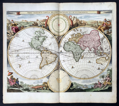
1714 Visscher & Stoopendaal Large Antique Twin Hemisphere World Map
- Title : Orbis Terrarum Tabula Recens Emendata Et In Lucem Edita
- Ref #: 35492
- Size: 19 ½in x 17in (495mm x 430mm)
- Date : 1714
- Condition: (A) Very Good Condition
Description:
This beautifully engraved hand coloured original twin Hemisphere Antique World map by Nicolas Visscher was engraved by Daniel Stoopendaal and published by Pieter Keur, Rotterdam in 1716.
Background:
Nicolas Visschers Twin Hemisphere World Map is regarded as the forerunner of a number of highly decorative Dutch world maps produced throughout the latter part of the 17th & early 18th centuries.
Essentially based on Blaeu's large world map of 1648, Visscher introduced no substantial new geographical features, however there were minor variations in the still unknown coastline of North America.
The northern part of California (as an Island) has now been flattened and is now called New Albion; still further north a small piece of land or an island "Anian" appears adjacent to a strait leading within striking distance of the west shores of Hudson Bay, a possible early guess at a NW passage.
The distinctive attractiveness of many 17th century Dutch world maps is to be found in their border decorations and this one is no exception. The original artist assisting Visscher, Nicolas Berchem, introduced dramatic classical scenes. Daniel Stoopendaal carried on this tradition by representing each of the 4 know continents in allographical form in the 4 corners Europe, Asia, Africa & The America's. Another small change was the inclusion of astronomical diagrams replacing the north & south polar projections located at the top and bottom of the map.
The Keur family produced a number of fine maps from their presses at Dordrecht and later from Rotterdam in the 17th & 18th centuries. This finely executed twin hemisphere world map is a classic example being first released by Nicolas Visscher and Nicolas Berchem in 1658. (Ref: Shirley; Tooley)
General Description:
Paper thickness and quality: - Heavy and stable
Paper colour: - off white
Age of map colour: - Early colour
Colours used: - Yellow, pink, green, orange
General colour appearance: - Beautifully applied
Plate size: - 19 ½in x 17in (495mm x 430mm)
Plate size: - 18 ½in x 14 ½in (470mm x370mm)
Margins: - Min 1/2in (12mm)
Imperfections:
Margins: - Light age toning in margins
Plate area: - Several small worm holes professionally repaired
Verso: - Light age toning
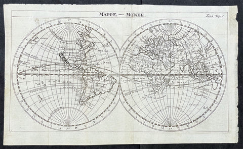
1715 William Dampier Antique Twin Hemisphere World Map, California Is. Australia
- Title : Mappe-Monde
- Ref #: 17026
- Size: 12in x 7 1/2in (305mm x 190mm)
- Date : 1715
- Condition: (A) Very Good Condition
Description:
This beautiful copper-plate engraved scarce, original antique Twin Hemisphere World Map by William Dampier was published in the 1715 French edition of A New Voyage Around the World (Nouveau Voyage autour du Monde)
Fantastic map showing the route taken by Dampier on his first voyage in his ship Roebuck, visiting NW Australia, GOM and Southern Africa whilst circumnavigating the world. California is shown as an island as was the popular belief at the time.
Background: William Dampier (1651 - 1715) was an English explorer and navigator who became the first Englishman to explore parts of what is today Australia, and the first person to circumnavigate the world three times. He has also been described as Australia's first natural historian, as well as one of the most important British explorers of the period between Sir Walter Raleigh and James Cook.
After impressing the Admiralty with his book A New Voyage Round the World, Dampier was given command of a Royal Navy ship and made important discoveries in western Australia, before being court-martialled for cruelty. On a later voyage he rescued Alexander Selkirk, a former crewmate who may have inspired Daniel Defoe's Robinson Crusoe. Others influenced by Dampier include James Cook, Horatio Nelson, Charles Darwin.
In 1679, Dampier joined the crew of the buccaneer Captain Bartholomew Sharp on the Spanish Main of Central America, twice visiting the Bay of Campeche, or "Campeachy" as it was then known, on the north coast of Mexico. This led to his first circumnavigation, during which he accompanied a raid across the Isthmus of Darién in Panama and took part in the capture of Spanish ships on the Pacific coast of that isthmus. The pirates then raided Spanish settlements in Peru before returning to the Caribbean.
Dampier made his way to Virginia, where in 1683 he was engaged by the privateer John Cooke. Cooke entered the Pacific via Cape Horn and spent a year raiding Spanish possessions in Peru, the Galápagos Islands, and Mexico. This expedition collected buccaneers and ships as it went along, at one time having a fleet of ten vessels. Cooke died in Mexico, and a new leader, Edward Davis, was elected captain by the crew.
Dampier transferred to the privateer Charles Swan's ship, Cygnet, and on 31 March 1686 they set out across the Pacific to raid the East Indies, calling at Guam and Mindanao. Spanish witnesses saw the predominantly English crew as not only pirates and heretics but also cannibals. Leaving Swan and 36 others behind on Mindanao, the rest of the privateers sailed on to Manila, Poulo Condor, China, the Spice Islands, and New Holland. Contrary to Dampier's later claim that he had not actively participated in actual piratical attacks during this voyage, he was in fact selected in 1687 to command one of the Spanish ships captured by Cygnet's crew off Manila.
On 5 January 1688, Cygnet "anchored two miles from shore in 29 fathoms" on the northwest coast of Australia, near King Sound. Dampier and his ship remained there until March 12, and while the ship was being careened Dampier made notes on the fauna and flora and the indigenous peoples he found there. Among his fellows were a significant number of Spanish sailors, most notably Alonso Ramírez, a native of San Juan, Puerto Rico Later that year, by agreement, Dampier and two shipmates were marooned on one of the Nicobar Islands. They obtained a small canoe which they modified after first capsizing and then, after surviving a great storm at sea, called at "Acheen" (Aceh) in Sumatra.
Dampier returned to England in 1691 via the Cape of Good Hope, penniless but in possession of his journals. He also had as a source of income a slave known as Prince Jeoly (or Giolo), from Miangas (now Indonesia), who became famous for his tattoos (or "paintings" as they were known at the time). Dampier exhibited Jeoly in London, thereby also generating publicity for a book based on his diaries.
The publication of the book, A New Voyage Round the World, in 1697 was a popular sensation, creating interest at the Admiralty. In 1699, Dampier was given command of the 26-gun warship HMS Roebuck, with a commission from King William III (who had ruled jointly with Queen Mary II until her death in 1694). His mission was to explore the east coast of New Holland, the name given by the Dutch to what is now Australia, and Dampier's intention was to travel there via Cape Horn.
The expedition set out on 14 January 1699, too late in the season to attempt the Horn, so it headed to New Holland via the Cape of Good Hope instead. Following the Dutch route to the Indies, Dampier passed between Dirk Hartog Island and the Western Australian mainland into what he called Shark Bay on 6 August 1699. He landed and began producing the first known detailed record of Australian flora and fauna. The botanical drawings that were made are believed to be by his clerk, James Brand. Dampier then followed the coast north-east, reaching the Dampier Archipelago and Lagrange Bay, just south of what is now called Roebuck Bay, all the while recording and collecting specimens, including many shells. From there he bore northward for Timor. Then he sailed east and on 3 December 1699 rounded New Guinea, which he passed to the north. He traced the south-eastern coasts of New Hanover, New Ireland and New Britain, charting the Dampier Strait between these islands (now the Bismarck Archipelago) and New Guinea. En route, he paused to collect specimens such as giant clams.
By this time, Roebuck was in such bad condition that Dampier was forced to abandon his plan to examine the east coast of New Holland while less than a hundred miles from it. In danger of sinking, he attempted to make the return voyage to England, but the ship foundered at Ascension Island on 21 February 1701. While anchored offshore the ship began to take on more water and the carpenter could do nothing with the worm-eaten planking. As a result, the vessel had to be run aground. Dampier's crew was marooned there for five weeks before being picked up on 3 April by an East Indiaman and returned home in August 1701.
Although many papers were lost with Roebuck, Dampier was able to save some new charts of coastlines, and his record of trade winds and currents in the seas around Australia and New Guinea. He also preserved a few of his specimens. In 2001, the Roebuck wreck was located in Clarence Bay, Ascension Island, by a team from the Western Australian Maritime Museum. Because of his widespread influence, and also because so little exists that can now be linked to him, it has been argued that the remains of his ship and the objects still at the site on Ascension Island – while the property of Britain and subject to the island government's management – are actually the shared maritime heritage of those parts of the world first visited or described by him. His account of the expedition was published as A Voyage to New Holland in 1703.
The War of the Spanish Succession had broken out in 1701, and English privateers were being readied to act against French and Spanish interests. Dampier was appointed commander of the 26-gun ship St George, with a crew of 120 men. They were joined by the 16-gun Cinque Ports with 63 men, and sailed on 11 September 1703 from Kinsale, Ireland. The two ships made a storm-tossed passage round Cape Horn, arriving at the Juan Fernández Islands off the coast of Chile in February 1704. While watering and provisioning there, they sighted a heavily armed French merchantman, which they engaged in a seven-hour battle but were driven off.
Dampier succeeded in capturing a number of small Spanish ships along the coast of Peru, but released them after removing only a fraction of their cargoes because he believed they "would be a hindrance to his greater designs. The greater design he had in mind was a raid on Santa María, a town on the Gulf of Panama rumoured to hold stockpiles of gold from nearby mines. When the force of seamen he led against the town met with unexpectedly strong resistance, however, he withdrew. In May 1704, Cinque Ports separated from St George and, after putting Alexander Selkirk ashore alone on an island for complaining about the vessel's seaworthiness, sank off the coast of what is today Colombia. Some of its crew survived being shipwrecked but were made prisoners of the Spanish.
It was now left to St George to make an attempt on the Manila galleon, the main object of the expedition. The ship was sighted on 6 December 1704, probably Nuestra Señora del Rosario. It was caught unprepared and had not run out its guns. But while Dampier and his officers argued over the best way to mount an attack, the galleon got its guns loaded and the battle was joined. St George soon found itself out-sized by the galleon's 18- and 24-pounders, and, suffering serious damage, they were forced to break off the attack.
The failure to capture the Spanish galleon completed the break-up of the expedition. Dampier, with about thirty men, stayed in St George, while the rest of the crew took a captured barque across the Pacific to Amboyna in the Dutch settlements. The undermanned and worm-damaged St George had to be abandoned on the coast of Peru. He and his remaining men embarked in a Spanish prize for the East Indies, where they were thrown into prison as pirates by their supposed allies the Dutch but later released. Now without a ship, Dampier made his way back to England at the end of 1707.
In 1708, Dampier was engaged to serve on the privateer Duke, not as captain but as sailing master. Duke beat its way into the South Pacific Ocean round Cape Horn in consort with a second ship, Duchess. Commanded by Woodes Rogers, this voyage was more successful: Selkirk was rescued on 2 February 1709, and the expedition amassed £147,975 (equivalent to £19.9 million today) worth of plundered goods. Most of that came from the capture of a Spanish galleon, Nuestra Señora de la Encarnación y Desengaño, along the coast of Mexico in December 1709.
In January 1710, Dampier crossed the Pacific in Duke, accompanied by Duchess and two prizes. They stopped at Guam before arriving in Batavia. Following a refit at Horn Island (near Batavia) and the sale of one of their prize ships, they sailed for the Cape of Good Hope where they remained for more than three months awaiting a convoy. They left the Cape in company with 25 Dutch and English ships, with Dampier now serving as sailing master of Encarnación. After a further delay at the Texel, they dropped anchor at the Thames in London on 14 October 1711.
Dampier may not have lived to receive all of his share of the expedition's gains. He died in the Parish of St Stephen Coleman Street, London. The exact date and circumstances of his death, and his final resting place, are all unknown. His will was proven on 23 March 1715, and it is generally assumed he died earlier that month, but this is not known with any certainty. (Ref Tooley M&B)
General Description:
Paper thickness and quality: - Heavy and stable
Paper color: - off white
Age of map color: -
Colors used: -
General color appearance: -
Paper size: - 12in x 7 1/2in (305mm x 190mm)
Plate size: - 12in x 7 1/2in (305mm x 190mm)
Margins: - Min 1/4in (5mm)
Imperfections:
Margins: - Folds as issued
Plate area: - Folds as issued
Verso: - Folds as issued
1717 Jaillot, Sanson Large Old, Antique Map of Russia, Siberia, Baltic, Crimea
- Title : La Russie Blanche ou Moscovie Divisee Suivant l'Estendue Des Royaumes Duches...1717
- Ref #: 50679
- Size: 28 1/2in x 21in (720mm x 535mm)
- Date : 1717
- Condition: (A+) Fine Condition
Description:
This large, beautifully hand coloured original antique map of European Russia by Alexis Hubert Jaillot - after Nicolas Sanson - was engraved in 1717 - the date is engraved in the scale cartouche.
Beautifully presented Jaillot map, fantastic colour, clean and heavy paper and a deep clear impression, signifying an early pressing.
Background: It is scarcely necessary to look at a map of Russia - with which we must include Siberia - to visualize the daunting task facing Russian map makers. Indeed, considering the vastness of their territory and the lack of skilled cartographers, it is surprising that relatively good maps were available for engraving and printing in most of the well known sixteenth and seventeenth century atlases. Generally, maps of that time were based on material brought back from Moscow by visitors from the West.
After Nicolas Sanson, Hubert Jaillot and Pierre Duval were the most important French cartographers of the seventeenth centuries. Jaillot, originally a sculptor, became interested in geography after his marriage to the daughter of Nicolas Berey (1606-65), a famous map colourist, and went into partnership in Paris with Sanson's sons. There, from about 1669, he undertook the re-engraving, enlarging and re-publishing of the Sanson maps in sheet form and in atlases, sparing no effort to fill the gap in the map trade left by the destruction of Blaeu's printing establishment in Amsterdam in 1672. Many of his maps were printed in Amsterdam (by Pierre Mortier) as well as in Paris. One of his most important works was a magnificent sea atlas, Le Neptune François, published in 1693 and compiled in co-operation with J D Cassini. This was re-published shortly afterwards by Pierre Mortier in Amsterdam with French, Dutch and English texts, the charts having been re-engraved. Eventually, after half a century, most of the plates were used again as the basis for a revised issue published by J N Bellin in 1753.(Ref: Tooley; M&B)
General Description:
Paper thickness and quality: - Heavy and stable
Paper color: - off white
Age of map color: - Early
Colors used: - Yellow, green, red, brown.
General color appearance: - Authentic
Paper size: - 28 1/2in x 21in (720mm x 535mm)
Plate size: - 26in x 18 1/2in (660mm x 470mm)
Margins: - Min 1/2in (12mm)
Imperfections:
Margins: - None
Plate area: - None
Verso: - None
1719 Chatelain Large Antique Map of Caribbean Antilles Guadeloupe to Grenada
- Title : Carte des Antilles Francois Et Des Isles Voisines Dressee Sur Des Memoires Manuscrits
- Ref #: 50618
- Size: 21 1/2in x 19 1/4in (550m x 490m)
- Date : 1719
- Condition: (A+) Fine Condition
Description:
This large beautifully hand coloured original antique map of the Caribbean Antilles Islands from Guadeloupe south to the island of Grenada was published by Henri AbrahamChatelain in 1719, in his famous Atlas Historique.
Henri Abraham Chatelain (1684 - 1743)
was a Huguenot pastor of Parisian origins. He lived consecutively in Paris, St. Martins, London (c. 1710), the Hague (c. 1721) and Amsterdam (c. 1728).
Chatelain was a skilled artist and knew combining a wealth of historical and geographical information with delicate engraving and an uncomplicated composition. Groundbreaking for its time, this work included studies of geography, history, ethnology, heraldry, and cosmography. His maps with his elegant engraving are a superb example from the golden age of French mapmaking.The publishing firm of Chatelain, Chatelain Frères and Chatelain & Fils is recorded in Amsterdam, from around 1700-1770, with Zacharias living "op den Dam" in 1730.
Henri Abraham Chatelain, his father Zacharie Chatelain (d.1723) and Zacharie Junior (1690-1754), worked as a partnership publishing the Atlas Historique, Ou Nouvelle Introduction à L'Histoire under several different Chatelain imprints, depending on the Chatelain family partnerships at the time of publication. The atlas was published in seven volumes between 1705 and 1720, with a second edition appearing in 1732. The volumes I-IV with a Third edition and volume I with a final edition in 1739.
Henri Abraham Chatelain, whose "Atlas Historique" was one of the most expansive Dutch encyclopedias of the age. First published in 1705, Chatelain's Atlas Historique was part of an immense seven-volume encyclopedia. Although the main focus of the text was geography, the work also included a wealth of historical, political, and genealogical information. The text was compiled by Nicholas Gueudeville and Garillon with a supplement by H.P. de Limiers and the maps were engraved by Chatelain, primarily after charts by De L'Isle. The atlas was published in Amsterdam between 1705 and 1721 and was later reissued by Zacharie Chatelain between 1732 and 1739.
Atlas Historique: First published in Amsterdam from 1705 to 1720, the various volumes were updated at various times up to 1739 when the fourth edition of vol.I appeared, stated as the "dernière edition, corrigée & augmentée."
The first four volumes seem to have undergone four printings with the later printings being the most desirable as they contain the maximum number of corrections and additions. The remaining three final volumes were first issued between 1719-1720 and revised in 1732.
An ambitious and beautifully-presented work, the Atlas Historique was intended for the general public, fascinated in the early eighteenth century by the recently conquered colonies and the new discoveries. Distant countries, such as the Americas, Africa, the Middle East, Mongolia, China, Japan, Indonesia, etc., take an important place in this work.
In addition to the maps, many of which are based on Guillaume De L'Isle, the plates are after the best travel accounts of the period, such as those of Dapper, Chardin, de Bruyn, Le Hay and other.
Other sections deal with the history of the european countries, and covers a wide range of subjects including genealogy, history, cosmography, topography, heraldry and chronology, costume of the world, all illustrated with numerous engraved maps, plates of local inhabitants and heraldic charts of the lineages of the ruling families of the time. The maps, prints and tables required to make up a complete set are listed in detail in each volume.
The accompanying text is in French and often is printed in two columns on the page with maps and other illustrations interspersed. Each map and table is numbered consecutively within its volume and all maps bear the privileges of the States of Holland and West-Friesland.
The encyclopaedic nature of the work as a whole is reflected in this six frontispiece. The pages are the work of the celerated mr. Romeijn de Hooghe. and are engraved by J.Goeree, T.Schynyoet and P.Sluyter.
New scholarship has suggested the compiler of the atlas, who is identified on the title as "Mr. C***" not to be Henri Abraham Châtelain, but Zacharie Châtelain. (See Van Waning's article in the Journal of the International Map Collectors' Society for persuasive evidence of the latter's authorship.) (Ref: M&B; Tooley)
General Description:
Paper thickness and quality: - Heavy and stable
Paper color: - White
Age of map color: - Later
Colors used: - Pink, green, yellow, blue
General color appearance: - Authentic
Paper size: - 21 1/2in x 19 1/4in (550m x 490m)
Plate size: - 19 1/4in x 13 1/2in (490m x 345mm)
Margins: - min. 1in (25mm)
Imperfections:
Margins: - None
Plate area: - Folds as issued
Verso: - None
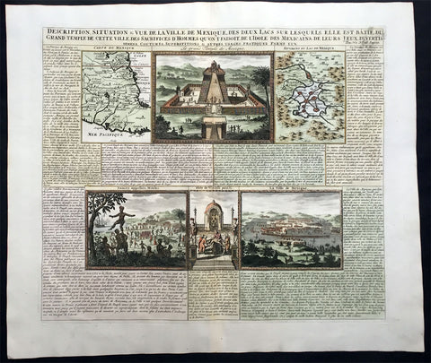
1719 Chatelain Large Antique Maps and Views of Mexico & Mexico City
- Title : Description, Situation & Vue De La Ville De Mexique, Des Deux Lacs
- Ref #: 50634
- Size: 20 3/4in x 17 1/2in (530m x 445m)
- Date : 1719
- Condition: (A+) Fine Condition
Description:
An exceptionally beautiful example of Abraham Chatelain's 1719 maps and views on Mexico.
This sheet combines two maps and four engraved views with extensive text describing the lands and customs of Mexico. The maps, appearing in the upper right and left quadrants detail central Mexico and Mexico City.
The first map located in the upper left, is centered on Mexico City and details from the Gulf of Mexico to the Pacific and from the Rio de Palmas to Acapulco. The second map, in the upper right, focuses more specifically on Mexico City, revealing the ancient Lake Texcoco, and the cultivated islands that once housed the great Aztec capital.
Between the two maps a large view depicts a typical Aztec temple complex. The lower views detail, from left, traditional Aztec dances with a Spanish galleon in the background, human sacrifice, and a general view of Mexico City combining European and Aztec architectural elements. The extensive surrounding text, in French, attempt to describe the customs, peoples, resources, and geography of Mexico
General Description:
Paper thickness and quality: - Heavy and stable
Paper color: - White
Age of map color: - Later
Colors used: - Pink, green, yellow, blue
General color appearance: - Authentic
Paper size: - 20 3/4in x 17 1/2in (530m x 445m)
Plate size: - 17in x 15in (435m x 380mm)
Margins: - min. 1in (25mm)
Imperfections:
Margins: - None
Plate area: - None
Verso: - None
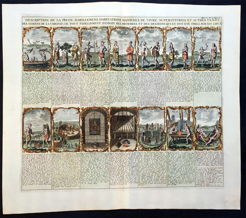
1719 Chatelain Large Antique Print - 14 Views of Indians of Virginia
- Title : Description de la Peche, Habillemens, Habitations, Manieres de Vivre, Superstitions et Autres Usages des Indiens de la Virginie
- Date : 1719
- Ref # : 50636
- Size : 20in x 17 1/2in (510m x 440m)
- Condition: (A+) Fine Condition
Description:
This large hand coloured original antique print a decorative series of 14 views of the customs, clothing and daily lives of the Native Inhabitants of Virginia was published by Henri Abraham Chatelain in 1719, in his famous Atlas Historique. of the 16th Century.
These 14 views of native American life in Virginia - taken from Theodor de Bry's America, which are engraved from John White's drawings - includes the manner of dressing, fishing, hunting, making canoes, eating, cooking, living, worshipping, as well as burial practices and ceremonies. Each of the 14 scenes includes an explanation in French.
General Description:
Paper thickness and quality: - Heavy and stable
Paper color: - White
Age of map color: - Later
Colors used: - Yellow, orange, blue, green
General color appearance: - Authentic
Paper size: - 20in x 17 1/2in (510m x 450m)
Plate size: - 19 1/2in x 16 1/2in (440m x 380mm)
Margins: - min. 1in (25mm)
Imperfections:
Margins: - None
Plate area: - None
Verso: - None
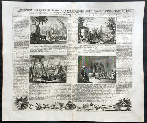
1719 Chatelain Large Antique Print of 4 Various African Village Scenes
- Title : Description des Cases ou Habitations Des Negres, De Celle, Du RoiD Issiny & De ses Suites
- Ref : 50644
- Size: 20in x 17 1/2in (510mm x 445mm)
- Date : 1719
- Condition: (A+) Fine Condition
Description:
This large finely engraved original antique page with 4 views on showing different African village scenes with extensive text was published by Henri Abraham Chatelain in 1719, in his famous Atlas Historique.
These scenes were copied extensively throughout the 18th century in publications like Prevosts voyages.
Henri Abraham Chatelain (1684 - 1743)
was a Huguenot pastor of Parisian origins. He lived consecutively in Paris, St. Martins, London (c. 1710), the Hague (c. 1721) and Amsterdam (c. 1728).
Chatelain was a skilled artist and knew combining a wealth of historical and geographical information with delicate engraving and an uncomplicated composition. Groundbreaking for its time, this work included studies of geography, history, ethnology, heraldry, and cosmography. His maps with his elegant engraving are a superb example from the golden age of French mapmaking.The publishing firm of Chatelain, Chatelain Frères and Chatelain & Fils is recorded in Amsterdam, from around 1700-1770, with Zacharias living "op den Dam" in 1730.
Henri Abraham Chatelain, his father Zacharie Chatelain (d.1723) and Zacharie Junior (1690-1754), worked as a partnership publishing the Atlas Historique, Ou Nouvelle Introduction à L'Histoire under several different Chatelain imprints, depending on the Chatelain family partnerships at the time of publication. The atlas was published in seven volumes between 1705 and 1720, with a second edition appearing in 1732. The volumes I-IV with a Third edition and volume I with a final edition in 1739.
Henri Abraham Chatelain, whose "Atlas Historique" was one of the most expansive Dutch encyclopedias of the age. First published in 1705, Chatelain's Atlas Historique was part of an immense seven-volume encyclopedia. Although the main focus of the text was geography, the work also included a wealth of historical, political, and genealogical information. The text was compiled by Nicholas Gueudeville and Garillon with a supplement by H.P. de Limiers and the maps were engraved by Chatelain, primarily after charts by De L'Isle. The atlas was published in Amsterdam between 1705 and 1721 and was later reissued by Zacharie Chatelain between 1732 and 1739.
Atlas Historique: First published in Amsterdam from 1705 to 1720, the various volumes were updated at various times up to 1739 when the fourth edition of vol.I appeared, stated as the "dernière edition, corrigée & augmentée."
The first four volumes seem to have undergone four printings with the later printings being the most desirable as they contain the maximum number of corrections and additions. The remaining three final volumes were first issued between 1719-1720 and revised in 1732.
An ambitious and beautifully-presented work, the Atlas Historique was intended for the general public, fascinated in the early eighteenth century by the recently conquered colonies and the new discoveries. Distant countries, such as the Americas, Africa, the Middle East, Mongolia, China, Japan, Indonesia, etc., take an important place in this work.
In addition to the maps, many of which are based on Guillaume De L'Isle, the plates are after the best travel accounts of the period, such as those of Dapper, Chardin, de Bruyn, Le Hay and other.
Other sections deal with the history of the european countries, and covers a wide range of subjects including genealogy, history, cosmography, topography, heraldry and chronology, costume of the world, all illustrated with numerous engraved maps, plates of local inhabitants and heraldic charts of the lineages of the ruling families of the time. The maps, prints and tables required to make up a complete set are listed in detail in each volume.
The accompanying text is in French and often is printed in two columns on the page with maps and other illustrations interspersed. Each map and table is numbered consecutively within its volume and all maps bear the privileges of the States of Holland and West-Friesland.
The encyclopaedic nature of the work as a whole is reflected in this six frontispiece. The pages are the work of the celerated mr. Romeijn de Hooghe. and are engraved by J.Goeree, T.Schynyoet and P.Sluyter.
New scholarship has suggested the compiler of the atlas, who is identified on the title as "Mr. C***" not to be Henri Abraham Châtelain, but Zacharie Châtelain. (See Van Waning's article in the Journal of the International Map Collectors' Society for persuasive evidence of the latter's authorship.) (Ref: M&B; Tooley)
General Description:
Paper thickness and quality: - Heavy and stable
Paper color: - White
Age of map color: -
Colors used: -
General color appearance: -
Paper size: - 20in x 17 1/2in (510mm x 445mm)
Plate size: - 17 1/2in x 15in (445mm x 380mm)
Margins: - min. 1in (25mm)
Imperfections:
Margins: - None
Plate area: - None
Verso: - None
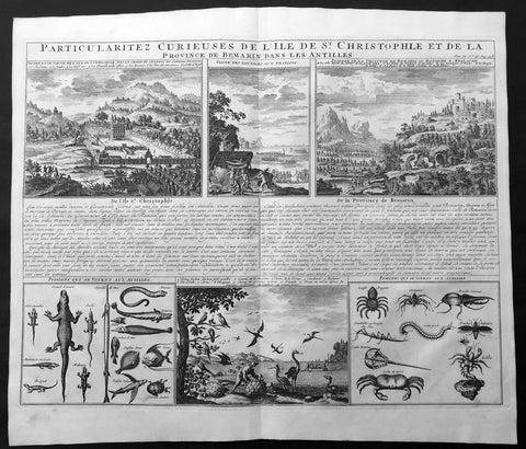
1719 Chatelain Large Antique Print of St Christopher Island, Antilles, Caribbean
- Title : Particularitez Curieuses De L'ile De St. Christopher et de la Province de Bemarin Dans Les Antilles
- Ref : 50630
- Size: 20in x 17in (510m x 430m)
- Date : 1719.
- Condition: (A+) Fine Condition
Description:
This large original antique sheet with engraved illustrations to text on the West Indian Island of St Christopher was published by Henri Abraham Chatelain in 1719, in his famous Atlas Historique.
This large sheet from Volume Six of Chatelain's Atlas Historique , contains six engraved views of the Island of the main French settlement, local Indians, plantations, different types of birds, reptiles, fish and general wildlife.
Henri Abraham Chatelain (1684 - 1743)
was a Huguenot pastor of Parisian origins. He lived consecutively in Paris, St. Martins, London (c. 1710), the Hague (c. 1721) and Amsterdam (c. 1728).
Chatelain was a skilled artist and knew combining a wealth of historical and geographical information with delicate engraving and an uncomplicated composition. Groundbreaking for its time, this work included studies of geography, history, ethnology, heraldry, and cosmography. His maps with his elegant engraving are a superb example from the golden age of French mapmaking.The publishing firm of Chatelain, Chatelain Frères and Chatelain & Fils is recorded in Amsterdam, from around 1700-1770, with Zacharias living "op den Dam" in 1730.
Henri Abraham Chatelain, his father Zacharie Chatelain (d.1723) and Zacharie Junior (1690-1754), worked as a partnership publishing the Atlas Historique, Ou Nouvelle Introduction à L'Histoire under several different Chatelain imprints, depending on the Chatelain family partnerships at the time of publication. The atlas was published in seven volumes between 1705 and 1720, with a second edition appearing in 1732. The volumes I-IV with a Third edition and volume I with a final edition in 1739.
Henri Abraham Chatelain, whose "Atlas Historique" was one of the most expansive Dutch encyclopedias of the age. First published in 1705, Chatelain's Atlas Historique was part of an immense seven-volume encyclopedia. Although the main focus of the text was geography, the work also included a wealth of historical, political, and genealogical information. The text was compiled by Nicholas Gueudeville and Garillon with a supplement by H.P. de Limiers and the maps were engraved by Chatelain, primarily after charts by De L'Isle. The atlas was published in Amsterdam between 1705 and 1721 and was later reissued by Zacharie Chatelain between 1732 and 1739.
Atlas Historique: First published in Amsterdam from 1705 to 1720, the various volumes were updated at various times up to 1739 when the fourth edition of vol.I appeared, stated as the "dernière edition, corrigée & augmentée."
The first four volumes seem to have undergone four printings with the later printings being the most desirable as they contain the maximum number of corrections and additions. The remaining three final volumes were first issued between 1719-1720 and revised in 1732.
An ambitious and beautifully-presented work, the Atlas Historique was intended for the general public, fascinated in the early eighteenth century by the recently conquered colonies and the new discoveries. Distant countries, such as the Americas, Africa, the Middle East, Mongolia, China, Japan, Indonesia, etc., take an important place in this work.
In addition to the maps, many of which are based on Guillaume De L'Isle, the plates are after the best travel accounts of the period, such as those of Dapper, Chardin, de Bruyn, Le Hay and other.
Other sections deal with the history of the european countries, and covers a wide range of subjects including genealogy, history, cosmography, topography, heraldry and chronology, costume of the world, all illustrated with numerous engraved maps, plates of local inhabitants and heraldic charts of the lineages of the ruling families of the time. The maps, prints and tables required to make up a complete set are listed in detail in each volume.
The accompanying text is in French and often is printed in two columns on the page with maps and other illustrations interspersed. Each map and table is numbered consecutively within its volume and all maps bear the privileges of the States of Holland and West-Friesland.
The encyclopaedic nature of the work as a whole is reflected in this six frontispiece. The pages are the work of the celerated mr. Romeijn de Hooghe. and are engraved by J.Goeree, T.Schynyoet and P.Sluyter.
New scholarship has suggested the compiler of the atlas, who is identified on the title as "Mr. C***" not to be Henri Abraham Châtelain, but Zacharie Châtelain. (See Van Waning's article in the Journal of the International Map Collectors' Society for persuasive evidence of the latter's authorship.) (Ref: M&B; Tooley)
General Description:
Paper thickness and quality: - Heavy and stable
Paper color: - White
Age of map color: -
Colors used: -
General color appearance: -
Paper size: - 20in x 17in (510m x 430m)
Plate size: - 17 1/4in x 15in (440m x 380mm)
Margins: - min. 1in (25mm)
Imperfections:
Margins: - None
Plate area: - None
Verso: - None
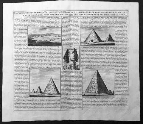
1719 Chatelain Large Antique Print of The Pyramids and Sphinx of Egypt
- Title : Description des Piramides D Egypte Tant au Dedans qu'au Dehors...
- Ref : 50648
- Size: 20in x 17 1/2in (510m x 440m)
- Date : 1719
- Condition: (A+) Fine Condition
Description:
This large original antique print including detailed French Text on the subject was published by Henri Abraham Chatelain in 1719, in his famous Atlas Historique.
Atlas Historique: First published in Amsterdam from 1705 to 1720, the various volumes were updated at various times up to 1739 when the fourth edition of vol.I appeared, stated as the "dernière edition, corrigée & augmentée."
The first four volumes seem to have undergone four printings with the later printings being the most desirable as they contain the maximum number of corrections and additions. The remaining three final volumes were first issued between 1719-1720 and revised in 1732.
An ambitious and beautifully-presented work, the Atlas Historique was intended for the general public, fascinated in the early eighteenth century by the recently conquered colonies and the new discoveries. Distant countries, such as the Americas, Africa, the Middle East, Mongolia, China, Japan, Indonesia, etc., take an important place in this work.
In addition to the maps, many of which are based on Guillaume De L'Isle, the plates are after the best travel accounts of the period, such as those of Dapper, Chardin, de Bruyn, Le Hay and other.
Other sections deal with the history of the european countries, and covers a wide range of subjects including genealogy, history, cosmography, topography, heraldry and chronology, costume of the world, all illustrated with numerous engraved maps, plates of local inhabitants and heraldic charts of the lineages of the ruling families of the time. The maps, prints and tables required to make up a complete set are listed in detail in each volume.
The accompanying text is in French and often is printed in two columns on the page with maps and other illustrations interspersed. Each map and table is numbered consecutively within its volume and all maps bear the privileges of the States of Holland and West-Friesland.
The encyclopaedic nature of the work as a whole is reflected in this six frontispiece. The pages are the work of the celerated mr. Romeijn de Hooghe. and are engraved by J.Goeree, T.Schynyoet and P.Sluyter.
New scholarship has suggested the compiler of the atlas, who is identified on the title as "Mr. C***" not to be Henri Abraham Châtelain, but Zacharie Châtelain. (See Van Waning's article in the Journal of the International Map Collectors' Society for persuasive evidence of the latter's authorship.
General Description:
Paper thickness and quality: - Heavy and stable
Paper color: - White
Age of map color: -
Colors used: -
General color appearance: -
Paper size: - 20in x 17 1/2in (510m x 440m)
Plate size: - 17 1/2in x 15in (440m x 380mm)
Margins: - min. 1in (25mm)
Imperfections:
Margins: - None
Plate area: - None
Verso: - None
1719 Chatelain Large Antique Print of Various Mammals, Birds & Reptiles Elephant
- Title : Description des Quadrupeds, Oiseaux & reptiles les Plus Curieux qui se Trouvent dans la Guinee Dessinez sur les Lieux d Apres le Natural
- Ref : 50643
- Size: 20in x 17 1/2in (510mm x 445mm)
- Date : 1719
- Condition: (A+) Fine Condition
Description:
This large finely engraved original antique page illustrating the different mammals, birds & reptiles of Africa with extensive text was published by Henri Abraham Chatelain in 1719, in his famous Atlas Historique.
These scenes were copied extensively throughout the 18th century in publications like Prevosts voyages.
Henri Abraham Chatelain (1684 - 1743)
was a Huguenot pastor of Parisian origins. He lived consecutively in Paris, St. Martins, London (c. 1710), the Hague (c. 1721) and Amsterdam (c. 1728).
Chatelain was a skilled artist and knew combining a wealth of historical and geographical information with delicate engraving and an uncomplicated composition. Groundbreaking for its time, this work included studies of geography, history, ethnology, heraldry, and cosmography. His maps with his elegant engraving are a superb example from the golden age of French mapmaking.The publishing firm of Chatelain, Chatelain Frères and Chatelain & Fils is recorded in Amsterdam, from around 1700-1770, with Zacharias living "op den Dam" in 1730.
Henri Abraham Chatelain, his father Zacharie Chatelain (d.1723) and Zacharie Junior (1690-1754), worked as a partnership publishing the Atlas Historique, Ou Nouvelle Introduction à L'Histoire under several different Chatelain imprints, depending on the Chatelain family partnerships at the time of publication. The atlas was published in seven volumes between 1705 and 1720, with a second edition appearing in 1732. The volumes I-IV with a Third edition and volume I with a final edition in 1739.
Henri Abraham Chatelain, whose "Atlas Historique" was one of the most expansive Dutch encyclopedias of the age. First published in 1705, Chatelain's Atlas Historique was part of an immense seven-volume encyclopedia. Although the main focus of the text was geography, the work also included a wealth of historical, political, and genealogical information. The text was compiled by Nicholas Gueudeville and Garillon with a supplement by H.P. de Limiers and the maps were engraved by Chatelain, primarily after charts by De L'Isle. The atlas was published in Amsterdam between 1705 and 1721 and was later reissued by Zacharie Chatelain between 1732 and 1739.
Atlas Historique: First published in Amsterdam from 1705 to 1720, the various volumes were updated at various times up to 1739 when the fourth edition of vol.I appeared, stated as the "dernière edition, corrigée & augmentée."
The first four volumes seem to have undergone four printings with the later printings being the most desirable as they contain the maximum number of corrections and additions. The remaining three final volumes were first issued between 1719-1720 and revised in 1732.
An ambitious and beautifully-presented work, the Atlas Historique was intended for the general public, fascinated in the early eighteenth century by the recently conquered colonies and the new discoveries. Distant countries, such as the Americas, Africa, the Middle East, Mongolia, China, Japan, Indonesia, etc., take an important place in this work.
In addition to the maps, many of which are based on Guillaume De L'Isle, the plates are after the best travel accounts of the period, such as those of Dapper, Chardin, de Bruyn, Le Hay and other.
Other sections deal with the history of the european countries, and covers a wide range of subjects including genealogy, history, cosmography, topography, heraldry and chronology, costume of the world, all illustrated with numerous engraved maps, plates of local inhabitants and heraldic charts of the lineages of the ruling families of the time. The maps, prints and tables required to make up a complete set are listed in detail in each volume.
The accompanying text is in French and often is printed in two columns on the page with maps and other illustrations interspersed. Each map and table is numbered consecutively within its volume and all maps bear the privileges of the States of Holland and West-Friesland.
The encyclopaedic nature of the work as a whole is reflected in this six frontispiece. The pages are the work of the celerated mr. Romeijn de Hooghe. and are engraved by J.Goeree, T.Schynyoet and P.Sluyter.
New scholarship has suggested the compiler of the atlas, who is identified on the title as "Mr. C***" not to be Henri Abraham Châtelain, but Zacharie Châtelain. (See Van Waning's article in the Journal of the International Map Collectors' Society for persuasive evidence of the latter's authorship.) (Ref: M&B; Tooley)
General Description:
Paper thickness and quality: - Heavy and stable
Paper color: - White
Age of map color: -
Colors used: -
General color appearance: -
Paper size: - 20in x 17 1/2in (510mm x 445mm)
Plate size: - 17 1/2in x 15in (445mm x 380mm)
Margins: - min. 1in (25mm)
Imperfections:
Margins: - None
Plate area: - Repair to left side of print, no loss
Verso: - None
1719 Chatelain Large Antique Print Succession of Egyptian Pharaohs from 1500BC
- Title : Succession Des Rois D Egipte Selon Leurs Diverses Races (Succession Of The Kings Of Egipte According To Their Various Races)
- Size: 20in x 17 1/2in (510mm x 440mm)
- Condition: (A+) Fine Condition
- Date : 1719
- Ref #: 50652-1
Description:
This large original copper-plate engraved antique print showing the known succession of Egyptian Kings going back to 1500BC was published by Henri Abraham Chatelain in 1719, in his famous Atlas Historique.
General Definitions:
Paper thickness and quality: - Heavy and stable
Paper color : - off white
Age of map color: -
Colors used: -
General color appearance: -
Paper size: - 20in x 17 1/2in (510mm x 440mm)
Plate size: - 17 1/2in x 15in (440mm x 380mm)
Margins: - Min 1in (25mm)
Imperfections:
Margins: - None
Plate area: - None
Verso: - None
Background:
The pharaohs were rulers of Ancient Egypt dating from the unification of Upper and Lower Egypt during the Early Dynastic Period by Narmer approximately 3100 BC. Although the specific term Pharaoh was not used by their contemporaries until the rule of Merneptah of the 19th dynasty, c. 1200 BC, the style of titulature of the rulers of Egypt remained relatively constant, initially featuring a Horus name, a Sedge and Bee (nswt-bjtj) name and a Two Ladies (nbtj) name, with the additional Golden Horus, nomen and prenomen titles being added successively during later dynasties.
Egypt remained continually governed by native pharaohs for approximately 2500 years until it was conquered by the Kingdom of Kush in 656 BC, whose rulers adopted the traditional pharaonic titulature for themselves. Following the Kushite conquest, Egypt would first see another period of independent native rule before being conquered by the Achaemenid Empire, whose rulers also adopted the title of Pharaoh. The last native Pharaoh of Egypt was Nectanebo II, who was Pharaoh before the Achaemenids conquered Egypt for a second time.
Achaemenid rule over Egypt came to an end through the conquests of Alexander the Great in 332 BC, after which it was ruled by the Hellenic Pharaohs of the Ptolemaic Dynasty. Their rule, and the independence of Egypt, came to an end when Egypt became a province of Rome in 30 BC. Augustus and subsequent Roman Emperors were styled as Pharaohs when in Egypt up until the reign of Maximinus Daia in 314 AD.
1719 Chatelain Large Antique Print Views of Cairo, Egypt - Nile
- Title : Vue de la Ville Du Grand Caire et de ses Environs
- Ref #: 50650
- Size: 20in x 17 1/2in (510mm x 445mm)
- Date : 1719
- Condition: (A+) Fine Condition
Description:
This large finely engraved original antique print of various views of Cairo and Environs was published by Henri Abraham Chatelain in 1719, in his famous Atlas Historique.
Henri Abraham Chatelain (1684 - 1743)
was a Huguenot pastor of Parisian origins. He lived consecutively in Paris, St. Martins, London (c. 1710), the Hague (c. 1721) and Amsterdam (c. 1728).
Chatelain was a skilled artist and knew combining a wealth of historical and geographical information with delicate engraving and an uncomplicated composition. Groundbreaking for its time, this work included studies of geography, history, ethnology, heraldry, and cosmography. His maps with his elegant engraving are a superb example from the golden age of French mapmaking.The publishing firm of Chatelain, Chatelain Frères and Chatelain & Fils is recorded in Amsterdam, from around 1700-1770, with Zacharias living "op den Dam" in 1730.
Henri Abraham Chatelain, his father Zacharie Chatelain (d.1723) and Zacharie Junior (1690-1754), worked as a partnership publishing the Atlas Historique, Ou Nouvelle Introduction à L'Histoire under several different Chatelain imprints, depending on the Chatelain family partnerships at the time of publication. The atlas was published in seven volumes between 1705 and 1720, with a second edition appearing in 1732. The volumes I-IV with a Third edition and volume I with a final edition in 1739.
Henri Abraham Chatelain, whose "Atlas Historique" was one of the most expansive Dutch encyclopedias of the age. First published in 1705, Chatelain's Atlas Historique was part of an immense seven-volume encyclopedia. Although the main focus of the text was geography, the work also included a wealth of historical, political, and genealogical information. The text was compiled by Nicholas Gueudeville and Garillon with a supplement by H.P. de Limiers and the maps were engraved by Chatelain, primarily after charts by De L'Isle. The atlas was published in Amsterdam between 1705 and 1721 and was later reissued by Zacharie Chatelain between 1732 and 1739.
Atlas Historique: First published in Amsterdam from 1705 to 1720, the various volumes were updated at various times up to 1739 when the fourth edition of vol.I appeared, stated as the "dernière edition, corrigée & augmentée."
The first four volumes seem to have undergone four printings with the later printings being the most desirable as they contain the maximum number of corrections and additions. The remaining three final volumes were first issued between 1719-1720 and revised in 1732.
An ambitious and beautifully-presented work, the Atlas Historique was intended for the general public, fascinated in the early eighteenth century by the recently conquered colonies and the new discoveries. Distant countries, such as the Americas, Africa, the Middle East, Mongolia, China, Japan, Indonesia, etc., take an important place in this work.
In addition to the maps, many of which are based on Guillaume De L'Isle, the plates are after the best travel accounts of the period, such as those of Dapper, Chardin, de Bruyn, Le Hay and other.
Other sections deal with the history of the european countries, and covers a wide range of subjects including genealogy, history, cosmography, topography, heraldry and chronology, costume of the world, all illustrated with numerous engraved maps, plates of local inhabitants and heraldic charts of the lineages of the ruling families of the time. The maps, prints and tables required to make up a complete set are listed in detail in each volume.
The accompanying text is in French and often is printed in two columns on the page with maps and other illustrations interspersed. Each map and table is numbered consecutively within its volume and all maps bear the privileges of the States of Holland and West-Friesland.
The encyclopaedic nature of the work as a whole is reflected in this six frontispiece. The pages are the work of the celerated mr. Romeijn de Hooghe. and are engraved by J.Goeree, T.Schynyoet and P.Sluyter.
New scholarship has suggested the compiler of the atlas, who is identified on the title as "Mr. C***" not to be Henri Abraham Châtelain, but Zacharie Châtelain. (See Van Waning's article in the Journal of the International Map Collectors' Society for persuasive evidence of the latter's authorship.) (Ref: M&B; Tooley)
General Description:
Paper thickness and quality: - Heavy and stable
Paper color: - White
Age of map color: -
Colors used: -
General color appearance: -
Paper size: - 20in x 17 1/2in (510mm x 445mm)
Plate size: - 17 1/2in x 15in (445mm x 380mm)
Margins: - min. 1in (25mm)
Imperfections:
Margins: - None
Plate area: - None
Verso: - None
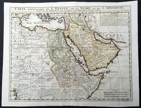
1719 Chatelain Large Old, Antique Map of Saudi Arabia, Egypt, The Horn of Africa
- Title : Carte Particuliere De L Egypt De La Nubie et De Abyssinie
- Ref #: 50627
- Size: 22in x 17 1/2in (560m x 445m)
- Date : 1719
- Condition: (A+) Fine Condition
Description:
This large beautifully hand coloured original antique map of Saudi Arabia, Egypt and The Horn of Africa was published by Henri Abraham Chatelain in 1719, in his famousAtlas Historique.
Henri Abraham Chatelain (1684 - 1743)
was a Huguenot pastor of Parisian origins. He lived consecutively in Paris, St. Martins, London (c. 1710), the Hague (c. 1721) and Amsterdam (c. 1728).
Chatelain was a skilled artist and knew combining a wealth of historical and geographical information with delicate engraving and an uncomplicated composition. Groundbreaking for its time, this work included studies of geography, history, ethnology, heraldry, and cosmography. His maps with his elegant engraving are a superb example from the golden age of French mapmaking.The publishing firm of Chatelain, Chatelain Frères and Chatelain & Fils is recorded in Amsterdam, from around 1700-1770, with Zacharias living "op den Dam" in 1730.
Henri Abraham Chatelain, his father Zacharie Chatelain (d.1723) and Zacharie Junior (1690-1754), worked as a partnership publishing the Atlas Historique, Ou Nouvelle Introduction à L'Histoire under several different Chatelain imprints, depending on the Chatelain family partnerships at the time of publication. The atlas was published in seven volumes between 1705 and 1720, with a second edition appearing in 1732. The volumes I-IV with a Third edition and volume I with a final edition in 1739.
Henri Abraham Chatelain, whose "Atlas Historique" was one of the most expansive Dutch encyclopedias of the age. First published in 1705, Chatelain's Atlas Historique was part of an immense seven-volume encyclopedia. Although the main focus of the text was geography, the work also included a wealth of historical, political, and genealogical information. The text was compiled by Nicholas Gueudeville and Garillon with a supplement by H.P. de Limiers and the maps were engraved by Chatelain, primarily after charts by De L'Isle. The atlas was published in Amsterdam between 1705 and 1721 and was later reissued by Zacharie Chatelain between 1732 and 1739.
Atlas Historique: First published in Amsterdam from 1705 to 1720, the various volumes were updated at various times up to 1739 when the fourth edition of vol.I appeared, stated as the "dernière edition, corrigée & augmentée."
The first four volumes seem to have undergone four printings with the later printings being the most desirable as they contain the maximum number of corrections and additions. The remaining three final volumes were first issued between 1719-1720 and revised in 1732.
An ambitious and beautifully-presented work, the Atlas Historique was intended for the general public, fascinated in the early eighteenth century by the recently conquered colonies and the new discoveries. Distant countries, such as the Americas, Africa, the Middle East, Mongolia, China, Japan, Indonesia, etc., take an important place in this work.
In addition to the maps, many of which are based on Guillaume De L'Isle, the plates are after the best travel accounts of the period, such as those of Dapper, Chardin, de Bruyn, Le Hay and other.
Other sections deal with the history of the european countries, and covers a wide range of subjects including genealogy, history, cosmography, topography, heraldry and chronology, costume of the world, all illustrated with numerous engraved maps, plates of local inhabitants and heraldic charts of the lineages of the ruling families of the time. The maps, prints and tables required to make up a complete set are listed in detail in each volume.
The accompanying text is in French and often is printed in two columns on the page with maps and other illustrations interspersed. Each map and table is numbered consecutively within its volume and all maps bear the privileges of the States of Holland and West-Friesland.
The encyclopaedic nature of the work as a whole is reflected in this six frontispiece. The pages are the work of the celerated mr. Romeijn de Hooghe. and are engraved by J.Goeree, T.Schynyoet and P.Sluyter.
New scholarship has suggested the compiler of the atlas, who is identified on the title as "Mr. C***" not to be Henri Abraham Châtelain, but Zacharie Châtelain. (See Van Waning's article in the Journal of the International Map Collectors' Society for persuasive evidence of the latter's authorship.) (Ref: M&B; Tooley)
General Description:
Paper thickness and quality: - Heavy and stable
Paper color: - White
Age of map color: - Later
Colors used: - Pink, green, yellow, blue
General color appearance: - Authentic
Paper size: - 22in x 17 1/2in (560m x 445m)
Plate size: - 21 1/2in x 16in (545m x 405mm)
Margins: - min. 1in (25mm)
Imperfections:
Margins: - None
Plate area: - None
Verso: - None
1719 Chatelain Very Large Genealogy Chart of the Royal Families of Europe
-
Title : Nouvelle carte généalogique des principaux souverains de l'Europe issus de la famille ROYALE DE FRANCE et les branches des maisons souveraines de l'Europe issues de WITEKIND LE GRAND ou des anciens RO
(Translation...New genealogical map of the main rulers of Europe from the French Royal family and branches of sovereign houses from Europe)
- Ref #: 50688
- Size: 43 1/2in x 18 1/2in (1.09m x 470m)
- Date : 1719
- Condition: (A+) Fine Condition
Description:
This large finely engraved original antique genealogy chart of the Royal families of France and wider Europe was published by Henri Abraham Chatelain in 1719, in his famous Atlas Historique.
This very large chart illustrates the relationship between the French Royal families to also Denmark, Germany & German States, Prussia, Sweden and others.
Henri Abraham Chatelain (1684 - 1743)
was a Huguenot pastor of Parisian origins. He lived consecutively in Paris, St. Martins, London (c. 1710), the Hague (c. 1721) and Amsterdam (c. 1728).
Chatelain was a skilled artist and knew combining a wealth of historical and geographical information with delicate engraving and an uncomplicated composition. Groundbreaking for its time, this work included studies of geography, history, ethnology, heraldry, and cosmography. His maps with his elegant engraving are a superb example from the golden age of French mapmaking.The publishing firm of Chatelain, Chatelain Frères and Chatelain & Fils is recorded in Amsterdam, from around 1700-1770, with Zacharias living "op den Dam" in 1730.
Henri Abraham Chatelain, his father Zacharie Chatelain (d.1723) and Zacharie Junior (1690-1754), worked as a partnership publishing the Atlas Historique, Ou Nouvelle Introduction à L'Histoire under several different Chatelain imprints, depending on the Chatelain family partnerships at the time of publication. The atlas was published in seven volumes between 1705 and 1720, with a second edition appearing in 1732. The volumes I-IV with a Third edition and volume I with a final edition in 1739.
Henri Abraham Chatelain, whose "Atlas Historique" was one of the most expansive Dutch encyclopedias of the age. First published in 1705, Chatelain's Atlas Historique was part of an immense seven-volume encyclopedia. Although the main focus of the text was geography, the work also included a wealth of historical, political, and genealogical information. The text was compiled by Nicholas Gueudeville and Garillon with a supplement by H.P. de Limiers and the maps were engraved by Chatelain, primarily after charts by De L'Isle. The atlas was published in Amsterdam between 1705 and 1721 and was later reissued by Zacharie Chatelain between 1732 and 1739.
Atlas Historique: First published in Amsterdam from 1705 to 1720, the various volumes were updated at various times up to 1739 when the fourth edition of vol.I appeared, stated as the "dernière edition, corrigée & augmentée."
The first four volumes seem to have undergone four printings with the later printings being the most desirable as they contain the maximum number of corrections and additions. The remaining three final volumes were first issued between 1719-1720 and revised in 1732.
An ambitious and beautifully-presented work, the Atlas Historique was intended for the general public, fascinated in the early eighteenth century by the recently conquered colonies and the new discoveries. Distant countries, such as the Americas, Africa, the Middle East, Mongolia, China, Japan, Indonesia, etc., take an important place in this work.
In addition to the maps, many of which are based on Guillaume De L'Isle, the plates are after the best travel accounts of the period, such as those of Dapper, Chardin, de Bruyn, Le Hay and other.
Other sections deal with the history of the european countries, and covers a wide range of subjects including genealogy, history, cosmography, topography, heraldry and chronology, costume of the world, all illustrated with numerous engraved maps, plates of local inhabitants and heraldic charts of the lineages of the ruling families of the time. The maps, prints and tables required to make up a complete set are listed in detail in each volume.
The accompanying text is in French and often is printed in two columns on the page with maps and other illustrations interspersed. Each map and table is numbered consecutively within its volume and all maps bear the privileges of the States of Holland and West-Friesland.
The encyclopaedic nature of the work as a whole is reflected in this six frontispiece. The pages are the work of the celerated mr. Romeijn de Hooghe. and are engraved by J.Goeree, T.Schynyoet and P.Sluyter.
New scholarship has suggested the compiler of the atlas, who is identified on the title as "Mr. C***" not to be Henri Abraham Châtelain, but Zacharie Châtelain. (See Van Waning's article in the Journal of the International Map Collectors' Society for persuasive evidence of the latter's authorship.) (Ref: M&B; Tooley)
General Description:
Paper thickness and quality: - Heavy and stable
Paper color: - White
Age of map color: -
Colors used: -
General color appearance: -
Paper size: - 43 1/2in x 18 1/2in (1.09m x 470m)
Plate size: - 43in x 17in (1.07m x 435mm)
Margins: - min. 1/4in (2mm)
Imperfections:
Margins: - Right margin cropped to plate-mark, age toning to right margin
Plate area: - None
Verso: - None
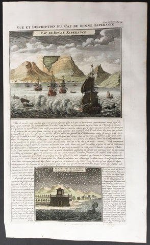
1719 Chatelain View of Cape Town, Table Top Mountain South Africa
- Title : Vue et Description Du Cap De Bonne Esperance
- Ref : 50640
- Size: 17 1/2in x 10 1/2in (440mm x 265mm)
- Date : 1719
- Condition: (A+) Fine Condition
Description:
An exceptional hand coloured original antique page of Abraham Chatelain's 1719 striking view of the Cape of Good Hope, with Dutch ships in the harbour and Table Mountain in the background.
Separating the two views is an engraved descriptive text which refers mainly to the Company’s gardens, ‘the most beautiful and curious to be seen in a country that is sterile and frightful.’
The lower engraving shows the Dutch fort at the Cape and an observatory established by the Frenchman Tachard and the Jesuit Fathers to observe the southern skies.
Background:
The first Europeans to discover the Cape were the Portuguese, with Bartholomeu Dias arriving in 1488 after journeying south along the west coast of Africa. The next recorded European sighting of the Cape was by Vasco da Gama in 1497 while he was searching for a route that would lead directly from Europe to Asia. Table Mountain was given its name in 1503 by António de Saldanha, a Portuguese admiral and explorer. He called it Taboa da caba ("table of the cape"). The name given to the mountain by the Khoi inhabitants was Hoeri 'kwaggo ("sea mountain")
The area fell out of regular contact with Europeans until 1652, when Jan van Riebeeck and other employees of the Dutch East India Company (Dutch: Vereenigde Oost-Indische Compagnie, or simply VOC) were sent to the Cape to establish a halfway station to provide fresh water, vegetables, and meat for passing ships travelling to and from Asia. Van Riebeeck's party of three vessels landed at the cape on 6 April 1652. The group quickly erected shelters and laid out vegetable gardens and orchards, and are preserved in the Company Gardens. Water from the Fresh River, which descended from Table Mountain, was channelled into canals to provide irrigation. The settlers bartered with the native Khoisan for their sheep and cattle. Forests in Hout Bay and the southern and eastern flanks of Table Mountain provided timber for ships and houses. At this point, the VOC had a monopoly on trade and prohibited any private trade. The Dutch gave their own names to the native inhabitants that they encountered, calling the pastoralists "Hottentots," those that lived on the coast and subsisted on shellfishing," and those who were hunter-gatherers were named "Bushmen."
The first wave of Asian immigration to South Africa started in 1654. These first immigrants were banished to the Cape by the Dutch Batavian High Court. These Asians helped to form the foundation of the Cape Coloured and Cape Malay populations, as well as bringing Islam to the Cape. The first large territorial expansion occurred in 1657, when farms were granted by the VOC to a few servants in an attempt to increase food production. These farms were situated along the Liesbeeck River and the VOC still retained financial control of them. The first slaves were brought to the Cape from Java and Madagascar in the following year to work on the farms. The first of a long series of border conflicts between the inhabitants in the European-controlled area and native inhabitants began in 1658 when settlers clashed with the Khoi, who realised that they were losing territory.
Work on the Castle of Good Hope, the first permanent European fortification in the area, began in 1666. The new castle replaced the previous wooden fort that Van Riebeeck and his men built. Finally completed in 1679, the castle is the oldest building in South Africa.
Simon van der Stel, after whom the town of Stellenbosch is named, arrived in 1679 to replace Van Riebeeck as governor. Van der Stel founded the Cape wine industry by bringing grape vines with him on his ship, an industry which would quickly grow to be important for the region. He also promoted territorial expansion in the Colony.
The first non-Dutch immigrants to the Cape, the Huguenots, arrived in 1688. The Huguenots had fled from anti-Protestant persecution in Catholic France to the Netherlands, where the VOC offered them free passage to the Cape as well as farmland. The Huguenots brought important experience in wine production to the Cape, greatly bolstering the industry, as well as providing strong cultural roots.
By 1754, the population of the settlement on the Cape had reached 5,510 Europeans and 6,729 slaves. But by 1780, France and Great Britain went to war against each other. The Netherlands entered the war on the French side, and thus a small garrison of French troops were sent to the Cape to protect it against the British. These troops, however, left by 1784. By 1795, however, the Netherlands was invaded by France and the VOC was in complete financial ruin. The Prince of Orange fled to England for protection, which allowed for the establishment of the Dutch Batavian Republic. Due to the long time it took to send and receive news from Europe, the Cape Commissioner of the time knew only that the French had been taking territory in the Netherlands and that the Dutch could change sides in the war at any moment. British forces arrived at the Cape bearing a letter from the Prince of Orange asking the Commissioner to allow the British troops to protect the Cape from France until the war. The British informed the Commissioner that the Prince had fled to England. The reaction in the Cape Council was mixed, and eventually the British successfully invaded the Cape in the Battle of Muizenberg. The British immediately announced the beginning of free trade.
As elsewhere in Africa and other parts of the world, trading in slaves was a significant activity. A notable event was the mutiny, in 1766, of the slaves on the slaver ship Meermin.
General Description:
Paper thickness and quality: - Heavy and stable
Paper color: - White
Age of map color: - Later
Colors used: - Pink, green, yellow, blue
General color appearance: - Authentic
Paper size: - 17 1/2in x 10 1/2in (440mm x 265mm)
Margins: - min. 1/2in (12mm)
Imperfections:
Margins: - None
Plate area: - None
Verso: - None
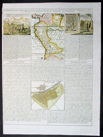
1719 Chatelian Antique Map & Plan Lima, Peru, Colombia
- Title : Carte Particuliere Du Perou...
- Ref #: 60558
- Size: 21in x 17in (535mm x 430m)
- Date : 1719
- Condition: (A+) Fine Condition
Description:
This finely engraved hand coloured original antique map, view & plan of Lima, Peru, Colombia and central South America was published as part of Henri AbrahamChatelain's 1719 edition of Atlas Historique.
As with all Chatelain's maps & views this is finely engraved with a large amount of topographical, political and historical detail.
The Atlas Historique published by Henri Chatelain was part of a major work of its time, an encyclopedia in seven volumes, including geography as one of its main subjects. The text was by Nicholas Gueudeville and the maps by Chatelain. The Atlas included one of the finest map of America (four sheets) surrounded by vignettes and decorative insets.The Atlas Historique was completed between 1705 and 1720, further issues were published up to 1739. The series was published in Amsterdam, with Chatelain’s maps based on those of G. Delisle. (Ref: M&B; Tooley)
General Description:
Paper thickness and quality: - Heavy and stable
Paper color: - White
Age of map color: - later
Colors used: - Yellow, green, blue, pink
General color appearance: - Authentic
Paper size: - 21in x 17in (535mm x 430m)
Plate size: - 19 1/2in x 15in (490mm x 380mm)
Margins: - min. 1in (25mm)
Imperfections:
Margins: - None
Plate area: - None
Verso: - None