Prints (424)
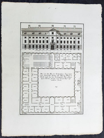
1740 Wolff & Corvinus Antique Arch Print of a Poorhouse near Stralau Gate Berlin
- Title : Das von dem H. von Grünenberg Seel. inventirte sogenandte Armen- oder Waysen-Hauss zu Berlin, nache bey dem Stralauischen Thor gelegen, ....
- Ref #: 93455
- Size: 19in x 12 1/2in (490mm x 335mm)
- Date : 1740
- Condition: (A+) Fine Condition
Description:
This large rare, original copper-plate engraved antique architectural print of the Poorhouse near the old Stralau Gate (Stralauer Tor) in Berlin - plate No. 8 of 16 - by Johann August Corvinus 1683 - 1738, after Andreas Mayers 1716 - 1782, was published in Eigentliche Abbildung des Prächtigen Königl. Lust Schlosses Charlottenburg, eine Meile von Berlin, sambt dem darhinden im Walde gelegenen schönen Lust Garten
(Set of 16 numbered plates, the first with the title, with plans and views of the buildings and gardens at Charlottenburg, the palace of the King of Prussia on the outskirts of Berlin.) by Jeremias Wolff Erben in 1740.
General Definitions:
Paper thickness and quality: - Heavy and stable
Paper color : - off white
Age of map color: -
Colors used: -
General color appearance: -
Paper size: - 19in x 12 1/2in (490mm x 335mm)
Plate size: - 14 1/2in x 10 1/2in (370mm x 260mm)
Margins: - Min 1in (25mm)
Imperfections:
Margins: - None
Plate area: - None
Verso: - None
Background:
Berlin straddles the banks of the River Spree, which flows into the River Havel (a tributary of the River Elbe) in the western borough of Spandau. Among the citys main topographical features are the many lakes in the western and southeastern boroughs formed by the Spree, Havel, and Dahme rivers (the largest of which is Lake Müggelsee). Due to its location in the European Plain, Berlin is influenced by a temperate seasonal climate. About one-third of the citys area is composed of forests, parks, gardens, rivers, canals and lakes. The city lies in the Central German dialect area, the Berlin dialect being a variant of the Lusatian-New Marchian dialects.
First documented in the 13th century and situated at the crossing of two important historic trade routes, Berlin became the capital of the Margraviate of Brandenburg (1417–1701), the Kingdom of Prussia (1701–1918), the German Empire (1871–1918), the Weimar Republic (1919–1933), and the Third Reich (1933–1945). Berlin in the 1920s was the third-largest municipality in the world. After World War II and its subsequent occupation by the victorious countries, the city was divided; West Berlin became a de facto West German exclave, surrounded by the Berlin Wall (1961–1989) and East German territory. East Berlin was declared capital of East Germany, while Bonn became the West German capital. Following German reunification in 1990, Berlin once again became the capital of all of Germany.
The Thirty Years War between 1618 and 1648 devastated Berlin. One third of its houses were damaged or destroyed, and the city lost half of its population. Frederick William, known as the Great Elector, who had succeeded his father George William as ruler in 1640, initiated a policy of promoting immigration and religious tolerance. With the Edict of Potsdam in 1685, Frederick William offered asylum to the French Huguenots.
By 1700, approximately 30 percent of Berlins residents were French, because of the Huguenot immigration. Many other immigrants came from Bohemia, Poland, and Salzburg.
Since 1618, the Margraviate of Brandenburg had been in personal union with the Duchy of Prussia. In 1701, the dual state formed the Kingdom of Prussia, as Frederick III, Elector of Brandenburg, crowned himself as king Frederick I in Prussia. Berlin became the capital of the new Kingdom, replacing Königsberg. This was a successful attempt to centralise the capital in the very far-flung state, and it was the first time the city began to grow. In 1709, Berlin merged with the four cities of Cölln, Friedrichswerder, Friedrichstadt and Dorotheenstadt under the name Berlin, Haupt- und Residenzstadt Berlin.
In 1740, Frederick II, known as Frederick the Great (1740–1786), came to power. Under the rule of Frederick II, Berlin became a center of the Enlightenment, but also, was briefly occupied during the Seven Years War by the Russian army. Following Frances victory in the War of the Fourth Coalition, Napoleon Bonaparte marched into Berlin in 1806, but granted self-government to the city. In 1815, the city became part of the new Province of Brandenburg.
The Industrial Revolution transformed Berlin during the 19th century; the citys economy and population expanded dramatically, and it became the main railway hub and economic centre of Germany. Additional suburbs soon developed and increased the area and population of Berlin. In 1861, neighbouring suburbs including Wedding, Moabit and several others were incorporated into Berlin. In 1871, Berlin became capital of the newly founded German Empire. In 1881, it became a city district separate from Brandenburg.
Wolff, Jeremais 1663 - 1724
Wolff was an German engraver and publisher. Born in Augsburg, he originally trained as a clock and automat maker, later changing course and opening a small copperplate engraving shop. His success was impressive and became one of the largest European art, print & map publishers in the first half of the 18th century. Wolff employed some of the best engravers of the time and although not an engraver himself, only Wolffs name was recorded on the engravings. Many of his engravers went uncredited for their work. In 1710 Wolff was one of the founder member of the Empire State Academy of Arts in Augsburg.
After his death in 1724, Wolffs publishing business was inherited by his sons and son-in-law, Johann Balthasar Probst (1673–1750) a notable engraver at the time. The firm continued on in Augsburg under the name Jeremias Wolff Erben.
Together with the Nuremberg copperplate engraver Paul Decker , Wolff published a series of engravings showing the war successes of Prince Eugene of Savoy in Italy , southern Germany and the Spanish Netherlands, during the War of the Spanish Succession . The prints are exhibited in the Museum of Military History, in Vienna .
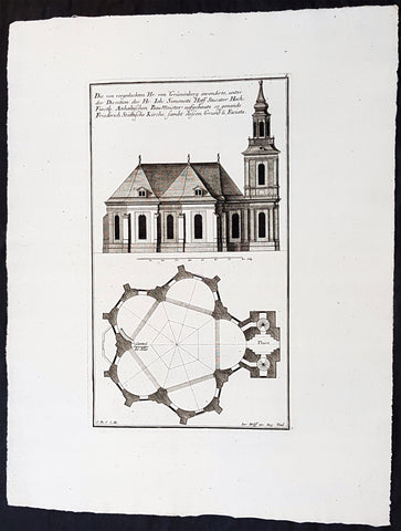
1740 Wolff & Corvinus Antique Arch. Print Jerusalem Church Friedrichstadt.Berlin
- Title : Die von vorgedachten Hr. von Grünenberg invendierte, unter der Direction des Hr. Ioh. Simonetti Hoff Stucator Hoch-Fürstl. Anhaltischen BauMeister aufgebaute so genande Friderich Stättische Kirche sampt dessen Grund u. Faciata.
- Ref #: 93458
- Size: 19in x 12 1/2in (490mm x 335mm)
- Date : 1740
- Condition: (A+) Fine Condition
Description:
This large rare, original copper-plate engraved antique architectural print of the Parochialkirche (literally the Reformed parochial church) in the Mitte suburb of Berlin - plate No. 7 of 16 - by Johann August Corvinus 1683 - 1738, after Andreas Mayers 1716 - 1782, was published in Eigentliche Abbildung des Prächtigen Königl. Lust Schlosses Charlottenburg, eine Meile von Berlin, sambt dem darhinden im Walde gelegenen schönen Lust Garten
(Set of 16 numbered plates, the first with the title, with plans and views of the buildings and gardens at Charlottenburg, the palace of the King of Prussia on the outskirts of Berlin.) by Jeremias Wolff Erben in 1740.
General Definitions:
Paper thickness and quality: - Heavy and stable
Paper color : - off white
Age of map color: -
Colors used: -
General color appearance: -
Paper size: - 19in x 12 1/2in (490mm x 335mm)
Plate size: - 14 1/2in x 10 1/2in (370mm x 260mm)
Margins: - Min 1in (25mm)
Imperfections:
Margins: - None
Plate area: - None
Verso: - None
Background:
Berlin straddles the banks of the River Spree, which flows into the River Havel (a tributary of the River Elbe) in the western borough of Spandau. Among the citys main topographical features are the many lakes in the western and southeastern boroughs formed by the Spree, Havel, and Dahme rivers (the largest of which is Lake Müggelsee). Due to its location in the European Plain, Berlin is influenced by a temperate seasonal climate. About one-third of the citys area is composed of forests, parks, gardens, rivers, canals and lakes. The city lies in the Central German dialect area, the Berlin dialect being a variant of the Lusatian-New Marchian dialects.
First documented in the 13th century and situated at the crossing of two important historic trade routes, Berlin became the capital of the Margraviate of Brandenburg (1417–1701), the Kingdom of Prussia (1701–1918), the German Empire (1871–1918), the Weimar Republic (1919–1933), and the Third Reich (1933–1945). Berlin in the 1920s was the third-largest municipality in the world. After World War II and its subsequent occupation by the victorious countries, the city was divided; West Berlin became a de facto West German exclave, surrounded by the Berlin Wall (1961–1989) and East German territory. East Berlin was declared capital of East Germany, while Bonn became the West German capital. Following German reunification in 1990, Berlin once again became the capital of all of Germany.
The Thirty Years War between 1618 and 1648 devastated Berlin. One third of its houses were damaged or destroyed, and the city lost half of its population. Frederick William, known as the Great Elector, who had succeeded his father George William as ruler in 1640, initiated a policy of promoting immigration and religious tolerance. With the Edict of Potsdam in 1685, Frederick William offered asylum to the French Huguenots.
By 1700, approximately 30 percent of Berlins residents were French, because of the Huguenot immigration. Many other immigrants came from Bohemia, Poland, and Salzburg.
Since 1618, the Margraviate of Brandenburg had been in personal union with the Duchy of Prussia. In 1701, the dual state formed the Kingdom of Prussia, as Frederick III, Elector of Brandenburg, crowned himself as king Frederick I in Prussia. Berlin became the capital of the new Kingdom, replacing Königsberg. This was a successful attempt to centralise the capital in the very far-flung state, and it was the first time the city began to grow. In 1709, Berlin merged with the four cities of Cölln, Friedrichswerder, Friedrichstadt and Dorotheenstadt under the name Berlin, Haupt- und Residenzstadt Berlin.
In 1740, Frederick II, known as Frederick the Great (1740–1786), came to power. Under the rule of Frederick II, Berlin became a center of the Enlightenment, but also, was briefly occupied during the Seven Years War by the Russian army. Following Frances victory in the War of the Fourth Coalition, Napoleon Bonaparte marched into Berlin in 1806, but granted self-government to the city. In 1815, the city became part of the new Province of Brandenburg.
The Industrial Revolution transformed Berlin during the 19th century; the citys economy and population expanded dramatically, and it became the main railway hub and economic centre of Germany. Additional suburbs soon developed and increased the area and population of Berlin. In 1861, neighbouring suburbs including Wedding, Moabit and several others were incorporated into Berlin. In 1871, Berlin became capital of the newly founded German Empire. In 1881, it became a city district separate from Brandenburg.
Wolff, Jeremais 1663 - 1724
Wolff was an German engraver and publisher. Born in Augsburg, he originally trained as a clock and automat maker, later changing course and opening a small copperplate engraving shop. His success was impressive and became one of the largest European art, print & map publishers in the first half of the 18th century. Wolff employed some of the best engravers of the time and although not an engraver himself, only Wolffs name was recorded on the engravings. Many of his engravers went uncredited for their work. In 1710 Wolff was one of the founder member of the Empire State Academy of Arts in Augsburg.
After his death in 1724, Wolffs publishing business was inherited by his sons and son-in-law, Johann Balthasar Probst (1673–1750) a notable engraver at the time. The firm continued on in Augsburg under the name Jeremias Wolff Erben.
Together with the Nuremberg copperplate engraver Paul Decker , Wolff published a series of engravings showing the war successes of Prince Eugene of Savoy in Italy , southern Germany and the Spanish Netherlands, during the War of the Spanish Succession . The prints are exhibited in the Museum of Military History, in Vienna .
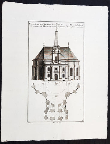
1740 Wolff & Corvinus Antique Arch. Print of the Parochialkirche in Mitte Berlin
- Title : Vordere faciata nebst dem halben Grund Riß der vorigen Parochial-Kirche mit verändertem Thurn wie solcher dermahlen sich würklich presentiert. Frontriß, darunter der halbe Grundriß.
- Ref #: 93459
- Size: 19in x 12 1/2in (490mm x 335mm)
- Date : 1740
- Condition: (A+) Fine Condition
Description:
This large rare, original copper-plate engraved antique architectural print of the Parochialkirche (literally the Reformed parochial church) in the Mitte suburb of Berlin - plate No. 6 of 16 - by Johann August Corvinus 1683 - 1738, after Andreas Mayers 1716 - 1782, was published in Eigentliche Abbildung des Prächtigen Königl. Lust Schlosses Charlottenburg, eine Meile von Berlin, sambt dem darhinden im Walde gelegenen schönen Lust Garten.
(Set of 16 numbered plates, the first with the title, with plans and views of the buildings and gardens at Charlottenburg, the palace of the King of Prussia on the outskirts of Berlin.) by Jeremias Wolff Erben in 1740.
General Definitions:
Paper thickness and quality: - Heavy and stable
Paper color : - off white
Age of map color: -
Colors used: -
General color appearance: -
Paper size: - 19in x 12 1/2in (490mm x 335mm)
Plate size: - 14 1/2in x 10 1/2in (370mm x 260mm)
Margins: - Min 1in (25mm)
Imperfections:
Margins: - None
Plate area: - None
Verso: - None
Background:
Berlin straddles the banks of the River Spree, which flows into the River Havel (a tributary of the River Elbe) in the western borough of Spandau. Among the citys main topographical features are the many lakes in the western and southeastern boroughs formed by the Spree, Havel, and Dahme rivers (the largest of which is Lake Müggelsee). Due to its location in the European Plain, Berlin is influenced by a temperate seasonal climate. About one-third of the citys area is composed of forests, parks, gardens, rivers, canals and lakes. The city lies in the Central German dialect area, the Berlin dialect being a variant of the Lusatian-New Marchian dialects.
First documented in the 13th century and situated at the crossing of two important historic trade routes, Berlin became the capital of the Margraviate of Brandenburg (1417–1701), the Kingdom of Prussia (1701–1918), the German Empire (1871–1918), the Weimar Republic (1919–1933), and the Third Reich (1933–1945). Berlin in the 1920s was the third-largest municipality in the world. After World War II and its subsequent occupation by the victorious countries, the city was divided; West Berlin became a de facto West German exclave, surrounded by the Berlin Wall (1961–1989) and East German territory. East Berlin was declared capital of East Germany, while Bonn became the West German capital. Following German reunification in 1990, Berlin once again became the capital of all of Germany.
The Thirty Years War between 1618 and 1648 devastated Berlin. One third of its houses were damaged or destroyed, and the city lost half of its population. Frederick William, known as the Great Elector, who had succeeded his father George William as ruler in 1640, initiated a policy of promoting immigration and religious tolerance. With the Edict of Potsdam in 1685, Frederick William offered asylum to the French Huguenots.
By 1700, approximately 30 percent of Berlins residents were French, because of the Huguenot immigration. Many other immigrants came from Bohemia, Poland, and Salzburg.
Since 1618, the Margraviate of Brandenburg had been in personal union with the Duchy of Prussia. In 1701, the dual state formed the Kingdom of Prussia, as Frederick III, Elector of Brandenburg, crowned himself as king Frederick I in Prussia. Berlin became the capital of the new Kingdom, replacing Königsberg. This was a successful attempt to centralise the capital in the very far-flung state, and it was the first time the city began to grow. In 1709, Berlin merged with the four cities of Cölln, Friedrichswerder, Friedrichstadt and Dorotheenstadt under the name Berlin, Haupt- und Residenzstadt Berlin.
In 1740, Frederick II, known as Frederick the Great (1740–1786), came to power. Under the rule of Frederick II, Berlin became a center of the Enlightenment, but also, was briefly occupied during the Seven Years War by the Russian army. Following Frances victory in the War of the Fourth Coalition, Napoleon Bonaparte marched into Berlin in 1806, but granted self-government to the city. In 1815, the city became part of the new Province of Brandenburg.
The Industrial Revolution transformed Berlin during the 19th century; the citys economy and population expanded dramatically, and it became the main railway hub and economic centre of Germany. Additional suburbs soon developed and increased the area and population of Berlin. In 1861, neighbouring suburbs including Wedding, Moabit and several others were incorporated into Berlin. In 1871, Berlin became capital of the newly founded German Empire. In 1881, it became a city district separate from Brandenburg.
Wolff, Jeremais 1663 - 1724
Wolff was an German engraver and publisher. Born in Augsburg, he originally trained as a clock and automat maker, later changing course and opening a small copperplate engraving shop. His success was impressive and became one of the largest European art, print & map publishers in the first half of the 18th century. Wolff employed some of the best engravers of the time and although not an engraver himself, only Wolffs name was recorded on the engravings. Many of his engravers went uncredited for their work. In 1710 Wolff was one of the founder member of the Empire State Academy of Arts in Augsburg.
After his death in 1724, Wolffs publishing business was inherited by his sons and son-in-law, Johann Balthasar Probst (1673–1750) a notable engraver at the time. The firm continued on in Augsburg under the name Jeremias Wolff Erben.
Together with the Nuremberg copperplate engraver Paul Decker , Wolff published a series of engravings showing the war successes of Prince Eugene of Savoy in Italy , southern Germany and the Spanish Netherlands, during the War of the Spanish Succession . The prints are exhibited in the Museum of Military History, in Vienna .
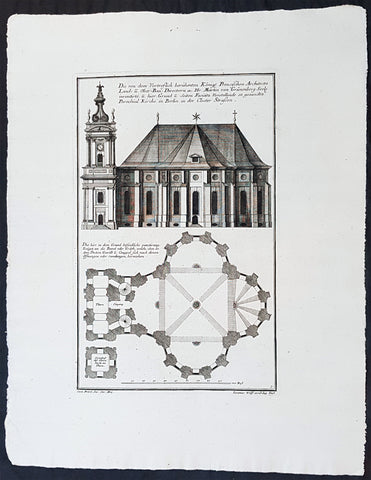
1740 Wolff & Corvinus Antique Architectural Print Parochialkirche, Mitte, Berlin
- Title : Die Von dem Vortreslich beruhmten Konigl. Preusichen Architect Land u. Ober Bau Directorn etc. Hr. Martin von Grunenberg Seel. inventirte, u. hier Grund u. Seiten Faciata Vorstellende so genandte Parochial Kirche in Berlin in der Closter Strassen
- Ref #: 93451
- Size: 19in x 12 1/2in (490mm x 335mm)
- Date : 1740
- Condition: (A+) Fine Condition
Description:
This large rare, original copper-plate engraved antique architectural print of the Parochialkirche (literally the Reformed parochial church) in the Mitte suburb of Berlin - plate No. 5 of 16 - by Johann August Corvinus 1683 - 1738, after Andreas Mayers 1716 - 1782, was published in Eigentliche Abbildung des Prächtigen Königl. Lust Schlosses Charlottenburg, eine Meile von Berlin, sambt dem darhinden im Walde gelegenen schönen Lust Garten
(Set of 16 numbered plates, the first with the title, with plans and views of the buildings and gardens at Charlottenburg, the palace of the King of Prussia on the outskirts of Berlin.) by Jeremias Wolff Erben in 1740.
General Definitions:
Paper thickness and quality: - Heavy and stable
Paper color : - off white
Age of map color: -
Colors used: -
General color appearance: -
Paper size: - 19in x 12 1/2in (490mm x 335mm)
Plate size: - 14 1/2in x 10 1/2in (370mm x 260mm)
Margins: - Min 1in (25mm)
Imperfections:
Margins: - None
Plate area: - None
Verso: - None
Background:
Berlin straddles the banks of the River Spree, which flows into the River Havel (a tributary of the River Elbe) in the western borough of Spandau. Among the citys main topographical features are the many lakes in the western and southeastern boroughs formed by the Spree, Havel, and Dahme rivers (the largest of which is Lake Müggelsee). Due to its location in the European Plain, Berlin is influenced by a temperate seasonal climate. About one-third of the citys area is composed of forests, parks, gardens, rivers, canals and lakes. The city lies in the Central German dialect area, the Berlin dialect being a variant of the Lusatian-New Marchian dialects.
First documented in the 13th century and situated at the crossing of two important historic trade routes, Berlin became the capital of the Margraviate of Brandenburg (1417–1701), the Kingdom of Prussia (1701–1918), the German Empire (1871–1918), the Weimar Republic (1919–1933), and the Third Reich (1933–1945). Berlin in the 1920s was the third-largest municipality in the world. After World War II and its subsequent occupation by the victorious countries, the city was divided; West Berlin became a de facto West German exclave, surrounded by the Berlin Wall (1961–1989) and East German territory. East Berlin was declared capital of East Germany, while Bonn became the West German capital. Following German reunification in 1990, Berlin once again became the capital of all of Germany.
The Thirty Years War between 1618 and 1648 devastated Berlin. One third of its houses were damaged or destroyed, and the city lost half of its population. Frederick William, known as the Great Elector, who had succeeded his father George William as ruler in 1640, initiated a policy of promoting immigration and religious tolerance. With the Edict of Potsdam in 1685, Frederick William offered asylum to the French Huguenots.
By 1700, approximately 30 percent of Berlins residents were French, because of the Huguenot immigration. Many other immigrants came from Bohemia, Poland, and Salzburg.
Since 1618, the Margraviate of Brandenburg had been in personal union with the Duchy of Prussia. In 1701, the dual state formed the Kingdom of Prussia, as Frederick III, Elector of Brandenburg, crowned himself as king Frederick I in Prussia. Berlin became the capital of the new Kingdom, replacing Königsberg. This was a successful attempt to centralise the capital in the very far-flung state, and it was the first time the city began to grow. In 1709, Berlin merged with the four cities of Cölln, Friedrichswerder, Friedrichstadt and Dorotheenstadt under the name Berlin, Haupt- und Residenzstadt Berlin.
In 1740, Frederick II, known as Frederick the Great (1740–1786), came to power. Under the rule of Frederick II, Berlin became a center of the Enlightenment, but also, was briefly occupied during the Seven Years War by the Russian army. Following Frances victory in the War of the Fourth Coalition, Napoleon Bonaparte marched into Berlin in 1806, but granted self-government to the city. In 1815, the city became part of the new Province of Brandenburg.
The Industrial Revolution transformed Berlin during the 19th century; the citys economy and population expanded dramatically, and it became the main railway hub and economic centre of Germany. Additional suburbs soon developed and increased the area and population of Berlin. In 1861, neighbouring suburbs including Wedding, Moabit and several others were incorporated into Berlin. In 1871, Berlin became capital of the newly founded German Empire. In 1881, it became a city district separate from Brandenburg.
Wolff, Jeremais 1663 - 1724
Wolff was an German engraver and publisher. Born in Augsburg, he originally trained as a clock and automat maker, later changing course and opening a small copperplate engraving shop. His success was impressive and became one of the largest European art, print & map publishers in the first half of the 18th century. Wolff employed some of the best engravers of the time and although not an engraver himself, only Wolffs name was recorded on the engravings. Many of his engravers went uncredited for their work. In 1710 Wolff was one of the founder member of the Empire State Academy of Arts in Augsburg.
After his death in 1724, Wolffs publishing business was inherited by his sons and son-in-law, Johann Balthasar Probst (1673–1750) a notable engraver at the time. The firm continued on in Augsburg under the name Jeremias Wolff Erben.
Together with the Nuremberg copperplate engraver Paul Decker , Wolff published a series of engravings showing the war successes of Prince Eugene of Savoy in Italy , southern Germany and the Spanish Netherlands, during the War of the Spanish Succession . The prints are exhibited in the Museum of Military History, in Vienna .
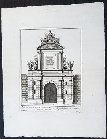
1740 Wolff & Corvinus Antique Architectural Print of Berlin Gate, Leipziger Tor
- Title : Das von dem Herrn Baumeister Nering Seel. ausgefuhrte so genandte Leipziger Statt Thor in Berlin
- Ref #: 93452
- Size: 19in x 12 1/2in (490mm x 335mm)
- Date : 1740
- Condition: (A+) Fine Condition
Description:
This large fine, original copper-plate engraved antique architectural print of buildings & gardens in 17th & 18th century Berlin - plate No. 3 of 16 - by Johann August Corvinus 1683 - 1738, after Andreas Mayers 1716 - 1782, was published in Eigentliche Abbildung des Prächtigen Königl. Lust Schlosses Charlottenburg, eine Meile von Berlin, sambt dem darhinden im Walde gelegenen schönen Lust Garten
(Set of 16 numbered plates, the first with the title, with plans and views of the buildings and gardens at Charlottenburg, the palace of the King of Prussia on the outskirts of Berlin.) by Jeremias Wolff Erben in 1740.
General Definitions:
Paper thickness and quality: - Heavy and stable
Paper color : - off white
Age of map color: -
Colors used: -
General color appearance: -
Paper size: - 19in x 12 1/2in (490mm x 335mm)
Plate size: - 14 1/2in x 10 1/2in (370mm x 260mm)
Margins: - Min 1in (25mm)
Imperfections:
Margins: - None
Plate area: - None
Verso: - None
Background:
Berlin straddles the banks of the River Spree, which flows into the River Havel (a tributary of the River Elbe) in the western borough of Spandau. Among the citys main topographical features are the many lakes in the western and southeastern boroughs formed by the Spree, Havel, and Dahme rivers (the largest of which is Lake Müggelsee). Due to its location in the European Plain, Berlin is influenced by a temperate seasonal climate. About one-third of the citys area is composed of forests, parks, gardens, rivers, canals and lakes. The city lies in the Central German dialect area, the Berlin dialect being a variant of the Lusatian-New Marchian dialects.
First documented in the 13th century and situated at the crossing of two important historic trade routes, Berlin became the capital of the Margraviate of Brandenburg (1417–1701), the Kingdom of Prussia (1701–1918), the German Empire (1871–1918), the Weimar Republic (1919–1933), and the Third Reich (1933–1945). Berlin in the 1920s was the third-largest municipality in the world. After World War II and its subsequent occupation by the victorious countries, the city was divided; West Berlin became a de facto West German exclave, surrounded by the Berlin Wall (1961–1989) and East German territory. East Berlin was declared capital of East Germany, while Bonn became the West German capital. Following German reunification in 1990, Berlin once again became the capital of all of Germany.
The Thirty Years War between 1618 and 1648 devastated Berlin. One third of its houses were damaged or destroyed, and the city lost half of its population. Frederick William, known as the Great Elector, who had succeeded his father George William as ruler in 1640, initiated a policy of promoting immigration and religious tolerance. With the Edict of Potsdam in 1685, Frederick William offered asylum to the French Huguenots.
By 1700, approximately 30 percent of Berlins residents were French, because of the Huguenot immigration. Many other immigrants came from Bohemia, Poland, and Salzburg.
Since 1618, the Margraviate of Brandenburg had been in personal union with the Duchy of Prussia. In 1701, the dual state formed the Kingdom of Prussia, as Frederick III, Elector of Brandenburg, crowned himself as king Frederick I in Prussia. Berlin became the capital of the new Kingdom, replacing Königsberg. This was a successful attempt to centralise the capital in the very far-flung state, and it was the first time the city began to grow. In 1709, Berlin merged with the four cities of Cölln, Friedrichswerder, Friedrichstadt and Dorotheenstadt under the name Berlin, Haupt- und Residenzstadt Berlin.
In 1740, Frederick II, known as Frederick the Great (1740–1786), came to power. Under the rule of Frederick II, Berlin became a center of the Enlightenment, but also, was briefly occupied during the Seven Years War by the Russian army. Following Frances victory in the War of the Fourth Coalition, Napoleon Bonaparte marched into Berlin in 1806, but granted self-government to the city. In 1815, the city became part of the new Province of Brandenburg.
The Industrial Revolution transformed Berlin during the 19th century; the citys economy and population expanded dramatically, and it became the main railway hub and economic centre of Germany. Additional suburbs soon developed and increased the area and population of Berlin. In 1861, neighbouring suburbs including Wedding, Moabit and several others were incorporated into Berlin. In 1871, Berlin became capital of the newly founded German Empire. In 1881, it became a city district separate from Brandenburg.
Wolff, Jeremais 1663 - 1724
Wolff was an German engraver and publisher. Born in Augsburg, he originally trained as a clock and automat maker, later changing course and opening a small copperplate engraving shop. His success was impressive and became one of the largest European art, print & map publishers in the first half of the 18th century. Wolff employed some of the best engravers of the time and although not an engraver himself, only Wolffs name was recorded on the engravings. Many of his engravers went uncredited for their work. In 1710 Wolff was one of the founder member of the Empire State Academy of Arts in Augsburg.
After his death in 1724, Wolffs publishing business was inherited by his sons and son-in-law, Johann Balthasar Probst (1673–1750) a notable engraver at the time. The firm continued on in Augsburg under the name Jeremias Wolff Erben.
Together with the Nuremberg copperplate engraver Paul Decker , Wolff published a series of engravings showing the war successes of Prince Eugene of Savoy in Italy , southern Germany and the Spanish Netherlands, during the War of the Spanish Succession . The prints are exhibited in the Museum of Military History, in Vienna .
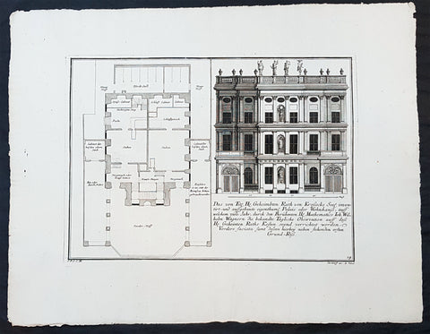
1740 Wolff & Corvinus Antique Architectural Print Buildings, Gardens Berlin - No. 14
- Title : Das von Title Hr. Geheimbten Rath von Krossecks Seel. inventirt - und aussgebaute
- Ref #: 93448
- Size: 19in x 12 1/2in (490mm x 335mm)
- Date : 1740
- Condition: (A+) Fine Condition
Description:
This large fine, original copper-plate engraved antique architectural print of buildings & gardens in the Charlottenburg suburb of Berlin & Charlottenburg Palace, - plate No. 14 of 16 - by Johann August Corvinus 1683 - 1738, after Andreas Mayers 1716 - 1782, was published in Eigentliche Abbildung des Prächtigen Königl. Lust Schlosses Charlottenburg, eine Meile von Berlin, sambt dem darhinden im Walde gelegenen schönen Lust Garten
(Set of 16 numbered plates, the first with the title, with plans and views of the buildings and gardens at Charlottenburg, the palace of the King of Prussia on the outskirts of Berlin.) by Jeremias Wolff Erben in 1740.
General Definitions:
Paper thickness and quality: - Heavy and stable
Paper color : - off white
Age of map color: -
Colors used: -
General color appearance: -
Paper size: - 19in x 12 1/2in (490mm x 335mm)
Plate size: - 14 1/2in x 10 1/2in (370mm x 260mm)
Margins: - Min 1in (25mm)
Imperfections:
Margins: - None
Plate area: - None
Verso: - None
Background:
Charlottenburg is an affluent locality of Berlin within the borough of Charlottenburg-Wilmersdorf. Established as a town in 1705 and named after late Sophia Charlotte of Hanover, Queen consort of Prussia, it is best known for Charlottenburg Palace, the largest surviving royal palace in Berlin, and the adjacent museums.
Charlottenburg is located in Berlins inner city, west of the Großer Tiergarten park. Its historic core, the former village green of Alt Lietzow, is situated on the southern shore of the Spree River running through the Berlin glacial valley. The Straße des 17. Juni road, former Charlottenburger Chaussee, which runs eastwards from Charlottenburg Gate through the Tiergarten park to Brandenburg Gate, connects Charlottenburg with the historic centre of Berlin-Mitte.
In the north and west, the Berlin Ringbahn and the Bundesautobahn 100 (Stadtring) mark the border with the Charlottenburg-Nord and Westend suburbs. Adjacent in the south is the territory of Wilmersdorf. Charlottenburg also borders on the district of Halensee in the southwest, as well as on Moabit, Hansaviertel and Tiergarten (all part of the Mitte borough) in the east and on Schöneberg in the southeast.
In 1695, Sophia Charlotte of Hanover received Lietzow from her husband, Elector Frederick III of Brandenburg, in exchange for her estates in Caputh and Langerwisch near Potsdam. Frederick had a summer residence built there for Sophie Charlotte by the architect Johann Arnold Nering between 1695 and 1699. After he had crowned himself Frederick I, King in Prussia, the Lützenburg castle was extended into a stately building with a cour dhonneur. The Swedish master builder Johann Friedrich Eosander supervised this work. Sophie Charlotte died in February 1705; shortly afterwards the settlement facing the palace was called Charlottenburg - the palace itself became Schloss Charlottenburg - and chartered as a town on April 5, 1705. The king served as the towns mayor until the historic village of Lietzow was incorporated into Charlottenburg in 1720.
Fredericks successor as king, Frederick William I of Prussia, rarely stayed at the palace, which depressed the small town of Charlottenburg. Frederick William even tried to revoke the towns privileges. With the coronation of his successor Frederick II in 1740 the towns significance increased, as regular celebrations again took place at the palace. Between 1740 and 1747 Georg Wenzeslaus von Knobelsdorff built the eastern New Wing as Fredericks residence. Later, Frederick II preferred the palace of Sanssouci, which he had partly designed himself.
When Frederick II died in 1786, his nephew Frederick William II succeeded him, and Charlottenburg became the favourite royal residence, and remained so for his son and successor Frederick William III (reigned 1797-1840). After the defeat of the Prussian army at Jena in 1806, the French occupied Berlin. Napoleon took over the palace, while his troops made a camp nearby. Charlottenburg became part of the new Prussian Province of Brandenburg in 1815 after the Napoleonic Wars.
In the late 18th century, Charlottenburgs development did not depend only on the crown. The town became a recreational area for the expanding city of Berlin. Its first true inn opened in the 1770s, in the street then called Berliner Straße (now Otto-Suhr-Allee), and many other inns and beer gardens were to follow, popular for weekend parties especially. Berliners seeking leisure and entertainment came by boat, by carriage and later by horse-drawn trams, above all to a large amusement park at the shore of the Spree river called Flora, that went into bankruptcy in 1904.
From the 1860s on the wealthy Bourgeoisie of Berlin discovered Charlottenburg as a residential area, among the first were Gerson von Bleichröder and Ernst Werner von Siemens, who had a villa built in the Berliner Straße in 1862. At the same time industrial companies like Siemens & Halske and Schering erected large factories in the north-east, at the border with the Moabit district of Berlin. In 1877 Charlottenburg received town privileges and until World War I saw an enormous increase of population with 100,000 inhabitants as of 1893 and a population of 306,000 in 1920, being the second largest city within the Province of Brandenburg, after Berlin. In the course of industrialization in the 19th century, much of Charlottenburg was incorporated in a network of streets laid out in the Hobrecht-Plan in an area that came to be known architecturally as the Wilhelmine Ring.
Wolff, Jeremais 1663 - 1724
Wolff was an German engraver and publisher. Born in Augsburg, he originally trained as a clock and automat maker, later changing course and opening a small copperplate engraving shop. His success was impressive and became one of the largest European art, print & map publishers in the first half of the 18th century. Wolff employed some of the best engravers of the time and although not an engraver himself, only Wolffs name was recorded on the engravings. Many of his engravers went uncredited for their work. In 1710 Wolff was one of the founder member of the Empire State Academy of Arts in Augsburg.
After his death in 1724, Wolffs publishing business was inherited by his sons and son-in-law, Johann Balthasar Probst (1673–1750) a notable engraver at the time. The firm continued on in Augsburg under the name Jeremias Wolff Erben.
Together with the Nuremberg copperplate engraver Paul Decker , Wolff published a series of engravings showing the war successes of Prince Eugene of Savoy in Italy , southern Germany and the Spanish Netherlands, during the War of the Spanish Succession . The prints are exhibited in the Museum of Military History, in Vienna .
1740 Wolff & Corvinus Antique Architectural Print Charlottenburg Palace, Gardens
- Title : Haupt Hof Grund Riss dess Marstalls...Jeremais Wolff exc Aug. Vind
- Ref #: 93446
- Size: 19in x 12 1/2in (490mm x 335mm)
- Date : 1740
- Condition: (A+) Fine Condition
Description:
This large fine, original copper-plate engraved antique architectural print of buildings in the Charlottenburg suburb of Berlin & Charlottenburg Palace, - plate No. 4 of 16 - by Johann August Corvinus 1683 - 1738, after Andreas Mayers 1716 - 1782, was published in Eigentliche Abbildung des Prächtigen Königl. Lust Schlosses Charlottenburg, eine Meile von Berlin, sambt dem darhinden im Walde gelegenen schönen Lust Garten
(Set of 16 numbered plates, the first with the title, with plans and views of the buildings and gardens at Charlottenburg, the palace of the King of Prussia on the outskirts of Berlin.) by Jeremias Wolff Erben in 1740.
General Definitions:
Paper thickness and quality: - Heavy and stable
Paper color : - off white
Age of map color: -
Colors used: -
General color appearance: -
Paper size: - 19in x 12 1/2in (490mm x 335mm)
Plate size: - 15 1/2in x 10in (385mm x 255mm)
Margins: - Min 1in (25mm)
Imperfections:
Margins: - None
Plate area: - None
Verso: - None
Background:
Charlottenburg is an affluent locality of Berlin within the borough of Charlottenburg-Wilmersdorf. Established as a town in 1705 and named after late Sophia Charlotte of Hanover, Queen consort of Prussia, it is best known for Charlottenburg Palace, the largest surviving royal palace in Berlin, and the adjacent museums.
Charlottenburg is located in Berlins inner city, west of the Großer Tiergarten park. Its historic core, the former village green of Alt Lietzow, is situated on the southern shore of the Spree River running through the Berlin glacial valley. The Straße des 17. Juni road, former Charlottenburger Chaussee, which runs eastwards from Charlottenburg Gate through the Tiergarten park to Brandenburg Gate, connects Charlottenburg with the historic centre of Berlin-Mitte.
In the north and west, the Berlin Ringbahn and the Bundesautobahn 100 (Stadtring) mark the border with the Charlottenburg-Nord and Westend suburbs. Adjacent in the south is the territory of Wilmersdorf. Charlottenburg also borders on the district of Halensee in the southwest, as well as on Moabit, Hansaviertel and Tiergarten (all part of the Mitte borough) in the east and on Schöneberg in the southeast.
In 1695, Sophia Charlotte of Hanover received Lietzow from her husband, Elector Frederick III of Brandenburg, in exchange for her estates in Caputh and Langerwisch near Potsdam. Frederick had a summer residence built there for Sophie Charlotte by the architect Johann Arnold Nering between 1695 and 1699. After he had crowned himself Frederick I, King in Prussia, the Lützenburg castle was extended into a stately building with a cour dhonneur. The Swedish master builder Johann Friedrich Eosander supervised this work. Sophie Charlotte died in February 1705; shortly afterwards the settlement facing the palace was called Charlottenburg - the palace itself became Schloss Charlottenburg - and chartered as a town on April 5, 1705. The king served as the towns mayor until the historic village of Lietzow was incorporated into Charlottenburg in 1720.
Fredericks successor as king, Frederick William I of Prussia, rarely stayed at the palace, which depressed the small town of Charlottenburg. Frederick William even tried to revoke the towns privileges. With the coronation of his successor Frederick II in 1740 the towns significance increased, as regular celebrations again took place at the palace. Between 1740 and 1747 Georg Wenzeslaus von Knobelsdorff built the eastern New Wing as Fredericks residence. Later, Frederick II preferred the palace of Sanssouci, which he had partly designed himself.
When Frederick II died in 1786, his nephew Frederick William II succeeded him, and Charlottenburg became the favourite royal residence, and remained so for his son and successor Frederick William III (reigned 1797-1840). After the defeat of the Prussian army at Jena in 1806, the French occupied Berlin. Napoleon took over the palace, while his troops made a camp nearby. Charlottenburg became part of the new Prussian Province of Brandenburg in 1815 after the Napoleonic Wars.
In the late 18th century, Charlottenburgs development did not depend only on the crown. The town became a recreational area for the expanding city of Berlin. Its first true inn opened in the 1770s, in the street then called Berliner Straße (now Otto-Suhr-Allee), and many other inns and beer gardens were to follow, popular for weekend parties especially. Berliners seeking leisure and entertainment came by boat, by carriage and later by horse-drawn trams, above all to a large amusement park at the shore of the Spree river called Flora, that went into bankruptcy in 1904.
From the 1860s on the wealthy Bourgeoisie of Berlin discovered Charlottenburg as a residential area, among the first were Gerson von Bleichröder and Ernst Werner von Siemens, who had a villa built in the Berliner Straße in 1862. At the same time industrial companies like Siemens & Halske and Schering erected large factories in the north-east, at the border with the Moabit district of Berlin. In 1877 Charlottenburg received town privileges and until World War I saw an enormous increase of population with 100,000 inhabitants as of 1893 and a population of 306,000 in 1920, being the second largest city within the Province of Brandenburg, after Berlin. In the course of industrialization in the 19th century, much of Charlottenburg was incorporated in a network of streets laid out in the Hobrecht-Plan in an area that came to be known architecturally as the Wilhelmine Ring.
Wolff, Jeremais 1663 - 1724
Wolff was an German engraver and publisher. Born in Augsburg, he originally trained as a clock and automat maker, later changing course and opening a small copperplate engraving shop. His success was impressive and became one of the largest European art, print & map publishers in the first half of the 18th century. Wolff employed some of the best engravers of the time and although not an engraver himself, only Wolffs name was recorded on the engravings. Many of his engravers went uncredited for their work. In 1710 Wolff was one of the founder member of the Empire State Academy of Arts in Augsburg.
After his death in 1724, Wolffs publishing business was inherited by his sons and son-in-law, Johann Balthasar Probst (1673–1750) a notable engraver at the time. The firm continued on in Augsburg under the name Jeremias Wolff Erben.
Together with the Nuremberg copperplate engraver Paul Decker , Wolff published a series of engravings showing the war successes of Prince Eugene of Savoy in Italy , southern Germany and the Spanish Netherlands, during the War of the Spanish Succession . The prints are exhibited in the Museum of Military History, in Vienna .
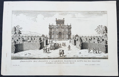
1685 G B Falda & Sandrart Antique Print Villa Gardens Doria Pamphili, Rome Italy
- Title : Prospecto Del Palazzo & Giardino Pamphilio Detto Del Bel Respiro...Architettura del Caualier Alessandro Algardi...Simon Felice delin....Norimburga appresso Gioni. Gac. de Sandart
- Ref #: 93463
- Size: 19in x 12 1/2in (490mm x 335mm)
- Date : 1685
- Condition: (A+) Fine Condition
Description:
This fine original copper plate engraved antique print of the Villa & Gardens of Doria Pamphili, Rome was engraved by Simone Felice for the 1685 edition of Giovanni Battista Faldas Li giardini di Roma, disegnati da Giovanni Battista Falda nuovamente dati alle stampe con direttione di Giov. Giacomo de Sandrart (The gardens of Rome, designed by Giovanni Battista Falda again printed with the direction of Giov. Giacomo de Sandrart) published in Nuremberg by Johann von Sandrart.
The work is based on the original series edited by Gian Giacomo de Rossi a few years earlier (the first edition was certainly published after 1677 but before 1683) which included 19 tables of plants and perspective views of the most famous Roman gardens, 14 of which were engraved by GB Falda and 5 by Simon Felice.
General Definitions:
Paper thickness and quality: - Heavy and stable
Paper color : - off white
Age of map color: -
Colors used: -
General color appearance: -
Paper size: - 19in x 12 1/2in (490mm x 335mm)
Plate size: - 16in x 9 1/2in (400mm x 250mm)
Margins: - Min 1in (25mm)
Imperfections:
Margins: - None
Plate area: - None
Verso: - None
Background:
The Villa Doria Pamphili is a seventeenth-century villa with what is today the largest landscaped public park in Rome, Italy. It is located in the quarter of Monteverde, on the Gianicolo (or the Roman Janiculum), just outside the Porta San Pancrazio in the ancient walls of Rome where the ancient road of the Via Aurelia commences.
It began as a villa for the Pamphili family and when the line died out in the eighteenth century, it passed to Prince Giovanni Andrea IV Doria, and has been known as the Villa Doria Pamphili since.
The nucleus of the villa property, the Villa Vecchia or old villa, already existed before 1630, when it was bought by Pamfilio Pamfili, who had married the heiress Olimpia Maidalchini, to enjoy as a suburban villa. Thereafter he set about buying up neighbouring vineyards to accumulate a much larger holding, which was often known as the Bel Respiro or beautiful breath as it stood on high ground, above the malarial areas of Rome, and offered spectacular views which were a desirable feature of Baroque villa settings.
In 1644 Cardinal Giambattista Pamphili became elected to the papacy and took the name of Innocent X. In accordance with this change in status, the Pamphili aspired to a grander and more expansively sited new villa. Early designs were made, possibly by Virgilio Spada rather than the traditional attribution to Borromini, but these were rejected. Instead the project was placed in the hands of the Bolognese sculptor Alessandro Algardi in 1644, assisted by Giovanni Francesco Grimaldi.
The initial design had a central casino (not the modern usage as a gambling establishment) with wings, but only the central block was built. There is uncertainty as to who the architect was; Algardi was not an architect, and it may be that he had help from Carlo Rainaldi and that the construction was supervised by Grimaldi. The layout has a central circular room around which the other rooms were arranged. Construction began in 1645 and was complete by 1647 although embellishments and the garden layouts were not finished until 1653. The casino, sometimes known as the Casino del Bel Respiro, was designed as a complement to the Pamphili collection of sculptures both ancient and modern, and other Roman antiquities such as vases, sarcophagi and inscriptions; it was only ever intended for display of the collection and the family and guests resided in the older Vecchia Vigna.
As a show case for sculpture, the somewhat crowded Casino facades have rhythmically alternating windows with niches which were elaborately adorned with sculptures, both antique and modern, with busts in hollowed roundels, with panels of bas-reliefs, and reliefs.
The exterior containing statues gives a rich allure that was architecturally somewhat conservative for its date, looking back towards the Villa Medici or the Casina Pio IV, and rather more Mannerist than Baroque. It offered a foretaste of the richly stuccoed and frescoed interiors, where the iconographic program set out to establish the antiquity of the Pamphili, a family then somewhat parvenu in Rome, with origins in Gubbio. Inside, Algardi provided further bas-reliefs and stucco framing for the heroic frescoes drawn from Roman history painted by Grimaldi.
The casino is set into the hill slope such that the main entrance on the north side is at a level above the giardino segreto or secret garden enclosure on its south side, a parterre garden with low clipped hedges. The gardens on the sloping site were laid out from around 1650 by Innocents nephew, Camillo Pamphili, formalizing the slope as a sequence from the parterres that flank the Casino, to a lower level below, framed by the boschi or formalized woodlands that rose above clipped hedges, and eventually arriving at a rusticated grotto in the form of an exedra, from which sculptured figures emerge from the rockwork. The exedra, now grassed, formerly enframed a Fountain of Venus by Algardi, which is preserved in the Villa Vecchia, together with Algardis bas-reliefs of putti representing Love and the Arts that were formerly here. The fountain spilled into a small cascade that let into a short length of formal canal, which was intended to remind the viewer of the similar Canopus at Hadrians Villa— another programmatic connection of the Pamphili with Antiquity.
When Girolamo Pamphili died in 1760 without male heirs, the disputes which broke out among the possible heirs were settled in 1763 when Pope Clement XIII Rezzonico granted to Prince Giovanni Andrea IV Doria the right to take the surname, the arms and the vast properties of the Pamphili; the Princes claim was based on the marriage between Giovanni Andrea III Doria and Anna Pamphili. Since then, the villa has been known as the Villa Doria Pamphili.
Throughout the 18th century, features were regularly added such as fountains and gateways by Gabriele Valvassori and other architects retained by the Pamphili and their heirs. After the Napoleonic era, more sweeping changes were made. The parterres that were formal extensions of the casino were retained but replanted with the patterned planting of colourful carpet bedding supplied from greenhouses by the old villa. (Today the parterres have been replanted in 16th-century style, with panels of scrolling designs in close-clipped greens set in wide gravel walks.) In the sloping outer gardens the changes were more extensive, recasting them in the naturalistic manner of English landscape gardens. The grounds, filled with many surprise features and picturesque incidents, swept down to a small lake at the bottom, which already had an air of atmospheric maturity when it was painted in the 1830s by Alexandre-Gabriel Decamps. In the wooded, natural-appearing landscapes with clumps of characteristic umbrella-like stone pines along horizons stand statues and vases, which evoke a nostalgic antiquity. The 18th-century English landscape gardens such as Stowe and Stourhead that were the inspiration for this style aimed to bring to life the Italian landscapes with Roman ruins painted by Claude and Poussin. A notable difference is that at the Villa Doria Pamphilis giardino inglese the Roman remains are likely to be genuine. The site of the villa contained several Roman tombs that yielded vases, sarcophagi and inscriptions that were added to the Pamphili collection.
Falda, Giovanni Battista 1643 – 1678
Falda was an Italian architect, engraver and artist. He is known for his engravings of both contemporary and antique structures of Rome.
Falda was sent as a boy to Rome, to work in the studio of Bernini, and his draughtsmanship caught the eye of the publisher Giovanni Giacomo de Rossi. He engraved for Le fontane di Roma (Fountains in Rome) and for Palazzi di Roma (Palaces of Rome). The former books was expanded after Faldas death with engravings by Francesco Venturini. The latter was published in 1655 in collaboration with Pietro Ferrerio. He is sometimes known as Falda da Valduggia because of his birthplace.
His works became particularly popular with the first waves of Grand Tour participants during the latter parts of the 17th century and Falda became a commercial success as a result. His works appealed to tourists keen to retain a detailed and accurate representation of those parts of Rome they had visited.
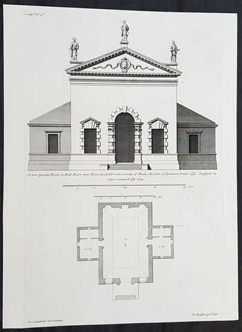
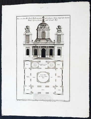
1724 Colen Campbell Antique Architect Print Garden Room Hall Barn, Downton Abbey
- Title : A new Garden Room at Hall Barn near Beaconsfield in the County of Bucks... Vol. 3, pl. 49.
- Ref #: 93462
- Size: 15in x 11 1/2in (380mm x 295mm)
- Date : 1724
- Condition: (A+) Fine Condition
Description:
This fine original copper-plate engraved of the Garden Room of Hall Barn in Beaconsfield, Buckinghamshire, England, designed by the famous Scottish architect and publisher Colen Campbell was engraved in 1724 - dated - by the Dutch engraver Henry Hulsbergh - and was published in the 1724 edition of Campbells monumental architectural publication Vitruvius Britannicus or The British Architect. London
Hall Barn was also the location used in the filming of the TV series Downton Abbey as the Loxley House.
General Definitions:
Paper thickness and quality: - Heavy and stable
Paper color : - off white
Age of map color: - Original
Colors used: - Yellow, green, blue, pink
General color appearance: - Authentic
Paper size: - 15in x 11 1/2in (380mm x 295mm)
Plate size: - 15in x 9 1/2in (380mm x 235mm)
Margins: - Min 1/2in (12mm)
Imperfections:
Margins: - None
Plate area: - None
Verso: - None
Background:
Hall Barn is a historic country house located in Beaconsfield, South Bucks district, in Buckinghamshire, England.
The Hall Barn estate was bought by Anne Waller in 1624. The house was built in the late-17th century by her son Edmund Waller, a poet and Member of Parliament at various times between 1624 and 1679. His grandson added the south wing. The estate was sold by his family in 1832 to Sir Gore Ouseley, 1st Baronet, who rebuilt the southern facade and was High Sheriff of Buckinghamshire for 1835.
Edward Levy-Lawson, 1st Baron Burnham bought the estate in 1880 and made a number of renovations and improvement and the estate remains under the management of the Lawson family - Hugh Lawson, 6th Baron Burnham - in the early 21st century.
There were royal visits to the estate, including from the Duke of Cambridge in November 1902. The Princess Royal took the salute at Hall Barn in the 1940s at the Girl Guide County Rally.
During the Second World War, the house was used as a hospital supplies unit. In November 1946, the Hall Barn Estate was reported in Tatler as being the lovely home and venue for the wedding reception for extended family and friends of the newly-wed daughter of the charming Lord and Lady Burnham.
Hall Barn has been used as a filming location for various films and series. In Gosford Park (2001) the opening sequence outside Lady Trenthams home was shot there, and the temple used as the scene for lunch after the shoot. Midsomer Murders Season 7, Episode 4 (2004) Sins of Commission, prominently features the black gatehouse to Hall Barn. It featured in the series Downton Abbey as Loxley House, the home of Sir Anthony Strallan. The location was also used in the 1981 Oscar-winning film Chariots of Fire as the home of the composite character Lord Andrew Lindsay, who memorably practiced his hurdling skills on the lawn by perching filled champagne glasses on each hurdle to determine if hed touched the hurdles or not on each jump. Hall Barn was also featured in the mini-series Sense and Sensibility (2008 miniseries), and used as the location for Delaford House. Black Beauty Film (1994)
Vitruvius Britannicus or The British Architect is from one of the finest works on architecture ever produced. Colen Campbell published the work in London in 1725. The engravings from this work feature illustrations, plans, and cross sections of English country houses and parks.
Campbell was the chief architect to the Prince of Wales. His work served as a design book that led to the construction of many of Britain’s great houses. Vitruvius Britannicus established Palladian architecture as the dominant style England in the 18th century.
Vitruvius Britannicus documented the buildings of some of the greatest architects of the times including Indigo Jones, Sir Christopher Wren, and Colen Campbell himself. The work is essential to the study of 17th and 18th century design and architecture in England.
Campbell, Colen 1676 - 1729
Campbell was a pioneering Scottish architect and architectural writer, credited as a founder of the Georgian style. For most of his career, he resided in Italy and England.
A descendant of the Campbells of Cawdor Castle, he is believed to be the Colinus Campbell who graduated from the University of Edinburgh in July 1695. He initially trained as a lawyer, being admitted to the Faculty of Advocates on 29 July 1702.
He had travelled in Italy from 1695–1702 and is believed to be the Colinus Campbell who signed the visitors book at the University of Padua in 1697. He is believed to have trained in and studied architecture under James Smith, this belief is strengthened by Campbell owning several drawings of buildings designed by Smith.
His major published work, Vitruvius Britannicus, or the British Architect... appeared in three volumes between 1715 and 1725. (Further volumes using the successful title were assembled by Woolfe and Gandon, and published in 1767 and 1771, see below.) Vitruvius Britannicus was the first architectural work to originate in England since John Shutes Elizabethan First Groundes. In the empirical vein, it was not a treatise but basically a catalogue of design, containing engravings of English buildings by Inigo Jones and Sir Christopher Wren, as well as Campbell himself and other prominent architects of the era.
In the introduction that he appended and in the brief descriptions, Campbell belaboured the excesses of Baroque style and declared British independence from foreigners while he dedicated the volume to Hanoverian George I. The third volume (1725) has several grand layouts of gardens and parks, with straight allées, for courts and patterned parterres and radiating rides through wooded plantations, in a Baroque manner that was rapidly becoming old-fashioned.
Buildings were shown in plan, section and elevation, but also some were in a birds-eye perspective. The drawings and designs contained in the book were under way before Campbell was drawn into the speculative scheme. The success of the volumes was instrumental in popularising neo-Palladian Architecture in Great Britain and America during the 18th century. For example, Plate 16 of Vitruvius Britannicus, a rendering of Somerset House in London, was an inspiration for American architect Peter Harrison when he designed the Brick Market in Newport, Rhode Island, in 1761.
Campbell was influenced as a young man by James Smith (ca 1645 – 1731), the pre-eminent Scots architect of his day, and an early neo-Palladian whom Campbell called the most experienced architect of Scotland (Vitruvius Britannicus, ii).
The somewhat promotional volume, with its excellently rendered engravings, came at a propitious moment at the beginning of a boom in country house and villa building among the Whig oligarchy. Campbell was quickly taken up by Lord Burlington, who replaced James Gibbs with Campbell at Burlington House in London and set out to place himself at the center of English neo-Palladian architecture. In 1718, Campbell was appointed deputy to the amateur gentleman who had replaced Wren as Surveyor General of the Royal Board of Works, an appointment that Burlington is certain to have pressed, but a short-lived one. When Benson, the new Surveyor was turned out of office, Campbell went with him.
Later Volumes There are some later volumes also published under the name Vitruvius Brittanicus, but they are not connected to Colen Campbells work, issued between 1715-1725. In 1739 a volume was issued by Badeslade and Rocque, described as Volume 4. However, this had little in common with Campbell, comprising mainly topographical perspective views of houses (54 plates). Between 1765–1771, Woolfe and Gandon published their Volumes 4 & 5 (with 79 plus 75 plates). They discounted Badeslades volume, believing their work to be a more correct continuation of Campbell, hence numbering it as Volume 4. The plates are indeed mostly plans and elevations of buildings largely in the Palladian style, most dating from after 1750. The various Volumes are fully described in Harris.
- Wanstead House, Essex: ca 1713/4 – 20 (illustrated left) In the first volume of Vitruvius Britannicus the most influential designs were two alternatives for a palatial Wanstead House, Essex, for the merchant-banker Sir Richard Child, of which the second design was already under way when the volume was published. (Campbell claimed that Wanstead House had Great Britains first classical portico, but this accolade probably belongs to The Vyne, Hampshire.
- Burlington House, London 1717. Remodelled the front and provided an entrance gateway for Richard Boyle, 3rd Earl of Burlington (Remodelled in 1868 and the gateway demolished.
- Stourhead, Wiltshire, 1721–24, as a seat for the London-based banker Henry Hoare. Wings were added in the later 18th century, and Campbells portico was not executed (though to his design) until 1841. The famous landscape garden round a lake, somewhat apart from the house, was developed after Campbells death, by Henry Flitcroft.
- Pembroke House, Whitehall, London, for Henry Herbert, 9th Earl of Pembroke, 1723, a London house in a prominent location for the heir of Jones Wilton House. It was rebuilt in 1757 and demolished in 1913. Lord Herbert (as he then was) was inspired by it to design the similar Marble Hill at Twickenham for Henrietta Howard, Countess of Suffolk, the mistress of the future George II. (Marble Hill was a 5-bay palladian villa with central pediment, raised on a high basement, with clumped screens of trees and formal turfed terraces descending to the Thames, illustrated right, that manifest the earliest stages of the English landscape garden.
- Houghton Hall, Norfolk, begun 1722, for Sir Robert Walpole, the Whig prime minister. Here Campbell was replaced by Gibbs, who capped the end pavilions with octagonal domes, and by William Kent, who designed the interiors.
- Mereworth Castle, Kent 1722 – 25: Campbells most overtly palladian design, based on Villa La Rotonda, capped with a dome with no drum, through which 24 chimney flues pass to the lantern.
- Waverley Abbey House, Surrey ca 1723–25 for John Aislabie (largely altered)
Title page, Vitruvius Britannicus; or, The British architect, containing the plans, elevations, and sections of the regular buildings, both publick and private in Great Britain, with variety of new designs, written by Colen Campbell
Nos 76 and 78 Brook Street, London W1, 1725 – 26. No. 76, which survives, was Campbells own house, the designs for its interiors published in his Five Orders of architecture, (1729). It carries a blue plaque commemorating him.
Compton Place, Eastbourne, Sussex, 1726 onwards, south front and extensive internal rebuilding for Sir Spencer Compton
Plumptre House, Nottingham 1724 - 30. Remodelled for John Plumptre MP.
Shawfield Mansion, Glasgow (1712) demolished 1792
Wanstead House, Essex (1714–15) demolished 1822
Hedworth House, Chester-le-Street (1726)
Hotham House, Beverley (1716–17) demolished c.1766
Burlington House, London, south front, and west wing (1717) subsequently extended and several occasions
Burlington (Ten Acre Close) Estate, London, layout (1717–18)
Burlington House, Great Gate and Street Wall (1718)
Rolls House, Chancery Lane, London (1718), demolished 1895–96
Ebberston Lodge, Ebberston, Yorkshire, including cascade (1718)
34 Great Burlington Street, London (1718–19)
33 Great Burlington Street, London (1719–20)
32 Great Burlington Street, London (c.1720); this was Campbells own house
31 Great Burlington Street, London (1719–24) rebuilt
Burlington Girls Charity School, Boyle Street, London (1719–21)
Wimbledon Manor House, Surrey, for Sir Theodore Janssen (1720); completion uncertain
Newby Park, (now Baldersby Park), near Topcliffe, Yorkshire (1720–21)
Houghton Hall, Norfolk; one of several architects to work on the building (1721–22)
Stourhead, Wiltshire, the portico part of Campbells design was only added in 1840 (1721–24); interiors destroyed by fire 1902
Mereworth Castle, Kent (1722–23)
Pembroke Lodge, Whitehall, London; executed Henry Herbert, 9th Earl of Pembrokes design (c.1724), demolished 1756
Plumptre House, Nottingham (1724)
Hall Barn, Buckinghamshire, garden buildings: Great Room (only partially survives), Temple of Venus, Obelisk & Doric Pavilion (1724)
Waverley Manor, Surrey (c.1725), extended 1770, damaged by fire and rebuilt 1833
Greenwich Hospital, Greenwich, London; additions to Queen Mary block and Queen Anne block (1726–29)
Compton Place, Eastbourne, remodelled house (1726–29)
76 Brook Street, London, internal alterations (c.1726); became Campbells new home
Hackney House, Hackney, London (c.1727), demolished before 1842
Althorp, Northamptonshire, new stables, loggia gate (c.1729–33)
Studley Royal Park, Yorkshire, the stables (c.1729) built after his death by Roger Morris
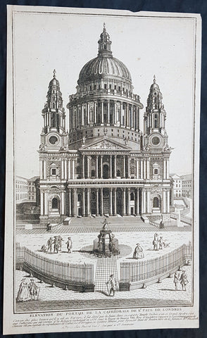
1770 Louis-Joseph Mondhare Antique Print View of St Pauls Cathedral, London England
- Title : Elevation Du Portail De La Cathedrale De St Paul De Londre
- Ref #: 93461
- Size: 14 1/2in x 9in (365mm x 245mm)
- Date : 1770
- Condition: (A+) Fine Condition
Description:
This original copper plate engraved antique print of St Pauls Cathedral, London was engraved and published by Louis-Joseph Mondhare in Paris in 1770
General Definitions:
Paper thickness and quality: - Heavy and stable
Paper color : - off white
Age of map color: -
Colors used: -
General color appearance: -
Paper size: - 14 1/2in x 9in (365mm x 245mm)
Plate size: - 14 1/2in x 9in (365mm x 245mm)
Margins: - Min 1/8in (5mm)
Imperfections:
Margins: - Margins cropped to plate mark
Plate area: - None
Verso: - None
Imperfections:
Margins: - None
Plate area: - None
Verso: - None
Background:
The task of designing a replacement structure was officially assigned to Sir Christopher Wren on 30 July 1669. He had previously been put in charge of the rebuilding of churches to replace those lost in the Great Fire. More than 50 City churches are attributable to Wren. Concurrent with designing St Pauls, Wren was engaged in the production of his five Tracts on Architecture.
Wren had begun advising on the repair of the Old St Pauls in 1661, five years before the fire in 1666. The proposed work included renovations to interior and exterior to complement the classical facade designed by Inigo Jones in 1630. Wren planned to replace the dilapidated tower with a dome, using the existing structure as a scaffold. He produced a drawing of the proposed dome which shows his idea that it should span nave and aisles at the crossing. After the Fire, it was at first thought possible to retain a substantial part of the old cathedral, but ultimately the entire structure was demolished in the early 1670s.
In July 1668 Dean William Sancroft wrote to Wren that he was charged by the Archbishop of Canterbury, in agreement with the Bishops of London and Oxford, to design a new cathedral that was Handsome and noble to all the ends of it and to the reputation of the City and the nation. The design process took several years, but a design was finally settled and attached to a royal warrant, with the proviso that Wren was permitted to make any further changes that he deemed necessary. The result was the present St Pauls Cathedral, still the second largest church in Britain, with a dome proclaimed as the finest in the world. The building was financed by a tax on coal, and was completed within its architects lifetime with many of the major contractors engaged for the duration.
The topping out of the cathedral (when the final stone was placed on the lantern) took place on 26 October 1708, performed by Wrens son Christopher Jr and the son of one of the masons. The cathedral was declared officially complete by Parliament on 25 December 1711 (Christmas Day). In fact, construction continued for several years after that, with the statues on the roof added in the 1720s. In 1716 the total costs amounted to £1,095,556 (£165 million in 2019).
On 2 December 1697, 31 years and 3 months after the Great Fire destroyed Old St Pauls, the new cathedral was consecrated for use. The Right Reverend Henry Compton, Bishop of London, preached the sermon. It was based on the text of Psalm 122, I was glad when they said unto me: Let us go into the house of the Lord. The first regular service was held on the following Sunday.
Opinions of Wrens cathedral differed, with some loving it: Without, within, below, above, the eye / Is filled with unrestrained delight, while others hated it: There was an air of Popery about the gilded capitals, the heavy arches ... They were unfamiliar, un-English
Mondhare & Jean (active 1759 - 1829)
Louis-Joseph Mondhare (1734 - Paris 1799) & Pierre Jean (1754 - 1829) were prominent Parisian publishers, engravers, print and map sellers who were active in Paris in the late 18th and early 19th centuries.
In 1784 Jean married the daughter of Mondhare, who formed a partnership with his son in law, changing forming a very successful partnership thereafter as Mondhare & Jean.
After Mondhare retirement in 1796, Jean carried on with the publishing & printing business, having inherited all of the printing plates that also included many map plates from the likes of Nolin, Clouet, D Anville , Delsile and others. Both Mondhare and Jean were responsible for the engraving and printing of the very decorative large wall maps by J B Nolin & J B L Clouet, as well as single plate maps and atlases. Mondares premises were located at Rue St Jacques, à lHôtel Saumur later movin
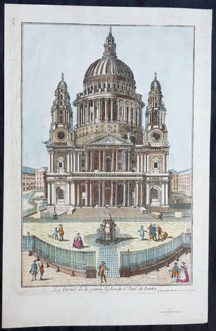
1770 Louis-Joseph Mondhare Antique Print View of St Pauls Cathedral, London UK
- Title : Le Portail de la grande Eglise de St Paul de Londre...a Paris chez Mondhare ru st Jacques
- Ref #: 93460
- Size: 15in x 9 1/2in (380mm x 235mm)
- Date : 1770
- Condition: (A+) Fine Condition
Description:
This original hand coloured copper plate engraved antique print of St Pauls Cathedral, London was engraved and published by Louis-Joseph Mondhare in Paris in 1770
General Definitions:
Paper thickness and quality: - Heavy and stable
Paper color : - off white
Age of map color: - Early
Colors used: - Blue, pink, red, green, yellow
General color appearance: - Authentic
Paper size: - 15in x 9 1/2in (380mm x 235mm)
Plate size: - 13in x 9in (330mm x 230mm)
Margins: - Min 1/2in (12mm)
Imperfections:
Margins: - None
Plate area: - None
Verso: - None
Background:
The task of designing a replacement structure was officially assigned to Sir Christopher Wren on 30 July 1669. He had previously been put in charge of the rebuilding of churches to replace those lost in the Great Fire. More than 50 City churches are attributable to Wren. Concurrent with designing St Pauls, Wren was engaged in the production of his five Tracts on Architecture.
Wren had begun advising on the repair of the Old St Pauls in 1661, five years before the fire in 1666. The proposed work included renovations to interior and exterior to complement the classical facade designed by Inigo Jones in 1630. Wren planned to replace the dilapidated tower with a dome, using the existing structure as a scaffold. He produced a drawing of the proposed dome which shows his idea that it should span nave and aisles at the crossing. After the Fire, it was at first thought possible to retain a substantial part of the old cathedral, but ultimately the entire structure was demolished in the early 1670s.
In July 1668 Dean William Sancroft wrote to Wren that he was charged by the Archbishop of Canterbury, in agreement with the Bishops of London and Oxford, to design a new cathedral that was Handsome and noble to all the ends of it and to the reputation of the City and the nation. The design process took several years, but a design was finally settled and attached to a royal warrant, with the proviso that Wren was permitted to make any further changes that he deemed necessary. The result was the present St Pauls Cathedral, still the second largest church in Britain, with a dome proclaimed as the finest in the world. The building was financed by a tax on coal, and was completed within its architects lifetime with many of the major contractors engaged for the duration.
The topping out of the cathedral (when the final stone was placed on the lantern) took place on 26 October 1708, performed by Wrens son Christopher Jr and the son of one of the masons. The cathedral was declared officially complete by Parliament on 25 December 1711 (Christmas Day). In fact, construction continued for several years after that, with the statues on the roof added in the 1720s. In 1716 the total costs amounted to £1,095,556 (£165 million in 2019).
On 2 December 1697, 31 years and 3 months after the Great Fire destroyed Old St Pauls, the new cathedral was consecrated for use. The Right Reverend Henry Compton, Bishop of London, preached the sermon. It was based on the text of Psalm 122, I was glad when they said unto me: Let us go into the house of the Lord. The first regular service was held on the following Sunday.
Opinions of Wrens cathedral differed, with some loving it: Without, within, below, above, the eye / Is filled with unrestrained delight, while others hated it: There was an air of Popery about the gilded capitals, the heavy arches ... They were unfamiliar, un-English
Mondhare & Jean (active 1759 - 1829)
Louis-Joseph Mondhare (1734 - Paris 1799) & Pierre Jean (1754 - 1829) were prominent Parisian publishers, engravers, print and map sellers who were active in Paris in the late 18th and early 19th centuries.
In 1784 Jean married the daughter of Mondhare, who formed a partnership with his son in law, changing forming a very successful partnership thereafter as Mondhare & Jean.
After Mondhare retirement in 1796, Jean carried on with the publishing & printing business, having inherited all of the printing plates that also included many map plates from the likes of Nolin, Clouet, D Anville , Delsile and others. Both Mondhare and Jean were responsible for the engraving and printing of the very decorative large wall maps by J B Nolin & J B L Clouet, as well as single plate maps and atlases. Mondares premises were located at Rue St Jacques, à lHôtel Saumur later movin
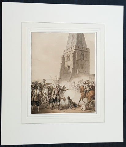
1810 John Augustus Atkinson Original Water Colour Art of an English War Skirmish
- Title : (A Civil War Skirmish)
- Ref #: 93444
- Size: 17in x 15in (430mm x 365mm)
- Date : 1810
- Condition: (A+) Fine Condition
Description:
This beautifully executed original pen, pencil and watercolour picture of an English Civil War battle scene was painted by John Augustus Atkinson in ca 1810.
Atkinson was known for his battle scene art works during his time at the St Petersburg Court in Russia as well as his Napoleonic battle scenes from the early 19th century.
Atkinson is held in high esteem as a watercolourist, and was elected as a member of the Society of Painters in Water Colours in 1808. He has works of art held at many prestigious museums in Russia, Europe and the UK, such as the Tate, Royal Watercolour Society, National Maritime Museum and many more listed below. He also sells on the open market with this piece last sold in 2004.
Professionally matted and can be easily removed if required.
General Definitions:
Paper thickness and quality: - Heavy and stable
Paper color : - off white
Age of map color: - Original
Colors used: - Blue, pink, red, green, yellow
General color appearance: - Authentic
Paper size: - 17in x 15in (430mm x 365mm)
Plate size: - 9 3/4in x 8in (247mm x 203mm)
Margins: - Min 0in (0mm)
Imperfections:
Margins: - None
Plate area: - None
Verso: - None
Background:
The English Civil War (1642–1651) was a series of civil wars and political machinations between Parliamentarians (Roundheads) and Royalists (Cavaliers) principally over the manner of Englands governance and part of the wider Wars of the Three Kingdoms. The first (1642–1646) and second (1648–1649) wars pitted the supporters of King Charles I against the supporters of the Long Parliament, while the third (1649–1651) saw fighting between supporters of King Charles II and supporters of the Rump Parliament. The war ended with Parliamentarian victory at the Battle of Worcester on 3 September 1651.
Unlike other civil wars in England, which were mainly fought over who should rule, these conflicts were also concerned with how the three kingdoms of England, Scotland, and Ireland were to be governed. The outcome was threefold: the trial and execution of Charles I (1649); the exile of his son, Charles II (1651); and the replacement of English monarchy with, at first, the Commonwealth of England (1649–1653) and then the Protectorate, which as the Commonwealth of England, Scotland, and Ireland unified the British Isles under the personal rule of Oliver Cromwell (1653–1658) and briefly his son Richard (1658–1659). The execution of Charles I was particularly notable given that an English king had never been executed before. In England, the monopoly of the Church of England on Christian worship was ended, while in Ireland the victors consolidated the established Protestant Ascendancy. Constitutionally, the wars established the precedent that an English monarch cannot govern without Parliaments consent, although the idea of Parliamentary sovereignty was only legally established as part of the Glorious Revolution in 1688.
Atkinson, John Augustus 1775 - 1830
Atkinson was an English artist, engraver and watercolourist.
He was born in London and at the age of 9, in 1784, went to live with his uncle, the famous engraver James Walker, in St Petersburg, Russia. Walker was engraver to the empress Catherine the Great 1729 - 1796 and encouraged Atkinson to study art, seeing a talent in him. Atkinson was well placed in St Petersburg to study art, being surrounded by the many collections of Catherine and the Russian Nobility, the richest in Europe. It is known that Atkinson was encouraged by Catherine herself along with and her son & later Emperor of Russia Paul I 1754 - 1801. Paul later commissioned Atkinson to paint large pieces from Russian history that can be seen in many Museums today around the world.
After the death of Paul in 1801, Atkinson returned to England and in 1803 published A Picturesque Representation of the Manners, Customs, and Amusements of the Russians, in 100 plates, drawn and etched by himself. He also painted in watercolours and in 1808 was elected to the Society of Painters in Water Colours. Many of his works, during the Napoleonic wars, were of naval subjects. He painted many battle scenes including a Battle of Waterloo, which was engraved by John Burnet.
His last contribution to the Royal Academy exhibition was in 1829. He died on 25 March 1830 in London.
Selected Works
• Carriage on Sledges 1803 Art Gallery of Greater Victoria, British Columbia
• A Russian Village 1804 Art Gallery of Greater Victoria, British Columbia
• Golubtza 1804 Art Gallery of Greater Victoria, British Columbia
• Village Amusements 1804 Art Gallery of Greater Victoria, British Columbia
• Scene from Tom Jones Courtauld Institute of Art, London
• The Slack Rope Courtauld Institute of Art, London
• A Belgian Waggon with Four Horses Tate Gallery, London
• Illustrations to Ossian The Huntington Library, California
• Heaving a Lead 1807 National Maritime Museum
• Greenwich Pensioners 1808 National Maritime Museum
• Skating, 1810 Tyne & Wear Museums, England
• Ships of the Reign of King Edward IV 1812 - Fine Arts Museums of San Francisco
• 42nd Highlanders at Waterloo Courtauld Institute of Art, London
• British Sailors Boarding a Man of War 1815 National Maritime Museum
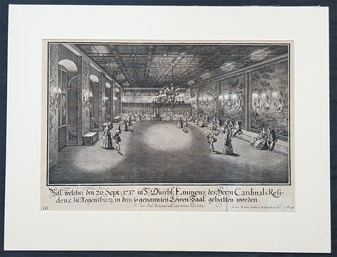
1735 Schubler & Steidlin Antique Baroque Print Musical Ball Regensburg Ger. 1717
- Title : Bal, welche den 26. Sept: 1717 in Sr Durchl: Eminens des Herrn Cardinals residens zu Regensburg, in dem so genamten Lowen-Saal, gehalten worden....NB das Bal Zimmer war mit rohten Tuch belegt
- Ref #: 93443
- Size: 19in x 13 1/2in (490mm x 345mm)
- Date : 1735
- Condition: (A) Very Good Condition
Description:
This large original Baroque copper plate engraved antique print, numbered three of three, of an early 18th century Ball, part of the celebrations at the Royal Court in the Cardinal Castle of Regensburg, on September 26, 1717, by Johann Schubler, was engraved by Johann Matthias Steidlin or Steudlin 1717-1754 and published by the Jeremias Wolff Erben in 1735.
A wonderful piece of Baroque art, engraved and published by some of the foremost art engravers and publishers at the beginning of the 18th century.
Professionally matted and can be easily removed if required.
General Definitions:
Paper thickness and quality: - Heavy and stable
Paper color : - off white
Age of map color: -
Colors used: -
General color appearance: -
Paper size: - 19in x 13 1/2in (490mm x 345mm)
Plate size: - 19in x 13 1/2in (490mm x 345mm)
Margins: - Min 1/2in (12mm)
Imperfections:
Margins: - Small repair bottom right signature
Plate area: - Folds as issued
Verso: - None
Background:
In 1245 Regensburg became a Free Imperial City and was a trade centre before the shifting of trade routes in the late Middle Ages. In 1486, Regensburg became part of the Duchy of Bavaria, but its independence was restored by the Holy Roman Emperor ten years later. In the city took place the Diet of 1541, was adopted the Protestant Reformation in 1542 and its Town Council remained entirely Lutheran. From 1663 to 1806, the city was the permanent seat of the Imperial Diet of the Holy Roman Empire, which became known as the Perpetual Diet of Regensburg. Thus, Regensburg was one of the central towns of the Empire, attracting visitors in large numbers.
A minority of the population remained Roman Catholic, and Roman Catholics were denied civic rights (Bürgerrecht). Although the Imperial city had adopted the Reformation, the town remained the seat of a Roman Catholic bishop and several abbeys. Three of these, St. Emmeram, Niedermünster and Obermünster, were free imperial estates within the Holy Roman Empire, meaning that they were granted a seat and a vote at the Imperial Diet (Reichstag). So there was the unique situation that the town of Regensburg comprised five independent states (in terms of the Holy Roman Empire): the Protestant city itself, the Roman Catholic bishopric, and the three monasteries. In addition, it was seen as the traditional capital of the region Bavaria (not the state), acted as functional co-capital of the Empire (second to the Emperors court at Vienna) due to the presence of the Perpetual Diet, and it was the residence of the Emperors Commissary-Principal to the same diet, who with one very brief exception was a prince himself (for many years the Prince of Thurn and Taxis, still resident in the town).
Schübler, Johann Jacob 1689 - 1741
Schübler was born in Nuremberg as was known as a versatile German baroque master builder , architectural theorist and writer and mathematician.
Schüblers father Johann Jacob was a braid maker and language teacher, and he also had medical knowledge, which he also used for a fee. He came to Nuremberg from Strasbourg and became resident there by marrying Maria Elisabeth Hengel, the daughter of an independent braid maker. The later master builder Johann Jacob Schübler was the fourth of the couples eight children. Through his father and private tutors, he received careful training, mainly in artistic subjects as well as in old and new languages. Architectural painter Johann Andreas Graff gave him his first drawing lessons . In 1698 he began his apprenticeship as a draftsman in the studio of the portraitist, engraver and art dealerJacob von Sandrart (1630-1708), in addition he was taught by Georg Christoph Eimmart (1638-1705), the long-time director of the important Nuremberg Academy of Painters , a representative of the mathematically oriented artists of the time and founder of the observatory at the Nuremberg castle .
At that time, extensive study trips were common for aspiring artists to complete their training. Between 1705 and 1713, Schüblers years of traveling took him through Germany, Denmark and Norway, the Netherlands and France - with a stopover in 1711 with his parents in Nuremberg. The time around 1700 in Europe was particularly intensive secular and church building activity, numerous elaborate, representative buildings. Schüblers travel destinations were primarily places where the current building activity was concentrated. However, Italy was missing from this program. He made longer stays for scholarly studies in Leipzig and Copenhagen .
After his return in 1713, Schübler remained settled in Nuremberg. Prominent colleagues such as Balthasar Neumann (1687–1753) visited him and he corresponded with well-known artists and scientists. He rejected various offers from foreign employers because they did not seem attractive enough to him. In 1717 he received the order for a gate of honor, which was built to celebrate a princely wedding in the main square of the residential city of Sulzbach . Schübler had an expansive triumphal arch with three stacked columns and niches for allegorical figures built, which was generally praised. A permanent position at the court of the Sulzbach Palatinate Countshowever, did not result from this. So he remained the prevented Builder. Great vocations only reached him towards the end of his life. In 1740 the Danish king invited him to Copenhagen, in 1741 negotiations for a move to Berlin followed to the court of the Prussian king Friedrich II. Both offers came too late for Schübler. He died in September 1741 from a clock-like illness.
Schübler only started his own family at an advanced age. In 1727 he married Margareta Maria Hemme, the daughter of a respected art dealer. At around 40, the bride was even a little older than Schübler herself; she died two years after the marriage, the marriage remained childless. In 1733 Schübler had a second marriage to 26-year-old Margaretha Setzmair. She also came from a long-established, wealthy middle-class family. The couple had two daughters, one of whom died very early, and a son who was born several months after Schüblers death.
In 1734 Schübler was accepted as an external member of the Prussian Academy of Sciences in Berlin. The small Schüblerstrasse in Nuremberg reminds him of him.
Schüblers actual lifes work consisted of a large number of writings, the publication of which he began around 1715. With his later works in particular, he pursued the intention of scientifically examining the questions of the building industry based on proportion and perspective, thereby making them teachable and learnable for building theorists and practitioners of his time.
Initially, Schübler published smaller masterpieces that appeared in deliveries of six to twelve engravings and contained hardly any text. In it he showed architectural details (e.g. fireplaces , mansard windows , pulpits, altars, confessionals), furniture (beds, desks, clocks, night chairs) and technical objects such as pumping stations and fountains. He drew the originals himself, often with a light color, but hardly ever took over the transfer to the printing plates, even though he knew this technique. For this, he employed a large number of engravers, among them Johann August Corvinus, Johann Matthias Steidlin, Georg Lichtensteger and his own brother Georg Andreas. The objects depicted often appear grotesquely overloaded with decorative elements such as flower threads, sphinxes and the like, but were also not intended for direct implementation. Rather, the executing tradesmen were able to take very different suggestions from a single template. The templates appeared in the publisher Jeremias Wolff in Augsburg, which is renowned throughout Europe .
Schüblers more scientific and literary works were mostly published by Johann Christoph Weigel in Nuremberg. In 1719/20 Perspectiva Pes Picturae was published in two parts , a large-format work of art intended to provide the basis for architectural painting . 1723/24, again in two parts, came out a textbook on the column orders with practical aids for difficult problems, which was reprinted several times. This was followed by publications on the art of sundial (1726) and on the wood-fired parlor ovens(1728). Schüblers main works then appeared within five years. With them he wanted to provide a new, in-depth representation of the entire architecture, with the main areas of the Architectura Civilis and the Architectura Militaris . From the years 1732-35 are the five illustrated volumes of a Synopsis Architecturae Civilis eclecticae , to which the content of the theoretical work Ars inveniendi from 1734 on civil architecture can be assigned. The two volumes of carpentry (Ars Tignaria) date from 1731 and 1736 . The main works include Perspectiva Geometrica Practica .
Schüblers works were widespread, and individual writings had up to 20 editions. The last known new edition dates from 1786. The popularity of his practically applicable proposals ended with the domination of baroque and rococo in architecture. The new general artist lexicon by art historian Georg Kaspar Nagler (1801–1866) already discusses Schüblers works as examples of the aesthetic aberrations of an era that has been overcome and describes them as senseless outbursts of an unregulated imagination.
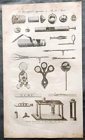
1798 W H Hall Large Antique Print of the Apparatus of The Microscope, Lenses
- Title : Microscophical Apparatus....Halls Encyclopedia...C. Cooke...
- Condition: (A) Very Good Condition
- Ref: 90677
- Size: 15in x 9in (380mm x 230mm)
- Date: 1798
Description:
This large original copper-plate engraved antique print was was published by William Henry Hall in the 1798 edition of The new royal encyclopedia; or, complete modern universal dictionary of arts and sciences on a new and improved plan.... printed by Charles Cooke, London.
General Definitions:
Paper thickness and quality: - Heavy and stable
Paper color : - off white
Age of map color: -
Colors used: -
General color appearance: -
Paper size: - 15in x 9in (380mm x 230mm)
Plate size: - 15in x 9in (380mm x 230mm)
Margins: - Min 1/2in (10mm)
Imperfections:
Margins: - Age toning
Plate area: - Light age toning
Verso: - Age toning
Background:
Although objects resembling lenses date back 4000 years and there are Greek accounts of the optical properties of water-filled spheres (5th century BC) followed by many centuries of writings on optics, the earliest known use of simple microscopes (magnifying glasses) dates back to the widespread use of lenses in eyeglasses in the 13th century. The earliest known examples of compound microscopes, which combine an objective lens near the specimen with an eyepiece to view a real image, appeared in Europe around 1620. The inventor is unknown although many claims have been made over the years. Several revolve around the spectacle-making centers in the Netherlands including claims it was invented in 1590 by Zacharias Janssen (claim made by his son) and/or Zacharias father, Hans Martens, claims it was invented by their neighbor and rival spectacle maker, Hans Lippershey (who applied for the first telescope patent in 1608) and claims it was invented by expatriate Cornelis Drebbel who was noted to have a version in London in 1619. Galileo Galilei (also sometimes cited as compound microscope inventor) seems to have found after 1610 that he could close focus his telescope to view small objects and, after seeing a compound microscope built by Drebbel exhibited in Rome in 1624, built his own improved version. Giovanni Faber coined the name microscope for the compound microscope Galileo submitted to the Accademia dei Lincei in 1625 (Galileo had called it the occhiolino or little eye).
The first detailed account of the microscopic anatomy of organic tissue based on the use of a microscope did not appear until 1644, in Giambattista Odiernas Locchio della mosca, or The Flys Eye.
The microscope was still largely a novelty until the 1660s and 1670s when naturalists in Italy, the Netherlands and England began using them to study biology. Italian scientist Marcello Malpighi, called the father of histology by some historians of biology, began his analysis of biological structures with the lungs. Robert Hookes Micrographia had a huge impact, largely because of its impressive illustrations. A significant contribution came from Antonie van Leeuwenhoek who achieved up to 300 times magnification using a simple single lens microscope. He sandwiched a very small glass ball lens between the holes in two metal plates riveted together, and with an adjustable-by-screws needle attached to mount the specimen. Then, Van Leeuwenhoek re-discovered red blood cells (after Jan Swammerdam) and spermatozoa, and helped popularise the use of microscopes to view biological ultrastructure. On 9 October 1676, van Leeuwenhoek reported the discovery of micro-organisms.
The performance of a light microscope depends on the quality and correct use of the condensor lens system to focus light on the specimen and the objective lens to capture the light from the specimen and form an image. Early instruments were limited until this principle was fully appreciated and developed from the late 19th to very early 20th century, and until electric lamps were available as light sources. In 1893 August Köhler developed a key principle of sample illumination, Köhler illumination, which is central to achieving the theoretical limits of resolution for the light microscope. This method of sample illumination produces even lighting and overcomes the limited contrast and resolution imposed by early techniques of sample illumination. Further developments in sample illumination came from the discovery of phase contrast by Frits Zernike in 1953, and differential interference contrast illumination by Georges Nomarski in 1955; both of which allow imaging of unstained, transparent samples.
Hall, William Henry
Hall was responsible for a significant publication in the middle of the 18th century The new royal encyclopedia; or, complete modern universal dictionary of arts and sciences on a new and improved plan . containing a digest and display of the whole theory and practice of the liberal and mechanical arts comprising a general repository of ancient and modern literature . including all the material information that is contained in Chamber s Cyclopedia, the Encyclopædia Britannica, and the French Encyclopædie . first published in 1788 going into many re-issues over the next 50 years.
The three volume set contained 153 copper-plate prints and maps, including some folding maps. Contained many brief encyclopedic entries in alphabetical orders plus longer, mainly illustrated, sections (systems or treatises) on a variety of subjects: Aerology; Aerostation (hot air balloons); Agriculture; Algebra; Amphibiology; Anatomy; Annuities; Architecture; Arithmetic; Astronomy (includes plates of telescopes); Book-Keeping; Botany; Brewing; Chronology; Chymistry; Comparative Anatomy; Concology; Dialling; Distillation; Drawing; Earth; Earthquakes; Electricity; Entomology; Farriery; Fencing; Fluxions; Fortification; Gardening; Geography (this section includes six folding maps); Geometry; Globes; Grammar; Heraldry; Hydrostatics and Hydraulics (one plate included a diving bell); Icthyology; Knighthood; Logic; Mammalia (included a plate showing whales); Mechanics; Medicine; Mensuration and Gauging; Miscroscopic Apparatus (microscopes); Midwifery; Military Affairs; Music; Natural History; Naval Affairs; Navigation (includes a folding map showing Cooks voyages); Optics; Oratory; Ornithology; Peerage; Perspective; Pneumatics; Projectiles; Steam Engines; Surgery; Surveying; Trigonometry; Vermeology; Volcanos; and War. Hard to find a complete set, as many have been broken up for their handsome copper plate engravings and maps.
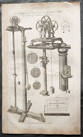
1798 W H Hall Large Antique Print of Atwood's Machine, Mechanical Laws of Motion
- Title : Atwoods Apparatus for Experiments on Accelerated Motion....Halls Encyclopedia...C. Cooke...
- Condition: (A) Very Good Condition
- Ref: 90676
- Size: 15in x 9in (380mm x 230mm)
- Date: 1798
Description:
This large original copper-plate engraved antique print was was published by William Henry Hall in the 1798 edition of The new royal encyclopedia; or, complete modern universal dictionary of arts and sciences on a new and improved plan.... printed by Charles Cooke, London.
General Definitions:
Paper thickness and quality: - Heavy and stable
Paper color : - off white
Age of map color: -
Colors used: -
General color appearance: -
Paper size: - 15in x 9in (380mm x 230mm)
Plate size: - 15in x 9in (380mm x 230mm)
Margins: - Min 1/2in (10mm)
Imperfections:
Margins: - Age toning
Plate area: - Light age toning
Verso: - Age toning
Background:
The Atwood machine (or Atwoods machine) was invented in 1784 by the English mathematician George Atwood as a laboratory experiment to verify the mechanical laws of motion with constant acceleration. Atwoods machine is a common classroom demonstration used to illustrate principles of classical mechanics.
The ideal Atwood machine consists of two objects of mass m1 and m2, connected by an inextensible massless string over an ideal massless pulley.
Both masses experience uniform acceleration. When m1 = m2, the machine is in neutral equilibrium regardless of the position of the weights.
Hall, William Henry
Hall was responsible for a significant publication in the middle of the 18th century The new royal encyclopedia; or, complete modern universal dictionary of arts and sciences on a new and improved plan . containing a digest and display of the whole theory and practice of the liberal and mechanical arts comprising a general repository of ancient and modern literature . including all the material information that is contained in Chamber s Cyclopedia, the Encyclopædia Britannica, and the French Encyclopædie . first published in 1788 going into many re-issues over the next 50 years.
The three volume set contained 153 copper-plate prints and maps, including some folding maps. Contained many brief encyclopedic entries in alphabetical orders plus longer, mainly illustrated, sections (systems or treatises) on a variety of subjects: Aerology; Aerostation (hot air balloons); Agriculture; Algebra; Amphibiology; Anatomy; Annuities; Architecture; Arithmetic; Astronomy (includes plates of telescopes); Book-Keeping; Botany; Brewing; Chronology; Chymistry; Comparative Anatomy; Concology; Dialling; Distillation; Drawing; Earth; Earthquakes; Electricity; Entomology; Farriery; Fencing; Fluxions; Fortification; Gardening; Geography (this section includes six folding maps); Geometry; Globes; Grammar; Heraldry; Hydrostatics and Hydraulics (one plate included a diving bell); Icthyology; Knighthood; Logic; Mammalia (included a plate showing whales); Mechanics; Medicine; Mensuration and Gauging; Miscroscopic Apparatus (microscopes); Midwifery; Military Affairs; Music; Natural History; Naval Affairs; Navigation (includes a folding map showing Cooks voyages); Optics; Oratory; Ornithology; Peerage; Perspective; Pneumatics; Projectiles; Steam Engines; Surgery; Surveying; Trigonometry; Vermeology; Volcanos; and War. Hard to find a complete set, as many have been broken up for their handsome copper plate engravings and maps.
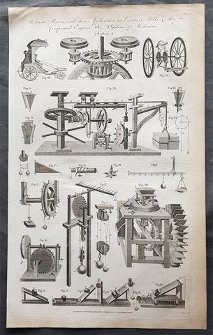
1798 W H Hall Large Antique Print of Drive Trains Cogs Pulleys for Cranes, Mills
- Title : Mechanical Powers with their Applications in Cranes, Mills & other compound Engines....Halls Encyclopedia...C. Cooke...
- Condition: (A) Very Good Condition
- Ref: 90674
- Size: 15in x 9in (380mm x 230mm)
- Date: 1798
Description:
This large original copper-plate engraved antique print was was published by William Henry Hall in the 1798 edition of The new royal encyclopedia; or, complete modern universal dictionary of arts and sciences on a new and improved plan.... printed by Charles Cooke, London.
General Definitions:
Paper thickness and quality: - Heavy and stable
Paper color : - off white
Age of map color: -
Colors used: -
General color appearance: -
Paper size: - 15in x 9in (380mm x 230mm)
Plate size: - 15in x 9in (380mm x 230mm)
Margins: - Min 1/2in (10mm)
Imperfections:
Margins: - Age toning
Plate area: - Light age toning
Verso: - Age toning
Background:
A crane is a type of machine, generally equipped with a hoist rope, wire ropes or chains, and sheaves, that can be used both to lift and lower materials and to move them horizontally. It is mainly used for lifting heavy things and transporting them to other places. The device uses one or more simple machines to create mechanical advantage and thus move loads beyond the normal capability of a human. Cranes are commonly employed in the transport industry for the loading and unloading of freight, in the construction industry for the movement of materials, and in the manufacturing industry for the assembling of heavy equipment.
The first known crane machine was the shadouf, a water-lifting device that was invented in ancient Mesopotamia (modern Iraq) and then appeared in ancient Egyptian technology. Construction cranes later appeared in ancient Greece, where they were powered by men or animals (such as donkeys), and used for the construction of buildings. Larger cranes were later developed in the Roman Empire, employing the use of human treadwheels, permitting the lifting of heavier weights. In the High Middle Ages, harbour cranes were introduced to load and unload ships and assist with their construction — some were built into stone towers for extra strength and stability. The earliest cranes were constructed from wood, but cast iron, iron and steel took over with the coming of the Industrial Revolution.
For many centuries, power was supplied by the physical exertion of men or animals, although hoists in watermills and windmills could be driven by the harnessed natural power. The first mechanical power was provided by steam engines, the earliest steam crane being introduced in the 18th or 19th century, with many remaining in use well into the late 20th century. Modern cranes usually use internal combustion engines or electric motors and hydraulic systems to provide a much greater lifting capability than was previously possible, although manual cranes are still utilized where the provision of power would be uneconomic.
Hall, William Henry
Hall was responsible for a significant publication in the middle of the 18th century The new royal encyclopedia; or, complete modern universal dictionary of arts and sciences on a new and improved plan . containing a digest and display of the whole theory and practice of the liberal and mechanical arts comprising a general repository of ancient and modern literature . including all the material information that is contained in Chamber s Cyclopedia, the Encyclopædia Britannica, and the French Encyclopædie . first published in 1788 going into many re-issues over the next 50 years.
The three volume set contained 153 copper-plate prints and maps, including some folding maps. Contained many brief encyclopedic entries in alphabetical orders plus longer, mainly illustrated, sections (systems or treatises) on a variety of subjects: Aerology; Aerostation (hot air balloons); Agriculture; Algebra; Amphibiology; Anatomy; Annuities; Architecture; Arithmetic; Astronomy (includes plates of telescopes); Book-Keeping; Botany; Brewing; Chronology; Chymistry; Comparative Anatomy; Concology; Dialling; Distillation; Drawing; Earth; Earthquakes; Electricity; Entomology; Farriery; Fencing; Fluxions; Fortification; Gardening; Geography (this section includes six folding maps); Geometry; Globes; Grammar; Heraldry; Hydrostatics and Hydraulics (one plate included a diving bell); Icthyology; Knighthood; Logic; Mammalia (included a plate showing whales); Mechanics; Medicine; Mensuration and Gauging; Miscroscopic Apparatus (microscopes); Midwifery; Military Affairs; Music; Natural History; Naval Affairs; Navigation (includes a folding map showing Cooks voyages); Optics; Oratory; Ornithology; Peerage; Perspective; Pneumatics; Projectiles; Steam Engines; Surgery; Surveying; Trigonometry; Vermeology; Volcanos; and War. Hard to find a complete set, as many have been broken up for their handsome copper plate engravings and maps.
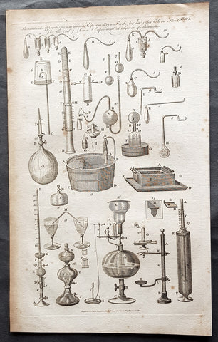
1798 W H Hall Large Antique Print of Various Pneumatic Air & Fluid Equipment
- Title : Pneumatical Apparatus for ascerting Experiments on fixed Air and other Fluids....Halls Encyclopedia...C. Cooke...
- Condition: (A) Very Good Condition
- Ref: 91138
- Size: 15in x 9in (380mm x 230mm)
- Date: 1798
Description:
This large original copper-plate engraved antique print was was published by William Henry Hall in the 1798 edition of The new royal encyclopedia; or, complete modern universal dictionary of arts and sciences on a new and improved plan.... printed by Charles Cooke, London.
General Definitions:
Paper thickness and quality: - Heavy and stable
Paper color : - off white
Age of map color: -
Colors used: -
General color appearance: -
Paper size: - 15in x 9in (380mm x 230mm)
Plate size: - 15in x 9in (380mm x 230mm)
Margins: - Min 1/2in (10mm)
Imperfections:
Margins: - Age toning
Plate area: - Light age toning
Verso: - Age toning
Background:
The origins of pneumatics can be traced back to the first century when ancient Greek mathematician Hero of Alexandria wrote about his inventions powered by steam or the wind.
German physicist Otto von Guericke (1602 to 1686) went a little further. He invented the vacuum pump, a device that can draw out air or gas from the attached vessel. He demonstrated the vacuum pump to separate the pairs of copper hemispheres using air pressures. The field of pneumatics has changed considerably over the years. It has moved from small handheld devices to large machines with multiple parts that serve different functions.
Hall, William Henry
Hall was responsible for a significant publication in the middle of the 18th century The new royal encyclopedia; or, complete modern universal dictionary of arts and sciences on a new and improved plan . containing a digest and display of the whole theory and practice of the liberal and mechanical arts comprising a general repository of ancient and modern literature . including all the material information that is contained in Chamber s Cyclopedia, the Encyclopædia Britannica, and the French Encyclopædie . first published in 1788 going into many re-issues over the next 50 years.
The three volume set contained 153 copper-plate prints and maps, including some folding maps. Contained many brief encyclopedic entries in alphabetical orders plus longer, mainly illustrated, sections (systems or treatises) on a variety of subjects: Aerology; Aerostation (hot air balloons); Agriculture; Algebra; Amphibiology; Anatomy; Annuities; Architecture; Arithmetic; Astronomy (includes plates of telescopes); Book-Keeping; Botany; Brewing; Chronology; Chymistry; Comparative Anatomy; Concology; Dialling; Distillation; Drawing; Earth; Earthquakes; Electricity; Entomology; Farriery; Fencing; Fluxions; Fortification; Gardening; Geography (this section includes six folding maps); Geometry; Globes; Grammar; Heraldry; Hydrostatics and Hydraulics (one plate included a diving bell); Icthyology; Knighthood; Logic; Mammalia (included a plate showing whales); Mechanics; Medicine; Mensuration and Gauging; Miscroscopic Apparatus (microscopes); Midwifery; Military Affairs; Music; Natural History; Naval Affairs; Navigation (includes a folding map showing Cooks voyages); Optics; Oratory; Ornithology; Peerage; Perspective; Pneumatics; Projectiles; Steam Engines; Surgery; Surveying; Trigonometry; Vermeology; Volcanos; and War. Hard to find a complete set, as many have been broken up for their handsome copper plate engravings and maps.
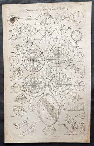
1798 W H Hall Large Antique Astronomical Print of Measurements & Calculations
- Title : Astronomy....Halls Encyclopedia...C. Cooke
- Condition: (A) Very Good Condition
- Ref: 01-7364
- Size: 15in x 9in (380mm x 230mm)
- Date: 1798
Description:
This large original copper-plate engraved antique print was was published by William Henry Hall in the 1798 edition of The new royal encyclopedia; or, complete modern universal dictionary of arts and sciences on a new and improved plan.... printed by Charles Cooke, London.
General Definitions:
Paper thickness and quality: - Heavy and stable
Paper color : - off white
Age of map color: -
Colors used: -
General color appearance: -
Paper size: - 15in x 9in (380mm x 230mm)
Plate size: - 15in x 9in (380mm x 230mm)
Margins: - Min 1/2in (10mm)
Imperfections:
Margins: - Age toning
Plate area: - Light age toning
Verso: - Age toning
Background:
During the Renaissance, Nicolaus Copernicus proposed a heliocentric model of the solar system. His work was defended by Galileo Galilei and expanded upon by Johannes Kepler. Kepler was the first to devise a system that correctly described the details of the motion of the planets around the Sun. However, Kepler did not succeed in formulating a theory behind the laws he wrote down. It was Isaac Newton, with his invention of celestial dynamics and his law of gravitation, who finally explained the motions of the planets. Newton also developed the reflecting telescope.
Improvements in the size and quality of the telescope led to further discoveries. The English astronomer John Flamsteed catalogued over 3000 stars. More extensive star catalogues were produced by Nicolas Louis de Lacaille. The astronomer William Herschel made a detailed catalog of nebulosity and clusters, and in 1781 discovered the planet Uranus, the first new planet found. The distance to a star was announced in 1838 when the parallax of 61 Cygni was measured by Friedrich Bessel.
During the 18–19th centuries, the study of the three-body problem by Leonhard Euler, Alexis Claude Clairaut, and Jean le Rond dAlembert led to more accurate predictions about the motions of the Moon and planets. This work was further refined by Joseph-Louis Lagrange and Pierre Simon Laplace, allowing the masses of the planets and moons to be estimated from their perturbations.
Significant advances in astronomy came about with the introduction of new technology, including the spectroscope and photography. Joseph von Fraunhofer discovered about 600 bands in the spectrum of the Sun in 1814–15, which, in 1859, Gustav Kirchhoff ascribed to the presence of different elements. Stars were proven to be similar to the Earths own Sun, but with a wide range of temperatures, masses, and sizes.
Hall, William Henry
Hall was responsible for a significant publication in the middle of the 18th century The new royal encyclopedia; or, complete modern universal dictionary of arts and sciences on a new and improved plan . containing a digest and display of the whole theory and practice of the liberal and mechanical arts comprising a general repository of ancient and modern literature . including all the material information that is contained in Chamber s Cyclopedia, the Encyclopædia Britannica, and the French Encyclopædie . first published in 1788 going into many re-issues over the next 50 years.
The three volume set contained 153 copper-plate prints and maps, including some folding maps. Contained many brief encyclopedic entries in alphabetical orders plus longer, mainly illustrated, sections (systems or treatises) on a variety of subjects: Aerology; Aerostation (hot air balloons); Agriculture; Algebra; Amphibiology; Anatomy; Annuities; Architecture; Arithmetic; Astronomy (includes plates of telescopes); Book-Keeping; Botany; Brewing; Chronology; Chymistry; Comparative Anatomy; Concology; Dialling; Distillation; Drawing; Earth; Earthquakes; Electricity; Entomology; Farriery; Fencing; Fluxions; Fortification; Gardening; Geography (this section includes six folding maps); Geometry; Globes; Grammar; Heraldry; Hydrostatics and Hydraulics (one plate included a diving bell); Icthyology; Knighthood; Logic; Mammalia (included a plate showing whales); Mechanics; Medicine; Mensuration and Gauging; Miscroscopic Apparatus (microscopes); Midwifery; Military Affairs; Music; Natural History; Naval Affairs; Navigation (includes a folding map showing Cooks voyages); Optics; Oratory; Ornithology; Peerage; Perspective; Pneumatics; Projectiles; Steam Engines; Surgery; Surveying; Trigonometry; Vermeology; Volcanos; and War. Hard to find a complete set, as many have been broken up for their handsome copper plate engravings and maps.
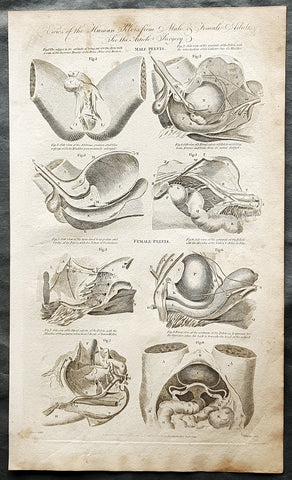
1798 W H Hall Large Antique Anatomical Print of Male & Female Pelvic X Section
- Title : Views of the Human Pelvis from Male & Female Adults....Halls Encyclopedia...C. Cooke 1795
- Condition: (A) Very Good Condition
- Ref: 90679
- Size: 15in x 9in (380mm x 230mm)
- Date: 1795
Description:
This large original copper-plate engraved antique print was engraved in 1795 - dated - and was published by William Henry Hall in the 1798 edition of The new royal encyclopedia; or, complete modern universal dictionary of arts and sciences on a new and improved plan.... printed by Charles Cooke, London.
General Definitions:
Paper thickness and quality: - Heavy and stable
Paper color : - off white
Age of map color: -
Colors used: -
General color appearance: -
Paper size: - 15in x 9in (380mm x 230mm)
Plate size: - 15in x 9in (380mm x 230mm)
Margins: - Min 1/2in (10mm)
Imperfections:
Margins: - Age toning
Plate area: - Light age toning
Verso: - Age toning
Background:
The reproductive system or genital system is a system of sex organs within an organism which work together for the purpose of sexual reproduction. Many non-living substances such as fluids, hormones, and pheromones are also important accessories to the reproductive system. Unlike most organ systems, the sexes of differentiated species often have significant differences. These differences allow for a combination of genetic material between two individuals, which allows for the possibility of greater genetic fitness of the offspring.
Hall, William Henry
Hall was responsible for a significant publication in the middle of the 18th century The new royal encyclopedia; or, complete modern universal dictionary of arts and sciences on a new and improved plan . containing a digest and display of the whole theory and practice of the liberal and mechanical arts comprising a general repository of ancient and modern literature . including all the material information that is contained in Chamber s Cyclopedia, the Encyclopædia Britannica, and the French Encyclopædie . first published in 1788 going into many re-issues over the next 50 years.
The three volume set contained 153 copper-plate prints and maps, including some folding maps. Contained many brief encyclopedic entries in alphabetical orders plus longer, mainly illustrated, sections (systems or treatises) on a variety of subjects: Aerology; Aerostation (hot air balloons); Agriculture; Algebra; Amphibiology; Anatomy; Annuities; Architecture; Arithmetic; Astronomy (includes plates of telescopes); Book-Keeping; Botany; Brewing; Chronology; Chymistry; Comparative Anatomy; Concology; Dialling; Distillation; Drawing; Earth; Earthquakes; Electricity; Entomology; Farriery; Fencing; Fluxions; Fortification; Gardening; Geography (this section includes six folding maps); Geometry; Globes; Grammar; Heraldry; Hydrostatics and Hydraulics (one plate included a diving bell); Icthyology; Knighthood; Logic; Mammalia (included a plate showing whales); Mechanics; Medicine; Mensuration and Gauging; Miscroscopic Apparatus (microscopes); Midwifery; Military Affairs; Music; Natural History; Naval Affairs; Navigation (includes a folding map showing Cooks voyages); Optics; Oratory; Ornithology; Peerage; Perspective; Pneumatics; Projectiles; Steam Engines; Surgery; Surveying; Trigonometry; Vermeology; Volcanos; and War. Hard to find a complete set, as many have been broken up for their handsome copper plate engravings and maps.
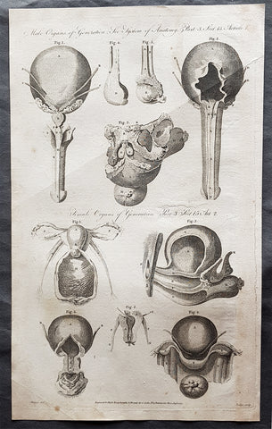
1795 William Henry Hall Large Antique Print of Male & Female Reproductive System
- Title : Male Organs of Generation; Female Organs of Generation...Halls Encyclopedia...C. Cooke 1795
- Condition: (A) Very Good Condition
- Ref: 01-7304
- Size: 15in x 9in (380mm x 230mm)
- Date: 1795
Description:
This large original copper-plate engraved antique print was engraved in 1795 - dated - and was published by William Henry Hall in the 1798 edition of The new royal encyclopedia; or, complete modern universal dictionary of arts and sciences on a new and improved plan.... printed by Charles Cooke, London.
General Definitions:
Paper thickness and quality: - Heavy and stable
Paper color : - off white
Age of map color: -
Colors used: -
General color appearance: -
Paper size: - 15in x 9in (380mm x 230mm)
Plate size: - 15in x 9in (380mm x 230mm)
Margins: - Min 1/2in (10mm)
Imperfections:
Margins: - Age toning
Plate area: - Light age toning
Verso: - Age toning
Background:
The reproductive system or genital system is a system of sex organs within an organism which work together for the purpose of sexual reproduction. Many non-living substances such as fluids, hormones, and pheromones are also important accessories to the reproductive system. Unlike most organ systems, the sexes of differentiated species often have significant differences. These differences allow for a combination of genetic material between two individuals, which allows for the possibility of greater genetic fitness of the offspring.
Hall, William Henry
Hall was responsible for a significant publication in the middle of the 18th century The new royal encyclopedia; or, complete modern universal dictionary of arts and sciences on a new and improved plan . containing a digest and display of the whole theory and practice of the liberal and mechanical arts comprising a general repository of ancient and modern literature . including all the material information that is contained in Chamber s Cyclopedia, the Encyclopædia Britannica, and the French Encyclopædie . first published in 1788 going into many re-issues over the next 50 years.
The three volume set contained 153 copper-plate prints and maps, including some folding maps. Contained many brief encyclopedic entries in alphabetical orders plus longer, mainly illustrated, sections (systems or treatises) on a variety of subjects: Aerology; Aerostation (hot air balloons); Agriculture; Algebra; Amphibiology; Anatomy; Annuities; Architecture; Arithmetic; Astronomy (includes plates of telescopes); Book-Keeping; Botany; Brewing; Chronology; Chymistry; Comparative Anatomy; Concology; Dialling; Distillation; Drawing; Earth; Earthquakes; Electricity; Entomology; Farriery; Fencing; Fluxions; Fortification; Gardening; Geography (this section includes six folding maps); Geometry; Globes; Grammar; Heraldry; Hydrostatics and Hydraulics (one plate included a diving bell); Icthyology; Knighthood; Logic; Mammalia (included a plate showing whales); Mechanics; Medicine; Mensuration and Gauging; Miscroscopic Apparatus (microscopes); Midwifery; Military Affairs; Music; Natural History; Naval Affairs; Navigation (includes a folding map showing Cooks voyages); Optics; Oratory; Ornithology; Peerage; Perspective; Pneumatics; Projectiles; Steam Engines; Surgery; Surveying; Trigonometry; Vermeology; Volcanos; and War. Hard to find a complete set, as many have been broken up for their handsome copper plate engravings and maps.
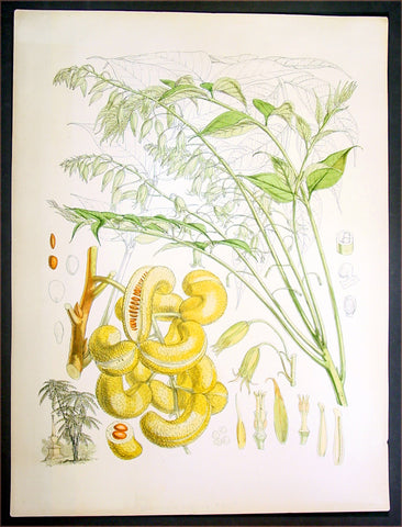
1855 Hooker Fitch Antique Botanical Print China Mao Er Shi Goat Horn
- Title : Decaisnea Insignis H. F & T
- Date : 1855
- Condition: (A+) Fine Condition
- Ref: 80767
- Size: 20in x 15in (510mm x 380mm)
Description:
This beautifully hand coloured original 1855 antique lithograph print of the Decaisnea insignis or by its Chinese name Mao Er Shi (Transcribed Chinese) cat faeces or goat horns, that grows in China & SE Asia, is one of a series of illustrations made for J. F. Cathcart of the Bengal Civil Service by Sir Joseph Dalton Hooker for the 1855 publication of Illustrations of Himalayan plants.
This publication contained 24 coloured plates all superbly engraved and hand coloured. The plates were executed by W. H. Fitch, analysed by the famous botanist J. D. Hooker.
Decaisnea insignis Mao Er Shi (Transcribed Chinese - Cat faeces or Goat Horns - is a genus of flowering plant in the family Lardizabalaceae, native to eastern Asia, from China west to Nepal and south to Myanmar.
The genus comprises one or two species, depending on taxonomic opinion. Decaisnea insignis (Griffith) Hook.f. & Thomson was described from Nepal, and is sometimes restricted to the plants occurring in the Himalaya, with Chinese plants distinguished asDecaisnea fargesii Franchet. The only cited distinction (e.g. Bean 1973, Rushforth 1999) between the plants from the two regions is the fruit colour, yellow-green in D. insignis and bluish in D. fargesii. This is of little significance and the two are now combined under the older name D. insignis by some authors (e.g. Flora of China).
Sir Joseph Dalton Hooker (1817 – 1911) was one of the greatest British botanists and explorers of the 19th century. Hooker was one of the founders of geographical botany, and Charles Darwin's closest friend. He was Director of the Royal Botanical Gardens, Kew, for twenty years, in succession to his father, William Jackson Hooker, and was awarded the highest honours of British science.
On 11 November 1847 Hooker left England for his three year long Himalayan expedition; he would be the first European to collect plants in the Himalaya.
By his travels and his publications, Hooker built up a high scientific reputation at home. In 1855 he was appointed Assistant-Director of the Royal Botanic Gardens, Kew, and in 1865 he succeeded his father as full Director, holding the post for twenty years. Under the directorship of father and son Hooker, the Royal Botanical gardens of Kew rose to world renown. At the age of thirty, Hooker was elected a fellow of the Royal Society, and in 1873 he was chosen its President (till 1877). He received three of its medals: the Royal Medal in 1854, the Copley in 1887 and the Darwin Medal in 1892. He continued to intersperse work at Kew with foreign exploration and collecting. His journeys to Palestine, Morocco and the United States all produced valuable information and specimens for Kew.
He started the series Flora Indica in 1855, together with Thomas Thompson. Their botanical observations and the publication of the Rhododendrons of Sikkim-Himalaya (1849–51), formed the basis of elaborate works on the rhododendrons of the Sikkim Himalaya and on the flora of India. His works were illustrated with lithographs by Walter Hood Fitch.
Walter Hood Fitch (1817 - 1892) was a botanist and botanical artist. He was born in Glasgow, Scotland.
Fitch was involved in fabric printing from the age of 17 and took to botanical art after being discovered by William Jackson Hooker, the editor of Curtis's Botanical Magazine. Hooker was a Professor of Botany at the University of Glasgow, and a competent botanical artist in his own right.
Fitch's important works are his illustrations for W. J. Hooker's A Century of Orchidaceous Plants (1851), and for James Bateman's A Monograph of Odontoglossum (1864-74). He also created around 500 plates for Hooker's Icones Plantarum (1836-76). Some of his most notable work was for George Bentham and W.J. Hooker's Handbook of the British Flora (1865). When Joseph Dalton Hooker returned from his travels in India, Fitch prepared lithographs from Hooker's sketches for his Rhododendrons of Sikkim Himalaya (1849-51) and, from the drawings of Indian artists, for his Illustrations of Himalayan Plants (1855).
A dispute over pay with Joseph Dalton Hooker ended Fitch's service to both the Botanical Magazine and Kew although he was much sought after and remained active as a botanical artist until 1888. Works during this period included Henry John Elwes's Monograph of the Genus Lilium (1877-80). (Ref: M&B; Tooley)
General Description:
Paper thickness and quality: - Heavy & stable
Paper color: - White
Age of map color: - Early
Colors used: - Red, pink, green, brown
General color appearance: - Authentic
Paper size: - 20in x 15in (510mm x 380mm)
Margins: - Min 1/2in (12mm)
Imperfections:
Margins: - Light soiling top left & bottom of margin
Plate area: - None
Verso: - None
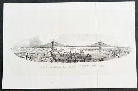
1869 DT Valentine Antique Print of the Proposed East River or Brooklyn Bridge NY
- Title : Contemplated East River Bridge
- Size: 11in x 7 1/2in (280mm x 190mm)
- Condition: (A+) Fine Condition
- Date : 1869
- Ref #: 93310
Description:
This original antique lithograph print, a view of the proposed Brooklyn Bridge in 1869 by George Hayward was published in the 1869 edition of D T Valentines Manual of the Corporation of the City of New York or Valentines Manual.
The Brooklyn Bridge started construction in 1869 and was completed fourteen years later in 1883. It was originally called the New York and Brooklyn Bridge and the East River Bridge, but it was later dubbed the Brooklyn Bridge. However, it was not named as such until the city government passed a law to that effect in 1915. Over the years, the Brooklyn Bridge has undergone several reconfigurations; it formerly carried horse-drawn vehicles and elevated railway lines, but now carries vehicular, pedestrian, and bicycle traffic. Commercial vehicles are banned from the bridge.
General Definitions:
Paper thickness and quality: - Heavy and stable
Paper color : - off white
Age of map color: -
Colors used: -
General color appearance: -
Paper size: - 11in x 7 1/2in (280mm x 190mm)
Plate size: - 11in x 7 1/2in (280mm x 190mm)
Margins: - Min 1/2in (12mm)
Imperfections:
Margins: - None
Plate area: - Folds as issued
Verso: - None
Background:
Manual of the Corporation of the City of New York or Valentines Manuals, published for nearly 30 years, contained hundreds of rare beautifully hand coloured contemporary and historical lithograph maps and views of New York City.
Valentine, David Thomas 1801 - 1869
As the Clerk of the Common Council of New York City, Valentine edited and published a series of books on the history and contemporary facts of New York City entitled Manual of the Corporation Of The City of New York. They became know as Valentines Manuals with updates published annually, between 1841 & 1870. Valentine used his manuals to produce some of the rarest and most important maps & views of the city of New York, some of which occasionally appear on the market. His contribution to the historical record of New York city cannot be over stated.
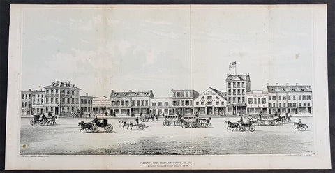
1861 DT Valentine Antique Print View of Broadway New York, America in 1840
- Title : View of Broadway NY between Howard & Grans Streets, 1840
- Size: 13in x 7in (330mm x 180mm)
- Condition: (A+) Fine Condition
- Date : 1861
- Ref #: 93168
Description:
This original antique lithograph print, a view of Broadway New York in 1840, by George Hayward was published in the 1861 edition of D T Valentines Manual of the Corporation of the City of New York or Valentines Manual.
General Definitions:
Paper thickness and quality: - Heavy and stable
Paper color : - off white
Age of map color: -
Colors used: -
General color appearance: -
Paper size: - 13in x 7in (330mm x 180mm)
Plate size: - 13in x 7in (330mm x 180mm)
Margins: - Min 1/4in (5mm)
Imperfections:
Margins: - Light age toning
Plate area: - Folds as issued
Verso: - None
Background:
Manual of the Corporation of the City of New York or Valentines Manuals, published for nearly 30 years, contained hundreds of rare beautifully hand coloured contemporary and historical lithograph maps and views of New York City.
Valentine, David Thomas 1801 - 1869
As the Clerk of the Common Council of New York City, Valentine edited and published a series of books on the history and contemporary facts of New York City entitled Manual of the Corporation Of The City of New York. They became know as Valentines Manuals with updates published annually, between 1841 & 1870. Valentine used his manuals to produce some of the rarest and most important maps & views of the city of New York, some of which occasionally appear on the market. His contribution to the historical record of New York city cannot be over stated.
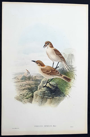
1850 John Gould Large Antique Bird Print of The Tibetan or Humes Ground-Tit
- Title : Podoces Humilis, Hume...J Gould & W Hart del et Lith....Walter Imp.
- Size: 21 1/2in x 14 1/2in (490mm x 370mm)
- Condition: (A+) Fine Condition
- Date : 1850
- Ref #: 23189
Description:
This finely engraved superbly hand coloured original antique bird print of Podoces Humilis or the Tibetan ground-tit or Humes ground-tit, was published by John Gould in the 1850 release of his illustrated ornithology book The Birds of Asia. Lithography by J Gould, HC Richter & W. Hart publication by Hullamdel, Walton & Walter
General Definitions:
Paper thickness and quality: - Heavy and stable
Paper color : - off white
Age of map color: - Original
Colors used: - Yellow, green, blue, pink
General color appearance: - Authentic
Paper size: - 21 1/2in x 14 1/2in (490mm x 370mm)
Plate size: - 21 1/2in x 14 1/2in (490mm x 370mm)
Margins: - Min 1/2in (12mm)
Imperfections:
Margins: - Very light age toning in margins
Plate area: - None
Verso: - None
Background:
One of the great bird artists of all time, John Gould created over 3,000 plates of birds in over 40 volumes.
Around 1830, while working as taxidermist for the Zoological Society of London, he received a shipment of exotic bird skins from the Himalayas. Soon after, he published A Century of Birds from the Himalaya Moutains.
The success of this work, along with the Birds of Europe (1832-37) and a Monograph of the Ramphastidae [Toucans] allowed him to travel to Australia and New Guinea. Among Gould\'s better known works are the Birds of Australia (1849-69), the Birds of Asia (1850-83), and Birds of Great Britain (1862-73).
Though Gould himself sketched most of his plates, other artists such as his wife Elizabeth, Edward Lear, Joseph Wolf, William Hart and Henry C. Richter finished them. Gould\'s plates are highly esteemed for their composition, accurate detail, and coloring. (Ref: Methuen)
1712 J Senex & W Whiston Large Antique Astronomy Print of Planets & Solar System
- Title : A Scheme of the Solar System with the Orbits of the Planets and Comets belonging thereto, Described from Dr. Halley\'s accurate Table of Comets Philosoph, Transact. No. 297. Founded on Sr. Isaac Newton\'s wonderful discoveries By Wm. Whiston M.A.
- Size: 27in x 21in (585mm x 520mm)
- Condition: (B) Good Condition
- Date : 1712
- Ref #: 80773
Description:
This large original important copper plate engraved antique map of the Planets & Solar System according to Edmund Halley, Isaac Newton & William Whiston by John Senex in 1712, was published in his Elephant Folio Atlas.
This map is rare and is unfortunately damaged, not unusual for these large maps. Approx 4in strip from the left side of the map & approx 1in from the bottom of the map is missing and has been mounted on contemporary 18th century paper. Still the majority of the map remains and is still a fascinating look into our knowledge of Solar System at the beginning of the 18th century. At the moment there a couple for sale online selling for between $1500 - $5000
General Definitions:
Paper thickness and quality: - Heavy and stable
Paper color : - off white
Age of map color: -
Colors used: -
General color appearance: -
Paper size: - 27in x 21in (585mm x 520mm)
Plate size: - 27in x 21in (585mm x 520mm)
Margins: - Min 1/2in (12mm)
Imperfections:
Margins: - Approx 4in strip from the left side of the map is missing
Plate area: - Two repairs to top of image
Verso: - Repairs as noted
Background:
A large and impressive chart of the solar system, paying particular attention to the motions of the planetary bodies and the paths of comets. The chart was originally engraved in 1712 by Senex to accompany the lectures of the controversial theologian, astronomer, and polymath William Whiston. The chart was issued again in 1720 by Senex alone, and finally by Bowles and Sayer in the 1760s. The System is shown as a number of concentric orbits with the Sun at centre, criss-crossed by the broad elliptical paths of a number of comets. At top, the planets are shown pictorially, clumped together in an attempt to demonstrate scale. As the chart was engraved at the beginning of the eighteenth century, the outer planets past Saturn are not included. Earths moon is accorded an honorary spot among the planets, while the moons of the other planets are shown in the grand scheme as Satellites. The alchemical symbols for the zodiac are included along the outside ring of the System, and the chart is absolutely covered by explanatory text.
William Whiston (1667-1752) was an English mathematician, theologian, historian and religious writer. Born in Leicestershire, Whiston was a leading figure in popularising the ideas of Sir Issac Newton, who was his mentor and teacher. Whiston was a professor of mathematics at the University of Cambridge but was expelled from his position in 1710 due to his unorthodox religious beliefs and views. Whiston was a believer of Arianism, the idea that Christ is subordinate to God, the concept of Christ is based on the belief that the Son of God did not always exist but was begotten by God the Father. He also rejected the notion of eternal torment in hellfire. What especially placed him against church authorities, was he viewed the Trinity as a lie after extensive personal research convinced him the origin of the Trinity teaching to be pagan. Whiston wrote A New Theory of the Earth, published in 1696, in which he presented a description of the divine creation of the Earth, postulating that the earth originated from the atmosphere of a comet.
1842 William Mather Antique Cross Section Geology Print The Island of New York
- Title : Geological Section, on the Island of New York.....
- Size: 11 1/2in x 9in (280mm x 230mm)
- Condition: (A+) Fine Condition
- Date : 1842
- Ref #: 93063
Description:
This original hand coloured antique lithograph of 3 cross sectional geological maps, views on the Island of New York by the Endicott company, was published in the 1842 edition of William Mathers Geology of New York
General Definitions:
Paper thickness and quality: - Heavy and stable
Paper color : - off white
Age of map color: - Original
Colors used: - Yellow
General color appearance: - Authentic
Paper size: - 11 1/2in x 9in (280mm x 230mm)
Plate size: - 11 1/2in x 9in (280mm x 230mm)
Margins: - Min 1/2in (12mm)
Imperfections:
Margins: - None
Plate area: - None
Verso: - None
Background:
In 1836 William Williams Mather was appointed geologist of the first district, or 21 counties, of New York State. This work required seven years, and his final report was a quarto of 671 pages, with forty-six colored plates, a great undertaking for the early days of geological research. From 1837 to 1840, he also superintended the geological survey of the state of Ohio, and made elaborate reports (2 vols., Columbus, 1838). In 1838/9 he made a report upon the geological reconnaissance of the state of Kentucky.
Mather, William W. 1804 - 1859
Mather was an important American geologist and natural historian. Mather was born in Brooklyn, Connecticut to an old New England family. In 1823, as a young man, he entered the West Point military academy after which he served as a 2nd Lieutenant in the Seventh Infantry. His interest in Chemistry and mineralogy soon called him back to West Point where he acted as an Assistant Professor of Geology. After resigning from the Army in 1834 with a rank of 1st Lieutenant, Mather accepted a position as Professor of Chemistry at the University of Louisiana. Later he was employed as Professor of Natural History and Sciences at the University of Ohio, was appointed Geologist of the First Geological District of New York for Governor William H. Seward, and was the State Geologist of both Ohio and Kentucky. In 1847 Mather became president of the University of Ohio. During his long career Mather made copious notes regarding his geological explorations, published profusely, and had a lively and extensive correspondence - much of which remains accessible to this day. Mather reports on one humorous incident in Long Island where, while collecting rock specimens, he had a run-in with a local farmer. The famer, observing the care with which Mather collected and cataloged his rock specimens, assumed that Mather had, in fact, discovered gold! Mather died in Columbus, Ohio on February 26, 1859. Today the W.W. Mather Medal is an important Geologic Reserach commendation. (Collections of the Minnesota Historical Society, p. 133.)
Endicott and Company (fl. c. 1828 - 1891) was a New York based family run lithography firm that flourished throughout the 19th century. The firm was founded by George and William Endicott, brothers who were born in Canton, Massachusetts. George Endicott (June 14, 1802 - 1848) trained as a lithographer under Pendleton Lithography from January of 1826. He later worked as superintendent of Senefelder Company until the summer of 1828. Afterwards, in 1830, he relocated to Baltimore and partnered with Moses Swett. Endicott and Swett relocated to New York City in December of 1831. They remained partners until July of 1834 when the relationship dissolved. George set up shop on his own account at 359 Broadway. William Endicott (1815 - 1851), George\\\'s younger brother of 14 years, joined the firm in 1840 and was made a partner in 1845, after which the name of the firm was changed to G. and W. Endicott. George Endicott died shortly afterward, in 1848, but William continued operating the firm as William Endicott and Co. until his own 1851 death at just 35 years. The firm was carried on by his widow Sara Munroe Endicott until it was taken over by her son, Francis Endicott, who ran the firm from 1852 to 1886. George Endicott, Jr. subsequently ran the firm from 1887 to 1891. Peters, in his important work on American lithography America on Stone writes \\\"it is hard to summarize the Endicotts. They did everything and did it well . . . [they] worked with and for Currier and Ives, yet in spite of all that much of their work lacks real individuality.\\\" The Endicott firm was responsible for many 19th century views and plans of New York City and state as well as plans of Sacramento, California, and the Midwest.
1842 William Mather Antique Geology Print Hudson River Lakes George to Champlain
- Title : Section from Lake George by Whitehall to E Poultney in VT
- Size: 11 1/2in x 9in (280mm x 230mm)
- Condition: (A+) Fine Condition
- Date : 1842
- Ref #: 93064
Description:
This original hand coloured antique lithograph cross sectional geological map,a view along the Hudson River from Lake George in NY to Lake Champlain Vermont by the Endicott company, was published in the 1842 edition of William Mathers Geology of New York
General Definitions:
Paper thickness and quality: - Heavy and stable
Paper color : - off white
Age of map color: - Original
Colors used: - Yellow
General color appearance: - Authentic
Paper size: - 11 1/2in x 9in (280mm x 230mm)
Plate size: - 11 1/2in x 9in (280mm x 230mm)
Margins: - Min 1/2in (12mm)
Imperfections:
Margins: - None
Plate area: - None
Verso: - None
Background:
In 1836 William Williams Mather was appointed geologist of the first district, or 21 counties, of New York State. This work required seven years, and his final report was a quarto of 671 pages, with forty-six colored plates, a great undertaking for the early days of geological research. From 1837 to 1840, he also superintended the geological survey of the state of Ohio, and made elaborate reports (2 vols., Columbus, 1838). In 1838/9 he made a report upon the geological reconnaissance of the state of Kentucky.
Mather, William W. 1804 - 1859
Mather was an important American geologist and natural historian. Mather was born in Brooklyn, Connecticut to an old New England family. In 1823, as a young man, he entered the West Point military academy after which he served as a 2nd Lieutenant in the Seventh Infantry. His interest in Chemistry and mineralogy soon called him back to West Point where he acted as an Assistant Professor of Geology. After resigning from the Army in 1834 with a rank of 1st Lieutenant, Mather accepted a position as Professor of Chemistry at the University of Louisiana. Later he was employed as Professor of Natural History and Sciences at the University of Ohio, was appointed Geologist of the First Geological District of New York for Governor William H. Seward, and was the State Geologist of both Ohio and Kentucky. In 1847 Mather became president of the University of Ohio. During his long career Mather made copious notes regarding his geological explorations, published profusely, and had a lively and extensive correspondence - much of which remains accessible to this day. Mather reports on one humorous incident in Long Island where, while collecting rock specimens, he had a run-in with a local farmer. The famer, observing the care with which Mather collected and cataloged his rock specimens, assumed that Mather had, in fact, discovered gold! Mather died in Columbus, Ohio on February 26, 1859. Today the W.W. Mather Medal is an important Geologic Reserach commendation. (Collections of the Minnesota Historical Society, p. 133.)
Endicott and Company (fl. c. 1828 - 1891) was a New York based family run lithography firm that flourished throughout the 19th century. The firm was founded by George and William Endicott, brothers who were born in Canton, Massachusetts. George Endicott (June 14, 1802 - 1848) trained as a lithographer under Pendleton Lithography from January of 1826. He later worked as superintendent of Senefelder Company until the summer of 1828. Afterwards, in 1830, he relocated to Baltimore and partnered with Moses Swett. Endicott and Swett relocated to New York City in December of 1831. They remained partners until July of 1834 when the relationship dissolved. George set up shop on his own account at 359 Broadway. William Endicott (1815 - 1851), George\\\'s younger brother of 14 years, joined the firm in 1840 and was made a partner in 1845, after which the name of the firm was changed to G. and W. Endicott. George Endicott died shortly afterward, in 1848, but William continued operating the firm as William Endicott and Co. until his own 1851 death at just 35 years. The firm was carried on by his widow Sara Munroe Endicott until it was taken over by her son, Francis Endicott, who ran the firm from 1852 to 1886. George Endicott, Jr. subsequently ran the firm from 1887 to 1891. Peters, in his important work on American lithography America on Stone writes \\\"it is hard to summarize the Endicotts. They did everything and did it well . . . [they] worked with and for Currier and Ives, yet in spite of all that much of their work lacks real individuality.\\\" The Endicott firm was responsible for many 19th century views and plans of New York City and state as well as plans of Sacramento, California, and the Midwest.
1842 William Mather Antique Geology Print of Hudson River, Sullivan County, NY
- Title : Section in Sullivan Co. Catskill Mt Rocks
- Size: 11 1/2in x 9in (280mm x 230mm)
- Condition: (A+) Fine Condition
- Date : 1842
- Ref #: 93067
Description:
This original hand coloured antique lithograph cross sectional geological map,a view along the Hudson River in Sullivan County, New York by the Endicott company, was published in the 1842 edition of William Mathers Geology of New York
Sullivan County is a county in the U.S. state of New York.
When the Province of New York established its first twelve counties in 1683, the present Sullivan County was part of Ulster County. In 1809, Sullivan County was split from Ulster County.
In the late 19th century, the Industrial Revolution and the advent of factories driven by water power along the streams and rivers led to an increase in population attracted to the jobs. Hamlets enlarged into towns. As industry restructured, many of those jobs left before the middle of the twentieth century. The economy changed again after that, shifting to a more tourist-based variety and benefiting from resorts established by European Jewish immigrants and their descendants in what became called the Borscht Belt of the 20th century. Resort hotels featured a wide variety of entertainers, some nationally known. At the beginning of this period, visitors traveled to the area by train, and later by automobile. The areas natural resources also provided a setting for numerous summer camps frequented by the children of immigrants and their descendants.
General Definitions:
Paper thickness and quality: - Heavy and stable
Paper color : - off white
Age of map color: - Original
Colors used: - Yellow
General color appearance: - Authentic
Paper size: - 11 1/2in x 9in (280mm x 230mm)
Plate size: - 11 1/2in x 9in (280mm x 230mm)
Margins: - Min 1/2in (12mm)
Imperfections:
Margins: - None
Plate area: - None
Verso: - None
Background:
In 1836 William Williams Mather was appointed geologist of the first district, or 21 counties, of New York State. This work required seven years, and his final report was a quarto of 671 pages, with forty-six colored plates, a great undertaking for the early days of geological research. From 1837 to 1840, he also superintended the geological survey of the state of Ohio, and made elaborate reports (2 vols., Columbus, 1838). In 1838/9 he made a report upon the geological reconnaissance of the state of Kentucky.
Mather, William W. 1804 - 1859
Mather was an important American geologist and natural historian. Mather was born in Brooklyn, Connecticut to an old New England family. In 1823, as a young man, he entered the West Point military academy after which he served as a 2nd Lieutenant in the Seventh Infantry. His interest in Chemistry and mineralogy soon called him back to West Point where he acted as an Assistant Professor of Geology. After resigning from the Army in 1834 with a rank of 1st Lieutenant, Mather accepted a position as Professor of Chemistry at the University of Louisiana. Later he was employed as Professor of Natural History and Sciences at the University of Ohio, was appointed Geologist of the First Geological District of New York for Governor William H. Seward, and was the State Geologist of both Ohio and Kentucky. In 1847 Mather became president of the University of Ohio. During his long career Mather made copious notes regarding his geological explorations, published profusely, and had a lively and extensive correspondence - much of which remains accessible to this day. Mather reports on one humorous incident in Long Island where, while collecting rock specimens, he had a run-in with a local farmer. The famer, observing the care with which Mather collected and cataloged his rock specimens, assumed that Mather had, in fact, discovered gold! Mather died in Columbus, Ohio on February 26, 1859. Today the W.W. Mather Medal is an important Geologic Reserach commendation. (Collections of the Minnesota Historical Society, p. 133.)
Endicott and Company (fl. c. 1828 - 1891) was a New York based family run lithography firm that flourished throughout the 19th century. The firm was founded by George and William Endicott, brothers who were born in Canton, Massachusetts. George Endicott (June 14, 1802 - 1848) trained as a lithographer under Pendleton Lithography from January of 1826. He later worked as superintendent of Senefelder Company until the summer of 1828. Afterwards, in 1830, he relocated to Baltimore and partnered with Moses Swett. Endicott and Swett relocated to New York City in December of 1831. They remained partners until July of 1834 when the relationship dissolved. George set up shop on his own account at 359 Broadway. William Endicott (1815 - 1851), George\\\'s younger brother of 14 years, joined the firm in 1840 and was made a partner in 1845, after which the name of the firm was changed to G. and W. Endicott. George Endicott died shortly afterward, in 1848, but William continued operating the firm as William Endicott and Co. until his own 1851 death at just 35 years. The firm was carried on by his widow Sara Munroe Endicott until it was taken over by her son, Francis Endicott, who ran the firm from 1852 to 1886. George Endicott, Jr. subsequently ran the firm from 1887 to 1891. Peters, in his important work on American lithography America on Stone writes \\\"it is hard to summarize the Endicotts. They did everything and did it well . . . [they] worked with and for Currier and Ives, yet in spite of all that much of their work lacks real individuality.\\\" The Endicott firm was responsible for many 19th century views and plans of New York City and state as well as plans of Sacramento, California, and the Midwest.
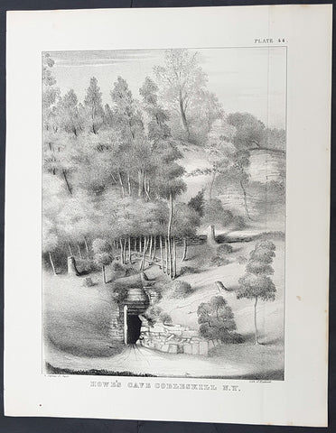
1842 William Mather Antique Geology Print Entrance to Howes Cavern Cobleskill NY
- Title : Howes Cave Cobleskill N.Y.
- Size: 11 1/2in x 9in (280mm x 230mm)
- Condition: (A+) Fine Condition
- Date : 1842
- Ref #: 93069
Description:
This original antique lithograph of the entrance to Howes Cavern in Cobleskill, New York by the Endicott company, was published in the 1842 edition of William Mathers Geology of New York
A beautiful black and white lithograph, the entrance to the cave is situated in the foreground, with what appears to be stones and beams marking the way in. Trees cover the hillside, creating the image of a wild, untamed wilderness. Today, Howes Cave is known by another name: Howe Caverns and is located in the town of Howes Cave in Schoharie County. Howe Caverns is the second most visited natural attraction in New York State, following Niagara Falls.
General Definitions:
Paper thickness and quality: - Heavy and stable
Paper color : - off white
Age of map color: -
Colors used: -
General color appearance: -
Paper size: - 11 1/2in x 9in (280mm x 230mm)
Plate size: - 11 1/2in x 9in (280mm x 230mm)
Margins: - Min 1/2in (12mm)
Imperfections:
Margins: - None
Plate area: - None
Verso: - None
Background:
In 1836 William Williams Mather was appointed geologist of the first district, or 21 counties, of New York State. This work required seven years, and his final report was a quarto of 671 pages, with forty-six colored plates, a great undertaking for the early days of geological research. From 1837 to 1840, he also superintended the geological survey of the state of Ohio, and made elaborate reports (2 vols., Columbus, 1838). In 1838/9 he made a report upon the geological reconnaissance of the state of Kentucky.
Mather, William W. 1804 - 1859
Mather was an important American geologist and natural historian. Mather was born in Brooklyn, Connecticut to an old New England family. In 1823, as a young man, he entered the West Point military academy after which he served as a 2nd Lieutenant in the Seventh Infantry. His interest in Chemistry and mineralogy soon called him back to West Point where he acted as an Assistant Professor of Geology. After resigning from the Army in 1834 with a rank of 1st Lieutenant, Mather accepted a position as Professor of Chemistry at the University of Louisiana. Later he was employed as Professor of Natural History and Sciences at the University of Ohio, was appointed Geologist of the First Geological District of New York for Governor William H. Seward, and was the State Geologist of both Ohio and Kentucky. In 1847 Mather became president of the University of Ohio. During his long career Mather made copious notes regarding his geological explorations, published profusely, and had a lively and extensive correspondence - much of which remains accessible to this day. Mather reports on one humorous incident in Long Island where, while collecting rock specimens, he had a run-in with a local farmer. The famer, observing the care with which Mather collected and cataloged his rock specimens, assumed that Mather had, in fact, discovered gold! Mather died in Columbus, Ohio on February 26, 1859. Today the W.W. Mather Medal is an important Geologic Reserach commendation. (Collections of the Minnesota Historical Society, p. 133.)
Endicott and Company (fl. c. 1828 - 1891) was a New York based family run lithography firm that flourished throughout the 19th century. The firm was founded by George and William Endicott, brothers who were born in Canton, Massachusetts. George Endicott (June 14, 1802 - 1848) trained as a lithographer under Pendleton Lithography from January of 1826. He later worked as superintendent of Senefelder Company until the summer of 1828. Afterwards, in 1830, he relocated to Baltimore and partnered with Moses Swett. Endicott and Swett relocated to New York City in December of 1831. They remained partners until July of 1834 when the relationship dissolved. George set up shop on his own account at 359 Broadway. William Endicott (1815 - 1851), George\\\'s younger brother of 14 years, joined the firm in 1840 and was made a partner in 1845, after which the name of the firm was changed to G. and W. Endicott. George Endicott died shortly afterward, in 1848, but William continued operating the firm as William Endicott and Co. until his own 1851 death at just 35 years. The firm was carried on by his widow Sara Munroe Endicott until it was taken over by her son, Francis Endicott, who ran the firm from 1852 to 1886. George Endicott, Jr. subsequently ran the firm from 1887 to 1891. Peters, in his important work on American lithography America on Stone writes \\\"it is hard to summarize the Endicotts. They did everything and did it well . . . [they] worked with and for Currier and Ives, yet in spite of all that much of their work lacks real individuality.\\\" The Endicott firm was responsible for many 19th century views and plans of New York City and state as well as plans of Sacramento, California, and the Midwest.
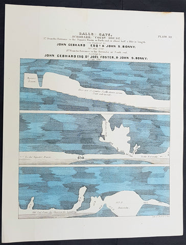
1842 William Mather Antique Geology Print of Balls Cave, Schoharie County, NY
- Title : Balls Cave, Schoharie Court House....
- Size: 11 1/2in x 9in (280mm x 230mm)
- Condition: (A+) Fine Condition
- Date : 1842
- Ref #: 93065
Description:
This original antique coloured lithograph plate depicting a cross sectional geological part view Balls Cave, Schoharie County, New York state by the Endicott company, was published in the 1842 edition of William Mathers Geology of New York
Balls Cave was located in Schoharie County about two miles from the courthouse in Schoharie. It was discovered and explored by John Gebhard and John Bonny in 1831 and 1832. Soon after the cave was discovered, Gebhard and Bonny provided a description of the cave which was subsequently published in the newspapers of the day. A stream ran through the cave, so Gebhard and Bonny kept a boat for use during their explorations. Per Mather, the cave is chiefly remarkable for its extent and beautiful stalactites and stalagmites.
General Definitions:
Paper thickness and quality: - Heavy and stable
Paper color : - off white
Age of map color: - Original
Colors used: - Blue
General color appearance: - Authentic
Paper size: - 11 1/2in x 9in (280mm x 230mm)
Plate size: - 11 1/2in x 9in (280mm x 230mm)
Margins: - Min 1/2in (12mm)
Imperfections:
Margins: - None
Plate area: - None
Verso: - None
Background:
In 1836 William Williams Mather was appointed geologist of the first district, or 21 counties, of New York State. This work required seven years, and his final report was a quarto of 671 pages, with forty-six colored plates, a great undertaking for the early days of geological research. From 1837 to 1840, he also superintended the geological survey of the state of Ohio, and made elaborate reports (2 vols., Columbus, 1838). In 1838/9 he made a report upon the geological reconnaissance of the state of Kentucky.
Mather, William W. 1804 - 1859
Mather was an important American geologist and natural historian. Mather was born in Brooklyn, Connecticut to an old New England family. In 1823, as a young man, he entered the West Point military academy after which he served as a 2nd Lieutenant in the Seventh Infantry. His interest in Chemistry and mineralogy soon called him back to West Point where he acted as an Assistant Professor of Geology. After resigning from the Army in 1834 with a rank of 1st Lieutenant, Mather accepted a position as Professor of Chemistry at the University of Louisiana. Later he was employed as Professor of Natural History and Sciences at the University of Ohio, was appointed Geologist of the First Geological District of New York for Governor William H. Seward, and was the State Geologist of both Ohio and Kentucky. In 1847 Mather became president of the University of Ohio. During his long career Mather made copious notes regarding his geological explorations, published profusely, and had a lively and extensive correspondence - much of which remains accessible to this day. Mather reports on one humorous incident in Long Island where, while collecting rock specimens, he had a run-in with a local farmer. The famer, observing the care with which Mather collected and cataloged his rock specimens, assumed that Mather had, in fact, discovered gold! Mather died in Columbus, Ohio on February 26, 1859. Today the W.W. Mather Medal is an important Geologic Reserach commendation. (Collections of the Minnesota Historical Society, p. 133.)
Endicott and Company (fl. c. 1828 - 1891) was a New York based family run lithography firm that flourished throughout the 19th century. The firm was founded by George and William Endicott, brothers who were born in Canton, Massachusetts. George Endicott (June 14, 1802 - 1848) trained as a lithographer under Pendleton Lithography from January of 1826. He later worked as superintendent of Senefelder Company until the summer of 1828. Afterwards, in 1830, he relocated to Baltimore and partnered with Moses Swett. Endicott and Swett relocated to New York City in December of 1831. They remained partners until July of 1834 when the relationship dissolved. George set up shop on his own account at 359 Broadway. William Endicott (1815 - 1851), George\\\'s younger brother of 14 years, joined the firm in 1840 and was made a partner in 1845, after which the name of the firm was changed to G. and W. Endicott. George Endicott died shortly afterward, in 1848, but William continued operating the firm as William Endicott and Co. until his own 1851 death at just 35 years. The firm was carried on by his widow Sara Munroe Endicott until it was taken over by her son, Francis Endicott, who ran the firm from 1852 to 1886. George Endicott, Jr. subsequently ran the firm from 1887 to 1891. Peters, in his important work on American lithography America on Stone writes \\\"it is hard to summarize the Endicotts. They did everything and did it well . . . [they] worked with and for Currier and Ives, yet in spite of all that much of their work lacks real individuality.\\\" The Endicott firm was responsible for many 19th century views and plans of New York City and state as well as plans of Sacramento, California, and the Midwest.
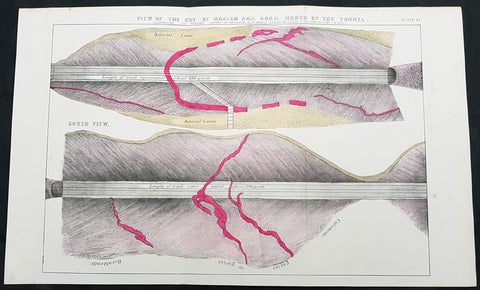
1842 William Mather Antique Geology Print Digging of New York & Harlem Railroad
- Title : View of the Cut of Harlem Rail Road North of the Tunnel
- Size: 18 1/2 in x 11in (460mm x 280mm)
- Condition: (A+) Fine Condition
- Date : 1842
- Ref #: 93062
Description:
This original antique coloured lithograph plate depicting a cross sectional geological part view of the New York and Harlem Railroad and the Park Avenue or Murray Hill Tunnel by the Endicott company, was published in the 1842 edition of William Mathers Geology of New York
The view depicts about 400 yards of rail in two views, a north view and a south view. Each view is split into approximately equal distances of 200 yards each. In the views, the cross section of the ground through which the tunnel was cut is illustrated, comprised mostly of layers of diluvial loam and gneiss. Some granite veins run through the gneiss, which are colored red.
The New York and Harlem Railroad (now the Metro-North Railroads Harlem Line) was one of the first railroads in the United States, and was the worlds first street railway. Designed by John Stephenson, it was opened in stages between 1832 and 1852 between Lower Manhattan to and beyond Harlem. Horses initially pulled railway carriages, followed by a conversion to steam engines, then one to battery-powered Julien electric traction cars. In 1907 the then leaseholders of the line, New York City Railway, a streetcar operator, went into receivership. Following a further receivership in 1932 the New York Railways Corporation converted the line to bus operation. The Murray Hill Tunnel now carries a lane of road traffic, but not the buses.
The line became part of the New York Central Railroad system with trackage rights granted to the New York, New Haven and Hartford Railroad into Manhattan. It is now part of the Metro-North Railroad system, and the only Manhattan trackage of that system.
General Definitions:
Paper thickness and quality: - Heavy and stable
Paper color : - off white
Age of map color: - Original
Colors used: - Yellow, green, blue, pink
General color appearance: - Authentic
Paper size: - 18 1/2 in x 11in (460mm x 280mm)
Plate size: - 18 1/2 in x 11in (460mm x 280mm)
Margins: - Min 1/2in (12mm)
Imperfections:
Margins: - None
Plate area: - Folds as issued
Verso: - None
Background:
In 1836 William Williams Mather was appointed geologist of the first district, or 21 counties, of New York State. This work required seven years, and his final report was a quarto of 671 pages, with forty-six colored plates, a great undertaking for the early days of geological research. From 1837 to 1840, he also superintended the geological survey of the state of Ohio, and made elaborate reports (2 vols., Columbus, 1838). In 1838/9 he made a report upon the geological reconnaissance of the state of Kentucky.
Mather, William W. 1804 - 1859
Mather was an important American geologist and natural historian. Mather was born in Brooklyn, Connecticut to an old New England family. In 1823, as a young man, he entered the West Point military academy after which he served as a 2nd Lieutenant in the Seventh Infantry. His interest in Chemistry and mineralogy soon called him back to West Point where he acted as an Assistant Professor of Geology. After resigning from the Army in 1834 with a rank of 1st Lieutenant, Mather accepted a position as Professor of Chemistry at the University of Louisiana. Later he was employed as Professor of Natural History and Sciences at the University of Ohio, was appointed Geologist of the First Geological District of New York for Governor William H. Seward, and was the State Geologist of both Ohio and Kentucky. In 1847 Mather became president of the University of Ohio. During his long career Mather made copious notes regarding his geological explorations, published profusely, and had a lively and extensive correspondence - much of which remains accessible to this day. Mather reports on one humorous incident in Long Island where, while collecting rock specimens, he had a run-in with a local farmer. The famer, observing the care with which Mather collected and cataloged his rock specimens, assumed that Mather had, in fact, discovered gold! Mather died in Columbus, Ohio on February 26, 1859. Today the W.W. Mather Medal is an important Geologic Reserach commendation. (Collections of the Minnesota Historical Society, p. 133.)
Endicott and Company (fl. c. 1828 - 1891) was a New York based family run lithography firm that flourished throughout the 19th century. The firm was founded by George and William Endicott, brothers who were born in Canton, Massachusetts. George Endicott (June 14, 1802 - 1848) trained as a lithographer under Pendleton Lithography from January of 1826. He later worked as superintendent of Senefelder Company until the summer of 1828. Afterwards, in 1830, he relocated to Baltimore and partnered with Moses Swett. Endicott and Swett relocated to New York City in December of 1831. They remained partners until July of 1834 when the relationship dissolved. George set up shop on his own account at 359 Broadway. William Endicott (1815 - 1851), George\\\'s younger brother of 14 years, joined the firm in 1840 and was made a partner in 1845, after which the name of the firm was changed to G. and W. Endicott. George Endicott died shortly afterward, in 1848, but William continued operating the firm as William Endicott and Co. until his own 1851 death at just 35 years. The firm was carried on by his widow Sara Munroe Endicott until it was taken over by her son, Francis Endicott, who ran the firm from 1852 to 1886. George Endicott, Jr. subsequently ran the firm from 1887 to 1891. Peters, in his important work on American lithography America on Stone writes \\\"it is hard to summarize the Endicotts. They did everything and did it well . . . [they] worked with and for Currier and Ives, yet in spite of all that much of their work lacks real individuality.\\\" The Endicott firm was responsible for many 19th century views and plans of New York City and state as well as plans of Sacramento, California, and the Midwest.
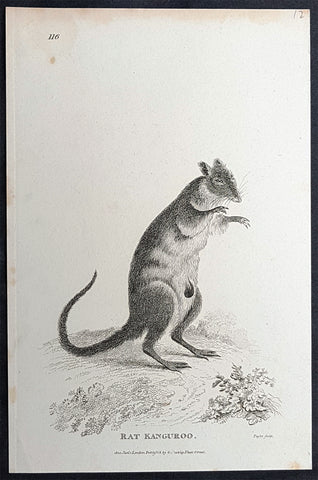
1800 George Kearsley Shaw Antique Early Print The Australian Musky Rat Kangaroo
- Title : Rat Kangaroo...1800 Jan 1 London Published by G Kearsley Fleet St.
- Date : 1800
- Condition: (A+) Fine Condition
- Ref: 33077
- Size: 8 1/2in x 5in (215mm x 125mm)
Description:
This original copper-plate engraved antique print of the Australian Musky rat-kangaroo was engraved by Isaac Taylor (1730-1807) in 1800 - dated - and published by George Kearsley Shaw in the 1803 edition of the Zoology of New Holland one of the earliest publications to name many Australian animals, for the first time.
General Definitions:
Paper thickness and quality: - Heavy and stable
Paper color : - off white
Age of map color: -
Colors used: -
General color appearance: -
Paper size: - 8 1/2in x 5in (215mm x 125mm)
Plate size: - 8 1/2in x 5in (215mm x 125mm)
Margins: - Min 1/2in (12mm)
Imperfections:
Margins: - Light age toning
Plate area: - None
Verso: - None
Background:
The musky rat-kangaroo is a marsupial species found only in the rainforests of northeast Australia. Although some scientists place this species as a subfamily (Hypsiprymnodontinae) of the family Potoroidae, the most recent classification places it in the family Hypsiprymnodontidae with prehistoric rat-kangaroos.
It is the smallest macropod that is quadrupedal and only diurnal. The musky rat-kangaroo is about 21 to 34 cm long with a 6.5- to 12.3-cm-long hairless tail, weighs between 332 and 680 g, and eats fallen fruit and large seeds, as well as small invertebrates.
It moves by extending its body and then bringing both of its hind legs forward, and uses an opposable digit on the hind foot to climb trees.
Shaw, George Kearsley 1751 - 1813
Shaw was an English botanist and zoologist. He was born at Bierton, Buckinghamshire, and was educated at Magdalen Hall, Oxford, receiving his M.A. in 1772. He took up the profession of medical practitioner. In 1786 he became the assistant lecturer in botany at Oxford University. He was a co-founder of the Linnean Society in 1788, and became a fellow of the Royal Society in 1789.
In 1791 Shaw became assistant keeper of the natural history department at the British Museum, succeeding Edward Whitaker Gray as keeper in 1806. He found that most of the items donated to the museum by Hans Sloane were in very bad condition. Medical and anatomical material was sent to the museum at the Royal College of Surgeons, but many of the stuffed animals and birds had deteriorated and had to be burnt. He was succeeded after his death by his assistant Charles Konig.
Shaw published one of the first English descriptions with scientific names of several Australian animals in his Zoology of New Holland first published in 1794. He was among the first scientists to examine a platypus and published the first scientific description of it in The Naturalists Miscellany in 1799.
In the field of herpetology he described numerous new species of reptiles and amphibians.
His other publications included:
- Musei Leveriani explicatio, anglica et Latina, containing select specimens from the museum of the late Sir Ashton Lever (1792–6), which had been moved to be displayed at the Blackfriars Rotunda.
- General Zoology, or Systematic Natural History (16 vol.) (1809–1826) (volumes IX to XVI by James Francis Stephens)
- The Naturalist\\\'s Miscellany: Or, Coloured Figures Of Natural Objects; Drawn and Described Immediately From Nature (1789–1813) with Frederick Polydore Nodder (artist and engraver).
The standard botanical author abbreviation G.Shaw is applied to species he described.
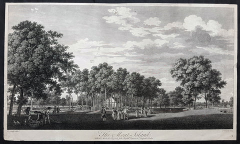
1772 John Boydell Antique Print of Moat Island Eight Views of Windsor Great Park
- Title : The Moat Island Published March the 2nd 1772 by John Boydell Engraver in Cheapside London
- Size: 23 1/2in x 13 1/2in (595mm x 340mm)
- Condition: (B) Good Condition
- Date : 1772
- Ref #: 91158-1
Description:
This large original copper-plate engraved antique print of The Moat Island in Great Windsor Park by Thomas Sandby was engraved by François Vivares and published by John Boydell for the 1772 edition of Eight Views of Windsor Great Park
Thomas Sandby RA 1721 – 1798 was an English draughtsman, watercolour artist, architect and teacher. In 1743 he was appointed private secretary to the Duke of Cumberland, who later appointed him Deputy Ranger of Windsor Great Park, where he was responsible for considerable landscaping work.
Along with his younger brother Paul, he was one of the founding members of the Royal Academy in 1768, and was its first professor of architecture. His most notable architectural work was the Freemason\'s Hall in London (now demolished).
Francois Vivares 1709 – 1780 was a French landscape-engraver, active in England.
General Definitions:
Paper thickness and quality: - Heavy and stable
Paper color : - off white
Age of map color: -
Colors used: -
General color appearance: -
Paper size: - 23 1/2in x 13 1/2in (595mm x 340mm)
Plate size: - 23 1/2in x 13 1/2in (595mm x 340mm)
Margins: - Min 1/2in (12mm)
Imperfections:
Margins: - Soiling and creasing
Plate area: - Several small tears and holes repaired
Verso: - Repairs as noted
Background:
The set of eight folio plates published in Eight Views of Windsor Great Park executed by Thomas Sandby and his brother Paul with the assistance of several noted English engravers. The 8 views were considered to be the finest set of topographical country house views after Rigauds 1739 Views of Stowe
Thomas Sandby (1721–1798) was an architect who served as draftsman to the Duke of Cumberland at the Battle of Culloden in 1746. With his younger brother Paul, a landscape painter and watercolourist, they were founding members of the Royal Academy in 1768.
Through these engravings, the Duke of Cumberland sought to commemorate his alteration of the park, which had served English royalty since the eleventh century as a hunting and jousting ground and, beginning in the eighteenth century, as a place of formal gardens and walks. (The Duke is pictured in several of the engravings, arriving by carriage, directing workers by a bridge, and discoursing with the King by the river.) The improvements to Windsor Great Park recorded in these engravings include a dam built in 1749, forming an artificial lake, rockwork, a cascade, and a grotto. In 1752, a fifty-ton ships hull was raised from the Thames and fitted up on the artificial lake as a Mandarin Yacht or Chinese Junk. A triangular Gothic belvedere was erected on Shrubs Hill to the south, and a large wooden footbridge was constructed over the water. Renovations were also undertaken at the so-called Great Lodge, which became the Dukes residence at Windsor. In short, these improvements partook of the fashionable taste for picturesque Gothick – that was most noticeably championed by Horace Walpoles contemporary Strawberry Hill villa.
Much of these improvements, which were actually the work of architect Henry Flitcroft, were destroyed by severe floods, which broke the dam at Virginia Water in 1768 and again in 1782. These views therefore provide evidence for the state of the park at that date.
Original sketches and preparatory drawings by Paul and Thomas Sandby related to these engravings survive in the Royal Collection at Windsor Castle, the Victoria and Albert Museum, and the British Museum.
Boydell, John 1720 - 1804
Boydell 1804 was an 18th-century British publisher noted for his reproductions of engravings. He helped alter the trade imbalance between Britain and France in engravings and initiated a British tradition in the art form. A former engraver himself, Boydell promoted the interests of artists as well as patrons and as a result his business prospered.
The son of a land surveyor, Boydell apprenticed himself to William Henry Toms, an artist he admired, and learned engraving. He established his own business in 1746 and published his first book of engravings around the same time. Boydell did not think much of his own artistic efforts and eventually started buying the works of others, becoming a print dealer as well as an artist. He became a successful importer of French prints during the 1750s but was frustrated by their refusal to trade prints in kind. To spark reciprocal trade, he commissioned William Wolletts spectacular engraving of Richard Wilsons The Destruction of the Children of Niobe, which revolutionised the print trade. Ten years later, largely as a result of Boydells initiative, the trade imbalance had shifted, and he was named a fellow of the Royal Society for his efforts.
In the 1790s, Boydell began a large Shakespeare venture that included the establishment of a Shakespeare Gallery, the publication of an illustrated edition of Shakespeares plays, and the release of a folio of prints depicting scenes from Shakespeares works. Some of the most illustrious painters of the day contributed, such as Benjamin West and Henry Fuseli.
Throughout his life, Boydell dedicated time to civic projects: he donated art to government institutions and ran for public office. In 1790 he became Lord Mayor of London. The French Revolutionary Wars led to a cessation in Continental trade at the end of the 1790s. Without this business, Boydells firm declined and he was almost bankrupt at his death in 1804.
In 1751, with his large volume of prints, Boydell moved to larger premises at 90 Cheapside. By 1755, he had published A Collection of One Hundred and Two Views, &C. in England and Wales. This cheap but successful book gave him capital to invest. He became increasingly immersed in the commercial side of the print business and like most print dealers began importing prints to sell. These included print reproductions of landscapes by artists such as Claude Lorrain and Salvator Rosa. The bulk of the imports came from the undisputed masters of engraving during the 18th century: the French. Boydell made a small fortune in the 1750s from these imported prints. His early success was acknowledged in 1760 when he was named a member of the Royal Society.Winifred Friedman, who has written extensively on Boydell, explains that despite this success, [w]hat rankled Boydell was that the French would not extend credit, or exchange prints; he was required to produce hard cash. Boydell took action, and this was the turning point.
In 1761, Boydell decided that he would attempt to trade with the French in kind—something they had refused in the past because of the poor quality of British engravings. To inaugurate this change, he had to have a truly spectacular print. To this end, he hired William Woollett, the foremost engraver in England, to engrave Richard Wilsons Destruction of the Children of Niobe. Woollett had already successfully engraved Claude Lorrains 1663 painting The Father of Psyche Sacrificing at the Temple of Apollo for Boydell in 1760. Boydell paid him approximately £100 for the Niobe engraving, a staggering amount compared to the usual rates. This single act of patronage raised engravers fees throughout London. The print was wildly successful, but more importantly, the French accepted it as payment in kind. In fact, it was the first British print actively desired on the Continent. By 1770, the British were exporting far more prints than they were importing, largely due to Boydell.
Boydells business flourished and he soon hired his nephew, Josiah Boydell, to assist him. Boydells biographer, Sven Bruntjen, hypothesizes that one of the reasons for Boydells early and phenomenal success was his specialisation. Unlike his competitors [who sold manuals, atlases and other assorted books] ... his [business had an] almost exclusive concentration on the sale of reproductive prints. Bruntjen argues that despite the extensive sales of varied types of reproductive prints, it was the contemporary history print which accounted for the major part of Boydells success as a print dealer. Most notable among these was the Death of General Wolfe a 1770 painting by Benjamin West, engraved by Woollett for Boydell in 1776. As early as 1767, Boydell had stopped engraving prints himself and began exclusively relying on commissions and trades and it was from these that he profited.
Boydell had opened up a new market with Niobe and he quickly followed up this success. With a prospering business and capital in reserve, he embarked on several ambitious projects, often simultaneously. In 1769, he began A Collection of Prints, Engraved after the Most Capital Paintings in England. Its last, and ninth volume, was finished in 1792 to great critical and financial success. In 1773, he began A Set of Prints Engraved after the Most Capital Paintings in the Collection of Her Imperial Majesty the Empress of Russia, Lately in the Possession of the Earl of Orford at Houghton in Norfolk, which was finished in 1788.
In addition to these projects and in the middle of his Shakespeare undertaking Boydell experimented with aquatint in An History of the River Thames, published in 1796. Bruntjen writes, although not the first colored aquatint book, [it] was the first major one, and it was to set an example for the type of illustration that was to enjoy widespread popularity in England for some forty years. Boydell also published The Original Work of William Hogarth in 1790 and The Poetical Works of John Milton and The Life of the Poet (i.e., Milton) in 1794.
The productivity and profitability of Boydells firm spurred the British print industry in general. By 1785, annual exports of British prints reached £200,000 while imports fell to £100. Boydell was acknowledged and praised throughout England as the agent of this stunning economic reversal. In 1773 he was awarded the Royal Academy Gold Medal for his services in advancing the print trade. In 1789, at the Royal Academy dinner, the Prince of Wales toasted an English tradesman who patronizes art better than the Grand Monarque, Alderman Boydell, the Commercial Maecenas
1836 Dumont D Urville Large Antique Print Monument to La Perouse Solomon Islands
- Title : Inauguration du Monument
- Size: 19 1/2in x 13 1/2in (495mm x 345mm)
- Condition: (B) Good Condition
- Date : 1836
- Ref #: 31734-1
Description:
This large original antique lithograph print of Dumont D Urville Inauguration of a monument to Jean François de Galaup, comte de Lapérouse on the island of Vanikoro, part of the Solomon Islands in the south Pacific (the last resting place of La Perouse & his crew), by Louis Auguste de Sainson, the artist on the Astrolabe, during the first of Dumont D Urvilles first voyage to the South Seas between 1826 - 1829, was engraved by Antoine Maurin 1793 - 1860 and published in the 1836 1st edition of Dumont d Urvilles Voyage de la corvette L Astrolabe: exécuté par ordre du roi, pendant les années 1826-1827-1828-1829......
Louis Auguste de Sainson, (1800-1848). Sainson was a French draftsman & artist who specialized in natural history and geography. He accompanied the expedition of the corvette L Astrolabe as a naturalist directed by Jules Dumont d\\\'Urville between 1826-1829.
He began his naval career in a secretarial position at the French Atlantic port of Rochefort, working there from 1825 till 1826. He then volunteered to join the Astrolabe as a draughtsman, after being recommended to the expedition by Quoy, one of the naturalists on the expedition, joining the ship at Toulon on 7 February 1826.
He was responsible for the bulk of the drawings produced during the expedition, with over 500 in three years. Many of his drawings paintings and prints now reside in Australian, New Zealand & French museums.
General Definitions:
Paper thickness and quality: - Heavy and stable
Paper color : - off white
Age of map color: -
Colors used: -
General color appearance: -
Paper size: - 19 1/2in x 13 1/2in (495mm x 345mm)
Plate size: - 19 1/2in x 13 1/2in (495mm x 345mm)
Margins: - Min 1/2in (12mm)
Imperfections:
Margins: - Re-join to bottom margin
Plate area: - 9in & 2in re-join to bottom to centre of image
Verso: - Repair as noted, light spotting
Background:
Jean François de Galaup, comte de Lapérouse (1741 – 1788) was a French Naval officer and explorer whose expedition vanished in Oceania.
Lapérouse was appointed in 1785 by Louis XVI and by the Secretary of State of the Navy, the Marquis de Castries, to lead an expedition around the world. Many countries were initiating voyages of scientific explorations at that time.
The expeditions aims were to complete the Pacific discoveries of James Cook (whom Lapérouse greatly admired), correct and complete maps of the area, establish trade contacts, open new maritime routes and enrich French science and scientific collections. His ships were LAstrolabe (under Fleuriot de Langle) and La Boussole, both 500 tons. They were storeships reclassified as frigates for the occasion. Their objectives were geographic, scientific, ethnological, economic (looking for opportunities for whaling or fur trading), and political (the eventual establishment of French bases or colonial cooperation with their Spanish allies in the Philippines). They were to explore both the north and south Pacific, including the coasts of the Far East and of Australia, and send back reports through existing European outposts in the Pacific.
La Perouse visited Australia, arriving off Botany Bay on 24 January 1788. There Lapérouse encountered a British convoy (known later as the First Fleet) led by Captain Arthur Phillip RN, who was to establish the penal colony of New South Wales. While it had been intended that the colony would be located at Botany Bay, Phillip had quickly decided that the site was unsuitable and the colony would instead be established at Sydney Cove in Port Jackson. High winds – which had hindered Lapérouses ships in entering Botany Bay – delayed the relocation until 26 January (later commemorated as Australia Day).
The French were received courteously and spent six weeks at the British colony (their last recorded landfall). While Lapérouse and Phillip did not meet, French and British officers visited each other formally on at least 11 occasions, and offered each other assistance and supplies. During their stay, the French established an observatory and a garden, held masses, and made geological observations. Lapérouse also took the opportunity to send journals, charts and letters back to Europe, with the British merchant ship Alexander. The chaplain from L Astrolabe, Father Louis Receveur, never recovered from injuries he had sustained in a clash with indigenous people in the Samoan Islands and died at Botany Bay on 17 February; Receveur was buried on shore at Frenchmans Cove.
On 10 March, after taking on sufficient wood and fresh water, the French expedition left New South Wales – bound for New Caledonia, Santa Cruz, the Solomons, the Louisiades, and the western and southern coasts of Australia. While Lapérouse had reported in a letter from Port Jackson that he expected to be back in France by June 1789, neither he nor any members of his expedition were seen again by Europeans.
1719 Chatelain Large Antique Map of Barbary Coast, North Africa Morocco to Libya
- Title : Description Du Nil. Des Sources de son Cours Depuis Les Catactes....
- Size: 20in x 17 1/2in (510mm x 440mm)
- Condition: (A+) Fine Condition
- Date : 1719
- Ref #: 50651
Description:
This large original copper-plate engraved antique print of views of the Pyramids, ruins and the Nile River, speculating on the source (not known until the mid 19th century) was published by Henri Abraham Chatelain in 1719, in his famous Atlas Historique.
General Definitions:
Paper thickness and quality: - Heavy and stable
Paper color : - off white
Age of map color: -
Colors used: -
General color appearance: -
Paper size: - 20in x 17 1/2in (510mm x 440mm)
Plate size: - 17 1/2in x 15in (440mm x 380mm)
Margins: - Min 1in (25mm)
Imperfections:
Margins: - None
Plate area: - None
Verso: - None
Background:
The river Nile has two major tributaries, the White Nile and Blue Nile. The White Nile is considered to be the headwaters and primary stream of the Nile itself. The Blue Nile, however, is the source of most of the water and silt. The White Nile is longer and rises in the Great Lakes region of central Africa, with the most distant source still undetermined but located in either Rwanda or Burundi. It flows north through Tanzania, Lake Victoria, Uganda and South Sudan. The Blue Nile begins at Lake Tana in Ethiopia and flows into Sudan from the southeast. The two rivers meet just north of the Sudanese capital of Khartoum.
Europeans began to learn about the origins of the Nile in the 14th century when the Pope sent monks as emissaries to Mongolia who passed India, the middle east and Africa, and described being told of the source of the Nile in Abyssinia (ancient European name for Ethiopia) Later in the 15th and 16th centuries, travelers to Ethiopia visited Lake Tana and the source of the Blue Nile in the mountains south of the lake. Although James Bruce claimed to be the first European to have visited the headwaters, modern writers give the credit to the Jesuit Pedro Páez. Páezs account of the source of the Nile is a long and vivid account of Ethiopia. It was published in full only in the early 20th century, although it was featured in works of Páezs contemporaries, including Baltazar Téllez, Athanasius Kircher and by Johann Michael Vansleb.
Europeans had been resident in Ethiopia since the late 15th century, and one of them may have visited the headwaters even earlier without leaving a written trace. The Portuguese João Bermudes published the first description of the Tis Issat Falls in his 1565 memoirs, compared them to the Nile Falls alluded to in Ciceros De Republica. Jerónimo Lobo describes the source of the Blue Nile, visiting shortly after Pedro Páez. Telles also used his account.
The White Nile was even less understood. The ancients mistakenly believed that the Niger River represented the upper reaches of the White Nile. For example, Pliny the Elder wrote that the Nile had its origins in a mountain of lower Mauretania, flowed above ground for many days distance, then went underground, reappeared as a large lake in the territories of the Masaesyli, then sank again below the desert to flow underground for a distance of 20 days journey till it reaches the nearest Ethiopians. A merchant named Diogenes reported that the Niles water attracted game such as buffalo.
Lake Victoria was first sighted by Europeans in 1858 when the British explorer John Hanning Speke reached its southern shore while traveling with Richard Francis Burton to explore central Africa and locate the great lakes. Believing he had found the source of the Nile on seeing this vast expanse of open water for the first time, Speke named the lake after the then Queen of the United Kingdom. Burton, recovering from illness and resting further south on the shores of Lake Tanganyika, was outraged that Speke claimed to have proved his discovery to be the true source of the Nile when Burton regarded this as still unsettled. A very public quarrel ensued, which sparked a great deal of intense debate within the scientific community and interest by other explorers keen to either confirm or refute Spekes discovery. British explorer and missionary David Livingstone pushed too far west and entered the Congo River system instead. It was ultimately Welsh-American explorer Henry Morton Stanley who confirmed Spekes discovery, circumnavigating Lake Victoria and reporting the great outflow at Ripon Falls on the Lakes northern shore.
European involvement in Egypt goes back to the time of Napoleon. Laird Shipyard of Liverpool sent an iron steamer to the Nile in the 1830s. With the completion of the Suez Canal and the British takeover of Egypt in the 1870s, more British river steamers followed.
The Nile is the areas natural navigation channel, giving access to Khartoum and Sudan by steamer. The Siege of Khartoum was broken with purpose-built sternwheelers shipped from England and steamed up the river to retake the city. After this came regular steam navigation of the river. With British Forces in Egypt in the First World War and the inter-war years, river steamers provided both security and sightseeing to the Pyramids and Thebes. Steam navigation remained integral to the two countries as late as 1962. Sudan steamer traffic was a lifeline as few railways or roads were built in that country. Most paddle steamers have been retired to shorefront service, but modern diesel tourist boats remain on the river.
1719 Chatelain Large Antique Print of Egypt Pyramids, & Source of the Nile River
- Title : Description Du Nil. Des Sources de son Cours Depuis Les Catactes....
- Size: 20in x 17 1/2in (510mm x 440mm)
- Condition: (A+) Fine Condition
- Date : 1719
- Ref #: 50651
Description:
This large original copper-plate engraved antique print of views of the Pyramids, ruins and the Nile River, speculating on the source (not known until the mid 19th century) was published by Henri Abraham Chatelain in 1719, in his famous Atlas Historique.
General Definitions:
Paper thickness and quality: - Heavy and stable
Paper color : - off white
Age of map color: -
Colors used: -
General color appearance: -
Paper size: - 20in x 17 1/2in (510mm x 440mm)
Plate size: - 17 1/2in x 15in (440mm x 380mm)
Margins: - Min 1in (25mm)
Imperfections:
Margins: - None
Plate area: - None
Verso: - None
Background:
The river Nile has two major tributaries, the White Nile and Blue Nile. The White Nile is considered to be the headwaters and primary stream of the Nile itself. The Blue Nile, however, is the source of most of the water and silt. The White Nile is longer and rises in the Great Lakes region of central Africa, with the most distant source still undetermined but located in either Rwanda or Burundi. It flows north through Tanzania, Lake Victoria, Uganda and South Sudan. The Blue Nile begins at Lake Tana in Ethiopia and flows into Sudan from the southeast. The two rivers meet just north of the Sudanese capital of Khartoum.
Europeans began to learn about the origins of the Nile in the 14th century when the Pope sent monks as emissaries to Mongolia who passed India, the middle east and Africa, and described being told of the source of the Nile in Abyssinia (ancient European name for Ethiopia) Later in the 15th and 16th centuries, travelers to Ethiopia visited Lake Tana and the source of the Blue Nile in the mountains south of the lake. Although James Bruce claimed to be the first European to have visited the headwaters, modern writers give the credit to the Jesuit Pedro Páez. Páezs account of the source of the Nile is a long and vivid account of Ethiopia. It was published in full only in the early 20th century, although it was featured in works of Páezs contemporaries, including Baltazar Téllez, Athanasius Kircher and by Johann Michael Vansleb.
Europeans had been resident in Ethiopia since the late 15th century, and one of them may have visited the headwaters even earlier without leaving a written trace. The Portuguese João Bermudes published the first description of the Tis Issat Falls in his 1565 memoirs, compared them to the Nile Falls alluded to in Ciceros De Republica. Jerónimo Lobo describes the source of the Blue Nile, visiting shortly after Pedro Páez. Telles also used his account.
The White Nile was even less understood. The ancients mistakenly believed that the Niger River represented the upper reaches of the White Nile. For example, Pliny the Elder wrote that the Nile had its origins in a mountain of lower Mauretania, flowed above ground for many days distance, then went underground, reappeared as a large lake in the territories of the Masaesyli, then sank again below the desert to flow underground for a distance of 20 days journey till it reaches the nearest Ethiopians. A merchant named Diogenes reported that the Niles water attracted game such as buffalo.
Lake Victoria was first sighted by Europeans in 1858 when the British explorer John Hanning Speke reached its southern shore while traveling with Richard Francis Burton to explore central Africa and locate the great lakes. Believing he had found the source of the Nile on seeing this vast expanse of open water for the first time, Speke named the lake after the then Queen of the United Kingdom. Burton, recovering from illness and resting further south on the shores of Lake Tanganyika, was outraged that Speke claimed to have proved his discovery to be the true source of the Nile when Burton regarded this as still unsettled. A very public quarrel ensued, which sparked a great deal of intense debate within the scientific community and interest by other explorers keen to either confirm or refute Spekes discovery. British explorer and missionary David Livingstone pushed too far west and entered the Congo River system instead. It was ultimately Welsh-American explorer Henry Morton Stanley who confirmed Spekes discovery, circumnavigating Lake Victoria and reporting the great outflow at Ripon Falls on the Lakes northern shore.
European involvement in Egypt goes back to the time of Napoleon. Laird Shipyard of Liverpool sent an iron steamer to the Nile in the 1830s. With the completion of the Suez Canal and the British takeover of Egypt in the 1870s, more British river steamers followed.
The Nile is the areas natural navigation channel, giving access to Khartoum and Sudan by steamer. The Siege of Khartoum was broken with purpose-built sternwheelers shipped from England and steamed up the river to retake the city. After this came regular steam navigation of the river. With British Forces in Egypt in the First World War and the inter-war years, river steamers provided both security and sightseeing to the Pyramids and Thebes. Steam navigation remained integral to the two countries as late as 1962. Sudan steamer traffic was a lifeline as few railways or roads were built in that country. Most paddle steamers have been retired to shorefront service, but modern diesel tourist boats remain on the river.
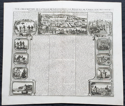
1719 Chatelain Large Antique Print Views of Loango & Mbanza Loango, Congo Africa
- Title : Vue & Description de la Ville De Lovango dans la Royaume de Congo avec plu Sieurs....
- Size: 20in x 17 1/2in (510mm x 440mm)
- Condition: (A+) Fine Condition
- Date : 1719
- Ref #: 50641-1
Description:
This large original copper-plate engraved antique print city of Mbanza Loango in the pre-colonial African Kingdom of Loango - now part of the of western part of the Republic of the Congo - with 10 vignettes of various peoples & views of Kingdom of Loango, Africa was published by Henri Abraham Chatelain in 1719, in his famous Atlas Historique.
General Definitions:
Paper thickness and quality: - Heavy and stable
Paper color : - off white
Age of map color: -
Colors used: -
General color appearance: -
Paper size: - 20in x 17 1/2in (510mm x 440mm)
Plate size: - 17 1/2in x 15in (440mm x 380mm)
Margins: - Min 1in (25mm)
Imperfections:
Margins: - None
Plate area: - None
Verso: - None
Background:
The Kingdom of Loango was a pre-colonial African state, during approximately the 16th to 19th centuries in what is now the western part of the Republic of the Congo. Situated to the north of the more powerful Kingdom of Kongo, at its height in the 17th century Loango influence extended from Cape St Catherine in the north to almost the mouth of the Congo River.
Loango exported copper to the European market, and was a major producer and exporter of cloth.
The English traveller Andrew Battel, when he was there in about 1610, recorded that the predecessor of the unnamed king ruling at that time was named \\\"Gembe\\\" or Gymbe (modernized as Njimbe), possibly the founder of the kingdom. With the death of King Buatu in 1787, the succession of leadership is uncertain.
The kingdom is certain to have come to an end with the Conference of Berlin (1884–1885) at the latest, when European colonial powers divided most of Central Africa between them.
The origins of the kingdom are obscure. The most ancient complex society in the region was at Madingo Kayes, which was already a multi-site settlement in the first century CE. At present archaeological evidence is too scarce to say much more about developments until the late fifteenth or early sixteenth centuries.
Loango is not mentioned in early travelers\\\' accounts of the region, nor is it mentioned in the titles of King Afonso I of Kongo in 1535, though Kakongo, Vungu, and Ngoyo, its southern neighbors. It is therefore unlikely that there was a major power on the coast of Central Africa north of the Congo River.
The earliest reference to Loango in a documentary source is a mention around 1561 by Sebastião de Souto, a priest in Kongo, that King Diogo I (1545–61) sent missionaries to convert Loango to Christianity. Duarte Lopes, ambassador from Kongo to the Holy See in Rome in 1585, related that \\\"Loango is a friend of the King of Congo and it is said that he was a vassal in past times\\\" which is consistent with Loango\\\'s origins from Kakongo, a vassal of Kongo.
Dutch visitors recorded the first traditional account of the kingdom\\\'s origin in the 1630s or \\\'40s. In their account as reported by the geographer Olfert Dapper, the region where Loango would be constructed was populated by a number of small polities including Mayumba, Kilongo, Piri and Wansi, \\\"each with their own leader\\\" who \\\"made war on each other.\\\" He recorded that the founder of Loango, who boasted hailing from the district in Nzari in the small coastal kingdom of Kakongo, itself a vassal of Kongo, triumphed over all his rivals through the skillful use of alliances to defeat those who opposed him, particularly Wansa, Kilongo and Piri, the latter two of which required two wars to subdue. Once this had been effected, however, a range of more northern regions, including Docke and Sette submitted voluntarily. Having succeeded in the conquest, the new king moved northward and after having founded settlements in a variety of places, eventually built his capital in Buali in the province of Piri (from which the ethnic name \\\"Muvili\\\" eventually derived).
The English traveller Andrew Battel wrote when he was there in about 1610, that the predecessor of the unnamed king ruling at that time was named \\\"Gembe\\\" or \\\"Gymbe\\\" (modernized as \\\"Njimbe\\\"). A Dutch description published in 1625 said that a ruler who had died sometime before that date had ruled for 60 years and thus had taken the throne around 1565. The documentary chronology thus makes it very likely that Njimbe was the founder and first ruler mentioned in the traditions, and this supposition is supported by traditions recorded around 1890 by R. E. Dennett which also named Njimbe as the first ruler.
On the basis of later traditions from the nineteenth and twentieth centuries that linked the founding of Loango to that of Kongo, Phyllis Martin posited a much earlier foundation, the late fourteenth or early fifteenth centuries. She then argues that the absence of Loango from early titles of the king of Kongo is evidence that Loango was already independent at that time.
Njimbe had created a rule of succession which was in place around 1600, in which the king gave command over four provinces to members of his family, called the provinces of Kaye, Boke, Selage, and Kabango, and the king was to be chosen from a rotation between them. When the king died the ruler of Kaye took over, as he did indeed in the pre-1624 succession, and if the rule was followed then the ruler of Boke took his place; the other two provincial rulers advanced as well, and the king appointed a new ruler for Kabango.
In 1663, the king ruling then was baptized as Afonso by the Italian Capuchin priest Bernardo Ungaro, but there was considerable opposition to this from within the country, and indeed when he died, a non-Christian took over, but this one was himself overthrown by one of the Christian party in 1665. This civil war was still ongoing in the 1670s. In the aftermath of this civil war, a number of the Christian party fled to neighboring territories, one of whom, known to history as Miguel da Silva, was elected ruler of Ngoyo and was ruling there in 1682.
When Nathaniel Uring, an English merchant came to Loango to trade in 1701, he reported that the king had died and the power of the administration was in the hands of the \\\"Queen or Chief Governess of that Country,\\\" named \\\"Mucundy\\\" and with whom he had to deal as if with the ruler.[20] This title referred to a woman with a regular role in the administration as overseer of women\\\'s affairs.
Many years elapsed before we have another snapshot of Loango\\\'s government; during this time the rules of succession, whether formal or informal seem to have changed. When the French missionaries directed by Abbé Liévin-Bonaventure Proyart came to Loango in 1766, they noted that there was no clear succession to the throne, that anyone born of a person regarded as a princess (only female succession mattered) could aspire to the throne. Moreover, the death of a king was cause for a frequently long interregnum; the king ruling in 1766 had come to power only after an interregnum of seven years, during which time the affairs of the country were managed by a regent called Mani Boman. The Mani Boman was appointed by the king during his lifetime. Usually two were appointed to cover the eventuality of the death of one of the two. They, in turn received the petitions of a number of eligible candidates for the throne.
Eventually, the electors of the kingdom, who were those who held offices appointed by the late king, met to decide on the next king. In theory, as the old constitution maintained, the king named his successor as well and placed him as ruler of Kaye, to succeed him at his death, but as there was so much contention as to who should hold the position, the late king died without naming a Ma-Kaye.
Historian Phyllis Martin contends that the external trade of the country had enriched some members of the nobility ahead of others and had thus put pressure on the older constitution as wealthier upstart princes pressed their case forward. She argues that important members of the council were people who had obtained their positions through contact with external trade, particularly the slave trade, and they had come to share power with the king. She posits that this alteration in relative power allowed the council to dominate the king by forcing longer and longer interregna. In fact, after the death of King Buatu in 1787, no king was elected for over 100 years.However, to some extent royal authority remained in the hands of a person entitled the Nganga Mvumbi (priest of the corpse) who oversaw the body of the dead king awaiting burial. Several of these Nganga Mvumbi succeeded each other in the late eighteenth and through the nineteenth centuries.
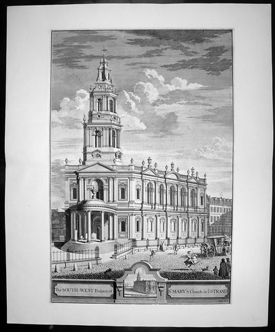
1724 Johannes Kip Large Antique Print of St Marys Church, The Strand, London
- Title : The South West Prospect of St Mary's Church in ye Strand
- Date : 1724
- Condition: (A+) Fine Condition
- Ref: 40400
- Size: 26 1/2in x 22in (670mm x 560mm)
Description: This large original copper-plate engraved antique print by Johannes (Jan) Kip, after Leonard Knyff, was published in the 1724 Joseph Smith edition of Britannia Illustrata or Nouveau Theatre de la Grande Bretagne. This beautifully engraved original antique print is testimony to the fine, detailed work produced by Jan Kip.
Britannia Illustrata was first issued in 1707 by David Mortier as a single volume containing 80 topographical etchings by Johannes Kip, after drawings by Leonard Knyff. Many are birds eye views of country seats, but there are also a number of interesting London views. The series was first reissued and expanded into two volumes in 1708-1713, and provided with a second French title Nouveau Theatre de la Grande Bretagne.
An expanded edition of Britannia Illustrata was re-published by Joseph Smith in 1724 under its French title, Nouveau Theatre..., containing many of the plates from the original edition by Mortier and also containing may new plates of places, churches, cathedrals and architecture of the landed gentry.
Background:
The parish of St Mary le Strand may lay a good claim to being one of the oldest parishes in London. It stands dominating a roadway which since prehistory has been the main artery to the west from the City of London. In early Saxon times the Strand area was the very heart of London, for it seems that the City was effectively abandoned by the newly-arrived settlers. The Saxons predominantly inhabited "Lundenwic", an area stretching from Fleet Street to Whitehall and from the Thames to Covent Garden from the sixth to the ninth centuries. Christianity came to this settlement with St Mellitus and his followers in 604, and, despite their brief expulsion in the 620s, became firmly established. We do not know if any of the existing churches in the area date back that far but some, such as St Clement Danes, are known to have existed in later Saxon times.
There is no record of when St Mary le Strand was founded, but the first church, which was dedicated to the Nativity of the Blessed Virgin Mary, stood just south of the present church on a site now covered by Somerset House. Throughout the Middle Ages, the Bishops of Worcester were the Patrons of the parish and had their London residence on an adjoining site. For throughout the period from the Norman Conquest to the Reformation, the Strand was mainly the home of bishops and princes. Within the parish were the "inns" - large town houses with chapels, stables and accommodation for a large retinue - of the Bishops of Worcester, Llandaff, Coventry and Lichfield. A large part of the parish was absorbed by the building of a great house, the Palace of the Savoy, by Count Peter of Savoy, the uncle of Henry III, in the 1240s. A century later this became the home of John of Gaunt, Earl of Lancaster, and the palace became a centre of culture; among its residents was Geoffrey Chaucer, who was married in the palace chapel. Gaunt's unpopularity, as the king's chief minister, caused the palace to be burned in the Peasant's Revolt. Despite its long absence, the fame of the palace has lasted in the area and was recreated in the nineteenth century by the Savoy Hotel and Theatre.
The site where the present church stands was occupied in medieval times by Strand Cross. The origins of this are unclear. It was not a cross erected in memory of Queen Eleanor - as was Charing Cross - but seems to have dated back at least to Norman times. Perhaps it began as a market cross; by the early fourteenth century it had been rebuilt in a lavish manner, almost certainly following the design of the Eleanor Crosses. Strand Cross was a famous site and it is recorded that in the thirteenth century the local magistrates held their assizes in front of it.
Until the sixteenth century, the Strand was no more than a line of Bishops' palaces on the south side of the roadway stretching all the way to Whitehall. On the north side stood a wall which bounded the Convent - later Covent - Garden, while the churches further away, St Martin's and St Giles, stood "in-the-fields". All this was to change with the Reformation. The bishops' inns around the church were seized by Edward Lord Protector who set about building himself a renaissance palace in what was then the most fashionable part of town. Even with the extensive site that he had now obtained, further space was needed and towards the end of 1548 the Lord Protector's workmen fell upon St Mary's church and demolished it to provide stone for the new palace. Further stone was provided by the demolition of a cloister at St Paul's Cathedral known as Pardon Churchyard and the greater part of the Priory of St John at Clerkenwell. Even by the standards of the time, the demolition of so much sacred property was an outrage. Somerset was never to enjoy living in his new palace; just as it was nearing completion he was overthrown by his political enemies and executed at Tower Hill in 1551.
It is said that Somerset had intended to build a new parish church. If so, all thought of it passed away with his fall. Initially, the parishioners scattered but within a short time we find them gathered in the chapel of St John the Baptist in the Savoy. Here they would remain for the next 175 years. Now known at "St Mary le Savoy", the parishioners chose and paid for their own ministers. The most famous of these was Thomas Fuller, the church historian, who was appointed in 1642, fled during the Civil War and was restored to his living in 1660.
Following the execution of Somerset, his palace had passed to the possession of the Crown. Elizabeth I occasionally lodged there and it was from Somerset House that she set off to give thanks after the defeat of the Armada. Under the Stuarts, extensive improvements were made to the palace, the most impressive being the lavish Roman Catholic chapel built by Charles I's queen, Henrietta Maria.
The roadway in front of Somerset House, where Strand Cross had stood and where the present church was later to stand, was occupied in the early seventeenth century by a windmill used to pump water. In 1634 the first Hackney Carriage stand in England was established here by one Captain Bailey. Here also a maypole was erected which became the most famous maypole in London. Demolished by the Puritans, a new maypole was erected in 1661. Parts of this maypole remained until 1717, when they were removed and presented to Sir Isaac Newton as the base for a telescope.
In 1711, an Act of Parliament was passed for building 50 New Churches in the fast expanding suburbs of London. These were the so-called "Queen Ann Churches"; among them are Hawksmoor's Christ Church Spitalfields, St Anne's Limehouse, and St George's-in-the-East, Archer's St Paul's Depftord and James' St George's, Hanover Square. St Mary le Strand was quick to apply for a church to replace their demolished one and, as the site on the Strand was so prominent, the Commissioners for building the New Churches decided to make the Strand church the most lavish of the churches. Initially, it was intended that there should not be a spire but that a column celebrating the building of the New Churches should stand directly in front of the church.
General Description:
Paper thickness and quality: - Heavy and stable
Paper colour: - off white
Age of map colour: -
Colours used: -
General colour appearance: -
Paper size: - 26 1/2in x 22in (670mm x 560mm)
Plate size: - 23in x 18in (585mm x 460mm)
Margins: - min 1in (25mm)
Imperfections:
Margins: - None
Plate area: - None
Verso: - None
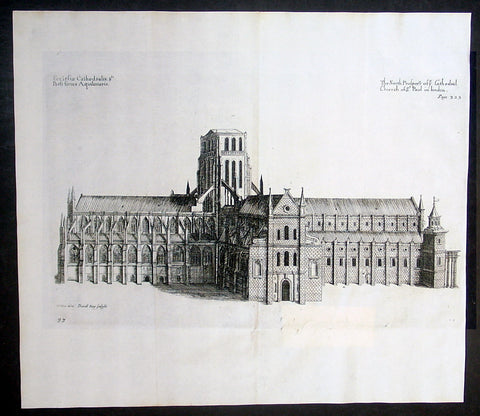
1683 Daniel King & William Dugdale Antique Print of Old St Pauls Cathedral London - Pre Great Fire
- Title : Ecclesiae Cathedralis Sti Pauli facies Aquilonaris / The North Prospect of ye Cathedral Church of St Paul in London
- Date : 1683
- Condition: (A+) Fine Condition
- Ref # : 16365
- Size : 15 1/2in x 13 1/2in (395mm x 340mm)
Description:
This fine original copper-pate antique print of the old St Pauls Cathedral London, was engraved by Daniel King prior to the Great Fire of London in 1666 and was published by Sir William Dugdale in the 1683 edition of Monasticon Anglicanum: A History of the Abbies and other Monasteries, Hospitals, Frieries, and Cathedral and Collegiate Churches, with their Dependencies, in England and Wales.
General Definitions:
Paper thickness and quality: - Heavy and stable
Paper color : - off white
Age of map color: -
Colors used: -
General color appearance: -
Paper size: - 15 1/2in x 13 1/2in (395mm x 340mm)
Plate size: - 14 1/2in x 9in (370mm x 230mm)
Margins: - Min 1/2in (12mm)
Imperfections:
Margins: - None
Plate area: - Folds as issued, small repair to bottom of page not affecting the image
Verso: - None
Background: Old St Paul's Cathedral was the medieval cathedral of the City of London that, until 1666, stood on the site of the present St Paul's Cathedral. Built in 1087–1314 and dedicated to Saint Paul, the cathedral was the fourth church on the site at Ludgate Hill. Work began during the reign of William the Conqueror after a fire in 1087 that destroyed much of the city. Work took more than 200 years, and construction was delayed by another fire in 1135. The church was consecrated in 1240 and enlarged again in 1256 and the early 14th century. At its completion in the middle of the 14th century, the cathedral was one of the longest churches in the world and had one of the tallest spires and some of the finest stained glass.
The presence of the shrine of Saint Erkenwald made the cathedral a pilgrimage site during the Medieval period. In addition to serving as the seat of the Diocese of London, the building developed a reputation as a hub of the City of London, with the nave aisle, "Paul's walk", known as a centre for business and the London grapevine. After the Reformation, the open-air pulpit in the churchyard, St Paul's Cross, became the stage for radical evangelical preaching and Protestant bookselling.
The cathedral was already severely in decline by the 17th century. Restoration work by Inigo Jones in the 1620s was halted by the English Civil War. Sir Christopher Wren was attempting another restoration in 1666 when the cathedral was destroyed in the Great Fire of London. After demolition of the old structure, the present, domed cathedral was erected on the site, with an English Baroque design by Wren
Sir William Dugdale 1605-1686 was an English antiquary and herald. As a scholar he was influential in the development of medieval history as an academic subject.
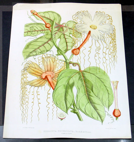
1855 Joseph Hooker & Water Fitch Large Antique Botanical Print of Lard Fruit of SE Asia - Hodgsonia
- Title: Hodgsonia Heteroclita, Hook. fil. et Thoms
- Date: 1855
- Ref: 80768
- Size: 20in x 15in (510mm x 380mm)
- Condition: A+ Fine
Description:
This beautifully hand coloured original 1855 antique lithograph print of the Hodgsonia or Lard Fruit plant - that grows from northern India to SE Asia & Indonesia, is one of a series of illustrations made for J. F. Cathcart of the Bengal Civil Service by Sir Joseph Dalton Hooker for the 1855 publication of Illustrations of Himalayan plants.
This publication contained 24 coloured plates all superbly engraved and hand coloured. The plates were executed by W. H. Fitch, analysed by the famous botanist J. D. Hooker.
General Description:
Paper thickness and quality: - Heavy & stable
Paper color: - White
Age of map color: - Early
Colors used: - Red, pink, green, brown
General color appearance: - Authentic
Paper size: - 20in x 15in (510mm x 380mm)
Margins: - Min 1/2in (12mm)
Imperfections:
Margins: - Discolouration to the top left & right margins
Plate area: - None
Verso: - None
Hodgsonia or Lard Fruit - Although the flesh of Hodgsonia fruit is inedible and considered worthless, the large, oil-rich seeds are an important source of food. The kernels are occasionally eaten raw; they are slightly bitter, possibly due to an unidentified alkaloid or glucoside, but "perfectly safe" to eat. More commonly, the seeds are roasted, after which they taste like pork scraps or lard; many mountain peoples consider these roasted seeds a delicacy. In addition to eating the seeds alone, the Naga incorporate them into various types of curry.
Sir Joseph Dalton Hooker (1817 – 1911) was one of the greatest British botanists and explorers of the 19th century. Hooker was one of the founders of geographical botany, and Charles Darwin's closest friend. He was Director of the Royal Botanical Gardens, Kew, for twenty years, in succession to his father, William Jackson Hooker, and was awarded the highest honours of British science.
On 11 November 1847 Hooker left England for his three year long Himalayan expedition; he would be the first European to collect plants in the Himalaya.
By his travels and his publications, Hooker built up a high scientific reputation at home. In 1855 he was appointed Assistant-Director of the Royal Botanic Gardens, Kew, and in 1865 he succeeded his father as full Director, holding the post for twenty years. Under the directorship of father and son Hooker, the Royal Botanical gardens of Kew rose to world renown. At the age of thirty, Hooker was elected a fellow of the Royal Society, and in 1873 he was chosen its President (till 1877). He received three of its medals: the Royal Medal in 1854, the Copley in 1887 and the Darwin Medal in 1892. He continued to intersperse work at Kew with foreign exploration and collecting. His journeys to Palestine, Morocco and the United States all produced valuable information and specimens for Kew.
He started the series Flora Indica in 1855, together with Thomas Thompson. Their botanical observations and the publication of the Rhododendrons of Sikkim-Himalaya (1849–51), formed the basis of elaborate works on the rhododendrons of the Sikkim Himalaya and on the flora of India. His works were illustrated with lithographs by Walter Hood Fitch.
Walter Hood Fitch (1817 - 1892) was a botanist and botanical artist. He was born in Glasgow, Scotland.
Fitch was involved in fabric printing from the age of 17 and took to botanical art after being discovered by William Jackson Hooker, the editor of Curtis's Botanical Magazine. Hooker was a Professor of Botany at the University of Glasgow, and a competent botanical artist in his own right.
Fitch's important works are his illustrations for W. J. Hooker's A Century of Orchidaceous Plants (1851), and for James Bateman's A Monograph of Odontoglossum (1864-74). He also created around 500 plates for Hooker's Icones Plantarum (1836-76). Some of his most notable work was for George Bentham and W.J. Hooker's Handbook of the British Flora (1865). When Joseph Dalton Hooker returned from his travels in India, Fitch prepared lithographs from Hooker's sketches for his Rhododendrons of Sikkim Himalaya (1849-51) and, from the drawings of Indian artists, for his Illustrations of Himalayan Plants (1855).
A dispute over pay with Joseph Dalton Hooker ended Fitch's service to both the Botanical Magazine and Kew although he was much sought after and remained active as a botanical artist until 1888. Works during this period included Henry John Elwes's Monograph of the Genus Lilium (1877-80). (Ref: M&B; Tooley)
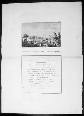
1802 J B Lechevalier Antique Print Temple Apollo Ruins Gülpınar Çanakkale Turkey
- Title : Ruines Du Temple D Apollon Thymbreen; Inscription Trouvee dans les Ruines du Temple d Apollon
- Date : 1802
- Condition: (A+) Fine Condition
- Ref: 70222
- Size: 19 1/4in x 14in (495mm x 355mm)
Description:
This original copper-plate engraved antique print view of the ruins of the Temple of Apollo in the ancient city of Hamaxitus in the Troad region of NW Turkey - with Greek inscription from the temple - was published in the 1802 edition of Jean-Baptiste Lechevaliers of Voyage de la Troade, fait dans les années 1785 et 1786
General Definitions:
Paper thickness and quality: - Heavy and stable
Paper color : - off white
Age of map color: -
Colors used: -
General color appearance: -
Paper size: - 20in x 14in (510mm x 360mm)
Plate size: - 15in x 9 1/2in (380mm x 240mm)
Margins: - Min 1/2in (12mm)
Imperfections:
Margins: - Light soiling
Plate area: - Light toning along centerfold
Verso: - Light soiling
Background:
Hamaxitus was an ancient Greek city in the south-west of the Troad region of Anatolia which was considered to mark the boundary between the Troad and Aeolis. Its surrounding territory was known in Greek as Ἁμαξιτία (Hamaxitia) and included the temple of Apollo Smintheus, the salt pans at Tragasai, and the Satnioeis river (modern Tuzla Çay). It has been located on a rise called Beşiktepe near the village of Gülpınar (previously Külahlı) in the Ayvacık district of Çanakkale Province, Turkey
Jean-Baptiste Lechevalier was the secretary of the Ambassador of France in Constantinople. In the year 1788 he visited the plain of Troy, and was enthusiastically in favour of the theory that the site of Homers Troy was to be found at the village of Bunarbashi. His publication about Troy Voyage de la Troade.....was first published in 1799.
The Troad, also known as Troas, is the historical name of the Biga peninsula (Biga Yarımadası, Τρωάς) in the northwestern part of Anatolia, Turkey. This region now is part of the Çanakkale province of Turkey. Bounded by the Dardanelles to the northwest, by the Aegean Sea to the west and separated from the rest of Anatolia by the massif that forms Mount Ida, the Troad is drained by two main rivers, the Scamander (Karamenderes) and the Simois, which join at the area containing the ruins of Troy. Grenikos, Kebren, Simoeis, Rhesos, Rhodios, Heptaporos and Aisepos were seven rivers of the Troad and the names of the river gods that inhabited each river.
Troy (Ancient Greek: Τροία, Troia or Τροίας, Troias, Truva or Troya) was a city in the far northwest of the region known in late Classical antiquity as Asia Minor, now known as Anatolia in modern Turkey, just south of the southwest mouth of the Dardanelles strait and northwest of Mount Ida. The present-day location is known as Hisarlik. It was the setting of the Trojan War described in the Greek Epic Cycle, in particular in the Iliad, one of the two epic poems attributed to Homer. Metrical evidence from the Iliad and the Odyssey suggests that the name λιον (Ilion) formerly began with a digamma: Ϝίλιον (Wilion); this is also supported by the Hittite name for what is thought to be the same city, Wilusa.
A new capital called Ilium (from Greek: λιον, Ilion) was founded on the site in the reign of the Roman Emperor Augustus. It flourished until the establishment of Constantinople, became a bishopric and declined gradually in the Byzantine era, but is now a Latin Catholic titular see.
In 1865, English archaeologist Frank Calvert excavated trial trenches in a field he had bought from a local farmer at Hisarlik, and in 1868, Heinrich Schliemann, a wealthy German businessman and archaeologist, also began excavating in the area after a chance meeting with Calvert in Çanakkale. These excavations revealed several cities built in succession. Schliemann was at first skeptical about the identification of Hisarlik with Troy, but was persuaded by Calvert and took over Calverts excavations on the eastern half of the Hisarlik site, which was on Calvert\'s property. Troy VII has been identified with the city called Wilusa by the Hittites (the probable origin of the Greek λιον) and is generally (but not conclusively) identified with Homeric Troy.
Today, the hill at Hisarlik has given its name to a small village near the ruins, which supports the tourist trade visiting the Troia archaeological site. It lies within the province of Çanakkale, some 30 km south-west of the provincial capital, also called Çanakkale. The nearest village is Tevfikiye. The map here shows the adapted Scamander estuary with Ilium a little way inland across the Homeric plain. Due to Troys location near the Aegean Sea, the Sea of Marmara, and the Black Sea, it was a central hub for the military and trade(Ref: M&B; Tooley)
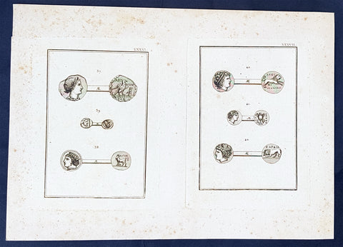
1802 J B Lechevalier Antique Print Ancient Greek Coins - Diana, Algos, Apollo
- Title : Plates: XXXVI (Abydos); XXXVII (Cardia)
- Date : 1802
- Condition: (A+) Fine Condition
- Ref: 70230
- Size: 14in x 10in (355mm x 255mm)
Description:
This original copper-plate engraved antique prints of ancient Greek, Roman & Troy coins (details below) found in the ancient Greek province of Çanakkale, now in the NW of modern Turkey, was published in the 1802 edition of Jean-Baptiste Lechevaliers of Voyage de la Troade, fait dans les années 1785 et 1786
Each plate contains 3 coins;
Plate XXXVI
37. Tete de Diane (The head of Diana)
38. Le nom de cette ville est compose de Aigos (The name of this city is composed of Aigos)
39. Une tete barbue, dans un carre (A bearded head, in a square)
Plate XXXVII
40. Sur les medailles de la meme ville (On the medals of the same city)
41. Le type sait allusion au nom de la ville (The guy knows allusion to the name of the city)
42. Tete de d apollon (Head of Apollo)
General Definitions:
Paper thickness and quality: - Heavy and stable
Paper color : - off white
Age of map color: -
Colors used: -
General color appearance: -
Paper size: - 14in x 10in (355mm x 255mm)
Plate size: - 7in x 5in (180mm x 130mm) each plate
Margins: - Min 1/2in (12mm)
Imperfections:
Margins: - Light soiling
Plate area: - None
Verso: - None
Background:
Jean-Baptiste Lechevalier was the secretary of the Ambassador of France in Constantinople. In the year 1788 he visited the plain of Troy, and was enthusiastically in favour of the theory that the site of Homers Troy was to be found at the village of Bunarbashi. His publication about Troy Voyage de la Troade.....was first published in 1799.
The Troad, also known as Troas, is the historical name of the Biga peninsula (Biga Yarımadası, Τρωάς) in the northwestern part of Anatolia, Turkey. This region now is part of the Çanakkale province of Turkey. Bounded by the Dardanelles to the northwest, by the Aegean Sea to the west and separated from the rest of Anatolia by the massif that forms Mount Ida, the Troad is drained by two main rivers, the Scamander (Karamenderes) and the Simois, which join at the area containing the ruins of Troy. Grenikos, Kebren, Simoeis, Rhesos, Rhodios, Heptaporos and Aisepos were seven rivers of the Troad and the names of the river gods that inhabited each river.
Troy (Ancient Greek: Τροία, Troia or Τροίας, Troias, Truva or Troya) was a city in the far northwest of the region known in late Classical antiquity as Asia Minor, now known as Anatolia in modern Turkey, just south of the southwest mouth of the Dardanelles strait and northwest of Mount Ida. The present-day location is known as Hisarlik. It was the setting of the Trojan War described in the Greek Epic Cycle, in particular in the Iliad, one of the two epic poems attributed to Homer. Metrical evidence from the Iliad and the Odyssey suggests that the name λιον (Ilion) formerly began with a digamma: Ϝίλιον (Wilion); this is also supported by the Hittite name for what is thought to be the same city, Wilusa.
A new capital called Ilium (from Greek: λιον, Ilion) was founded on the site in the reign of the Roman Emperor Augustus. It flourished until the establishment of Constantinople, became a bishopric and declined gradually in the Byzantine era, but is now a Latin Catholic titular see.
In 1865, English archaeologist Frank Calvert excavated trial trenches in a field he had bought from a local farmer at Hisarlik, and in 1868, Heinrich Schliemann, a wealthy German businessman and archaeologist, also began excavating in the area after a chance meeting with Calvert in Çanakkale. These excavations revealed several cities built in succession. Schliemann was at first skeptical about the identification of Hisarlik with Troy, but was persuaded by Calvert and took over Calverts excavations on the eastern half of the Hisarlik site, which was on Calvert\'s property. Troy VII has been identified with the city called Wilusa by the Hittites (the probable origin of the Greek λιον) and is generally (but not conclusively) identified with Homeric Troy.
Today, the hill at Hisarlik has given its name to a small village near the ruins, which supports the tourist trade visiting the Troia archaeological site. It lies within the province of Çanakkale, some 30 km south-west of the provincial capital, also called Çanakkale. The nearest village is Tevfikiye. The map here shows the adapted Scamander estuary with Ilium a little way inland across the Homeric plain. Due to Troys location near the Aegean Sea, the Sea of Marmara, and the Black Sea, it was a central hub for the military and trade(Ref: M&B; Tooley)
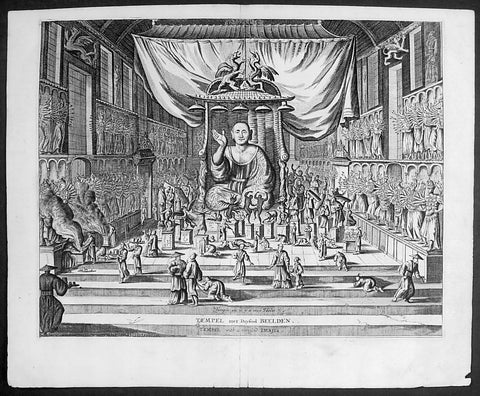
1669 Montanus Antique Print Sanjūsangen-dō 三十三間堂 Buddhist Temple Kyoto, Japan
- Title : Temple ou il y a 1000 Idoles: Temple met Duysend Beelden
- Date : 1669
- Condition: (A+) Fine Condition
- Ref # : 23413
- Size : 14 1/2in x 9in (360mm x 230mm)
Description:
This original copper-plate engraved antique print of Sanjūsangen-dō (三十三間堂) a Buddhist temple in Higashiyama District of Kyoto, Japan (with 1000 Kannon statues) during the Edo period, by Arnoldus Montanus was published in the 1669 edition of Gedenkwaerdige Gesantschappen der Oost-Indische Maetschappy int Vereenigde Nederland, aen de Kaisaren van Japan. Getrokken uit de Geschriften en Reiseaentekeninge der zelver Gesanten (Atlas Japannensis being remarkable addresses by way of Embassy from the East India Company of the United Provinces, to the Emperor of Japan)
General Definitions:
Paper thickness and quality: - Heavy and stable
Paper color : - off white
Age of map color: -
Colors used: -
General color appearance: -
Paper size: - 15in x 12in (380mm x 305mm)
Plate size: - 13in x 10in (330mm x 255mm)
Margins: - Min 1in (20mm)
Imperfections:
Margins: - None
Plate area: - None
Verso: - None
Background:
Sanjūsangen-dō (三十三間堂, lit. thirty-three ken (length) hall) is a Buddhist temple in Higashiyama District of Kyoto, Japan. Officially known as Rengeō-in (蓮華王院), or Hall of the Lotus King, Sanjūsangen-dō belongs to and is run by the Myōhō-in temple, a part of the Tendai school of Buddhism. The temple name literally means Hall with thirty three spaces between columns, describing the architecture of the long main hall of the temple.
Taira no Kiyomori completed the temple under order of Emperor Go-Shirakawa in 1164. The temple complex suffered a fire in 1249 and only the main hall was rebuilt in 1266. In January, the temple has an event known as the Rite of the Willow (柳枝のお加持), where worshippers are touched on the head with a sacred willow branch to cure and prevent headaches. A popular archery tournament known as the Tōshiya (通し矢) has also been held here, beside the West veranda, since the Edo period. The duel between the famous warrior Miyamoto Musashi and Yoshioka Denshichirō, leader of the Yoshioka-ryū, is popularly believed to have been fought just outside Sanjūsangen-dō in 1604.
The main deity of the temple is Sahasrabhuja-arya-avalokiteśvara or the Thousand Armed Kannon. The statue of the main deity was created by the Kamakura sculptor Tankei and is a National Treasure of Japan. The temple also contains one thousand life-size statues of the Thousand Armed Kannon which stand on both the right and left sides of the main statue in 10 rows and 50 columns. Of these, 124 statues are from the original temple, rescued from the fire of 1249, while the remaining 876 statues were constructed in the 13th century. The statues are made of Japanese cypress clad in gold leaf. The temple is 120 - meter long[1]. Around the 1000 Kannon statues stand 28 statues of guardian deities. There are also two famous statues of Fūjin and Raijin.
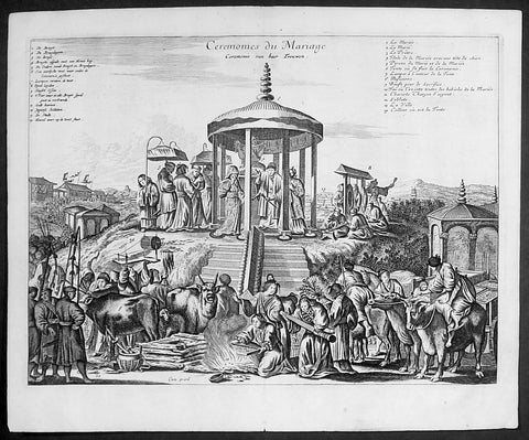
1669 Arnoldus Montanus Large Antique Print of a Japanese Marriage Ceremony 結婚式
- Title : Ceremonies du Mariage
- Date : 1669
- Condition: (A+) Fine Condition
- Ref # : 23411-1
- Size : 14 1/2in x 9in (360mm x 230mm)
Description:
This original copper-plate engraved antique print of a Japanese Marriage Ceremony during the early Edo period of Japanese history, by Arnoldus Montanus was published in the 1669 edition of Gedenkwaerdige Gesantschappen der Oost-Indische Maetschappy int Vereenigde Nederland, aen de Kaisaren van Japan. Getrokken uit de Geschriften en Reiseaentekeninge der zelver Gesanten (Atlas Japannensis being remarkable addresses by way of Embassy from the East India Company of the United Provinces, to the Emperor of Japan)
General Definitions:
Paper thickness and quality: - Heavy and stable
Paper color : - off white
Age of map color: -
Colors used: -
General color appearance: -
Paper size: - 15in x 12in (380mm x 305mm)
Plate size: - 13in x 10in (330mm x 255mm)
Margins: - Min 1in (20mm)
Imperfections:
Margins: - None
Plate area: - None
Verso: - None
Background:
Marriage in the Edo period (1600–1868)
In pre-modern Japan, marriage was inextricable from the ie (家, family or household), the basic unit of society with a collective continuity independent of any individual life. Members of the household were expected to subordinate all their own interests to that of the ie, with respect for an ideal of filial piety and social hierarchy that borrowed much from Confucianism. The choice to remain single was the greatest crime a man could commit, according to Baron Hozumi.
Marriages were duly arranged by the head of the household, who represented it publicly and was legally responsible for its members, and any preference by either principal in a marital arrangement was considered improper. Property was regarded to belong to the ie rather than to individuals, and inheritance was strictly agnatic primogeniture. A woman (女) married the household (家) of her husband, hence the logograms for yome (嫁, wife) and yomeiri (嫁入り, marriage, lit. wife entering).
In the absence of sons, some households would adopt a male heir (養子, or yōshi) to maintain the dynasty, a practice which continues in corporate Japan. Nearly all adoptions are of adult men. Marriage was restricted to households of equal social standing (分限), which made selection a crucial, painstaking process. Although Confucian ethics encouraged people to marry outside their own group, limiting the search to a local community remained the easiest way to ensure an honorable match. Approximately one-in-five marriages in pre-modern Japan occurred between households that were already related.
Outcast communities such as the Burakumin could not marry outside of their caste, and marriage discrimination continued even after an 1871 edict abolished the caste system, well into the twentieth century. Marriage between a Japanese and non-Japanese person was not officially permitted until 14 March 1873, a date now commemorated as White Day. Marriage with a foreigner required the Japanese national to surrender his or her social standing.
The purposes of marriage in the medieval and Edo periods was to form alliances between families, to relieve the family of its female dependents, to perpetuate the family line, and, especially for the lower classes, to add new members to the family\'s workforce. The seventeenth-century treatise Onna Daigaku (Greater Learning for Women) instructed wives honor their parents-in-law before their own parents, and to be courteous, humble, and conciliatory towards their husbands.
Husbands were also encouraged to place the needs of their parents and children before those of their wives. One British observer remarked, If you love your wife you spoil your mother\'s servant. The tension between a housewife and her mother-in-law has been a keynote of Japanese drama ever since.
Romantic love (愛情, aijō) played little part in medieval marriages, as emotional attachment was considered inconsistent with filial piety. A proverb said, Those who come together in passion stay together in tears. For men, sexual gratification was seen as separate from conjugal relations with ones wife, where the purpose was procreation. The genre called Ukiyo-e (浮世絵, lit. floating world pictures) celebrated the luxury and hedonism of the era, typically with depictions of beautiful courtesans and geisha of the pleasure districts. Concubinage and prostitution were common, public, relatively respectable, until the social upheaval of the Meiji Restoration put an end to feudal society in Japan.
1789 Jean Baptiste Lamarck Antique Concology Print, Seawater Clam Shells, Pl 262
- Title : Donace, Donax
- Size: 11in x 8in (280mm x 205mm)
- Condition: (A+) Fine Condition
- Date : 1789
- Ref #: 23893
Description:
This fine original copper-plate engraved antique Conchology or Shell print by Jean Baptiste Lamarck was drawn by Henri Joseph Redoute (1766 - 1852) - younger brother of the famous illustrator P J Redoute - engraved by Robert Benard and published in the 1789 edition of Tableau encyclopédique et méthodique des trois règnes de la nature(1782-1832) by the French publisher Charles Joseph Panckoucke.
General Definitions:
Paper thickness and quality: - Heavy and stable
Paper color : - Off white
Age of map color: - Original
Colors used: - Yellow, Green, pink
General color appearance: - Authentic
Paper size: - 11in x 8in (280mm x 205mm)
Plate size: - 10in x 7in (255mm x 180mm)
Margins: - Min 1/2in (12mm)
Imperfections:
Margins: - None
Plate area: - None
Verso: - None
Background:
Tableau encyclopédique et méthodique des trois regnes de la nature was an illustrated encyclopedia of plants, animals and minerals, notable for including the first scientific descriptions of many species, and for its attractive engravings. It was published in Paris by Charles Joseph Panckoucke, from 1788 on. Although its several volumes can be considered a part of the greater Encyclopédie méthodique, they were titled and issued separately.
Encyclopédie méthodique par ordre des matières (Methodical Encyclopedia by Order of Subject Matter) was published between 1782 and 1832 by the French publisher Charles Joseph Panckoucke, his son-in-law Henri Agasse, and the latter´s wife, Thérèse-Charlotte Agasse. Arranged by disciplines, it was a revised and much expanded version, in roughly 210 to 216 volumes (different sets were bound differently), of the alphabetically arranged Encyclopédie, edited by Denis Diderot and Jean le Rond d Alembert.
Two sets of Diderots Encyclopédie and its supplements were cut up into articles. Each subject category was entrusted to a specialized editor, whose job was to collect all articles relating to his subject and exclude those belonging to others. Great care was to be taken of those articles that were of a doubtful nature, which were not to be omitted. For certain topics, such as air (which belonged equally to chemistry, physics and medicine), the methodical arrangement had the unexpected effect of breaking up a single article into several parts. Each volume was to have its own introduction, a table of contents, and a history of the Encyclopédie. The whole work was to be linked together by a Vocabulaire universel (Vol. 1 – 4), with references to all locations where each word appears.
The prospectus, issued early in 1782, proposed three editions, each with seven volumes of 250 to 300 plates:
84 volumes;
43 volumes, with 3 columns per page; and
53 volumes of about 100 sheets, with 2 columns per page.
The publication was continued by Henri Agasse, Panckouckes son-in-law, from 1794 to 1813, and then by the latters widow, Mme Agasse, until 1832, when it was completed in 102 livraisons or 337 parts, forming roughly 166½ volumes of text (depending on how the parts were bound) as well as 51 illustrated parts containing 6,439 plates. The number of pages totalled 124,210 pages, of which 5,458 pages were plates. To save money, the plates belonging to architecture were not published. Pharmacy (separated from chemistry), minerals, education, Ponts et chausses were not published as had been announced.
Many dictionaries have a classed index of articles. The one in Oeconomie politique is an excellent example, giving the contents of each article, so that any passage can be found easily.
When completed, the encyclopedia suffered at least one great weakness. As the Vocabulaire Universel, the key and index to the entire work, was not published, it was difficult to carry out any research or to find all the articles on any particular subject. The original parts had often been subdivided, and had been so added onto by other dictionaries, supplements, and appendices that an exact account could not be given of the work, which contained 88 alphabets, 83 indexes, 166 introductions, discourses, prefaces, etc. Overall, probably no more an unmanageable body of dictionaries has ever been published, except Jacques Paul Mignes Encyclopédie théologique, Paris, 1844–1875, with 168 volumes, 101 dictionaries, and 119,059 pages.
The Encyclopédie méthodique par ordre des matières occupied a thousand workers in production, and 2,250 contributors.
Lamarck, Jean-Baptiste Pierre Antoine de Monet, Chevalier de1744 – 1829
Lamarck was a pioneer French biologist, who is best known for his idea that acquired characters are inheritable, an idea known as Lamarckism, which is controverted by modern evolutionary theorygenetics.
Lamarck was the youngest of 11 children in a family of the lesser nobility. His family intended him for the priesthood, but, after the death of his father and the expulsion of the Jesuits from France, Lamarck embarked on a military career in 1761. As a soldier garrisoned in the south of France, he became interested in collecting plants. An injury forced him to resign in 1768, but his fascination for botany endured, and it was as a botanist that he first built his scientific reputation.
Lamarck gained attention among the naturalists in Paris at the Jardin et Cabinet du Roi (the kings garden and natural history collection, known informally as the Jardin du Roi) by claiming he could create a system for identifying the plants of France that would be more efficient than any system currently in existence, including that of the great Swedish naturalist Carolus Linnaeus. This project appealed to Georges-Louis Leclerc, comte de Buffon, who was the director of the Jardin du Roi and Linnaeuss greatest rival. Buffon arranged to have Lamarcks work published at government expense, and Lamarck received the proceeds from the sales. The work appeared in three volumes under the title Flore française (1778; French Flora). Lamarck designed the Flore française specifically for the task of plant identification and used dichotomous keys, which are classification tools that allow the user to choose between opposing pairs of morphological characters (see taxonomy: The objectives of biological classification) to achieve this end.
With Buffons support, Lamarck was elected to the Academy of Sciences in 1779. Two years later Buffon named Lamarck correspondent of the Jardin du Roi, evidently to give Lamarck additional status while he escorted Buffons son on a scientific tour of Europe. This provided Lamarck with his first official connection, albeit an unsalaried one, with the Jardin du Roi. Shortly after Buffons death in 1788, his successor, Flahault de la Billarderie, created a salaried position for Lamarck with the title of botanist of the King and keeper of the Kings herbaria.
Between 1783 and 1792 Lamarck published three large botanical volumes for the Encyclopédie méthodique (Methodical Encyclopaedia) , a massive publishing enterprise begun by French publisher Charles-Joseph Panckoucke in the late 18th century. Lamarck also published botanical papers in the Mémoires of the Academy of Sciences. In 1792 he cofounded and coedited a short-lived journal of natural history, the Journal dhistoire naturelle.
Lamarcks career changed dramatically in 1793 when the former Jardin du Roi was transformed into the Muséum National dHistoire Naturelle (National Museum of Natural History). In the changeover, all 12 of the scientists who had been officers of the previous establishment were named as professors and coadministrators of the new institution; however, only two professorships of botany were created. The botanists Antoine-Laurent de Jussieu and René Desfontaines held greater claims to these positions, and Lamarck, in a striking shift of responsibilities, was made professor of the insects, worms, and microscopic animals. Although this change of focus was remarkable, it was not wholly unjustified, as Lamarck was an ardent shell collector. Lamarck then set out to classify this large and poorly analyzed expanse of the animal kingdom. Later he would name this group animals without vertebrae and invent the term invertebrate. By 1802 Lamarck had also introduced the term biology.
This challenge would have been enough to occupy the energies of most naturalists; however, Lamarcks intellectual aspirations ran well beyond that of reforming invertebrate classification. In the 1790s he began promoting the broad theories of physics, chemistry, and meteorology that he had been nurturing for almost two decades. He also began thinking about Earths geologic history and developed notions that he would eventually publish under the title of Hydrogéologie (1802). In his physico-chemical writings, he advanced an old-fashioned, four-element theory that was self-consciously at odds with the revolutionary advances of the emerging pneumatic chemistry of Antoine-Laurent Lavoisier. His colleagues at the Institute of France (the successor to the Academy of Sciences) saw Lamarcks broad theorizing as unscientific system building. Lamarck in turn became increasingly scornful of scientists who preferred small facts to larger, more important ones. He began to characterize himself as a naturalist-philosopher, a person more concerned with the broader processes of nature than the details of the chemists laboratory or naturalists closet.
In 1800 Lamarck first set forth the revolutionary notion of species mutability during a lecture to students in his invertebrate zoology class at the National Museum of Natural History. By 1802 the general outlines of his broad theory of organic transformation had taken shape. He presented the theory successively in his Recherches sur lorganisation des corps vivans (1802; Research on the Organization of Living Bodies), his Philosophie zoologique (1809; Zoological Philosophy), and the introduction to his great multivolume work on invertebrate classification, Histoire naturelle des animaux sans vertèbres (1815–22; Natural History of Invertebrate Animals) . Lamarcks theory of organic development included the idea that the very simplest forms of plant and animal life were the result of spontaneous generation. Life became successively diversified, he claimed, as the result of two very different sorts of causes. He called the first the power of life, or the cause that tends to make organization increasingly complex, whereas he classified the second as the modifying influence of particular circumstances (that is, the effects of the environment). He explained this in his Philosophie zoologique : The state in which we now see all the animals is on the one hand the product of the increasing composition of organization, which tends to form a regular gradation, and on the other hand that of the influences of a multitude of very different circumstances that continually tend to destroy the regularity in the gradation of the increasing composition of organization.
With this theory, Lamarck offered much more than an account of how species change. He also explained what he understood to be the shape of a truly natural system of classification of the animal kingdom. The primary feature of this system was a single scale of increasing complexity composed of all the different classes of animals, starting with the simplest microscopic organisms, or infusorians, and rising up to the mammals. The species, however, could not be arranged in a simple series. Lamarck described them as forming lateral ramifications with respect to the general masses of organization represented by the classes. Lateral ramifications in species resulted when they underwent transformations that reflected the diverse, particular environments to which they had been exposed.
By Lamarcks account, animals, in responding to different environments, adopted new habits. Their new habits caused them to use some organs more and some organs less, which resulted in the strengthening of the former and the weakening of the latter. New characters thus acquired by organisms over the course of their lives were passed on to the next generation (provided, in the case of sexual reproduction, that both of the parents of the offspring had undergone the same changes). Small changes that accumulated over great periods of time produced major differences. Lamarck thus explained how the shapes of giraffes, snakes, storks, swans, and numerous other creatures were a consequence of long-maintained habits. The basic idea of the inheritance of acquired characters had originated with Anaxagoras, Hippocrates, and others, but Lamarck was essentially the first naturalist to argue at length that the long-term operation of this process could result in species change.
Later in the century, after English naturalist Charles Darwin advanced his theory of evolution by natural selection, the idea of the inheritance of acquired characters came to be identified as a distinctively Lamarckian view of organic change (though Darwin himself also believed that acquired characters could be inherited). The idea was not seriously challenged in biology until the German biologist August Weismann did so in the 1880s. In the 20th century, since Lamarcks idea failed to be confirmed experimentally and the evidence commonly cited in its favour was given different interpretations, it became thoroughly discredited. Epigenetics, the study of the chemical modification of genes and gene-associated proteins, has since offered an explanation for how certain traits developed during an organisms lifetime can be passed along to its offspring.
Lamarck made his most important contributions to science as a botanical and zoological systematist, as a founder of invertebrate paleontology, and as an evolutionary theorist. In his own day, his theory of evolution was generally rejected as implausible, unsubstantiated, or heretical. Today he is primarily remembered for his notion of the inheritance of acquired characteristics. Nonetheless, Lamarck stands out in the history of biology as the first writer to set forth—both systematically and in detail—a comprehensive theory of organic evolution that accounted for the successive production of all the different forms of life on Earth.
1789 Jean Baptiste Lamarck Antique Concology Print, Seawater Clam Shells, Pl 283
- Title : Venus, Venus
- Size: 11in x 8in (280mm x 205mm)
- Condition: (A+) Fine Condition
- Date : 1789
- Ref #: 23914
Description:
This fine original copper-plate engraved antique Conchology or Shell print by Jean Baptiste Lamarck was drawn by Henri Joseph Redoute (1766 - 1852) - younger brother of the famous illustrator P J Redoute - engraved by Robert Benard and published in the 1789 edition of Tableau encyclopédique et méthodique des trois règnes de la nature(1782-1832) by the French publisher Charles Joseph Panckoucke.
General Definitions:
Paper thickness and quality: - Heavy and stable
Paper color : - Off white
Age of map color: - Original
Colors used: - Yellow, Green, pink
General color appearance: - Authentic
Paper size: - 11in x 8in (280mm x 205mm)
Plate size: - 10in x 7in (255mm x 180mm)
Margins: - Min 1/2in (12mm)
Imperfections:
Margins: - None
Plate area: - None
Verso: - None
Background:
Tableau encyclopédique et méthodique des trois regnes de la nature was an illustrated encyclopedia of plants, animals and minerals, notable for including the first scientific descriptions of many species, and for its attractive engravings. It was published in Paris by Charles Joseph Panckoucke, from 1788 on. Although its several volumes can be considered a part of the greater Encyclopédie méthodique, they were titled and issued separately.
Encyclopédie méthodique par ordre des matières (Methodical Encyclopedia by Order of Subject Matter) was published between 1782 and 1832 by the French publisher Charles Joseph Panckoucke, his son-in-law Henri Agasse, and the latter´s wife, Thérèse-Charlotte Agasse. Arranged by disciplines, it was a revised and much expanded version, in roughly 210 to 216 volumes (different sets were bound differently), of the alphabetically arranged Encyclopédie, edited by Denis Diderot and Jean le Rond d Alembert.
Two sets of Diderots Encyclopédie and its supplements were cut up into articles. Each subject category was entrusted to a specialized editor, whose job was to collect all articles relating to his subject and exclude those belonging to others. Great care was to be taken of those articles that were of a doubtful nature, which were not to be omitted. For certain topics, such as air (which belonged equally to chemistry, physics and medicine), the methodical arrangement had the unexpected effect of breaking up a single article into several parts. Each volume was to have its own introduction, a table of contents, and a history of the Encyclopédie. The whole work was to be linked together by a Vocabulaire universel (Vol. 1 – 4), with references to all locations where each word appears.
The prospectus, issued early in 1782, proposed three editions, each with seven volumes of 250 to 300 plates:
84 volumes;
43 volumes, with 3 columns per page; and
53 volumes of about 100 sheets, with 2 columns per page.
The publication was continued by Henri Agasse, Panckouckes son-in-law, from 1794 to 1813, and then by the latters widow, Mme Agasse, until 1832, when it was completed in 102 livraisons or 337 parts, forming roughly 166½ volumes of text (depending on how the parts were bound) as well as 51 illustrated parts containing 6,439 plates. The number of pages totalled 124,210 pages, of which 5,458 pages were plates. To save money, the plates belonging to architecture were not published. Pharmacy (separated from chemistry), minerals, education, Ponts et chausses were not published as had been announced.
Many dictionaries have a classed index of articles. The one in Oeconomie politique is an excellent example, giving the contents of each article, so that any passage can be found easily.
When completed, the encyclopedia suffered at least one great weakness. As the Vocabulaire Universel, the key and index to the entire work, was not published, it was difficult to carry out any research or to find all the articles on any particular subject. The original parts had often been subdivided, and had been so added onto by other dictionaries, supplements, and appendices that an exact account could not be given of the work, which contained 88 alphabets, 83 indexes, 166 introductions, discourses, prefaces, etc. Overall, probably no more an unmanageable body of dictionaries has ever been published, except Jacques Paul Mignes Encyclopédie théologique, Paris, 1844–1875, with 168 volumes, 101 dictionaries, and 119,059 pages.
The Encyclopédie méthodique par ordre des matières occupied a thousand workers in production, and 2,250 contributors.
Lamarck, Jean-Baptiste Pierre Antoine de Monet, Chevalier de1744 – 1829
Lamarck was a pioneer French biologist, who is best known for his idea that acquired characters are inheritable, an idea known as Lamarckism, which is controverted by modern evolutionary theorygenetics.
Lamarck was the youngest of 11 children in a family of the lesser nobility. His family intended him for the priesthood, but, after the death of his father and the expulsion of the Jesuits from France, Lamarck embarked on a military career in 1761. As a soldier garrisoned in the south of France, he became interested in collecting plants. An injury forced him to resign in 1768, but his fascination for botany endured, and it was as a botanist that he first built his scientific reputation.
Lamarck gained attention among the naturalists in Paris at the Jardin et Cabinet du Roi (the kings garden and natural history collection, known informally as the Jardin du Roi) by claiming he could create a system for identifying the plants of France that would be more efficient than any system currently in existence, including that of the great Swedish naturalist Carolus Linnaeus. This project appealed to Georges-Louis Leclerc, comte de Buffon, who was the director of the Jardin du Roi and Linnaeuss greatest rival. Buffon arranged to have Lamarcks work published at government expense, and Lamarck received the proceeds from the sales. The work appeared in three volumes under the title Flore française (1778; French Flora). Lamarck designed the Flore française specifically for the task of plant identification and used dichotomous keys, which are classification tools that allow the user to choose between opposing pairs of morphological characters (see taxonomy: The objectives of biological classification) to achieve this end.
With Buffons support, Lamarck was elected to the Academy of Sciences in 1779. Two years later Buffon named Lamarck correspondent of the Jardin du Roi, evidently to give Lamarck additional status while he escorted Buffons son on a scientific tour of Europe. This provided Lamarck with his first official connection, albeit an unsalaried one, with the Jardin du Roi. Shortly after Buffons death in 1788, his successor, Flahault de la Billarderie, created a salaried position for Lamarck with the title of botanist of the King and keeper of the Kings herbaria.
Between 1783 and 1792 Lamarck published three large botanical volumes for the Encyclopédie méthodique (Methodical Encyclopaedia) , a massive publishing enterprise begun by French publisher Charles-Joseph Panckoucke in the late 18th century. Lamarck also published botanical papers in the Mémoires of the Academy of Sciences. In 1792 he cofounded and coedited a short-lived journal of natural history, the Journal dhistoire naturelle.
Lamarcks career changed dramatically in 1793 when the former Jardin du Roi was transformed into the Muséum National dHistoire Naturelle (National Museum of Natural History). In the changeover, all 12 of the scientists who had been officers of the previous establishment were named as professors and coadministrators of the new institution; however, only two professorships of botany were created. The botanists Antoine-Laurent de Jussieu and René Desfontaines held greater claims to these positions, and Lamarck, in a striking shift of responsibilities, was made professor of the insects, worms, and microscopic animals. Although this change of focus was remarkable, it was not wholly unjustified, as Lamarck was an ardent shell collector. Lamarck then set out to classify this large and poorly analyzed expanse of the animal kingdom. Later he would name this group animals without vertebrae and invent the term invertebrate. By 1802 Lamarck had also introduced the term biology.
This challenge would have been enough to occupy the energies of most naturalists; however, Lamarcks intellectual aspirations ran well beyond that of reforming invertebrate classification. In the 1790s he began promoting the broad theories of physics, chemistry, and meteorology that he had been nurturing for almost two decades. He also began thinking about Earths geologic history and developed notions that he would eventually publish under the title of Hydrogéologie (1802). In his physico-chemical writings, he advanced an old-fashioned, four-element theory that was self-consciously at odds with the revolutionary advances of the emerging pneumatic chemistry of Antoine-Laurent Lavoisier. His colleagues at the Institute of France (the successor to the Academy of Sciences) saw Lamarcks broad theorizing as unscientific system building. Lamarck in turn became increasingly scornful of scientists who preferred small facts to larger, more important ones. He began to characterize himself as a naturalist-philosopher, a person more concerned with the broader processes of nature than the details of the chemists laboratory or naturalists closet.
In 1800 Lamarck first set forth the revolutionary notion of species mutability during a lecture to students in his invertebrate zoology class at the National Museum of Natural History. By 1802 the general outlines of his broad theory of organic transformation had taken shape. He presented the theory successively in his Recherches sur lorganisation des corps vivans (1802; Research on the Organization of Living Bodies), his Philosophie zoologique (1809; Zoological Philosophy), and the introduction to his great multivolume work on invertebrate classification, Histoire naturelle des animaux sans vertèbres (1815–22; Natural History of Invertebrate Animals) . Lamarcks theory of organic development included the idea that the very simplest forms of plant and animal life were the result of spontaneous generation. Life became successively diversified, he claimed, as the result of two very different sorts of causes. He called the first the power of life, or the cause that tends to make organization increasingly complex, whereas he classified the second as the modifying influence of particular circumstances (that is, the effects of the environment). He explained this in his Philosophie zoologique : The state in which we now see all the animals is on the one hand the product of the increasing composition of organization, which tends to form a regular gradation, and on the other hand that of the influences of a multitude of very different circumstances that continually tend to destroy the regularity in the gradation of the increasing composition of organization.
With this theory, Lamarck offered much more than an account of how species change. He also explained what he understood to be the shape of a truly natural system of classification of the animal kingdom. The primary feature of this system was a single scale of increasing complexity composed of all the different classes of animals, starting with the simplest microscopic organisms, or infusorians, and rising up to the mammals. The species, however, could not be arranged in a simple series. Lamarck described them as forming lateral ramifications with respect to the general masses of organization represented by the classes. Lateral ramifications in species resulted when they underwent transformations that reflected the diverse, particular environments to which they had been exposed.
By Lamarcks account, animals, in responding to different environments, adopted new habits. Their new habits caused them to use some organs more and some organs less, which resulted in the strengthening of the former and the weakening of the latter. New characters thus acquired by organisms over the course of their lives were passed on to the next generation (provided, in the case of sexual reproduction, that both of the parents of the offspring had undergone the same changes). Small changes that accumulated over great periods of time produced major differences. Lamarck thus explained how the shapes of giraffes, snakes, storks, swans, and numerous other creatures were a consequence of long-maintained habits. The basic idea of the inheritance of acquired characters had originated with Anaxagoras, Hippocrates, and others, but Lamarck was essentially the first naturalist to argue at length that the long-term operation of this process could result in species change.
Later in the century, after English naturalist Charles Darwin advanced his theory of evolution by natural selection, the idea of the inheritance of acquired characters came to be identified as a distinctively Lamarckian view of organic change (though Darwin himself also believed that acquired characters could be inherited). The idea was not seriously challenged in biology until the German biologist August Weismann did so in the 1880s. In the 20th century, since Lamarcks idea failed to be confirmed experimentally and the evidence commonly cited in its favour was given different interpretations, it became thoroughly discredited. Epigenetics, the study of the chemical modification of genes and gene-associated proteins, has since offered an explanation for how certain traits developed during an organisms lifetime can be passed along to its offspring.
Lamarck made his most important contributions to science as a botanical and zoological systematist, as a founder of invertebrate paleontology, and as an evolutionary theorist. In his own day, his theory of evolution was generally rejected as implausible, unsubstantiated, or heretical. Today he is primarily remembered for his notion of the inheritance of acquired characteristics. Nonetheless, Lamarck stands out in the history of biology as the first writer to set forth—both systematically and in detail—a comprehensive theory of organic evolution that accounted for the successive production of all the different forms of life on Earth.
1789 Jean Baptiste Lamarck Antique Concology Print, Seawater Clam Shells, Pl 280
- Title : Venus, Venus
- Size: 11in x 8in (280mm x 205mm)
- Condition: (A+) Fine Condition
- Date : 1789
- Ref #: 23911
Description:
This fine original copper-plate engraved antique Conchology or Shell print by Jean Baptiste Lamarck was drawn by Henri Joseph Redoute (1766 - 1852) - younger brother of the famous illustrator P J Redoute - engraved by Robert Benard and published in the 1789 edition of Tableau encyclopédique et méthodique des trois règnes de la nature(1782-1832) by the French publisher Charles Joseph Panckoucke.
General Definitions:
Paper thickness and quality: - Heavy and stable
Paper color : - Off white
Age of map color: - Original
Colors used: - Yellow, Green, pink
General color appearance: - Authentic
Paper size: - 11in x 8in (280mm x 205mm)
Plate size: - 10in x 7in (255mm x 180mm)
Margins: - Min 1/2in (12mm)
Imperfections:
Margins: - None
Plate area: - None
Verso: - None
Background:
Tableau encyclopédique et méthodique des trois regnes de la nature was an illustrated encyclopedia of plants, animals and minerals, notable for including the first scientific descriptions of many species, and for its attractive engravings. It was published in Paris by Charles Joseph Panckoucke, from 1788 on. Although its several volumes can be considered a part of the greater Encyclopédie méthodique, they were titled and issued separately.
Encyclopédie méthodique par ordre des matières (Methodical Encyclopedia by Order of Subject Matter) was published between 1782 and 1832 by the French publisher Charles Joseph Panckoucke, his son-in-law Henri Agasse, and the latter´s wife, Thérèse-Charlotte Agasse. Arranged by disciplines, it was a revised and much expanded version, in roughly 210 to 216 volumes (different sets were bound differently), of the alphabetically arranged Encyclopédie, edited by Denis Diderot and Jean le Rond d Alembert.
Two sets of Diderots Encyclopédie and its supplements were cut up into articles. Each subject category was entrusted to a specialized editor, whose job was to collect all articles relating to his subject and exclude those belonging to others. Great care was to be taken of those articles that were of a doubtful nature, which were not to be omitted. For certain topics, such as air (which belonged equally to chemistry, physics and medicine), the methodical arrangement had the unexpected effect of breaking up a single article into several parts. Each volume was to have its own introduction, a table of contents, and a history of the Encyclopédie. The whole work was to be linked together by a Vocabulaire universel (Vol. 1 – 4), with references to all locations where each word appears.
The prospectus, issued early in 1782, proposed three editions, each with seven volumes of 250 to 300 plates:
84 volumes;
43 volumes, with 3 columns per page; and
53 volumes of about 100 sheets, with 2 columns per page.
The publication was continued by Henri Agasse, Panckouckes son-in-law, from 1794 to 1813, and then by the latters widow, Mme Agasse, until 1832, when it was completed in 102 livraisons or 337 parts, forming roughly 166½ volumes of text (depending on how the parts were bound) as well as 51 illustrated parts containing 6,439 plates. The number of pages totalled 124,210 pages, of which 5,458 pages were plates. To save money, the plates belonging to architecture were not published. Pharmacy (separated from chemistry), minerals, education, Ponts et chausses were not published as had been announced.
Many dictionaries have a classed index of articles. The one in Oeconomie politique is an excellent example, giving the contents of each article, so that any passage can be found easily.
When completed, the encyclopedia suffered at least one great weakness. As the Vocabulaire Universel, the key and index to the entire work, was not published, it was difficult to carry out any research or to find all the articles on any particular subject. The original parts had often been subdivided, and had been so added onto by other dictionaries, supplements, and appendices that an exact account could not be given of the work, which contained 88 alphabets, 83 indexes, 166 introductions, discourses, prefaces, etc. Overall, probably no more an unmanageable body of dictionaries has ever been published, except Jacques Paul Mignes Encyclopédie théologique, Paris, 1844–1875, with 168 volumes, 101 dictionaries, and 119,059 pages.
The Encyclopédie méthodique par ordre des matières occupied a thousand workers in production, and 2,250 contributors.
Lamarck, Jean-Baptiste Pierre Antoine de Monet, Chevalier de1744 – 1829
Lamarck was a pioneer French biologist, who is best known for his idea that acquired characters are inheritable, an idea known as Lamarckism, which is controverted by modern evolutionary theorygenetics.
Lamarck was the youngest of 11 children in a family of the lesser nobility. His family intended him for the priesthood, but, after the death of his father and the expulsion of the Jesuits from France, Lamarck embarked on a military career in 1761. As a soldier garrisoned in the south of France, he became interested in collecting plants. An injury forced him to resign in 1768, but his fascination for botany endured, and it was as a botanist that he first built his scientific reputation.
Lamarck gained attention among the naturalists in Paris at the Jardin et Cabinet du Roi (the kings garden and natural history collection, known informally as the Jardin du Roi) by claiming he could create a system for identifying the plants of France that would be more efficient than any system currently in existence, including that of the great Swedish naturalist Carolus Linnaeus. This project appealed to Georges-Louis Leclerc, comte de Buffon, who was the director of the Jardin du Roi and Linnaeuss greatest rival. Buffon arranged to have Lamarcks work published at government expense, and Lamarck received the proceeds from the sales. The work appeared in three volumes under the title Flore française (1778; French Flora). Lamarck designed the Flore française specifically for the task of plant identification and used dichotomous keys, which are classification tools that allow the user to choose between opposing pairs of morphological characters (see taxonomy: The objectives of biological classification) to achieve this end.
With Buffons support, Lamarck was elected to the Academy of Sciences in 1779. Two years later Buffon named Lamarck correspondent of the Jardin du Roi, evidently to give Lamarck additional status while he escorted Buffons son on a scientific tour of Europe. This provided Lamarck with his first official connection, albeit an unsalaried one, with the Jardin du Roi. Shortly after Buffons death in 1788, his successor, Flahault de la Billarderie, created a salaried position for Lamarck with the title of botanist of the King and keeper of the Kings herbaria.
Between 1783 and 1792 Lamarck published three large botanical volumes for the Encyclopédie méthodique (Methodical Encyclopaedia) , a massive publishing enterprise begun by French publisher Charles-Joseph Panckoucke in the late 18th century. Lamarck also published botanical papers in the Mémoires of the Academy of Sciences. In 1792 he cofounded and coedited a short-lived journal of natural history, the Journal dhistoire naturelle.
Lamarcks career changed dramatically in 1793 when the former Jardin du Roi was transformed into the Muséum National dHistoire Naturelle (National Museum of Natural History). In the changeover, all 12 of the scientists who had been officers of the previous establishment were named as professors and coadministrators of the new institution; however, only two professorships of botany were created. The botanists Antoine-Laurent de Jussieu and René Desfontaines held greater claims to these positions, and Lamarck, in a striking shift of responsibilities, was made professor of the insects, worms, and microscopic animals. Although this change of focus was remarkable, it was not wholly unjustified, as Lamarck was an ardent shell collector. Lamarck then set out to classify this large and poorly analyzed expanse of the animal kingdom. Later he would name this group animals without vertebrae and invent the term invertebrate. By 1802 Lamarck had also introduced the term biology.
This challenge would have been enough to occupy the energies of most naturalists; however, Lamarcks intellectual aspirations ran well beyond that of reforming invertebrate classification. In the 1790s he began promoting the broad theories of physics, chemistry, and meteorology that he had been nurturing for almost two decades. He also began thinking about Earths geologic history and developed notions that he would eventually publish under the title of Hydrogéologie (1802). In his physico-chemical writings, he advanced an old-fashioned, four-element theory that was self-consciously at odds with the revolutionary advances of the emerging pneumatic chemistry of Antoine-Laurent Lavoisier. His colleagues at the Institute of France (the successor to the Academy of Sciences) saw Lamarcks broad theorizing as unscientific system building. Lamarck in turn became increasingly scornful of scientists who preferred small facts to larger, more important ones. He began to characterize himself as a naturalist-philosopher, a person more concerned with the broader processes of nature than the details of the chemists laboratory or naturalists closet.
In 1800 Lamarck first set forth the revolutionary notion of species mutability during a lecture to students in his invertebrate zoology class at the National Museum of Natural History. By 1802 the general outlines of his broad theory of organic transformation had taken shape. He presented the theory successively in his Recherches sur lorganisation des corps vivans (1802; Research on the Organization of Living Bodies), his Philosophie zoologique (1809; Zoological Philosophy), and the introduction to his great multivolume work on invertebrate classification, Histoire naturelle des animaux sans vertèbres (1815–22; Natural History of Invertebrate Animals) . Lamarcks theory of organic development included the idea that the very simplest forms of plant and animal life were the result of spontaneous generation. Life became successively diversified, he claimed, as the result of two very different sorts of causes. He called the first the power of life, or the cause that tends to make organization increasingly complex, whereas he classified the second as the modifying influence of particular circumstances (that is, the effects of the environment). He explained this in his Philosophie zoologique : The state in which we now see all the animals is on the one hand the product of the increasing composition of organization, which tends to form a regular gradation, and on the other hand that of the influences of a multitude of very different circumstances that continually tend to destroy the regularity in the gradation of the increasing composition of organization.
With this theory, Lamarck offered much more than an account of how species change. He also explained what he understood to be the shape of a truly natural system of classification of the animal kingdom. The primary feature of this system was a single scale of increasing complexity composed of all the different classes of animals, starting with the simplest microscopic organisms, or infusorians, and rising up to the mammals. The species, however, could not be arranged in a simple series. Lamarck described them as forming lateral ramifications with respect to the general masses of organization represented by the classes. Lateral ramifications in species resulted when they underwent transformations that reflected the diverse, particular environments to which they had been exposed.
By Lamarcks account, animals, in responding to different environments, adopted new habits. Their new habits caused them to use some organs more and some organs less, which resulted in the strengthening of the former and the weakening of the latter. New characters thus acquired by organisms over the course of their lives were passed on to the next generation (provided, in the case of sexual reproduction, that both of the parents of the offspring had undergone the same changes). Small changes that accumulated over great periods of time produced major differences. Lamarck thus explained how the shapes of giraffes, snakes, storks, swans, and numerous other creatures were a consequence of long-maintained habits. The basic idea of the inheritance of acquired characters had originated with Anaxagoras, Hippocrates, and others, but Lamarck was essentially the first naturalist to argue at length that the long-term operation of this process could result in species change.
Later in the century, after English naturalist Charles Darwin advanced his theory of evolution by natural selection, the idea of the inheritance of acquired characters came to be identified as a distinctively Lamarckian view of organic change (though Darwin himself also believed that acquired characters could be inherited). The idea was not seriously challenged in biology until the German biologist August Weismann did so in the 1880s. In the 20th century, since Lamarcks idea failed to be confirmed experimentally and the evidence commonly cited in its favour was given different interpretations, it became thoroughly discredited. Epigenetics, the study of the chemical modification of genes and gene-associated proteins, has since offered an explanation for how certain traits developed during an organisms lifetime can be passed along to its offspring.
Lamarck made his most important contributions to science as a botanical and zoological systematist, as a founder of invertebrate paleontology, and as an evolutionary theorist. In his own day, his theory of evolution was generally rejected as implausible, unsubstantiated, or heretical. Today he is primarily remembered for his notion of the inheritance of acquired characteristics. Nonetheless, Lamarck stands out in the history of biology as the first writer to set forth—both systematically and in detail—a comprehensive theory of organic evolution that accounted for the successive production of all the different forms of life on Earth.
1789 Jean Baptiste Lamarck Antique Concology Print, Surf Clam Shells - Pl 256
-
Title : Mactre, Mactra
Size: 11in x 8in (280mm x 205mm) - Condition: (A+) Fine Condition
- Date : 1789
- Ref #: 23887
Description:
This fine original copper-plate engraved antique Conchology or Shell print by Jean Baptiste Lamarck was drawn by Henri Joseph Redoute (1766 - 1852) - younger brother of the famous illustrator P J Redoute - engraved by Robert Benard and published in the 1789 edition of Tableau encyclopédique et méthodique des trois règnes de la nature(1782-1832) by the French publisher Charles Joseph Panckoucke.
General Definitions:
Paper thickness and quality: - Heavy and stable
Paper color : - Off white
Age of map color: - Original
Colors used: - Yellow, Green, pink
General color appearance: - Authentic
Paper size: - 11in x 8in (280mm x 205mm)
Plate size: - 10in x 7in (255mm x 180mm)
Margins: - Min 1/2in (12mm)
Imperfections:
Margins: - None
Plate area: - None
Verso: - None
Background:
Tableau encyclopédique et méthodique des trois regnes de la nature was an illustrated encyclopedia of plants, animals and minerals, notable for including the first scientific descriptions of many species, and for its attractive engravings. It was published in Paris by Charles Joseph Panckoucke, from 1788 on. Although its several volumes can be considered a part of the greater Encyclopédie méthodique, they were titled and issued separately.
Encyclopédie méthodique par ordre des matières (Methodical Encyclopedia by Order of Subject Matter) was published between 1782 and 1832 by the French publisher Charles Joseph Panckoucke, his son-in-law Henri Agasse, and the latter´s wife, Thérèse-Charlotte Agasse. Arranged by disciplines, it was a revised and much expanded version, in roughly 210 to 216 volumes (different sets were bound differently), of the alphabetically arranged Encyclopédie, edited by Denis Diderot and Jean le Rond d Alembert.
Two sets of Diderots Encyclopédie and its supplements were cut up into articles. Each subject category was entrusted to a specialized editor, whose job was to collect all articles relating to his subject and exclude those belonging to others. Great care was to be taken of those articles that were of a doubtful nature, which were not to be omitted. For certain topics, such as air (which belonged equally to chemistry, physics and medicine), the methodical arrangement had the unexpected effect of breaking up a single article into several parts. Each volume was to have its own introduction, a table of contents, and a history of the Encyclopédie. The whole work was to be linked together by a Vocabulaire universel (Vol. 1 – 4), with references to all locations where each word appears.
The prospectus, issued early in 1782, proposed three editions, each with seven volumes of 250 to 300 plates:
84 volumes;
43 volumes, with 3 columns per page; and
53 volumes of about 100 sheets, with 2 columns per page.
The publication was continued by Henri Agasse, Panckouckes son-in-law, from 1794 to 1813, and then by the latters widow, Mme Agasse, until 1832, when it was completed in 102 livraisons or 337 parts, forming roughly 166½ volumes of text (depending on how the parts were bound) as well as 51 illustrated parts containing 6,439 plates. The number of pages totalled 124,210 pages, of which 5,458 pages were plates. To save money, the plates belonging to architecture were not published. Pharmacy (separated from chemistry), minerals, education, Ponts et chausses were not published as had been announced.
Many dictionaries have a classed index of articles. The one in Oeconomie politique is an excellent example, giving the contents of each article, so that any passage can be found easily.
When completed, the encyclopedia suffered at least one great weakness. As the Vocabulaire Universel, the key and index to the entire work, was not published, it was difficult to carry out any research or to find all the articles on any particular subject. The original parts had often been subdivided, and had been so added onto by other dictionaries, supplements, and appendices that an exact account could not be given of the work, which contained 88 alphabets, 83 indexes, 166 introductions, discourses, prefaces, etc. Overall, probably no more an unmanageable body of dictionaries has ever been published, except Jacques Paul Mignes Encyclopédie théologique, Paris, 1844–1875, with 168 volumes, 101 dictionaries, and 119,059 pages.
The Encyclopédie méthodique par ordre des matières occupied a thousand workers in production, and 2,250 contributors.
Lamarck, Jean-Baptiste Pierre Antoine de Monet, Chevalier de1744 – 1829
Lamarck was a pioneer French biologist, who is best known for his idea that acquired characters are inheritable, an idea known as Lamarckism, which is controverted by modern evolutionary theorygenetics.
Lamarck was the youngest of 11 children in a family of the lesser nobility. His family intended him for the priesthood, but, after the death of his father and the expulsion of the Jesuits from France, Lamarck embarked on a military career in 1761. As a soldier garrisoned in the south of France, he became interested in collecting plants. An injury forced him to resign in 1768, but his fascination for botany endured, and it was as a botanist that he first built his scientific reputation.
Lamarck gained attention among the naturalists in Paris at the Jardin et Cabinet du Roi (the kings garden and natural history collection, known informally as the Jardin du Roi) by claiming he could create a system for identifying the plants of France that would be more efficient than any system currently in existence, including that of the great Swedish naturalist Carolus Linnaeus. This project appealed to Georges-Louis Leclerc, comte de Buffon, who was the director of the Jardin du Roi and Linnaeuss greatest rival. Buffon arranged to have Lamarcks work published at government expense, and Lamarck received the proceeds from the sales. The work appeared in three volumes under the title Flore française (1778; French Flora). Lamarck designed the Flore française specifically for the task of plant identification and used dichotomous keys, which are classification tools that allow the user to choose between opposing pairs of morphological characters (see taxonomy: The objectives of biological classification) to achieve this end.
With Buffons support, Lamarck was elected to the Academy of Sciences in 1779. Two years later Buffon named Lamarck correspondent of the Jardin du Roi, evidently to give Lamarck additional status while he escorted Buffons son on a scientific tour of Europe. This provided Lamarck with his first official connection, albeit an unsalaried one, with the Jardin du Roi. Shortly after Buffons death in 1788, his successor, Flahault de la Billarderie, created a salaried position for Lamarck with the title of botanist of the King and keeper of the Kings herbaria.
Between 1783 and 1792 Lamarck published three large botanical volumes for the Encyclopédie méthodique (Methodical Encyclopaedia) , a massive publishing enterprise begun by French publisher Charles-Joseph Panckoucke in the late 18th century. Lamarck also published botanical papers in the Mémoires of the Academy of Sciences. In 1792 he cofounded and coedited a short-lived journal of natural history, the Journal dhistoire naturelle.
Lamarcks career changed dramatically in 1793 when the former Jardin du Roi was transformed into the Muséum National dHistoire Naturelle (National Museum of Natural History). In the changeover, all 12 of the scientists who had been officers of the previous establishment were named as professors and coadministrators of the new institution; however, only two professorships of botany were created. The botanists Antoine-Laurent de Jussieu and René Desfontaines held greater claims to these positions, and Lamarck, in a striking shift of responsibilities, was made professor of the insects, worms, and microscopic animals. Although this change of focus was remarkable, it was not wholly unjustified, as Lamarck was an ardent shell collector. Lamarck then set out to classify this large and poorly analyzed expanse of the animal kingdom. Later he would name this group animals without vertebrae and invent the term invertebrate. By 1802 Lamarck had also introduced the term biology.
This challenge would have been enough to occupy the energies of most naturalists; however, Lamarcks intellectual aspirations ran well beyond that of reforming invertebrate classification. In the 1790s he began promoting the broad theories of physics, chemistry, and meteorology that he had been nurturing for almost two decades. He also began thinking about Earths geologic history and developed notions that he would eventually publish under the title of Hydrogéologie (1802). In his physico-chemical writings, he advanced an old-fashioned, four-element theory that was self-consciously at odds with the revolutionary advances of the emerging pneumatic chemistry of Antoine-Laurent Lavoisier. His colleagues at the Institute of France (the successor to the Academy of Sciences) saw Lamarcks broad theorizing as unscientific system building. Lamarck in turn became increasingly scornful of scientists who preferred small facts to larger, more important ones. He began to characterize himself as a naturalist-philosopher, a person more concerned with the broader processes of nature than the details of the chemists laboratory or naturalists closet.
In 1800 Lamarck first set forth the revolutionary notion of species mutability during a lecture to students in his invertebrate zoology class at the National Museum of Natural History. By 1802 the general outlines of his broad theory of organic transformation had taken shape. He presented the theory successively in his Recherches sur lorganisation des corps vivans (1802; Research on the Organization of Living Bodies), his Philosophie zoologique (1809; Zoological Philosophy), and the introduction to his great multivolume work on invertebrate classification, Histoire naturelle des animaux sans vertèbres (1815–22; Natural History of Invertebrate Animals) . Lamarcks theory of organic development included the idea that the very simplest forms of plant and animal life were the result of spontaneous generation. Life became successively diversified, he claimed, as the result of two very different sorts of causes. He called the first the power of life, or the cause that tends to make organization increasingly complex, whereas he classified the second as the modifying influence of particular circumstances (that is, the effects of the environment). He explained this in his Philosophie zoologique : The state in which we now see all the animals is on the one hand the product of the increasing composition of organization, which tends to form a regular gradation, and on the other hand that of the influences of a multitude of very different circumstances that continually tend to destroy the regularity in the gradation of the increasing composition of organization.
With this theory, Lamarck offered much more than an account of how species change. He also explained what he understood to be the shape of a truly natural system of classification of the animal kingdom. The primary feature of this system was a single scale of increasing complexity composed of all the different classes of animals, starting with the simplest microscopic organisms, or infusorians, and rising up to the mammals. The species, however, could not be arranged in a simple series. Lamarck described them as forming lateral ramifications with respect to the general masses of organization represented by the classes. Lateral ramifications in species resulted when they underwent transformations that reflected the diverse, particular environments to which they had been exposed.
By Lamarcks account, animals, in responding to different environments, adopted new habits. Their new habits caused them to use some organs more and some organs less, which resulted in the strengthening of the former and the weakening of the latter. New characters thus acquired by organisms over the course of their lives were passed on to the next generation (provided, in the case of sexual reproduction, that both of the parents of the offspring had undergone the same changes). Small changes that accumulated over great periods of time produced major differences. Lamarck thus explained how the shapes of giraffes, snakes, storks, swans, and numerous other creatures were a consequence of long-maintained habits. The basic idea of the inheritance of acquired characters had originated with Anaxagoras, Hippocrates, and others, but Lamarck was essentially the first naturalist to argue at length that the long-term operation of this process could result in species change.
Later in the century, after English naturalist Charles Darwin advanced his theory of evolution by natural selection, the idea of the inheritance of acquired characters came to be identified as a distinctively Lamarckian view of organic change (though Darwin himself also believed that acquired characters could be inherited). The idea was not seriously challenged in biology until the German biologist August Weismann did so in the 1880s. In the 20th century, since Lamarcks idea failed to be confirmed experimentally and the evidence commonly cited in its favour was given different interpretations, it became thoroughly discredited. Epigenetics, the study of the chemical modification of genes and gene-associated proteins, has since offered an explanation for how certain traits developed during an organisms lifetime can be passed along to its offspring.
Lamarck made his most important contributions to science as a botanical and zoological systematist, as a founder of invertebrate paleontology, and as an evolutionary theorist. In his own day, his theory of evolution was generally rejected as implausible, unsubstantiated, or heretical. Today he is primarily remembered for his notion of the inheritance of acquired characteristics. Nonetheless, Lamarck stands out in the history of biology as the first writer to set forth—both systematically and in detail—a comprehensive theory of organic evolution that accounted for the successive production of all the different forms of life on Earth.