Prints (79)
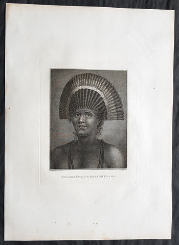
1784 Cook & Webber Large 1st Edition Antique Portrait of Poulaho King of Tonga
- Title : Poulaho, King of the Friendly Islands.
- Size: 21in x 15in (535mm x 385mm)
- Condition: (A+) Fine Condition
- Date : 1784
- Ref #: 82070
Description:
This large beautifully engraved original copper-plate 1st edition antique portrait of Fatafehi Paulaho, the Tui Tonga or Tongan King, visited by Captain Cook in 1777 by John Webber (Cooks official artist on the voyage) was published for the 1784 1st edition and official British Admiralty sanctioned account of Captain Cook’s third and final voyage along with that of Cooks successor Capt. James King......
A Voyage to the Pacific Ocean. Undertaken, by the Command of his Majesty, for making Discoveries in the Northern Hemisphere. To determine The Position and Extent of the West Side of North America; its Distance from Asia; and the Practicability of a Northern Passage to Europe. Performed under the direction of Captains Cook, Clerke, and Gore, In His Majesty\'s Ships the Resolution and Discovery. In the Years 1776, 1777, 1778, 1779, and 1780. In Three Volumes. Vol. I and II written by James Cook, F.R.S. Vol. III by Captain James King, LL.D. and F.R.S
Cooks diary ......On the 28th May 1777, as Cook was about to leave, Ha apai Paulaho came on board and brought me one of their Caps made or at least covered with red feathers. ..These Caps or rather bonnets are made of the tail feathers of the Tropic bird with red feathers of the Paroquets worked upon them or in along with them, they are made so as to tie upon the forehead without any Crown, and have the form of a Semicircle whose raids is 18 or 21 Inches. Cook Journals III, i.117.
Cook had described Paulaho as \\\'the corperate plump fellow we had met with\\\'.
......About Noon a large sailing Canoe came under our Stern in which the Indians on board told us was Fattafee Polaho [Fatafehi Paulaho] King of all the Isles. He brought with him as a present to me two good fat hogs, though not so fat as himself, for he was the most corperate plump fellow we had met with. I found him to be a Sedate sensible man… I asked him down into the Cabbin, some of his attendants objected to this, saying if he went there people would walk over his head and this was never done. I desired Omai to till them I would remove that objection by giving orders that no one should walk on that part of the deck but the chief \'waved the ceremony and walked down with me without any more to do.....
General Definitions:
Paper thickness and quality: - Heavy and stable
Paper color : - off white
Age of map color: -
Colors used: -
General color appearance: -
Paper size: - 21in x 15in (535mm x 385mm)
Plate size: - 21in x 15in (535mm x 385mm)
Margins: - Min 1/2in (12mm)
Imperfections:
Margins: - None
Plate area: - None
Verso: - None
Background:
Tonga officially the Kingdom of Tonga, is a Polynesian sovereign state and archipelago comprising 169 islands, of which 36 are inhabited. The total surface area is about 750 square kilometres (290 sq mi) scattered over 700,000 square kilometres (270,000 sq mi) of the southern Pacific Ocean. It has a population of 107,122 people, of whom 70% reside on the main island of Tongatapu.
The Tongan people first encountered Europeans in 1616 when the Dutch vessel Eendracht, captained by Willem Schouten, made a short visit to trade. Later came other Dutch explorers, including Jacob Le Maire (who called on the northern island of Niuatoputapu); and in 1643 Abel Tasman (who visited Tongatapu and Haapai).
Later noteworthy European visitors included James Cook (Royal Navy) in 1773, 1774, and 1777; Alessandro Malaspina (Spanish Navy) in 1793; the first London missionaries in 1797; and the Wesleyan Methodist Reverend Walter Lawry in 1822.
Tonga became known in the West as the Friendly Islands because of the congenial reception accorded to Captain James Cook on his first visit in 1773. He arrived at the time of the inasi festival, the yearly donation of the First Fruits to the Tui Tonga (the islands paramount chief) and so received an invitation to the festivities. According to the writer William Mariner, the chiefs wanted to kill Cook during the gathering but could not agree on a plan.
Captain James King FRS 1750 – 1784 was an officer of the Royal Navy. He served under James Cook on his last voyage around the world, specialising in taking important astronomical readings using a sextant. After Cook died he helped lead the ships on the remainder of their course, also completing Cooks account of the voyage. He continued his career in the Navy, reaching the rank of post-captain, commanding several ships and serving in the American War of Independence.
King joined HMS Resolution as second lieutenant, sharing the duties of astronomer with Cook, taking astronomical observations on board by sextant and with Larcum Kendals timekeeper K1, to establish the Resolutions position at sea and on shore by sextant or by astronomical quadrant to establish the geographical position of salient points during the course of Cooks surveys. Thus Kings geographical positions were an important contribution to the accuracy of the various surveys carried out during the voyage and his use of the early chronometers helped prove their use at sea for calculation of Longitude. .
Following the death of Cook, King remained in the Resolution but on the death of Charles Clerke, Cooks successor, King was appointed to command HMS Discovery, the Resolutions consort, remaining in her for the rest of the voyage. After his return to England King was very much involved in the publication of the official account of Cooks third voyage, writing the third volume at Woodstock, near Oxford, where his brother Thomas was rector of St Mary Magdalene. But shortly after his return King was promoted Post-captain and appointed commander of HMS Crocodile in the English Channel.
John Webber RA 1751 – 1793 was an English artist who accompanied Captain Cook on his third Pacific expedition. He is best known for his images of Australasia, Hawaii and Alaska.
Webber was born in London, educated in Bern and studied painting at Paris.His father was Abraham Wäber, a Swiss sculptor who had moved to London, and changed his name to Webber before marrying a Mrs Mary Quant in 1744.
Webber served as official artist on James Cooks third voyage of discovery around the Pacific (1776–80) aboard HMS Resolution. At Adventure Bay in January 1777 he did drawings of A Man of Van Diemens Land and A Woman of Van Diemens Land. He also did many drawings of scenes in New Zealand and the South Sea islands. On this voyage, during which Cook lost his life in a fight in Hawaii, Webber became the first European artist to make contact with Hawaii, then called the Sandwich Islands. He made numerous watercolor landscapes of the islands of Kauai and Hawaii, and also portrayed many of the Hawaiian people.
In April 1778, Captain Cooks ships Resolution and Discovery anchored at Ship Cove, now known as Nootka Sound, Vancouver Island, Canada to refit. The crew took observations and recorded encounters with the local people. Webber made watercolour landscapes including Resolution and Discovery in Ship Cove, 1778. His drawings and paintings were engraved for British Admiraltys account of the expedition, which was published in 1784.
Back in England in 1780 Webber exhibited around 50 works at Royal Academy exhibitions between 1784 and 1792, and was elected an associate of the Royal Academy in 1785 and R.A. in 1791. Most of his work were landscapes. Sometimes figures were included as in A Party from H.M.S. Resolution shooting sea horses, which was shown at the academy in 1784, and his The Death of Captain Cook became well known through an engraving of it. Another version of this picture is in the William Dixson gallery at Sydney
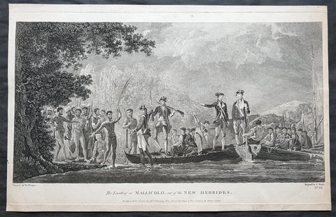
1777 Capt Cook Antique Print View of Cook Landing on Malakula Island, Vanuatu in 1774
- Title : The Landing at Mallicolo one of the New Hebrides...Published Feb 1st 1777 by Wm. Strahan
- Ref : 91223
- Size: 19in x 12 ½in (485mm x 320mm)
- Date : 1777
- Condition: (A) Very Good Condition
Description:
This fine original copper-plate engraved antique print of Captain James Cook & his men landing on the Island of Malakula (Mallicolo) in the Vanuatu group of Islands in the South Pacific, visited by Cook during his 2nd Voyage of Discovery to the South Seas in 1774, was engraved by James Basire - after William Hodges - and was published in Captain James Cooks 1777 edition of A voyage towards the South Pole, and round the World. Performed in His Majestys ships the Resolution and Adventure, in the years 1772, 1773, 1774, and 1775. printed by William Strahan, New Street, Shoe Lane, & Thos. Cadell, in the Strand, London 1777.
General Definitions:
Paper thickness and quality: - Heavy and stable
Paper color : - off white
Age of map color: -
Colors used: -
General color appearance: -
Paper size: - 19in x 12 ½in (485mm x 320mm)
Plate size: - 19in x 12in (480mm x 305mm)
Margins: - Min 1/2in (12mm)
Imperfections:
Margins: - None
Plate area: - Two very small worm holes
Verso: - None
Background:
Malakula Island also spelled Malekula, is the second-largest island in the nation of Vanuatu, in the Pacific Ocean region of Melanesia.
First discovered by the Spanish expedition of Pedro Fernández de Quirós in 1606 and visited by Captain James Cook in 1774.
Vanuatu officially the Republic of Vanuatu is a Pacific island nation located in the South Pacific Ocean. The archipelago, which is of volcanic origin, is 1,750 kilometres east of northern Australia, 540 kilometres northeast of New Caledonia, east of New Guinea, southeast of the Solomon Islands, and west of Fiji.
Vanuatu was first inhabited by Melanesian people. The first Europeans to visit the islands were a Spanish expedition led by Portuguese navigator Fernandes de Queirós, who arrived on the largest island in 1606. Since the Portuguese and Spanish monarchies had been unified under the king of Spain in 1580 (following the vacancy of the Portuguese throne, which lasted for sixty years, until 1640, when the Portuguese monarchy was restored), Queirós claimed the archipelago for Spain, as part of the colonial Spanish East Indies, and named it La Austrialia del Espiritu Santo.
The Vanuatu group of islands first had contact with Europeans in 1606, when the Portuguese explorer Pedro Fernandes de Queiros, sailing for the Spanish Crown, arrived on the largest island and called the group of islands La Austrialia del Espiritu Santo or The Southern Land of the Holy Spirit, believing he had arrived in Terra Australis or Australia. The Spanish established a short-lived settlement at Big Bay on the north side of the island. The name Espiritu Santo remains to this day.
Europeans did not return until 1768, when Louis Antoine de Bougainville rediscovered the islands on 22 May, naming them the Great Cyclades. In 1774, Captain Cook named the islands the New Hebrides, a name that would last until independence in 1980.
William Hodges RA 1744 – 1797 was an English painter. He was a member of James Cooks second voyage to the Pacific Ocean, and is best known for the sketches and paintings of locations he visited on that voyage, including Table Bay, Tahiti, Easter Island, and the Antarctic.
Between 1772 and 1775 Hodges accompanied James Cook to the Pacific as the expeditions artist. Many of his sketches and wash paintings were adapted as engravings in the original published edition of Cooks journals from the voyage.
Most of the large-scale landscape oil paintings from his Pacific travels for which Hodges is best known were finished after his return to London; he received a salary from the Admiralty for the purposes of completing them. These paintings depicted a stronger light and shadow than had been usual in European landscape tradition. Contemporary art critics complained that his use of light and colour contrasts gave his paintings a rough and unfinished appearance.
Hodges also produced many valuable portrait sketches of Pacific islanders and scenes from the voyage involving members of the expedition.
James Basire 1730–1802, also known as James Basire Sr., was an English engraver. He is the most significant of a family of engravers, and noted for his apprenticing of the young William Blake.
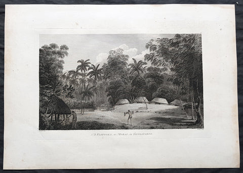
1784 Cook & Webber Large 1st Edition Antique Print Burial Mounds or Langi, Tonga
- Title : A Fiatooka or Morai in Tongataboo
- Size: 21in x 15in (535mm x 385mm)
- Condition: (A+) Fine Condition
- Date : 1784
- Ref #: 82068
Description:
This large beautifully engraved original copper-plate 1st edition antique print of the faitoka or the Royal Langi (burial mounds) in the village of Mua on the main Tongan Island of Tongatapu as seen by Captain James Cook in 1777 and John Webber (Cooks official artist on the voyage) was published for the 1784 1st edition and official British Admiralty sanctioned account of Captain Cook’s third and final voyage along with that of Cooks successor Capt. James King......
A Voyage to the Pacific Ocean. Undertaken, by the Command of his Majesty, for making Discoveries in the Northern Hemisphere. To determine The Position and Extent of the West Side of North America; its Distance from Asia; and the Practicability of a Northern Passage to Europe. Performed under the direction of Captains Cook, Clerke, and Gore, In His Majesty\'s Ships the Resolution and Discovery. In the Years 1776, 1777, 1778, 1779, and 1780. In Three Volumes. Vol. I and II written by James Cook, F.R.S. Vol. III by Captain James King, LL.D. and F.R.S
While on Tongatapu from 10 June to 10 July 1777, Cook and his men recorded Tongan ceremonies and culture. In this view Webber depicts a faitoka (burying ground).
Cooks journal ......\'The Places set apart for burying the dead are raised with Gravel about a foot or two above the level of the Ground, on which stand two or three Houses which are constantly shut up but contain nothing in them; these Ceremonies called in their Language Dano are kept very neat & clean & the Indians are generally despleased at our approaching them.....
General Definitions:
Paper thickness and quality: - Heavy and stable
Paper color : - off white
Age of map color: -
Colors used: -
General color appearance: -
Paper size: - 21in x 15in (535mm x 385mm)
Plate size: - 21in x 15in (535mm x 385mm)
Margins: - Min 1/2in (12mm)
Imperfections:
Margins: - Light soiling
Plate area: - None
Verso: - Light soiling
Background:
Tonga officially the Kingdom of Tonga, is a Polynesian sovereign state and archipelago comprising 169 islands, of which 36 are inhabited. The total surface area is about 750 square kilometres (290 sq mi) scattered over 700,000 square kilometres (270,000 sq mi) of the southern Pacific Ocean. It has a population of 107,122 people, of whom 70% reside on the main island of Tongatapu.
The Tongan people first encountered Europeans in 1616 when the Dutch vessel Eendracht, captained by Willem Schouten, made a short visit to trade. Later came other Dutch explorers, including Jacob Le Maire (who called on the northern island of Niuatoputapu); and in 1643 Abel Tasman (who visited Tongatapu and Haapai).
Later noteworthy European visitors included James Cook (Royal Navy) in 1773, 1774, and 1777; Alessandro Malaspina (Spanish Navy) in 1793; the first London missionaries in 1797; and the Wesleyan Methodist Reverend Walter Lawry in 1822.
Tonga became known in the West as the Friendly Islands because of the congenial reception accorded to Captain James Cook on his first visit in 1773. He arrived at the time of the inasi festival, the yearly donation of the First Fruits to the Tui Tonga (the islands paramount chief) and so received an invitation to the festivities. According to the writer William Mariner, the chiefs wanted to kill Cook during the gathering but could not agree on a plan.
Mu a is a small town in the Hahake (eastern) district on the island of Tongatapu, and it was for centuries the ancient capital of Tonga. It is divided in the villages Lapaha and Tatakamotonga, is close to Talasiu and famous for the ancient langi (royal burial tombs).
Mua was at one time the center of Lapita culture in Tonga (about 2,000 years ago) and later (twelfth to sixteenth century CE) the capital of the Tuʻi Tonga Empire. After the disintegration of the empire it remained the capital of the Tui Tonga (Tonga kings), up to the nineteenth century, but was rather a spiritual centre and no longer a source of political power.
The Tui Tonga and his retinue stayed in Lapaha, his residence being Olotele and Ahofakasiu, while Takuilau was for his wives. Subchiefs and servants on the other hand lived in Tatakamotonga.
When, around 1470, the Tui Tonga line started to lose power to the Tui Ha atakalaua, and another century later to the Tu i Kanokupolu, chiefs belonging to these lines were not welcome in Mu a, and had to stay on the low-lying coastal areas, separated from the real chiefs (i.e. those belonging to the Tu i Tonga) by the Hala Fonuamoa (dry land road). The former became known as the kauhalalalo (low road people) and the latter as the kauhala uta (inland road people), which nowadays are still two important moieties in Tonga.
Whatever political power the Tu i Tonga yielded to their rivals, they gained in spiritual power, and as a kind of high priest they were perhaps even more awesome than as kings. When a Tu i Tonga died he was buried in one of the huge tomb hills, known as langi, of which there are still at least two dozen in Lapaha. The Tu i Haʻatakalaua were also buried in such tombs, but they are called fale instead.
The langi are big, artificial hills surrounded by huge slabs of coral rock, usually in three or more tiered layers. These slabs were quarried from several places along the coast of Tongatapu or neighbouring minor islands. The waves of the sea made them over the centuries, by compacting coral sand into layers of 10 to 20 centimetres (3.9 to 7.9 inches) thick. They were only to be dug out and then transported by boat to the building site. Nevertheless, the accuracy by which the slabs were cut to shape so that they fit along each other with barely any space to spare is remarkable.
One of the best-preserved langi is the Paepae-o-Tele a, which is even more remarkable as the slabs along the corner really have an L shape.
The story that the slabs were moved by magic means from Uvea to Tonga is just a myth. Uvea is volcanic and has not got the proper geology. This fact has always been known, as shown, for example by a stanza of the poem named Laveofo from around the 18th century by Tufui.
Captain James King FRS 1750 – 1784 was an officer of the Royal Navy. He served under James Cook on his last voyage around the world, specialising in taking important astronomical readings using a sextant. After Cook died he helped lead the ships on the remainder of their course, also completing Cooks account of the voyage. He continued his career in the Navy, reaching the rank of post-captain, commanding several ships and serving in the American War of Independence.
King joined HMS Resolution as second lieutenant, sharing the duties of astronomer with Cook, taking astronomical observations on board by sextant and with Larcum Kendals timekeeper K1, to establish the Resolutions position at sea and on shore by sextant or by astronomical quadrant to establish the geographical position of salient points during the course of Cooks surveys. Thus Kings geographical positions were an important contribution to the accuracy of the various surveys carried out during the voyage and his use of the early chronometers helped prove their use at sea for calculation of Longitude. .
Following the death of Cook, King remained in the Resolution but on the death of Charles Clerke, Cooks successor, King was appointed to command HMS Discovery, the Resolutions consort, remaining in her for the rest of the voyage. After his return to England King was very much involved in the publication of the official account of Cooks third voyage, writing the third volume at Woodstock, near Oxford, where his brother Thomas was rector of St Mary Magdalene. But shortly after his return King was promoted Post-captain and appointed commander of HMS Crocodile in the English Channel.
John Webber RA 1751 – 1793 was an English artist who accompanied Captain Cook on his third Pacific expedition. He is best known for his images of Australasia, Hawaii and Alaska.
Webber was born in London, educated in Bern and studied painting at Paris.His father was Abraham Wäber, a Swiss sculptor who had moved to London, and changed his name to Webber before marrying a Mrs Mary Quant in 1744.
Webber served as official artist on James Cooks third voyage of discovery around the Pacific (1776–80) aboard HMS Resolution. At Adventure Bay in January 1777 he did drawings of A Man of Van Diemens Land and A Woman of Van Diemens Land. He also did many drawings of scenes in New Zealand and the South Sea islands. On this voyage, during which Cook lost his life in a fight in Hawaii, Webber became the first European artist to make contact with Hawaii, then called the Sandwich Islands. He made numerous watercolor landscapes of the islands of Kauai and Hawaii, and also portrayed many of the Hawaiian people.
In April 1778, Captain Cooks ships Resolution and Discovery anchored at Ship Cove, now known as Nootka Sound, Vancouver Island, Canada to refit. The crew took observations and recorded encounters with the local people. Webber made watercolour landscapes including Resolution and Discovery in Ship Cove, 1778. His drawings and paintings were engraved for British Admiraltys account of the expedition, which was published in 1784.
Back in England in 1780 Webber exhibited around 50 works at Royal Academy exhibitions between 1784 and 1792, and was elected an associate of the Royal Academy in 1785 and R.A. in 1791. Most of his work were landscapes. Sometimes figures were included as in A Party from H.M.S. Resolution shooting sea horses, which was shown at the academy in 1784, and his The Death of Captain Cook became well known through an engraving of it. Another version of this picture is in the William Dixson gallery at Sydney
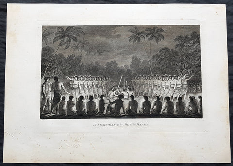
1784 Cook & Webber Large 1st Edition Antique Print Men Dancing Lifuka Isle Tonga
- Title : Night Dance by Men in Hapaee
- Size: 21in x 15in (535mm x 385mm)
- Condition: (A+) Fine Condition
- Date : 1784
- Ref #: 82066
Description:
This large beautifully engraved original copper-plate 1st edition antique print of Captain Cook (seen in the foreground) and his men watching men dancing at night on the Island of Lifuka, in the Ha apai island group of Tonga, at the time of Cooks visit in 1777 as drawn by John Webber (Cooks official artist on the voyage) was published for the 1784 1st edition and official British Admiralty sanctioned account of Captain Cook’s third and final voyage along with that of Cooks successor Capt. James King......
A Voyage to the Pacific Ocean. Undertaken, by the Command of his Majesty, for making Discoveries in the Northern Hemisphere. To determine The Position and Extent of the West Side of North America; its Distance from Asia; and the Practicability of a Northern Passage to Europe. Performed under the direction of Captains Cook, Clerke, and Gore, In His Majesty\'s Ships the Resolution and Discovery. In the Years 1776, 1777, 1778, 1779, and 1780. In Three Volumes. Vol. I and II written by James Cook, F.R.S. Vol. III by Captain James King, LL.D. and F.R.S
General Definitions:
Paper thickness and quality: - Heavy and stable
Paper color : - off white
Age of map color: -
Colors used: -
General color appearance: -
Paper size: - 21in x 15in (535mm x 385mm)
Plate size: - 21in x 15in (535mm x 385mm)
Margins: - Min 1/2in (12mm)
Imperfections:
Margins: - Light soiling
Plate area: - None
Verso: - Light soiling
Background:
Tonga officially the Kingdom of Tonga, is a Polynesian sovereign state and archipelago comprising 169 islands, of which 36 are inhabited. The total surface area is about 750 square kilometres (290 sq mi) scattered over 700,000 square kilometres (270,000 sq mi) of the southern Pacific Ocean. It has a population of 107,122 people, of whom 70% reside on the main island of Tongatapu.
The Tongan people first encountered Europeans in 1616 when the Dutch vessel Eendracht, captained by Willem Schouten, made a short visit to trade. Later came other Dutch explorers, including Jacob Le Maire (who called on the northern island of Niuatoputapu); and in 1643 Abel Tasman (who visited Tongatapu and Haapai).
Later noteworthy European visitors included James Cook (Royal Navy) in 1773, 1774, and 1777; Alessandro Malaspina (Spanish Navy) in 1793; the first London missionaries in 1797; and the Wesleyan Methodist Reverend Walter Lawry in 1822.
Tonga became known in the West as the Friendly Islands because of the congenial reception accorded to Captain James Cook on his first visit in 1773. He arrived at the time of the inasi festival, the yearly donation of the First Fruits to the Tui Tonga (the islands paramount chief) and so received an invitation to the festivities. According to the writer William Mariner, the chiefs wanted to kill Cook during the gathering but could not agree on a plan.
Lifuka is an island in the Kingdom of Tonga. It is located within the Ha apai Group in the centre of the country, to northeast of the national capital of Nuku alofa.
Lifuka is the place where Captain James Cook dubbed Tonga The Friendly Islands. Tofua is where the mutiny on the Bounty occurred in 1789; this active volcanic island lies approximately forty nautical miles west of Lifuka. The Cpt. Bligh voyage stands as the longest successful passage ever recorded in an open boat without modern navigational aids.
Captain James King FRS 1750 – 1784 was an officer of the Royal Navy. He served under James Cook on his last voyage around the world, specialising in taking important astronomical readings using a sextant. After Cook died he helped lead the ships on the remainder of their course, also completing Cooks account of the voyage. He continued his career in the Navy, reaching the rank of post-captain, commanding several ships and serving in the American War of Independence.
King joined HMS Resolution as second lieutenant, sharing the duties of astronomer with Cook, taking astronomical observations on board by sextant and with Larcum Kendals timekeeper K1, to establish the Resolutions position at sea and on shore by sextant or by astronomical quadrant to establish the geographical position of salient points during the course of Cooks surveys. Thus Kings geographical positions were an important contribution to the accuracy of the various surveys carried out during the voyage and his use of the early chronometers helped prove their use at sea for calculation of Longitude. .
Following the death of Cook, King remained in the Resolution but on the death of Charles Clerke, Cooks successor, King was appointed to command HMS Discovery, the Resolutions consort, remaining in her for the rest of the voyage. After his return to England King was very much involved in the publication of the official account of Cooks third voyage, writing the third volume at Woodstock, near Oxford, where his brother Thomas was rector of St Mary Magdalene. But shortly after his return King was promoted Post-captain and appointed commander of HMS Crocodile in the English Channel.
John Webber RA 1751 – 1793 was an English artist who accompanied Captain Cook on his third Pacific expedition. He is best known for his images of Australasia, Hawaii and Alaska.
Webber was born in London, educated in Bern and studied painting at Paris.His father was Abraham Wäber, a Swiss sculptor who had moved to London, and changed his name to Webber before marrying a Mrs Mary Quant in 1744.
Webber served as official artist on James Cooks third voyage of discovery around the Pacific (1776–80) aboard HMS Resolution. At Adventure Bay in January 1777 he did drawings of A Man of Van Diemens Land and A Woman of Van Diemens Land. He also did many drawings of scenes in New Zealand and the South Sea islands. On this voyage, during which Cook lost his life in a fight in Hawaii, Webber became the first European artist to make contact with Hawaii, then called the Sandwich Islands. He made numerous watercolor landscapes of the islands of Kauai and Hawaii, and also portrayed many of the Hawaiian people.
In April 1778, Captain Cooks ships Resolution and Discovery anchored at Ship Cove, now known as Nootka Sound, Vancouver Island, Canada to refit. The crew took observations and recorded encounters with the local people. Webber made watercolour landscapes including Resolution and Discovery in Ship Cove, 1778. His drawings and paintings were engraved for British Admiraltys account of the expedition, which was published in 1784.
Back in England in 1780 Webber exhibited around 50 works at Royal Academy exhibitions between 1784 and 1792, and was elected an associate of the Royal Academy in 1785 and R.A. in 1791. Most of his work were landscapes. Sometimes figures were included as in A Party from H.M.S. Resolution shooting sea horses, which was shown at the academy in 1784, and his The Death of Captain Cook became well known through an engraving of it. Another version of this picture is in the William Dixson gallery at Sydney
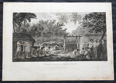
1784 Cook & Webber Large 1st Edition Antique Print of Human Sacrifice on Tahiti
- Title : A Human Sacrifice in a Morai, in Otaheite
- Size: 21in x 15in (535mm x 385mm)
- Condition: (A+) Fine Condition
- Date : 1784
- Ref #: 82063
Description:
This large beautifully engraved original copper-plate 1st edition antique print of Captain Cook (seen to the right) and his men witnessing a human sacrifice on a Maori (Marae) in Tahiti during Cooks visit in 1777 as drawn by John Webber (Cooks official artist on the voyage) was published for the 1784 1st edition and official British Admiralty sanctioned account of Captain Cook’s third and final voyage along with that of Cooks successor Capt. James King......
A Voyage to the Pacific Ocean. Undertaken, by the Command of his Majesty, for making Discoveries in the Northern Hemisphere. To determine The Position and Extent of the West Side of North America; its Distance from Asia; and the Practicability of a Northern Passage to Europe. Performed under the direction of Captains Cook, Clerke, and Gore, In His Majesty\'s Ships the Resolution and Discovery. In the Years 1776, 1777, 1778, 1779, and 1780. In Three Volumes. Vol. I and II written by James Cook, F.R.S. Vol. III by Captain James King, LL.D. and F.R.S
.......During his final visit, Cook returned Mai to Tahiti on 12 Aug. 1777, after Mais long visit in England. Cook also brought two Maori from Queen Charlotte Sound, Te Weherua and Koa. Cook first harbored in Vaitepiha Bay, where he visited Vehiatua II s funeral bier and the prefabricated Spanish mission house. Cook also met Vehiatua III, and inscribed on the back of the Spanish cross, Georgius tertius Rex Annis 1767, 69, 73, 74 & 77, as a counterpoint to Christus Vincit Carolus III imperat 1774 on the front. On 23 Aug., Cook sailed for Matavai Bay, where he met Tu, his father Teu, his mother Tetupaia, his brothers Ari ipaea and Vaetua, and his sisters Ari ipaea-vahine, Tetua-te-ahamai, and Auo. Cook also observed a human sacrifice, taata tapu, at the Utu-ai-mahurau marae, and 49 skulls from previous victims......
General Definitions:
Paper thickness and quality: - Heavy and stable
Paper color : - off white
Age of map color: -
Colors used: -
General color appearance: -
Paper size: - 21in x 15in (535mm x 385mm)
Plate size: - 21in x 15in (535mm x 385mm)
Margins: - Min 1/2in (12mm)
Imperfections:
Margins: - Light soiling
Plate area: - None
Verso: - Light soiling
Background:
Tahiti previously also known as Otaheite is the largest island in the Windward group of French Polynesia. The island is located in the archipelago of the Society Islands in the central Southern Pacific Ocean.
The first European to have visited Tahiti according to existing records was lieutenant Samuel Wallis, who was circumnavigating the globe in HMS Dolphin, sighting the island on 18 June 1767, and eventually harboring in Matavai Bay. This bay was situated on the territory of the chiefdom of Pare-Arue, governed by Tu (Tu-nui-e-a a-i-te-Atua) and his regent Tutaha, and the chiefdom of Ha apape, governed by Amo and his wife Oberea (Purea). Wallis named the island King Georges Island. The first contacts were difficult, since on the 24 and 26 June 1767, Tahitian warriors in canoes showed aggression towards the British, hurling stones from their slings. In retaliation, the British sailors opened fire on the warriors in the canoes and on the hills. In reaction to this powerful counter-attack, the Tahitians laid down peace offerings for the British. Following this episode, Samuel Wallis was able to establish cordial relations with the female chieftain “Oberea “ (Purea) and remained on the island until 27 July 1767.
In July 1768, Captain James Cook was commissioned by the Royal Society and on orders from the Lords Commissioners of the Admiralty to observe the transit of Venus across the sun, a phenomenon that would be visible from Tahiti on 3 June 1769. He arrived in Tahitis Matavai Bay, commanding the HMS Endeavour on 12 April 1769. On 14 April, Cook met with Tutaha and Tepau. On 15 April, Cook picked the site for a fortified camp at Point Venus along with Banks, Parkinson, Daniel Solander, to protect Charles Greens observatory. The length of stay enabled them to undertake for the first time real ethnographic and scientific observations of the island. Assisted by the botanist Joseph Banks, and by the artist Sydney Parkinson, Cook gathered valuable information on the fauna and flora, as well as the native society, language and customs, including the proper name of the island, Otaheite. On 28 April, Cook met Purea and Tupaia, and Tupaia befriended Banks following the transit. On 21 June, Amo visited Cook, and then on 25 June, Pohuetea visited, signifying another chief seeking to ally himself with the British.
Cook and Banks circumnavigated the island from 26 June to 1 July. On the exploration, they met Ahio, chief of Ha apaiano o or Papenoo, Rita, chief of Hitia a, Pahairro, chief of Pueu, Vehiatua, chief of Tautra, Matahiapo, chief of Teahupo o, Tutea, chief of Vaira o, and Moe, chief of Afa Ahiti. In Papara, guided by Tupaia, they investigated the ruins of Mahaiatea marae, an impressive structure containing a stone pyramid or ahu, measuring 44 feet high, 267 feet long and 87 feet wide. Cook and the Endeavour departed Tahiti on 13 July 1769, taking Raiatean navigator Tupaia along for his geographic knowledge of the islands.
Cook returned to Tahiti between 15 August and 1 September 1773, greeted by the chiefs Tai and Puhi, besides the youg ari i Vehiatua II and his stepfather Ti itorea. Cook anchored in Vaitepiha Bay before returning to Point Venus where he met Tu, the paramount chief. Cook picked up two passengers from Tahiti during this trip, Porea and Mai, with Hitihiti later replacing Porea when Cook stopped at Raiatea. Cook took Hitihiti to Tahiti on 22 April, during his return leg. Then, Cook departed Tahiti on 14 May 1774.
During his final visit, Cook returned Mai to Tahiti on 12 Aug. 1777, after Mais long visit in England. Cook also brought two Maori from Queen Charlotte Sound, Te Weherua and Koa. Cook first harbored in Vaitepiha Bay, where he visited Vehiatua II s funeral bier and the prefabricated Spanish mission house. Cook also met Vehiatua III, and inscribed on the back of the Spanish cross, Georgius tertius Rex Annis 1767, 69, 73, 74 & 77, as a counterpoint to Christus Vincit Carolus III imperat 1774 on the front. On 23 Aug., Cook sailed for Matavai Bay, where he met Tu, his father Teu, his mother Tetupaia, his brothers Ari ipaea and Vaetua, and his sisters Ari ipaea-vahine, Tetua-te-ahamai, and Auo. Cook also observed a human sacrifice, taata tapu, at the Utu-ai-mahurau marae, and 49 skulls from previous victims.
On 29 Sept. 1777, Cook sailed for Papetoai Bay on Moorea. Cook met Mahine in an act of friendship on 3 Oct., though he was an enemy of Tu. When a goat kid was stolen on 6 Oct., Cook in a rampage, ordered the burning of houses and canoes until it was returned. Cook sailed for Huahine on 11 Oct., Raiatea on 2 Nov., and Borabora on 7 Dec.
On 26 October 1788, HMS Bounty, under the command of Captain William Bligh, landed in Tahiti with the mission of carrying Tahitian breadfruit trees (Tahitian: uru) to the Caribbean. Sir Joseph Banks, the botanist from James Cooks first expedition, had concluded that this plant would be ideal to feed the African slaves working in the Caribbean plantations at very little cost. The crew remained in Tahiti for about five months, the time needed to transplant the seedlings of the trees. Three weeks after leaving Tahiti, on 28 April 1789, the crew mutinied on the initiative of Fletcher Christian. The mutineers seized the ship and set the captain and most of those members of the crew who remained loyal to him adrift in a ships boat. A group of mutineers then went back to settle in Tahiti.
Although various explorers had refused to get involved in tribal conflicts, the mutineers from the Bounty offered their services as mercenaries and furnished arms to the family which became the Pōmare Dynasty. The chief Tū knew how to use their presence in the harbours favoured by sailors to his advantage. As a result of his alliance with the mutineers, he succeeded in considerably increasing his supremacy over the island of Tahiti.
Captain James King FRS 1750 – 1784 was an officer of the Royal Navy. He served under James Cook on his last voyage around the world, specialising in taking important astronomical readings using a sextant. After Cook died he helped lead the ships on the remainder of their course, also completing Cooks account of the voyage. He continued his career in the Navy, reaching the rank of post-captain, commanding several ships and serving in the American War of Independence.
King joined HMS Resolution as second lieutenant, sharing the duties of astronomer with Cook, taking astronomical observations on board by sextant and with Larcum Kendals timekeeper K1, to establish the Resolutions position at sea and on shore by sextant or by astronomical quadrant to establish the geographical position of salient points during the course of Cooks surveys. Thus Kings geographical positions were an important contribution to the accuracy of the various surveys carried out during the voyage and his use of the early chronometers helped prove their use at sea for calculation of Longitude. .
Following the death of Cook, King remained in the Resolution but on the death of Charles Clerke, Cooks successor, King was appointed to command HMS Discovery, the Resolutions consort, remaining in her for the rest of the voyage. After his return to England King was very much involved in the publication of the official account of Cooks third voyage, writing the third volume at Woodstock, near Oxford, where his brother Thomas was rector of St Mary Magdalene. But shortly after his return King was promoted Post-captain and appointed commander of HMS Crocodile in the English Channel.
John Webber RA 1751 – 1793 was an English artist who accompanied Captain Cook on his third Pacific expedition. He is best known for his images of Australasia, Hawaii and Alaska.
Webber was born in London, educated in Bern and studied painting at Paris.His father was Abraham Wäber, a Swiss sculptor who had moved to London, and changed his name to Webber before marrying a Mrs Mary Quant in 1744.
Webber served as official artist on James Cooks third voyage of discovery around the Pacific (1776–80) aboard HMS Resolution. At Adventure Bay in January 1777 he did drawings of A Man of Van Diemens Land and A Woman of Van Diemens Land. He also did many drawings of scenes in New Zealand and the South Sea islands. On this voyage, during which Cook lost his life in a fight in Hawaii, Webber became the first European artist to make contact with Hawaii, then called the Sandwich Islands. He made numerous watercolor landscapes of the islands of Kauai and Hawaii, and also portrayed many of the Hawaiian people.
In April 1778, Captain Cooks ships Resolution and Discovery anchored at Ship Cove, now known as Nootka Sound, Vancouver Island, Canada to refit. The crew took observations and recorded encounters with the local people. Webber made watercolour landscapes including Resolution and Discovery in Ship Cove, 1778. His drawings and paintings were engraved for British Admiraltys account of the expedition, which was published in 1784.
Back in England in 1780 Webber exhibited around 50 works at Royal Academy exhibitions between 1784 and 1792, and was elected an associate of the Royal Academy in 1785 and R.A. in 1791. Most of his work were landscapes. Sometimes figures were included as in A Party from H.M.S. Resolution shooting sea horses, which was shown at the academy in 1784, and his The Death of Captain Cook became well known through an engraving of it. Another version of this picture is in the William Dixson gallery at Sydney
1836 Dumont D Urville Large Antique Print Monument to La Perouse Solomon Islands
- Title : Inauguration du Monument
- Size: 19 1/2in x 13 1/2in (495mm x 345mm)
- Condition: (B) Good Condition
- Date : 1836
- Ref #: 31734-1
Description:
This large original antique lithograph print of Dumont D Urville Inauguration of a monument to Jean François de Galaup, comte de Lapérouse on the island of Vanikoro, part of the Solomon Islands in the south Pacific (the last resting place of La Perouse & his crew), by Louis Auguste de Sainson, the artist on the Astrolabe, during the first of Dumont D Urvilles first voyage to the South Seas between 1826 - 1829, was engraved by Antoine Maurin 1793 - 1860 and published in the 1836 1st edition of Dumont d Urvilles Voyage de la corvette L Astrolabe: exécuté par ordre du roi, pendant les années 1826-1827-1828-1829......
Louis Auguste de Sainson, (1800-1848). Sainson was a French draftsman & artist who specialized in natural history and geography. He accompanied the expedition of the corvette L Astrolabe as a naturalist directed by Jules Dumont d\\\'Urville between 1826-1829.
He began his naval career in a secretarial position at the French Atlantic port of Rochefort, working there from 1825 till 1826. He then volunteered to join the Astrolabe as a draughtsman, after being recommended to the expedition by Quoy, one of the naturalists on the expedition, joining the ship at Toulon on 7 February 1826.
He was responsible for the bulk of the drawings produced during the expedition, with over 500 in three years. Many of his drawings paintings and prints now reside in Australian, New Zealand & French museums.
General Definitions:
Paper thickness and quality: - Heavy and stable
Paper color : - off white
Age of map color: -
Colors used: -
General color appearance: -
Paper size: - 19 1/2in x 13 1/2in (495mm x 345mm)
Plate size: - 19 1/2in x 13 1/2in (495mm x 345mm)
Margins: - Min 1/2in (12mm)
Imperfections:
Margins: - Re-join to bottom margin
Plate area: - 9in & 2in re-join to bottom to centre of image
Verso: - Repair as noted, light spotting
Background:
Jean François de Galaup, comte de Lapérouse (1741 – 1788) was a French Naval officer and explorer whose expedition vanished in Oceania.
Lapérouse was appointed in 1785 by Louis XVI and by the Secretary of State of the Navy, the Marquis de Castries, to lead an expedition around the world. Many countries were initiating voyages of scientific explorations at that time.
The expeditions aims were to complete the Pacific discoveries of James Cook (whom Lapérouse greatly admired), correct and complete maps of the area, establish trade contacts, open new maritime routes and enrich French science and scientific collections. His ships were LAstrolabe (under Fleuriot de Langle) and La Boussole, both 500 tons. They were storeships reclassified as frigates for the occasion. Their objectives were geographic, scientific, ethnological, economic (looking for opportunities for whaling or fur trading), and political (the eventual establishment of French bases or colonial cooperation with their Spanish allies in the Philippines). They were to explore both the north and south Pacific, including the coasts of the Far East and of Australia, and send back reports through existing European outposts in the Pacific.
La Perouse visited Australia, arriving off Botany Bay on 24 January 1788. There Lapérouse encountered a British convoy (known later as the First Fleet) led by Captain Arthur Phillip RN, who was to establish the penal colony of New South Wales. While it had been intended that the colony would be located at Botany Bay, Phillip had quickly decided that the site was unsuitable and the colony would instead be established at Sydney Cove in Port Jackson. High winds – which had hindered Lapérouses ships in entering Botany Bay – delayed the relocation until 26 January (later commemorated as Australia Day).
The French were received courteously and spent six weeks at the British colony (their last recorded landfall). While Lapérouse and Phillip did not meet, French and British officers visited each other formally on at least 11 occasions, and offered each other assistance and supplies. During their stay, the French established an observatory and a garden, held masses, and made geological observations. Lapérouse also took the opportunity to send journals, charts and letters back to Europe, with the British merchant ship Alexander. The chaplain from L Astrolabe, Father Louis Receveur, never recovered from injuries he had sustained in a clash with indigenous people in the Samoan Islands and died at Botany Bay on 17 February; Receveur was buried on shore at Frenchmans Cove.
On 10 March, after taking on sufficient wood and fresh water, the French expedition left New South Wales – bound for New Caledonia, Santa Cruz, the Solomons, the Louisiades, and the western and southern coasts of Australia. While Lapérouse had reported in a letter from Port Jackson that he expected to be back in France by June 1789, neither he nor any members of his expedition were seen again by Europeans.
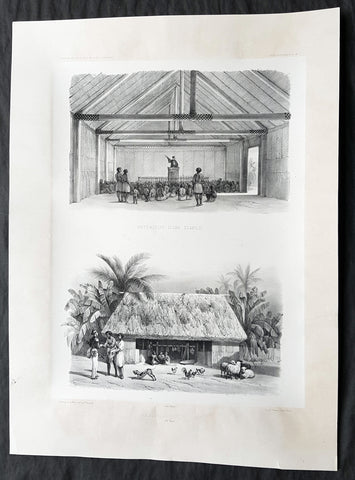
1842 D Urville & Le Breton Antique Print Church & Chief Tupou I Hut Vavau, Tonga
- Title : Interieur D un Temple: Habitation D un Chef (Isle Vavao)
- Size: 21in x 15in (535mm x 380mm)
- Condition: (A+) Fine Good Condition
- Date : 1842
- Ref #: 31750
Description:
This magnificent, large original antique lithograph print of the interior of the Protestant Church & Chief George Tupou I Hut both on the Tongan Island of Vavau , visited in October 1838 by Dumont D Urville in the ship The Astrolabe, was drawn by Louis Le Breton, asst. surgeon & artist/draftsman aboard the Astrolabe, during D Urvilles second voyage to the South Seas between 1837 - 1840, was engraved by Pharamond Blanchard and was published in the 1842 1st edition of Dumont d Urvilles Voyage au Pole Sud et dans l Océanie sur les corvettes l Astrolabe et la Zélée : Exécuté par ordre du roi pendant les années 1837-1838-1839-1840.
These large magnificent lithographs from the 1st edition are extremely hard to find, most only found in museums or in private hands, and due to the artistry are a must for any collection.
Louis Le Breton 1818 – 1866 was a French painter who specialised in marine paintings.
Le Breton studied medicine and took part in Dumont d Urville\'s second voyage aboard the Astrolabe. After the official illustrator of the expedition, Goupil, died, Le Breton replaced him.
From 1847 he devoted himself mainly to depicting marine subjects for the French Navy.
General Definitions:
Paper thickness and quality: - Heavy and stable
Paper color : - off white
Age of map color: -
Colors used: -
General color appearance: -
Paper size: - 21in x 15in (535mm x 380mm)
Plate size: - 21in x 15in (535mm x 380mm)
Margins: - Min 2in (50mm)
Imperfections:
Margins: - None
Plate area: - None
Verso: - None
Background:
Vavau is the island group of one large island (Utu Vavau) and 40 smaller ones in Tonga. It is part of Vavau District which includes several other individual islands. According to tradition the Maui god fished up both Tongatapu and Vavau but put a little more effort into the former. Vavau rises 204 metres (669 ft) above sea level at Mount Talau. The capital is Neiafu, which is the fifth largest city in Tonga, situated at the Port of Refuge (Puatalefusi or Lolo-a-Halaevalu).
Don Francisco Mourelle de la Rúa, commanding Spanish frigate Princesa was the first European to come to Vavau, on 4 March 1781. He charted Vavau as Martín de Mayorga who was the Viceroy of New Spain at the time. Captain James Cook knew about the islands a decade before, but the people in Haapai told him it would be no good for him to go there as there was no harbour. Apparently they did not want him to go there, and Cook heeded their advice anyway.
But Mourelle found excellent anchoring, of which he was in desperate need after having failed on Fonualei (Bitterness island) and Late, and he gave the spot the name Port of Refuge. But his original Port of Refuge was the bay on the west coast of the main island, near Longomapu. In 1793 Alessandro Malaspina visited for a month, following up on Mourelle and claiming the islands for Spain.
Tuʻi Tonga George Tupou I instituted the Vavau Code in Vavaʻu in 1839.
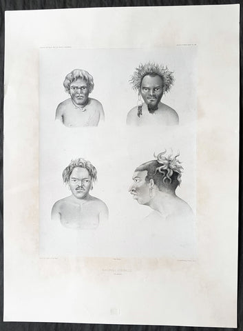
1842 D Urville & Goupil Antique Print of Men of Santa Isabel Isle, Solomon Isle.
- Title : Naturels D Isabelle (Isle Solomon)
- Size: 21in x 15in (535mm x 380mm)
- Condition: (A+) Fine Good Condition
- Date : 1842
- Ref #: 31745
Description:
This magnificent, large original antique lithograph print of profiles of 4 different men of the island of Santa Isabel of the Solomon Islands, visited in November & December 1838 by Dumont D Urville, drawn by Ernest Goupil, artist/draftsman aboard the Astrolabe during D Urvilles second voyage to the South Seas between 1837 - 1840, was engraved by Adolphe Jean-Baptiste Bayoti and was published in the 1842 1st edition of Dumont d Urvilles Voyage au Pole Sud et dans l Océanie sur les corvettes l Astrolabe et la Zélée : Exécuté par ordre du roi pendant les années 1837-1838-1839-1840.
These large magnificent lithographs from the 1st edition are extremely hard to find, most only found in museums or in private hands, and due to the artistry are a must for any collection.
Ernest Goupil was a French painter, draftsman and watercolourist He is known for the illustrations made as official painter for Dumont D Urvilles 2nd Voyage to the South Seas. In Voyage to the South Pole and in Oceania on corvettes l\'Astrobale and Zélée, executed by order of the king during the years 1837-1838-1839-1840, his drawings are transposed on stone, most notably by Emile Lassalle , Pharamond Blanchard and Adolphe Jean-Baptiste Bayot . Dumont d\'Urville relates: On the Zélée , Mr. Goupil fills his cartons with precious paintings, and on the Astrolabe , the young surgeon Le Breton, who has a remarkable talent in this genre, also performs at my asks for charming drawings.
Some drawings were sent to the Minister of the Navy and were shown to the King, who wanted to see them transposed into painting by the marine painter Théodore Gudin , but Goupil would not have given his consent.
In August 1839 in Samarang Java , the crew is struck by a violent epidemic, and after two months of suffering, Ernest Goupil succumbs and died on January 1 , 1840 ijn Hobart-town where he was buried with full military honours.
General Definitions:
Paper thickness and quality: - Heavy and stable
Paper color : - off white
Age of map color: -
Colors used: -
General color appearance: -
Paper size: - 21in x 15in (530mm x 380mm)
Plate size: - 21in x 15in (530mm x 380mm)
Margins: - Min 2in (50mm)
Imperfections:
Margins: - Light age toning
Plate area: - None
Verso: - None
Background:
Santa Isabel Island (also known as Isabel, Ysabel and Mahaga) is the longest in the Solomon Islands, the third largest in terms of surface area, and the largest in the group of islands in Isabel Province.
The first European contact to the Solomon Islands was made at Santa Isabel Island, by the Spanish explorer Álvaro de Mendaña on 7 February 1568. It was charted as Santa Isabel de la Estrella (St. Elizabeth of the Star of Bethlehem in Spanish). A settlement was established by the Spaniards, and a small boat (known in the accounts as the brigantine) was built to survey and chart the surrounding sea and islands. These local explorations led by Maestre de Campo Pedro Ortega Valencia and Alférez Hernando Enríquez resulted in the discoveries of the islands of Malaita, Guadalcanal, Savo, Vangunu, Choiseul, Makira, Ulawa, Malaupaina, Malaulalo, Ali\'ite, and Ugi Island. The Spanish immediately came into contact with Solomon Islanders and at first the relationship was cordial. However, the Spanish expedition\'s need for fresh food and water quickly led to tension and conflict, the Solomon Islanders’ subsistence economy being unable to provide continuous supplies to the Spanish.
Having found no gold and little food, and beset by attacks and sickness, the Spanish colonists shifted their colony to the site of today\'s Honiara on Guadalcanal, and the settlement on Santa Isabel was abandoned.
Santa Isabel islanders suffered attacks from blackbirding in the nineteenth century (the often brutal recruitment or kidnapping of labourers for the sugar plantations in Queensland and Fiji).
In April 1885 a German Protectorate was declared over the North Solomon Islands, including Santa Isabel Island. In 1900, under the terms of Treaty of Berlin (14 November 1899), Germany transferred the North Solomon Islands (except for Bougainville and its surrounding islands) to the British Solomon Islands Protectorate in exchange for the British giving up all claims to Samoa. Missionaries settled on Santa Isabel Island under both protectorates, converting most of the population to Christianity. In the early 20th century several British and Australian firms began large-scale coconut planting.
C1842 D Urville & Goupil Antique Print Chief Pea, Daughter & Wife of Apia, Samoa
- Title : Chef D Apia (Ise Opoulou): Jeune Fille D Apia (Ile Opoulou): Femme De Lefouga (Iles Hapai)
- Size: 22in x 14in (560mm x 370mm)
- Condition: (A+) Fine Good Condition
- Date : 1842
- Ref #: 31754
Description:
This magnificent, large original antique lithograph print of Pea the High Chief of the village of Apia on the Island of Upolu, Samoa along with and his daughter & wife visited in September 1838 by Dumont D Urville, by Ernest Goupil, the senior artist/draftsman aboard the Astrolabe, during D Urvilles second voyage to the South Seas between 1837 - 1840, was engraved by Adolphe Jean-Baptiste Bayotiand was published in the 1842 1st edition of Dumont d Urvilles Voyage au Pole Sud et dans l Océanie sur les corvettes l Astrolabe et la Zélée : Exécuté par ordre du roi pendant les années 1837-1838-1839-1840.
These large magnificent lithographs from the 1st edition are extremely hard to find, most only found in museums or in private hands, and due to the artistry are a must for any collection.
Ernest Goupil was a French painter, draftsman and watercolourist He is known for the illustrations made as official painter for Dumont D Urvilles 2nd Voyage to the South Seas. In Voyage to the South Pole and in Oceania on corvettes l\'Astrobale and Zélée, executed by order of the king during the years 1837-1838-1839-1840, his drawings are transposed on stone, most notably by Emile Lassalle , Pharamond Blanchard and Adolphe Jean-Baptiste Bayot . Dumont d\'Urville relates: On the Zélée , Mr. Goupil fills his cartons with precious paintings, and on the Astrolabe , the young surgeon Le Breton, who has a remarkable talent in this genre, also performs at my asks for charming drawings.
Some drawings were sent to the Minister of the Navy and were shown to the King, who wanted to see them transposed into painting by the marine painter Théodore Gudin , but Goupil would not have given his consent.
In August 1839 in Samarang Java , the crew is struck by a violent epidemic, and after two months of suffering, Ernest Goupil succumbs and died on January 1 , 1840 ijn Hobart-town where he was buried with full military honours.
General Definitions:
Paper thickness and quality: - Heavy and stable
Paper color : - off white
Age of map color: -
Colors used: -
General color appearance: -
Paper size: - 22in x 14in (560mm x 370mm)
Plate size: - 22in x 14in (560mm x 370mm)
Margins: - Min 2in (50mm)
Imperfections:
Margins: - None
Plate area: - None
Verso: - None
Background:
Apia is the capital and the largest city of Samoa. From 1900 to 1919, it was the capital of German Samoa. The city is located on the central north coast of Upolu, Samoa\'s second largest island. Apia is the only city in Samoa and falls within the political district (itūmālō) of Tuamasaga.
Apia was originally a small village from which the country\'s capital took its name. Apia village still exists within the larger modern capital of Apia which has grown into a sprawling urban area with many villages. Like every other settlement in the country, Apia village has its own matai chiefly leaders and fa\'alupega (genealogy and customary greetings) according to fa a Samoa.
The modern capital Apia was founded in the 1850s and has been the official capital of Samoa since 1959.
The harbor was also the site of an infamous 15 March 1889 naval standoff in which seven ships from Germany, the US, and Britain refused to leave harbor while a typhoon was clearly approaching, lest the first moved would lose face. All the ships were sunk, except the British cruiser Calliope, which barely managed to leave port at 1 mile per hour and ride out the storm. Nearly 200 American and German lives were lost, as well as six ships sunk or damaged beyond repair.
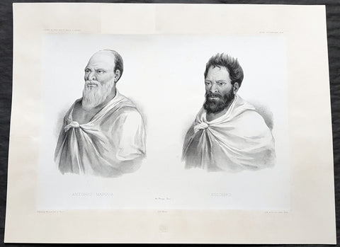
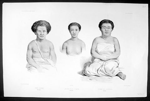
1842 D Urville & Marescot Antique Print King Mapou-Teoa & Envoy of Mangareva Gambier
- Title : Antonio Mapoua; Koloupo (Isles Manga Reva)
- Size: 21in x 15in (535mm x 380mm)
- Condition: (A+) Fine Good Condition
- Date : 1842
- Ref #: 31747
Description:
This large, magnificent, original antique lithograph print of King Mapou-Teoa and his envoy who boarded D Urvilles ship the Astrolabe in August 1838, by Jacques Marescot-Duthilleul, one of the artists,draftsman aboard the Astrolabe, during D Urvilles second voyage to the South Seas between 1837 - 1840, was engraved by Adolphe Jean-Baptiste Bayot and published in the 1842 1st edition of Dumont d UrvillesVoyage au Pole Sud et dans l Océanie sur les corvettes l Astrolabe et la Zélée : Exécuté par ordre du roi pendant les années 1837-1838-1839-1840.
These large magnificent lithographs from the 1st edition are extremely hard to find, most only found in museums or in private hands, and due to the artistry are a must for any collection.
Jacques, Marie, Eugene Marescot Duthilleul1809 - 1839 Lieutenant in the French navy and artist who accompanied Dumont D Urville on the Corvette The Astrolabe on D Urvilles 2nd Voyage to the South Seas, Australia and Antarctica between 1837 and 1840. He was responsible for a number of exquisite drawings of peoples and views during the voyage that were later used for lithograph prints for publication
In 1837, a new mission of exploration in the southern Pacific Ocean was entrusted by King Louis-Philippe to Captain Dumont d Urville. This mission included improvement of scientific knowledge on the islands of the South Pacific and Indonesia, and exploration of the Antarctic continent.
The first phase of the expedition was the crossing the Sea of Weddel sea ice, on the coast of the Antarctic Ice Sheet. The second phase between May 1838 &o December 1839 consisting of visits to many South Pacific Islands: Marquesas, Polynesia, Fiji, Solomon Islands, New Guinea, Carolinas, Marianas, Moluccas and finally Sunda Islands.
At the end of this second phase, after eighteen months of difficult navigation in unhealthy climates, the sanitary condition of the crews of the two corvettes reached a critical state. During the last voyage from Sumatra (Lampang Bay) to Hobart Tasmania, eighteen patients died, including Lieutenant Marescot-Duthilleul.
General Definitions:
Paper thickness and quality: - Heavy and stable
Paper color : - off white
Age of map color: -
Colors used: -
General color appearance: -
Paper size: - 21in x 15in (535mm x 380mm)
Plate size: - 21in x 15in (535mm x 380mm)
Margins: - Min 2in (50mm)
Imperfections:
Margins: - Repair to top margin, no loss
Plate area: - None
Verso: - None
Background:
Mangareva is the central and largest island of the Gambier Islands in French Polynesia. It is surrounded by smaller islands: Taravai in the southwest, Aukena and Akamaru in the southeast, and islands in the north.
Mangareva was once heavily forested and supported a large population that traded with other islands via canoes. However, excessive logging by the islanders during the 10th to the 15th centuries resulted in deforestation of the island, with disastrous results for its environment and economy.
The first European to arrive at Mangareva was British Captain James Wilson in 1797 on the ship Duff. Wilson named the island group in honour of Admiral James Gambier, who had helped him to equip his vessel.
Mangareva along with its dependencies in the Gambier Islands were ruled by a line of kings and later regents that ruled until the French formally annexed the islands in 1881. A French protectorate was requested on 16 February 1844 by King Maputeoa but was never ratified by the French government. On 4 February 1870, Prince Regent Arone Teikatoara and the Mangarevan government formally withdrew the protectorate request and asked the French to not intervene in the kingdom\'s affairs. After Father Honoré Laval was removed to Tahiti, the native government changed its stance and an agreement between Prince Regent Arone and the French colonial authority in Tahiti was signed reaffirming the protectorate status on 30 November 1871. The Gambier Islands were finally annexed on 21 February 1881 under Prince Regent Bernardo Putairi and approved by the President of France on 30 January 1882.
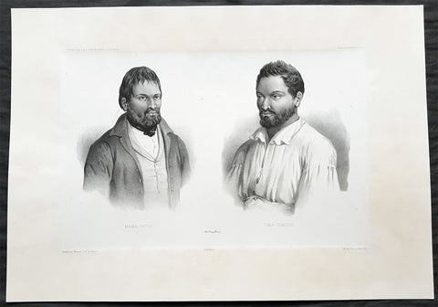
1842 D Urville & Marescot Antique Print of Envoys of Mangareva Isle, Gambier Is.
- Title : Mama-Houi; Tima-Temouo (Isles Maga Reva)
- Size: 21in x 15in (535mm x 380mm)
- Condition: (A+) Fine Good Condition
- Date : 1842
- Ref #: 31746
Description:
This large, magnificent, original antique lithograph print of Envoys of Mangreva Island, Gambier Island visited by Dumont D Urvilles & his ship the Astrolabe in August 1838, by Jacques Marescot-Duthilleul, one of the artists,draftsman aboard the Astrolabe, during D Urvilles second voyage to the South Seas between 1837 - 1840, was engraved by Adolphe Jean-Baptiste Bayot and published in the 1842 1st edition of Dumont d UrvillesVoyage au Pole Sud et dans l Océanie sur les corvettes l Astrolabe et la Zélée : Exécuté par ordre du roi pendant les années 1837-1838-1839-1840.
These large magnificent lithographs from the 1st edition are extremely hard to find, most only found in museums or in private hands, and due to the artistry are a must for any collection.
Jacques, Marie, Eugene Marescot Duthilleul1809 - 1839 Lieutenant in the French navy and artist who accompanied Dumont D Urville on the Corvette The Astrolabe on D Urvilles 2nd Voyage to the South Seas, Australia and Antarctica between 1837 and 1840. He was responsible for a number of exquisite drawings of peoples and views during the voyage that were later used for lithograph prints for publication
In 1837, a new mission of exploration in the southern Pacific Ocean was entrusted by King Louis-Philippe to Captain Dumont d Urville. This mission included improvement of scientific knowledge on the islands of the South Pacific and Indonesia, and exploration of the Antarctic continent.
The first phase of the expedition was the crossing the Sea of Weddel sea ice, on the coast of the Antarctic Ice Sheet. The second phase between May 1838 &o December 1839 consisting of visits to many South Pacific Islands: Marquesas, Polynesia, Fiji, Solomon Islands, New Guinea, Carolinas, Marianas, Moluccas and finally Sunda Islands.
At the end of this second phase, after eighteen months of difficult navigation in unhealthy climates, the sanitary condition of the crews of the two corvettes reached a critical state. During the last voyage from Sumatra (Lampang Bay) to Hobart Tasmania, eighteen patients died, including Lieutenant Marescot-Duthilleul.
General Definitions:
Paper thickness and quality: - Heavy and stable
Paper color : - off white
Age of map color: -
Colors used: -
General color appearance: -
Paper size: - 21in x 15in (535mm x 380mm)
Plate size: - 21in x 15in (535mm x 380mm)
Margins: - Min 2in (50mm)
Imperfections:
Margins: - None
Plate area: - None
Verso: - None
Background:
Mangareva is the central and largest island of the Gambier Islands in French Polynesia. It is surrounded by smaller islands: Taravai in the southwest, Aukena and Akamaru in the southeast, and islands in the north.
Mangareva was once heavily forested and supported a large population that traded with other islands via canoes. However, excessive logging by the islanders during the 10th to the 15th centuries resulted in deforestation of the island, with disastrous results for its environment and economy.
The first European to arrive at Mangareva was British Captain James Wilson in 1797 on the ship Duff. Wilson named the island group in honour of Admiral James Gambier, who had helped him to equip his vessel.
Mangareva along with its dependencies in the Gambier Islands were ruled by a line of kings and later regents that ruled until the French formally annexed the islands in 1881. A French protectorate was requested on 16 February 1844 by King Maputeoa but was never ratified by the French government. On 4 February 1870, Prince Regent Arone Teikatoara and the Mangarevan government formally withdrew the protectorate request and asked the French to not intervene in the kingdom\'s affairs. After Father Honoré Laval was removed to Tahiti, the native government changed its stance and an agreement between Prince Regent Arone and the French colonial authority in Tahiti was signed reaffirming the protectorate status on 30 November 1871. The Gambier Islands were finally annexed on 21 February 1881 under Prince Regent Bernardo Putairi and approved by the President of France on 30 January 1882.
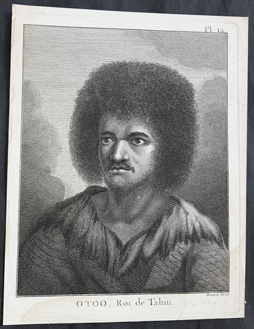
1774 Capt. Cook Antique Print a Portrait of Chief Tynah, Otoo of Tahiti in 1769
- Title : Otoo, Roi de Tahiti
- Ref : 31771
- Size: 10in x 8in (255mm x 205mm)
- Date : 1774
- Condition: (A+) Fine Condition
Description:
This fine original copper-plate engraved antique print a portrait of Chief Tynah (Otoo) of Tahiti Island, met by Captain James Cook during his 1st Voyage of Discovery in 1769, was engraved by Robert Benard - after Sydney Parkinson - and was published in the 1774 French edition of Capt. James Cooks 1st Voyage of Discovery to the South Seas by John Hawkesworth in An Account of the Voyages Undertaken by the Order of His Present Majesty for Making Discoveries in the Southern Hemisphere and Successively Performed by Commodore Byron, Captain Wallis, Captain Carteret, and Captain Cook, in the Dolphin, the Swallow, and the Endeavor, Drawn Up from the Journals Which Were Kept by the Several Commanders, and from the Papers of Joseph Banks. Paris, 1774.
General Definitions:
Paper thickness and quality: - Heavy and stable
Paper color : - off white
Age of map color: -
Colors used: -
General color appearance: -
Paper size: - 10in x 8in (255mm x 205mm)
Plate size: - 9 1/2in x 7 1/4in (240mm x 185mm)
Margins: - Min 1/2in (12mm)
Imperfections:
Margins: - Light soiling in bottom margin
Plate area: - None
Verso: - None
Background:
Tahiti previously also known as Otaheite is the largest island in the Windward group of French Polynesia. The island is located in the archipelago of the Society Islands in the central Southern Pacific Ocean.
The first European to have visited Tahiti according to existing records was lieutenant Samuel Wallis, who was circumnavigating the globe in HMS Dolphin, sighting the island on 18 June 1767, and eventually harboring in Matavai Bay. This bay was situated on the territory of the chiefdom of Pare-Arue, governed by Tu (Tu-nui-e-a a-i-te-Atua) and his regent Tutaha, and the chiefdom of Ha apape, governed by Amo and his wife Oberea (Purea). Wallis named the island King Georges Island. The first contacts were difficult, since on the 24 and 26 June 1767, Tahitian warriors in canoes showed aggression towards the British, hurling stones from their slings. In retaliation, the British sailors opened fire on the warriors in the canoes and on the hills. In reaction to this powerful counter-attack, the Tahitians laid down peace offerings for the British. Following this episode, Samuel Wallis was able to establish cordial relations with the female chieftain “Oberea “ (Purea) and remained on the island until 27 July 1767.
In July 1768, Captain James Cook was commissioned by the Royal Society and on orders from the Lords Commissioners of the Admiralty to observe the transit of Venus across the sun, a phenomenon that would be visible from Tahiti on 3 June 1769. He arrived in Tahitis Matavai Bay, commanding the HMS Endeavour on 12 April 1769. On 14 April, Cook met with Tutaha and Tepau. On 15 April, Cook picked the site for a fortified camp at Point Venus along with Banks, Parkinson, Daniel Solander, to protect Charles Greens observatory. The length of stay enabled them to undertake for the first time real ethnographic and scientific observations of the island. Assisted by the botanist Joseph Banks, and by the artist Sydney Parkinson, Cook gathered valuable information on the fauna and flora, as well as the native society, language and customs, including the proper name of the island, Otaheite. On 28 April, Cook met Purea and Tupaia, and Tupaia befriended Banks following the transit. On 21 June, Amo visited Cook, and then on 25 June, Pohuetea visited, signifying another chief seeking to ally himself with the British.
Cook and Banks circumnavigated the island from 26 June to 1 July. On the exploration, they met Ahio, chief of Ha apaiano o or Papenoo, Rita, chief of Hitia a, Pahairro, chief of Pueu, Vehiatua, chief of Tautra, Matahiapo, chief of Teahupo o, Tutea, chief of Vaira o, and Moe, chief of Afa Ahiti. In Papara, guided by Tupaia, they investigated the ruins of Mahaiatea marae, an impressive structure containing a stone pyramid or ahu, measuring 44 feet high, 267 feet long and 87 feet wide. Cook and the Endeavour departed Tahiti on 13 July 1769, taking Raiatean navigator Tupaia along for his geographic knowledge of the islands.
Cook returned to Tahiti between 15 August and 1 September 1773, greeted by the chiefs Tai and Puhi, besides the youg ari i Vehiatua II and his stepfather Ti itorea. Cook anchored in Vaitepiha Bay before returning to Point Venus where he met Tu, the paramount chief. Cook picked up two passengers from Tahiti during this trip, Porea and Mai, with Hitihiti later replacing Porea when Cook stopped at Raiatea. Cook took Hitihiti to Tahiti on 22 April, during his return leg. Then, Cook departed Tahiti on 14 May 1774.
During his final visit, Cook returned Mai to Tahiti on 12 Aug. 1777, after Mais long visit in England. Cook also brought two Maori from Queen Charlotte Sound, Te Weherua and Koa. Cook first harbored in Vaitepiha Bay, where he visited Vehiatua II s funeral bier and the prefabricated Spanish mission house. Cook also met Vehiatua III, and inscribed on the back of the Spanish cross, Georgius tertius Rex Annis 1767, 69, 73, 74 & 77, as a counterpoint to Christus Vincit Carolus III imperat 1774 on the front. On 23 Aug., Cook sailed for Matavai Bay, where he met Tu, his father Teu, his mother Tetupaia, his brothers Ari ipaea and Vaetua, and his sisters Ari ipaea-vahine, Tetua-te-ahamai, and Auo. Cook also observed a human sacrifice, taata tapu, at the Utu-ai-mahurau marae, and 49 skulls from previous victims.
On 29 Sept. 1777, Cook sailed for Papetoai Bay on Moorea. Cook met Mahine in an act of friendship on 3 Oct., though he was an enemy of Tu. When a goat kid was stolen on 6 Oct., Cook in a rampage, ordered the burning of houses and canoes until it was returned. Cook sailed for Huahine on 11 Oct., Raiatea on 2 Nov., and Borabora on 7 Dec.
On 26 October 1788, HMS Bounty, under the command of Captain William Bligh, landed in Tahiti with the mission of carrying Tahitian breadfruit trees (Tahitian: uru) to the Caribbean. Sir Joseph Banks, the botanist from James Cooks first expedition, had concluded that this plant would be ideal to feed the African slaves working in the Caribbean plantations at very little cost. The crew remained in Tahiti for about five months, the time needed to transplant the seedlings of the trees. Three weeks after leaving Tahiti, on 28 April 1789, the crew mutinied on the initiative of Fletcher Christian. The mutineers seized the ship and set the captain and most of those members of the crew who remained loyal to him adrift in a ships boat. A group of mutineers then went back to settle in Tahiti.
Although various explorers had refused to get involved in tribal conflicts, the mutineers from the Bounty offered their services as mercenaries and furnished arms to the family which became the Pōmare Dynasty. The chief Tū knew how to use their presence in the harbours favoured by sailors to his advantage. As a result of his alliance with the mutineers, he succeeded in considerably increasing his supremacy over the island of Tahiti.
Sydney Parkinson 1745 – 71 was draughtsman to the botanist Sir Joseph Banks on James Cook’s first voyage to the Pacific in 1768. He died of dysentery in 1771, on the homeward voyage.
Parkinson was the first European artist to create drawings of Indigenous Australian, Maori & South Sea peoples, as well as landscapes, from direct observation. Hundreds of his original drawings survive in the British Museum. He is particularly remembered for his plant illustrations which were later used to create the lavish plates for Joseph Banks’ Florilegium.
When the Endeavour returned to England in 1772, a dispute arose between Joseph Banks and Sydney’s brother, Stanfield Parkinson. As his employer, Banks claimed rights to Sydney’s drawings, papers and collections made on the voyage. Stanfield claimed that Sydney had willed them to his family. Banks lent the Parkinson family Sydney’s journal and drawings with instructions that they were not to be published, however Stanfield disregarded this and arranged for A Journal of a voyage to the South Seas to be printed from Sydney’s account of the voyage.
Banks managed to suppress Stanfield’s publication until the official account of the voyage, edited by John Hawkesworth, appeared. In return for Parkinson’s papers, Banks paid Stanfield Parkinson 500 pounds for balance of wages due to Sydney, but the dispute did not end there. Stanfield further accused Banks of retaining items collected by Sydney which were intended for his relatives. Stanfield Parkinson was declared insane soon after the publication of Sydney Parkinson’s Journal and died in an asylum.
John Hawkesworth An English writer and journalist, Hawkesworth was commissioned by the British Admiralty to edit for publication the narratives of its officers’ circumnavigations. He was given full access to the journals of the commanders and the freedom to adapt and re-tell them in the first person. Cook was already on his way back from his second Pacific voyage, temporarily docked at Cape Town (South Africa), when he first saw the published volumes: he was mortified and furious to find that Hawkesworth claimed in the introduction that Cook had seen and blessed (with slight corrections) the resulting manuscript. (In his defense, Hawkesworth also had been a victim of misunderstanding.) Cook had trouble recognizing himself. Moreover, the work was full of errors and commentary introduced by Hawkesworth and, in Cook’s view, too full of Banks, who had promoted himself and the publication. Still, the work was popular; the first edition sold out in several months.
Robert Bénard 1734 – 1777 was an 18th-century French engraver.
Specialized in the technique of engraving, Robert Ménard is mainly famous for having supplied a significant amount of plates (at least 1,800) to the Encyclopédie by Diderot & d\'Alembert from 1751.
Later, publisher Charles-Joseph Panckoucke reused many of his productions to illustrate the works of his catalog.
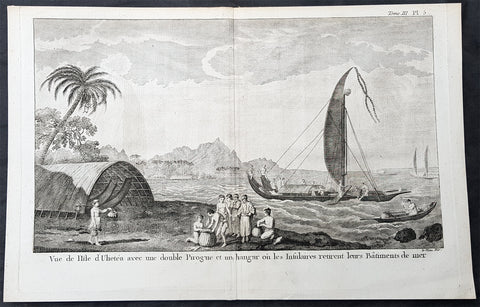
1774 Capt Cook Antique Print View of Raiatea Island, French Polynesia in 1769
- Title : Vue de I Isle d Ulietea avec une double Pirogue et un hanger ou les Insulares retirent leurs Batiments de mer (A view in the island of Ulietea with a double canoe and a boathouse)
- Size: 15in x 10in (380mm x 255mm)
- Ref #: 21616
- Date : 1774
- Condition: (A+) Fine Condition
Description:
This fine original copper-plate engraved antique print a view of fishing vessels, locals inspecting the days catch and views of the Island of Raiatea (Ulietea) in the Society Isles of French Polynesia, visited by Captain Cook in HMS Endeavor during his first visit to the Island in 1769, was engraved by Le Veau - after Sydney Parkinson - was published in the 1774 French edition of John Hawkesworths An Account of the Voyages Undertaken by the Order of His Present Majesty for Making Discoveries in the Southern Hemisphere and Successively Performed by Commodore Byron, Captain Wallis, Captain Carteret, and Captain Cook, in the Dolphin, the Swallow, and the Endeavor, Drawn Up from the Journals Which Were Kept by the Several Commanders, and from the Papers of Joseph Banks, Esq. Paris 1774.
..........a double canoe (pahi) with carved figures on bow and stern. Another double canoe in the background at right and a boathouse at left. There are a great number of boathouses all round the bays built with a Catanarian arch, thatched all over; and the boats kept in them are very long, bellying out on the sides, with a very high peak stern, and are used only at particular seasons.....from the account by Sydney Parkinson 1769
General Definitions:
Paper thickness and quality: - Heavy and stable
Paper color : - off white
Age of map color: -
Colors used: -
General color appearance: -
Paper size: - 15in x 10in (380mm x 255mm)
Plate size: - 14 1/2in x 9 1/2in (370mm x 240mm)
Margins: - Min 1/2in (12mm)
Imperfections:
Margins: - None
Plate area: - None
Verso: - None
Background:
Raiatea, is the second largest of the Society Islands, after Tahiti, in French Polynesia. The island is widely regarded as the centre of the eastern islands in ancient Polynesia and it is likely that the organised migrations to Hawaii, Aotearoa and other parts of East Polynesia started at Raiātea.
Captain Cook visited Raiatea in 1769 and again in 1773-1774.
John Hawkesworth 1715 – 1773
An English writer and journalist, Hawkesworth was commissioned by the British Admiralty to edit for publication the narratives of its officers’ circumnavigations. He was given full access to the journals of the commanders and the freedom to adapt and re-tell them in the first person. Cook was already on his way back from his second Pacific voyage, temporarily docked at Cape Town (South Africa), when he first saw the published volumes: he was mortified and furious to find that Hawkesworth claimed in the introduction that Cook had seen and blessed (with slight corrections) the resulting manuscript. (In his defense, Hawkesworth also had been a victim of misunderstanding.) Cook had trouble recognizing himself. Moreover, the work was full of errors and commentary introduced by Hawkesworth and, in Cook’s view, too full of Banks, who had promoted himself and the publication. Still, the work was popular; the first edition sold out in several months.
Sydney Parkinson 1745 – 71 was draughtsman to the botanist Sir Joseph Banks on James Cook’s first voyage to the Pacific in 1768. He died of dysentery in 1771, on the homeward voyage.
Parkinson was the first European artist to create drawings of Indigenous Australian, Maori & South Sea peoples, as well as landscapes, from direct observation. Hundreds of his original drawings survive in the British Museum. He is particularly remembered for his plant illustrations which were later used to create the lavish plates for Joseph Banks’ Florilegium.
When the Endeavour returned to England in 1772, a dispute arose between Joseph Banks and Sydney’s brother, Stanfield Parkinson. As his employer, Banks claimed rights to Sydney’s drawings, papers and collections made on the voyage. Stanfield claimed that Sydney had willed them to his family. Banks lent the Parkinson family Sydney’s journal and drawings with instructions that they were not to be published, however Stanfield disregarded this and arranged for A Journal of a voyage to the South Seas to be printed from Sydney’s account of the voyage.
Banks managed to suppress Stanfield’s publication until the official account of the voyage, edited by John Hawkesworth, appeared. In return for Parkinson’s papers, Banks paid Stanfield Parkinson 500 pounds for balance of wages due to Sydney, but the dispute did not end there. Stanfield further accused Banks of retaining items collected by Sydney which were intended for his relatives. Stanfield Parkinson was declared insane soon after the publication of Sydney Parkinson’s Journal and died in an asylum.
Robert Bénard 1734 – 1777 was an 18th-century French engraver.
Specialized in the technique of engraving, Robert Ménard is mainly famous for having supplied a significant amount of plates (at least 1,800) to the Encyclopédie by Diderot & d\'Alembert from 1751.
Later, publisher Charles-Joseph Panckoucke reused many of his productions to illustrate the works of his catalog.
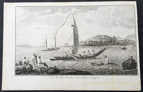
1778 Capt Cook Antique Print View of Matavia Bay Tahiti French Polynesia in 1773
- Title : Vue de I Isle d Otahiti et de plusieurs Pirogues (View of the Island of Tahiti and several canoes)
- Size: 15 1/2in x 10in (390mm x 255mm)
- Ref #: 16085
- Date : 1778
- Condition: (A+) Fine Condition
Description:
This large original copper-plate engraved antique print a view of
Matavia Bay, on the Island of Tahiti, with various canoes & boats, visited by Captain James Cook in August 1773, during his 2nd Voyage of Discovery to the South Seas, was engraved by Robert Benard - after William Hodges - and was published in the 1778 French edition of Capt. James Cooks 2nd Voyage of Discovery to the South Seas A voyage towards the South Pole, and round the World. Performed in His Majestys ships the Resolution and Adventure, in the years 1772, 1773, 1774, and 1775..... Paris : Hotel de Thou ......1778.
Cooks Journal 1773
On 20th Aug, wrote Cook, Nothing worthy of note happened till the Dusk of the evening when one of the Natives made off with a musquet belonging to the Guard on shore, I was present when this happen\'d and sent two or three of our people after him, this would have signified but little had not some of the natives pursued the thief, knock\'d him down and took from him the Musquet and return\'d it to us.
Three days later I set out accompanied by Captain Furneaux some of the Gentlemen and several of the Natives, we met the Chief... I knew him at first sight and he me, having seen each other several times in 1769 at which time he was but a boy. According to Wales the Capt returned from his Visit to the King, Owhyadoa, having with much difficulty, and expince in presents &c procured three Hogs.
Off to Matavai Bay
The next day, wrote Burney we hove our Anchors up & saild from this place, the Commodore leaving his Cutter behind to try if they could procure any more Hogs - the next day (25th) the Cutter returned about Noon with 10 which were divided between the 2 Ships - at 7 this Evening we Anchored in Matavia Bay in 10 fathoms & Moord with our Small Bower & Stream Anchors.
When the natives came aboard, Cook found several of whom I knew and almost all of them me... In the morning, after having given directions about erecting Tents for the reception of the Sick, Coopers and guard, I set out for Oparre accompanied by Captain Furneaux, some of the gentlemen... as soon as we landed we were conducted to Otoo [Tu], the chief.
When Cook returned, he had the Sick land, Twenty from the Adventure and one from the Resolution, landed a sufficient number of men to guard the Whole and left the command to Lieutt Edgcombe of the Marines. A party of Marines being sent on Shore as a Guard, wrote Wales, I landed my Observatory and Instruments and begun to put them up on the Spot where Mr Green Observed the Transit of Venus in 1769.
General Definitions:
Paper thickness and quality: - Heavy and stable
Paper color : - off white
Age of map color: -
Colors used: -
General color appearance: -
Paper size: - 15 1/2in x 10in (390mm x 255mm)
Plate size: - 14 1/2in x 9 1/2in (370mm x 240mm)
Margins: - Min 1/2in (12mm)
Imperfections:
Margins: - None
Plate area: - Folds as issued
Verso: - None
Background:
Tahiti previously also known as Otaheite is the largest island in the Windward group of French Polynesia. The island is located in the archipelago of the Society Islands in the central Southern Pacific Ocean.
The first European to have visited Tahiti according to existing records was lieutenant Samuel Wallis, who was circumnavigating the globe in HMS Dolphin, sighting the island on 18 June 1767, and eventually harboring in Matavai Bay. This bay was situated on the territory of the chiefdom of Pare-Arue, governed by Tu (Tu-nui-e-a a-i-te-Atua) and his regent Tutaha, and the chiefdom of Ha apape, governed by Amo and his wife Oberea (Purea). Wallis named the island King Georges Island. The first contacts were difficult, since on the 24 and 26 June 1767, Tahitian warriors in canoes showed aggression towards the British, hurling stones from their slings. In retaliation, the British sailors opened fire on the warriors in the canoes and on the hills. In reaction to this powerful counter-attack, the Tahitians laid down peace offerings for the British. Following this episode, Samuel Wallis was able to establish cordial relations with the female chieftain “Oberea “ (Purea) and remained on the island until 27 July 1767.
In July 1768, Captain James Cook was commissioned by the Royal Society and on orders from the Lords Commissioners of the Admiralty to observe the transit of Venus across the sun, a phenomenon that would be visible from Tahiti on 3 June 1769. He arrived in Tahitis Matavai Bay, commanding the HMS Endeavour on 12 April 1769. On 14 April, Cook met with Tutaha and Tepau. On 15 April, Cook picked the site for a fortified camp at Point Venus along with Banks, Parkinson, Daniel Solander, to protect Charles Greens observatory. The length of stay enabled them to undertake for the first time real ethnographic and scientific observations of the island. Assisted by the botanist Joseph Banks, and by the artist Sydney Parkinson, Cook gathered valuable information on the fauna and flora, as well as the native society, language and customs, including the proper name of the island, Otaheite. On 28 April, Cook met Purea and Tupaia, and Tupaia befriended Banks following the transit. On 21 June, Amo visited Cook, and then on 25 June, Pohuetea visited, signifying another chief seeking to ally himself with the British.
Cook and Banks circumnavigated the island from 26 June to 1 July. On the exploration, they met Ahio, chief of Ha apaiano o or Papenoo, Rita, chief of Hitia a, Pahairro, chief of Pueu, Vehiatua, chief of Tautra, Matahiapo, chief of Teahupo o, Tutea, chief of Vaira o, and Moe, chief of Afa Ahiti. In Papara, guided by Tupaia, they investigated the ruins of Mahaiatea marae, an impressive structure containing a stone pyramid or ahu, measuring 44 feet high, 267 feet long and 87 feet wide. Cook and the Endeavour departed Tahiti on 13 July 1769, taking Raiatean navigator Tupaia along for his geographic knowledge of the islands.
Cook returned to Tahiti between 15 August and 1 September 1773, greeted by the chiefs Tai and Puhi, besides the youg ari i Vehiatua II and his stepfather Ti itorea. Cook anchored in Vaitepiha Bay before returning to Point Venus where he met Tu, the paramount chief. Cook picked up two passengers from Tahiti during this trip, Porea and Mai, with Hitihiti later replacing Porea when Cook stopped at Raiatea. Cook took Hitihiti to Tahiti on 22 April, during his return leg. Then, Cook departed Tahiti on 14 May 1774.
During his final visit, Cook returned Mai to Tahiti on 12 Aug. 1777, after Mais long visit in England. Cook also brought two Maori from Queen Charlotte Sound, Te Weherua and Koa. Cook first harbored in Vaitepiha Bay, where he visited Vehiatua II s funeral bier and the prefabricated Spanish mission house. Cook also met Vehiatua III, and inscribed on the back of the Spanish cross, Georgius tertius Rex Annis 1767, 69, 73, 74 & 77, as a counterpoint to Christus Vincit Carolus III imperat 1774 on the front. On 23 Aug., Cook sailed for Matavai Bay, where he met Tu, his father Teu, his mother Tetupaia, his brothers Ari ipaea and Vaetua, and his sisters Ari ipaea-vahine, Tetua-te-ahamai, and Auo. Cook also observed a human sacrifice, taata tapu, at the Utu-ai-mahurau marae, and 49 skulls from previous victims.
On 29 Sept. 1777, Cook sailed for Papetoai Bay on Moorea. Cook met Mahine in an act of friendship on 3 Oct., though he was an enemy of Tu. When a goat kid was stolen on 6 Oct., Cook in a rampage, ordered the burning of houses and canoes until it was returned. Cook sailed for Huahine on 11 Oct., Raiatea on 2 Nov., and Borabora on 7 Dec.
On 26 October 1788, HMS Bounty, under the command of Captain William Bligh, landed in Tahiti with the mission of carrying Tahitian breadfruit trees (Tahitian: uru) to the Caribbean. Sir Joseph Banks, the botanist from James Cooks first expedition, had concluded that this plant would be ideal to feed the African slaves working in the Caribbean plantations at very little cost. The crew remained in Tahiti for about five months, the time needed to transplant the seedlings of the trees. Three weeks after leaving Tahiti, on 28 April 1789, the crew mutinied on the initiative of Fletcher Christian. The mutineers seized the ship and set the captain and most of those members of the crew who remained loyal to him adrift in a ships boat. A group of mutineers then went back to settle in Tahiti.
Although various explorers had refused to get involved in tribal conflicts, the mutineers from the Bounty offered their services as mercenaries and furnished arms to the family which became the Pōmare Dynasty. The chief Tū knew how to use their presence in the harbours favoured by sailors to his advantage. As a result of his alliance with the mutineers, he succeeded in considerably increasing his supremacy over the island of Tahiti.
William Hodges RA 1744 – 1797 was an English painter. He was a member of James Cooks second voyage to the Pacific Ocean, and is best known for the sketches and paintings of locations he visited on that voyage, including Table Bay, Tahiti, Easter Island, and the Antarctic.
Between 1772 and 1775 Hodges accompanied James Cook to the Pacific as the expeditions artist. Many of his sketches and wash paintings were adapted as engravings in the original published edition of Cooks journals from the voyage.
Most of the large-scale landscape oil paintings from his Pacific travels for which Hodges is best known were finished after his return to London; he received a salary from the Admiralty for the purposes of completing them. These paintings depicted a stronger light and shadow than had been usual in European landscape tradition. Contemporary art critics complained that his use of light and colour contrasts gave his paintings a rough and unfinished appearance.
Hodges also produced many valuable portrait sketches of Pacific islanders and scenes from the voyage involving members of the expedition..
Robert Bénard 1734 – 1777 was an 18th-century French engraver.
Specialized in the technique of engraving, Robert Ménard is mainly famous for having supplied a significant amount of plates (at least 1,800) to the Encyclopédie by Diderot & d\'Alembert from 1751.
Later, publisher Charles-Joseph Panckoucke reused many of his productions to illustrate the works of his catalog.
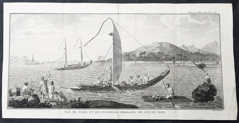
1778 Capt Cook Antique Print Matavia Bay & Boats in Tahiti French Polynesia 1773
- Title : Vue de Taiti et de plusieurs Pirogues De Cette Isle (View of the Island of Tahiti and canoes)
- Size: 15in x 7 1/2in (380mm x 190mm)
- Ref #: 21576
- Date : 1778
- Condition: (A+) Fine Condition
Description:
This large original copper-plate engraved antique print a view of
Matavia Bay, on the Island of Tahiti, with various canoes & boats, visited by Captain James Cook in August 1773, during his 2nd Voyage of Discovery to the South Seas, was engraved by Robert Benard - after William Hodges - and was published in the 1778 French edition of Capt. James Cooks 2nd Voyage of Discovery to the South Seas A voyage towards the South Pole, and round the World. Performed in His Majestys ships the Resolution and Adventure, in the years 1772, 1773, 1774, and 1775..... Paris : Hotel de Thou ......1778.
Cooks Journal 1773
On 20th Aug, wrote Cook, Nothing worthy of note happened till the Dusk of the evening when one of the Natives made off with a musquet belonging to the Guard on shore, I was present when this happen\'d and sent two or three of our people after him, this would have signified but little had not some of the natives pursued the thief, knock\'d him down and took from him the Musquet and return\'d it to us.
Three days later I set out accompanied by Captain Furneaux some of the Gentlemen and several of the Natives, we met the Chief... I knew him at first sight and he me, having seen each other several times in 1769 at which time he was but a boy. According to Wales the Capt returned from his Visit to the King, Owhyadoa, having with much difficulty, and expince in presents &c procured three Hogs.
Off to Matavai Bay
The next day, wrote Burney we hove our Anchors up & saild from this place, the Commodore leaving his Cutter behind to try if they could procure any more Hogs - the next day (25th) the Cutter returned about Noon with 10 which were divided between the 2 Ships - at 7 this Evening we Anchored in Matavia Bay in 10 fathoms & Moord with our Small Bower & Stream Anchors.
When the natives came aboard, Cook found several of whom I knew and almost all of them me... In the morning, after having given directions about erecting Tents for the reception of the Sick, Coopers and guard, I set out for Oparre accompanied by Captain Furneaux, some of the gentlemen... as soon as we landed we were conducted to Otoo [Tu], the chief.
When Cook returned, he had the Sick land, Twenty from the Adventure and one from the Resolution, landed a sufficient number of men to guard the Whole and left the command to Lieutt Edgcombe of the Marines. A party of Marines being sent on Shore as a Guard, wrote Wales, I landed my Observatory and Instruments and begun to put them up on the Spot where Mr Green Observed the Transit of Venus in 1769.
General Definitions:
Paper thickness and quality: - Heavy and stable
Paper color : - off white
Age of map color: -
Colors used: -
General color appearance: -
Paper size: - 15in x 7 1/2in (380mm x 190mm)
Plate size: - 14 1/2in x 7in (370mm x 180mm)
Margins: - Min 1/2in (12mm)
Imperfections:
Margins: - None
Plate area: - Folds as issued
Verso: - None
Background:
Tahiti previously also known as Otaheite is the largest island in the Windward group of French Polynesia. The island is located in the archipelago of the Society Islands in the central Southern Pacific Ocean.
The first European to have visited Tahiti according to existing records was lieutenant Samuel Wallis, who was circumnavigating the globe in HMS Dolphin, sighting the island on 18 June 1767, and eventually harboring in Matavai Bay. This bay was situated on the territory of the chiefdom of Pare-Arue, governed by Tu (Tu-nui-e-a a-i-te-Atua) and his regent Tutaha, and the chiefdom of Ha apape, governed by Amo and his wife Oberea (Purea). Wallis named the island King Georges Island. The first contacts were difficult, since on the 24 and 26 June 1767, Tahitian warriors in canoes showed aggression towards the British, hurling stones from their slings. In retaliation, the British sailors opened fire on the warriors in the canoes and on the hills. In reaction to this powerful counter-attack, the Tahitians laid down peace offerings for the British. Following this episode, Samuel Wallis was able to establish cordial relations with the female chieftain “Oberea “ (Purea) and remained on the island until 27 July 1767.
In July 1768, Captain James Cook was commissioned by the Royal Society and on orders from the Lords Commissioners of the Admiralty to observe the transit of Venus across the sun, a phenomenon that would be visible from Tahiti on 3 June 1769. He arrived in Tahitis Matavai Bay, commanding the HMS Endeavour on 12 April 1769. On 14 April, Cook met with Tutaha and Tepau. On 15 April, Cook picked the site for a fortified camp at Point Venus along with Banks, Parkinson, Daniel Solander, to protect Charles Greens observatory. The length of stay enabled them to undertake for the first time real ethnographic and scientific observations of the island. Assisted by the botanist Joseph Banks, and by the artist Sydney Parkinson, Cook gathered valuable information on the fauna and flora, as well as the native society, language and customs, including the proper name of the island, Otaheite. On 28 April, Cook met Purea and Tupaia, and Tupaia befriended Banks following the transit. On 21 June, Amo visited Cook, and then on 25 June, Pohuetea visited, signifying another chief seeking to ally himself with the British.
Cook and Banks circumnavigated the island from 26 June to 1 July. On the exploration, they met Ahio, chief of Ha apaiano o or Papenoo, Rita, chief of Hitia a, Pahairro, chief of Pueu, Vehiatua, chief of Tautra, Matahiapo, chief of Teahupo o, Tutea, chief of Vaira o, and Moe, chief of Afa Ahiti. In Papara, guided by Tupaia, they investigated the ruins of Mahaiatea marae, an impressive structure containing a stone pyramid or ahu, measuring 44 feet high, 267 feet long and 87 feet wide. Cook and the Endeavour departed Tahiti on 13 July 1769, taking Raiatean navigator Tupaia along for his geographic knowledge of the islands.
Cook returned to Tahiti between 15 August and 1 September 1773, greeted by the chiefs Tai and Puhi, besides the youg ari i Vehiatua II and his stepfather Ti itorea. Cook anchored in Vaitepiha Bay before returning to Point Venus where he met Tu, the paramount chief. Cook picked up two passengers from Tahiti during this trip, Porea and Mai, with Hitihiti later replacing Porea when Cook stopped at Raiatea. Cook took Hitihiti to Tahiti on 22 April, during his return leg. Then, Cook departed Tahiti on 14 May 1774.
During his final visit, Cook returned Mai to Tahiti on 12 Aug. 1777, after Mais long visit in England. Cook also brought two Maori from Queen Charlotte Sound, Te Weherua and Koa. Cook first harbored in Vaitepiha Bay, where he visited Vehiatua II s funeral bier and the prefabricated Spanish mission house. Cook also met Vehiatua III, and inscribed on the back of the Spanish cross, Georgius tertius Rex Annis 1767, 69, 73, 74 & 77, as a counterpoint to Christus Vincit Carolus III imperat 1774 on the front. On 23 Aug., Cook sailed for Matavai Bay, where he met Tu, his father Teu, his mother Tetupaia, his brothers Ari ipaea and Vaetua, and his sisters Ari ipaea-vahine, Tetua-te-ahamai, and Auo. Cook also observed a human sacrifice, taata tapu, at the Utu-ai-mahurau marae, and 49 skulls from previous victims.
On 29 Sept. 1777, Cook sailed for Papetoai Bay on Moorea. Cook met Mahine in an act of friendship on 3 Oct., though he was an enemy of Tu. When a goat kid was stolen on 6 Oct., Cook in a rampage, ordered the burning of houses and canoes until it was returned. Cook sailed for Huahine on 11 Oct., Raiatea on 2 Nov., and Borabora on 7 Dec.
On 26 October 1788, HMS Bounty, under the command of Captain William Bligh, landed in Tahiti with the mission of carrying Tahitian breadfruit trees (Tahitian: uru) to the Caribbean. Sir Joseph Banks, the botanist from James Cooks first expedition, had concluded that this plant would be ideal to feed the African slaves working in the Caribbean plantations at very little cost. The crew remained in Tahiti for about five months, the time needed to transplant the seedlings of the trees. Three weeks after leaving Tahiti, on 28 April 1789, the crew mutinied on the initiative of Fletcher Christian. The mutineers seized the ship and set the captain and most of those members of the crew who remained loyal to him adrift in a ships boat. A group of mutineers then went back to settle in Tahiti.
Although various explorers had refused to get involved in tribal conflicts, the mutineers from the Bounty offered their services as mercenaries and furnished arms to the family which became the Pōmare Dynasty. The chief Tū knew how to use their presence in the harbours favoured by sailors to his advantage. As a result of his alliance with the mutineers, he succeeded in considerably increasing his supremacy over the island of Tahiti.
William Hodges RA 1744 – 1797 was an English painter. He was a member of James Cooks second voyage to the Pacific Ocean, and is best known for the sketches and paintings of locations he visited on that voyage, including Table Bay, Tahiti, Easter Island, and the Antarctic.
Between 1772 and 1775 Hodges accompanied James Cook to the Pacific as the expeditions artist. Many of his sketches and wash paintings were adapted as engravings in the original published edition of Cooks journals from the voyage.
Most of the large-scale landscape oil paintings from his Pacific travels for which Hodges is best known were finished after his return to London; he received a salary from the Admiralty for the purposes of completing them. These paintings depicted a stronger light and shadow than had been usual in European landscape tradition. Contemporary art critics complained that his use of light and colour contrasts gave his paintings a rough and unfinished appearance.
Hodges also produced many valuable portrait sketches of Pacific islanders and scenes from the voyage involving members of the expedition..
Robert Bénard 1734 – 1777 was an 18th-century French engraver.
Specialized in the technique of engraving, Robert Ménard is mainly famous for having supplied a significant amount of plates (at least 1,800) to the Encyclopédie by Diderot & d\'Alembert from 1751.
Later, publisher Charles-Joseph Panckoucke reused many of his productions to illustrate the works of his catalog.
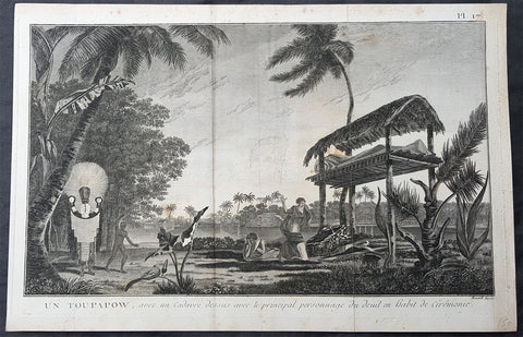
1778 Capt Cook Antique Print of Manao tupapau or Spirit Watching in Tahiti, 1773
- Title : Un Toupapow, avec un Cadavre dessus avec le principal personnage du deuil en habit de Ceremonie (Manao tupapau Ceremony with a corpse top with the main character of the mourning ceremony dress)
- Size: 15in x 10in (380mm x 255mm)
- Ref #: 31848
- Date : 1774
- Condition: (A) Very Good Condition
Description:
This large original copper-plate engraved antique print of the Spirit of the Dead Watching (Manao tupapau) in Tahiti with priest and mourners, visited by Captain James Cook in 1773, during his 2nd Voyage of Discovery to the South Seas, was engraved by Robert Benard - after William Hodges - and was published in the 1778 French edition of Capt. James Cooks 2nd Voyage of Discovery to the South Seas A voyage towards the South Pole, and round the World. Performed in His Majestys ships the Resolution and Adventure, in the years 1772, 1773, 1774, and 1775..... Paris : Hotel de Thou ......1778.
Ghosts in Polynesian culture
There was widespread belief in ghosts in Polynesian culture, some of which persists today. After death, a person\'s ghost would normally travel to the sky world or the underworld, but some could stay on earth. In many Polynesian legends, ghosts were often involved in the affairs of the living. Ghosts might also cause sickness or even invade the body of ordinary people, to be driven out through strong medicines.
In the reconstructed Proto-Polynesian language, the word qaitu refers to a ghost, the spirit of a dead person, while the word tupuqa has a broader meaning including all supernatural beings. Some of the ancient Māui legends that are common throughout the Polynesian islands include the idea of a double soul inhabiting the body. One was the soul which never forsakes man, and the other the soul that could be separated or charmed away from the body by incantations was the hau.
In some societies, the tattoo marks on the Polynesian\'s face indicated their cult. A spiral symbol meant that the man favoured the sky world, but before ascending there on a whirlwind his ghost had to travel to his people\'s homeland, situated in the navel of the world. Different markings indicated that the ghost chose to live in the underworld. The Hawaiians believed in aumakua, ghosts who did not go down into Po, the land of King Milu. These ghosts remained in the land of the living, guarding their former families.
Of his 1892 Tahitian painting Manao Tupapau, Paul Gauguin said according to Tahitian beliefs, the title Manao Tupapau has a double meaning . . . either she thinks of the ghost or the ghost thinks of her.
General Definitions:
Paper thickness and quality: - Heavy and stable
Paper color : - off white
Age of map color: -
Colors used: -
General color appearance: -
Paper size: - 15in x 10in (380mm x 255mm)
Plate size: - 15in x 9 1/2in (380mm x 245mm)
Margins: - Min 1/2in (12mm)
Imperfections:
Margins: - None
Plate area: - None
Verso: - None
Background:
Tahiti previously also known as Otaheite is the largest island in the Windward group of French Polynesia. The island is located in the archipelago of the Society Islands in the central Southern Pacific Ocean.
The first European to have visited Tahiti according to existing records was lieutenant Samuel Wallis, who was circumnavigating the globe in HMS Dolphin, sighting the island on 18 June 1767, and eventually harboring in Matavai Bay. This bay was situated on the territory of the chiefdom of Pare-Arue, governed by Tu (Tu-nui-e-a a-i-te-Atua) and his regent Tutaha, and the chiefdom of Ha apape, governed by Amo and his wife Oberea (Purea). Wallis named the island King Georges Island. The first contacts were difficult, since on the 24 and 26 June 1767, Tahitian warriors in canoes showed aggression towards the British, hurling stones from their slings. In retaliation, the British sailors opened fire on the warriors in the canoes and on the hills. In reaction to this powerful counter-attack, the Tahitians laid down peace offerings for the British. Following this episode, Samuel Wallis was able to establish cordial relations with the female chieftain “Oberea “ (Purea) and remained on the island until 27 July 1767.
In July 1768, Captain James Cook was commissioned by the Royal Society and on orders from the Lords Commissioners of the Admiralty to observe the transit of Venus across the sun, a phenomenon that would be visible from Tahiti on 3 June 1769. He arrived in Tahitis Matavai Bay, commanding the HMS Endeavour on 12 April 1769. On 14 April, Cook met with Tutaha and Tepau. On 15 April, Cook picked the site for a fortified camp at Point Venus along with Banks, Parkinson, Daniel Solander, to protect Charles Greens observatory. The length of stay enabled them to undertake for the first time real ethnographic and scientific observations of the island. Assisted by the botanist Joseph Banks, and by the artist Sydney Parkinson, Cook gathered valuable information on the fauna and flora, as well as the native society, language and customs, including the proper name of the island, Otaheite. On 28 April, Cook met Purea and Tupaia, and Tupaia befriended Banks following the transit. On 21 June, Amo visited Cook, and then on 25 June, Pohuetea visited, signifying another chief seeking to ally himself with the British.
Cook and Banks circumnavigated the island from 26 June to 1 July. On the exploration, they met Ahio, chief of Ha apaiano o or Papenoo, Rita, chief of Hitia a, Pahairro, chief of Pueu, Vehiatua, chief of Tautra, Matahiapo, chief of Teahupo o, Tutea, chief of Vaira o, and Moe, chief of Afa Ahiti. In Papara, guided by Tupaia, they investigated the ruins of Mahaiatea marae, an impressive structure containing a stone pyramid or ahu, measuring 44 feet high, 267 feet long and 87 feet wide. Cook and the Endeavour departed Tahiti on 13 July 1769, taking Raiatean navigator Tupaia along for his geographic knowledge of the islands.
Cook returned to Tahiti between 15 August and 1 September 1773, greeted by the chiefs Tai and Puhi, besides the youg ari i Vehiatua II and his stepfather Ti itorea. Cook anchored in Vaitepiha Bay before returning to Point Venus where he met Tu, the paramount chief. Cook picked up two passengers from Tahiti during this trip, Porea and Mai, with Hitihiti later replacing Porea when Cook stopped at Raiatea. Cook took Hitihiti to Tahiti on 22 April, during his return leg. Then, Cook departed Tahiti on 14 May 1774.
During his final visit, Cook returned Mai to Tahiti on 12 Aug. 1777, after Mais long visit in England. Cook also brought two Maori from Queen Charlotte Sound, Te Weherua and Koa. Cook first harbored in Vaitepiha Bay, where he visited Vehiatua II s funeral bier and the prefabricated Spanish mission house. Cook also met Vehiatua III, and inscribed on the back of the Spanish cross, Georgius tertius Rex Annis 1767, 69, 73, 74 & 77, as a counterpoint to Christus Vincit Carolus III imperat 1774 on the front. On 23 Aug., Cook sailed for Matavai Bay, where he met Tu, his father Teu, his mother Tetupaia, his brothers Ari ipaea and Vaetua, and his sisters Ari ipaea-vahine, Tetua-te-ahamai, and Auo. Cook also observed a human sacrifice, taata tapu, at the Utu-ai-mahurau marae, and 49 skulls from previous victims.
On 29 Sept. 1777, Cook sailed for Papetoai Bay on Moorea. Cook met Mahine in an act of friendship on 3 Oct., though he was an enemy of Tu. When a goat kid was stolen on 6 Oct., Cook in a rampage, ordered the burning of houses and canoes until it was returned. Cook sailed for Huahine on 11 Oct., Raiatea on 2 Nov., and Borabora on 7 Dec.
On 26 October 1788, HMS Bounty, under the command of Captain William Bligh, landed in Tahiti with the mission of carrying Tahitian breadfruit trees (Tahitian: uru) to the Caribbean. Sir Joseph Banks, the botanist from James Cooks first expedition, had concluded that this plant would be ideal to feed the African slaves working in the Caribbean plantations at very little cost. The crew remained in Tahiti for about five months, the time needed to transplant the seedlings of the trees. Three weeks after leaving Tahiti, on 28 April 1789, the crew mutinied on the initiative of Fletcher Christian. The mutineers seized the ship and set the captain and most of those members of the crew who remained loyal to him adrift in a ships boat. A group of mutineers then went back to settle in Tahiti.
Although various explorers had refused to get involved in tribal conflicts, the mutineers from the Bounty offered their services as mercenaries and furnished arms to the family which became the Pōmare Dynasty. The chief Tū knew how to use their presence in the harbours favoured by sailors to his advantage. As a result of his alliance with the mutineers, he succeeded in considerably increasing his supremacy over the island of Tahiti.
Captain James King FRS 1750 – 1784 was an officer of the Royal Navy. He served under James Cook on his last voyage around the world, specialising in taking important astronomical readings using a sextant. After Cook died he helped lead the ships on the remainder of their course, also completing Cooks account of the voyage. He continued his career in the Navy, reaching the rank of post-captain, commanding several ships and serving in the American War of Independence.
King joined HMS Resolution as second lieutenant, sharing the duties of astronomer with Cook, taking astronomical observations on board by sextant and with Larcum Kendals timekeeper K1, to establish the Resolutions position at sea and on shore by sextant or by astronomical quadrant to establish the geographical position of salient points during the course of Cooks surveys. Thus Kings geographical positions were an important contribution to the accuracy of the various surveys carried out during the voyage and his use of the early chronometers helped prove their use at sea for calculation of Longitude. .
Following the death of Cook, King remained in the Resolution but on the death of Charles Clerke, Cooks successor, King was appointed to command HMS Discovery, the Resolutions consort, remaining in her for the rest of the voyage. After his return to England King was very much involved in the publication of the official account of Cooks third voyage, writing the third volume at Woodstock, near Oxford, where his brother Thomas was rector of St Mary Magdalene. But shortly after his return King was promoted Post-captain and appointed commander of HMS Crocodile in the English Channel.
John Webber RA 1751 – 1793 was an English artist who accompanied Captain Cook on his third Pacific expedition. He is best known for his images of Australasia, Hawaii and Alaska.
Webber was born in London, educated in Bern and studied painting at Paris.His father was Abraham Wäber, a Swiss sculptor who had moved to London, and changed his name to Webber before marrying a Mrs Mary Quant in 1744.
Webber served as official artist on James Cooks third voyage of discovery around the Pacific (1776–80) aboard HMS Resolution. At Adventure Bay in January 1777 he did drawings of A Man of Van Diemens Land and A Woman of Van Diemens Land. He also did many drawings of scenes in New Zealand and the South Sea islands. On this voyage, during which Cook lost his life in a fight in Hawaii, Webber became the first European artist to make contact with Hawaii, then called the Sandwich Islands. He made numerous watercolor landscapes of the islands of Kauai and Hawaii, and also portrayed many of the Hawaiian people.
In April 1778, Captain Cooks ships Resolution and Discovery anchored at Ship Cove, now known as Nootka Sound, Vancouver Island, Canada to refit. The crew took observations and recorded encounters with the local people. Webber made watercolour landscapes including Resolution and Discovery in Ship Cove, 1778. His drawings and paintings were engraved for British Admiraltys account of the expedition, which was published in 1784.
Back in England in 1780 Webber exhibited around 50 works at Royal Academy exhibitions between 1784 and 1792, and was elected an associate of the Royal Academy in 1785 and R.A. in 1791. Most of his work were landscapes. Sometimes figures were included as in A Party from H.M.S. Resolution shooting sea horses, which was shown at the academy in 1784, and his The Death of Captain Cook became well known through an engraving of it. Another version of this picture is in the William Dixson gallery at Sydney
Robert Bénard 1734 – 1777 was an 18th-century French engraver.
Specialized in the technique of engraving, Robert Ménard is mainly famous for having supplied a significant amount of plates (at least 1,800) to the Encyclopédie by Diderot & d Alembert from 1751.
Later, publisher Charles-Joseph Panckoucke reused many of his productions to illustrate the works of his catalog.
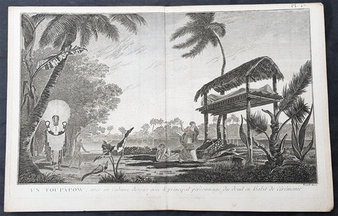
1778 Capt Cook Antique Print of Manao tupapau or Spirit Watching in Tahiti, 1773
- Title : Un Toupapow, avec un Cadavre dessus avec le principal personnage du deuil en habit de Ceremonie (Manao tupapau Ceremony with a corpse top with the main character of the mourning ceremony dress)
- Size: 15in x 10in (380mm x 255mm)
- Ref #: 21652
- Date : 1774
- Condition: (A+) Fine Condition
Description:
This large original copper-plate engraved antique print of the Spirit of the Dead Watching (Manao tupapau) in Tahiti with priest and mourners, visited by Captain James Cook in 1773, during his 2nd Voyage of Discovery to the South Seas, was engraved by Robert Benard - after William Hodges - and was published in the 1778 French edition of Capt. James Cooks 2nd Voyage of Discovery to the South Seas A voyage towards the South Pole, and round the World. Performed in His Majestys ships the Resolution and Adventure, in the years 1772, 1773, 1774, and 1775..... Paris : Hotel de Thou ......1778.
Ghosts in Polynesian culture
There was widespread belief in ghosts in Polynesian culture, some of which persists today. After death, a person\'s ghost would normally travel to the sky world or the underworld, but some could stay on earth. In many Polynesian legends, ghosts were often involved in the affairs of the living. Ghosts might also cause sickness or even invade the body of ordinary people, to be driven out through strong medicines.
In the reconstructed Proto-Polynesian language, the word qaitu refers to a ghost, the spirit of a dead person, while the word tupuqa has a broader meaning including all supernatural beings. Some of the ancient Māui legends that are common throughout the Polynesian islands include the idea of a double soul inhabiting the body. One was the soul which never forsakes man, and the other the soul that could be separated or charmed away from the body by incantations was the hau.
In some societies, the tattoo marks on the Polynesian\'s face indicated their cult. A spiral symbol meant that the man favoured the sky world, but before ascending there on a whirlwind his ghost had to travel to his people\'s homeland, situated in the navel of the world. Different markings indicated that the ghost chose to live in the underworld. The Hawaiians believed in aumakua, ghosts who did not go down into Po, the land of King Milu. These ghosts remained in the land of the living, guarding their former families.
Of his 1892 Tahitian painting Manao Tupapau, Paul Gauguin said according to Tahitian beliefs, the title Manao Tupapau has a double meaning . . . either she thinks of the ghost or the ghost thinks of her.
General Definitions:
Paper thickness and quality: - Heavy and stable
Paper color : - off white
Age of map color: -
Colors used: -
General color appearance: -
Paper size: - 15in x 10in (380mm x 255mm)
Plate size: - 15in x 9 1/2in (380mm x 245mm)
Margins: - Min 1/2in (12mm)
Imperfections:
Margins: - None
Plate area: - None
Verso: - None
Background:
Tahiti previously also known as Otaheite is the largest island in the Windward group of French Polynesia. The island is located in the archipelago of the Society Islands in the central Southern Pacific Ocean.
The first European to have visited Tahiti according to existing records was lieutenant Samuel Wallis, who was circumnavigating the globe in HMS Dolphin, sighting the island on 18 June 1767, and eventually harboring in Matavai Bay. This bay was situated on the territory of the chiefdom of Pare-Arue, governed by Tu (Tu-nui-e-a a-i-te-Atua) and his regent Tutaha, and the chiefdom of Ha apape, governed by Amo and his wife Oberea (Purea). Wallis named the island King Georges Island. The first contacts were difficult, since on the 24 and 26 June 1767, Tahitian warriors in canoes showed aggression towards the British, hurling stones from their slings. In retaliation, the British sailors opened fire on the warriors in the canoes and on the hills. In reaction to this powerful counter-attack, the Tahitians laid down peace offerings for the British. Following this episode, Samuel Wallis was able to establish cordial relations with the female chieftain “Oberea “ (Purea) and remained on the island until 27 July 1767.
In July 1768, Captain James Cook was commissioned by the Royal Society and on orders from the Lords Commissioners of the Admiralty to observe the transit of Venus across the sun, a phenomenon that would be visible from Tahiti on 3 June 1769. He arrived in Tahitis Matavai Bay, commanding the HMS Endeavour on 12 April 1769. On 14 April, Cook met with Tutaha and Tepau. On 15 April, Cook picked the site for a fortified camp at Point Venus along with Banks, Parkinson, Daniel Solander, to protect Charles Greens observatory. The length of stay enabled them to undertake for the first time real ethnographic and scientific observations of the island. Assisted by the botanist Joseph Banks, and by the artist Sydney Parkinson, Cook gathered valuable information on the fauna and flora, as well as the native society, language and customs, including the proper name of the island, Otaheite. On 28 April, Cook met Purea and Tupaia, and Tupaia befriended Banks following the transit. On 21 June, Amo visited Cook, and then on 25 June, Pohuetea visited, signifying another chief seeking to ally himself with the British.
Cook and Banks circumnavigated the island from 26 June to 1 July. On the exploration, they met Ahio, chief of Ha apaiano o or Papenoo, Rita, chief of Hitia a, Pahairro, chief of Pueu, Vehiatua, chief of Tautra, Matahiapo, chief of Teahupo o, Tutea, chief of Vaira o, and Moe, chief of Afa Ahiti. In Papara, guided by Tupaia, they investigated the ruins of Mahaiatea marae, an impressive structure containing a stone pyramid or ahu, measuring 44 feet high, 267 feet long and 87 feet wide. Cook and the Endeavour departed Tahiti on 13 July 1769, taking Raiatean navigator Tupaia along for his geographic knowledge of the islands.
Cook returned to Tahiti between 15 August and 1 September 1773, greeted by the chiefs Tai and Puhi, besides the youg ari i Vehiatua II and his stepfather Ti itorea. Cook anchored in Vaitepiha Bay before returning to Point Venus where he met Tu, the paramount chief. Cook picked up two passengers from Tahiti during this trip, Porea and Mai, with Hitihiti later replacing Porea when Cook stopped at Raiatea. Cook took Hitihiti to Tahiti on 22 April, during his return leg. Then, Cook departed Tahiti on 14 May 1774.
During his final visit, Cook returned Mai to Tahiti on 12 Aug. 1777, after Mais long visit in England. Cook also brought two Maori from Queen Charlotte Sound, Te Weherua and Koa. Cook first harbored in Vaitepiha Bay, where he visited Vehiatua II s funeral bier and the prefabricated Spanish mission house. Cook also met Vehiatua III, and inscribed on the back of the Spanish cross, Georgius tertius Rex Annis 1767, 69, 73, 74 & 77, as a counterpoint to Christus Vincit Carolus III imperat 1774 on the front. On 23 Aug., Cook sailed for Matavai Bay, where he met Tu, his father Teu, his mother Tetupaia, his brothers Ari ipaea and Vaetua, and his sisters Ari ipaea-vahine, Tetua-te-ahamai, and Auo. Cook also observed a human sacrifice, taata tapu, at the Utu-ai-mahurau marae, and 49 skulls from previous victims.
On 29 Sept. 1777, Cook sailed for Papetoai Bay on Moorea. Cook met Mahine in an act of friendship on 3 Oct., though he was an enemy of Tu. When a goat kid was stolen on 6 Oct., Cook in a rampage, ordered the burning of houses and canoes until it was returned. Cook sailed for Huahine on 11 Oct., Raiatea on 2 Nov., and Borabora on 7 Dec.
On 26 October 1788, HMS Bounty, under the command of Captain William Bligh, landed in Tahiti with the mission of carrying Tahitian breadfruit trees (Tahitian: uru) to the Caribbean. Sir Joseph Banks, the botanist from James Cooks first expedition, had concluded that this plant would be ideal to feed the African slaves working in the Caribbean plantations at very little cost. The crew remained in Tahiti for about five months, the time needed to transplant the seedlings of the trees. Three weeks after leaving Tahiti, on 28 April 1789, the crew mutinied on the initiative of Fletcher Christian. The mutineers seized the ship and set the captain and most of those members of the crew who remained loyal to him adrift in a ships boat. A group of mutineers then went back to settle in Tahiti.
Although various explorers had refused to get involved in tribal conflicts, the mutineers from the Bounty offered their services as mercenaries and furnished arms to the family which became the Pōmare Dynasty. The chief Tū knew how to use their presence in the harbours favoured by sailors to his advantage. As a result of his alliance with the mutineers, he succeeded in considerably increasing his supremacy over the island of Tahiti.
Captain James King FRS 1750 – 1784 was an officer of the Royal Navy. He served under James Cook on his last voyage around the world, specialising in taking important astronomical readings using a sextant. After Cook died he helped lead the ships on the remainder of their course, also completing Cooks account of the voyage. He continued his career in the Navy, reaching the rank of post-captain, commanding several ships and serving in the American War of Independence.
King joined HMS Resolution as second lieutenant, sharing the duties of astronomer with Cook, taking astronomical observations on board by sextant and with Larcum Kendals timekeeper K1, to establish the Resolutions position at sea and on shore by sextant or by astronomical quadrant to establish the geographical position of salient points during the course of Cooks surveys. Thus Kings geographical positions were an important contribution to the accuracy of the various surveys carried out during the voyage and his use of the early chronometers helped prove their use at sea for calculation of Longitude. .
Following the death of Cook, King remained in the Resolution but on the death of Charles Clerke, Cooks successor, King was appointed to command HMS Discovery, the Resolutions consort, remaining in her for the rest of the voyage. After his return to England King was very much involved in the publication of the official account of Cooks third voyage, writing the third volume at Woodstock, near Oxford, where his brother Thomas was rector of St Mary Magdalene. But shortly after his return King was promoted Post-captain and appointed commander of HMS Crocodile in the English Channel.
John Webber RA 1751 – 1793 was an English artist who accompanied Captain Cook on his third Pacific expedition. He is best known for his images of Australasia, Hawaii and Alaska.
Webber was born in London, educated in Bern and studied painting at Paris.His father was Abraham Wäber, a Swiss sculptor who had moved to London, and changed his name to Webber before marrying a Mrs Mary Quant in 1744.
Webber served as official artist on James Cooks third voyage of discovery around the Pacific (1776–80) aboard HMS Resolution. At Adventure Bay in January 1777 he did drawings of A Man of Van Diemens Land and A Woman of Van Diemens Land. He also did many drawings of scenes in New Zealand and the South Sea islands. On this voyage, during which Cook lost his life in a fight in Hawaii, Webber became the first European artist to make contact with Hawaii, then called the Sandwich Islands. He made numerous watercolor landscapes of the islands of Kauai and Hawaii, and also portrayed many of the Hawaiian people.
In April 1778, Captain Cooks ships Resolution and Discovery anchored at Ship Cove, now known as Nootka Sound, Vancouver Island, Canada to refit. The crew took observations and recorded encounters with the local people. Webber made watercolour landscapes including Resolution and Discovery in Ship Cove, 1778. His drawings and paintings were engraved for British Admiraltys account of the expedition, which was published in 1784.
Back in England in 1780 Webber exhibited around 50 works at Royal Academy exhibitions between 1784 and 1792, and was elected an associate of the Royal Academy in 1785 and R.A. in 1791. Most of his work were landscapes. Sometimes figures were included as in A Party from H.M.S. Resolution shooting sea horses, which was shown at the academy in 1784, and his The Death of Captain Cook became well known through an engraving of it. Another version of this picture is in the William Dixson gallery at Sydney
Robert Bénard 1734 – 1777 was an 18th-century French engraver.
Specialized in the technique of engraving, Robert Ménard is mainly famous for having supplied a significant amount of plates (at least 1,800) to the Encyclopédie by Diderot & d Alembert from 1751.
Later, publisher Charles-Joseph Panckoucke reused many of his productions to illustrate the works of his catalog.
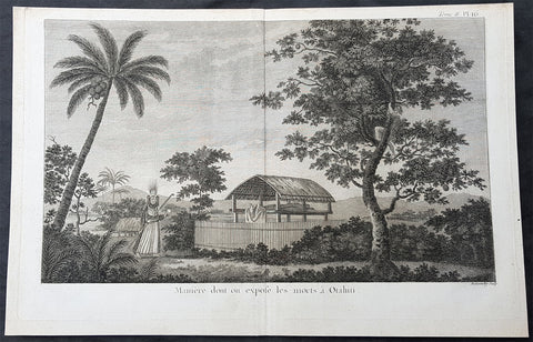
1774 Capt Cook Antqiue Print of Tahitians Honouring the Dead, Manao Tupapau 1769
- Title : Maniere dont on expose les morts a Otahiti (How the dead are exposed on Tahiti)
- Size: 15in x 10 1/2in (395mm x 265mm)
- Ref #: 21733-1
- Date : 1774
- Condition: (A+) Fine Condition
Description:
This fine original copper-plate engraved antique print of how the Dead are left mummified outdoors in an elevated platform in Tahiti, and the ritual of the Spirit of the Dead Watching (Manao tupapau), visited by Captain Cook in HMS Endeavor during his first visit to the Island in 1769, was engraved by Robert Benard - after Sydney Parkinson - was published in the 1774 French edition of John Hawkesworths An Account of the Voyages Undertaken by the Order of His Present Majesty for Making Discoveries in the Southern Hemisphere and Successively Performed by Commodore Byron, Captain Wallis, Captain Carteret, and Captain Cook, in the Dolphin, the Swallow, and the Endeavor, Drawn Up from the Journals Which Were Kept by the Several Commanders, and from the Papers of Joseph Banks, Esq. Paris 1774.
Ghosts in Polynesian culture
There was widespread belief in ghosts in Polynesian culture, some of which persists today. After death, a person\'s ghost would normally travel to the sky world or the underworld, but some could stay on earth. In many Polynesian legends, ghosts were often involved in the affairs of the living. Ghosts might also cause sickness or even invade the body of ordinary people, to be driven out through strong medicines.
In the reconstructed Proto-Polynesian language, the word qaitu refers to a ghost, the spirit of a dead person, while the word tupuqa has a broader meaning including all supernatural beings. Some of the ancient Māui legends that are common throughout the Polynesian islands include the idea of a double soul inhabiting the body. One was the soul which never forsakes man, and the other the soul that could be separated or charmed away from the body by incantations was the hau.
In some societies, the tattoo marks on the Polynesian\'s face indicated their cult. A spiral symbol meant that the man favoured the sky world, but before ascending there on a whirlwind his ghost had to travel to his people\'s homeland, situated in the navel of the world. Different markings indicated that the ghost chose to live in the underworld. The Hawaiians believed in aumakua, ghosts who did not go down into Po, the land of King Milu. These ghosts remained in the land of the living, guarding their former families.
Of his 1892 Tahitian painting Manao Tupapau, Paul Gauguin said according to Tahitian beliefs, the title Manao Tupapau has a double meaning . . . either she thinks of the ghost or the ghost thinks of her.
General Definitions:
Paper thickness and quality: - Heavy and stable
Paper color : - off white
Age of map color: -
Colors used: -
General color appearance: -
Paper size: - 16in x 10 1/2in (405mm x 265mm)
Plate size: - 14 1/2in x 9 1/2in (370mm x 240mm)
Margins: - Min 1/2in (12mm)
Imperfections:
Margins: - None
Plate area: - None
Verso: - None
Background:
Tahiti previously also known as Otaheite is the largest island in the Windward group of French Polynesia. The island is located in the archipelago of the Society Islands in the central Southern Pacific Ocean.
The first European to have visited Tahiti according to existing records was lieutenant Samuel Wallis, who was circumnavigating the globe in HMS Dolphin, sighting the island on 18 June 1767, and eventually harboring in Matavai Bay. This bay was situated on the territory of the chiefdom of Pare-Arue, governed by Tu (Tu-nui-e-a a-i-te-Atua) and his regent Tutaha, and the chiefdom of Ha apape, governed by Amo and his wife Oberea (Purea). Wallis named the island King Georges Island. The first contacts were difficult, since on the 24 and 26 June 1767, Tahitian warriors in canoes showed aggression towards the British, hurling stones from their slings. In retaliation, the British sailors opened fire on the warriors in the canoes and on the hills. In reaction to this powerful counter-attack, the Tahitians laid down peace offerings for the British. Following this episode, Samuel Wallis was able to establish cordial relations with the female chieftain “Oberea “ (Purea) and remained on the island until 27 July 1767.
In July 1768, Captain James Cook was commissioned by the Royal Society and on orders from the Lords Commissioners of the Admiralty to observe the transit of Venus across the sun, a phenomenon that would be visible from Tahiti on 3 June 1769. He arrived in Tahitis Matavai Bay, commanding the HMS Endeavour on 12 April 1769. On 14 April, Cook met with Tutaha and Tepau. On 15 April, Cook picked the site for a fortified camp at Point Venus along with Banks, Parkinson, Daniel Solander, to protect Charles Greens observatory. The length of stay enabled them to undertake for the first time real ethnographic and scientific observations of the island. Assisted by the botanist Joseph Banks, and by the artist Sydney Parkinson, Cook gathered valuable information on the fauna and flora, as well as the native society, language and customs, including the proper name of the island, Otaheite. On 28 April, Cook met Purea and Tupaia, and Tupaia befriended Banks following the transit. On 21 June, Amo visited Cook, and then on 25 June, Pohuetea visited, signifying another chief seeking to ally himself with the British.
Cook and Banks circumnavigated the island from 26 June to 1 July. On the exploration, they met Ahio, chief of Ha apaiano o or Papenoo, Rita, chief of Hitia a, Pahairro, chief of Pueu, Vehiatua, chief of Tautra, Matahiapo, chief of Teahupo o, Tutea, chief of Vaira o, and Moe, chief of Afa Ahiti. In Papara, guided by Tupaia, they investigated the ruins of Mahaiatea marae, an impressive structure containing a stone pyramid or ahu, measuring 44 feet high, 267 feet long and 87 feet wide. Cook and the Endeavour departed Tahiti on 13 July 1769, taking Raiatean navigator Tupaia along for his geographic knowledge of the islands.
Cook returned to Tahiti between 15 August and 1 September 1773, greeted by the chiefs Tai and Puhi, besides the youg ari i Vehiatua II and his stepfather Ti itorea. Cook anchored in Vaitepiha Bay before returning to Point Venus where he met Tu, the paramount chief. Cook picked up two passengers from Tahiti during this trip, Porea and Mai, with Hitihiti later replacing Porea when Cook stopped at Raiatea. Cook took Hitihiti to Tahiti on 22 April, during his return leg. Then, Cook departed Tahiti on 14 May 1774.
During his final visit, Cook returned Mai to Tahiti on 12 Aug. 1777, after Mais long visit in England. Cook also brought two Maori from Queen Charlotte Sound, Te Weherua and Koa. Cook first harbored in Vaitepiha Bay, where he visited Vehiatua II s funeral bier and the prefabricated Spanish mission house. Cook also met Vehiatua III, and inscribed on the back of the Spanish cross, Georgius tertius Rex Annis 1767, 69, 73, 74 & 77, as a counterpoint to Christus Vincit Carolus III imperat 1774 on the front. On 23 Aug., Cook sailed for Matavai Bay, where he met Tu, his father Teu, his mother Tetupaia, his brothers Ari ipaea and Vaetua, and his sisters Ari ipaea-vahine, Tetua-te-ahamai, and Auo. Cook also observed a human sacrifice, taata tapu, at the Utu-ai-mahurau marae, and 49 skulls from previous victims.
On 29 Sept. 1777, Cook sailed for Papetoai Bay on Moorea. Cook met Mahine in an act of friendship on 3 Oct., though he was an enemy of Tu. When a goat kid was stolen on 6 Oct., Cook in a rampage, ordered the burning of houses and canoes until it was returned. Cook sailed for Huahine on 11 Oct., Raiatea on 2 Nov., and Borabora on 7 Dec.
On 26 October 1788, HMS Bounty, under the command of Captain William Bligh, landed in Tahiti with the mission of carrying Tahitian breadfruit trees (Tahitian: uru) to the Caribbean. Sir Joseph Banks, the botanist from James Cooks first expedition, had concluded that this plant would be ideal to feed the African slaves working in the Caribbean plantations at very little cost. The crew remained in Tahiti for about five months, the time needed to transplant the seedlings of the trees. Three weeks after leaving Tahiti, on 28 April 1789, the crew mutinied on the initiative of Fletcher Christian. The mutineers seized the ship and set the captain and most of those members of the crew who remained loyal to him adrift in a ships boat. A group of mutineers then went back to settle in Tahiti.
Although various explorers had refused to get involved in tribal conflicts, the mutineers from the Bounty offered their services as mercenaries and furnished arms to the family which became the Pōmare Dynasty. The chief Tū knew how to use their presence in the harbours favoured by sailors to his advantage. As a result of his alliance with the mutineers, he succeeded in considerably increasing his supremacy over the island of Tahiti.
Captain James King FRS 1750 – 1784 was an officer of the Royal Navy. He served under James Cook on his last voyage around the world, specialising in taking important astronomical readings using a sextant. After Cook died he helped lead the ships on the remainder of their course, also completing Cooks account of the voyage. He continued his career in the Navy, reaching the rank of post-captain, commanding several ships and serving in the American War of Independence.
King joined HMS Resolution as second lieutenant, sharing the duties of astronomer with Cook, taking astronomical observations on board by sextant and with Larcum Kendals timekeeper K1, to establish the Resolutions position at sea and on shore by sextant or by astronomical quadrant to establish the geographical position of salient points during the course of Cooks surveys. Thus Kings geographical positions were an important contribution to the accuracy of the various surveys carried out during the voyage and his use of the early chronometers helped prove their use at sea for calculation of Longitude. .
Following the death of Cook, King remained in the Resolution but on the death of Charles Clerke, Cooks successor, King was appointed to command HMS Discovery, the Resolutions consort, remaining in her for the rest of the voyage. After his return to England King was very much involved in the publication of the official account of Cooks third voyage, writing the third volume at Woodstock, near Oxford, where his brother Thomas was rector of St Mary Magdalene. But shortly after his return King was promoted Post-captain and appointed commander of HMS Crocodile in the English Channel.
John Webber RA 1751 – 1793 was an English artist who accompanied Captain Cook on his third Pacific expedition. He is best known for his images of Australasia, Hawaii and Alaska.
Webber was born in London, educated in Bern and studied painting at Paris.His father was Abraham Wäber, a Swiss sculptor who had moved to London, and changed his name to Webber before marrying a Mrs Mary Quant in 1744.
Webber served as official artist on James Cooks third voyage of discovery around the Pacific (1776–80) aboard HMS Resolution. At Adventure Bay in January 1777 he did drawings of A Man of Van Diemens Land and A Woman of Van Diemens Land. He also did many drawings of scenes in New Zealand and the South Sea islands. On this voyage, during which Cook lost his life in a fight in Hawaii, Webber became the first European artist to make contact with Hawaii, then called the Sandwich Islands. He made numerous watercolor landscapes of the islands of Kauai and Hawaii, and also portrayed many of the Hawaiian people.
In April 1778, Captain Cooks ships Resolution and Discovery anchored at Ship Cove, now known as Nootka Sound, Vancouver Island, Canada to refit. The crew took observations and recorded encounters with the local people. Webber made watercolour landscapes including Resolution and Discovery in Ship Cove, 1778. His drawings and paintings were engraved for British Admiraltys account of the expedition, which was published in 1784.
Back in England in 1780 Webber exhibited around 50 works at Royal Academy exhibitions between 1784 and 1792, and was elected an associate of the Royal Academy in 1785 and R.A. in 1791. Most of his work were landscapes. Sometimes figures were included as in A Party from H.M.S. Resolution shooting sea horses, which was shown at the academy in 1784, and his The Death of Captain Cook became well known through an engraving of it. Another version of this picture is in the William Dixson gallery at Sydney
Robert Bénard 1734 – 1777 was an 18th-century French engraver.
Specialized in the technique of engraving, Robert Ménard is mainly famous for having supplied a significant amount of plates (at least 1,800) to the Encyclopédie by Diderot & d Alembert from 1751.
Later, publisher Charles-Joseph Panckoucke reused many of his productions to illustrate the works of his catalog.
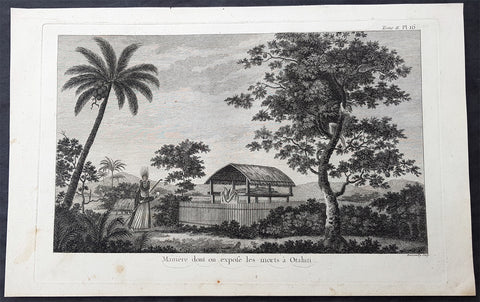
1774 Capt Cook Antqiue Print of Tahitians Honouring the Dead, Manao Tupapau 1769
- Title : Maniere dont on expose les morts a Otahiti (How the dead are exposed on Tahiti)
- Size: 16in x 10 1/2in (405mm x 265mm)
- Ref #: 21427
- Date : 1774
- Condition: (A+) Fine Condition
Description:
This fine original copper-plate engraved antique print of how the Dead are left mummified outdoors in an elevated platform in Tahiti, and the ritual of the Spirit of the Dead Watching (Manao tupapau), visited by Captain Cook in HMS Endeavor during his first visit to the Island in 1769, was engraved by Robert Benard - after Sydney Parkinson - was published in the 1774 French edition of John Hawkesworths An Account of the Voyages Undertaken by the Order of His Present Majesty for Making Discoveries in the Southern Hemisphere and Successively Performed by Commodore Byron, Captain Wallis, Captain Carteret, and Captain Cook, in the Dolphin, the Swallow, and the Endeavor, Drawn Up from the Journals Which Were Kept by the Several Commanders, and from the Papers of Joseph Banks, Esq. Paris 1774.
Ghosts in Polynesian culture
There was widespread belief in ghosts in Polynesian culture, some of which persists today. After death, a person\'s ghost would normally travel to the sky world or the underworld, but some could stay on earth. In many Polynesian legends, ghosts were often involved in the affairs of the living. Ghosts might also cause sickness or even invade the body of ordinary people, to be driven out through strong medicines.
In the reconstructed Proto-Polynesian language, the word qaitu refers to a ghost, the spirit of a dead person, while the word tupuqa has a broader meaning including all supernatural beings. Some of the ancient Māui legends that are common throughout the Polynesian islands include the idea of a double soul inhabiting the body. One was the soul which never forsakes man, and the other the soul that could be separated or charmed away from the body by incantations was the hau.
In some societies, the tattoo marks on the Polynesian\'s face indicated their cult. A spiral symbol meant that the man favoured the sky world, but before ascending there on a whirlwind his ghost had to travel to his people\'s homeland, situated in the navel of the world. Different markings indicated that the ghost chose to live in the underworld. The Hawaiians believed in aumakua, ghosts who did not go down into Po, the land of King Milu. These ghosts remained in the land of the living, guarding their former families.
Of his 1892 Tahitian painting Manao Tupapau, Paul Gauguin said according to Tahitian beliefs, the title Manao Tupapau has a double meaning . . . either she thinks of the ghost or the ghost thinks of her.
General Definitions:
Paper thickness and quality: - Heavy and stable
Paper color : - off white
Age of map color: -
Colors used: -
General color appearance: -
Paper size: - 16in x 10 1/2in (405mm x 265mm)
Plate size: - 14 1/2in x 9 1/2in (370mm x 240mm)
Margins: - Min 1/2in (12mm)
Imperfections:
Margins: - None
Plate area: - None
Verso: - None
Background:
Tahiti previously also known as Otaheite is the largest island in the Windward group of French Polynesia. The island is located in the archipelago of the Society Islands in the central Southern Pacific Ocean.
The first European to have visited Tahiti according to existing records was lieutenant Samuel Wallis, who was circumnavigating the globe in HMS Dolphin, sighting the island on 18 June 1767, and eventually harboring in Matavai Bay. This bay was situated on the territory of the chiefdom of Pare-Arue, governed by Tu (Tu-nui-e-a a-i-te-Atua) and his regent Tutaha, and the chiefdom of Ha apape, governed by Amo and his wife Oberea (Purea). Wallis named the island King Georges Island. The first contacts were difficult, since on the 24 and 26 June 1767, Tahitian warriors in canoes showed aggression towards the British, hurling stones from their slings. In retaliation, the British sailors opened fire on the warriors in the canoes and on the hills. In reaction to this powerful counter-attack, the Tahitians laid down peace offerings for the British. Following this episode, Samuel Wallis was able to establish cordial relations with the female chieftain “Oberea “ (Purea) and remained on the island until 27 July 1767.
In July 1768, Captain James Cook was commissioned by the Royal Society and on orders from the Lords Commissioners of the Admiralty to observe the transit of Venus across the sun, a phenomenon that would be visible from Tahiti on 3 June 1769. He arrived in Tahitis Matavai Bay, commanding the HMS Endeavour on 12 April 1769. On 14 April, Cook met with Tutaha and Tepau. On 15 April, Cook picked the site for a fortified camp at Point Venus along with Banks, Parkinson, Daniel Solander, to protect Charles Greens observatory. The length of stay enabled them to undertake for the first time real ethnographic and scientific observations of the island. Assisted by the botanist Joseph Banks, and by the artist Sydney Parkinson, Cook gathered valuable information on the fauna and flora, as well as the native society, language and customs, including the proper name of the island, Otaheite. On 28 April, Cook met Purea and Tupaia, and Tupaia befriended Banks following the transit. On 21 June, Amo visited Cook, and then on 25 June, Pohuetea visited, signifying another chief seeking to ally himself with the British.
Cook and Banks circumnavigated the island from 26 June to 1 July. On the exploration, they met Ahio, chief of Ha apaiano o or Papenoo, Rita, chief of Hitia a, Pahairro, chief of Pueu, Vehiatua, chief of Tautra, Matahiapo, chief of Teahupo o, Tutea, chief of Vaira o, and Moe, chief of Afa Ahiti. In Papara, guided by Tupaia, they investigated the ruins of Mahaiatea marae, an impressive structure containing a stone pyramid or ahu, measuring 44 feet high, 267 feet long and 87 feet wide. Cook and the Endeavour departed Tahiti on 13 July 1769, taking Raiatean navigator Tupaia along for his geographic knowledge of the islands.
Cook returned to Tahiti between 15 August and 1 September 1773, greeted by the chiefs Tai and Puhi, besides the youg ari i Vehiatua II and his stepfather Ti itorea. Cook anchored in Vaitepiha Bay before returning to Point Venus where he met Tu, the paramount chief. Cook picked up two passengers from Tahiti during this trip, Porea and Mai, with Hitihiti later replacing Porea when Cook stopped at Raiatea. Cook took Hitihiti to Tahiti on 22 April, during his return leg. Then, Cook departed Tahiti on 14 May 1774.
During his final visit, Cook returned Mai to Tahiti on 12 Aug. 1777, after Mais long visit in England. Cook also brought two Maori from Queen Charlotte Sound, Te Weherua and Koa. Cook first harbored in Vaitepiha Bay, where he visited Vehiatua II s funeral bier and the prefabricated Spanish mission house. Cook also met Vehiatua III, and inscribed on the back of the Spanish cross, Georgius tertius Rex Annis 1767, 69, 73, 74 & 77, as a counterpoint to Christus Vincit Carolus III imperat 1774 on the front. On 23 Aug., Cook sailed for Matavai Bay, where he met Tu, his father Teu, his mother Tetupaia, his brothers Ari ipaea and Vaetua, and his sisters Ari ipaea-vahine, Tetua-te-ahamai, and Auo. Cook also observed a human sacrifice, taata tapu, at the Utu-ai-mahurau marae, and 49 skulls from previous victims.
On 29 Sept. 1777, Cook sailed for Papetoai Bay on Moorea. Cook met Mahine in an act of friendship on 3 Oct., though he was an enemy of Tu. When a goat kid was stolen on 6 Oct., Cook in a rampage, ordered the burning of houses and canoes until it was returned. Cook sailed for Huahine on 11 Oct., Raiatea on 2 Nov., and Borabora on 7 Dec.
On 26 October 1788, HMS Bounty, under the command of Captain William Bligh, landed in Tahiti with the mission of carrying Tahitian breadfruit trees (Tahitian: uru) to the Caribbean. Sir Joseph Banks, the botanist from James Cooks first expedition, had concluded that this plant would be ideal to feed the African slaves working in the Caribbean plantations at very little cost. The crew remained in Tahiti for about five months, the time needed to transplant the seedlings of the trees. Three weeks after leaving Tahiti, on 28 April 1789, the crew mutinied on the initiative of Fletcher Christian. The mutineers seized the ship and set the captain and most of those members of the crew who remained loyal to him adrift in a ships boat. A group of mutineers then went back to settle in Tahiti.
Although various explorers had refused to get involved in tribal conflicts, the mutineers from the Bounty offered their services as mercenaries and furnished arms to the family which became the Pōmare Dynasty. The chief Tū knew how to use their presence in the harbours favoured by sailors to his advantage. As a result of his alliance with the mutineers, he succeeded in considerably increasing his supremacy over the island of Tahiti.
Captain James King FRS 1750 – 1784 was an officer of the Royal Navy. He served under James Cook on his last voyage around the world, specialising in taking important astronomical readings using a sextant. After Cook died he helped lead the ships on the remainder of their course, also completing Cooks account of the voyage. He continued his career in the Navy, reaching the rank of post-captain, commanding several ships and serving in the American War of Independence.
King joined HMS Resolution as second lieutenant, sharing the duties of astronomer with Cook, taking astronomical observations on board by sextant and with Larcum Kendals timekeeper K1, to establish the Resolutions position at sea and on shore by sextant or by astronomical quadrant to establish the geographical position of salient points during the course of Cooks surveys. Thus Kings geographical positions were an important contribution to the accuracy of the various surveys carried out during the voyage and his use of the early chronometers helped prove their use at sea for calculation of Longitude. .
Following the death of Cook, King remained in the Resolution but on the death of Charles Clerke, Cooks successor, King was appointed to command HMS Discovery, the Resolutions consort, remaining in her for the rest of the voyage. After his return to England King was very much involved in the publication of the official account of Cooks third voyage, writing the third volume at Woodstock, near Oxford, where his brother Thomas was rector of St Mary Magdalene. But shortly after his return King was promoted Post-captain and appointed commander of HMS Crocodile in the English Channel.
John Webber RA 1751 – 1793 was an English artist who accompanied Captain Cook on his third Pacific expedition. He is best known for his images of Australasia, Hawaii and Alaska.
Webber was born in London, educated in Bern and studied painting at Paris.His father was Abraham Wäber, a Swiss sculptor who had moved to London, and changed his name to Webber before marrying a Mrs Mary Quant in 1744.
Webber served as official artist on James Cooks third voyage of discovery around the Pacific (1776–80) aboard HMS Resolution. At Adventure Bay in January 1777 he did drawings of A Man of Van Diemens Land and A Woman of Van Diemens Land. He also did many drawings of scenes in New Zealand and the South Sea islands. On this voyage, during which Cook lost his life in a fight in Hawaii, Webber became the first European artist to make contact with Hawaii, then called the Sandwich Islands. He made numerous watercolor landscapes of the islands of Kauai and Hawaii, and also portrayed many of the Hawaiian people.
In April 1778, Captain Cooks ships Resolution and Discovery anchored at Ship Cove, now known as Nootka Sound, Vancouver Island, Canada to refit. The crew took observations and recorded encounters with the local people. Webber made watercolour landscapes including Resolution and Discovery in Ship Cove, 1778. His drawings and paintings were engraved for British Admiraltys account of the expedition, which was published in 1784.
Back in England in 1780 Webber exhibited around 50 works at Royal Academy exhibitions between 1784 and 1792, and was elected an associate of the Royal Academy in 1785 and R.A. in 1791. Most of his work were landscapes. Sometimes figures were included as in A Party from H.M.S. Resolution shooting sea horses, which was shown at the academy in 1784, and his The Death of Captain Cook became well known through an engraving of it. Another version of this picture is in the William Dixson gallery at Sydney
Robert Bénard 1734 – 1777 was an 18th-century French engraver.
Specialized in the technique of engraving, Robert Ménard is mainly famous for having supplied a significant amount of plates (at least 1,800) to the Encyclopédie by Diderot & d Alembert from 1751.
Later, publisher Charles-Joseph Panckoucke reused many of his productions to illustrate the works of his catalog.
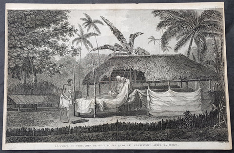
1785 Capt Cook Antique Print The Remains of Chief Vehiatua II (Tu) Tahiti, 1777
- Title : Le Corps De Thee, Chef De O Taiti, Tel Qu on le Conservoit Apres sa Mort. (The body of Thee, Chief of Tahiti Preserved after his death)
- Size: 14 1/2in x 9 1/2in (370mm x 245mm)
- Ref #: 31834
- Date : 1785
- Condition: (A) Very Good Condition
Description:
This fine original copper-plate engraved antique print of the mummified remains of Chief Vehiatua II (Tu), laying in state, on the island of Tahiti visited by Captain Cook in 1777, during his 3rd & last Voyage of Discovery, was engraved by Robert Benard - after John Webber - and was published in the 1785 French edition of Capt. James Cook & Capt. James King publication A Voyage to the Pacific Ocean. Undertaken, by the Command of his Majesty, for making Discoveries in the Northern Hemisphere. To determine The Position and Extent of the West Side of North America; its Distance from Asia; and the Practicability of a Northern Passage to Europe. Performed under the direction of Captains Cook, Clerke, and Gore, In His Majestys Ships the Resolution and Discovery. In the Years 1776, 1777, 1778, 1779, and 1780. In Three Volumes. Vol. I and II written by James Cook, F.R.S. Vol. III by Captain James King, LL.D. and F.R.S. Paris, 1785.
.....during his final visit, Cook returned Omai to Tahiti on 12 Aug. 1777, after Omais long visit in England. Cook also brought two Maori from Queen Charlotte Sound, Te Weherua and Koa. Cook first harbored in Vaitepiha Bay, where he visited Vehiatua IIs funeral bier and the prefabricated Spanish mission house. Cook also met Vehiatua III, and inscribed on the back of the Spanish cross, Georgius tertius Rex Annis 1767, 69, 73, 74 & 77, as a counterpoint to Christus Vincit Carolus III imperat 1774 on the front. On 23 Aug., Cook sailed for Matavai Bay, where he met Tu, his father Teu, his mother Tetupaia, his brothers Ariipaea and Vaetua, and his sisters Ariipaea-vahine, Tetua-te-ahamai, and Auo. Cook also observed a human sacrifice, taata tapu, at the Utu-ai-mahurau marae, and 49 skulls from previous victims....
General Definitions:
Paper thickness and quality: - Heavy and stable
Paper color : - off white
Age of map color: -
Colors used: -
General color appearance: -
Paper size: - 16in x 10 1/2in (405mm x 265mm)
Plate size: - 14 1/2in x 9 1/2in (370mm x 245mm)
Margins: - Min 1/2in (12mm)
Imperfections:
Margins: - Light soiling
Plate area: - None
Verso: - Light soiling
Background:
Tahiti previously also known as Otaheite is the largest island in the Windward group of French Polynesia. The island is located in the archipelago of the Society Islands in the central Southern Pacific Ocean.
The first European to have visited Tahiti according to existing records was lieutenant Samuel Wallis, who was circumnavigating the globe in HMS Dolphin, sighting the island on 18 June 1767, and eventually harboring in Matavai Bay. This bay was situated on the territory of the chiefdom of Pare-Arue, governed by Tu (Tu-nui-e-a a-i-te-Atua) and his regent Tutaha, and the chiefdom of Ha apape, governed by Amo and his wife Oberea (Purea). Wallis named the island King Georges Island. The first contacts were difficult, since on the 24 and 26 June 1767, Tahitian warriors in canoes showed aggression towards the British, hurling stones from their slings. In retaliation, the British sailors opened fire on the warriors in the canoes and on the hills. In reaction to this powerful counter-attack, the Tahitians laid down peace offerings for the British. Following this episode, Samuel Wallis was able to establish cordial relations with the female chieftain “Oberea “ (Purea) and remained on the island until 27 July 1767.
In July 1768, Captain James Cook was commissioned by the Royal Society and on orders from the Lords Commissioners of the Admiralty to observe the transit of Venus across the sun, a phenomenon that would be visible from Tahiti on 3 June 1769. He arrived in Tahitis Matavai Bay, commanding the HMS Endeavour on 12 April 1769. On 14 April, Cook met with Tutaha and Tepau. On 15 April, Cook picked the site for a fortified camp at Point Venus along with Banks, Parkinson, Daniel Solander, to protect Charles Greens observatory. The length of stay enabled them to undertake for the first time real ethnographic and scientific observations of the island. Assisted by the botanist Joseph Banks, and by the artist Sydney Parkinson, Cook gathered valuable information on the fauna and flora, as well as the native society, language and customs, including the proper name of the island, Otaheite. On 28 April, Cook met Purea and Tupaia, and Tupaia befriended Banks following the transit. On 21 June, Amo visited Cook, and then on 25 June, Pohuetea visited, signifying another chief seeking to ally himself with the British.
Cook and Banks circumnavigated the island from 26 June to 1 July. On the exploration, they met Ahio, chief of Ha apaiano o or Papenoo, Rita, chief of Hitia a, Pahairro, chief of Pueu, Vehiatua, chief of Tautra, Matahiapo, chief of Teahupo o, Tutea, chief of Vaira o, and Moe, chief of Afa Ahiti. In Papara, guided by Tupaia, they investigated the ruins of Mahaiatea marae, an impressive structure containing a stone pyramid or ahu, measuring 44 feet high, 267 feet long and 87 feet wide. Cook and the Endeavour departed Tahiti on 13 July 1769, taking Raiatean navigator Tupaia along for his geographic knowledge of the islands.
Cook returned to Tahiti between 15 August and 1 September 1773, greeted by the chiefs Tai and Puhi, besides the youg ari i Vehiatua II and his stepfather Ti itorea. Cook anchored in Vaitepiha Bay before returning to Point Venus where he met Tu, the paramount chief. Cook picked up two passengers from Tahiti during this trip, Porea and Mai, with Hitihiti later replacing Porea when Cook stopped at Raiatea. Cook took Hitihiti to Tahiti on 22 April, during his return leg. Then, Cook departed Tahiti on 14 May 1774.
During his final visit, Cook returned Mai to Tahiti on 12 Aug. 1777, after Mais long visit in England. Cook also brought two Maori from Queen Charlotte Sound, Te Weherua and Koa. Cook first harbored in Vaitepiha Bay, where he visited Vehiatua II s funeral bier and the prefabricated Spanish mission house. Cook also met Vehiatua III, and inscribed on the back of the Spanish cross, Georgius tertius Rex Annis 1767, 69, 73, 74 & 77, as a counterpoint to Christus Vincit Carolus III imperat 1774 on the front. On 23 Aug., Cook sailed for Matavai Bay, where he met Tu, his father Teu, his mother Tetupaia, his brothers Ari ipaea and Vaetua, and his sisters Ari ipaea-vahine, Tetua-te-ahamai, and Auo. Cook also observed a human sacrifice, taata tapu, at the Utu-ai-mahurau marae, and 49 skulls from previous victims.
On 29 Sept. 1777, Cook sailed for Papetoai Bay on Moorea. Cook met Mahine in an act of friendship on 3 Oct., though he was an enemy of Tu. When a goat kid was stolen on 6 Oct., Cook in a rampage, ordered the burning of houses and canoes until it was returned. Cook sailed for Huahine on 11 Oct., Raiatea on 2 Nov., and Borabora on 7 Dec.
On 26 October 1788, HMS Bounty, under the command of Captain William Bligh, landed in Tahiti with the mission of carrying Tahitian breadfruit trees (Tahitian: uru) to the Caribbean. Sir Joseph Banks, the botanist from James Cooks first expedition, had concluded that this plant would be ideal to feed the African slaves working in the Caribbean plantations at very little cost. The crew remained in Tahiti for about five months, the time needed to transplant the seedlings of the trees. Three weeks after leaving Tahiti, on 28 April 1789, the crew mutinied on the initiative of Fletcher Christian. The mutineers seized the ship and set the captain and most of those members of the crew who remained loyal to him adrift in a ships boat. A group of mutineers then went back to settle in Tahiti.
Although various explorers had refused to get involved in tribal conflicts, the mutineers from the Bounty offered their services as mercenaries and furnished arms to the family which became the Pōmare Dynasty. The chief Tū knew how to use their presence in the harbours favoured by sailors to his advantage. As a result of his alliance with the mutineers, he succeeded in considerably increasing his supremacy over the island of Tahiti.
Captain James King FRS 1750 – 1784 was an officer of the Royal Navy. He served under James Cook on his last voyage around the world, specialising in taking important astronomical readings using a sextant. After Cook died he helped lead the ships on the remainder of their course, also completing Cooks account of the voyage. He continued his career in the Navy, reaching the rank of post-captain, commanding several ships and serving in the American War of Independence.
King joined HMS Resolution as second lieutenant, sharing the duties of astronomer with Cook, taking astronomical observations on board by sextant and with Larcum Kendals timekeeper K1, to establish the Resolutions position at sea and on shore by sextant or by astronomical quadrant to establish the geographical position of salient points during the course of Cooks surveys. Thus Kings geographical positions were an important contribution to the accuracy of the various surveys carried out during the voyage and his use of the early chronometers helped prove their use at sea for calculation of Longitude. .
Following the death of Cook, King remained in the Resolution but on the death of Charles Clerke, Cooks successor, King was appointed to command HMS Discovery, the Resolutions consort, remaining in her for the rest of the voyage. After his return to England King was very much involved in the publication of the official account of Cooks third voyage, writing the third volume at Woodstock, near Oxford, where his brother Thomas was rector of St Mary Magdalene. But shortly after his return King was promoted Post-captain and appointed commander of HMS Crocodile in the English Channel.
John Webber RA 1751 – 1793 was an English artist who accompanied Captain Cook on his third Pacific expedition. He is best known for his images of Australasia, Hawaii and Alaska.
Webber was born in London, educated in Bern and studied painting at Paris.His father was Abraham Wäber, a Swiss sculptor who had moved to London, and changed his name to Webber before marrying a Mrs Mary Quant in 1744.
Webber served as official artist on James Cooks third voyage of discovery around the Pacific (1776–80) aboard HMS Resolution. At Adventure Bay in January 1777 he did drawings of A Man of Van Diemens Land and A Woman of Van Diemens Land. He also did many drawings of scenes in New Zealand and the South Sea islands. On this voyage, during which Cook lost his life in a fight in Hawaii, Webber became the first European artist to make contact with Hawaii, then called the Sandwich Islands. He made numerous watercolor landscapes of the islands of Kauai and Hawaii, and also portrayed many of the Hawaiian people.
In April 1778, Captain Cooks ships Resolution and Discovery anchored at Ship Cove, now known as Nootka Sound, Vancouver Island, Canada to refit. The crew took observations and recorded encounters with the local people. Webber made watercolour landscapes including Resolution and Discovery in Ship Cove, 1778. His drawings and paintings were engraved for British Admiraltys account of the expedition, which was published in 1784.
Back in England in 1780 Webber exhibited around 50 works at Royal Academy exhibitions between 1784 and 1792, and was elected an associate of the Royal Academy in 1785 and R.A. in 1791. Most of his work were landscapes. Sometimes figures were included as in A Party from H.M.S. Resolution shooting sea horses, which was shown at the academy in 1784, and his The Death of Captain Cook became well known through an engraving of it. Another version of this picture is in the William Dixson gallery at Sydney
Robert Bénard 1734 – 1777 was an 18th-century French engraver.
Specialized in the technique of engraving, Robert Ménard is mainly famous for having supplied a significant amount of plates (at least 1,800) to the Encyclopédie by Diderot & d Alembert from 1751.
Later, publisher Charles-Joseph Panckoucke reused many of his productions to illustrate the works of his catalog.
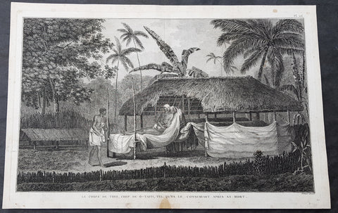
1785 Capt Cook Antique Print The Remains of Chief Vehiatua II (Tu) Tahiti, 1777
- Title : Le Corps De Thee, Chef De O Taiti, Tel Qu on le Conservoit Apres sa Mort. (The body of Thee, Chief of Tahiti Preserved after his death)
- Size: 16in x 10 1/2in (405mm x 265mm)
- Ref #: 21442
- Date : 1785
- Condition: (A+) Fine Condition
Description:
This fine original copper-plate engraved antique print of the mummified remains of Chief Vehiatua II (Tu), laying in state, on the island of Tahiti visited by Captain Cook in 1777, during his 3rd & last Voyage of Discovery, was engraved by Robert Benard - after John Webber - and was published in the 1785 French edition of Capt. James Cook & Capt. James King publication A Voyage to the Pacific Ocean. Undertaken, by the Command of his Majesty, for making Discoveries in the Northern Hemisphere. To determine The Position and Extent of the West Side of North America; its Distance from Asia; and the Practicability of a Northern Passage to Europe. Performed under the direction of Captains Cook, Clerke, and Gore, In His Majestys Ships the Resolution and Discovery. In the Years 1776, 1777, 1778, 1779, and 1780. In Three Volumes. Vol. I and II written by James Cook, F.R.S. Vol. III by Captain James King, LL.D. and F.R.S. Paris, 1785.
.....during his final visit, Cook returned Omai to Tahiti on 12 Aug. 1777, after Omais long visit in England. Cook also brought two Maori from Queen Charlotte Sound, Te Weherua and Koa. Cook first harbored in Vaitepiha Bay, where he visited Vehiatua IIs funeral bier and the prefabricated Spanish mission house. Cook also met Vehiatua III, and inscribed on the back of the Spanish cross, Georgius tertius Rex Annis 1767, 69, 73, 74 & 77, as a counterpoint to Christus Vincit Carolus III imperat 1774 on the front. On 23 Aug., Cook sailed for Matavai Bay, where he met Tu, his father Teu, his mother Tetupaia, his brothers Ariipaea and Vaetua, and his sisters Ariipaea-vahine, Tetua-te-ahamai, and Auo. Cook also observed a human sacrifice, taata tapu, at the Utu-ai-mahurau marae, and 49 skulls from previous victims....
General Definitions:
Paper thickness and quality: - Heavy and stable
Paper color : - off white
Age of map color: -
Colors used: -
General color appearance: -
Paper size: - 16in x 10 1/2in (405mm x 265mm)
Plate size: - 14 1/2in x 9 1/2in (370mm x 245mm)
Margins: - Min 1/2in (12mm)
Imperfections:
Margins: - Light soiling
Plate area: - None
Verso: - Light soiling
Background:
Tahiti previously also known as Otaheite is the largest island in the Windward group of French Polynesia. The island is located in the archipelago of the Society Islands in the central Southern Pacific Ocean.
The first European to have visited Tahiti according to existing records was lieutenant Samuel Wallis, who was circumnavigating the globe in HMS Dolphin, sighting the island on 18 June 1767, and eventually harboring in Matavai Bay. This bay was situated on the territory of the chiefdom of Pare-Arue, governed by Tu (Tu-nui-e-a a-i-te-Atua) and his regent Tutaha, and the chiefdom of Ha apape, governed by Amo and his wife Oberea (Purea). Wallis named the island King Georges Island. The first contacts were difficult, since on the 24 and 26 June 1767, Tahitian warriors in canoes showed aggression towards the British, hurling stones from their slings. In retaliation, the British sailors opened fire on the warriors in the canoes and on the hills. In reaction to this powerful counter-attack, the Tahitians laid down peace offerings for the British. Following this episode, Samuel Wallis was able to establish cordial relations with the female chieftain “Oberea “ (Purea) and remained on the island until 27 July 1767.
In July 1768, Captain James Cook was commissioned by the Royal Society and on orders from the Lords Commissioners of the Admiralty to observe the transit of Venus across the sun, a phenomenon that would be visible from Tahiti on 3 June 1769. He arrived in Tahitis Matavai Bay, commanding the HMS Endeavour on 12 April 1769. On 14 April, Cook met with Tutaha and Tepau. On 15 April, Cook picked the site for a fortified camp at Point Venus along with Banks, Parkinson, Daniel Solander, to protect Charles Greens observatory. The length of stay enabled them to undertake for the first time real ethnographic and scientific observations of the island. Assisted by the botanist Joseph Banks, and by the artist Sydney Parkinson, Cook gathered valuable information on the fauna and flora, as well as the native society, language and customs, including the proper name of the island, Otaheite. On 28 April, Cook met Purea and Tupaia, and Tupaia befriended Banks following the transit. On 21 June, Amo visited Cook, and then on 25 June, Pohuetea visited, signifying another chief seeking to ally himself with the British.
Cook and Banks circumnavigated the island from 26 June to 1 July. On the exploration, they met Ahio, chief of Ha apaiano o or Papenoo, Rita, chief of Hitia a, Pahairro, chief of Pueu, Vehiatua, chief of Tautra, Matahiapo, chief of Teahupo o, Tutea, chief of Vaira o, and Moe, chief of Afa Ahiti. In Papara, guided by Tupaia, they investigated the ruins of Mahaiatea marae, an impressive structure containing a stone pyramid or ahu, measuring 44 feet high, 267 feet long and 87 feet wide. Cook and the Endeavour departed Tahiti on 13 July 1769, taking Raiatean navigator Tupaia along for his geographic knowledge of the islands.
Cook returned to Tahiti between 15 August and 1 September 1773, greeted by the chiefs Tai and Puhi, besides the youg ari i Vehiatua II and his stepfather Ti itorea. Cook anchored in Vaitepiha Bay before returning to Point Venus where he met Tu, the paramount chief. Cook picked up two passengers from Tahiti during this trip, Porea and Mai, with Hitihiti later replacing Porea when Cook stopped at Raiatea. Cook took Hitihiti to Tahiti on 22 April, during his return leg. Then, Cook departed Tahiti on 14 May 1774.
During his final visit, Cook returned Mai to Tahiti on 12 Aug. 1777, after Mais long visit in England. Cook also brought two Maori from Queen Charlotte Sound, Te Weherua and Koa. Cook first harbored in Vaitepiha Bay, where he visited Vehiatua II s funeral bier and the prefabricated Spanish mission house. Cook also met Vehiatua III, and inscribed on the back of the Spanish cross, Georgius tertius Rex Annis 1767, 69, 73, 74 & 77, as a counterpoint to Christus Vincit Carolus III imperat 1774 on the front. On 23 Aug., Cook sailed for Matavai Bay, where he met Tu, his father Teu, his mother Tetupaia, his brothers Ari ipaea and Vaetua, and his sisters Ari ipaea-vahine, Tetua-te-ahamai, and Auo. Cook also observed a human sacrifice, taata tapu, at the Utu-ai-mahurau marae, and 49 skulls from previous victims.
On 29 Sept. 1777, Cook sailed for Papetoai Bay on Moorea. Cook met Mahine in an act of friendship on 3 Oct., though he was an enemy of Tu. When a goat kid was stolen on 6 Oct., Cook in a rampage, ordered the burning of houses and canoes until it was returned. Cook sailed for Huahine on 11 Oct., Raiatea on 2 Nov., and Borabora on 7 Dec.
On 26 October 1788, HMS Bounty, under the command of Captain William Bligh, landed in Tahiti with the mission of carrying Tahitian breadfruit trees (Tahitian: uru) to the Caribbean. Sir Joseph Banks, the botanist from James Cooks first expedition, had concluded that this plant would be ideal to feed the African slaves working in the Caribbean plantations at very little cost. The crew remained in Tahiti for about five months, the time needed to transplant the seedlings of the trees. Three weeks after leaving Tahiti, on 28 April 1789, the crew mutinied on the initiative of Fletcher Christian. The mutineers seized the ship and set the captain and most of those members of the crew who remained loyal to him adrift in a ships boat. A group of mutineers then went back to settle in Tahiti.
Although various explorers had refused to get involved in tribal conflicts, the mutineers from the Bounty offered their services as mercenaries and furnished arms to the family which became the Pōmare Dynasty. The chief Tū knew how to use their presence in the harbours favoured by sailors to his advantage. As a result of his alliance with the mutineers, he succeeded in considerably increasing his supremacy over the island of Tahiti.
Captain James King FRS 1750 – 1784 was an officer of the Royal Navy. He served under James Cook on his last voyage around the world, specialising in taking important astronomical readings using a sextant. After Cook died he helped lead the ships on the remainder of their course, also completing Cooks account of the voyage. He continued his career in the Navy, reaching the rank of post-captain, commanding several ships and serving in the American War of Independence.
King joined HMS Resolution as second lieutenant, sharing the duties of astronomer with Cook, taking astronomical observations on board by sextant and with Larcum Kendals timekeeper K1, to establish the Resolutions position at sea and on shore by sextant or by astronomical quadrant to establish the geographical position of salient points during the course of Cooks surveys. Thus Kings geographical positions were an important contribution to the accuracy of the various surveys carried out during the voyage and his use of the early chronometers helped prove their use at sea for calculation of Longitude. .
Following the death of Cook, King remained in the Resolution but on the death of Charles Clerke, Cooks successor, King was appointed to command HMS Discovery, the Resolutions consort, remaining in her for the rest of the voyage. After his return to England King was very much involved in the publication of the official account of Cooks third voyage, writing the third volume at Woodstock, near Oxford, where his brother Thomas was rector of St Mary Magdalene. But shortly after his return King was promoted Post-captain and appointed commander of HMS Crocodile in the English Channel.
John Webber RA 1751 – 1793 was an English artist who accompanied Captain Cook on his third Pacific expedition. He is best known for his images of Australasia, Hawaii and Alaska.
Webber was born in London, educated in Bern and studied painting at Paris.His father was Abraham Wäber, a Swiss sculptor who had moved to London, and changed his name to Webber before marrying a Mrs Mary Quant in 1744.
Webber served as official artist on James Cooks third voyage of discovery around the Pacific (1776–80) aboard HMS Resolution. At Adventure Bay in January 1777 he did drawings of A Man of Van Diemens Land and A Woman of Van Diemens Land. He also did many drawings of scenes in New Zealand and the South Sea islands. On this voyage, during which Cook lost his life in a fight in Hawaii, Webber became the first European artist to make contact with Hawaii, then called the Sandwich Islands. He made numerous watercolor landscapes of the islands of Kauai and Hawaii, and also portrayed many of the Hawaiian people.
In April 1778, Captain Cooks ships Resolution and Discovery anchored at Ship Cove, now known as Nootka Sound, Vancouver Island, Canada to refit. The crew took observations and recorded encounters with the local people. Webber made watercolour landscapes including Resolution and Discovery in Ship Cove, 1778. His drawings and paintings were engraved for British Admiraltys account of the expedition, which was published in 1784.
Back in England in 1780 Webber exhibited around 50 works at Royal Academy exhibitions between 1784 and 1792, and was elected an associate of the Royal Academy in 1785 and R.A. in 1791. Most of his work were landscapes. Sometimes figures were included as in A Party from H.M.S. Resolution shooting sea horses, which was shown at the academy in 1784, and his The Death of Captain Cook became well known through an engraving of it. Another version of this picture is in the William Dixson gallery at Sydney
Robert Bénard 1734 – 1777 was an 18th-century French engraver.
Specialized in the technique of engraving, Robert Ménard is mainly famous for having supplied a significant amount of plates (at least 1,800) to the Encyclopédie by Diderot & d Alembert from 1751.
Later, publisher Charles-Joseph Panckoucke reused many of his productions to illustrate the works of his catalog.
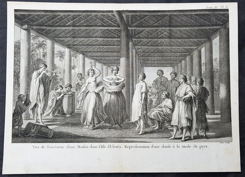
1785 Capt Cook Antique Print of Dancing Girls & Musicians Raiatea Island in 1777
- Title : Vue d L Interieur d une Maison dans i Isle d Ulietea. Representation d une danse a la mode du pays. (View of the inside a house in Isle of Ulieteai. Representation of a dance of the fashion of the country)
- Size: 14 1/2in x 9 1/2in (370mm x 245mm)
- Ref #: 16087
- Date : 1785
- Condition: (A+) Fine Condition
Description:
This fine original copper-plate engraved antique print of te interior of a long house, dancing girls and musicians on the Island of Raiatea (Ulietea) part of French Polynesia, visited by Captain Cook in 1777, during his 3rd & last Voyage of Discovery, was engraved by Robert Benard - after John Webber - and was published in the 1785 French edition of Capt. James Cook & Capt. James King publication A Voyage to the Pacific Ocean. Undertaken, by the Command of his Majesty, for making Discoveries in the Northern Hemisphere. To determine The Position and Extent of the West Side of North America; its Distance from Asia; and the Practicability of a Northern Passage to Europe. Performed under the direction of Captains Cook, Clerke, and Gore, In His Majestys Ships the Resolution and Discovery. In the Years 1776, 1777, 1778, 1779, and 1780. In Three Volumes. Vol. I and II written by James Cook, F.R.S. Vol. III by Captain James King, LL.D. and F.R.S. Paris, 1785.
Cooks Journal 1777
Sep. 29 Mon. Sails for Moorea (Eimeo).
30 Tue. Anchors at Tareu/Papetaai, Moorea.
Oct. 11 Sat. Sails for Fare, Huahine.
12 Sun. Lands at Fare and installs Omai ashore, builds house and plantation.
Nov. 2 Sun. Sails for Raiatea.
3 Mon. Anchors at Haamanino (also in July 1768 and May 1774). Sets up Observatory.
Dec. 8 Mon. Stands off Borabora but stands off and heads MS.
22 Mon. Crosses the Equator.
24 Wed. Sights Christmas Island. Anchors in atoll and collects turtles.
30 Tue. Observes eclipse of Sun (Cook Islet/Eclipse Island).
General Definitions:
Paper thickness and quality: - Heavy and stable
Paper color : - off white
Age of map color: -
Colors used: -
General color appearance: -
Paper size: - 14 1/2in x 9 1/2in (370mm x 245mm)
Plate size: - 14 1/2in x 9 1/2in (370mm x 245mm)
Margins: - Min 1/2in (12mm)
Imperfections:
Margins: - Light soiling
Plate area: - None
Verso: - Light soiling
Background:
Raiatea, is the second largest of the Society Islands, after Tahiti, in French Polynesia. The island is widely regarded as the centre of the eastern islands in ancient Polynesia and it is likely that the organised migrations to Hawaii, Aotearoa and other parts of East Polynesia started at Raiātea.
A traditional name for the island is Havaii, homeland of the Māori people.
The first European to record sighting Ra\\\\\\\'iātea was Pedro Fernandes de Queirós in 1606; it was charted as La Fugitiva The Polynesian navigator, Tupaia, who sailed with explorer James Cook, was born in Ra\\\\\\\'iātea around 1725.
Cook visited Raiatea in 1769 and again in 1773-1774. Omai (c.1751-1780), another young man from Raiātea, traveled with the European explorers to London in 1774 and also served as an interpreter to Captain Cook on his second and third journey.
King Tamatoa VI was the last monarch, reigning from 1884-1888.
Captain James King FRS 1750 – 1784 was an officer of the Royal Navy. He served under James Cook on his last voyage around the world, specialising in taking important astronomical readings using a sextant. After Cook died he helped lead the ships on the remainder of their course, also completing Cooks account of the voyage. He continued his career in the Navy, reaching the rank of post-captain, commanding several ships and serving in the American War of Independence.
King joined HMS Resolution as second lieutenant, sharing the duties of astronomer with Cook, taking astronomical observations on board by sextant and with Larcum Kendals timekeeper K1, to establish the Resolutions position at sea and on shore by sextant or by astronomical quadrant to establish the geographical position of salient points during the course of Cooks surveys. Thus Kings geographical positions were an important contribution to the accuracy of the various surveys carried out during the voyage and his use of the early chronometers helped prove their use at sea for calculation of Longitude. .
Following the death of Cook, King remained in the Resolution but on the death of Charles Clerke, Cooks successor, King was appointed to command HMS Discovery, the Resolutions consort, remaining in her for the rest of the voyage. After his return to England King was very much involved in the publication of the official account of Cooks third voyage, writing the third volume at Woodstock, near Oxford, where his brother Thomas was rector of St Mary Magdalene. But shortly after his return King was promoted Post-captain and appointed commander of HMS Crocodile in the English Channel.
John Webber RA 1751 – 1793 was an English artist who accompanied Captain Cook on his third Pacific expedition. He is best known for his images of Australasia, Hawaii and Alaska.
Webber was born in London, educated in Bern and studied painting at Paris.His father was Abraham Wäber, a Swiss sculptor who had moved to London, and changed his name to Webber before marrying a Mrs Mary Quant in 1744.
Webber served as official artist on James Cooks third voyage of discovery around the Pacific (1776–80) aboard HMS Resolution. At Adventure Bay in January 1777 he did drawings of A Man of Van Diemens Land and A Woman of Van Diemens Land. He also did many drawings of scenes in New Zealand and the South Sea islands. On this voyage, during which Cook lost his life in a fight in Hawaii, Webber became the first European artist to make contact with Hawaii, then called the Sandwich Islands. He made numerous watercolor landscapes of the islands of Kauai and Hawaii, and also portrayed many of the Hawaiian people.
In April 1778, Captain Cooks ships Resolution and Discovery anchored at Ship Cove, now known as Nootka Sound, Vancouver Island, Canada to refit. The crew took observations and recorded encounters with the local people. Webber made watercolour landscapes including Resolution and Discovery in Ship Cove, 1778. His drawings and paintings were engraved for British Admiraltys account of the expedition, which was published in 1784.
Back in England in 1780 Webber exhibited around 50 works at Royal Academy exhibitions between 1784 and 1792, and was elected an associate of the Royal Academy in 1785 and R.A. in 1791. Most of his work were landscapes. Sometimes figures were included as in A Party from H.M.S. Resolution shooting sea horses, which was shown at the academy in 1784, and his The Death of Captain Cook became well known through an engraving of it. Another version of this picture is in the William Dixson gallery at Sydney
Robert Bénard 1734 – 1777 was an 18th-century French engraver.
Specialized in the technique of engraving, Robert Ménard is mainly famous for having supplied a significant amount of plates (at least 1,800) to the Encyclopédie by Diderot & d Alembert from 1751.
Later, publisher Charles-Joseph Panckoucke reused many of his productions to illustrate the works of his catalog.
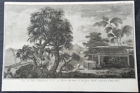
1778 Capt Cook Antique Print Huahine Island, French Polynesia Manao Tupapa, 1773
- Title : Vue d de L Isle d Huaheine avec la Maison de Dieu, et un petit Autel couvert d offrandes. (View of the Island of Huaheine with the House of God, and a small covered altar with offerings)
- Size: 14 1/2in x 9 1/2in (370mm x 245mm)
- Ref #: 21590
- Date : 1778
- Condition: (A+) Fine Condition
Description:
This large original copper-plate engraved antique print a view of the Island of Huahine, near Tahiti and a local shrine and the practice of the Spirit of the Dead Watching (Manao tupapau), visited by Captain James Cook in 1773, during his 2nd Voyage of Discovery to the South Seas, was engraved by Robert Benard - after William Hodges - and was published in the 1778 French edition of Capt. James Cooks 2nd Voyage of Discovery to the South Seas A voyage towards the South Pole, and round the World. Performed in His Majestys ships the Resolution and Adventure, in the years 1772, 1773, 1774, and 1775..... Paris : Hotel de Thou ......1778.
Ghosts in Polynesian culture
There was widespread belief in ghosts in Polynesian culture, some of which persists today. After death, a person\'s ghost would normally travel to the sky world or the underworld, but some could stay on earth. In many Polynesian legends, ghosts were often involved in the affairs of the living. Ghosts might also cause sickness or even invade the body of ordinary people, to be driven out through strong medicines.
In the reconstructed Proto-Polynesian language, the word qaitu refers to a ghost, the spirit of a dead person, while the word tupuqa has a broader meaning including all supernatural beings. Some of the ancient Māui legends that are common throughout the Polynesian islands include the idea of a double soul inhabiting the body. One was the soul which never forsakes man, and the other the soul that could be separated or charmed away from the body by incantations was the hau.
In some societies, the tattoo marks on the Polynesian\'s face indicated their cult. A spiral symbol meant that the man favoured the sky world, but before ascending there on a whirlwind his ghost had to travel to his people\'s homeland, situated in the navel of the world. Different markings indicated that the ghost chose to live in the underworld. The Hawaiians believed in aumakua, ghosts who did not go down into Po, the land of King Milu. These ghosts remained in the land of the living, guarding their former families.
Of his 1892 Tahitian painting Manao Tupapau, Paul Gauguin said according to Tahitian beliefs, the title Manao Tupapau has a double meaning . . . either she thinks of the ghost or the ghost thinks of her.
General Definitions:
Paper thickness and quality: - Heavy and stable
Paper color : - off white
Age of map color: -
Colors used: -
General color appearance: -
Paper size: - 14 1/2in x 9 1/2in (370mm x 245mm)
Plate size: - 14 1/2in x 9 1/2in (370mm x 245mm)
Margins: - Min 1/2in (12mm)
Imperfections:
Margins: - None
Plate area: - None
Verso: - None
Background:
Huahine is an island located among the Society Islands, in French Polynesia, an overseas territory of France in the Pacific Ocean. It is part of the Leeward Islands group (Iles sous le Vent).
Captain Cook arrived Fare Harbour on 16 July 1769, with Tupaia navigating the HMS Endeavour. They met with leading chief Ori (Mato). Cook returned on 3 Sept. 1773 and met with Oris son Teri itaria, the new ari i rahi of the island.
William Hodges RA 1744 – 1797 was an English painter. He was a member of James Cooks second voyage to the Pacific Ocean, and is best known for the sketches and paintings of locations he visited on that voyage, including Table Bay, Tahiti, Easter Island, and the Antarctic.
Between 1772 and 1775 Hodges accompanied James Cook to the Pacific as the expeditions artist. Many of his sketches and wash paintings were adapted as engravings in the original published edition of Cooks journals from the voyage.
Most of the large-scale landscape oil paintings from his Pacific travels for which Hodges is best known were finished after his return to London; he received a salary from the Admiralty for the purposes of completing them. These paintings depicted a stronger light and shadow than had been usual in European landscape tradition. Contemporary art critics complained that his use of light and colour contrasts gave his paintings a rough and unfinished appearance.
Hodges also produced many valuable portrait sketches of Pacific islanders and scenes from the voyage involving members of the expedition..
Robert Bénard 1734 – 1777 was an 18th-century French engraver.
Specialized in the technique of engraving, Robert Ménard is mainly famous for having supplied a significant amount of plates (at least 1,800) to the Encyclopédie by Diderot & d\'Alembert from 1751.
Later, publisher Charles-Joseph Panckoucke reused many of his productions to illustrate the works of his catalog.
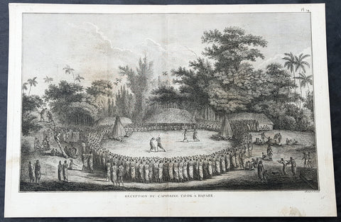
1785 Capt Cook Antique Print Cook Reception on Lifuka Island, Haapai Tonga, 1777
- Title : Reception Du Capitaine Cook a Hapaee (Reception for Captain Cook in Hapaee)
- Size: 15 1/2in x 10 1/2in (395mm x 265mm)
- Ref #: 21437
- Date : 1785
- Condition: (A+) Fine Condition
Description:
This fine original copper-plate engraved antique print of the reception for Captain Cook on the island of Lifuka, one of the islands of the Haapai group of Tonga Islands, visited by Captain Cook in 1777, during his 3rd & last Voyage of Discovery, was engraved by Robert Benard - after John Webber - and was published in the 1785 French edition of Capt. James Cook & Capt. James King publication A Voyage to the Pacific Ocean. Undertaken, by the Command of his Majesty, for making Discoveries in the Northern Hemisphere. To determine The Position and Extent of the West Side of North America; its Distance from Asia; and the Practicability of a Northern Passage to Europe. Performed under the direction of Captains Cook, Clerke, and Gore, In His Majestys Ships the Resolution and Discovery. In the Years 1776, 1777, 1778, 1779, and 1780. In Three Volumes. Vol. I and II written by James Cook, F.R.S. Vol. III by Captain James King, LL.D. and F.R.S. Paris, 1785.
Captain Cook seated with the chiefs, watching two pairs of combatants, one pair boxing, the other pair fighting with clubs within a large circle of spectators. Some men of Cook\'s company are on the left on the fringe of the crowd.
............presently after a number of men entered the Circle or Area before us, armed with Clubs made of the green branches of the Cocoanut tree, these paraded about for a few minutes and then retired the one half to one side and the other half to the other, and seated themselves before the spectators: but soon after went to single Combat, one or two steping forward from the one side and chalenging those on the other which was done more by actions than words; if the Challenge was expected, which was generally the case, each put himself in a proper attitude and began to engage and continued till one or the other gave out or their weapons were broke….there were Wristling and Boxing matches; the first were performed in the same m[an]ner as at Otahiete, and the second very little different from the method practiced in England. Cook Journals III, i, 107
General Definitions:
Paper thickness and quality: - Heavy and stable
Paper color : - off white
Age of map color: -
Colors used: -
General color appearance: -
Paper size: - 15 1/2in x 10 1/2in (395mm x 265mm)
Plate size: - 14 1/2in x 9 1/2in (370mm x 245mm)
Margins: - Min 1/2in (12mm)
Imperfections:
Margins: - Light soiling
Plate area: - None
Verso: - Light soiling
Background:
Lifuka is an island in the Kingdom of Tonga. It is located within the Haapai Group in the centre of the country, to northeast of the national capital of Nukualofa.
Lifuka is the place where Captain James Cook dubbed Tonga The Friendly Islands. Tofua is where the mutiny on the Bounty occurred in 1789; this active volcanic island lies approximately forty nautical miles west of Lifuka. The Cpt. Bligh voyage stands as the longest successful passage ever recorded in an open boat without modern navigational aids.
Haapai is a group of islands, islets, reefs and shoals with an area of 109.30 square kilometres in the central part of the Kingdom of Tonga, with the Tongatapu group to the south and the Vavau group to the north. Seventeen of the Ha apai islands are populated with altogether 6,616 people.
The first European to visit Ha apai, was Abel Tasman in 1643. Captain James Cook in 1774 and 1777, made several stops on the islands. He gave them the name of Friendly Islands in 1777.
On 18 May 1777, Cook arrived with Omai. They were greeted by Fatafehi Paulaho, King of the Isles or Tui Tonga, the most sacred chief in these islands.
Tonga officially the Kingdom of Tonga, is a Polynesian sovereign state and archipelago comprising 169 islands, of which 36 are inhabited. The total surface area is about 750 square kilometres (290 sq mi) scattered over 700,000 square kilometres (270,000 sq mi) of the southern Pacific Ocean. It has a population of 107,122 people, of whom 70% reside on the main island of Tongatapu.
The Tongan people first encountered Europeans in 1616 when the Dutch vessel Eendracht, captained by Willem Schouten, made a short visit to trade. Later came other Dutch explorers, including Jacob Le Maire (who called on the northern island of Niuatoputapu); and in 1643 Abel Tasman (who visited Tongatapu and Haapai).
Later noteworthy European visitors included James Cook (Royal Navy) in 1773, 1774, and 1777; Alessandro Malaspina (Spanish Navy) in 1793; the first London missionaries in 1797; and the Wesleyan Methodist Reverend Walter Lawry in 1822.
Tonga became known in the West as the Friendly Islands because of the congenial reception accorded to Captain James Cook on his first visit in 1773. He arrived at the time of the inasi festival, the yearly donation of the First Fruits to the Tui Tonga (the islands paramount chief) and so received an invitation to the festivities. According to the writer William Mariner, the chiefs wanted to kill Cook during the gathering but could not agree on a plan.
Captain James King FRS 1750 – 1784 was an officer of the Royal Navy. He served under James Cook on his last voyage around the world, specialising in taking important astronomical readings using a sextant. After Cook died he helped lead the ships on the remainder of their course, also completing Cooks account of the voyage. He continued his career in the Navy, reaching the rank of post-captain, commanding several ships and serving in the American War of Independence.
King joined HMS Resolution as second lieutenant, sharing the duties of astronomer with Cook, taking astronomical observations on board by sextant and with Larcum Kendals timekeeper K1, to establish the Resolutions position at sea and on shore by sextant or by astronomical quadrant to establish the geographical position of salient points during the course of Cooks surveys. Thus Kings geographical positions were an important contribution to the accuracy of the various surveys carried out during the voyage and his use of the early chronometers helped prove their use at sea for calculation of Longitude. .
Following the death of Cook, King remained in the Resolution but on the death of Charles Clerke, Cooks successor, King was appointed to command HMS Discovery, the Resolutions consort, remaining in her for the rest of the voyage. After his return to England King was very much involved in the publication of the official account of Cooks third voyage, writing the third volume at Woodstock, near Oxford, where his brother Thomas was rector of St Mary Magdalene. But shortly after his return King was promoted Post-captain and appointed commander of HMS Crocodile in the English Channel.
John Webber RA 1751 – 1793 was an English artist who accompanied Captain Cook on his third Pacific expedition. He is best known for his images of Australasia, Hawaii and Alaska.
Webber was born in London, educated in Bern and studied painting at Paris.His father was Abraham Wäber, a Swiss sculptor who had moved to London, and changed his name to Webber before marrying a Mrs Mary Quant in 1744.
Webber served as official artist on James Cooks third voyage of discovery around the Pacific (1776–80) aboard HMS Resolution. At Adventure Bay in January 1777 he did drawings of A Man of Van Diemens Land and A Woman of Van Diemens Land. He also did many drawings of scenes in New Zealand and the South Sea islands. On this voyage, during which Cook lost his life in a fight in Hawaii, Webber became the first European artist to make contact with Hawaii, then called the Sandwich Islands. He made numerous watercolor landscapes of the islands of Kauai and Hawaii, and also portrayed many of the Hawaiian people.
In April 1778, Captain Cooks ships Resolution and Discovery anchored at Ship Cove, now known as Nootka Sound, Vancouver Island, Canada to refit. The crew took observations and recorded encounters with the local people. Webber made watercolour landscapes including Resolution and Discovery in Ship Cove, 1778. His drawings and paintings were engraved for British Admiraltys account of the expedition, which was published in 1784.
Back in England in 1780 Webber exhibited around 50 works at Royal Academy exhibitions between 1784 and 1792, and was elected an associate of the Royal Academy in 1785 and R.A. in 1791. Most of his work were landscapes. Sometimes figures were included as in A Party from H.M.S. Resolution shooting sea horses, which was shown at the academy in 1784, and his The Death of Captain Cook became well known through an engraving of it. Another version of this picture is in the William Dixson gallery at Sydney
Robert Bénard 1734 – 1777 was an 18th-century French engraver.
Specialized in the technique of engraving, Robert Ménard is mainly famous for having supplied a significant amount of plates (at least 1,800) to the Encyclopédie by Diderot & d Alembert from 1751.
Later, publisher Charles-Joseph Panckoucke reused many of his productions to illustrate the works of his catalog.
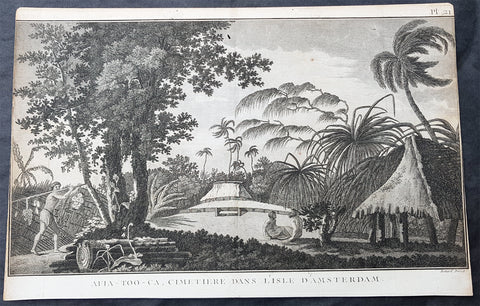
1785 Capt Cook Antique Print View of Tongatapu Tonga Burial Mounds or Langi 1777
- Title : Afia-Too-Ca, Cimetiere Dans L Isle D Amsterdam (AFIA-Too-Ca, cemetery in L Isle D Amsterdam)
- Size: 14 1/2in x 9 1/2in (370mm x 245mm)
- Ref #: 31833
- Date : 1785
- Condition: (A) Very Good Condition
Description:
This fine original copper-plate engraved antique print of the burial mounds or Langi, Tomb Hills in the town of Mua on the main Tongan Island of Tongatapu (named Amsterdam by Willem Schouten in 1616) visited by Captain Cook in 1777, during his 3rd & last Voyage of Discovery, was engraved by Robert Benard - after John Webber - and was published in the 1785 French edition of Capt. James Cook & Capt. James King publication A Voyage to the Pacific Ocean. Undertaken, by the Command of his Majesty, for making Discoveries in the Northern Hemisphere. To determine The Position and Extent of the West Side of North America; its Distance from Asia; and the Practicability of a Northern Passage to Europe. Performed under the direction of Captains Cook, Clerke, and Gore, In His Majestys Ships the Resolution and Discovery. In the Years 1776, 1777, 1778, 1779, and 1780. In Three Volumes. Vol. I and II written by James Cook, F.R.S. Vol. III by Captain James King, LL.D. and F.R.S. Paris, 1785.
General Definitions:
Paper thickness and quality: - Heavy and stable
Paper color : - off white
Age of map color: -
Colors used: -
General color appearance: -
Paper size: - 15 1/2in x 10in (390mm x 255mm)
Plate size: - 14 1/2in x 9 1/2in (370mm x 245mm)
Margins: - Min 1/2in (12mm)
Imperfections:
Margins: - Light soiling
Plate area: - None
Verso: - Light soiling
Background:
Mua is a small town in the Hahake (eastern) district on the island of Tongatapu, and it was for centuries the ancient capital of Tonga. It is divided in the villages Lapaha and Tatakamotonga, is close to Talasiu and famous for the ancient langi (royal burial tombs).
Muʻa was at one time the center of Lapita culture in Tonga (about 2,000 years ago) and later (twelfth to sixteenth century CE) the capital of the Tuʻi Tonga Empire. After the disintegration of the empire it remained the capital of the Tui Tonga (Tonga kings), up to the nineteenth century, but was rather a spiritual centre and no longer a source of political power.
The Tui Tonga and his retinue stayed in Lapaha, his residence being Olotele and Ahofakasiu, while Takuilau was for his wives. Subchiefs and servants on the other hand lived in Tatakamotonga.
When, around 1470, the Tui Tonga line started to lose power to the Tui Ha atakalaua, and another century later to the Tu i Kanokupolu, chiefs belonging to these lines were not welcome in Mu a, and had to stay on the low-lying coastal areas, separated from the real chiefs (i.e. those belonging to the Tu i Tonga) by the Hala Fonuamoa (dry land road). The former became known as the kauhalalalo (low road people) and the latter as the kauhala uta (inland road people), which nowadays are still two important moieties in Tonga.
Whatever political power the Tu i Tonga yielded to their rivals, they gained in spiritual power, and as a kind of high priest they were perhaps even more awesome than as kings. When a Tu i Tonga died he was buried in one of the huge tomb hills, known as langi, of which there are still at least two dozen in Lapaha. The Tu i Haʻatakalaua were also buried in such tombs, but they are called fale instead.
The langi are big, artificial hills surrounded by huge slabs of coral rock, usually in three or more tiered layers. These slabs were quarried from several places along the coast of Tongatapu or neighbouring minor islands. The waves of the sea made them over the centuries, by compacting coral sand into layers of 10 to 20 centimetres (3.9 to 7.9 inches) thick. They were only to be dug out and then transported by boat to the building site. Nevertheless, the accuracy by which the slabs were cut to shape so that they fit along each other with barely any space to spare is remarkable.
One of the best-preserved langi is the Paepae-o-Tele a, which is even more remarkable as the slabs along the corner really have an L shape.
The story that the slabs were moved by magic means from Uvea to Tonga is just a myth. Uvea is volcanic and has not got the proper geology. This fact has always been known, as shown, for example by a stanza of the poem named Laveofo from around the 18th century by Tufui.
Haapai is a group of islands, islets, reefs and shoals with an area of 109.30 square kilometres in the central part of the Kingdom of Tonga, with the Tongatapu group to the south and the Vavau group to the north. Seventeen of the Ha apai islands are populated with altogether 6,616 people.
The first European to visit Ha apai, was Abel Tasman in 1643. Captain James Cook in 1774 and 1777, made several stops on the islands. He gave them the name of Friendly Islands in 1777.
On 18 May 1777, Cook arrived with Omai. They were greeted by Fatafehi Paulaho, King of the Isles or Tui Tonga, the most sacred chief in these islands.
Tonga officially the Kingdom of Tonga, is a Polynesian sovereign state and archipelago comprising 169 islands, of which 36 are inhabited. The total surface area is about 750 square kilometres (290 sq mi) scattered over 700,000 square kilometres (270,000 sq mi) of the southern Pacific Ocean. It has a population of 107,122 people, of whom 70% reside on the main island of Tongatapu.
The Tongan people first encountered Europeans in 1616 when the Dutch vessel Eendracht, captained by Willem Schouten, made a short visit to trade. Later came other Dutch explorers, including Jacob Le Maire (who called on the northern island of Niuatoputapu); and in 1643 Abel Tasman (who visited Tongatapu and Haapai).
Later noteworthy European visitors included James Cook (Royal Navy) in 1773, 1774, and 1777; Alessandro Malaspina (Spanish Navy) in 1793; the first London missionaries in 1797; and the Wesleyan Methodist Reverend Walter Lawry in 1822.
Tonga became known in the West as the Friendly Islands because of the congenial reception accorded to Captain James Cook on his first visit in 1773. He arrived at the time of the inasi festival, the yearly donation of the First Fruits to the Tui Tonga (the islands paramount chief) and so received an invitation to the festivities. According to the writer William Mariner, the chiefs wanted to kill Cook during the gathering but could not agree on a plan.
Captain James King FRS 1750 – 1784 was an officer of the Royal Navy. He served under James Cook on his last voyage around the world, specialising in taking important astronomical readings using a sextant. After Cook died he helped lead the ships on the remainder of their course, also completing Cooks account of the voyage. He continued his career in the Navy, reaching the rank of post-captain, commanding several ships and serving in the American War of Independence.
King joined HMS Resolution as second lieutenant, sharing the duties of astronomer with Cook, taking astronomical observations on board by sextant and with Larcum Kendals timekeeper K1, to establish the Resolutions position at sea and on shore by sextant or by astronomical quadrant to establish the geographical position of salient points during the course of Cooks surveys. Thus Kings geographical positions were an important contribution to the accuracy of the various surveys carried out during the voyage and his use of the early chronometers helped prove their use at sea for calculation of Longitude. .
Following the death of Cook, King remained in the Resolution but on the death of Charles Clerke, Cooks successor, King was appointed to command HMS Discovery, the Resolutions consort, remaining in her for the rest of the voyage. After his return to England King was very much involved in the publication of the official account of Cooks third voyage, writing the third volume at Woodstock, near Oxford, where his brother Thomas was rector of St Mary Magdalene. But shortly after his return King was promoted Post-captain and appointed commander of HMS Crocodile in the English Channel.
John Webber RA 1751 – 1793 was an English artist who accompanied Captain Cook on his third Pacific expedition. He is best known for his images of Australasia, Hawaii and Alaska.
Webber was born in London, educated in Bern and studied painting at Paris.His father was Abraham Wäber, a Swiss sculptor who had moved to London, and changed his name to Webber before marrying a Mrs Mary Quant in 1744.
Webber served as official artist on James Cooks third voyage of discovery around the Pacific (1776–80) aboard HMS Resolution. At Adventure Bay in January 1777 he did drawings of A Man of Van Diemens Land and A Woman of Van Diemens Land. He also did many drawings of scenes in New Zealand and the South Sea islands. On this voyage, during which Cook lost his life in a fight in Hawaii, Webber became the first European artist to make contact with Hawaii, then called the Sandwich Islands. He made numerous watercolor landscapes of the islands of Kauai and Hawaii, and also portrayed many of the Hawaiian people.
In April 1778, Captain Cooks ships Resolution and Discovery anchored at Ship Cove, now known as Nootka Sound, Vancouver Island, Canada to refit. The crew took observations and recorded encounters with the local people. Webber made watercolour landscapes including Resolution and Discovery in Ship Cove, 1778. His drawings and paintings were engraved for British Admiraltys account of the expedition, which was published in 1784.
Back in England in 1780 Webber exhibited around 50 works at Royal Academy exhibitions between 1784 and 1792, and was elected an associate of the Royal Academy in 1785 and R.A. in 1791. Most of his work were landscapes. Sometimes figures were included as in A Party from H.M.S. Resolution shooting sea horses, which was shown at the academy in 1784, and his The Death of Captain Cook became well known through an engraving of it. Another version of this picture is in the William Dixson gallery at Sydney
Robert Bénard 1734 – 1777 was an 18th-century French engraver.
Specialized in the technique of engraving, Robert Ménard is mainly famous for having supplied a significant amount of plates (at least 1,800) to the Encyclopédie by Diderot & d Alembert from 1751.
Later, publisher Charles-Joseph Panckoucke reused many of his productions to illustrate the works of his catalog.
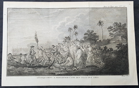
1778 Capt Cook Antique Print of Capt Cook Landing on Eua Island, Tonga in 1773
- Title : Debarquement A Middelburgh L une des Amis (Landing A Middelburgh one of the Friendly Islands)
- Size: 12in x 8in (305mm x 205mm)
- Ref #: 21357
- Date : 1778
- Condition: (A+) Fine Condition
Description:
This large original copper-plate engraved antique print of Captain Cook landing on the Island of Eua - with HMS Resolution in the background - (named Middelburg by the Dutch explorer Abel Tasman in 1643) a small island close the the main island of Tongatapu, in the Kingdom of Tonga, visited by Captain James Cook in 1773, during his 2nd Voyage of Discovery to the South Seas, was engraved by Robert Benard - after William Hodges - and was published in the 1778 French edition of Capt. James Cooks 2nd Voyage of Discovery to the South Seas A voyage towards the South Pole, and round the World. Performed in His Majestys ships the Resolution and Adventure, in the years 1772, 1773, 1774, and 1775..... Paris : Hotel de Thou ......1778.
As it was, Cook did not encounter the Tongan islands until his Second Voyage, when he stopped at both \'Eua and Tongatapu (or, by Tasman\'s nomenclature, Middleburg and Amsterdam respectively) in October of 1773. Here he was welcomed a shore by acclamations from an immence [sic] crowd of Men and Women not one of which had so much as a stick in their hands.
Indeed, Cook found the islanders to be so accommodating that he returned to the archipelago in 1774 on his way back from New Zealand. Stopping at the island of Nomuka, Cook was sought out by name, and with this proof that these people have a communication with Amsterdam, the cultural unity of the islands was established.
It was at this time that he famously named the island group the Friendly Archipelago, as a lasting friendship seems to subsist among the Inhabitants and their Courtesy to Strangers intitles [sic] them to that Name.
Cooks Third Voyage also included a visit to Tonga, this time for a stay of several months. Cook first dropped anchor at Nomuka in May, and then, at the invitation of the great chief Finau, travelled to another island, Lifuka. Here, Cook and his men were treated to such entertainments as whould [sic] have met with universal applause on a European Theatre.
General Definitions:
Paper thickness and quality: - Heavy and stable
Paper color : - off white
Age of map color: -
Colors used: -
General color appearance: -
Paper size: - 12in x 8in (305mm x 205mm)
Plate size: - 11 1/2in x 7in (295mm x 180mm)
Margins: - Min 1/2in (12mm)
Imperfections:
Margins: - None
Plate area: - Folds as issued
Verso: - None
Background:
Eua is a smaller but still major island in the kingdom of Tonga. It is close to Tongatapu, but forms a separate administrative division
Eua was put on the European maps by Abel Tasman who reached it and Tongatapu on 21 January 1643. He called it Middelburg Island, after the capital of the Dutch province of Zeeland. He did not go on land, but proceeded to the Hihifo district of Tongatapu, which he named Amsterdam Island after the capital of the Netherlands.
Tonga officially the Kingdom of Tonga, is a Polynesian sovereign state and archipelago comprising 169 islands, of which 36 are inhabited. The total surface area is about 750 square kilometres (290 sq mi) scattered over 700,000 square kilometres (270,000 sq mi) of the southern Pacific Ocean. It has a population of 107,122 people, of whom 70% reside on the main island of Tongatapu.
The Tongan people first encountered Europeans in 1616 when the Dutch vessel Eendracht, captained by Willem Schouten, made a short visit to trade. Later came other Dutch explorers, including Jacob Le Maire (who called on the northern island of Niuatoputapu); and in 1643 Abel Tasman (who visited Tongatapu and Haapai).
Later noteworthy European visitors included James Cook (Royal Navy) in 1773, 1774, and 1777; Alessandro Malaspina (Spanish Navy) in 1793; the first London missionaries in 1797; and the Wesleyan Methodist Reverend Walter Lawry in 1822.
Tonga became known in the West as the Friendly Islands because of the congenial reception accorded to Captain James Cook on his first visit in 1773. He arrived at the time of the inasi festival, the yearly donation of the First Fruits to the Tui Tonga (the islands paramount chief) and so received an invitation to the festivities. According to the writer William Mariner, the chiefs wanted to kill Cook during the gathering but could not agree on a plan.
William Hodges RA 1744 – 1797 was an English painter. He was a member of James Cooks second voyage to the Pacific Ocean, and is best known for the sketches and paintings of locations he visited on that voyage, including Table Bay, Tahiti, Easter Island, and the Antarctic.
Between 1772 and 1775 Hodges accompanied James Cook to the Pacific as the expeditions artist. Many of his sketches and wash paintings were adapted as engravings in the original published edition of Cooks journals from the voyage.
Most of the large-scale landscape oil paintings from his Pacific travels for which Hodges is best known were finished after his return to London; he received a salary from the Admiralty for the purposes of completing them. These paintings depicted a stronger light and shadow than had been usual in European landscape tradition. Contemporary art critics complained that his use of light and colour contrasts gave his paintings a rough and unfinished appearance.
Hodges also produced many valuable portrait sketches of Pacific islanders and scenes from the voyage involving members of the expedition..
Robert Bénard 1734 – 1777 was an 18th-century French engraver.
Specialized in the technique of engraving, Robert Ménard is mainly famous for having supplied a significant amount of plates (at least 1,800) to the Encyclopédie by Diderot & d\'Alembert from 1751.
Later, publisher Charles-Joseph Panckoucke reused many of his productions to illustrate the works of his catalog.
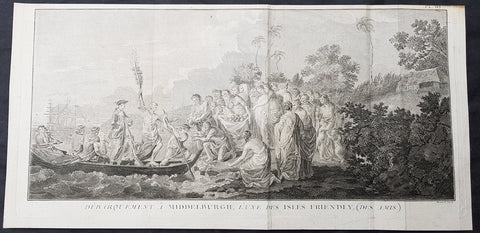
1778 Capt Cook Antique Print of Capt Cook Landing on Eua Island, Tonga in 1773
- Title : Debarquement A Middelburgh L une des Isles Friendly, (Des Amis) (Landing A Middelburgh one of the Friendly Isles, (friends)
- Size: 20in x 9 1/2in (510mm x 245mm)
- Ref #: 21497
- Date : 1778
- Condition: (A) Very Good Condition
Description:
This large original copper-plate engraved antique print of Captain Cook landing on the Island of Eua - with HMS Resolution in the background - (named Middelburg by the Dutch explorer Abel Tasman in 1643) a small island close the the main island of Tongatapu, in the Kingdom of Tonga, visited by Captain James Cook in 1773, during his 2nd Voyage of Discovery to the South Seas, was engraved by Robert Benard - after William Hodges - and was published in the 1778 French edition of Capt. James Cooks 2nd Voyage of Discovery to the South Seas A voyage towards the South Pole, and round the World. Performed in His Majestys ships the Resolution and Adventure, in the years 1772, 1773, 1774, and 1775..... Paris : Hotel de Thou ......1778.
As it was, Cook did not encounter the Tongan islands until his Second Voyage, when he stopped at both \'Eua and Tongatapu (or, by Tasman\'s nomenclature, Middleburg and Amsterdam respectively) in October of 1773. Here he was welcomed a shore by acclamations from an immence [sic] crowd of Men and Women not one of which had so much as a stick in their hands.
Indeed, Cook found the islanders to be so accommodating that he returned to the archipelago in 1774 on his way back from New Zealand. Stopping at the island of Nomuka, Cook was sought out by name, and with this proof that these people have a communication with Amsterdam, the cultural unity of the islands was established.
It was at this time that he famously named the island group the Friendly Archipelago, as a lasting friendship seems to subsist among the Inhabitants and their Courtesy to Strangers intitles [sic] them to that Name.
Cooks Third Voyage also included a visit to Tonga, this time for a stay of several months. Cook first dropped anchor at Nomuka in May, and then, at the invitation of the great chief Finau, travelled to another island, Lifuka. Here, Cook and his men were treated to such entertainments as whould [sic] have met with universal applause on a European Theatre.
General Definitions:
Paper thickness and quality: - Heavy and stable
Paper color : - off white
Age of map color: -
Colors used: -
General color appearance: -
Paper size: - 20in x 9 1/2in (510mm x 245mm)
Plate size: - 19in x 9 1/2in (480mm x 245mm)
Margins: - Min 1/2in (12mm)
Imperfections:
Margins: - Light soiling
Plate area: - Folds as issued, creasing along folds
Verso: - Light soiling
Background:
Eua is a smaller but still major island in the kingdom of Tonga. It is close to Tongatapu, but forms a separate administrative division
Eua was put on the European maps by Abel Tasman who reached it and Tongatapu on 21 January 1643. He called it Middelburg Island, after the capital of the Dutch province of Zeeland. He did not go on land, but proceeded to the Hihifo district of Tongatapu, which he named Amsterdam Island after the capital of the Netherlands.
Tonga officially the Kingdom of Tonga, is a Polynesian sovereign state and archipelago comprising 169 islands, of which 36 are inhabited. The total surface area is about 750 square kilometres (290 sq mi) scattered over 700,000 square kilometres (270,000 sq mi) of the southern Pacific Ocean. It has a population of 107,122 people, of whom 70% reside on the main island of Tongatapu.
The Tongan people first encountered Europeans in 1616 when the Dutch vessel Eendracht, captained by Willem Schouten, made a short visit to trade. Later came other Dutch explorers, including Jacob Le Maire (who called on the northern island of Niuatoputapu); and in 1643 Abel Tasman (who visited Tongatapu and Haapai).
Later noteworthy European visitors included James Cook (Royal Navy) in 1773, 1774, and 1777; Alessandro Malaspina (Spanish Navy) in 1793; the first London missionaries in 1797; and the Wesleyan Methodist Reverend Walter Lawry in 1822.
Tonga became known in the West as the Friendly Islands because of the congenial reception accorded to Captain James Cook on his first visit in 1773. He arrived at the time of the inasi festival, the yearly donation of the First Fruits to the Tui Tonga (the islands paramount chief) and so received an invitation to the festivities. According to the writer William Mariner, the chiefs wanted to kill Cook during the gathering but could not agree on a plan.
William Hodges RA 1744 – 1797 was an English painter. He was a member of James Cooks second voyage to the Pacific Ocean, and is best known for the sketches and paintings of locations he visited on that voyage, including Table Bay, Tahiti, Easter Island, and the Antarctic.
Between 1772 and 1775 Hodges accompanied James Cook to the Pacific as the expeditions artist. Many of his sketches and wash paintings were adapted as engravings in the original published edition of Cooks journals from the voyage.
Most of the large-scale landscape oil paintings from his Pacific travels for which Hodges is best known were finished after his return to London; he received a salary from the Admiralty for the purposes of completing them. These paintings depicted a stronger light and shadow than had been usual in European landscape tradition. Contemporary art critics complained that his use of light and colour contrasts gave his paintings a rough and unfinished appearance.
Hodges also produced many valuable portrait sketches of Pacific islanders and scenes from the voyage involving members of the expedition..
Robert Bénard 1734 – 1777 was an 18th-century French engraver.
Specialized in the technique of engraving, Robert Ménard is mainly famous for having supplied a significant amount of plates (at least 1,800) to the Encyclopédie by Diderot & d\'Alembert from 1751.
Later, publisher Charles-Joseph Panckoucke reused many of his productions to illustrate the works of his catalog.
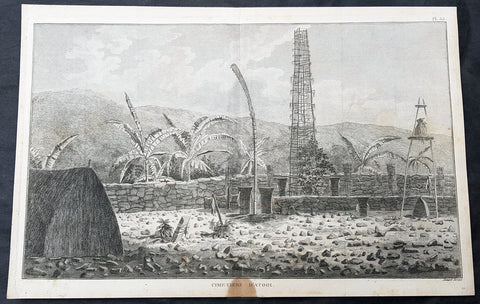
1785 Capt Cook Antique Print Interior of a Heiau, Island of Kauai Hawaii in 1778
- Title : Cimetiere D Atooi (Cemetery in Atooi)
- Size: 15 1/2in x 10in (390mm x 255mm)
- Ref #: 21441
- Date : 1785
- Condition: (A+) Fine Condition
Description:
This fine original copper-plate engraved antique print of the inside of a Hawaiian Heiau - temple - on the Island of Kauai (Atooi) Hawaii, visited by Captain Cook in 1778, during his 3rd & last Voyage of Discovery, was engraved by Robert Benard - after John Webber - and was published in the 1785 French edition of Capt. James Cook & Capt. James King publication A Voyage to the Pacific Ocean. Undertaken, by the Command of his Majesty, for making Discoveries in the Northern Hemisphere. To determine The Position and Extent of the West Side of North America; its Distance from Asia; and the Practicability of a Northern Passage to Europe. Performed under the direction of Captains Cook, Clerke, and Gore, In His Majestys Ships the Resolution and Discovery. In the Years 1776, 1777, 1778, 1779, and 1780. In Three Volumes. Vol. I and II written by James Cook, F.R.S. Vol. III by Captain James King, LL.D. and F.R.S. Paris, 1785.
Captain Cook arrived at Atooi (Kauai) on 19th January 1778 and stayed until 23rd January 1778.
On the 21st January, Cook accompanied by John Webber, proceeded inland from their beach side anchorage to Waimea, on the south coast of Kauai. Their intention was to examine elevated objects visible from the ship. It proved to be a morai, or temple similar to ones they had seen in Tahiti and other South Pacific islands. This structure was nearly 20-feet high and covered in a thin, light-grey cloth, which likely had ceremonial significance. The temple rested on a platform and consisted of thousands of rough-edged lava rock piled in a tight, mortarless fashion. In the center is the spindly-legged oracle tower, where the priest (kahuna) might seek counsel or pray. Carved figures with tapa and leaf offerings are seen outside thatched huts topped with pili, the tall grass that grew throughout the lowlands. In his journal, Cook took particular note of several stone objects he had observed:
...........about the middle of the Morai, there were three of these places in line. We were told three chiefs had been buried there, and before them was another that was oblong. This they called Tanga (taboo or kapu in Hawaiian) and gave us clearly to understand that three human sacrifices had been buried there, that is, one at the burial of each chief. Cooks Journals - January 21, 1778
General Definitions:
Paper thickness and quality: - Heavy and stable
Paper color : - off white
Age of map color: -
Colors used: -
General color appearance: -
Paper size: - 15 1/2in x 10in (390mm x 255mm)
Plate size: - 14 1/2in x 9 1/2in (370mm x 245mm)
Margins: - Min 1/2in (12mm)
Imperfections:
Margins: - Light soiling
Plate area: - None
Verso: - Light soiling
Background:
Kauai is geologically the oldest of the main Hawaiian Islands.
In 1778, Captain James Cook arrived at Waimea Bay, the first European known to have reached the Hawaiian islands. He named the archipelago after his patron the 6th Earl of Sandwich, George Montagu
Hawaii is the 50th and most recent state to have joined the United States of America, having received statehood on August 21, 1959. Hawaii is the only U.S. state located in Oceania and the only one composed entirely of islands. It is the northernmost island group in Polynesia, occupying most of an archipelago in the central Pacific Ocean. Hawaii is the only U.S. state located outside North America.
It is possible that Spanish explorers arrived in the Hawaiian Islands in the 16th century—200 years before Captain James Cook\\\'s first documented visit in 1778. Ruy López de Villalobos commanded a fleet of six ships that left Acapulco in 1542 bound for the Philippines with a Spanish sailor named Juan Gaetano aboard as pilot. Depending on the interpretation, Gaetanos reports describe an encounter with either Hawaii or the Marshall Islands. If de Villalobos crew spotted Hawaii, Gaetano would be considered the first European to see the islands. Some scholars have dismissed these claims due to a lack of credibility.
Spanish archives contain a chart that depicts islands at the same latitude as Hawaii but with a longitude ten degrees east of the islands. In this manuscript, the island of Maui is named La Desgraciada (The Unfortunate Island), and what appears to be Hawaii Island is named La Mesa (The Table). Islands resembling Kahoolawe, Lanai, and Molokai are named Los Monjes (The Monks). For two-and-a-half centuries, Spanish galleons crossed the Pacific from Mexico along a route that passed south of Hawaii on their way to Manila. The exact route was kept secret to protect the Spanish trade monopoly against competing powers.
The 1778 arrival of British explorer James Cook was the first documented contact by a European explorer with Hawaii. Cook named the archipelago as the Sandwich Islands in honor of his sponsor John Montagu, 4th Earl of Sandwich. Cook published the islands location and rendered the native name as Owyhee. This spelling lives on in Owyhee County, Idaho. It was named after three native Hawaiian members of a trapping party who went missing in that area. The Owyhee Mountains were also named for them
Cook visited the Hawaiian Islands twice. As he prepared for departure after his second visit in 1779, a quarrel ensued as Cook took temple idols and fencing as firewood and a minor chief and his men took a ship\\\'s boat. Cook abducted the King of Hawaii Island, Kalani ōpu u, and held him for ransom aboard his ship in order to gain return of Cook\\\'s boat. This tactic had worked in Tahiti and other islands. Instead, Kalani ōpu u s supporters fought back, killing Cook and four marines as Cooks party retreated along the beach to their ship. They departed without the ships boat.
Captain James King FRS 1750 – 1784 was an officer of the Royal Navy. He served under James Cook on his last voyage around the world, specialising in taking important astronomical readings using a sextant. After Cook died he helped lead the ships on the remainder of their course, also completing Cooks account of the voyage. He continued his career in the Navy, reaching the rank of post-captain, commanding several ships and serving in the American War of Independence.
King joined HMS Resolution as second lieutenant, sharing the duties of astronomer with Cook, taking astronomical observations on board by sextant and with Larcum Kendals timekeeper K1, to establish the Resolutions position at sea and on shore by sextant or by astronomical quadrant to establish the geographical position of salient points during the course of Cooks surveys. Thus Kings geographical positions were an important contribution to the accuracy of the various surveys carried out during the voyage and his use of the early chronometers helped prove their use at sea for calculation of Longitude. .
Following the death of Cook, King remained in the Resolution but on the death of Charles Clerke, Cooks successor, King was appointed to command HMS Discovery, the Resolutions consort, remaining in her for the rest of the voyage. After his return to England King was very much involved in the publication of the official account of Cooks third voyage, writing the third volume at Woodstock, near Oxford, where his brother Thomas was rector of St Mary Magdalene. But shortly after his return King was promoted Post-captain and appointed commander of HMS Crocodile in the English Channel.
John Webber RA 1751 – 1793 was an English artist who accompanied Captain Cook on his third Pacific expedition. He is best known for his images of Australasia, Hawaii and Alaska.
Webber was born in London, educated in Bern and studied painting at Paris.His father was Abraham Wäber, a Swiss sculptor who had moved to London, and changed his name to Webber before marrying a Mrs Mary Quant in 1744.
Webber served as official artist on James Cooks third voyage of discovery around the Pacific (1776–80) aboard HMS Resolution. At Adventure Bay in January 1777 he did drawings of A Man of Van Diemens Land and A Woman of Van Diemens Land. He also did many drawings of scenes in New Zealand and the South Sea islands. On this voyage, during which Cook lost his life in a fight in Hawaii, Webber became the first European artist to make contact with Hawaii, then called the Sandwich Islands. He made numerous watercolor landscapes of the islands of Kauai and Hawaii, and also portrayed many of the Hawaiian people.
In April 1778, Captain Cooks ships Resolution and Discovery anchored at Ship Cove, now known as Nootka Sound, Vancouver Island, Canada to refit. The crew took observations and recorded encounters with the local people. Webber made watercolour landscapes including Resolution and Discovery in Ship Cove, 1778. His drawings and paintings were engraved for British Admiraltys account of the expedition, which was published in 1784.
Back in England in 1780 Webber exhibited around 50 works at Royal Academy exhibitions between 1784 and 1792, and was elected an associate of the Royal Academy in 1785 and R.A. in 1791. Most of his work were landscapes. Sometimes figures were included as in A Party from H.M.S. Resolution shooting sea horses, which was shown at the academy in 1784, and his The Death of Captain Cook became well known through an engraving of it. Another version of this picture is in the William Dixson gallery at Sydney
Robert Bénard 1734 – 1777 was an 18th-century French engraver.
Specialized in the technique of engraving, Robert Ménard is mainly famous for having supplied a significant amount of plates (at least 1,800) to the Encyclopédie by Diderot & d Alembert from 1751.
Later, publisher Charles-Joseph Panckoucke reused many of his productions to illustrate the works of his catalog.
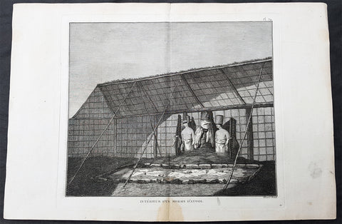
1785 Capt Cook Antique Print Statues in a Heiau, Island of Kauai Hawaii in 1778
- Title : Interieur D Un Morais D Atooi (Interior of a Morais in Atooi)
- Size: 16in x 10in (405mm x 260mm)
- Ref #: 21478
- Date : 1785
- Condition: (A+) Fine Condition
Description:
This fine original copper-plate engraved antique print of statues inside of a Hawaiian Heiau - temple - on the Island of Kauai (Atooi) Hawaii, visited by Captain Cook in 1778, during his 3rd & last Voyage of Discovery, was engraved by Robert Benard - after John Webber - and was published in the 1785 French edition of Capt. James Cook & Capt. James King publication A Voyage to the Pacific Ocean. Undertaken, by the Command of his Majesty, for making Discoveries in the Northern Hemisphere. To determine The Position and Extent of the West Side of North America; its Distance from Asia; and the Practicability of a Northern Passage to Europe. Performed under the direction of Captains Cook, Clerke, and Gore, In His Majestys Ships the Resolution and Discovery. In the Years 1776, 1777, 1778, 1779, and 1780. In Three Volumes. Vol. I and II written by James Cook, F.R.S. Vol. III by Captain James King, LL.D. and F.R.S. Paris, 1785.
Captain Cook arrived at Atooi (Kauai) on 19th January 1778 and stayed until 23rd January 1778.
On the 21st January, Cook accompanied by John Webber, proceeded inland from their beach side anchorage to Waimea, on the south coast of Kauai. Their intention was to examine elevated objects visible from the ship. It proved to be a morai, or temple similar to ones they had seen in Tahiti and other South Pacific islands. This structure was nearly 20-feet high and covered in a thin, light-grey cloth, which likely had ceremonial significance. The temple rested on a platform and consisted of thousands of rough-edged lava rock piled in a tight, mortarless fashion. In the center is the spindly-legged oracle tower, where the priest (kahuna) might seek counsel or pray. Carved figures with tapa and leaf offerings are seen outside thatched huts topped with pili, the tall grass that grew throughout the lowlands. In his journal, Cook took particular note of several stone objects he had observed:
...........about the middle of the Morai, there were three of these places in line. We were told three chiefs had been buried there, and before them was another that was oblong. This they called Tanga (taboo or kapu in Hawaiian) and gave us clearly to understand that three human sacrifices had been buried there, that is, one at the burial of each chief. Cooks Journals - January 21, 1778
General Definitions:
Paper thickness and quality: - Heavy and stable
Paper color : - off white
Age of map color: -
Colors used: -
General color appearance: -
Paper size: - 16in x 10in (405mm x 260mm)
Plate size: - 11in x 9 1/2in (280mm x 245mm)
Margins: - Min 1/2in (12mm)
Imperfections:
Margins: - Light soiling
Plate area: - None
Verso: - Light soiling
Background:
Kauai is geologically the oldest of the main Hawaiian Islands.
In 1778, Captain James Cook arrived at Waimea Bay, the first European known to have reached the Hawaiian islands. He named the archipelago after his patron the 6th Earl of Sandwich, George Montagu
Hawaii is the 50th and most recent state to have joined the United States of America, having received statehood on August 21, 1959. Hawaii is the only U.S. state located in Oceania and the only one composed entirely of islands. It is the northernmost island group in Polynesia, occupying most of an archipelago in the central Pacific Ocean. Hawaii is the only U.S. state located outside North America.
It is possible that Spanish explorers arrived in the Hawaiian Islands in the 16th century—200 years before Captain James Cook\\\'s first documented visit in 1778. Ruy López de Villalobos commanded a fleet of six ships that left Acapulco in 1542 bound for the Philippines with a Spanish sailor named Juan Gaetano aboard as pilot. Depending on the interpretation, Gaetanos reports describe an encounter with either Hawaii or the Marshall Islands. If de Villalobos crew spotted Hawaii, Gaetano would be considered the first European to see the islands. Some scholars have dismissed these claims due to a lack of credibility.
Spanish archives contain a chart that depicts islands at the same latitude as Hawaii but with a longitude ten degrees east of the islands. In this manuscript, the island of Maui is named La Desgraciada (The Unfortunate Island), and what appears to be Hawaii Island is named La Mesa (The Table). Islands resembling Kahoolawe, Lanai, and Molokai are named Los Monjes (The Monks). For two-and-a-half centuries, Spanish galleons crossed the Pacific from Mexico along a route that passed south of Hawaii on their way to Manila. The exact route was kept secret to protect the Spanish trade monopoly against competing powers.
The 1778 arrival of British explorer James Cook was the first documented contact by a European explorer with Hawaii. Cook named the archipelago as the Sandwich Islands in honor of his sponsor John Montagu, 4th Earl of Sandwich. Cook published the islands location and rendered the native name as Owyhee. This spelling lives on in Owyhee County, Idaho. It was named after three native Hawaiian members of a trapping party who went missing in that area. The Owyhee Mountains were also named for them
Cook visited the Hawaiian Islands twice. As he prepared for departure after his second visit in 1779, a quarrel ensued as Cook took temple idols and fencing as firewood and a minor chief and his men took a ship\\\'s boat. Cook abducted the King of Hawaii Island, Kalani ōpu u, and held him for ransom aboard his ship in order to gain return of Cook\\\'s boat. This tactic had worked in Tahiti and other islands. Instead, Kalani ōpu u s supporters fought back, killing Cook and four marines as Cooks party retreated along the beach to their ship. They departed without the ships boat.
Captain James King FRS 1750 – 1784 was an officer of the Royal Navy. He served under James Cook on his last voyage around the world, specialising in taking important astronomical readings using a sextant. After Cook died he helped lead the ships on the remainder of their course, also completing Cooks account of the voyage. He continued his career in the Navy, reaching the rank of post-captain, commanding several ships and serving in the American War of Independence.
King joined HMS Resolution as second lieutenant, sharing the duties of astronomer with Cook, taking astronomical observations on board by sextant and with Larcum Kendals timekeeper K1, to establish the Resolutions position at sea and on shore by sextant or by astronomical quadrant to establish the geographical position of salient points during the course of Cooks surveys. Thus Kings geographical positions were an important contribution to the accuracy of the various surveys carried out during the voyage and his use of the early chronometers helped prove their use at sea for calculation of Longitude. .
Following the death of Cook, King remained in the Resolution but on the death of Charles Clerke, Cooks successor, King was appointed to command HMS Discovery, the Resolutions consort, remaining in her for the rest of the voyage. After his return to England King was very much involved in the publication of the official account of Cooks third voyage, writing the third volume at Woodstock, near Oxford, where his brother Thomas was rector of St Mary Magdalene. But shortly after his return King was promoted Post-captain and appointed commander of HMS Crocodile in the English Channel.
John Webber RA 1751 – 1793 was an English artist who accompanied Captain Cook on his third Pacific expedition. He is best known for his images of Australasia, Hawaii and Alaska.
Webber was born in London, educated in Bern and studied painting at Paris.His father was Abraham Wäber, a Swiss sculptor who had moved to London, and changed his name to Webber before marrying a Mrs Mary Quant in 1744.
Webber served as official artist on James Cooks third voyage of discovery around the Pacific (1776–80) aboard HMS Resolution. At Adventure Bay in January 1777 he did drawings of A Man of Van Diemens Land and A Woman of Van Diemens Land. He also did many drawings of scenes in New Zealand and the South Sea islands. On this voyage, during which Cook lost his life in a fight in Hawaii, Webber became the first European artist to make contact with Hawaii, then called the Sandwich Islands. He made numerous watercolor landscapes of the islands of Kauai and Hawaii, and also portrayed many of the Hawaiian people.
In April 1778, Captain Cooks ships Resolution and Discovery anchored at Ship Cove, now known as Nootka Sound, Vancouver Island, Canada to refit. The crew took observations and recorded encounters with the local people. Webber made watercolour landscapes including Resolution and Discovery in Ship Cove, 1778. His drawings and paintings were engraved for British Admiraltys account of the expedition, which was published in 1784.
Back in England in 1780 Webber exhibited around 50 works at Royal Academy exhibitions between 1784 and 1792, and was elected an associate of the Royal Academy in 1785 and R.A. in 1791. Most of his work were landscapes. Sometimes figures were included as in A Party from H.M.S. Resolution shooting sea horses, which was shown at the academy in 1784, and his The Death of Captain Cook became well known through an engraving of it. Another version of this picture is in the William Dixson gallery at Sydney
Robert Bénard 1734 – 1777 was an 18th-century French engraver.
Specialized in the technique of engraving, Robert Ménard is mainly famous for having supplied a significant amount of plates (at least 1,800) to the Encyclopédie by Diderot & d Alembert from 1751.
Later, publisher Charles-Joseph Panckoucke reused many of his productions to illustrate the works of his catalog.
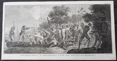
1778 Capt Cook Antique Print Crew & Marines Landing Erromango Isle Vanuatu, 1774
- Title : Debarquement A Erramanga, Lune Des Nouvelles Hebrides (Landing at Erramanga, of the new Hebrides)
- Size: 19in x 10in (485mm x 255mm)
- Ref #: 31828
- Date : 1778
- Condition: (A) Very Good Condition
Description:
This large original copper-plate engraved antique print of crew and Marines of HMS Resolution landing on the Island of Erromango - with Resolution in the background - an island in the Vanuatu (New Hebrides) group of Islands, visited by Captain James Cook in 1774, during his 2nd Voyage of Discovery to the South Seas, was engraved by Robert Benard - after William Hodges - and was published in the 1778 French edition of Capt. James Cooks 2nd Voyage of Discovery to the South Seas A voyage towards the South Pole, and round the World. Performed in His Majestys ships the Resolution and Adventure, in the years 1772, 1773, 1774, and 1775..... Paris : Hotel de Thou ......1778.
(August 1774)............on 2nd they looked for an anchorage down the west coast, the next day down the east coast, finally anchoring on 4th. Cook went with two boats to view the coast and to look for a proper landing place, wood and Water. At \"a Sandy Beach, where I could step out of the boat without weting a foot [he] landed in the face of a great Multitude with nothing but a green branch in my hand... I was received very courteously... in short I was charmed with thier behavour\". Soon, however, he had to give orders to fire as they now began to Shoot their Arrows and throw darts and Stones at us, the first discharge threw them into confusion but a nother discharge was hardly sufficient to drive them of the beach and after all they continued to throw Stones from behind the trees and bushes.............
General Definitions:
Paper thickness and quality: - Heavy and stable
Paper color : - off white
Age of map color: -
Colors used: -
General color appearance: -
Paper size: - 19in x 10in (485mm x 255mm)
Plate size: - 19in x 9 1/2in (485mm x 245mm)
Margins: - Min 1/2in (12mm)
Imperfections:
Margins: - None
Plate area: - Folds as issued, creasing along folds
Verso: - None
Background:
Erromango is the fourth largest island in the Vanuatu archipelago. With a land area of 891.9 square kilometres it is the largest island in Tafea Province, the southernmost of Vanuatu\'s six administrative regions.
James Cook was the first European to land on Erromango, landing near present-day Potnarvin in the north-east on 4 August 1774. Cook and his landing party were set upon by a group of local men, and in the scuffle that followed, several of Cook\'s men were injured and a number of Erromangans killed. Following this incident, Cook gave the name Traitor\'s head to the peninsula adjacent to Potnarvin
Vanuatu is a Pacific island nation located in the South Pacific Ocean. The archipelago, which is of volcanic origin, is 1,750 kilometres east of northern Australia, 540 kilometres northeast of New Caledonia, east of New Guinea, southeast of the Solomon Islands, and west of Fiji.
The Vanuatu group of islands first had contact with Europeans in 1606, when the Portuguese explorer Pedro Fernandes de Queirós, sailing for the Spanish Crown, arrived on the largest island and called the group of islands La Austrialia del Espiritu Santo or The Southern Land of the Holy Spirit, believing he had arrived in Terra Australis or Australia. The Spanish established a short-lived settlement at Big Bay on the north side of the island. The name Espiritu Santo remains to this day.
Europeans did not return until 1768, when Louis Antoine de Bougainville rediscovered the islands on 22 May, naming them the Great Cyclades. In 1774, Captain Cook named the islands the New Hebrides, a name that would last until independence in 1980.
William Hodges RA 1744 – 1797 was an English painter. He was a member of James Cooks second voyage to the Pacific Ocean, and is best known for the sketches and paintings of locations he visited on that voyage, including Table Bay, Tahiti, Easter Island, and the Antarctic.
Between 1772 and 1775 Hodges accompanied James Cook to the Pacific as the expeditions artist. Many of his sketches and wash paintings were adapted as engravings in the original published edition of Cooks journals from the voyage.
Most of the large-scale landscape oil paintings from his Pacific travels for which Hodges is best known were finished after his return to London; he received a salary from the Admiralty for the purposes of completing them. These paintings depicted a stronger light and shadow than had been usual in European landscape tradition. Contemporary art critics complained that his use of light and colour contrasts gave his paintings a rough and unfinished appearance.
Hodges also produced many valuable portrait sketches of Pacific islanders and scenes from the voyage involving members of the expedition..
Robert Bénard 1734 – 1777 was an 18th-century French engraver.
Specialized in the technique of engraving, Robert Ménard is mainly famous for having supplied a significant amount of plates (at least 1,800) to the Encyclopédie by Diderot & d\'Alembert from 1751.
Later, publisher Charles-Joseph Panckoucke reused many of his productions to illustrate the works of his catalog.
1785 Cook Antique Print HMS Resolution & Discovery, Prince William Sound, Alaska
- Title : Vue de Lanse Fermee de l entree Du Prince Guillaume (Entrance & view of the Prince William)
- Size: 14 1/2in x 10in (370mm x 255mm)
- Ref #: 31839
- Date : 1785
- Condition: (A) Very Good Condition
Description:
This fine original copper-plate engraved antique print of Captain Cooks ships HMS Resolution and Discovery anchored in Snug Corner Cove, Prince William Sound, Alaska, visited by Captain Cook in 1778, during his 3rd & last Voyage of Discovery, was engraved by Robert Benard - after John Webber - and was published in the 1785 French edition of Capt. James Cook & Capt. James King publication A Voyage to the Pacific Ocean. Undertaken, by the Command of his Majesty, for making Discoveries in the Northern Hemisphere. To determine The Position and Extent of the West Side of North America; its Distance from Asia; and the Practicability of a Northern Passage to Europe. Performed under the direction of Captains Cook, Clerke, and Gore, In His Majestys Ships the Resolution and Discovery. In the Years 1776, 1777, 1778, 1779, and 1780. In Three Volumes. Vol. I and II written by James Cook, F.R.S. Vol. III by Captain James King, LL.D. and F.R.S. Paris, 1785.
May 1778.........On the 12th at nine in the morning, wrote Ledyard, we entered an inlet… at six in the evening perceiving bad weather approaching… both ships anchored… The pinnace of the Resolution with the first lieutenant, some other gentlemen and myself went to the opposite shore to shoot some wild fowl. The first lieutenant was John Gore. The inlet was named Sandwich Sound by Cook, after the Earl of Sandwich, First Lord of the Admiralty, but in the published version of his journal the name appeared as Prince Williams Sound, after George IIIs third son, Duke of Clarence, later William IV. The ships had anchored off Cape Hinchinbrook, named after the country seat of the Earl of Sandwich.
Some local inhabitants appeared and came aboard the ships. Clerke gave them a Glass Bowl, with which they seem\'d much delighted, and toss\'d me, in spight of all my motions to the contrary, one of their Frocks, which was made of Water fowl Skins, and exceedingly well calculated, to keep out both Wet & Cold; then, both Boats put off and made for the Shore, paddling & singing with all the Jollity imaginable. We either found these good folks on of their Jubilee Days, or they are a very happy Race.
They sailed on until Cook found a fine bay or rather harbour which he later called a very snug place and named Snug Corner Bay. Samwell on 14th wrote we secured the Ship with the small Anchor; in carrying this out in the Launch one of the Sailors was so unfortunate as to get his Leg entangled in the Buoy rope which carried him down with the Anchor, however he disengaged himself when he got to the bottom & came up again & saved his Life tho\' he had his Leg broke in a very dangerous Manner.
We heeled the ship to port wrote Gilbert, to examine the leak on the starboard buttock… it being close below the wale and occasioned by some of the seems being very open and the oakum quite rotten and great part of it got out. In two days we repaired this defect being obliged to put two and half inch rope along the seams which were too wide for caulking.
On 18th King noted two boats, one with Mr Gore & the other with the Master, were sent away, the first to explore the Inlet to the Noward: the other to the N end of the Island near us to make observations on the tides. William Bligh was master on the Resolution. They returned by Dusk, Mr Gore had proceeded up the Inlet & perceivd that it took a direction to the NE, & he thought that it bid fair for opening a communication to some other Sea; but the mate that was with him form\'d a very contrary opinion… the Captn judg\'d it the Wisest way to lose no more time, being certain that if we were amongst Islands, we shoud soon come to more Passages. Henry Roberts was the masters mate referred to here. Cook had sent him and others to sketch out the parts they examined
General Definitions:
Paper thickness and quality: - Heavy and stable
Paper color : - off white
Age of map color: -
Colors used: -
General color appearance: -
Paper size: - 14 1/2in x 10in (370mm x 255mm)
Plate size: - 14in x 10in (365mm x 255mm)
Margins: - Min 1/2in (12mm)
Imperfections:
Margins: - L&R margins cropped close to borders
Plate area: - None
Verso: - Light soiling
Background:
Prince William Sound is located on the south coast of the U.S. state of Alaska. It is located on the east side of the Kenai Peninsula, its largest port is Valdez, at the southern terminus of the Trans-Alaska Pipeline System. Other settlements on the sound contain numerous small islands, including Cordova and Whittier plus the Alaska native villages of Chenega and Tatitlek.
James Cook entered Prince William Sound in 1778 and named it Sandwich Sound, after his patron the Earl of Sandwich. The name was changed to honour King George III third son, Prince William Henry, then aged 13 and serving as a midshipman in the Royal Navy.
Captain James King FRS 1750 – 1784 was an officer of the Royal Navy. He served under James Cook on his last voyage around the world, specialising in taking important astronomical readings using a sextant. After Cook died he helped lead the ships on the remainder of their course, also completing Cooks account of the voyage. He continued his career in the Navy, reaching the rank of post-captain, commanding several ships and serving in the American War of Independence.
King joined HMS Resolution as second lieutenant, sharing the duties of astronomer with Cook, taking astronomical observations on board by sextant and with Larcum Kendals timekeeper K1, to establish the Resolutions position at sea and on shore by sextant or by astronomical quadrant to establish the geographical position of salient points during the course of Cooks surveys. Thus Kings geographical positions were an important contribution to the accuracy of the various surveys carried out during the voyage and his use of the early chronometers helped prove their use at sea for calculation of Longitude. .
Following the death of Cook, King remained in the Resolution but on the death of Charles Clerke, Cooks successor, King was appointed to command HMS Discovery, the Resolutions consort, remaining in her for the rest of the voyage. After his return to England King was very much involved in the publication of the official account of Cooks third voyage, writing the third volume at Woodstock, near Oxford, where his brother Thomas was rector of St Mary Magdalene. But shortly after his return King was promoted Post-captain and appointed commander of HMS Crocodile in the English Channel.
John Webber RA 1751 – 1793 was an English artist who accompanied Captain Cook on his third Pacific expedition. He is best known for his images of Australasia, Hawaii and Alaska.
Webber was born in London, educated in Bern and studied painting at Paris.His father was Abraham Wäber, a Swiss sculptor who had moved to London, and changed his name to Webber before marrying a Mrs Mary Quant in 1744.
Webber served as official artist on James Cooks third voyage of discovery around the Pacific (1776–80) aboard HMS Resolution. At Adventure Bay in January 1777 he did drawings of A Man of Van Diemens Land and A Woman of Van Diemens Land. He also did many drawings of scenes in New Zealand and the South Sea islands. On this voyage, during which Cook lost his life in a fight in Hawaii, Webber became the first European artist to make contact with Hawaii, then called the Sandwich Islands. He made numerous watercolor landscapes of the islands of Kauai and Hawaii, and also portrayed many of the Hawaiian people.
In April 1778, Captain Cooks ships Resolution and Discovery anchored at Ship Cove, now known as Nootka Sound, Vancouver Island, Canada to refit. The crew took observations and recorded encounters with the local people. Webber made watercolour landscapes including Resolution and Discovery in Ship Cove, 1778. His drawings and paintings were engraved for British Admiraltys account of the expedition, which was published in 1784.
Back in England in 1780 Webber exhibited around 50 works at Royal Academy exhibitions between 1784 and 1792, and was elected an associate of the Royal Academy in 1785 and R.A. in 1791. Most of his work were landscapes. Sometimes figures were included as in A Party from H.M.S. Resolution shooting sea horses, which was shown at the academy in 1784, and his The Death of Captain Cook became well known through an engraving of it. Another version of this picture is in the William Dixson gallery at Sydney
Robert Bénard 1734 – 1777 was an 18th-century French engraver.
Specialized in the technique of engraving, Robert Ménard is mainly famous for having supplied a significant amount of plates (at least 1,800) to the Encyclopédie by Diderot & d Alembert from 1751.
Later, publisher Charles-Joseph Panckoucke reused many of his productions to illustrate the works of his catalog.
1774 Hawkesworth Antique Print Capt Wallis attacked in Matavia Bay, Tahiti, 1767
- Title : Le Capitaine Wallis est attaque dans L Dauphin par les Otahitiens (Captain Wallis attacked in The Dolphin by the Tahitians)
- Size: 14in x 10in (365mm x 255mm)
- Ref #: 25928
- Date : 1774
- Condition: (A+) Fine Condition
Description:
This fine original copper-plate engraved antique print of Captain Samuel Wallis in his ship the HMS Dolphin being attacked by the Tahitians in Matavai Bay - with one tree hill to the right - in 1767 was engraved by Robert Benard and was published in the 1774 French edition of John Hawkesworths An Account of the Voyages Undertaken by the Order of His Present Majesty for Making Discoveries in the Southern Hemisphere and Successively Performed by Commodore Byron, Captain Wallis, Captain Carteret, and Captain Cook, in the Dolphin, the Swallow, and the Endeavor, Drawn Up from the Journals Which Were Kept by the Several Commanders, and from the Papers of Joseph Banks, Esq. Paris 1774
From the log of Samuel Wallis, Captain of The Dolphin 1767.......
At two in the morning, it being very clear, we made sail again; at day-break we saw the land, at about five leagues distance, and steered directly for it; but at eight o’clock, when we were close under it, the fog obliged us again to lie to, and when it cleared away, we were much surprised to find ourselves surrounded by some hundreds of canoes…. When they came within pistol shot of the ship, they lay by, gazing at us with great astonishment, and by turns conferring with each other. In the mean time we showed them trinkets of various kinds, and invited them on board. Soon after, they drew together, and held a kind of council, to determine what should be done: then they all paddled around the ship, making signs of friendship, and one of them holding up a branch of the plantain tree, made a speech that lasted near a quarter of an hour, and then threw it into the sea. Soon after, as we continued to make signs of invitation, a fine, stout, lively young man ventured on board: he came up by the mizzen chains, and jumped out of the shrouds on top of the awning. We made signs to him to come down upon the quarter-deck, and handed up some trinkets to him: he looked pleased, but would accept of nothing till some of the Indians came alongside, and after much talk, threw a few branches of plantain tree on board the ship. He then accepted our presents, and several others very soon came on board.
As we had no anchorage here, we stood along the shore, sending the boats at the same time to sound at a less distance…. About three o’clock in the afternoon, we brought to, abreast of a large bay, where there was an appearance of anchorage. The boats were immediately sent to sound it, and while they were thus employed, I observed a great number of canoes gather round them. I suspected that the Indians had a design to attack them, and as I was very desirous to prevent mischief, I made the signal for the boats to come aboard, and at the same time, to intimidate the Indians, I fired a nine-pounder over their heads. As soon as the cutter began to stand towards the ship, the Indians in their canoes, though they had been startled by the thunder of our nine-pounder, endeavoured to cut her off. The boat, however, sailing faster than the canoes could paddle, soon got clear of those that were about her; but some others, that were full of men, waylaid her in her course, and threw several stones into her, which wounded some of the people. Upon this, the officer on board fired a musquet, loaded with buck-shot, at the man who threw the first stone, and wounded him in the shoulder. The rest of the people in the canoes, as soon as they perceived their companion wounded, leapt in to the sea, and the other canoes paddled away, in great terror and confusion.
General Definitions:
Paper thickness and quality: - Heavy and stable
Paper color : - off white
Age of map color: -
Colors used: -
General color appearance: -
Paper size: - 14in x 10in (365mm x 255mm)
Plate size: - 14in x 10in (365mm x 255mm)
Margins: - Min 1/2in (12mm)
Imperfections:
Margins: - None
Plate area: - Folds as issued
Verso: - None
Background:
Samuel Wallis 1728 – 1795
was a British naval officer and explorer of the Pacific Ocean.
Wallis was born near Camelford, Cornwall. He served under John Byron, and in 1766 was promoted to captain and was given the command of HMS Dolphin (1751) as part of an expedition led by Philip Carteret in the Swallow with an assignment to circumnavigate the globe. The two ships were parted by a storm shortly after sailing through the Strait of Magellan, Wallis continuing to Tahiti, which he named King George the Thirds Island in honour of the King (June 1767). Wallis himself was ill and remained in his cabin: lieutenant Tobias Furneaux was the first to set foot, hoisting a pennant and turning a turf, taking possession in the name of His Majesty. Dolphin stayed in Matavai Bay in Tahiti for over a month. Wallis went on to name or rename five more islands in the Society Islands and six atolls in the Tuamotu Islands, as well as confirming the locations of Rongerik and Rongelap in the Marshall Islands. He renamed the Polynesian island of Uvea as Wallis after himself, before reaching Tinian in the Mariana Islands. He continued to Batavia, where many of the crew died from dysentery, then via the Cape of Good Hope to England, arriving in May 1768. He was able to pass on useful information to James Cook who was due to depart shortly for the Pacific, and some of the crew from the Dolphin sailed with Cook. In 1780 Wallis was appointed Commissioner of the Admiralty.
Tahiti previously also known as Otaheite is the largest island in the Windward group of French Polynesia. The island is located in the archipelago of the Society Islands in the central Southern Pacific Ocean.
The first European to have visited Tahiti according to existing records was lieutenant Samuel Wallis, who was circumnavigating the globe in HMS Dolphin, sighting the island on 18 June 1767, and eventually harboring in Matavai Bay. This bay was situated on the territory of the chiefdom of Pare-Arue, governed by Tu (Tu-nui-e-a a-i-te-Atua) and his regent Tutaha, and the chiefdom of Ha apape, governed by Amo and his wife Oberea (Purea). Wallis named the island King Georges Island. The first contacts were difficult, since on the 24 and 26 June 1767, Tahitian warriors in canoes showed aggression towards the British, hurling stones from their slings. In retaliation, the British sailors opened fire on the warriors in the canoes and on the hills. In reaction to this powerful counter-attack, the Tahitians laid down peace offerings for the British. Following this episode, Samuel Wallis was able to establish cordial relations with the female chieftain “Oberea “ (Purea) and remained on the island until 27 July 1767.
In July 1768, Captain James Cook was commissioned by the Royal Society and on orders from the Lords Commissioners of the Admiralty to observe the transit of Venus across the sun, a phenomenon that would be visible from Tahiti on 3 June 1769. He arrived in Tahitis Matavai Bay, commanding the HMS Endeavour on 12 April 1769. On 14 April, Cook met with Tutaha and Tepau. On 15 April, Cook picked the site for a fortified camp at Point Venus along with Banks, Parkinson, Daniel Solander, to protect Charles Greens observatory. The length of stay enabled them to undertake for the first time real ethnographic and scientific observations of the island. Assisted by the botanist Joseph Banks, and by the artist Sydney Parkinson, Cook gathered valuable information on the fauna and flora, as well as the native society, language and customs, including the proper name of the island, Otaheite. On 28 April, Cook met Purea and Tupaia, and Tupaia befriended Banks following the transit. On 21 June, Amo visited Cook, and then on 25 June, Pohuetea visited, signifying another chief seeking to ally himself with the British.
Cook and Banks circumnavigated the island from 26 June to 1 July. On the exploration, they met Ahio, chief of Ha apaiano o or Papenoo, Rita, chief of Hitia a, Pahairro, chief of Pueu, Vehiatua, chief of Tautra, Matahiapo, chief of Teahupo o, Tutea, chief of Vaira o, and Moe, chief of Afa Ahiti. In Papara, guided by Tupaia, they investigated the ruins of Mahaiatea marae, an impressive structure containing a stone pyramid or ahu, measuring 44 feet high, 267 feet long and 87 feet wide. Cook and the Endeavour departed Tahiti on 13 July 1769, taking Raiatean navigator Tupaia along for his geographic knowledge of the islands.
Cook returned to Tahiti between 15 August and 1 September 1773, greeted by the chiefs Tai and Puhi, besides the youg ari i Vehiatua II and his stepfather Ti itorea. Cook anchored in Vaitepiha Bay before returning to Point Venus where he met Tu, the paramount chief. Cook picked up two passengers from Tahiti during this trip, Porea and Mai, with Hitihiti later replacing Porea when Cook stopped at Raiatea. Cook took Hitihiti to Tahiti on 22 April, during his return leg. Then, Cook departed Tahiti on 14 May 1774.
During his final visit, Cook returned Mai to Tahiti on 12 Aug. 1777, after Mais long visit in England. Cook also brought two Maori from Queen Charlotte Sound, Te Weherua and Koa. Cook first harbored in Vaitepiha Bay, where he visited Vehiatua II s funeral bier and the prefabricated Spanish mission house. Cook also met Vehiatua III, and inscribed on the back of the Spanish cross, Georgius tertius Rex Annis 1767, 69, 73, 74 & 77, as a counterpoint to Christus Vincit Carolus III imperat 1774 on the front. On 23 Aug., Cook sailed for Matavai Bay, where he met Tu, his father Teu, his mother Tetupaia, his brothers Ari ipaea and Vaetua, and his sisters Ari ipaea-vahine, Tetua-te-ahamai, and Auo. Cook also observed a human sacrifice, taata tapu, at the Utu-ai-mahurau marae, and 49 skulls from previous victims.
On 29 Sept. 1777, Cook sailed for Papetoai Bay on Moorea. Cook met Mahine in an act of friendship on 3 Oct., though he was an enemy of Tu. When a goat kid was stolen on 6 Oct., Cook in a rampage, ordered the burning of houses and canoes until it was returned. Cook sailed for Huahine on 11 Oct., Raiatea on 2 Nov., and Borabora on 7 Dec.
On 26 October 1788, HMS Bounty, under the command of Captain William Bligh, landed in Tahiti with the mission of carrying Tahitian breadfruit trees (Tahitian: uru) to the Caribbean. Sir Joseph Banks, the botanist from James Cooks first expedition, had concluded that this plant would be ideal to feed the African slaves working in the Caribbean plantations at very little cost. The crew remained in Tahiti for about five months, the time needed to transplant the seedlings of the trees. Three weeks after leaving Tahiti, on 28 April 1789, the crew mutinied on the initiative of Fletcher Christian. The mutineers seized the ship and set the captain and most of those members of the crew who remained loyal to him adrift in a ships boat. A group of mutineers then went back to settle in Tahiti.
Although various explorers had refused to get involved in tribal conflicts, the mutineers from the Bounty offered their services as mercenaries and furnished arms to the family which became the Pōmare Dynasty. The chief Tū knew how to use their presence in the harbours favoured by sailors to his advantage. As a result of his alliance with the mutineers, he succeeded in considerably increasing his supremacy over the island of Tahiti.
Robert Bénard 1734 – 1777 was an 18th-century French engraver.
Specialized in the technique of engraving, Robert Ménard is mainly famous for having supplied a significant amount of plates (at least 1,800) to the Encyclopédie by Diderot & d\'Alembert from 1751.
Later, publisher Charles-Joseph Panckoucke reused many of his productions to illustrate the works of his catalog.
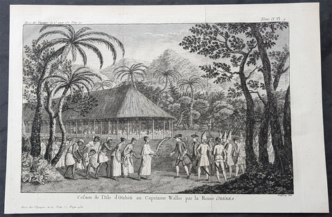
1774 Hawkesworth Antique Print Queen Purea Surrender to Capt Wallis Tahiti, 1767
- Title : Cession de lisle D otahiti au Capitaine Wallis par la Reine Oberea (Surrender of the Island of Taahiti to Capt Wallis by Queen Obera)
- Size: 14in x 10in (365mm x 255mm)
- Ref #: 25925
- Date : 1774
- Condition: (A) Very Good Condition
Description:
This fine original copper-plate engraved antique print of Captain Samuel Wallis - the first European to visit Tahiti in 1767 - accepting surrender from Queen Purea (Oberea) of Tahiti, after the battle in Matavia Bay in 1767, was engraved by Robert Benard and was published in the 1774 French edition of John Hawkesworths An Account of the Voyages Undertaken by the Order of His Present Majesty for Making Discoveries in the Southern Hemisphere and Successively Performed by Commodore Byron, Captain Wallis, Captain Carteret, and Captain Cook, in the Dolphin, the Swallow, and the Endeavor, Drawn Up from the Journals Which Were Kept by the Several Commanders, and from the Papers of Joseph Banks, Esq. Paris 1774
From the log of Samuel Wallis, Captain of The Dolphin 1767.......
At two in the morning, it being very clear, we made sail again; at day-break we saw the land, at about five leagues distance, and steered directly for it; but at eight o’clock, when we were close under it, the fog obliged us again to lie to, and when it cleared away, we were much surprised to find ourselves surrounded by some hundreds of canoes…. When they came within pistol shot of the ship, they lay by, gazing at us with great astonishment, and by turns conferring with each other. In the mean time we showed them trinkets of various kinds, and invited them on board. Soon after, they drew together, and held a kind of council, to determine what should be done: then they all paddled around the ship, making signs of friendship, and one of them holding up a branch of the plantain tree, made a speech that lasted near a quarter of an hour, and then threw it into the sea. Soon after, as we continued to make signs of invitation, a fine, stout, lively young man ventured on board: he came up by the mizzen chains, and jumped out of the shrouds on top of the awning. We made signs to him to come down upon the quarter-deck, and handed up some trinkets to him: he looked pleased, but would accept of nothing till some of the Indians came alongside, and after much talk, threw a few branches of plantain tree on board the ship. He then accepted our presents, and several others very soon came on board.
As we had no anchorage here, we stood along the shore, sending the boats at the same time to sound at a less distance…. About three o’clock in the afternoon, we brought to, abreast of a large bay, where there was an appearance of anchorage. The boats were immediately sent to sound it, and while they were thus employed, I observed a great number of canoes gather round them. I suspected that the Indians had a design to attack them, and as I was very desirous to prevent mischief, I made the signal for the boats to come aboard, and at the same time, to intimidate the Indians, I fired a nine-pounder over their heads. As soon as the cutter began to stand towards the ship, the Indians in their canoes, though they had been startled by the thunder of our nine-pounder, endeavoured to cut her off. The boat, however, sailing faster than the canoes could paddle, soon got clear of those that were about her; but some others, that were full of men, waylaid her in her course, and threw several stones into her, which wounded some of the people. Upon this, the officer on board fired a musquet, loaded with buck-shot, at the man who threw the first stone, and wounded him in the shoulder. The rest of the people in the canoes, as soon as they perceived their companion wounded, leapt in to the sea, and the other canoes paddled away, in great terror and confusion.
General Definitions:
Paper thickness and quality: - Heavy and stable
Paper color : - off white
Age of map color: -
Colors used: -
General color appearance: -
Paper size: - 14in x 10in (365mm x 255mm)
Plate size: - 14in x 10in (365mm x 255mm)
Margins: - Min 1/2in (12mm)
Imperfections:
Margins: - None
Plate area: - Folds as issued
Verso: - None
Background:
Samuel Wallis 1728 – 1795
was a British naval officer and explorer of the Pacific Ocean.
Wallis was born near Camelford, Cornwall. He served under John Byron, and in 1766 was promoted to captain and was given the command of HMS Dolphin (1751) as part of an expedition led by Philip Carteret in the Swallow with an assignment to circumnavigate the globe. The two ships were parted by a storm shortly after sailing through the Strait of Magellan, Wallis continuing to Tahiti, which he named King George the Thirds Island in honour of the King (June 1767). Wallis himself was ill and remained in his cabin: lieutenant Tobias Furneaux was the first to set foot, hoisting a pennant and turning a turf, taking possession in the name of His Majesty. Dolphin stayed in Matavai Bay in Tahiti for over a month. Wallis went on to name or rename five more islands in the Society Islands and six atolls in the Tuamotu Islands, as well as confirming the locations of Rongerik and Rongelap in the Marshall Islands. He renamed the Polynesian island of Uvea as Wallis after himself, before reaching Tinian in the Mariana Islands. He continued to Batavia, where many of the crew died from dysentery, then via the Cape of Good Hope to England, arriving in May 1768. He was able to pass on useful information to James Cook who was due to depart shortly for the Pacific, and some of the crew from the Dolphin sailed with Cook. In 1780 Wallis was appointed Commissioner of the Admiralty.
Tahiti previously also known as Otaheite is the largest island in the Windward group of French Polynesia. The island is located in the archipelago of the Society Islands in the central Southern Pacific Ocean.
The first European to have visited Tahiti according to existing records was lieutenant Samuel Wallis, who was circumnavigating the globe in HMS Dolphin, sighting the island on 18 June 1767, and eventually harboring in Matavai Bay. This bay was situated on the territory of the chiefdom of Pare-Arue, governed by Tu (Tu-nui-e-a a-i-te-Atua) and his regent Tutaha, and the chiefdom of Ha apape, governed by Amo and his wife Oberea (Purea). Wallis named the island King Georges Island. The first contacts were difficult, since on the 24 and 26 June 1767, Tahitian warriors in canoes showed aggression towards the British, hurling stones from their slings. In retaliation, the British sailors opened fire on the warriors in the canoes and on the hills. In reaction to this powerful counter-attack, the Tahitians laid down peace offerings for the British. Following this episode, Samuel Wallis was able to establish cordial relations with the female chieftain “Oberea “ (Purea) and remained on the island until 27 July 1767.
In July 1768, Captain James Cook was commissioned by the Royal Society and on orders from the Lords Commissioners of the Admiralty to observe the transit of Venus across the sun, a phenomenon that would be visible from Tahiti on 3 June 1769. He arrived in Tahitis Matavai Bay, commanding the HMS Endeavour on 12 April 1769. On 14 April, Cook met with Tutaha and Tepau. On 15 April, Cook picked the site for a fortified camp at Point Venus along with Banks, Parkinson, Daniel Solander, to protect Charles Greens observatory. The length of stay enabled them to undertake for the first time real ethnographic and scientific observations of the island. Assisted by the botanist Joseph Banks, and by the artist Sydney Parkinson, Cook gathered valuable information on the fauna and flora, as well as the native society, language and customs, including the proper name of the island, Otaheite. On 28 April, Cook met Purea and Tupaia, and Tupaia befriended Banks following the transit. On 21 June, Amo visited Cook, and then on 25 June, Pohuetea visited, signifying another chief seeking to ally himself with the British.
Cook and Banks circumnavigated the island from 26 June to 1 July. On the exploration, they met Ahio, chief of Ha apaiano o or Papenoo, Rita, chief of Hitia a, Pahairro, chief of Pueu, Vehiatua, chief of Tautra, Matahiapo, chief of Teahupo o, Tutea, chief of Vaira o, and Moe, chief of Afa Ahiti. In Papara, guided by Tupaia, they investigated the ruins of Mahaiatea marae, an impressive structure containing a stone pyramid or ahu, measuring 44 feet high, 267 feet long and 87 feet wide. Cook and the Endeavour departed Tahiti on 13 July 1769, taking Raiatean navigator Tupaia along for his geographic knowledge of the islands.
Cook returned to Tahiti between 15 August and 1 September 1773, greeted by the chiefs Tai and Puhi, besides the youg ari i Vehiatua II and his stepfather Ti itorea. Cook anchored in Vaitepiha Bay before returning to Point Venus where he met Tu, the paramount chief. Cook picked up two passengers from Tahiti during this trip, Porea and Mai, with Hitihiti later replacing Porea when Cook stopped at Raiatea. Cook took Hitihiti to Tahiti on 22 April, during his return leg. Then, Cook departed Tahiti on 14 May 1774.
During his final visit, Cook returned Mai to Tahiti on 12 Aug. 1777, after Mais long visit in England. Cook also brought two Maori from Queen Charlotte Sound, Te Weherua and Koa. Cook first harbored in Vaitepiha Bay, where he visited Vehiatua II s funeral bier and the prefabricated Spanish mission house. Cook also met Vehiatua III, and inscribed on the back of the Spanish cross, Georgius tertius Rex Annis 1767, 69, 73, 74 & 77, as a counterpoint to Christus Vincit Carolus III imperat 1774 on the front. On 23 Aug., Cook sailed for Matavai Bay, where he met Tu, his father Teu, his mother Tetupaia, his brothers Ari ipaea and Vaetua, and his sisters Ari ipaea-vahine, Tetua-te-ahamai, and Auo. Cook also observed a human sacrifice, taata tapu, at the Utu-ai-mahurau marae, and 49 skulls from previous victims.
On 29 Sept. 1777, Cook sailed for Papetoai Bay on Moorea. Cook met Mahine in an act of friendship on 3 Oct., though he was an enemy of Tu. When a goat kid was stolen on 6 Oct., Cook in a rampage, ordered the burning of houses and canoes until it was returned. Cook sailed for Huahine on 11 Oct., Raiatea on 2 Nov., and Borabora on 7 Dec.
On 26 October 1788, HMS Bounty, under the command of Captain William Bligh, landed in Tahiti with the mission of carrying Tahitian breadfruit trees (Tahitian: uru) to the Caribbean. Sir Joseph Banks, the botanist from James Cooks first expedition, had concluded that this plant would be ideal to feed the African slaves working in the Caribbean plantations at very little cost. The crew remained in Tahiti for about five months, the time needed to transplant the seedlings of the trees. Three weeks after leaving Tahiti, on 28 April 1789, the crew mutinied on the initiative of Fletcher Christian. The mutineers seized the ship and set the captain and most of those members of the crew who remained loyal to him adrift in a ships boat. A group of mutineers then went back to settle in Tahiti.
Although various explorers had refused to get involved in tribal conflicts, the mutineers from the Bounty offered their services as mercenaries and furnished arms to the family which became the Pōmare Dynasty. The chief Tū knew how to use their presence in the harbours favoured by sailors to his advantage. As a result of his alliance with the mutineers, he succeeded in considerably increasing his supremacy over the island of Tahiti.
Robert Bénard 1734 – 1777 was an 18th-century French engraver.
Specialized in the technique of engraving, Robert Ménard is mainly famous for having supplied a significant amount of plates (at least 1,800) to the Encyclopédie by Diderot & d\'Alembert from 1751.
Later, publisher Charles-Joseph Panckoucke reused many of his productions to illustrate the works of his catalog.
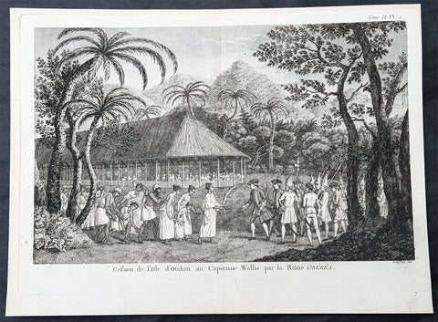
1774 Hawkesworth Antique Print Queen Purea Surrender to Capt Wallis Tahiti, 1767
- Title : Cession de lisle D otahiti au Capitaine Wallis par la Reine Oberea (Surrender of the Island of Taahiti to Capt Wallis by Queen Obera)
- Size: 14in x 10in (365mm x 255mm)
- Ref #: 16089-1
- Date : 1774
- Condition: (A) Very Good Condition
Description:
This fine original copper-plate engraved antique print of Captain Samuel Wallis - the first European to visit Tahiti in 1767 - accepting surrender from Queen Purea (Oberea) of Tahiti, after the battle in Matavia Bay in 1767, was engraved by Robert Benard and was published in the 1774 French edition of John Hawkesworths An Account of the Voyages Undertaken by the Order of His Present Majesty for Making Discoveries in the Southern Hemisphere and Successively Performed by Commodore Byron, Captain Wallis, Captain Carteret, and Captain Cook, in the Dolphin, the Swallow, and the Endeavor, Drawn Up from the Journals Which Were Kept by the Several Commanders, and from the Papers of Joseph Banks, Esq. Paris 1774
From the log of Samuel Wallis, Captain of The Dolphin 1767.......
At two in the morning, it being very clear, we made sail again; at day-break we saw the land, at about five leagues distance, and steered directly for it; but at eight o’clock, when we were close under it, the fog obliged us again to lie to, and when it cleared away, we were much surprised to find ourselves surrounded by some hundreds of canoes…. When they came within pistol shot of the ship, they lay by, gazing at us with great astonishment, and by turns conferring with each other. In the mean time we showed them trinkets of various kinds, and invited them on board. Soon after, they drew together, and held a kind of council, to determine what should be done: then they all paddled around the ship, making signs of friendship, and one of them holding up a branch of the plantain tree, made a speech that lasted near a quarter of an hour, and then threw it into the sea. Soon after, as we continued to make signs of invitation, a fine, stout, lively young man ventured on board: he came up by the mizzen chains, and jumped out of the shrouds on top of the awning. We made signs to him to come down upon the quarter-deck, and handed up some trinkets to him: he looked pleased, but would accept of nothing till some of the Indians came alongside, and after much talk, threw a few branches of plantain tree on board the ship. He then accepted our presents, and several others very soon came on board.
As we had no anchorage here, we stood along the shore, sending the boats at the same time to sound at a less distance…. About three o’clock in the afternoon, we brought to, abreast of a large bay, where there was an appearance of anchorage. The boats were immediately sent to sound it, and while they were thus employed, I observed a great number of canoes gather round them. I suspected that the Indians had a design to attack them, and as I was very desirous to prevent mischief, I made the signal for the boats to come aboard, and at the same time, to intimidate the Indians, I fired a nine-pounder over their heads. As soon as the cutter began to stand towards the ship, the Indians in their canoes, though they had been startled by the thunder of our nine-pounder, endeavoured to cut her off. The boat, however, sailing faster than the canoes could paddle, soon got clear of those that were about her; but some others, that were full of men, waylaid her in her course, and threw several stones into her, which wounded some of the people. Upon this, the officer on board fired a musquet, loaded with buck-shot, at the man who threw the first stone, and wounded him in the shoulder. The rest of the people in the canoes, as soon as they perceived their companion wounded, leapt in to the sea, and the other canoes paddled away, in great terror and confusion.
General Definitions:
Paper thickness and quality: - Heavy and stable
Paper color : - off white
Age of map color: -
Colors used: -
General color appearance: -
Paper size: - 14in x 10in (365mm x 255mm)
Plate size: - 14in x 10in (365mm x 255mm)
Margins: - Min 1/2in (12mm)
Imperfections:
Margins: - None
Plate area: - Folds as issued
Verso: - None
Background:
Samuel Wallis 1728 – 1795
was a British naval officer and explorer of the Pacific Ocean.
Wallis was born near Camelford, Cornwall. He served under John Byron, and in 1766 was promoted to captain and was given the command of HMS Dolphin (1751) as part of an expedition led by Philip Carteret in the Swallow with an assignment to circumnavigate the globe. The two ships were parted by a storm shortly after sailing through the Strait of Magellan, Wallis continuing to Tahiti, which he named King George the Thirds Island in honour of the King (June 1767). Wallis himself was ill and remained in his cabin: lieutenant Tobias Furneaux was the first to set foot, hoisting a pennant and turning a turf, taking possession in the name of His Majesty. Dolphin stayed in Matavai Bay in Tahiti for over a month. Wallis went on to name or rename five more islands in the Society Islands and six atolls in the Tuamotu Islands, as well as confirming the locations of Rongerik and Rongelap in the Marshall Islands. He renamed the Polynesian island of Uvea as Wallis after himself, before reaching Tinian in the Mariana Islands. He continued to Batavia, where many of the crew died from dysentery, then via the Cape of Good Hope to England, arriving in May 1768. He was able to pass on useful information to James Cook who was due to depart shortly for the Pacific, and some of the crew from the Dolphin sailed with Cook. In 1780 Wallis was appointed Commissioner of the Admiralty.
Tahiti previously also known as Otaheite is the largest island in the Windward group of French Polynesia. The island is located in the archipelago of the Society Islands in the central Southern Pacific Ocean.
The first European to have visited Tahiti according to existing records was lieutenant Samuel Wallis, who was circumnavigating the globe in HMS Dolphin, sighting the island on 18 June 1767, and eventually harboring in Matavai Bay. This bay was situated on the territory of the chiefdom of Pare-Arue, governed by Tu (Tu-nui-e-a a-i-te-Atua) and his regent Tutaha, and the chiefdom of Ha apape, governed by Amo and his wife Oberea (Purea). Wallis named the island King Georges Island. The first contacts were difficult, since on the 24 and 26 June 1767, Tahitian warriors in canoes showed aggression towards the British, hurling stones from their slings. In retaliation, the British sailors opened fire on the warriors in the canoes and on the hills. In reaction to this powerful counter-attack, the Tahitians laid down peace offerings for the British. Following this episode, Samuel Wallis was able to establish cordial relations with the female chieftain “Oberea “ (Purea) and remained on the island until 27 July 1767.
In July 1768, Captain James Cook was commissioned by the Royal Society and on orders from the Lords Commissioners of the Admiralty to observe the transit of Venus across the sun, a phenomenon that would be visible from Tahiti on 3 June 1769. He arrived in Tahitis Matavai Bay, commanding the HMS Endeavour on 12 April 1769. On 14 April, Cook met with Tutaha and Tepau. On 15 April, Cook picked the site for a fortified camp at Point Venus along with Banks, Parkinson, Daniel Solander, to protect Charles Greens observatory. The length of stay enabled them to undertake for the first time real ethnographic and scientific observations of the island. Assisted by the botanist Joseph Banks, and by the artist Sydney Parkinson, Cook gathered valuable information on the fauna and flora, as well as the native society, language and customs, including the proper name of the island, Otaheite. On 28 April, Cook met Purea and Tupaia, and Tupaia befriended Banks following the transit. On 21 June, Amo visited Cook, and then on 25 June, Pohuetea visited, signifying another chief seeking to ally himself with the British.
Cook and Banks circumnavigated the island from 26 June to 1 July. On the exploration, they met Ahio, chief of Ha apaiano o or Papenoo, Rita, chief of Hitia a, Pahairro, chief of Pueu, Vehiatua, chief of Tautra, Matahiapo, chief of Teahupo o, Tutea, chief of Vaira o, and Moe, chief of Afa Ahiti. In Papara, guided by Tupaia, they investigated the ruins of Mahaiatea marae, an impressive structure containing a stone pyramid or ahu, measuring 44 feet high, 267 feet long and 87 feet wide. Cook and the Endeavour departed Tahiti on 13 July 1769, taking Raiatean navigator Tupaia along for his geographic knowledge of the islands.
Cook returned to Tahiti between 15 August and 1 September 1773, greeted by the chiefs Tai and Puhi, besides the youg ari i Vehiatua II and his stepfather Ti itorea. Cook anchored in Vaitepiha Bay before returning to Point Venus where he met Tu, the paramount chief. Cook picked up two passengers from Tahiti during this trip, Porea and Mai, with Hitihiti later replacing Porea when Cook stopped at Raiatea. Cook took Hitihiti to Tahiti on 22 April, during his return leg. Then, Cook departed Tahiti on 14 May 1774.
During his final visit, Cook returned Mai to Tahiti on 12 Aug. 1777, after Mais long visit in England. Cook also brought two Maori from Queen Charlotte Sound, Te Weherua and Koa. Cook first harbored in Vaitepiha Bay, where he visited Vehiatua II s funeral bier and the prefabricated Spanish mission house. Cook also met Vehiatua III, and inscribed on the back of the Spanish cross, Georgius tertius Rex Annis 1767, 69, 73, 74 & 77, as a counterpoint to Christus Vincit Carolus III imperat 1774 on the front. On 23 Aug., Cook sailed for Matavai Bay, where he met Tu, his father Teu, his mother Tetupaia, his brothers Ari ipaea and Vaetua, and his sisters Ari ipaea-vahine, Tetua-te-ahamai, and Auo. Cook also observed a human sacrifice, taata tapu, at the Utu-ai-mahurau marae, and 49 skulls from previous victims.
On 29 Sept. 1777, Cook sailed for Papetoai Bay on Moorea. Cook met Mahine in an act of friendship on 3 Oct., though he was an enemy of Tu. When a goat kid was stolen on 6 Oct., Cook in a rampage, ordered the burning of houses and canoes until it was returned. Cook sailed for Huahine on 11 Oct., Raiatea on 2 Nov., and Borabora on 7 Dec.
On 26 October 1788, HMS Bounty, under the command of Captain William Bligh, landed in Tahiti with the mission of carrying Tahitian breadfruit trees (Tahitian: uru) to the Caribbean. Sir Joseph Banks, the botanist from James Cooks first expedition, had concluded that this plant would be ideal to feed the African slaves working in the Caribbean plantations at very little cost. The crew remained in Tahiti for about five months, the time needed to transplant the seedlings of the trees. Three weeks after leaving Tahiti, on 28 April 1789, the crew mutinied on the initiative of Fletcher Christian. The mutineers seized the ship and set the captain and most of those members of the crew who remained loyal to him adrift in a ships boat. A group of mutineers then went back to settle in Tahiti.
Although various explorers had refused to get involved in tribal conflicts, the mutineers from the Bounty offered their services as mercenaries and furnished arms to the family which became the Pōmare Dynasty. The chief Tū knew how to use their presence in the harbours favoured by sailors to his advantage. As a result of his alliance with the mutineers, he succeeded in considerably increasing his supremacy over the island of Tahiti.
Robert Bénard 1734 – 1777 was an 18th-century French engraver.
Specialized in the technique of engraving, Robert Ménard is mainly famous for having supplied a significant amount of plates (at least 1,800) to the Encyclopédie by Diderot & d\'Alembert from 1751.
Later, publisher Charles-Joseph Panckoucke reused many of his productions to illustrate the works of his catalog.
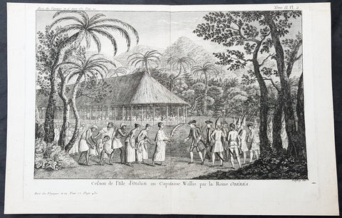
1774 Hawkesworth Antique Print Queen Purea Surrender to Capt Wallis Tahiti, 1767
- Title : Cession de lisle D otahiti au Capitaine Wallis par la Reine Oberea (Surrender of the Island of Taahiti to Capt Wallis by Queen Obera)
- Size: 14in x 10in (365mm x 255mm)
- Ref #: 25925
- Date : 1774
- Condition: (A) Very Good Condition
Description:
This fine original copper-plate engraved antique print of Captain Samuel Wallis - the first European to visit Tahiti in 1767 - accepting surrender from Queen Purea (Oberea) of Tahiti, after the battle in Matavia Bay in 1767, was engraved by Robert Benard and was published in the 1774 French edition of John Hawkesworths An Account of the Voyages Undertaken by the Order of His Present Majesty for Making Discoveries in the Southern Hemisphere and Successively Performed by Commodore Byron, Captain Wallis, Captain Carteret, and Captain Cook, in the Dolphin, the Swallow, and the Endeavor, Drawn Up from the Journals Which Were Kept by the Several Commanders, and from the Papers of Joseph Banks, Esq. Paris 1774
From the log of Samuel Wallis, Captain of The Dolphin 1767.......
At two in the morning, it being very clear, we made sail again; at day-break we saw the land, at about five leagues distance, and steered directly for it; but at eight o’clock, when we were close under it, the fog obliged us again to lie to, and when it cleared away, we were much surprised to find ourselves surrounded by some hundreds of canoes…. When they came within pistol shot of the ship, they lay by, gazing at us with great astonishment, and by turns conferring with each other. In the mean time we showed them trinkets of various kinds, and invited them on board. Soon after, they drew together, and held a kind of council, to determine what should be done: then they all paddled around the ship, making signs of friendship, and one of them holding up a branch of the plantain tree, made a speech that lasted near a quarter of an hour, and then threw it into the sea. Soon after, as we continued to make signs of invitation, a fine, stout, lively young man ventured on board: he came up by the mizzen chains, and jumped out of the shrouds on top of the awning. We made signs to him to come down upon the quarter-deck, and handed up some trinkets to him: he looked pleased, but would accept of nothing till some of the Indians came alongside, and after much talk, threw a few branches of plantain tree on board the ship. He then accepted our presents, and several others very soon came on board.
As we had no anchorage here, we stood along the shore, sending the boats at the same time to sound at a less distance…. About three o’clock in the afternoon, we brought to, abreast of a large bay, where there was an appearance of anchorage. The boats were immediately sent to sound it, and while they were thus employed, I observed a great number of canoes gather round them. I suspected that the Indians had a design to attack them, and as I was very desirous to prevent mischief, I made the signal for the boats to come aboard, and at the same time, to intimidate the Indians, I fired a nine-pounder over their heads. As soon as the cutter began to stand towards the ship, the Indians in their canoes, though they had been startled by the thunder of our nine-pounder, endeavoured to cut her off. The boat, however, sailing faster than the canoes could paddle, soon got clear of those that were about her; but some others, that were full of men, waylaid her in her course, and threw several stones into her, which wounded some of the people. Upon this, the officer on board fired a musquet, loaded with buck-shot, at the man who threw the first stone, and wounded him in the shoulder. The rest of the people in the canoes, as soon as they perceived their companion wounded, leapt in to the sea, and the other canoes paddled away, in great terror and confusion.
General Definitions:
Paper thickness and quality: - Heavy and stable
Paper color : - off white
Age of map color: -
Colors used: -
General color appearance: -
Paper size: - 14in x 10in (365mm x 255mm)
Plate size: - 14in x 10in (365mm x 255mm)
Margins: - Min 1/2in (12mm)
Imperfections:
Margins: - None
Plate area: - Folds as issued
Verso: - None
Background:
Samuel Wallis 1728 – 1795
was a British naval officer and explorer of the Pacific Ocean.
Wallis was born near Camelford, Cornwall. He served under John Byron, and in 1766 was promoted to captain and was given the command of HMS Dolphin (1751) as part of an expedition led by Philip Carteret in the Swallow with an assignment to circumnavigate the globe. The two ships were parted by a storm shortly after sailing through the Strait of Magellan, Wallis continuing to Tahiti, which he named King George the Thirds Island in honour of the King (June 1767). Wallis himself was ill and remained in his cabin: lieutenant Tobias Furneaux was the first to set foot, hoisting a pennant and turning a turf, taking possession in the name of His Majesty. Dolphin stayed in Matavai Bay in Tahiti for over a month. Wallis went on to name or rename five more islands in the Society Islands and six atolls in the Tuamotu Islands, as well as confirming the locations of Rongerik and Rongelap in the Marshall Islands. He renamed the Polynesian island of Uvea as Wallis after himself, before reaching Tinian in the Mariana Islands. He continued to Batavia, where many of the crew died from dysentery, then via the Cape of Good Hope to England, arriving in May 1768. He was able to pass on useful information to James Cook who was due to depart shortly for the Pacific, and some of the crew from the Dolphin sailed with Cook. In 1780 Wallis was appointed Commissioner of the Admiralty.
Tahiti previously also known as Otaheite is the largest island in the Windward group of French Polynesia. The island is located in the archipelago of the Society Islands in the central Southern Pacific Ocean.
The first European to have visited Tahiti according to existing records was lieutenant Samuel Wallis, who was circumnavigating the globe in HMS Dolphin, sighting the island on 18 June 1767, and eventually harboring in Matavai Bay. This bay was situated on the territory of the chiefdom of Pare-Arue, governed by Tu (Tu-nui-e-a a-i-te-Atua) and his regent Tutaha, and the chiefdom of Ha apape, governed by Amo and his wife Oberea (Purea). Wallis named the island King Georges Island. The first contacts were difficult, since on the 24 and 26 June 1767, Tahitian warriors in canoes showed aggression towards the British, hurling stones from their slings. In retaliation, the British sailors opened fire on the warriors in the canoes and on the hills. In reaction to this powerful counter-attack, the Tahitians laid down peace offerings for the British. Following this episode, Samuel Wallis was able to establish cordial relations with the female chieftain “Oberea “ (Purea) and remained on the island until 27 July 1767.
In July 1768, Captain James Cook was commissioned by the Royal Society and on orders from the Lords Commissioners of the Admiralty to observe the transit of Venus across the sun, a phenomenon that would be visible from Tahiti on 3 June 1769. He arrived in Tahitis Matavai Bay, commanding the HMS Endeavour on 12 April 1769. On 14 April, Cook met with Tutaha and Tepau. On 15 April, Cook picked the site for a fortified camp at Point Venus along with Banks, Parkinson, Daniel Solander, to protect Charles Greens observatory. The length of stay enabled them to undertake for the first time real ethnographic and scientific observations of the island. Assisted by the botanist Joseph Banks, and by the artist Sydney Parkinson, Cook gathered valuable information on the fauna and flora, as well as the native society, language and customs, including the proper name of the island, Otaheite. On 28 April, Cook met Purea and Tupaia, and Tupaia befriended Banks following the transit. On 21 June, Amo visited Cook, and then on 25 June, Pohuetea visited, signifying another chief seeking to ally himself with the British.
Cook and Banks circumnavigated the island from 26 June to 1 July. On the exploration, they met Ahio, chief of Ha apaiano o or Papenoo, Rita, chief of Hitia a, Pahairro, chief of Pueu, Vehiatua, chief of Tautra, Matahiapo, chief of Teahupo o, Tutea, chief of Vaira o, and Moe, chief of Afa Ahiti. In Papara, guided by Tupaia, they investigated the ruins of Mahaiatea marae, an impressive structure containing a stone pyramid or ahu, measuring 44 feet high, 267 feet long and 87 feet wide. Cook and the Endeavour departed Tahiti on 13 July 1769, taking Raiatean navigator Tupaia along for his geographic knowledge of the islands.
Cook returned to Tahiti between 15 August and 1 September 1773, greeted by the chiefs Tai and Puhi, besides the youg ari i Vehiatua II and his stepfather Ti itorea. Cook anchored in Vaitepiha Bay before returning to Point Venus where he met Tu, the paramount chief. Cook picked up two passengers from Tahiti during this trip, Porea and Mai, with Hitihiti later replacing Porea when Cook stopped at Raiatea. Cook took Hitihiti to Tahiti on 22 April, during his return leg. Then, Cook departed Tahiti on 14 May 1774.
During his final visit, Cook returned Mai to Tahiti on 12 Aug. 1777, after Mais long visit in England. Cook also brought two Maori from Queen Charlotte Sound, Te Weherua and Koa. Cook first harbored in Vaitepiha Bay, where he visited Vehiatua II s funeral bier and the prefabricated Spanish mission house. Cook also met Vehiatua III, and inscribed on the back of the Spanish cross, Georgius tertius Rex Annis 1767, 69, 73, 74 & 77, as a counterpoint to Christus Vincit Carolus III imperat 1774 on the front. On 23 Aug., Cook sailed for Matavai Bay, where he met Tu, his father Teu, his mother Tetupaia, his brothers Ari ipaea and Vaetua, and his sisters Ari ipaea-vahine, Tetua-te-ahamai, and Auo. Cook also observed a human sacrifice, taata tapu, at the Utu-ai-mahurau marae, and 49 skulls from previous victims.
On 29 Sept. 1777, Cook sailed for Papetoai Bay on Moorea. Cook met Mahine in an act of friendship on 3 Oct., though he was an enemy of Tu. When a goat kid was stolen on 6 Oct., Cook in a rampage, ordered the burning of houses and canoes until it was returned. Cook sailed for Huahine on 11 Oct., Raiatea on 2 Nov., and Borabora on 7 Dec.
On 26 October 1788, HMS Bounty, under the command of Captain William Bligh, landed in Tahiti with the mission of carrying Tahitian breadfruit trees (Tahitian: uru) to the Caribbean. Sir Joseph Banks, the botanist from James Cooks first expedition, had concluded that this plant would be ideal to feed the African slaves working in the Caribbean plantations at very little cost. The crew remained in Tahiti for about five months, the time needed to transplant the seedlings of the trees. Three weeks after leaving Tahiti, on 28 April 1789, the crew mutinied on the initiative of Fletcher Christian. The mutineers seized the ship and set the captain and most of those members of the crew who remained loyal to him adrift in a ships boat. A group of mutineers then went back to settle in Tahiti.
Although various explorers had refused to get involved in tribal conflicts, the mutineers from the Bounty offered their services as mercenaries and furnished arms to the family which became the Pōmare Dynasty. The chief Tū knew how to use their presence in the harbours favoured by sailors to his advantage. As a result of his alliance with the mutineers, he succeeded in considerably increasing his supremacy over the island of Tahiti.
Robert Bénard 1734 – 1777 was an 18th-century French engraver.
Specialized in the technique of engraving, Robert Ménard is mainly famous for having supplied a significant amount of plates (at least 1,800) to the Encyclopédie by Diderot & d\'Alembert from 1751.
Later, publisher Charles-Joseph Panckoucke reused many of his productions to illustrate the works of his catalog.
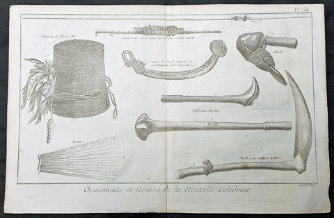
1778 Capt. Cook Antique Print Weapons Tools Hats from New Caledonia - Cook 1774
- Title : Ornemens et Armes de la Nouvelle Caledonie
- Size: 14 1/2in x 9 1/2in (370mm x 240mm)
- Ref #: 21617
- Date : 1778
- Condition: (A) Very Good Condition
Description:
This large original copper-plate engraved antique print of various weapons, farming tools and ornaments from the New Caledonia Islands visited by Captain James Cook in September 1774, in HMS Resolution & Adventure, during his 2nd Voyage of Discovery to the South Seas, was engraved by Robert Benard - after William Hodges - and was published in the 1778 French edition of Capt. James Cooks 2nd Voyage of Discovery to the South Seas A voyage towards the South Pole, and round the World. Performed in His Majestys ships the Resolution and Adventure, in the years 1772, 1773, 1774, and 1775..... Paris : Hotel de Thou ......1778.
The items illustrated are;
1. Lanee - Lance
2. Partie ornee de la Lance sur une plus grande Echelle - Larger scale of Lance handle
3. Chapeau de plumes &c. - Hat with feathers
4. Peigne - Comb
5. Piece de Corde dont ils se servent pour jetter leurs lances - Cord used to launch a spear
6 & 7. Differentes Massues - Two different types of club
8. Pioche pour Cultiver la Terre - Wooden farming hoe
9. Hache - Axe
General Definitions:
Paper thickness and quality: - Heavy and stable
Paper color : - off white
Age of map color: -
Colors used: -
General color appearance: -
Paper size: - 14 1/2in x 9 1/2in (370mm x 240mm)
Plate size: - 14 1/2in x 9 1/2in (370mm x 240mm)
Margins: - Min 1/2in (12mm)
Imperfections:
Margins: - None
Plate area: - None
Verso: - None
Background:
New Caledonia is a special collective of France in the southwest Pacific Ocean, 1,210 km east of Australia and 20,000 km from Metropolitan France. The archipelago, part of the Melanesia sub-region, includes the main island of Grande Terre, the Loyalty Islands, the Chesterfield Islands, the Belep archipelago, the Isle of Pines, and a few remote islets. The Chesterfield Islands are in the Coral Sea. Locals refer to Grande Terre as Le Caillou (the pebble)
British explorer Captain James Cook was the first European to sight New Caledonia, on 4 September 1774, during his second voyage. He named it New Caledonia, as the northeast of the island reminded him of Scotland. The west coast of Grande Terre was approached by Jean-François de Galaup, comte de Lapérouse in 1788, shortly before his disappearance, and the Loyalty Islands were first visited between 1793 and 1796 when Mare, Lifou, Tiga, and Ouvea were mapped by William Raven. The American whaler encountered the island named then Britania, and today known as Mar (Loyalty Is.) in November 1793. From 1796 until 1840, only a few sporadic contacts with the archipelago were recorded. About fifty American whalers (identified by Robert Langsom from their log books) have been recorded in the region (Grande Terre, Loyalty Is., Walpole and Hunter) between 1793 and 1887. Contacts became more frequent after 1840, because of the interest in sandalwood
William Hodges RA 1744 – 1797 was an English painter. He was a member of James Cooks second voyage to the Pacific Ocean, and is best known for the sketches and paintings of locations he visited on that voyage, including Table Bay, Tahiti, Easter Island, and the Antarctic.
Between 1772 and 1775 Hodges accompanied James Cook to the Pacific as the expeditions artist. Many of his sketches and wash paintings were adapted as engravings in the original published edition of Cooks journals from the voyage.
Most of the large-scale landscape oil paintings from his Pacific travels for which Hodges is best known were finished after his return to London; he received a salary from the Admiralty for the purposes of completing them. These paintings depicted a stronger light and shadow than had been usual in European landscape tradition. Contemporary art critics complained that his use of light and colour contrasts gave his paintings a rough and unfinished appearance.
Hodges also produced many valuable portrait sketches of Pacific islanders and scenes from the voyage involving members of the expedition..
Robert Bénard 1734 – 1777 was an 18th-century French engraver.
Specialized in the technique of engraving, Robert Ménard is mainly famous for having supplied a significant amount of plates (at least 1,800) to the Encyclopédie by Diderot & d\'Alembert from 1751.
Later, publisher Charles-Joseph Panckoucke reused many of his productions to illustrate the works of his catalog.
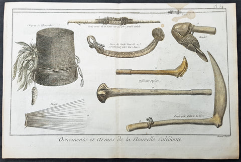
1778 Capt. Cook Antique Print Weapons Tools Hats from New Caledonia - Cook 1774
- Title : Ornemens et Armes de la Nouvelle Caledonie
- Size: 15in x 10in (380mm x 255mm)
- Ref #: 16362
- Date : 1778
- Condition: (A) Very Good Condition
Description:
This large original copper-plate engraved antique print of various weapons, farming tools and ornaments from the New Caledonia Islands visited by Captain James Cook in September 1774, in HMS Resolution & Adventure, during his 2nd Voyage of Discovery to the South Seas, was engraved by Robert Benard - after William Hodges - and was published in the 1778 French edition of Capt. James Cooks 2nd Voyage of Discovery to the South Seas A voyage towards the South Pole, and round the World. Performed in His Majestys ships the Resolution and Adventure, in the years 1772, 1773, 1774, and 1775..... Paris : Hotel de Thou ......1778.
The items illustrated are;
1. Lanee - Lance
2. Partie ornee de la Lance sur une plus grande Echelle - Larger scale of Lance handle
3. Chapeau de plumes &c. - Hat with feathers
4. Peigne - Comb
5. Piece de Corde dont ils se servent pour jetter leurs lances - Cord used to launch a spear
6 & 7. Differentes Massues - Two different types of club
8. Pioche pour Cultiver la Terre - Wooden farming hoe
9. Hache - Axe
General Definitions:
Paper thickness and quality: - Heavy and stable
Paper color : - off white
Age of map color: - Early
Colors used: - Yellow
General color appearance: - Authentic
Paper size: - 15in x 10in (380mm x 255mm)
Plate size: - 14 1/2in x 9 1/2in (370mm x 240mm)
Margins: - Min 1/2in (12mm)
Imperfections:
Margins: - Brown spotting to top of image
Plate area: - None
Verso: - None
Background:
New Caledonia is a special collective of France in the southwest Pacific Ocean, 1,210 km east of Australia and 20,000 km from Metropolitan France. The archipelago, part of the Melanesia sub-region, includes the main island of Grande Terre, the Loyalty Islands, the Chesterfield Islands, the Belep archipelago, the Isle of Pines, and a few remote islets. The Chesterfield Islands are in the Coral Sea. Locals refer to Grande Terre as Le Caillou (the pebble)
British explorer Captain James Cook was the first European to sight New Caledonia, on 4 September 1774, during his second voyage. He named it New Caledonia, as the northeast of the island reminded him of Scotland. The west coast of Grande Terre was approached by Jean-François de Galaup, comte de Lapérouse in 1788, shortly before his disappearance, and the Loyalty Islands were first visited between 1793 and 1796 when Mare, Lifou, Tiga, and Ouvea were mapped by William Raven. The American whaler encountered the island named then Britania, and today known as Mar (Loyalty Is.) in November 1793. From 1796 until 1840, only a few sporadic contacts with the archipelago were recorded. About fifty American whalers (identified by Robert Langsom from their log books) have been recorded in the region (Grande Terre, Loyalty Is., Walpole and Hunter) between 1793 and 1887. Contacts became more frequent after 1840, because of the interest in sandalwood
William Hodges RA 1744 – 1797 was an English painter. He was a member of James Cooks second voyage to the Pacific Ocean, and is best known for the sketches and paintings of locations he visited on that voyage, including Table Bay, Tahiti, Easter Island, and the Antarctic.
Between 1772 and 1775 Hodges accompanied James Cook to the Pacific as the expeditions artist. Many of his sketches and wash paintings were adapted as engravings in the original published edition of Cooks journals from the voyage.
Most of the large-scale landscape oil paintings from his Pacific travels for which Hodges is best known were finished after his return to London; he received a salary from the Admiralty for the purposes of completing them. These paintings depicted a stronger light and shadow than had been usual in European landscape tradition. Contemporary art critics complained that his use of light and colour contrasts gave his paintings a rough and unfinished appearance.
Hodges also produced many valuable portrait sketches of Pacific islanders and scenes from the voyage involving members of the expedition..
Robert Bénard 1734 – 1777 was an 18th-century French engraver.
Specialized in the technique of engraving, Robert Ménard is mainly famous for having supplied a significant amount of plates (at least 1,800) to the Encyclopédie by Diderot & d\'Alembert from 1751.
Later, publisher Charles-Joseph Panckoucke reused many of his productions to illustrate the works of his catalog.
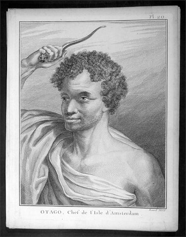
1785 Capt. Cook Antique Print of Chief Otago of Tongatapu, Tonga Islands in 1777
- Title : Otago, Chef de L Isle d Amersterdam
- Ref : 16358
- Size: 10in x 8in (255mm x 205mm)
- Date : 1785
- Condition: (A+) Fine Condition
Description:
This fine original copper-plate engraved antique print of Otago, Chief of the Island of Tongatapu (Amsterdam) the largest island in the Tonga Island, drawn during a visit by Captain Cook in 1777, during his 3rd and last Voyage of Discovery, was engraved by Robert Benard - after Cooks on-board artist, John Webber - and was published in the 1785 French edition of Capt. James Cook & Capt. James King A Voyage to the Pacific Ocean. Undertaken, by the Command of his Majesty, for making Discoveries in the Northern Hemisphere. To determine The Position and Extent of the West Side of North America; its Distance from Asia; and the Practicability of a Northen Passage to Europe. Performed under the direction of Captains Cook, Clerke, and Gore, In His Majesty\'s Ships the Resolution and Discovery. In the Years 1776, 1777, 1778, 1779, and 1780. In Three Volumes. Vol. I and II written by James Cook, F.R.S. Vol. III by Captain James King, LL.D. and F.R.S. Paris, 1785.
General Definitions:
Paper thickness and quality: - Heavy and stable
Paper color : - off white
Age of map color: -
Colors used: -
General color appearance: -
Paper size: - 10in x 8in (255mm x 205mm)
Plate size: - 9 1/2in x 7 1/4in (240mm x 185mm)
Margins: - Min 1/2in (12mm)
Imperfections:
Margins: - Light soiling in margins
Plate area: - None
Verso: - None
Background:
Tonga officially the Kingdom of Tonga, is a Polynesian sovereign state and archipelago comprising 169 islands, of which 36 are inhabited. The total surface area is about 750 square kilometres (290 sq mi) scattered over 700,000 square kilometres (270,000 sq mi) of the southern Pacific Ocean. It has a population of 107,122 people, of whom 70% reside on the main island of Tongatapu.
The Tongan people first encountered Europeans in 1616 when the Dutch vessel Eendracht, captained by Willem Schouten, made a short visit to trade. Later came other Dutch explorers, including Jacob Le Maire (who called on the northern island of Niuatoputapu); and in 1643 Abel Tasman (who visited Tongatapu and Haapai).
Later noteworthy European visitors included James Cook (Royal Navy) in 1773, 1774, and 1777; Alessandro Malaspina (Spanish Navy) in 1793; the first London missionaries in 1797; and the Wesleyan Methodist Reverend Walter Lawry in 1822.
Tonga became known in the West as the Friendly Islands because of the congenial reception accorded to Captain James Cook on his first visit in 1773. He arrived at the time of the inasi festival, the yearly donation of the First Fruits to the Tui Tonga (the islands paramount chief) and so received an invitation to the festivities. According to the writer William Mariner, the chiefs wanted to kill Cook during the gathering but could not agree on a plan.
Captain James King FRS 1750 – 1784 was an officer of the Royal Navy. He served under James Cook on his last voyage around the world, specialising in taking important astronomical readings using a sextant. After Cook died he helped lead the ships on the remainder of their course, also completing Cook\\\'s account of the voyage. He continued his career in the Navy, reaching the rank of post-captain, commanding several ships and serving in the American War of Independence.
King joined HMS Resolution as second lieutenant, sharing the duties of astronomer with Cook, taking astronomical observations on board by sextant and with Larcum Kendals timekeeper K1, to establish the Resolutions position at sea and on shore by sextant or by astronomical quadrant to establish the geographical position of salient points during the course of Cooks surveys. Thus King\\\'s geographical positions were an important contribution to the accuracy of the various surveys carried out during the voyage and his use of the early chronometers helped prove their use at sea for calculation of Longitude. .
Following the death of Cook, King remained in the Resolution but on the death of Charles Clerke, Cooks successor, King was appointed to command HMS Discovery, the Resolution\\\'s consort, remaining in her for the rest of the voyage. After his return to England King was very much involved in the publication of the official account of Cooks third voyage, writing the third volume at Woodstock, near Oxford, where his brother Thomas was rector of St Mary Magdalene. But shortly after his return King was promoted Post-captain and appointed commander of HMS Crocodile in the English Channel.
John Webber RA 1751 – 1793 was an English artist who accompanied Captain Cook on his third Pacific expedition. He is best known for his images of Australasia, Hawaii and Alaska.
Webber was born in London, educated in Bern and studied painting at Paris.His father was Abraham Wäber, a Swiss sculptor who had moved to London, and changed his name to Webber before marrying a Mrs Mary Quant in 1744.
Webber served as official artist on James Cook\'s third voyage of discovery around the Pacific (1776–80) aboard HMS Resolution. At Adventure Bay in January 1777 he did drawings of A Man of Van Diemens Land and A Woman of Van Diemens Land. He also did many drawings of scenes in New Zealand and the South Sea islands. On this voyage, during which Cook lost his life in a fight in Hawaii, Webber became the first European artist to make contact with Hawaii, then called the Sandwich Islands. He made numerous watercolor landscapes of the islands of Kauai and Hawaii, and also portrayed many of the Hawaiian people.
In April 1778, Captain Cooks ships Resolution and Discovery anchored at Ship Cove, now known as Nootka Sound, Vancouver Island, Canada to refit. The crew took observations and recorded encounters with the local people. Webber made watercolour landscapes including Resolution and Discovery in Ship Cove, 1778. His drawings and paintings were engraved for British Admiraltys account of the expedition, which was published in 1784.
Back in England in 1780 Webber exhibited around 50 works at Royal Academy exhibitions between 1784 and 1792, and was elected an associate of the Royal Academy in 1785 and R.A. in 1791. Most of his work were landscapes. Sometimes figures were included as in A Party from H.M.S. Resolution shooting sea horses\", which was shown at the academy in 1784, and his The Death of Captain Cook became well known through an engraving of it. Another version of this picture is in the William Dixson gallery at Sydney
Robert Bénard 1734 – 1777 was an 18th-century French engraver.
Specialized in the technique of engraving, Robert Ménard is mainly famous for having supplied a significant amount of plates (at least 1,800) to the Encyclopédie by Diderot & d\'Alembert from 1751.
Later, publisher Charles-Joseph Panckoucke reused many of his productions to illustrate the works of his catalog.
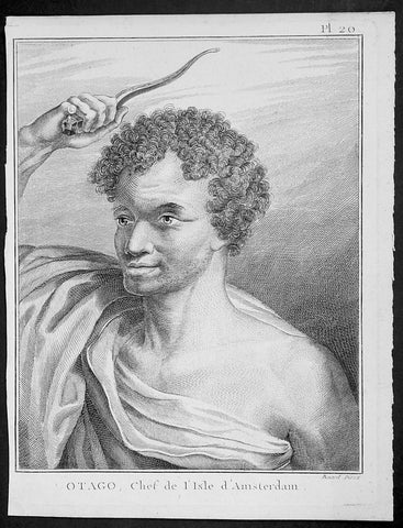
1785 Capt. Cook Antique Print of Chief Otago of Tongatapu, Tonga Islands in 1777
- Title : Otago, Chef de L Isle d Amersterdam
- Ref : 91220
- Size: 10in x 8in (255mm x 205mm)
- Date : 1785
- Condition: (A+) Fine Condition
Description:
This fine original copper-plate engraved antique print of Otago, Chief of the Island of Tongatapu (Amsterdam) the largest island in the Tonga Island, drawn during a visit by Captain Cook in 1777, during his 3rd and last Voyage of Discovery, was engraved by Robert Benard - after Cooks on-board artist, John Webber - and was published in the 1785 French edition of Capt. James Cook & Capt. James King A Voyage to the Pacific Ocean. Undertaken, by the Command of his Majesty, for making Discoveries in the Northern Hemisphere. To determine The Position and Extent of the West Side of North America; its Distance from Asia; and the Practicability of a Northen Passage to Europe. Performed under the direction of Captains Cook, Clerke, and Gore, In His Majesty\'s Ships the Resolution and Discovery. In the Years 1776, 1777, 1778, 1779, and 1780. In Three Volumes. Vol. I and II written by James Cook, F.R.S. Vol. III by Captain James King, LL.D. and F.R.S. Paris, 1785.
General Definitions:
Paper thickness and quality: - Heavy and stable
Paper color : - off white
Age of map color: -
Colors used: -
General color appearance: -
Paper size: - 10in x 8in (255mm x 205mm)
Plate size: - 9 1/2in x 7 1/4in (240mm x 185mm)
Margins: - Min 1/2in (12mm)
Imperfections:
Margins: - Light soiling in margins
Plate area: - None
Verso: - None
Background:
Tonga officially the Kingdom of Tonga, is a Polynesian sovereign state and archipelago comprising 169 islands, of which 36 are inhabited. The total surface area is about 750 square kilometres (290 sq mi) scattered over 700,000 square kilometres (270,000 sq mi) of the southern Pacific Ocean. It has a population of 107,122 people, of whom 70% reside on the main island of Tongatapu.
The Tongan people first encountered Europeans in 1616 when the Dutch vessel Eendracht, captained by Willem Schouten, made a short visit to trade. Later came other Dutch explorers, including Jacob Le Maire (who called on the northern island of Niuatoputapu); and in 1643 Abel Tasman (who visited Tongatapu and Haapai).
Later noteworthy European visitors included James Cook (Royal Navy) in 1773, 1774, and 1777; Alessandro Malaspina (Spanish Navy) in 1793; the first London missionaries in 1797; and the Wesleyan Methodist Reverend Walter Lawry in 1822.
Tonga became known in the West as the Friendly Islands because of the congenial reception accorded to Captain James Cook on his first visit in 1773. He arrived at the time of the inasi festival, the yearly donation of the First Fruits to the Tui Tonga (the islands paramount chief) and so received an invitation to the festivities. According to the writer William Mariner, the chiefs wanted to kill Cook during the gathering but could not agree on a plan.
Captain James King FRS 1750 – 1784 was an officer of the Royal Navy. He served under James Cook on his last voyage around the world, specialising in taking important astronomical readings using a sextant. After Cook died he helped lead the ships on the remainder of their course, also completing Cook\\\'s account of the voyage. He continued his career in the Navy, reaching the rank of post-captain, commanding several ships and serving in the American War of Independence.
King joined HMS Resolution as second lieutenant, sharing the duties of astronomer with Cook, taking astronomical observations on board by sextant and with Larcum Kendals timekeeper K1, to establish the Resolutions position at sea and on shore by sextant or by astronomical quadrant to establish the geographical position of salient points during the course of Cooks surveys. Thus King\\\'s geographical positions were an important contribution to the accuracy of the various surveys carried out during the voyage and his use of the early chronometers helped prove their use at sea for calculation of Longitude. .
Following the death of Cook, King remained in the Resolution but on the death of Charles Clerke, Cooks successor, King was appointed to command HMS Discovery, the Resolution\\\'s consort, remaining in her for the rest of the voyage. After his return to England King was very much involved in the publication of the official account of Cooks third voyage, writing the third volume at Woodstock, near Oxford, where his brother Thomas was rector of St Mary Magdalene. But shortly after his return King was promoted Post-captain and appointed commander of HMS Crocodile in the English Channel.
John Webber RA 1751 – 1793 was an English artist who accompanied Captain Cook on his third Pacific expedition. He is best known for his images of Australasia, Hawaii and Alaska.
Webber was born in London, educated in Bern and studied painting at Paris.His father was Abraham Wäber, a Swiss sculptor who had moved to London, and changed his name to Webber before marrying a Mrs Mary Quant in 1744.
Webber served as official artist on James Cook\'s third voyage of discovery around the Pacific (1776–80) aboard HMS Resolution. At Adventure Bay in January 1777 he did drawings of A Man of Van Diemens Land and A Woman of Van Diemens Land. He also did many drawings of scenes in New Zealand and the South Sea islands. On this voyage, during which Cook lost his life in a fight in Hawaii, Webber became the first European artist to make contact with Hawaii, then called the Sandwich Islands. He made numerous watercolor landscapes of the islands of Kauai and Hawaii, and also portrayed many of the Hawaiian people.
In April 1778, Captain Cooks ships Resolution and Discovery anchored at Ship Cove, now known as Nootka Sound, Vancouver Island, Canada to refit. The crew took observations and recorded encounters with the local people. Webber made watercolour landscapes including Resolution and Discovery in Ship Cove, 1778. His drawings and paintings were engraved for British Admiraltys account of the expedition, which was published in 1784.
Back in England in 1780 Webber exhibited around 50 works at Royal Academy exhibitions between 1784 and 1792, and was elected an associate of the Royal Academy in 1785 and R.A. in 1791. Most of his work were landscapes. Sometimes figures were included as in A Party from H.M.S. Resolution shooting sea horses\", which was shown at the academy in 1784, and his The Death of Captain Cook became well known through an engraving of it. Another version of this picture is in the William Dixson gallery at Sydney
Robert Bénard 1734 – 1777 was an 18th-century French engraver.
Specialized in the technique of engraving, Robert Ménard is mainly famous for having supplied a significant amount of plates (at least 1,800) to the Encyclopédie by Diderot & d\'Alembert from 1751.
Later, publisher Charles-Joseph Panckoucke reused many of his productions to illustrate the works of his catalog.
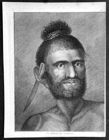
1785 Capt. Cook Antique Print - A Man of Mangaia Island, Cook Islands in 1777
- Title : Un Homme De Mangea
- Ref : 31845
- Size: 10in x 8in (255mm x 205mm)
- Date : 1785
- Condition: (A+) Fine Condition
Description:
This fine original copper-plate engraved antique print of a man from Mangaia (Mangea) Island of the Cook Islands in the South Pacific, during a visit by Cook in 1777, during his 3rd and last Voyage of Discovery, was engraved by Robert Benard - after Cooks on-board artist, John Webber - and was published in the 1785 French edition of Capt. James Cook & Capt. James King A Voyage to the Pacific Ocean. Undertaken, by the Command of his Majesty, for making Discoveries in the Northern Hemisphere. To determine The Position and Extent of the West Side of North America; its Distance from Asia; and the Practicability of a Northen Passage to Europe. Performed under the direction of Captains Cook, Clerke, and Gore, In His Majesty\'s Ships the Resolution and Discovery. In the Years 1776, 1777, 1778, 1779, and 1780. In Three Volumes. Vol. I and II written by James Cook, F.R.S. Vol. III by Captain James King, LL.D. and F.R.S. Paris, 1785.
General Definitions:
Paper thickness and quality: - Heavy and stable
Paper color : - off white
Age of map color: -
Colors used: -
General color appearance: -
Paper size: - 10in x 8in (255mm x 205mm)
Plate size: - 9 1/2in x 7 1/4in (240mm x 185mm)
Margins: - Min 1/2in (12mm)
Imperfections:
Margins: - Light soiling in margins
Plate area: - None
Verso: - None
Background:
Mangaia (traditionally known as Auau Enua, which means terraced) is the most southerly of the Cook Islands and the second largest, after Rarotonga.
The first recorded European to arrive at Mangaia was Captain James Cook on 29 March 1777.
Captain James King FRS 1750 – 1784 was an officer of the Royal Navy. He served under James Cook on his last voyage around the world, specialising in taking important astronomical readings using a sextant. After Cook died he helped lead the ships on the remainder of their course, also completing Cook\\\'s account of the voyage. He continued his career in the Navy, reaching the rank of post-captain, commanding several ships and serving in the American War of Independence.
King joined HMS Resolution as second lieutenant, sharing the duties of astronomer with Cook, taking astronomical observations on board by sextant and with Larcum Kendals timekeeper K1, to establish the Resolutions position at sea and on shore by sextant or by astronomical quadrant to establish the geographical position of salient points during the course of Cooks surveys. Thus King\\\'s geographical positions were an important contribution to the accuracy of the various surveys carried out during the voyage and his use of the early chronometers helped prove their use at sea for calculation of Longitude. .
Following the death of Cook, King remained in the Resolution but on the death of Charles Clerke, Cooks successor, King was appointed to command HMS Discovery, the Resolution\\\'s consort, remaining in her for the rest of the voyage. After his return to England King was very much involved in the publication of the official account of Cooks third voyage, writing the third volume at Woodstock, near Oxford, where his brother Thomas was rector of St Mary Magdalene. But shortly after his return King was promoted Post-captain and appointed commander of HMS Crocodile in the English Channel.
John Webber RA 1751 – 1793 was an English artist who accompanied Captain Cook on his third Pacific expedition. He is best known for his images of Australasia, Hawaii and Alaska.
Webber was born in London, educated in Bern and studied painting at Paris.His father was Abraham Wäber, a Swiss sculptor who had moved to London, and changed his name to Webber before marrying a Mrs Mary Quant in 1744.
Webber served as official artist on James Cook\'s third voyage of discovery around the Pacific (1776–80) aboard HMS Resolution. At Adventure Bay in January 1777 he did drawings of A Man of Van Diemens Land and A Woman of Van Diemens Land. He also did many drawings of scenes in New Zealand and the South Sea islands. On this voyage, during which Cook lost his life in a fight in Hawaii, Webber became the first European artist to make contact with Hawaii, then called the Sandwich Islands. He made numerous watercolor landscapes of the islands of Kauai and Hawaii, and also portrayed many of the Hawaiian people.
In April 1778, Captain Cooks ships Resolution and Discovery anchored at Ship Cove, now known as Nootka Sound, Vancouver Island, Canada to refit. The crew took observations and recorded encounters with the local people. Webber made watercolour landscapes including Resolution and Discovery in Ship Cove, 1778. His drawings and paintings were engraved for British Admiraltys account of the expedition, which was published in 1784.
Back in England in 1780 Webber exhibited around 50 works at Royal Academy exhibitions between 1784 and 1792, and was elected an associate of the Royal Academy in 1785 and R.A. in 1791. Most of his work were landscapes. Sometimes figures were included as in A Party from H.M.S. Resolution shooting sea horses\", which was shown at the academy in 1784, and his The Death of Captain Cook became well known through an engraving of it. Another version of this picture is in the William Dixson gallery at Sydney
Robert Bénard 1734 – 1777 was an 18th-century French engraver.
Specialized in the technique of engraving, Robert Ménard is mainly famous for having supplied a significant amount of plates (at least 1,800) to the Encyclopédie by Diderot & d\'Alembert from 1751.
Later, publisher Charles-Joseph Panckoucke reused many of his productions to illustrate the works of his catalog.
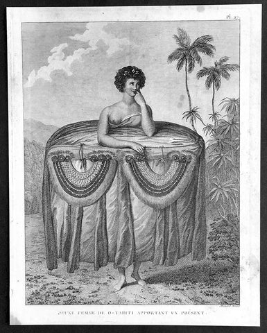
1785 Capt. Cook Visit to Tahiti in 1777 - Antique Print of Gifts for Cook & Men
- Title : Jeune Femme De O-Tahiti Apportant un Present
- Ref : 21348
- Size: 10in x 8in (255mm x 205mm)
- Date : 1785
- Condition: (A+) Fine Condition
Description:
This fine original copper-plate engraved antique print of a young Tahitian woman giving the ritual presentation of gifts of tapa cloth and two breast plates, along with food to Captain Cook and his crew, during a visit by Cook in 1777 during his 3rd and last Voyage of Discovery, was engraved by Robert Benard - after Cooks on-board artist, John Webber - and was published in the 1785 French edition of Capt. James Cook & Capt. James King A Voyage to the Pacific Ocean. Undertaken, by the Command of his Majesty, for making Discoveries in the Northern Hemisphere. To determine The Position and Extent of the West Side of North America; its Distance from Asia; and the Practicability of a Northen Passage to Europe. Performed under the direction of Captains Cook, Clerke, and Gore, In His Majesty\'s Ships the Resolution and Discovery. In the Years 1776, 1777, 1778, 1779, and 1780. In Three Volumes. Vol. I and II written by James Cook, F.R.S. Vol. III by Captain James King, LL.D. and F.R.S. Paris, 1785.
............Webber remarked on the ritual presentation of gifts of tapa cloth and two breast plates, along with food to Cook and his crew by two girls. The design of the girl’s attire recalls the wide panniers of eighteenth-century fashion, suggesting that the artist may have taken significant artistic license. However, the depiction is in concordance with Cook’s account. He describes seeing the girls dressed prior to their presentation, remarking on the “rather curious” manner in which one end of the cloth “was held up over the girls heads while the remainder was wraped round them under the armpits, then the upper ends were let fall and hung down in foulds to the ground over the other and looked something like a circular hooped petticoat. After ward round the out side of all were, were wraped several pieces of different Coloured cloth, which considerably increased the Size so that the whole was not less than five or six yards in circuit and was as much as the girls could support..............
General Definitions:
Paper thickness and quality: - Heavy and stable
Paper color : - off white
Age of map color: -
Colors used: -
General color appearance: -
Paper size: - 10in x 8in (255mm x 205mm)
Plate size: - 9 1/2in x 7 1/4in (240mm x 185mm)
Margins: - Min 1/2in (12mm)
Imperfections:
Margins: - Light soiling in margins
Plate area: - None
Verso: - None
Background:
Tahiti previously also known as Otaheite is the largest island in the Windward group of French Polynesia. The island is located in the archipelago of the Society Islands in the central Southern Pacific Ocean.
The first European to have visited Tahiti according to existing records was lieutenant Samuel Wallis, who was circumnavigating the globe in HMS Dolphin, sighting the island on 18 June 1767, and eventually harboring in Matavai Bay. This bay was situated on the territory of the chiefdom of Pare-Arue, governed by Tu (Tu-nui-e-a\\\\\\\'a-i-te-Atua) and his regent Tutaha, and the chiefdom of Ha apape, governed by Amo and his wife Oberea (Purea). Wallis named the island King Georges Island. The first contacts were difficult, since on the 24 and 26 June 1767, Tahitian warriors in canoes showed aggression towards the British, hurling stones from their slings. In retaliation, the British sailors opened fire on the warriors in the canoes and on the hills. In reaction to this powerful counter-attack, the Tahitians laid down peace offerings for the British. Following this episode, Samuel Wallis was able to establish cordial relations with the female chieftain “Oberea “ (Purea) and remained on the island until 27 July 1767.
In July 1768, Captain James Cook was commissioned by the Royal Society and on orders from the Lords Commissioners of the Admiralty to observe the transit of Venus across the sun, a phenomenon that would be visible from Tahiti on 3 June 1769. He arrived in Tahitis Matavai Bay, commanding the HMS Endeavour on 12 April 1769. On 14 April, Cook met with Tutaha and Tepau. On 15 April, Cook picked the site for a fortified camp at Point Venus along with Banks, Parkinson, Daniel Solander, to protect Charles Greens observatory. The length of stay enabled them to undertake for the first time real ethnographic and scientific observations of the island. Assisted by the botanist Joseph Banks, and by the artist Sydney Parkinson, Cook gathered valuable information on the fauna and flora, as well as the native society, language and customs, including the proper name of the island, Otaheite. On 28 April, Cook met Purea and Tupaia, and Tupaia befriended Banks following the transit. On 21 June, Amo visited Cook, and then on 25 June, Pohuetea visited, signifying another chief seeking to ally himself with the British.
Cook and Banks circumnavigated the island from 26 June to 1 July. On the exploration, they met Ahio, chief of Ha apaiano o or Papenoo, Rita, chief of Hitia a, Pahairro, chief of Pueu, Vehiatua, chief of Tautra, Matahiapo, chief of Teahupo o, Tutea, chief of Vaira o, and Moe, chief of Afa\\\\\\\'Ahiti. In Papara, guided by Tupaia, they investigated the ruins of Mahaiatea marae, an impressive structure containing a stone pyramid or ahu, measuring 44 feet high, 267 feet long and 87 feet wide. Cook and the Endeavour departed Tahiti on 13 July 1769, taking Raiatean navigator Tupaia along for his geographic knowledge of the islands.
Cook returned to Tahiti between 15 August and 1 September 1773, greeted by the chiefs Tai and Puhi, besides the youg ari i Vehiatua II and his stepfather Ti itorea. Cook anchored in Vaitepiha Bay before returning to Point Venus where he met Tu, the paramount chief. Cook picked up two passengers from Tahiti during this trip, Porea and Ma\\\\\\\'i, with Hitihiti later replacing Porea when Cook stopped at Raiatea. Cook took Hitihiti to Tahiti on 22 April, during his return leg. Then, Cook departed Tahiti on 14 May 1774.
During his final visit, Cook returned Mai to Tahiti on 12 Aug. 1777, after Mais long visit in England. Cook also brought two Maori from Queen Charlotte Sound, Te Weherua and Koa. Cook first harbored in Vaitepiha Bay, where he visited Vehiatua II s funeral bier and the prefabricated Spanish mission house. Cook also met Vehiatua III, and inscribed on the back of the Spanish cross, Georgius tertius Rex Annis 1767, 69, 73, 74 & 77, as a counterpoint to Christus Vincit Carolus III imperat 1774 on the front. On 23 Aug., Cook sailed for Matavai Bay, where he met Tu, his father Teu, his mother Tetupaia, his brothers Ari ipaea and Vaetua, and his sisters Ari ipaea-vahine, Tetua-te-ahamai, and Auo. Cook also observed a human sacrifice, taata tapu, at the Utu-ai-mahurau marae, and 49 skulls from previous victims.
On 29 Sept. 1777, Cook sailed for Papetoai Bay on Moorea. Cook met Mahine in an act of friendship on 3 Oct., though he was an enemy of Tu. When a goat kid was stolen on 6 Oct., Cook in a rampage, ordered the burning of houses and canoes until it was returned. Cook sailed for Huahine on 11 Oct., Raiatea on 2 Nov., and Borabora on 7 Dec.
On 26 October 1788, HMS Bounty, under the command of Captain William Bligh, landed in Tahiti with the mission of carrying Tahitian breadfruit trees (Tahitian: uru) to the Caribbean. Sir Joseph Banks, the botanist from James Cooks first expedition, had concluded that this plant would be ideal to feed the African slaves working in the Caribbean plantations at very little cost. The crew remained in Tahiti for about five months, the time needed to transplant the seedlings of the trees. Three weeks after leaving Tahiti, on 28 April 1789, the crew mutinied on the initiative of Fletcher Christian. The mutineers seized the ship and set the captain and most of those members of the crew who remained loyal to him adrift in a ship\\\\\\\'s boat. A group of mutineers then went back to settle in Tahiti.
Although various explorers had refused to get involved in tribal conflicts, the mutineers from the Bounty offered their services as mercenaries and furnished arms to the family which became the Pōmare Dynasty. The chief Tū knew how to use their presence in the harbours favoured by sailors to his advantage. As a result of his alliance with the mutineers, he succeeded in considerably increasing his supremacy over the island of Tahiti.
Captain James King FRS 1750 – 1784 was an officer of the Royal Navy. He served under James Cook on his last voyage around the world, specialising in taking important astronomical readings using a sextant. After Cook died he helped lead the ships on the remainder of their course, also completing Cook\\\'s account of the voyage. He continued his career in the Navy, reaching the rank of post-captain, commanding several ships and serving in the American War of Independence.
King joined HMS Resolution as second lieutenant, sharing the duties of astronomer with Cook, taking astronomical observations on board by sextant and with Larcum Kendals timekeeper K1, to establish the Resolutions position at sea and on shore by sextant or by astronomical quadrant to establish the geographical position of salient points during the course of Cooks surveys. Thus King\\\'s geographical positions were an important contribution to the accuracy of the various surveys carried out during the voyage and his use of the early chronometers helped prove their use at sea for calculation of Longitude. .
Following the death of Cook, King remained in the Resolution but on the death of Charles Clerke, Cooks successor, King was appointed to command HMS Discovery, the Resolution\\\'s consort, remaining in her for the rest of the voyage. After his return to England King was very much involved in the publication of the official account of Cooks third voyage, writing the third volume at Woodstock, near Oxford, where his brother Thomas was rector of St Mary Magdalene. But shortly after his return King was promoted Post-captain and appointed commander of HMS Crocodile in the English Channel.
John Webber RA 1751 – 1793 was an English artist who accompanied Captain Cook on his third Pacific expedition. He is best known for his images of Australasia, Hawaii and Alaska.
Webber was born in London, educated in Bern and studied painting at Paris.His father was Abraham Wäber, a Swiss sculptor who had moved to London, and changed his name to Webber before marrying a Mrs Mary Quant in 1744.
Webber served as official artist on James Cook\'s third voyage of discovery around the Pacific (1776–80) aboard HMS Resolution. At Adventure Bay in January 1777 he did drawings of A Man of Van Diemens Land and A Woman of Van Diemens Land. He also did many drawings of scenes in New Zealand and the South Sea islands. On this voyage, during which Cook lost his life in a fight in Hawaii, Webber became the first European artist to make contact with Hawaii, then called the Sandwich Islands. He made numerous watercolor landscapes of the islands of Kauai and Hawaii, and also portrayed many of the Hawaiian people.
In April 1778, Captain Cooks ships Resolution and Discovery anchored at Ship Cove, now known as Nootka Sound, Vancouver Island, Canada to refit. The crew took observations and recorded encounters with the local people. Webber made watercolour landscapes including Resolution and Discovery in Ship Cove, 1778. His drawings and paintings were engraved for British Admiraltys account of the expedition, which was published in 1784.
Back in England in 1780 Webber exhibited around 50 works at Royal Academy exhibitions between 1784 and 1792, and was elected an associate of the Royal Academy in 1785 and R.A. in 1791. Most of his work were landscapes. Sometimes figures were included as in A Party from H.M.S. Resolution shooting sea horses\", which was shown at the academy in 1784, and his The Death of Captain Cook became well known through an engraving of it. Another version of this picture is in the William Dixson gallery at Sydney
Robert Bénard 1734 – 1777 was an 18th-century French engraver.
Specialized in the technique of engraving, Robert Ménard is mainly famous for having supplied a significant amount of plates (at least 1,800) to the Encyclopédie by Diderot & d\'Alembert from 1751.
Later, publisher Charles-Joseph Panckoucke reused many of his productions to illustrate the works of his catalog.
1785 Capt. Cook Antique Print of a Possum from Bruny Island, Tasmania in 1777
- Title : Un Opossum De La Terre Van-Diemen
- Ref : 50608
- Size: 14in x 11 1/2in (355mm x 295mm)
- Date : 1784
- Condition: (A+) Fine Good Condition
Description:
This fine original copper-plate engraved antique print of a Possum of Adventure Bay on Bruny Island, Tasmania (Van Diemens Land) visited by Captain Cook during his 3rd & last Voyage of Discovery in 1777, was engraved by Robert Benard - after Cooks on-board artist, John Webber - and was published in the 1785 French edition of Capt. James Cook & Capt. James King A Voyage to the Pacific Ocean. Undertaken, by the Command of his Majesty, for making Discoveries in the Northern Hemisphere. To determine The Position and Extent of the West Side of North America; its Distance from Asia; and the Practicability of a Northen Passage to Europe. Performed under the direction of Captains Cook, Clerke, and Gore, In His Majesty\'s Ships the Resolution and Discovery. In the Years 1776, 1777, 1778, 1779, and 1780. In Three Volumes. Vol. I and II written by James Cook, F.R.S. Vol. III by Captain James King, LL.D. and F.R.S. Paris, 1785.
......This is the first printed image of an Australian possum made at Adventure Bay. Webber had completed a small group of bird drawings, and one of an opossum both of which had been shot and taken aboard..
General Definitions:
Paper thickness and quality: - Heavy and stable
Paper color : - off white
Age of map color: -
Colors used: -
General color appearance: -
Paper size: - 10in x 8in (255mm x 205mm)
Plate size: - 9 1/2in x 7 1/4in (240mm x 185mm)
Margins: - Min 1/2in (12mm)
Imperfections:
Margins: - None
Plate area: - None
Verso: - None
Background:
Adventure Bay is the name of both a township and a geographical feature on the eastern side of Bruny Island, Tasmania.
The first European to sight the bay was explorer Abel Tasman, who sought to anchor his vessel Heemskerck there in 1642. Instead, Heemskerck was driven back offshore by a storm, in token of which Tasman named the place Storm Bay. Captain Tobias Furneaux renamed it in March 1773, in honour of his ship HMS Adventure, which he had anchored in the bay for five days after becoming separated from Captain James Cook\'s HMS Resolution during Cook\'s second voyage to the Pacific search of Terra Australis Incognita. Furneaux\'s log made clear the bay was an excellent anchorage for resupplying vessels:....to the SW of the first watering place there is a large lagoon which I believe has plenty of fish in it for one of our Gentlemen caught upwards of 2 dozen trout, and shot a possum which was the only animal we saw. There are a great many gum trees and of a vast thickness and height, one of which measured in circumference 26 feet and the height under the branches was 20 feet.
Others among Furneaux\'s crew spotted evidence of what they believed were small deer but were more likely kangaroos. Furneaux also noted signs of an Aboriginal settlement in the form of several huts or wigwams on shore, with several bags of grass in which they carry their shellfish. - but the branches of which the huts were made were split and torn and there was not the least appearance of any people.
Reliably mapped and offering an abundance of water, fresh water and game, Adventure Bay quickly became a popular anchorage for European explorers. Cooks Resolution watered there in 1777, followed by William Bligh aboard HMS Bounty in 1788 and HMS Providence in 1792. Others who resupplied their vessels in the bay in this period included Bruni d Entrecasteaux aboard Recherché in 1792 and 1793, and Nicolas Baudin in the corvette Géographe in 1802. Matthew Flinders also tried to enter the bay with Norfolk in 1798.
Captain James King FRS 1750 – 1784 was an officer of the Royal Navy. He served under James Cook on his last voyage around the world, specialising in taking important astronomical readings using a sextant. After Cook died he helped lead the ships on the remainder of their course, also completing Cook\\\'s account of the voyage. He continued his career in the Navy, reaching the rank of post-captain, commanding several ships and serving in the American War of Independence.
King joined HMS Resolution as second lieutenant, sharing the duties of astronomer with Cook, taking astronomical observations on board by sextant and with Larcum Kendals timekeeper K1, to establish the Resolutions position at sea and on shore by sextant or by astronomical quadrant to establish the geographical position of salient points during the course of Cooks surveys. Thus King\\\'s geographical positions were an important contribution to the accuracy of the various surveys carried out during the voyage and his use of the early chronometers helped prove their use at sea for calculation of Longitude. .
Following the death of Cook, King remained in the Resolution but on the death of Charles Clerke, Cooks successor, King was appointed to command HMS Discovery, the Resolution\\\'s consort, remaining in her for the rest of the voyage. After his return to England King was very much involved in the publication of the official account of Cooks third voyage, writing the third volume at Woodstock, near Oxford, where his brother Thomas was rector of St Mary Magdalene. But shortly after his return King was promoted Post-captain and appointed commander of HMS Crocodile in the English Channel.
John Webber RA 1751 – 1793 was an English artist who accompanied Captain Cook on his third Pacific expedition. He is best known for his images of Australasia, Hawaii and Alaska.
Webber was born in London, educated in Bern and studied painting at Paris.His father was Abraham Wäber, a Swiss sculptor who had moved to London, and changed his name to Webber before marrying a Mrs Mary Quant in 1744.
Webber served as official artist on James Cook\'s third voyage of discovery around the Pacific (1776–80) aboard HMS Resolution. At Adventure Bay in January 1777 he did drawings of A Man of Van Diemens Land and A Woman of Van Diemens Land. He also did many drawings of scenes in New Zealand and the South Sea islands. On this voyage, during which Cook lost his life in a fight in Hawaii, Webber became the first European artist to make contact with Hawaii, then called the Sandwich Islands. He made numerous watercolor landscapes of the islands of Kauai and Hawaii, and also portrayed many of the Hawaiian people.
In April 1778, Captain Cooks ships Resolution and Discovery anchored at Ship Cove, now known as Nootka Sound, Vancouver Island, Canada to refit. The crew took observations and recorded encounters with the local people. Webber made watercolour landscapes including Resolution and Discovery in Ship Cove, 1778. His drawings and paintings were engraved for British Admiraltys account of the expedition, which was published in 1784.
Back in England in 1780 Webber exhibited around 50 works at Royal Academy exhibitions between 1784 and 1792, and was elected an associate of the Royal Academy in 1785 and R.A. in 1791. Most of his work were landscapes. Sometimes figures were included as in A Party from H.M.S. Resolution shooting sea horses\", which was shown at the academy in 1784, and his The Death of Captain Cook became well known through an engraving of it. Another version of this picture is in the William Dixson gallery at Sydney
Robert Bénard 1734 – 1777 was an 18th-century French engraver.
Specialized in the technique of engraving, Robert Ménard is mainly famous for having supplied a significant amount of plates (at least 1,800) to the Encyclopédie by Diderot & d\'Alembert from 1751.
Later, publisher Charles-Joseph Panckoucke reused many of his productions to illustrate the works of his catalog.
1773 Hawkesworth Antique Print Raiatea Island, French Polynesia - Capt Cook 1769
- Title : [A view in the island of Ulietea with a double canoe and a boathouse] ...E. Rooker sculp....No. 3
- Ref : 31816
- Size: 18 1/2in x 10 1/2in (470mm x 265mm)
- Date : 1773
- Condition: (A) Very Good Condition
Description:
This fine original copper-plate engraved antique print a view of fishing vessels, locals inspecting the days catch and views of the Island of Raiatea (Ulietea) in the Society Isles of French Polynesia, drawn by Sydney Parkinson, on Captain Cooks first visit to the Island in 1769, was engraved by Edward Rooker and published in the 1773 1st English edition of John Hawkesworths An account of the voyages undertaken by the order of His present Majesty for making discoveries in the Southern Hemisphere, and successively performed by Commodore Byron, Captain Wallis, Captain Carteret, and Captain Cook, in the Dolphin, the Swallow, and the Endeavor. Drawn up from the journals which were kept by the several commanders, and from the papers of Joseph Banks, Esq; by John Hawkesworth, LL.D. In three volumes. Illustrated with cuts, and a great variety of charts and maps relative to countries now first discovered, or hitherto but imperfectly known. London: printed for W. Strahan; and T. Cadell in the Strand, MDCCLXXIII.
..........a double canoe (pahi) with carved figures on bow and stern. Another double canoe in the background at right and a boathouse at left. There are a great number of boathouses all round the bays built with a Catanarian arch, thatched all over; and the boats kept in them are very long, bellying out on the sides, with a very high peak stern, and are used only at particular seasons.....from the account by Sydney Parkinson 1769
General Definitions:
Paper thickness and quality: - Heavy and stable
Paper color : - off white
Age of map color: -
Colors used: -
General color appearance: -
Paper size: - 18 1/2in x 10 1/2in (470mm x 265mm)
Plate size: - 18 1/2in x 9 1/2in (470mm x 240mm)
Margins: - Min 1/2in (12mm)
Imperfections:
Margins: - Folds as issued
Plate area: - Folds as issued, creasing and light soiling along folds
Verso: - Folds as issued
Background:
Raiatea, is the second largest of the Society Islands, after Tahiti, in French Polynesia. The island is widely regarded as the centre of the eastern islands in ancient Polynesia and it is likely that the organised migrations to Hawaii, Aotearoa and other parts of East Polynesia started at Raiātea.
A traditional name for the island is Havaii, homeland of the Māori people.
The first European to record sighting Ra iātea was Pedro Fernandes de Queirós in 1606; it was charted as La Fugitiva The Polynesian navigator, Tupaia, who sailed with explorer James Cook, was born in Raiātea around 1725.
Cook visited Raiatea in 1769 and again in 1773-1774. Omai (c.1751-1780), another young man from Raiātea, traveled with the European explorers to London in 1774 and also served as an interpreter to Captain Cook on his second and third journey.
King Tamatoa VI was the last monarch, reigning from 1884-1888.
Sydney Parkinson 1745 – 71 was draughtsman to the botanist Sir Joseph Banks on James Cook’s first voyage to the Pacific in 1768. He died of dysentery in 1771, on the homeward voyage.
Parkinson was the first European artist to create drawings of Indigenous Australian, Maori & South Sea peoples, as well as landscapes, from direct observation. Hundreds of his original drawings survive in the British Museum. He is particularly remembered for his plant illustrations which were later used to create the lavish plates for Joseph Banks’ Florilegium.
When the Endeavour returned to England in 1772, a dispute arose between Joseph Banks and Sydney’s brother, Stanfield Parkinson. As his employer, Banks claimed rights to Sydney’s drawings, papers and collections made on the voyage. Stanfield claimed that Sydney had willed them to his family. Banks lent the Parkinson family Sydney’s journal and drawings with instructions that they were not to be published, however Stanfield disregarded this and arranged for A Journal of a voyage to the South Seas to be printed from Sydney’s account of the voyage.
Banks managed to suppress Stanfield’s publication until the official account of the voyage, edited by John Hawkesworth, appeared. In return for Parkinson’s papers, Banks paid Stanfield Parkinson 500 pounds for balance of wages due to Sydney, but the dispute did not end there. Stanfield further accused Banks of retaining items collected by Sydney which were intended for his relatives. Stanfield Parkinson was declared insane soon after the publication of Sydney Parkinson’s Journal and died in an asylum.
John Hawkesworth an English writer and journalist, Hawkesworth was commissioned by the British Admiralty to edit for publication the narratives of its officers’ circumnavigations. He was given full access to the journals of the commanders and the freedom to adapt and re-tell them in the first person. Cook was already on his way back from his second Pacific voyage, temporarily docked at Cape Town (South Africa), when he first saw the published volumes: he was mortified and furious to find that Hawkesworth claimed in the introduction that Cook had seen and blessed (with slight corrections) the resulting manuscript. (In his defense, Hawkesworth also had been a victim of misunderstanding.) Cook had trouble recognizing himself. Moreover, the work was full of errors and commentary introduced by Hawkesworth and, in Cook’s view, too full of Banks, who had promoted himself and the publication. Still, the work was popular; the first edition sold out in several months.
Edward Rooker 1712 – 1774 was an English engraver, draughtsman and actor.
1784 Anderson Antique Print of King Pomare I of Tahiti w/ Captain Cook on the Resolution 1773
- Title : A Chief and other Natives of O Taheitee visiting Captain Cook in his second Voyage to the Southern Hemisphere
- Date : 1784
- Ref # : 21618
- Size : 13 1/2in x 9 1/2in (345mm x 240mm)
- Condition: (A+) Fine Condition
Description:
This fine original copper-plate engraved antique print of Captain James Cook meeting Pomare I & other Tahitian dignitaries on HMS Resolution, during his second Voyage of Discovery to the South Seas in 1773 & 1774, was published in George Andersons 1784 edition of A Collection of voyages round the world : performed by royal authority : containing a complete historical account of Captain Cooks first, second, third and last voyages, undertaken for making new discoveries, &c. ... published by Alexander Hogg, London 1784.
Among the Tahitian dignitaries were chiefs whom Cook had met during his 1st voyage and others that had come to power during his absence.
Cook was warmly greeted by the chiefs Tai and Puhi, besides the youg ari i Vehiatua II and his stepfather Ti itorea. Cook anchored in Vaitepiha Bay before returning to Point Venus where he met Tu (Pomare I) the paramount chief.
Cook picked up two passengers from Tahiti during this trip, Porea and Mai, with Hitihiti later replacing Porea when Cook stopped at Raiatea. Cook took Hitihiti to Tahiti on 22 April, during his return leg. Cook departed Tahiti on 14 May 1774.
Pomare I 1753 – 1803 (fully in old orthography: Tu-nui-ea-i-te-atua-i-Tarahoi Vaira atoa Taina Pomare I; also known as Tu or Tinah or Outu, or more formally as Tu-nui-a a-i-te-atua), was the unifier and first king of Tahiti and founder of the Pomare dynasty and the Kingdom of Tahiti between 1788 and 1791. He abdicated in 1791, but remained in power as the guardian regent during the minority of his successor Pomare II from 1791 until 1803.
Pomare I was born at Pare, and was the second son of Teu Tunuieaiteatua by his wife, Tetupaia-i-Hauiri. He initially reigned under the regency of his father. He succeeded on the death of his father as Ari i-rahi of Porionu u 23 November 1802.
Pomare was the Tahitian chieftain most friendly to the British. The additional British captains arriving at Tahiti accepted his claim to hegemony. They gave him guns in trade and helped him in his battles. Captain Cook gave him the advantage in a number of battles with rival forces during his last stay in Tahiti. British missionaries arrived, sent by a non-denominational Protestant group called the London Missionary Society. Pomare befriended the missionaries, and the missionaries favored both peace and Pomare, but, with the British unwilling to apply force to create order among the islands, the missionaries were unable to stop the warring.
General Definitions:
Paper thickness and quality: - Heavy and stable
Paper color : - off white
Age of map color: -
Colors used: -
General color appearance: -
Paper size: - 13 1/2in x 9 1/2in (345mm x 240mm)
Plate size: - 13 1/2in x 9 1/2in (345mm x 240mm)
Margins: - Min 1/2in (12mm)
Imperfections:
Margins: - Age toning
Plate area: - Age toning
Verso: - Age toning
Background:
Cooks Second Voyage (1772–75) Shortly after his return from the first voyage, Cook was promoted in August 1771, to the rank of commander. In 1772 he was commissioned to lead another scientific expedition on behalf of the Royal Society, to search for the hypothetical Terra Australis. On his first voyage, Cook had demonstrated by circumnavigating New Zealand that it was not attached to a larger landmass to the south. Although he charted almost the entire eastern coastline of Australia, showing it to be continental in size, the Terra Australis was believed to lie further south. Despite this evidence to the contrary, Alexander Dalrymple and others of the Royal Society still believed that a massive southern continent should exist.
Cook commanded HMS Resolution on this voyage, while Tobias Furneaux commanded its companion ship, HMS Adventure. Cook\\\'s expedition circumnavigated the globe at an extreme southern latitude, becoming one of the first to cross the Antarctic Circle (17 January 1773). In the Antarctic fog, Resolution and Adventure became separated. Furneaux made his way to New Zealand, where he lost some of his men during an encounter with Māori, and eventually sailed back to Britain, while Cook continued to explore the Antarctic, reaching 71°10\\\'S on 31 January 1774.
Cook almost encountered the mainland of Antarctica, but turned towards Tahiti to resupply his ship. He then resumed his southward course in a second fruitless attempt to find the supposed continent. On this leg of the voyage he brought a young Tahitian named Omai, who proved to be somewhat less knowledgeable about the Pacific than Tupaia had been on the first voyage. On his return voyage to New Zealand in 1774, Cook landed at the Friendly Islands, Easter Island, Norfolk Island, New Caledonia, and Vanuatu.
Before returning to England, Cook made a final sweep across the South Atlantic from Cape Horn and surveyed, mapped and took possession for Britain of South Georgia, which had been explored by Anthony de la Roché in 1675. Cook also discovered and named Clerke Rocks and the South Sandwich Islands (\\\"Sandwich Land\\\"). He then turned north to South Africa, and from there continued back to England. His reports upon his return home put to rest the popular myth of Terra Australis.
Cook\\\'s second voyage marked a successful employment of Larcum Kendall\\\'s K1 copy of John Harrison\\\'s H4 marine chronometer, which enabled Cook to calculate his longitudinal position with much greater accuracy. Cook\\\'s log was full of praise for this time-piece which he used to make charts of the southern Pacific Ocean that were so remarkably accurate that copies of them were still in use in the mid-20th century.
Upon his return, Cook was promoted to the rank of post-captain and given an honorary retirement from the Royal Navy, with a posting as an officer of the Greenwich Hospital. He reluctantly accepted, insisting that he be allowed to quit the post if an opportunity for active duty should arise. His fame extended beyond the Admiralty; he was made a Fellow of the Royal Society, and awarded the Copley Gold Medal for completing his second voyage without losing a man to scurvy. Nathaniel Dance-Holland painted his portrait; he dined with James Boswell; he was described in the House of Lords as \\\"the first navigator in Europe\\\". But he could not be kept away from the sea. A third voyage was planned and Cook volunteered to find the Northwest Passage. He travelled to the Pacific and hoped to travel east to the Atlantic, while a simultaneous voyage travelled the opposite route.
Tahiti previously also known as Otaheite is the largest island in the Windward group of French Polynesia. The island is located in the archipelago of the Society Islands in the central Southern Pacific Ocean.
The first European to have visited Tahiti according to existing records was lieutenant Samuel Wallis, who was circumnavigating the globe in HMS Dolphin, sighting the island on 18 June 1767, and eventually harboring in Matavai Bay. This bay was situated on the territory of the chiefdom of Pare-Arue, governed by Tu (Tu-nui-e-a\\\\\\\'a-i-te-Atua) and his regent Tutaha, and the chiefdom of Ha apape, governed by Amo and his wife Oberea (Purea). Wallis named the island King Georges Island. The first contacts were difficult, since on the 24 and 26 June 1767, Tahitian warriors in canoes showed aggression towards the British, hurling stones from their slings. In retaliation, the British sailors opened fire on the warriors in the canoes and on the hills. In reaction to this powerful counter-attack, the Tahitians laid down peace offerings for the British. Following this episode, Samuel Wallis was able to establish cordial relations with the female chieftain “Oberea “ (Purea) and remained on the island until 27 July 1767.
In July 1768, Captain James Cook was commissioned by the Royal Society and on orders from the Lords Commissioners of the Admiralty to observe the transit of Venus across the sun, a phenomenon that would be visible from Tahiti on 3 June 1769. He arrived in Tahitis Matavai Bay, commanding the HMS Endeavour on 12 April 1769. On 14 April, Cook met with Tutaha and Tepau. On 15 April, Cook picked the site for a fortified camp at Point Venus along with Banks, Parkinson, Daniel Solander, to protect Charles Greens observatory. The length of stay enabled them to undertake for the first time real ethnographic and scientific observations of the island. Assisted by the botanist Joseph Banks, and by the artist Sydney Parkinson, Cook gathered valuable information on the fauna and flora, as well as the native society, language and customs, including the proper name of the island, Otaheite. On 28 April, Cook met Purea and Tupaia, and Tupaia befriended Banks following the transit. On 21 June, Amo visited Cook, and then on 25 June, Pohuetea visited, signifying another chief seeking to ally himself with the British.
Cook and Banks circumnavigated the island from 26 June to 1 July. On the exploration, they met Ahio, chief of Ha apaiano o or Papenoo, Rita, chief of Hitia a, Pahairro, chief of Pueu, Vehiatua, chief of Tautra, Matahiapo, chief of Teahupo o, Tutea, chief of Vaira o, and Moe, chief of Afa\\\\\\\'Ahiti. In Papara, guided by Tupaia, they investigated the ruins of Mahaiatea marae, an impressive structure containing a stone pyramid or ahu, measuring 44 feet high, 267 feet long and 87 feet wide. Cook and the Endeavour departed Tahiti on 13 July 1769, taking Raiatean navigator Tupaia along for his geographic knowledge of the islands.
Cook returned to Tahiti between 15 August and 1 September 1773, greeted by the chiefs Tai and Puhi, besides the youg ari i Vehiatua II and his stepfather Ti itorea. Cook anchored in Vaitepiha Bay before returning to Point Venus where he met Tu, the paramount chief. Cook picked up two passengers from Tahiti during this trip, Porea and Ma\\\\\\\'i, with Hitihiti later replacing Porea when Cook stopped at Raiatea. Cook took Hitihiti to Tahiti on 22 April, during his return leg. Then, Cook departed Tahiti on 14 May 1774.
During his final visit, Cook returned Mai to Tahiti on 12 Aug. 1777, after Mais long visit in England. Cook also brought two Maori from Queen Charlotte Sound, Te Weherua and Koa. Cook first harbored in Vaitepiha Bay, where he visited Vehiatua II s funeral bier and the prefabricated Spanish mission house. Cook also met Vehiatua III, and inscribed on the back of the Spanish cross, Georgius tertius Rex Annis 1767, 69, 73, 74 & 77, as a counterpoint to Christus Vincit Carolus III imperat 1774 on the front. On 23 Aug., Cook sailed for Matavai Bay, where he met Tu, his father Teu, his mother Tetupaia, his brothers Ari ipaea and Vaetua, and his sisters Ari ipaea-vahine, Tetua-te-ahamai, and Auo. Cook also observed a human sacrifice, taata tapu, at the Utu-ai-mahurau marae, and 49 skulls from previous victims.
On 29 Sept. 1777, Cook sailed for Papetoai Bay on Moorea. Cook met Mahine in an act of friendship on 3 Oct., though he was an enemy of Tu. When a goat kid was stolen on 6 Oct., Cook in a rampage, ordered the burning of houses and canoes until it was returned. Cook sailed for Huahine on 11 Oct., Raiatea on 2 Nov., and Borabora on 7 Dec.
On 26 October 1788, HMS Bounty, under the command of Captain William Bligh, landed in Tahiti with the mission of carrying Tahitian breadfruit trees (Tahitian: uru) to the Caribbean. Sir Joseph Banks, the botanist from James Cooks first expedition, had concluded that this plant would be ideal to feed the African slaves working in the Caribbean plantations at very little cost. The crew remained in Tahiti for about five months, the time needed to transplant the seedlings of the trees. Three weeks after leaving Tahiti, on 28 April 1789, the crew mutinied on the initiative of Fletcher Christian. The mutineers seized the ship and set the captain and most of those members of the crew who remained loyal to him adrift in a ship\\\\\\\'s boat. A group of mutineers then went back to settle in Tahiti.
Although various explorers had refused to get involved in tribal conflicts, the mutineers from the Bounty offered their services as mercenaries and furnished arms to the family which became the Pōmare Dynasty. The chief Tū knew how to use their presence in the harbours favoured by sailors to his advantage. As a result of his alliance with the mutineers, he succeeded in considerably increasing his supremacy over the island of Tahiti.
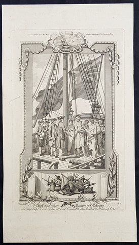
1784 Anderson Antique Print of King Pomare I of Tahiti w/ Captain Cook on the Resolution 1773
- Title : A Chief and other Natives of O Taheitee visiting Captain Cook in his second Voyage to the Southern Hemisphere
- Date : 1784
- Ref # : 21667
- Size : 13 1/2in x 9 1/2in (345mm x 240mm)
- Condition: (A+) Fine Condition
Description:
This fine original copper-plate engraved antique print of Captain James Cook meeting Pomare I & other Tahitian dignitaries on HMS Resolution, during his second Voyage of Discovery to the South Seas in 1773 & 1774, was published in George Andersons 1784 edition of A Collection of voyages round the world : performed by royal authority : containing a complete historical account of Captain Cooks first, second, third and last voyages, undertaken for making new discoveries, &c. ... published by Alexander Hogg, London 1784.
Among the Tahitian dignitaries were chiefs whom Cook had met during his 1st voyage and others that had come to power during his absence.
Cook was warmly greeted by the chiefs Tai and Puhi, besides the youg ari i Vehiatua II and his stepfather Ti itorea. Cook anchored in Vaitepiha Bay before returning to Point Venus where he met Tu (Pomare I) the paramount chief.
Cook picked up two passengers from Tahiti during this trip, Porea and Mai, with Hitihiti later replacing Porea when Cook stopped at Raiatea. Cook took Hitihiti to Tahiti on 22 April, during his return leg. Cook departed Tahiti on 14 May 1774.
Pomare I 1753 – 1803 (fully in old orthography: Tu-nui-ea-i-te-atua-i-Tarahoi Vaira atoa Taina Pomare I; also known as Tu or Tinah or Outu, or more formally as Tu-nui-a a-i-te-atua), was the unifier and first king of Tahiti and founder of the Pomare dynasty and the Kingdom of Tahiti between 1788 and 1791. He abdicated in 1791, but remained in power as the guardian regent during the minority of his successor Pomare II from 1791 until 1803.
Pomare I was born at Pare, and was the second son of Teu Tunuieaiteatua by his wife, Tetupaia-i-Hauiri. He initially reigned under the regency of his father. He succeeded on the death of his father as Ari i-rahi of Porionu u 23 November 1802.
Pomare was the Tahitian chieftain most friendly to the British. The additional British captains arriving at Tahiti accepted his claim to hegemony. They gave him guns in trade and helped him in his battles. Captain Cook gave him the advantage in a number of battles with rival forces during his last stay in Tahiti. British missionaries arrived, sent by a non-denominational Protestant group called the London Missionary Society. Pomare befriended the missionaries, and the missionaries favored both peace and Pomare, but, with the British unwilling to apply force to create order among the islands, the missionaries were unable to stop the warring.
General Definitions:
Paper thickness and quality: - Heavy and stable
Paper color : - off white
Age of map color: -
Colors used: -
General color appearance: -
Paper size: - 13 1/2in x 9 1/2in (345mm x 240mm)
Plate size: - 13 1/2in x 9 1/2in (345mm x 240mm)
Margins: - Min 1/2in (12mm)
Imperfections:
Margins: - Age toning
Plate area: - Age toning
Verso: - Age toning
Background:
Cooks Second Voyage (1772–75) Shortly after his return from the first voyage, Cook was promoted in August 1771, to the rank of commander. In 1772 he was commissioned to lead another scientific expedition on behalf of the Royal Society, to search for the hypothetical Terra Australis. On his first voyage, Cook had demonstrated by circumnavigating New Zealand that it was not attached to a larger landmass to the south. Although he charted almost the entire eastern coastline of Australia, showing it to be continental in size, the Terra Australis was believed to lie further south. Despite this evidence to the contrary, Alexander Dalrymple and others of the Royal Society still believed that a massive southern continent should exist.
Cook commanded HMS Resolution on this voyage, while Tobias Furneaux commanded its companion ship, HMS Adventure. Cook\\\'s expedition circumnavigated the globe at an extreme southern latitude, becoming one of the first to cross the Antarctic Circle (17 January 1773). In the Antarctic fog, Resolution and Adventure became separated. Furneaux made his way to New Zealand, where he lost some of his men during an encounter with Māori, and eventually sailed back to Britain, while Cook continued to explore the Antarctic, reaching 71°10\\\'S on 31 January 1774.
Cook almost encountered the mainland of Antarctica, but turned towards Tahiti to resupply his ship. He then resumed his southward course in a second fruitless attempt to find the supposed continent. On this leg of the voyage he brought a young Tahitian named Omai, who proved to be somewhat less knowledgeable about the Pacific than Tupaia had been on the first voyage. On his return voyage to New Zealand in 1774, Cook landed at the Friendly Islands, Easter Island, Norfolk Island, New Caledonia, and Vanuatu.
Before returning to England, Cook made a final sweep across the South Atlantic from Cape Horn and surveyed, mapped and took possession for Britain of South Georgia, which had been explored by Anthony de la Roché in 1675. Cook also discovered and named Clerke Rocks and the South Sandwich Islands (\\\"Sandwich Land\\\"). He then turned north to South Africa, and from there continued back to England. His reports upon his return home put to rest the popular myth of Terra Australis.
Cook\\\'s second voyage marked a successful employment of Larcum Kendall\\\'s K1 copy of John Harrison\\\'s H4 marine chronometer, which enabled Cook to calculate his longitudinal position with much greater accuracy. Cook\\\'s log was full of praise for this time-piece which he used to make charts of the southern Pacific Ocean that were so remarkably accurate that copies of them were still in use in the mid-20th century.
Upon his return, Cook was promoted to the rank of post-captain and given an honorary retirement from the Royal Navy, with a posting as an officer of the Greenwich Hospital. He reluctantly accepted, insisting that he be allowed to quit the post if an opportunity for active duty should arise. His fame extended beyond the Admiralty; he was made a Fellow of the Royal Society, and awarded the Copley Gold Medal for completing his second voyage without losing a man to scurvy. Nathaniel Dance-Holland painted his portrait; he dined with James Boswell; he was described in the House of Lords as \\\"the first navigator in Europe\\\". But he could not be kept away from the sea. A third voyage was planned and Cook volunteered to find the Northwest Passage. He travelled to the Pacific and hoped to travel east to the Atlantic, while a simultaneous voyage travelled the opposite route.
Tahiti previously also known as Otaheite is the largest island in the Windward group of French Polynesia. The island is located in the archipelago of the Society Islands in the central Southern Pacific Ocean.
The first European to have visited Tahiti according to existing records was lieutenant Samuel Wallis, who was circumnavigating the globe in HMS Dolphin, sighting the island on 18 June 1767, and eventually harboring in Matavai Bay. This bay was situated on the territory of the chiefdom of Pare-Arue, governed by Tu (Tu-nui-e-a\\\\\\\'a-i-te-Atua) and his regent Tutaha, and the chiefdom of Ha apape, governed by Amo and his wife Oberea (Purea). Wallis named the island King Georges Island. The first contacts were difficult, since on the 24 and 26 June 1767, Tahitian warriors in canoes showed aggression towards the British, hurling stones from their slings. In retaliation, the British sailors opened fire on the warriors in the canoes and on the hills. In reaction to this powerful counter-attack, the Tahitians laid down peace offerings for the British. Following this episode, Samuel Wallis was able to establish cordial relations with the female chieftain “Oberea “ (Purea) and remained on the island until 27 July 1767.
In July 1768, Captain James Cook was commissioned by the Royal Society and on orders from the Lords Commissioners of the Admiralty to observe the transit of Venus across the sun, a phenomenon that would be visible from Tahiti on 3 June 1769. He arrived in Tahitis Matavai Bay, commanding the HMS Endeavour on 12 April 1769. On 14 April, Cook met with Tutaha and Tepau. On 15 April, Cook picked the site for a fortified camp at Point Venus along with Banks, Parkinson, Daniel Solander, to protect Charles Greens observatory. The length of stay enabled them to undertake for the first time real ethnographic and scientific observations of the island. Assisted by the botanist Joseph Banks, and by the artist Sydney Parkinson, Cook gathered valuable information on the fauna and flora, as well as the native society, language and customs, including the proper name of the island, Otaheite. On 28 April, Cook met Purea and Tupaia, and Tupaia befriended Banks following the transit. On 21 June, Amo visited Cook, and then on 25 June, Pohuetea visited, signifying another chief seeking to ally himself with the British.
Cook and Banks circumnavigated the island from 26 June to 1 July. On the exploration, they met Ahio, chief of Ha apaiano o or Papenoo, Rita, chief of Hitia a, Pahairro, chief of Pueu, Vehiatua, chief of Tautra, Matahiapo, chief of Teahupo o, Tutea, chief of Vaira o, and Moe, chief of Afa\\\\\\\'Ahiti. In Papara, guided by Tupaia, they investigated the ruins of Mahaiatea marae, an impressive structure containing a stone pyramid or ahu, measuring 44 feet high, 267 feet long and 87 feet wide. Cook and the Endeavour departed Tahiti on 13 July 1769, taking Raiatean navigator Tupaia along for his geographic knowledge of the islands.
Cook returned to Tahiti between 15 August and 1 September 1773, greeted by the chiefs Tai and Puhi, besides the youg ari i Vehiatua II and his stepfather Ti itorea. Cook anchored in Vaitepiha Bay before returning to Point Venus where he met Tu, the paramount chief. Cook picked up two passengers from Tahiti during this trip, Porea and Ma\\\\\\\'i, with Hitihiti later replacing Porea when Cook stopped at Raiatea. Cook took Hitihiti to Tahiti on 22 April, during his return leg. Then, Cook departed Tahiti on 14 May 1774.
During his final visit, Cook returned Mai to Tahiti on 12 Aug. 1777, after Mais long visit in England. Cook also brought two Maori from Queen Charlotte Sound, Te Weherua and Koa. Cook first harbored in Vaitepiha Bay, where he visited Vehiatua II s funeral bier and the prefabricated Spanish mission house. Cook also met Vehiatua III, and inscribed on the back of the Spanish cross, Georgius tertius Rex Annis 1767, 69, 73, 74 & 77, as a counterpoint to Christus Vincit Carolus III imperat 1774 on the front. On 23 Aug., Cook sailed for Matavai Bay, where he met Tu, his father Teu, his mother Tetupaia, his brothers Ari ipaea and Vaetua, and his sisters Ari ipaea-vahine, Tetua-te-ahamai, and Auo. Cook also observed a human sacrifice, taata tapu, at the Utu-ai-mahurau marae, and 49 skulls from previous victims.
On 29 Sept. 1777, Cook sailed for Papetoai Bay on Moorea. Cook met Mahine in an act of friendship on 3 Oct., though he was an enemy of Tu. When a goat kid was stolen on 6 Oct., Cook in a rampage, ordered the burning of houses and canoes until it was returned. Cook sailed for Huahine on 11 Oct., Raiatea on 2 Nov., and Borabora on 7 Dec.
On 26 October 1788, HMS Bounty, under the command of Captain William Bligh, landed in Tahiti with the mission of carrying Tahitian breadfruit trees (Tahitian: uru) to the Caribbean. Sir Joseph Banks, the botanist from James Cooks first expedition, had concluded that this plant would be ideal to feed the African slaves working in the Caribbean plantations at very little cost. The crew remained in Tahiti for about five months, the time needed to transplant the seedlings of the trees. Three weeks after leaving Tahiti, on 28 April 1789, the crew mutinied on the initiative of Fletcher Christian. The mutineers seized the ship and set the captain and most of those members of the crew who remained loyal to him adrift in a ship\\\\\\\'s boat. A group of mutineers then went back to settle in Tahiti.
Although various explorers had refused to get involved in tribal conflicts, the mutineers from the Bounty offered their services as mercenaries and furnished arms to the family which became the Pōmare Dynasty. The chief Tū knew how to use their presence in the harbours favoured by sailors to his advantage. As a result of his alliance with the mutineers, he succeeded in considerably increasing his supremacy over the island of Tahiti.
1784 Anderson Antique Print of King Pomare I of Tahiti w/ Captain Cook on the Resolution 1773
- Title : A Chief and other Natives of O Taheitee visiting Captain Cook in his second Voyage to the Southern Hemisphere
- Date : 1784
- Ref # : 21507
- Size : 13 1/2in x 9 1/2in (345mm x 240mm)
- Condition: (A) Very Good Condition
Description:
This fine original copper-plate engraved antique print of Captain James Cook meeting Pomare I & other Tahitian dignitaries on HMS Resolution, during his second Voyage of Discovery to the South Seas in 1773 & 1774, was published in George Andersons 1784 edition of A Collection of voyages round the world : performed by royal authority : containing a complete historical account of Captain Cooks first, second, third and last voyages, undertaken for making new discoveries, &c. ... published by Alexander Hogg, London 1784.
Among the Tahitian dignitaries were chiefs whom Cook had met during his 1st voyage and others that had come to power during his absence.
Cook was warmly greeted by the chiefs Tai and Puhi, besides the youg ari i Vehiatua II and his stepfather Ti itorea. Cook anchored in Vaitepiha Bay before returning to Point Venus where he met Tu (Pomare I) the paramount chief.
Cook picked up two passengers from Tahiti during this trip, Porea and Mai, with Hitihiti later replacing Porea when Cook stopped at Raiatea. Cook took Hitihiti to Tahiti on 22 April, during his return leg. Cook departed Tahiti on 14 May 1774.
Pomare I 1753 – 1803 (fully in old orthography: Tu-nui-ea-i-te-atua-i-Tarahoi Vaira atoa Taina Pomare I; also known as Tu or Tinah or Outu, or more formally as Tu-nui-a a-i-te-atua), was the unifier and first king of Tahiti and founder of the Pomare dynasty and the Kingdom of Tahiti between 1788 and 1791. He abdicated in 1791, but remained in power as the guardian regent during the minority of his successor Pomare II from 1791 until 1803.
Pomare I was born at Pare, and was the second son of Teu Tunuieaiteatua by his wife, Tetupaia-i-Hauiri. He initially reigned under the regency of his father. He succeeded on the death of his father as Ari i-rahi of Porionu u 23 November 1802.
Pomare was the Tahitian chieftain most friendly to the British. The additional British captains arriving at Tahiti accepted his claim to hegemony. They gave him guns in trade and helped him in his battles. Captain Cook gave him the advantage in a number of battles with rival forces during his last stay in Tahiti. British missionaries arrived, sent by a non-denominational Protestant group called the London Missionary Society. Pomare befriended the missionaries, and the missionaries favored both peace and Pomare, but, with the British unwilling to apply force to create order among the islands, the missionaries were unable to stop the warring.
General Definitions:
Paper thickness and quality: - Heavy and stable
Paper color : - off white
Age of map color: -
Colors used: -
General color appearance: -
Paper size: - 13 1/2in x 9 1/2in (345mm x 240mm)
Plate size: - 13 1/2in x 9 1/2in (345mm x 240mm)
Margins: - Min 1/2in (12mm)
Imperfections:
Margins: - Age toning
Plate area: - Age toning
Verso: - Age toning
Background:
Cooks Second Voyage (1772–75) Shortly after his return from the first voyage, Cook was promoted in August 1771, to the rank of commander. In 1772 he was commissioned to lead another scientific expedition on behalf of the Royal Society, to search for the hypothetical Terra Australis. On his first voyage, Cook had demonstrated by circumnavigating New Zealand that it was not attached to a larger landmass to the south. Although he charted almost the entire eastern coastline of Australia, showing it to be continental in size, the Terra Australis was believed to lie further south. Despite this evidence to the contrary, Alexander Dalrymple and others of the Royal Society still believed that a massive southern continent should exist.
Cook commanded HMS Resolution on this voyage, while Tobias Furneaux commanded its companion ship, HMS Adventure. Cook\\\'s expedition circumnavigated the globe at an extreme southern latitude, becoming one of the first to cross the Antarctic Circle (17 January 1773). In the Antarctic fog, Resolution and Adventure became separated. Furneaux made his way to New Zealand, where he lost some of his men during an encounter with Māori, and eventually sailed back to Britain, while Cook continued to explore the Antarctic, reaching 71°10\\\'S on 31 January 1774.
Cook almost encountered the mainland of Antarctica, but turned towards Tahiti to resupply his ship. He then resumed his southward course in a second fruitless attempt to find the supposed continent. On this leg of the voyage he brought a young Tahitian named Omai, who proved to be somewhat less knowledgeable about the Pacific than Tupaia had been on the first voyage. On his return voyage to New Zealand in 1774, Cook landed at the Friendly Islands, Easter Island, Norfolk Island, New Caledonia, and Vanuatu.
Before returning to England, Cook made a final sweep across the South Atlantic from Cape Horn and surveyed, mapped and took possession for Britain of South Georgia, which had been explored by Anthony de la Roché in 1675. Cook also discovered and named Clerke Rocks and the South Sandwich Islands (\\\"Sandwich Land\\\"). He then turned north to South Africa, and from there continued back to England. His reports upon his return home put to rest the popular myth of Terra Australis.
Cook\\\'s second voyage marked a successful employment of Larcum Kendall\\\'s K1 copy of John Harrison\\\'s H4 marine chronometer, which enabled Cook to calculate his longitudinal position with much greater accuracy. Cook\\\'s log was full of praise for this time-piece which he used to make charts of the southern Pacific Ocean that were so remarkably accurate that copies of them were still in use in the mid-20th century.
Upon his return, Cook was promoted to the rank of post-captain and given an honorary retirement from the Royal Navy, with a posting as an officer of the Greenwich Hospital. He reluctantly accepted, insisting that he be allowed to quit the post if an opportunity for active duty should arise. His fame extended beyond the Admiralty; he was made a Fellow of the Royal Society, and awarded the Copley Gold Medal for completing his second voyage without losing a man to scurvy. Nathaniel Dance-Holland painted his portrait; he dined with James Boswell; he was described in the House of Lords as \\\"the first navigator in Europe\\\". But he could not be kept away from the sea. A third voyage was planned and Cook volunteered to find the Northwest Passage. He travelled to the Pacific and hoped to travel east to the Atlantic, while a simultaneous voyage travelled the opposite route.
Tahiti previously also known as Otaheite is the largest island in the Windward group of French Polynesia. The island is located in the archipelago of the Society Islands in the central Southern Pacific Ocean.
The first European to have visited Tahiti according to existing records was lieutenant Samuel Wallis, who was circumnavigating the globe in HMS Dolphin, sighting the island on 18 June 1767, and eventually harboring in Matavai Bay. This bay was situated on the territory of the chiefdom of Pare-Arue, governed by Tu (Tu-nui-e-a\\\\\\\'a-i-te-Atua) and his regent Tutaha, and the chiefdom of Ha apape, governed by Amo and his wife Oberea (Purea). Wallis named the island King Georges Island. The first contacts were difficult, since on the 24 and 26 June 1767, Tahitian warriors in canoes showed aggression towards the British, hurling stones from their slings. In retaliation, the British sailors opened fire on the warriors in the canoes and on the hills. In reaction to this powerful counter-attack, the Tahitians laid down peace offerings for the British. Following this episode, Samuel Wallis was able to establish cordial relations with the female chieftain “Oberea “ (Purea) and remained on the island until 27 July 1767.
In July 1768, Captain James Cook was commissioned by the Royal Society and on orders from the Lords Commissioners of the Admiralty to observe the transit of Venus across the sun, a phenomenon that would be visible from Tahiti on 3 June 1769. He arrived in Tahitis Matavai Bay, commanding the HMS Endeavour on 12 April 1769. On 14 April, Cook met with Tutaha and Tepau. On 15 April, Cook picked the site for a fortified camp at Point Venus along with Banks, Parkinson, Daniel Solander, to protect Charles Greens observatory. The length of stay enabled them to undertake for the first time real ethnographic and scientific observations of the island. Assisted by the botanist Joseph Banks, and by the artist Sydney Parkinson, Cook gathered valuable information on the fauna and flora, as well as the native society, language and customs, including the proper name of the island, Otaheite. On 28 April, Cook met Purea and Tupaia, and Tupaia befriended Banks following the transit. On 21 June, Amo visited Cook, and then on 25 June, Pohuetea visited, signifying another chief seeking to ally himself with the British.
Cook and Banks circumnavigated the island from 26 June to 1 July. On the exploration, they met Ahio, chief of Ha apaiano o or Papenoo, Rita, chief of Hitia a, Pahairro, chief of Pueu, Vehiatua, chief of Tautra, Matahiapo, chief of Teahupo o, Tutea, chief of Vaira o, and Moe, chief of Afa\\\\\\\'Ahiti. In Papara, guided by Tupaia, they investigated the ruins of Mahaiatea marae, an impressive structure containing a stone pyramid or ahu, measuring 44 feet high, 267 feet long and 87 feet wide. Cook and the Endeavour departed Tahiti on 13 July 1769, taking Raiatean navigator Tupaia along for his geographic knowledge of the islands.
Cook returned to Tahiti between 15 August and 1 September 1773, greeted by the chiefs Tai and Puhi, besides the youg ari i Vehiatua II and his stepfather Ti itorea. Cook anchored in Vaitepiha Bay before returning to Point Venus where he met Tu, the paramount chief. Cook picked up two passengers from Tahiti during this trip, Porea and Ma\\\\\\\'i, with Hitihiti later replacing Porea when Cook stopped at Raiatea. Cook took Hitihiti to Tahiti on 22 April, during his return leg. Then, Cook departed Tahiti on 14 May 1774.
During his final visit, Cook returned Mai to Tahiti on 12 Aug. 1777, after Mais long visit in England. Cook also brought two Maori from Queen Charlotte Sound, Te Weherua and Koa. Cook first harbored in Vaitepiha Bay, where he visited Vehiatua II s funeral bier and the prefabricated Spanish mission house. Cook also met Vehiatua III, and inscribed on the back of the Spanish cross, Georgius tertius Rex Annis 1767, 69, 73, 74 & 77, as a counterpoint to Christus Vincit Carolus III imperat 1774 on the front. On 23 Aug., Cook sailed for Matavai Bay, where he met Tu, his father Teu, his mother Tetupaia, his brothers Ari ipaea and Vaetua, and his sisters Ari ipaea-vahine, Tetua-te-ahamai, and Auo. Cook also observed a human sacrifice, taata tapu, at the Utu-ai-mahurau marae, and 49 skulls from previous victims.
On 29 Sept. 1777, Cook sailed for Papetoai Bay on Moorea. Cook met Mahine in an act of friendship on 3 Oct., though he was an enemy of Tu. When a goat kid was stolen on 6 Oct., Cook in a rampage, ordered the burning of houses and canoes until it was returned. Cook sailed for Huahine on 11 Oct., Raiatea on 2 Nov., and Borabora on 7 Dec.
On 26 October 1788, HMS Bounty, under the command of Captain William Bligh, landed in Tahiti with the mission of carrying Tahitian breadfruit trees (Tahitian: uru) to the Caribbean. Sir Joseph Banks, the botanist from James Cooks first expedition, had concluded that this plant would be ideal to feed the African slaves working in the Caribbean plantations at very little cost. The crew remained in Tahiti for about five months, the time needed to transplant the seedlings of the trees. Three weeks after leaving Tahiti, on 28 April 1789, the crew mutinied on the initiative of Fletcher Christian. The mutineers seized the ship and set the captain and most of those members of the crew who remained loyal to him adrift in a ship\\\\\\\'s boat. A group of mutineers then went back to settle in Tahiti.
Although various explorers had refused to get involved in tribal conflicts, the mutineers from the Bounty offered their services as mercenaries and furnished arms to the family which became the Pōmare Dynasty. The chief Tū knew how to use their presence in the harbours favoured by sailors to his advantage. As a result of his alliance with the mutineers, he succeeded in considerably increasing his supremacy over the island of Tahiti.
1784 Anderson Antique Print of Alejandro Selkirk Isle (Mas Afuera), Chile - Capt Carteret in 1767
- Title : A View of the NW Side of Mas-A-Fuera: Mas-a-Fuera bearing NW Distant about 23 Leagues
- Size: 13 1/2in x 9 1/2in (360mm x 245mm)
- Ref #: 21599
- Date : 1784
- Condition: (A+) Fine Condition
Description:
This fine original copper-plate engraved antique print two relief views of the NW side of the Pacific Island of Alejandro Selkirk, previously known as Mas Afuera Island, in the Juan Ferandez Archipelago of the Valparaiso Region of Chile, was mapped with depths taken whilst anchored, by Captain Philip Carteret in his ship the Swallow in 1767 and was published in George Andersons 1784 edition of A Collection of voyages round the world : performed by royal authority : containing a complete historical account of Captain Cooks first, second, third and last voyages, undertaken for making new discoveries, &c. ... published by Alexander Hogg, London 1784.
General Definitions:
Paper thickness and quality: - Heavy and stable
Paper color : - off white
Age of map color: -
Colors used: -
General color appearance: -
Paper size: - 13 1/2in x 9 1/2in (345mm x 240mm)
Plate size: - 13 1/2in x 9 1/2in (345mm x 240mm)
Margins: - Min 1/2in (12mm)
Imperfections:
Margins: - None
Plate area: - None
Verso: - None
Background:
Philip Carteret (1733-1796)
was a British naval officer and explorer who participated in two of the Royal Navy\'s circumnavigation expeditions in 1764-66 and 1766-69.
Carteret entered the Navy in 1747, serving aboard the Salisbury, and then under Captain John Byron from 1751 to 1755. Between 1757 and 1758 he was in the Guernsey on the Mediterranean Station. As a lieutenant in the Dolphin he accompanied Byron during his voyage of circumnavigation, from June 1764 to May 1766.
In 1766 he was made a commander and given the command of the Swallow to circumnavigate the world, as consort to the Dolphin under the command of Samuel WalCaptain James Cooklis. The two ships were parted shortly after sailing through the Strait of Magellan, Carteret discovering Pitcairn Island and the Carteret Islands, which were subsequently named after him. In 1767, he also discovered a new archipelago inside Saint George\'s Channel between New Ireland and New Britain Islands (Papua New Guinea) and named it Duke of York Islands, as well as rediscovered the Solomon Islands first sighted by the Mendana in 1568, and the Juan Fernandez Islands first discovered by Juan Fernandez in 1574. He arrived back in England, at Spithead, on 20 March 1769.
He was promoted to post captain in 1771.
Alejandro Selkirk Island previously known as Mas Afuera (Farther Out (to Sea)) and renamed after the marooned sailor Alexander Selkirk, is the largest and most westerly island in the Juan Ferandez Archipelago of the Valparaíso Region of Chile. It is situated 180 km (100 nmi; 110 mi) west of Robinson Crusoe Island in the southeastern Pacific Ocean.
1777 Middleton Antique Print of Tahiti in French Polynesia Cooks 2nd Voyage 1773
- Title : A View of Otaheite with Several Vessels belonging to that Island
- Size: 14in x 9in (355mm x 230mm)
- Ref #: 21665
- Date : 1777
- Condition: (A+) Fine Condition
Description:
This fine original cooper-plate engraved antique print of a view of the Island of Tahiti in French Polynesia and the different type of boats of the Island during Captain Cooks 2nd Voyage of discovery to the South Seas in 1773 was published in Charles Theodore Middletons 1777 edition of A New and Complete System of Geography..... published by James Cooke London, 1777.
General Definitions:
Paper thickness and quality: - Heavy and stable
Paper color : - off white
Age of map color: -
Colors used: -
General color appearance: -
Paper size: - 14in x 9in (355mm x 230mm)
Plate size: - 11in x 7in (280mm x 180mm)
Margins: - Min 1/2in (12mm)
Imperfections:
Margins: - None
Plate area: - None
Verso: - None
Background:
Raiatea, is the second largest of the Society Islands, after Tahiti, in French Polynesia. The island is widely regarded as the centre of the eastern islands in ancient Polynesia and it is likely that the organised migrations to Hawaii, Aotearoa and other parts of East Polynesia started at Raiātea.
A traditional name for the island is Havaii, homeland of the Māori people.
The first European to record sighting Ra\\\'iātea was Pedro Fernandes de Queirós in 1606; it was charted as La Fugitiva The Polynesian navigator, Tupaia, who sailed with explorer James Cook, was born in Ra\\\'iātea around 1725.
Cook visited Raiatea in 1769 and again in 1773-1774. Omai (c.1751-1780), another young man from Raiātea, traveled with the European explorers to London in 1774 and also served as an interpreter to Captain Cook on his second and third journey.
King Tamatoa VI was the last monarch, reigning from 1884-1888.
Cooks Second Voyage (1772–75)
Shortly after his return from the first voyage, Cook was promoted in August 1771, to the rank of commander. In 1772 he was commissioned to lead another scientific expedition on behalf of the Royal Society, to search for the hypothetical Terra Australis. On his first voyage, Cook had demonstrated by circumnavigating New Zealand that it was not attached to a larger landmass to the south. Although he charted almost the entire eastern coastline of Australia, showing it to be continental in size, the Terra Australis was believed to lie further south. Despite this evidence to the contrary, Alexander Dalrymple and others of the Royal Society still believed that a massive southern continent should exist.
Cook commanded HMS Resolution on this voyage, while Tobias Furneaux commanded its companion ship, HMS Adventure. Cook\\\'s expedition circumnavigated the globe at an extreme southern latitude, becoming one of the first to cross the Antarctic Circle (17 January 1773). In the Antarctic fog, Resolution and Adventure became separated. Furneaux made his way to New Zealand, where he lost some of his men during an encounter with Māori, and eventually sailed back to Britain, while Cook continued to explore the Antarctic, reaching 71°10\\\'S on 31 January 1774.
Cook almost encountered the mainland of Antarctica, but turned towards Tahiti to resupply his ship. He then resumed his southward course in a second fruitless attempt to find the supposed continent. On this leg of the voyage he brought a young Tahitian named Omai, who proved to be somewhat less knowledgeable about the Pacific than Tupaia had been on the first voyage. On his return voyage to New Zealand in 1774, Cook landed at the Friendly Islands, Easter Island, Norfolk Island, New Caledonia, and Vanuatu.
Before returning to England, Cook made a final sweep across the South Atlantic from Cape Horn and surveyed, mapped and took possession for Britain of South Georgia, which had been explored by Anthony de la Roché in 1675. Cook also discovered and named Clerke Rocks and the South Sandwich Islands (\\\"Sandwich Land\\\"). He then turned north to South Africa, and from there continued back to England. His reports upon his return home put to rest the popular myth of Terra Australis.
Cook\\\'s second voyage marked a successful employment of Larcum Kendall\\\'s K1 copy of John Harrison\\\'s H4 marine chronometer, which enabled Cook to calculate his longitudinal position with much greater accuracy. Cook\\\'s log was full of praise for this time-piece which he used to make charts of the southern Pacific Ocean that were so remarkably accurate that copies of them were still in use in the mid-20th century.
Upon his return, Cook was promoted to the rank of post-captain and given an honorary retirement from the Royal Navy, with a posting as an officer of the Greenwich Hospital. He reluctantly accepted, insisting that he be allowed to quit the post if an opportunity for active duty should arise. His fame extended beyond the Admiralty; he was made a Fellow of the Royal Society, and awarded the Copley Gold Medal for completing his second voyage without losing a man to scurvy. Nathaniel Dance-Holland painted his portrait; he dined with James Boswell; he was described in the House of Lords as \\\"the first navigator in Europe\\\". But he could not be kept away from the sea. A third voyage was planned and Cook volunteered to find the Northwest Passage. He travelled to the Pacific and hoped to travel east to the Atlantic, while a simultaneous voyage travelled the opposite route.