Prints (42)
1723 William Dampier 2 Volumes of World Voyages to America Australia Asia - 20 x Maps & Plates
- Title : Nouveau Voyage Autour Du Monde...Ou l on decrite en particular l Isthme de l Amerique, plusieurs côtes et isles des Indes Occidentales...1723
- Size: 8vo
- Condition: (A) Very Good Condition
- Date : 1723
- Ref #: 93005
Description:
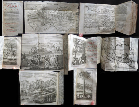
These two beautiful leather bound volumes of William Dampiers voyages to America, New Holland (Australia) and the East Indies, contains 5 titles with 20 maps & plates (some folding) and was published in Amsterdam by David Paul Marret in 1723 (dated)
These 2 volumes are the French translation of the voyages of the English explorer, ex-pirate and navigator, William Dampier, who became the first Englishman to explore parts of what is today Australia, and the first person to circumnavigate the world three times between 1679 & 1711. He has also been described as Australia\'s first natural historian, as well as one of the most important British explorers of the period between Sir Walter Raleigh and James Cook.
After impressing the British Admiralty with his book, A New Voyage Round the World, Dampier was given command of a Royal Navy ship and made important discoveries in western Australia, but was court-martialled for cruelty. On a later voyage, he rescued Alexander Selkirk, a former crew mate who may have inspired Daniel Defoe\'s Robinson Crusoe. Others influenced by Dampier include James Cook, Lord Nelson, Charles Darwin and Alfred Russel Wallace.
General Definitions:
Paper thickness and quality: - Heavy and stable
Paper color : - off white
Age of map color: -
Colors used: -
General color appearance: -
Paper size: - 8vo
Plate size: - 8vo
Margins: - Min 1/2in (12mm)
Imperfections:
Margins: - Please see below for condition report
Plate area: - Please see below for condition report
Verso: - Please see below for condition report
Background:
The two volumes contain the following 5 titles with 20 maps & plates.
Volume 1.
1. Nouveau Voyage Autour Du Monde...Ou l\'on decrite en particular l\'Isthme de l\'Amerique, plusieurs côtes et isles des Indes Occidentales, les Isles du Cap Verd, le passage par la Terre del Fuego, les côtes meridionales du Chili, du Perou & du Mexique; l\'Isle de Guam, Mindanao, & des autres Philippines, les isles orientales qui sont prés de Cambodie; de la Chine; Formosa; Luçon, Celebes, &c., la Nouvelle Hollande, les Isles de Sumatra, de Nicobar & de Sainte Helene & le Cap de Bonne Esperance...Ou l\'on traite des differens terroirs de tous ces pays, de leurs ports, des plantes, des fruits & des animaux qu\'on y trouve; de leurs habitans, de leurs coûtumes, de leur religion, de leur gouvernement, de leur negoce, &c....1723
This volume refers to Dampiers voyages to North & South America, East Indies, SE Asia, China, Australia & Africa.
Contains Title page, 8 maps & plates total of 340 pages.
a) Mappe-Monde - World map with Dampiers tracks.
b) Maps of the Isthmus of Panama and Central America
c) Print of Natives gathering fruit
d) Print of Dampier loading Gold from the New World
e) Voyage au tour du Monde title page
f) Map of Mexico & southern North America
g) Print of a battle in the East indies
h) Print of a coconut palm in East Indies
2. Suite du Voyage Autour du Monde... Avec un Traite Des Vents qui regnent dans toute..LA ZONE TORRIDE Enrichi de Cartes & de Figures..1723
This volume refers to the contuinuation of Dampiers voyages to North & South America, East Indies, SE Asia, China, Australia & Africa along with a description of global winds and tides.
Contains title page along with 6 maps & plates, 227 pages.
a) Engraved Voyage au Tour Du Monde
b) Print of ships offshore from the city of Manila in the Phillippines
c) View of Manila
d) 2nd print of ships offshore from the city of Manila in the Phillippines
e) Map of the Philippines islands of Banshee
f) Map of Pulocondor, Malayia
g) Print of Dampiers ship and compass rose
3. Traits des Vents Aliisez ou Reglez des Vents Frais ...1715
This volume refers again to globle winds & tides.
Contains title page 2 maps & 148 pages
a) Description of winds and tides in the eastern hemisphere
b) Description of winds and tides in the eastern hemisphere
Volume 2.
1. Voyage Autour Du Monde... Contenant une Description d\'Achin,
Ville de Sumatra, du Royaume de Tonquin & autres Places des Indes,
& de la Baye de Campeche. Ou l\'on traite des differens terroirs de tous ces pays, de leurs ports, des plantes, des fruits & des animaux qu\'on y trouve; de leurs
habitans, de leurs coûtumes, de leur religion, de leur gouvernement,
de leur negoce, &c...1723
This volume refers to the continuation of Dampiers travels in East Indies, SE Asia & Mexico
Contains title page, 4 maps & plates, 264 pages.
a) Royalty in Vietnam
b) Map of central & north America
b) Print of Vietnam
c) Map of Australia & East Indies
2. Voyages de Guillaume Dampier a la Baye de Campeche...1714
This volume refers to Dampiers travel to Campeche, Mexico.
Contains title page and 197 pages.
Condition Report: Two volumes bound in full leather with five raised bands to spines, and title label. Couple of minor chips to top of both spines. The leather is scuffed and little pitted/worn (see photos). Internally there are a couple of small chips to inner edges of front and rear end-papers. Inscription to front end-papers (Gift of W. Wood 1745) and bookplate to inside front board (Lord Sandys). The title page of volume III and following four or so leaves have damp staining, and there is light damp staining throughout Volume I & II. The damp staining has caused the leaves to become softer and little chipped, with some nicks/tears and chips. There is a tear/crease to top inner edge and chip to bottom corner of title page of volume I. Scattered pale foxing/browning. Several of the plates have occasional creases. Four leaves of volume III are gently detaching and two leaves of volume I are missing. A few leaves are a little faded. Overall VG, in readable with firm binding.
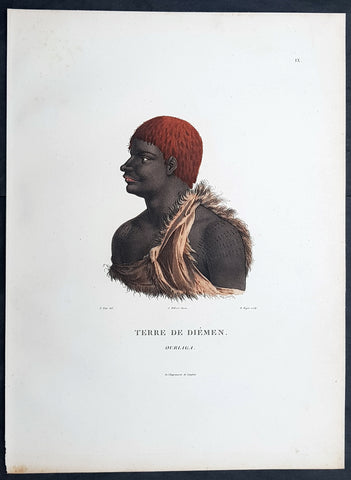
1807 Nicolas Baudin & N M Petit Antique Print of Tasmanian Aboriginal, Ourlaga
- Title : Terre De Diemen Ourlaga
- Size: 14in x 10in (355mm x 255mm)
- Condition: (A+) Fine Condition
- Date : 1807
- Ref #: 93089
Description:
This exquisite, rare original hand coloured copper-plate engraved antique print of Tasmanian Ourlaga, visited by Baudin Expedition to Australia in Feb. 1802, was engraved by Barthélemy Roger, after Nicolas-Martin Petit (the offical artist on the ship Géographe) and was published by Francois Peron (1775 - 1810) in the 1st edition atlas of Nicolas Thomas Baudins expedition to Australia Voyage de découvertes aux Terres Australes
General Definitions:
Paper thickness and quality: - Heavy and stable
Paper color : - off white
Age of map color: - Original
Colors used: - Yellow, green, blue, pink
General color appearance: - Authentic
Paper size: - 14in x 10in (355mm x 255mm)
Plate size: - 14in x 10in (355mm x 255mm)
Margins: - Min 1/2in (12mm)
Imperfections:
Margins: - None
Plate area: - None
Verso: - None
Background:
The Baudin Expedition of 1800 to 1803 was a French expedition to map the coast of New Holland, Australia. The expedition started with two ships, Géographe, captained by Baudin, and Naturaliste captained by Jacques Hamelin, and was accompanied by nine zoologists and botanists, including Jean-Baptiste Leschenault de la Tour, François Péron and Charles-Alexandre Lesueur as well as the geographer Pierre Faure.
The Baudin expedition departed Le Havre, France, on 19 October 1800. Because of delays in receiving his instructions and problems encountered in Isle de France (now Mauritius) they did not reach Cape Leeuwin on the south-west corner of Australia until May 1801. Upon rounding Cape Naturaliste, they entered Geographe Bay. They then sailed north, but the ships became separated and did not meet again until they reached Timor. On their journeys the Géographe and the Naturaliste surveyed large stretches of the north-western coast. The expedition was severely affected by dysentery and fever, but sailed from Timor on 13 November 1801, back down the north-west and west coast, then across the Great Australian Bight, reaching Tasmania on 13 January 1802. They charted the whole length of Tasmanias east coast and there were extensive interactions with the Indigenous Tasmanians, with whom they had peaceful relationships. They notably produced precious ethnological studies of Indigenous Tasmanians.
The expedition then began surveying the south coast of Australia, but then Captain Jacques Felix Emmanuel Hamelin in Naturaliste decided to make for Port Jackson (Sydney) as he was running short of food and water, and in need of anchors. En route, in April 1802, Hamelin explored the area of Western Port, Victoria, and gave names to places, a number of which have survived, for example, Ile des Français is now called French Island.
Meanwhile, Baudin in the Géographe continued westward, and in April 1802 encountered the British ship Investigator commanded by Matthew Flinders, also engaged in charting the coastline, at Encounter Bay in what is now South Australia. Flinders informed Baudin of his discovery of Kangaroo Island, St. Vincents and Spencers Gulfs. Baudin sailed on to the Nuyts Archipelago, the point reached by t Gulden Zeepaert in 1627 before heading for Port Jackson as well for supplies.
In late 1802 the expedition was at Port Jackson, where the government sold 60 casks of flour and 25 casks of salt meat to Baudin to resupply his two vessels. The supplies permitted Naturaliste to return to France and Géographe to continue her explorations of the Australian coast. Naturaliste took with her the Colonys staff surgeon, Mr. James Thomson, whom Governor Philip Gidley King had given permission to return to England.
Before resuming the voyage Baudin purchased a 30 ton schooner, which he named the Casuarina, a smaller vessel which could conduct close inshore survey work. He sent the larger Naturaliste under Hamelin back to France with all the specimens that had been collected by Baudin and his crew. As the voyage had progressed Louis de Freycinet, now a Lieutenant, had shown his talents as an officer and a hydrographer and so was given command of the Casuarina. The expedition then headed for Tasmania and conducted further charting of Bass Strait before sailing west, following the west coast northward, and after another visit to Timor, undertook further exploration along the north coast of Australia. Plagued by contrary winds, ill health, and because the quadrupeds and emus were very sick, it was decided on 7 July 1803 to return to France. On the return voyage, the ships stopped in Mauritius, where Baudin died of tuberculosis on 16 September 1803. The expedition finally reached France on 24 March 1804.
The scientific expedition was considered a great success, with more than 2500 new species discovered.
Nicolas-Martin Petit 1777 – 1804
Nicholas-Martin Petit was born in Paris, the son of a fan maker, and learned graphic art in the studio of Jacques Louis David. He avoided conscription into Napoleons armies, but wanting to travel, signed up with post Captain Nicholas Baudin on a voyage to the antipodes sponsored by the French government. Petit and fellow artist Charles-Alexandre Lesueur were enlisted directly by Baudin (as 4th class gunners mates) while the two official artists were hired by the organisers of the expedition. Baudin set off in two lavishly equipped vessels, the Géographe and the Naturaliste on 19 October 1800. By the time the expedition reached Mauritius the official artists had quit. Petit and Lesueur took over their duties, but as neither was trained in scientific method or presentation, the value of their work was primarily aesthetic. The French were at this time developing a new scientific field - anthropology. The Society of the Observers of Man was founded in 1799 for this purpose. The study of Man formed part of the background for Petits sensitive drawings and paintings of the indigenous people of Van Diemens Land, Port Jackson and Western Australia. Lesueur focused on the depiction of animals. The expedition charted the coast of Western Australia and Van Diemens land but was plagued by scurvy. On 20 June 1802 the two ships limped into Port Jackson and stayed for five months to refit, during which time Petit completed a number of portraits of Sydney Indigenous people, including the two images of the Eora men, Cour-rou-bari-gal and Y-erren-gou-la-ga. Petit eventually returned to France in 1804. However, before he was well enough to complete the drawings from the expedition he was hurt in a street accident, and he died at the age of 28. Petits unfinished work was first published in 1807 in the Atlas of the Voyage de découvertes aux terres australes and as discrete prints.
Baudin, Nicolas Thomas 1754 – 1803
Baudin was a French explorer, cartographer, naturalist and hydrographer. Born a commoner in Saint-Martin-de-Ré on the Île de Ré on 17 February 1754 Baudin joined the merchant navy at the age of 15 and the French East India Company at the age of 20.
Baudin then joined the La Marine Royale (French Navy) in 1774 and served in the Caribbean as an officier bleu during the American War of Independence of 1775–1783.
In 1785 Baudin and his brother Alexandre were respectively masters of the St Remy and Caroline, taking Acadian settlers from Nantes to La Nouvelle Orléans. In New Orleans local merchants contracted him to take a cargo of wood, salted meat, cod and flour to Isle de France (now Mauritius), which he did in Josephine (also called Pepita), departing New Orleans on 14 July 1786 and arriving at Isle de France on 27 March 1787. In the course of the voyage, Josephine had called at Cap‑Français in Haiti to make a contract to transport slaves there from Madagascar; while in Haiti he also encountered the Austrian botanist Franz Josef Maerter, who apparently informed him that another Austrian botanist, Franz Boos, was at the Cape of Good Hope awaiting a ship to take him to Mauritius. Josephine called at the Cape and took Boos on board. At Mauritius, Boos chartered Baudin to transport him and the collection of plant specimens he had gathered there and at the Cape back to Europe, which Baudin did, Josephine arriving at Trieste on 18 June 1788. The Imperial government in Vienna was contemplating organizing another natural-history expedition, to which Boos would be appointed, in which two ships would be sent to the Malabar and Coromandel coasts of India, the Persian Gulf, Bengal, Ceylon, Sumatra, Java, Borneo, Cochin China, Tongking, Japan and China. Baudin had been given reason to hope that he would be given command of the ships of this expedition.
Later in 1788 Baudin sailed on a commercial voyage from Trieste to Canton in Jardiniere. He apparently arrived at Canton from Mauritius under the flag of the United States of America, probably to avoid the possibility of having his ship seized by the Chinese for payment of the debts owed them by the Imperial Asiatic Company of Trieste. From there, he sent Jardiniere under her second captain on a fur-trading venture to the north-west coast of America, but the ship foundered off Asuncion Island in the Marianas in late 1789.
Baudin made his way to Mauritius, where he purchased a replacement ship, Jardiniere II, but this vessel was wrecked in a cyclone that struck Port Louis on 15 December 1789. Baudin embarked on the Spanish Royal Philippines Company ship, Placeres, which sailed from Port Louis for Cadiz in August 1790. Placeres called at the Cape of Good Hope where it took on board the large number of plant and animal specimens collected in South Africa for the Imperial palace at Schönbrunn by Georg Scholl, the assistant of Franz Boos. Because of the poor condition of the ship, Placeres had to put in at the island of Trinidad in the West Indies, where Scholls collection of specimens was deposited.
Baudin proceeded to Martinique, from where he addressed an offer to the Imperial government in Vienna to conduct to Canton commissioners who would be empowered to negotiate with the Chinese merchants there a settlement of the debts incurred by the Imperial Asiatic Company, which would enable the company to renew its trade with China. On its return voyage from Canton, the proposed expedition would call at the Cape of Good Hope to pick up Scholl and the remainder of his natural-history collection for conveyance to Schönbrunn.
After returning to Vienna in September 1791, Baudin continued to press his case for an expedition under the Imperial flag to the Indian Ocean and China, and in January 1792 he was granted a commission of captain in the Imperial navy for this purpose. A ship, called Jardiniere, was acquired and the botanists Franz Bredemeyer and Joseph van der Schot appointed to the expedition. After delays caused by the outbreak of war between France and Austria (April 1792), Jardiniere departed from the Spanish port of Málaga on 1 October 1792. From the Cape of Good Hope Jardiniere sailed across the Indian Ocean to the coast of New Holland (Australia), but two consecutive cyclones prevented the expedition from doing any work there and forced Baudin to take the ship to Bombay for repairs.
From Bombay the expedition proceeded to the Persian Gulf, the Red Sea and the east coast of Africa, where it gathered botanical and zoological collections. The expedition came to an abrupt end in June 1794 when Jardiniere went aground in a storm while attempting to enter Table Bay at the Cape of Good Hope. Baudin survived the wreck and made his way to the United States, from where he went to France. He managed to send Jardinieres cargo of natural history specimens to the island of Trinidad.
In Paris, Baudin visited Antoine de Jussieu at the Museum National dHistoire Naturelle in March 1796 to suggest a botanical voyage to the Caribbean, during which he would recover the collection of specimens he had left in Trinidad. The Museum and the French government accepted the proposal, and Baudin was appointed commander of an expedition in the ship Belle Angélique, with four assigned botanists: René Maugé, André Pierre Ledru, Anselme Riedlé and Stanislas Levillain. Belle Angélique cleared Le Havre on 30 September 1796 for the Canary Islands, where the ship was condemned as unseaworthy. The expedition sailed from the Canaries in a replacement vessel, Fanny, and reached Trinidad in April 1797. The British, who had just captured the island from the Spanish in February 1797, refused to allow Baudin to recover the collection of natural-history specimens. Baudin took Fanny to St. Thomas and St. Croix, and then to Puerto Rico, specimens being collected in all three islands. At St Croix, Fanny was replaced by a newly purchased ship, renamed Belle Angelique. The expedition returned to France in June 1798 with a large collection of plants, birds and insects, which was incorporated into Napoleon Bonapartes triumphal procession celebrating his recent Italian victories.
On 24 July 1798, at the suggestion of the Ministry of Marine, Baudin presented to the Assembly of Professors and Administrators of the National Museum of Natural History a plan for a hydrographic-survey expedition to the South Seas, which would include a search for fauna and flora that could be brought back for cultivation in France. The expedition would also have the aim of promoting the economic and commercial interests of France in the regions to be visited. The expedition would require two well-equipped ships, which would carry a team of astronomers, naturalists and scientific draughtsmen over whom Baudin as commander would have absolute authority. The first part of the voyage would be devoted to a thorough exploration of the coast of Chile and the collection of animal, bird and plant specimens suitable for acclimatization in France, followed by a survey of the coasts from Peru to Mexico. The expedition would then continue into the Pacific Ocean, including a visit to Tahiti and the Society Islands, and would be completed with a survey of the yet unexplored south-west coast of New Holland (Australia). After considering this extensive proposal, the French government decided to proceed with an expedition confined to a survey of western and southern New Holland (as Australia was called at the time).
In October 1800 Baudin was selected to lead what has become known as the Baudin expedition to map the coast of Australia (New Holland). He had two ships, Géographe and Naturaliste captained by Hamelin, and a suite of nine zoologists and botanists, including Jean Baptiste Leschenault de la Tour. He reached Australia in May 1801, and would explore and map the western coast and a part of the little-known southern coast of the continent. The scientific expedition proved a great success, with more than 2500 new species discovered. The French also met Aboriginal peoples and treated them with great respect.
In April 1802 Baudin met Matthew Flinders, also engaged in charting the coastline, in Encounter Bay in present-day South Australia. Baudin then stopped at the British colony at Sydney for supplies. In Sydney he bought a new ship — Casuarina — named after the wood it was made from. From there he sent home Naturaliste, which had on board all of the specimens that had been discovered by Baudin and his crew. He then headed for Tasmania, before continuing north to Timor. Baudin then sailed for home, stopping at Mauritius.
According to recent researches by academics from the University of Adelaide, during Baudins expedition, François Péron, who had become the chief zoologist and intellectual leader of the mission, wrote a report for Napoleon on ways to invade and capture the British colony at Sydney Cove.
Baudin died of tuberculosis at Mauritius on 16 September 1803, at the age of 49, apparently in the home of Madame Alexandrine Kerivel. Baudins exact resting place is not known, but the historian Auguste Toussaint believed that he was interred in the Kerivel family vault. However, the historian Edward Duyker likes to think that Baudin was buried in Le Cimetière de lOuest in the district of Port Louis just a few hundred metres from the explorers certain love: the sea.
Please note all items auctioned are genuine, we do not sell reproductions. A Certificate of Authenticity (COA) can be issued on request.
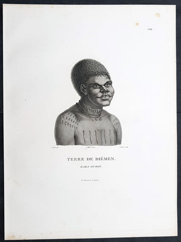
1807 Nicolas Baudin & N M Petit Antique Print of Tasmanian Aboriginal Bara-Ourou
- Title : Terre De Diemen Bara-Ourou
- Size: 13in x 10in (330mm x 255mm)
- Condition: (A+) Fine Condition
- Date : 1807
- Ref #: 93088
Description:
This exquisite, rare original copper-plate engraved antique print of Tasmanian Bara-Ourou, portrait of a young man 28-30 years of age, visited by Baudin Expedition to Australia in Feb. 1802, was engraved by Barthélemy Roger, after Nicolas-Martin Petit (the offical artist on the ship Géographe) and was published by Francois Peron (1775 - 1810) in the 1st edition atlas of Nicolas Thomas Baudins expedition to Australia Voyage de découvertes aux Terres Australes
Nicholas Martin Petit sailed with Nicolas Baudin on the expedition of the Géographe and the Naturaliste in late 1800. The scientific field of anthropology was in its infancy – the French had founded the Society of the Observers of Man in 1799. Having embarked as a fourth-class gunner’s mate, Petit, who had had some graphic arts training, became one of the expeditions two illustrators when the official artists quit. From June to November 1802, the expedition was delayed in Sydney while its two ships were repaired. During this time Petit completed portraits of people of the Cadigal, Dharawal, Gweagal, Kurringai and Darug language groups of the Sydney Harbour region. While the sitters names appear to be noted on the works, it is possible that the inscriptions merely reflect French misinterpretation of the Aborigines communications with them.
The portrait of Nourou-gal-derri is pictured advancing for battle.
General Definitions:
Paper thickness and quality: - Heavy and stable
Paper color : - off white
Age of map color: -
Colors used: -
General color appearance: -
Paper size: - 14in x 10in (355mm x 255mm)
Plate size: - 14in x 10in (355mm x 255mm)
Margins: - Min 1/2in (12mm)
Imperfections:
Margins: - None
Plate area: - None
Verso: - None
Background:
The Baudin Expedition of 1800 to 1803 was a French expedition to map the coast of New Holland, Australia. The expedition started with two ships, Géographe, captained by Baudin, and Naturaliste captained by Jacques Hamelin, and was accompanied by nine zoologists and botanists, including Jean-Baptiste Leschenault de la Tour, François Péron and Charles-Alexandre Lesueur as well as the geographer Pierre Faure.
The Baudin expedition departed Le Havre, France, on 19 October 1800. Because of delays in receiving his instructions and problems encountered in Isle de France (now Mauritius) they did not reach Cape Leeuwin on the south-west corner of Australia until May 1801. Upon rounding Cape Naturaliste, they entered Geographe Bay. They then sailed north, but the ships became separated and did not meet again until they reached Timor. On their journeys the Géographe and the Naturaliste surveyed large stretches of the north-western coast. The expedition was severely affected by dysentery and fever, but sailed from Timor on 13 November 1801, back down the north-west and west coast, then across the Great Australian Bight, reaching Tasmania on 13 January 1802. They charted the whole length of Tasmanias east coast and there were extensive interactions with the Indigenous Tasmanians, with whom they had peaceful relationships. They notably produced precious ethnological studies of Indigenous Tasmanians.
The expedition then began surveying the south coast of Australia, but then Captain Jacques Felix Emmanuel Hamelin in Naturaliste decided to make for Port Jackson (Sydney) as he was running short of food and water, and in need of anchors. En route, in April 1802, Hamelin explored the area of Western Port, Victoria, and gave names to places, a number of which have survived, for example, Ile des Français is now called French Island.
Meanwhile, Baudin in the Géographe continued westward, and in April 1802 encountered the British ship Investigator commanded by Matthew Flinders, also engaged in charting the coastline, at Encounter Bay in what is now South Australia. Flinders informed Baudin of his discovery of Kangaroo Island, St. Vincents and Spencers Gulfs. Baudin sailed on to the Nuyts Archipelago, the point reached by t Gulden Zeepaert in 1627 before heading for Port Jackson as well for supplies.
In late 1802 the expedition was at Port Jackson, where the government sold 60 casks of flour and 25 casks of salt meat to Baudin to resupply his two vessels. The supplies permitted Naturaliste to return to France and Géographe to continue her explorations of the Australian coast. Naturaliste took with her the Colonys staff surgeon, Mr. James Thomson, whom Governor Philip Gidley King had given permission to return to England.
Before resuming the voyage Baudin purchased a 30 ton schooner, which he named the Casuarina, a smaller vessel which could conduct close inshore survey work. He sent the larger Naturaliste under Hamelin back to France with all the specimens that had been collected by Baudin and his crew. As the voyage had progressed Louis de Freycinet, now a Lieutenant, had shown his talents as an officer and a hydrographer and so was given command of the Casuarina. The expedition then headed for Tasmania and conducted further charting of Bass Strait before sailing west, following the west coast northward, and after another visit to Timor, undertook further exploration along the north coast of Australia. Plagued by contrary winds, ill health, and because the quadrupeds and emus were very sick, it was decided on 7 July 1803 to return to France. On the return voyage, the ships stopped in Mauritius, where Baudin died of tuberculosis on 16 September 1803. The expedition finally reached France on 24 March 1804.
The scientific expedition was considered a great success, with more than 2500 new species discovered.
Nicolas-Martin Petit 1777 – 1804
Nicholas-Martin Petit was born in Paris, the son of a fan maker, and learned graphic art in the studio of Jacques Louis David. He avoided conscription into Napoleons armies, but wanting to travel, signed up with post Captain Nicholas Baudin on a voyage to the antipodes sponsored by the French government. Petit and fellow artist Charles-Alexandre Lesueur were enlisted directly by Baudin (as 4th class gunners mates) while the two official artists were hired by the organisers of the expedition. Baudin set off in two lavishly equipped vessels, the Géographe and the Naturaliste on 19 October 1800. By the time the expedition reached Mauritius the official artists had quit. Petit and Lesueur took over their duties, but as neither was trained in scientific method or presentation, the value of their work was primarily aesthetic. The French were at this time developing a new scientific field - anthropology. The Society of the Observers of Man was founded in 1799 for this purpose. The study of Man formed part of the background for Petits sensitive drawings and paintings of the indigenous people of Van Diemens Land, Port Jackson and Western Australia. Lesueur focused on the depiction of animals. The expedition charted the coast of Western Australia and Van Diemens land but was plagued by scurvy. On 20 June 1802 the two ships limped into Port Jackson and stayed for five months to refit, during which time Petit completed a number of portraits of Sydney Indigenous people, including the two images of the Eora men, Cour-rou-bari-gal and Y-erren-gou-la-ga. Petit eventually returned to France in 1804. However, before he was well enough to complete the drawings from the expedition he was hurt in a street accident, and he died at the age of 28. Petits unfinished work was first published in 1807 in the Atlas of the Voyage de découvertes aux terres australes and as discrete prints.
Baudin, Nicolas Thomas 1754 – 1803
Baudin was a French explorer, cartographer, naturalist and hydrographer. Born a commoner in Saint-Martin-de-Ré on the Île de Ré on 17 February 1754 Baudin joined the merchant navy at the age of 15 and the French East India Company at the age of 20.
Baudin then joined the La Marine Royale (French Navy) in 1774 and served in the Caribbean as an officier bleu during the American War of Independence of 1775–1783.
In 1785 Baudin and his brother Alexandre were respectively masters of the St Remy and Caroline, taking Acadian settlers from Nantes to La Nouvelle Orléans. In New Orleans local merchants contracted him to take a cargo of wood, salted meat, cod and flour to Isle de France (now Mauritius), which he did in Josephine (also called Pepita), departing New Orleans on 14 July 1786 and arriving at Isle de France on 27 March 1787. In the course of the voyage, Josephine had called at Cap‑Français in Haiti to make a contract to transport slaves there from Madagascar; while in Haiti he also encountered the Austrian botanist Franz Josef Maerter, who apparently informed him that another Austrian botanist, Franz Boos, was at the Cape of Good Hope awaiting a ship to take him to Mauritius. Josephine called at the Cape and took Boos on board. At Mauritius, Boos chartered Baudin to transport him and the collection of plant specimens he had gathered there and at the Cape back to Europe, which Baudin did, Josephine arriving at Trieste on 18 June 1788. The Imperial government in Vienna was contemplating organizing another natural-history expedition, to which Boos would be appointed, in which two ships would be sent to the Malabar and Coromandel coasts of India, the Persian Gulf, Bengal, Ceylon, Sumatra, Java, Borneo, Cochin China, Tongking, Japan and China. Baudin had been given reason to hope that he would be given command of the ships of this expedition.
Later in 1788 Baudin sailed on a commercial voyage from Trieste to Canton in Jardiniere. He apparently arrived at Canton from Mauritius under the flag of the United States of America, probably to avoid the possibility of having his ship seized by the Chinese for payment of the debts owed them by the Imperial Asiatic Company of Trieste. From there, he sent Jardiniere under her second captain on a fur-trading venture to the north-west coast of America, but the ship foundered off Asuncion Island in the Marianas in late 1789.
Baudin made his way to Mauritius, where he purchased a replacement ship, Jardiniere II, but this vessel was wrecked in a cyclone that struck Port Louis on 15 December 1789. Baudin embarked on the Spanish Royal Philippines Company ship, Placeres, which sailed from Port Louis for Cadiz in August 1790. Placeres called at the Cape of Good Hope where it took on board the large number of plant and animal specimens collected in South Africa for the Imperial palace at Schönbrunn by Georg Scholl, the assistant of Franz Boos. Because of the poor condition of the ship, Placeres had to put in at the island of Trinidad in the West Indies, where Scholls collection of specimens was deposited.
Baudin proceeded to Martinique, from where he addressed an offer to the Imperial government in Vienna to conduct to Canton commissioners who would be empowered to negotiate with the Chinese merchants there a settlement of the debts incurred by the Imperial Asiatic Company, which would enable the company to renew its trade with China. On its return voyage from Canton, the proposed expedition would call at the Cape of Good Hope to pick up Scholl and the remainder of his natural-history collection for conveyance to Schönbrunn.
After returning to Vienna in September 1791, Baudin continued to press his case for an expedition under the Imperial flag to the Indian Ocean and China, and in January 1792 he was granted a commission of captain in the Imperial navy for this purpose. A ship, called Jardiniere, was acquired and the botanists Franz Bredemeyer and Joseph van der Schot appointed to the expedition. After delays caused by the outbreak of war between France and Austria (April 1792), Jardiniere departed from the Spanish port of Málaga on 1 October 1792. From the Cape of Good Hope Jardiniere sailed across the Indian Ocean to the coast of New Holland (Australia), but two consecutive cyclones prevented the expedition from doing any work there and forced Baudin to take the ship to Bombay for repairs.
From Bombay the expedition proceeded to the Persian Gulf, the Red Sea and the east coast of Africa, where it gathered botanical and zoological collections. The expedition came to an abrupt end in June 1794 when Jardiniere went aground in a storm while attempting to enter Table Bay at the Cape of Good Hope. Baudin survived the wreck and made his way to the United States, from where he went to France. He managed to send Jardinieres cargo of natural history specimens to the island of Trinidad.
In Paris, Baudin visited Antoine de Jussieu at the Museum National dHistoire Naturelle in March 1796 to suggest a botanical voyage to the Caribbean, during which he would recover the collection of specimens he had left in Trinidad. The Museum and the French government accepted the proposal, and Baudin was appointed commander of an expedition in the ship Belle Angélique, with four assigned botanists: René Maugé, André Pierre Ledru, Anselme Riedlé and Stanislas Levillain. Belle Angélique cleared Le Havre on 30 September 1796 for the Canary Islands, where the ship was condemned as unseaworthy. The expedition sailed from the Canaries in a replacement vessel, Fanny, and reached Trinidad in April 1797. The British, who had just captured the island from the Spanish in February 1797, refused to allow Baudin to recover the collection of natural-history specimens. Baudin took Fanny to St. Thomas and St. Croix, and then to Puerto Rico, specimens being collected in all three islands. At St Croix, Fanny was replaced by a newly purchased ship, renamed Belle Angelique. The expedition returned to France in June 1798 with a large collection of plants, birds and insects, which was incorporated into Napoleon Bonapartes triumphal procession celebrating his recent Italian victories.
On 24 July 1798, at the suggestion of the Ministry of Marine, Baudin presented to the Assembly of Professors and Administrators of the National Museum of Natural History a plan for a hydrographic-survey expedition to the South Seas, which would include a search for fauna and flora that could be brought back for cultivation in France. The expedition would also have the aim of promoting the economic and commercial interests of France in the regions to be visited. The expedition would require two well-equipped ships, which would carry a team of astronomers, naturalists and scientific draughtsmen over whom Baudin as commander would have absolute authority. The first part of the voyage would be devoted to a thorough exploration of the coast of Chile and the collection of animal, bird and plant specimens suitable for acclimatization in France, followed by a survey of the coasts from Peru to Mexico. The expedition would then continue into the Pacific Ocean, including a visit to Tahiti and the Society Islands, and would be completed with a survey of the yet unexplored south-west coast of New Holland (Australia). After considering this extensive proposal, the French government decided to proceed with an expedition confined to a survey of western and southern New Holland (as Australia was called at the time).
In October 1800 Baudin was selected to lead what has become known as the Baudin expedition to map the coast of Australia (New Holland). He had two ships, Géographe and Naturaliste captained by Hamelin, and a suite of nine zoologists and botanists, including Jean Baptiste Leschenault de la Tour. He reached Australia in May 1801, and would explore and map the western coast and a part of the little-known southern coast of the continent. The scientific expedition proved a great success, with more than 2500 new species discovered. The French also met Aboriginal peoples and treated them with great respect.
In April 1802 Baudin met Matthew Flinders, also engaged in charting the coastline, in Encounter Bay in present-day South Australia. Baudin then stopped at the British colony at Sydney for supplies. In Sydney he bought a new ship — Casuarina — named after the wood it was made from. From there he sent home Naturaliste, which had on board all of the specimens that had been discovered by Baudin and his crew. He then headed for Tasmania, before continuing north to Timor. Baudin then sailed for home, stopping at Mauritius.
According to recent researches by academics from the University of Adelaide, during Baudins expedition, François Péron, who had become the chief zoologist and intellectual leader of the mission, wrote a report for Napoleon on ways to invade and capture the British colony at Sydney Cove.
Baudin died of tuberculosis at Mauritius on 16 September 1803, at the age of 49, apparently in the home of Madame Alexandrine Kerivel. Baudins exact resting place is not known, but the historian Auguste Toussaint believed that he was interred in the Kerivel family vault. However, the historian Edward Duyker likes to think that Baudin was buried in Le Cimetière de lOuest in the district of Port Louis just a few hundred metres from the explorers certain love: the sea.
Please note all items auctioned are genuine, we do not sell reproductions. A Certificate of Authenticity (COA) can be issued on request.
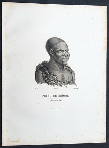
1807 Nicolas Baudin & N M Petit Antique Print of Tasmanian Aboriginal Grou Agara
- Title : Terre De Diemen Grou Agara
- Size: 13in x 10in (330mm x 255mm)
- Condition: (A+) Fine Condition
- Date : 1807
- Ref #: 93086
Description:
This exquisite, rare original copper-plate engraved antique print of Tasmanian Aboriginal Grou Agara, visited by the Baudin Expedition to Australia in Feb. 1802, was engraved by Barthélemy Roger, after Nicolas-Martin Petit (the offical artist on the ship Géographe) and was published by Francois Peron (1775 - 1810) in the 1st edition atlas of Nicolas Thomas Baudins expedition to Australia Voyage de découvertes aux Terres Australes
Nicholas Martin Petit sailed with Nicolas Baudin on the expedition of the Géographe and the Naturaliste in late 1800. The scientific field of anthropology was in its infancy – the French had founded the Society of the Observers of Man in 1799. Having embarked as a fourth-class gunner’s mate, Petit, who had had some graphic arts training, became one of the expeditions two illustrators when the official artists quit. From June to November 1802, the expedition was delayed in Sydney while its two ships were repaired. During this time Petit completed portraits of people of the Cadigal, Dharawal, Gweagal, Kurringai and Darug language groups of the Sydney Harbour region. While the sitters names appear to be noted on the works, it is possible that the inscriptions merely reflect French misinterpretation of the Aborigines communications with them.
The portrait of Nourou-gal-derri is pictured advancing for battle.
General Definitions:
Paper thickness and quality: - Heavy and stable
Paper color : - off white
Age of map color: -
Colors used: -
General color appearance: -
Paper size: - 14in x 10in (355mm x 255mm)
Plate size: - 14in x 10in (355mm x 255mm)
Margins: - Min 1/2in (12mm)
Imperfections:
Margins: - None
Plate area: - None
Verso: - None
Background:
The Baudin Expedition of 1800 to 1803 was a French expedition to map the coast of New Holland, Australia. The expedition started with two ships, Géographe, captained by Baudin, and Naturaliste captained by Jacques Hamelin, and was accompanied by nine zoologists and botanists, including Jean-Baptiste Leschenault de la Tour, François Péron and Charles-Alexandre Lesueur as well as the geographer Pierre Faure.
The Baudin expedition departed Le Havre, France, on 19 October 1800. Because of delays in receiving his instructions and problems encountered in Isle de France (now Mauritius) they did not reach Cape Leeuwin on the south-west corner of Australia until May 1801. Upon rounding Cape Naturaliste, they entered Geographe Bay. They then sailed north, but the ships became separated and did not meet again until they reached Timor. On their journeys the Géographe and the Naturaliste surveyed large stretches of the north-western coast. The expedition was severely affected by dysentery and fever, but sailed from Timor on 13 November 1801, back down the north-west and west coast, then across the Great Australian Bight, reaching Tasmania on 13 January 1802. They charted the whole length of Tasmanias east coast and there were extensive interactions with the Indigenous Tasmanians, with whom they had peaceful relationships. They notably produced precious ethnological studies of Indigenous Tasmanians.
The expedition then began surveying the south coast of Australia, but then Captain Jacques Felix Emmanuel Hamelin in Naturaliste decided to make for Port Jackson (Sydney) as he was running short of food and water, and in need of anchors. En route, in April 1802, Hamelin explored the area of Western Port, Victoria, and gave names to places, a number of which have survived, for example, Ile des Français is now called French Island.
Meanwhile, Baudin in the Géographe continued westward, and in April 1802 encountered the British ship Investigator commanded by Matthew Flinders, also engaged in charting the coastline, at Encounter Bay in what is now South Australia. Flinders informed Baudin of his discovery of Kangaroo Island, St. Vincents and Spencers Gulfs. Baudin sailed on to the Nuyts Archipelago, the point reached by t Gulden Zeepaert in 1627 before heading for Port Jackson as well for supplies.
In late 1802 the expedition was at Port Jackson, where the government sold 60 casks of flour and 25 casks of salt meat to Baudin to resupply his two vessels. The supplies permitted Naturaliste to return to France and Géographe to continue her explorations of the Australian coast. Naturaliste took with her the Colonys staff surgeon, Mr. James Thomson, whom Governor Philip Gidley King had given permission to return to England.
Before resuming the voyage Baudin purchased a 30 ton schooner, which he named the Casuarina, a smaller vessel which could conduct close inshore survey work. He sent the larger Naturaliste under Hamelin back to France with all the specimens that had been collected by Baudin and his crew. As the voyage had progressed Louis de Freycinet, now a Lieutenant, had shown his talents as an officer and a hydrographer and so was given command of the Casuarina. The expedition then headed for Tasmania and conducted further charting of Bass Strait before sailing west, following the west coast northward, and after another visit to Timor, undertook further exploration along the north coast of Australia. Plagued by contrary winds, ill health, and because the quadrupeds and emus were very sick, it was decided on 7 July 1803 to return to France. On the return voyage, the ships stopped in Mauritius, where Baudin died of tuberculosis on 16 September 1803. The expedition finally reached France on 24 March 1804.
The scientific expedition was considered a great success, with more than 2500 new species discovered.
Nicolas-Martin Petit 1777 – 1804
Nicholas-Martin Petit was born in Paris, the son of a fan maker, and learned graphic art in the studio of Jacques Louis David. He avoided conscription into Napoleons armies, but wanting to travel, signed up with post Captain Nicholas Baudin on a voyage to the antipodes sponsored by the French government. Petit and fellow artist Charles-Alexandre Lesueur were enlisted directly by Baudin (as 4th class gunners mates) while the two official artists were hired by the organisers of the expedition. Baudin set off in two lavishly equipped vessels, the Géographe and the Naturaliste on 19 October 1800. By the time the expedition reached Mauritius the official artists had quit. Petit and Lesueur took over their duties, but as neither was trained in scientific method or presentation, the value of their work was primarily aesthetic. The French were at this time developing a new scientific field - anthropology. The Society of the Observers of Man was founded in 1799 for this purpose. The study of Man formed part of the background for Petits sensitive drawings and paintings of the indigenous people of Van Diemens Land, Port Jackson and Western Australia. Lesueur focused on the depiction of animals. The expedition charted the coast of Western Australia and Van Diemens land but was plagued by scurvy. On 20 June 1802 the two ships limped into Port Jackson and stayed for five months to refit, during which time Petit completed a number of portraits of Sydney Indigenous people, including the two images of the Eora men, Cour-rou-bari-gal and Y-erren-gou-la-ga. Petit eventually returned to France in 1804. However, before he was well enough to complete the drawings from the expedition he was hurt in a street accident, and he died at the age of 28. Petits unfinished work was first published in 1807 in the Atlas of the Voyage de découvertes aux terres australes and as discrete prints.
Baudin, Nicolas Thomas 1754 – 1803
Baudin was a French explorer, cartographer, naturalist and hydrographer. Born a commoner in Saint-Martin-de-Ré on the Île de Ré on 17 February 1754 Baudin joined the merchant navy at the age of 15 and the French East India Company at the age of 20.
Baudin then joined the La Marine Royale (French Navy) in 1774 and served in the Caribbean as an officier bleu during the American War of Independence of 1775–1783.
In 1785 Baudin and his brother Alexandre were respectively masters of the St Remy and Caroline, taking Acadian settlers from Nantes to La Nouvelle Orléans. In New Orleans local merchants contracted him to take a cargo of wood, salted meat, cod and flour to Isle de France (now Mauritius), which he did in Josephine (also called Pepita), departing New Orleans on 14 July 1786 and arriving at Isle de France on 27 March 1787. In the course of the voyage, Josephine had called at Cap‑Français in Haiti to make a contract to transport slaves there from Madagascar; while in Haiti he also encountered the Austrian botanist Franz Josef Maerter, who apparently informed him that another Austrian botanist, Franz Boos, was at the Cape of Good Hope awaiting a ship to take him to Mauritius. Josephine called at the Cape and took Boos on board. At Mauritius, Boos chartered Baudin to transport him and the collection of plant specimens he had gathered there and at the Cape back to Europe, which Baudin did, Josephine arriving at Trieste on 18 June 1788. The Imperial government in Vienna was contemplating organizing another natural-history expedition, to which Boos would be appointed, in which two ships would be sent to the Malabar and Coromandel coasts of India, the Persian Gulf, Bengal, Ceylon, Sumatra, Java, Borneo, Cochin China, Tongking, Japan and China. Baudin had been given reason to hope that he would be given command of the ships of this expedition.
Later in 1788 Baudin sailed on a commercial voyage from Trieste to Canton in Jardiniere. He apparently arrived at Canton from Mauritius under the flag of the United States of America, probably to avoid the possibility of having his ship seized by the Chinese for payment of the debts owed them by the Imperial Asiatic Company of Trieste. From there, he sent Jardiniere under her second captain on a fur-trading venture to the north-west coast of America, but the ship foundered off Asuncion Island in the Marianas in late 1789.
Baudin made his way to Mauritius, where he purchased a replacement ship, Jardiniere II, but this vessel was wrecked in a cyclone that struck Port Louis on 15 December 1789. Baudin embarked on the Spanish Royal Philippines Company ship, Placeres, which sailed from Port Louis for Cadiz in August 1790. Placeres called at the Cape of Good Hope where it took on board the large number of plant and animal specimens collected in South Africa for the Imperial palace at Schönbrunn by Georg Scholl, the assistant of Franz Boos. Because of the poor condition of the ship, Placeres had to put in at the island of Trinidad in the West Indies, where Scholls collection of specimens was deposited.
Baudin proceeded to Martinique, from where he addressed an offer to the Imperial government in Vienna to conduct to Canton commissioners who would be empowered to negotiate with the Chinese merchants there a settlement of the debts incurred by the Imperial Asiatic Company, which would enable the company to renew its trade with China. On its return voyage from Canton, the proposed expedition would call at the Cape of Good Hope to pick up Scholl and the remainder of his natural-history collection for conveyance to Schönbrunn.
After returning to Vienna in September 1791, Baudin continued to press his case for an expedition under the Imperial flag to the Indian Ocean and China, and in January 1792 he was granted a commission of captain in the Imperial navy for this purpose. A ship, called Jardiniere, was acquired and the botanists Franz Bredemeyer and Joseph van der Schot appointed to the expedition. After delays caused by the outbreak of war between France and Austria (April 1792), Jardiniere departed from the Spanish port of Málaga on 1 October 1792. From the Cape of Good Hope Jardiniere sailed across the Indian Ocean to the coast of New Holland (Australia), but two consecutive cyclones prevented the expedition from doing any work there and forced Baudin to take the ship to Bombay for repairs.
From Bombay the expedition proceeded to the Persian Gulf, the Red Sea and the east coast of Africa, where it gathered botanical and zoological collections. The expedition came to an abrupt end in June 1794 when Jardiniere went aground in a storm while attempting to enter Table Bay at the Cape of Good Hope. Baudin survived the wreck and made his way to the United States, from where he went to France. He managed to send Jardinieres cargo of natural history specimens to the island of Trinidad.
In Paris, Baudin visited Antoine de Jussieu at the Museum National dHistoire Naturelle in March 1796 to suggest a botanical voyage to the Caribbean, during which he would recover the collection of specimens he had left in Trinidad. The Museum and the French government accepted the proposal, and Baudin was appointed commander of an expedition in the ship Belle Angélique, with four assigned botanists: René Maugé, André Pierre Ledru, Anselme Riedlé and Stanislas Levillain. Belle Angélique cleared Le Havre on 30 September 1796 for the Canary Islands, where the ship was condemned as unseaworthy. The expedition sailed from the Canaries in a replacement vessel, Fanny, and reached Trinidad in April 1797. The British, who had just captured the island from the Spanish in February 1797, refused to allow Baudin to recover the collection of natural-history specimens. Baudin took Fanny to St. Thomas and St. Croix, and then to Puerto Rico, specimens being collected in all three islands. At St Croix, Fanny was replaced by a newly purchased ship, renamed Belle Angelique. The expedition returned to France in June 1798 with a large collection of plants, birds and insects, which was incorporated into Napoleon Bonapartes triumphal procession celebrating his recent Italian victories.
On 24 July 1798, at the suggestion of the Ministry of Marine, Baudin presented to the Assembly of Professors and Administrators of the National Museum of Natural History a plan for a hydrographic-survey expedition to the South Seas, which would include a search for fauna and flora that could be brought back for cultivation in France. The expedition would also have the aim of promoting the economic and commercial interests of France in the regions to be visited. The expedition would require two well-equipped ships, which would carry a team of astronomers, naturalists and scientific draughtsmen over whom Baudin as commander would have absolute authority. The first part of the voyage would be devoted to a thorough exploration of the coast of Chile and the collection of animal, bird and plant specimens suitable for acclimatization in France, followed by a survey of the coasts from Peru to Mexico. The expedition would then continue into the Pacific Ocean, including a visit to Tahiti and the Society Islands, and would be completed with a survey of the yet unexplored south-west coast of New Holland (Australia). After considering this extensive proposal, the French government decided to proceed with an expedition confined to a survey of western and southern New Holland (as Australia was called at the time).
In October 1800 Baudin was selected to lead what has become known as the Baudin expedition to map the coast of Australia (New Holland). He had two ships, Géographe and Naturaliste captained by Hamelin, and a suite of nine zoologists and botanists, including Jean Baptiste Leschenault de la Tour. He reached Australia in May 1801, and would explore and map the western coast and a part of the little-known southern coast of the continent. The scientific expedition proved a great success, with more than 2500 new species discovered. The French also met Aboriginal peoples and treated them with great respect.
In April 1802 Baudin met Matthew Flinders, also engaged in charting the coastline, in Encounter Bay in present-day South Australia. Baudin then stopped at the British colony at Sydney for supplies. In Sydney he bought a new ship — Casuarina — named after the wood it was made from. From there he sent home Naturaliste, which had on board all of the specimens that had been discovered by Baudin and his crew. He then headed for Tasmania, before continuing north to Timor. Baudin then sailed for home, stopping at Mauritius.
According to recent researches by academics from the University of Adelaide, during Baudins expedition, François Péron, who had become the chief zoologist and intellectual leader of the mission, wrote a report for Napoleon on ways to invade and capture the British colony at Sydney Cove.
Baudin died of tuberculosis at Mauritius on 16 September 1803, at the age of 49, apparently in the home of Madame Alexandrine Kerivel. Baudins exact resting place is not known, but the historian Auguste Toussaint believed that he was interred in the Kerivel family vault. However, the historian Edward Duyker likes to think that Baudin was buried in Le Cimetière de lOuest in the district of Port Louis just a few hundred metres from the explorers certain love: the sea.
Please note all items auctioned are genuine, we do not sell reproductions. A Certificate of Authenticity (COA) can be issued on request.
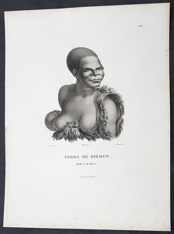
1807 Nicolas Baudin & N M Petit Antique Print of Tasmanian Aboriginal Arra Maida
- Title : Terre De Diemen Arra Maida
- Size: 13in x 10in (330mm x 255mm)
- Condition: (A+) Fine Condition
- Date : 1807
- Ref #: 93085
Description:
This exquisite, rare original copper-plate engraved antique print of Tasmanian Aboriginal Arra Maida, visited by the Baudin Expedition to Australia in Feb. 1802, was engraved by Barthélemy Roger, after Nicolas-Martin Petit (the offical artist on the ship Géographe) and was published by Francois Peron (1775 - 1810) in the 1st edition atlas of Nicolas Thomas Baudins expedition to Australia Voyage de découvertes aux Terres Australes
Nicholas Martin Petit sailed with Nicolas Baudin on the expedition of the Géographe and the Naturaliste in late 1800. The scientific field of anthropology was in its infancy – the French had founded the Society of the Observers of Man in 1799. Having embarked as a fourth-class gunner’s mate, Petit, who had had some graphic arts training, became one of the expeditions two illustrators when the official artists quit. From June to November 1802, the expedition was delayed in Sydney while its two ships were repaired. During this time Petit completed portraits of people of the Cadigal, Dharawal, Gweagal, Kurringai and Darug language groups of the Sydney Harbour region. While the sitters names appear to be noted on the works, it is possible that the inscriptions merely reflect French misinterpretation of the Aborigines communications with them.
The portrait of Nourou-gal-derri is pictured advancing for battle.
General Definitions:
Paper thickness and quality: - Heavy and stable
Paper color : - off white
Age of map color: -
Colors used: -
General color appearance: -
Paper size: - 14in x 10in (355mm x 255mm)
Plate size: - 14in x 10in (355mm x 255mm)
Margins: - Min 1/2in (12mm)
Imperfections:
Margins: - None
Plate area: - None
Verso: - None
Background:
The Baudin Expedition of 1800 to 1803 was a French expedition to map the coast of New Holland, Australia. The expedition started with two ships, Géographe, captained by Baudin, and Naturaliste captained by Jacques Hamelin, and was accompanied by nine zoologists and botanists, including Jean-Baptiste Leschenault de la Tour, François Péron and Charles-Alexandre Lesueur as well as the geographer Pierre Faure.
The Baudin expedition departed Le Havre, France, on 19 October 1800. Because of delays in receiving his instructions and problems encountered in Isle de France (now Mauritius) they did not reach Cape Leeuwin on the south-west corner of Australia until May 1801. Upon rounding Cape Naturaliste, they entered Geographe Bay. They then sailed north, but the ships became separated and did not meet again until they reached Timor. On their journeys the Géographe and the Naturaliste surveyed large stretches of the north-western coast. The expedition was severely affected by dysentery and fever, but sailed from Timor on 13 November 1801, back down the north-west and west coast, then across the Great Australian Bight, reaching Tasmania on 13 January 1802. They charted the whole length of Tasmanias east coast and there were extensive interactions with the Indigenous Tasmanians, with whom they had peaceful relationships. They notably produced precious ethnological studies of Indigenous Tasmanians.
The expedition then began surveying the south coast of Australia, but then Captain Jacques Felix Emmanuel Hamelin in Naturaliste decided to make for Port Jackson (Sydney) as he was running short of food and water, and in need of anchors. En route, in April 1802, Hamelin explored the area of Western Port, Victoria, and gave names to places, a number of which have survived, for example, Ile des Français is now called French Island.
Meanwhile, Baudin in the Géographe continued westward, and in April 1802 encountered the British ship Investigator commanded by Matthew Flinders, also engaged in charting the coastline, at Encounter Bay in what is now South Australia. Flinders informed Baudin of his discovery of Kangaroo Island, St. Vincents and Spencers Gulfs. Baudin sailed on to the Nuyts Archipelago, the point reached by t Gulden Zeepaert in 1627 before heading for Port Jackson as well for supplies.
In late 1802 the expedition was at Port Jackson, where the government sold 60 casks of flour and 25 casks of salt meat to Baudin to resupply his two vessels. The supplies permitted Naturaliste to return to France and Géographe to continue her explorations of the Australian coast. Naturaliste took with her the Colonys staff surgeon, Mr. James Thomson, whom Governor Philip Gidley King had given permission to return to England.
Before resuming the voyage Baudin purchased a 30 ton schooner, which he named the Casuarina, a smaller vessel which could conduct close inshore survey work. He sent the larger Naturaliste under Hamelin back to France with all the specimens that had been collected by Baudin and his crew. As the voyage had progressed Louis de Freycinet, now a Lieutenant, had shown his talents as an officer and a hydrographer and so was given command of the Casuarina. The expedition then headed for Tasmania and conducted further charting of Bass Strait before sailing west, following the west coast northward, and after another visit to Timor, undertook further exploration along the north coast of Australia. Plagued by contrary winds, ill health, and because the quadrupeds and emus were very sick, it was decided on 7 July 1803 to return to France. On the return voyage, the ships stopped in Mauritius, where Baudin died of tuberculosis on 16 September 1803. The expedition finally reached France on 24 March 1804.
The scientific expedition was considered a great success, with more than 2500 new species discovered.
Nicolas-Martin Petit 1777 – 1804
Nicholas-Martin Petit was born in Paris, the son of a fan maker, and learned graphic art in the studio of Jacques Louis David. He avoided conscription into Napoleons armies, but wanting to travel, signed up with post Captain Nicholas Baudin on a voyage to the antipodes sponsored by the French government. Petit and fellow artist Charles-Alexandre Lesueur were enlisted directly by Baudin (as 4th class gunners mates) while the two official artists were hired by the organisers of the expedition. Baudin set off in two lavishly equipped vessels, the Géographe and the Naturaliste on 19 October 1800. By the time the expedition reached Mauritius the official artists had quit. Petit and Lesueur took over their duties, but as neither was trained in scientific method or presentation, the value of their work was primarily aesthetic. The French were at this time developing a new scientific field - anthropology. The Society of the Observers of Man was founded in 1799 for this purpose. The study of Man formed part of the background for Petits sensitive drawings and paintings of the indigenous people of Van Diemens Land, Port Jackson and Western Australia. Lesueur focused on the depiction of animals. The expedition charted the coast of Western Australia and Van Diemens land but was plagued by scurvy. On 20 June 1802 the two ships limped into Port Jackson and stayed for five months to refit, during which time Petit completed a number of portraits of Sydney Indigenous people, including the two images of the Eora men, Cour-rou-bari-gal and Y-erren-gou-la-ga. Petit eventually returned to France in 1804. However, before he was well enough to complete the drawings from the expedition he was hurt in a street accident, and he died at the age of 28. Petits unfinished work was first published in 1807 in the Atlas of the Voyage de découvertes aux terres australes and as discrete prints.
Baudin, Nicolas Thomas 1754 – 1803
Baudin was a French explorer, cartographer, naturalist and hydrographer. Born a commoner in Saint-Martin-de-Ré on the Île de Ré on 17 February 1754 Baudin joined the merchant navy at the age of 15 and the French East India Company at the age of 20.
Baudin then joined the La Marine Royale (French Navy) in 1774 and served in the Caribbean as an officier bleu during the American War of Independence of 1775–1783.
In 1785 Baudin and his brother Alexandre were respectively masters of the St Remy and Caroline, taking Acadian settlers from Nantes to La Nouvelle Orléans. In New Orleans local merchants contracted him to take a cargo of wood, salted meat, cod and flour to Isle de France (now Mauritius), which he did in Josephine (also called Pepita), departing New Orleans on 14 July 1786 and arriving at Isle de France on 27 March 1787. In the course of the voyage, Josephine had called at Cap‑Français in Haiti to make a contract to transport slaves there from Madagascar; while in Haiti he also encountered the Austrian botanist Franz Josef Maerter, who apparently informed him that another Austrian botanist, Franz Boos, was at the Cape of Good Hope awaiting a ship to take him to Mauritius. Josephine called at the Cape and took Boos on board. At Mauritius, Boos chartered Baudin to transport him and the collection of plant specimens he had gathered there and at the Cape back to Europe, which Baudin did, Josephine arriving at Trieste on 18 June 1788. The Imperial government in Vienna was contemplating organizing another natural-history expedition, to which Boos would be appointed, in which two ships would be sent to the Malabar and Coromandel coasts of India, the Persian Gulf, Bengal, Ceylon, Sumatra, Java, Borneo, Cochin China, Tongking, Japan and China. Baudin had been given reason to hope that he would be given command of the ships of this expedition.
Later in 1788 Baudin sailed on a commercial voyage from Trieste to Canton in Jardiniere. He apparently arrived at Canton from Mauritius under the flag of the United States of America, probably to avoid the possibility of having his ship seized by the Chinese for payment of the debts owed them by the Imperial Asiatic Company of Trieste. From there, he sent Jardiniere under her second captain on a fur-trading venture to the north-west coast of America, but the ship foundered off Asuncion Island in the Marianas in late 1789.
Baudin made his way to Mauritius, where he purchased a replacement ship, Jardiniere II, but this vessel was wrecked in a cyclone that struck Port Louis on 15 December 1789. Baudin embarked on the Spanish Royal Philippines Company ship, Placeres, which sailed from Port Louis for Cadiz in August 1790. Placeres called at the Cape of Good Hope where it took on board the large number of plant and animal specimens collected in South Africa for the Imperial palace at Schönbrunn by Georg Scholl, the assistant of Franz Boos. Because of the poor condition of the ship, Placeres had to put in at the island of Trinidad in the West Indies, where Scholls collection of specimens was deposited.
Baudin proceeded to Martinique, from where he addressed an offer to the Imperial government in Vienna to conduct to Canton commissioners who would be empowered to negotiate with the Chinese merchants there a settlement of the debts incurred by the Imperial Asiatic Company, which would enable the company to renew its trade with China. On its return voyage from Canton, the proposed expedition would call at the Cape of Good Hope to pick up Scholl and the remainder of his natural-history collection for conveyance to Schönbrunn.
After returning to Vienna in September 1791, Baudin continued to press his case for an expedition under the Imperial flag to the Indian Ocean and China, and in January 1792 he was granted a commission of captain in the Imperial navy for this purpose. A ship, called Jardiniere, was acquired and the botanists Franz Bredemeyer and Joseph van der Schot appointed to the expedition. After delays caused by the outbreak of war between France and Austria (April 1792), Jardiniere departed from the Spanish port of Málaga on 1 October 1792. From the Cape of Good Hope Jardiniere sailed across the Indian Ocean to the coast of New Holland (Australia), but two consecutive cyclones prevented the expedition from doing any work there and forced Baudin to take the ship to Bombay for repairs.
From Bombay the expedition proceeded to the Persian Gulf, the Red Sea and the east coast of Africa, where it gathered botanical and zoological collections. The expedition came to an abrupt end in June 1794 when Jardiniere went aground in a storm while attempting to enter Table Bay at the Cape of Good Hope. Baudin survived the wreck and made his way to the United States, from where he went to France. He managed to send Jardinieres cargo of natural history specimens to the island of Trinidad.
In Paris, Baudin visited Antoine de Jussieu at the Museum National dHistoire Naturelle in March 1796 to suggest a botanical voyage to the Caribbean, during which he would recover the collection of specimens he had left in Trinidad. The Museum and the French government accepted the proposal, and Baudin was appointed commander of an expedition in the ship Belle Angélique, with four assigned botanists: René Maugé, André Pierre Ledru, Anselme Riedlé and Stanislas Levillain. Belle Angélique cleared Le Havre on 30 September 1796 for the Canary Islands, where the ship was condemned as unseaworthy. The expedition sailed from the Canaries in a replacement vessel, Fanny, and reached Trinidad in April 1797. The British, who had just captured the island from the Spanish in February 1797, refused to allow Baudin to recover the collection of natural-history specimens. Baudin took Fanny to St. Thomas and St. Croix, and then to Puerto Rico, specimens being collected in all three islands. At St Croix, Fanny was replaced by a newly purchased ship, renamed Belle Angelique. The expedition returned to France in June 1798 with a large collection of plants, birds and insects, which was incorporated into Napoleon Bonapartes triumphal procession celebrating his recent Italian victories.
On 24 July 1798, at the suggestion of the Ministry of Marine, Baudin presented to the Assembly of Professors and Administrators of the National Museum of Natural History a plan for a hydrographic-survey expedition to the South Seas, which would include a search for fauna and flora that could be brought back for cultivation in France. The expedition would also have the aim of promoting the economic and commercial interests of France in the regions to be visited. The expedition would require two well-equipped ships, which would carry a team of astronomers, naturalists and scientific draughtsmen over whom Baudin as commander would have absolute authority. The first part of the voyage would be devoted to a thorough exploration of the coast of Chile and the collection of animal, bird and plant specimens suitable for acclimatization in France, followed by a survey of the coasts from Peru to Mexico. The expedition would then continue into the Pacific Ocean, including a visit to Tahiti and the Society Islands, and would be completed with a survey of the yet unexplored south-west coast of New Holland (Australia). After considering this extensive proposal, the French government decided to proceed with an expedition confined to a survey of western and southern New Holland (as Australia was called at the time).
In October 1800 Baudin was selected to lead what has become known as the Baudin expedition to map the coast of Australia (New Holland). He had two ships, Géographe and Naturaliste captained by Hamelin, and a suite of nine zoologists and botanists, including Jean Baptiste Leschenault de la Tour. He reached Australia in May 1801, and would explore and map the western coast and a part of the little-known southern coast of the continent. The scientific expedition proved a great success, with more than 2500 new species discovered. The French also met Aboriginal peoples and treated them with great respect.
In April 1802 Baudin met Matthew Flinders, also engaged in charting the coastline, in Encounter Bay in present-day South Australia. Baudin then stopped at the British colony at Sydney for supplies. In Sydney he bought a new ship — Casuarina — named after the wood it was made from. From there he sent home Naturaliste, which had on board all of the specimens that had been discovered by Baudin and his crew. He then headed for Tasmania, before continuing north to Timor. Baudin then sailed for home, stopping at Mauritius.
According to recent researches by academics from the University of Adelaide, during Baudins expedition, François Péron, who had become the chief zoologist and intellectual leader of the mission, wrote a report for Napoleon on ways to invade and capture the British colony at Sydney Cove.
Baudin died of tuberculosis at Mauritius on 16 September 1803, at the age of 49, apparently in the home of Madame Alexandrine Kerivel. Baudins exact resting place is not known, but the historian Auguste Toussaint believed that he was interred in the Kerivel family vault. However, the historian Edward Duyker likes to think that Baudin was buried in Le Cimetière de lOuest in the district of Port Louis just a few hundred metres from the explorers certain love: the sea.
Please note all items auctioned are genuine, we do not sell reproductions. A Certificate of Authenticity (COA) can be issued on request.
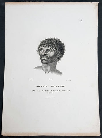
1807 Baudin & Petit Antique Print Sydney Aboriginal Gnung-a Gnung-a Murremurgan - Bennelong
- Title : Nouvelle-Hollande. Gnoung-a-gnoung-a Mour-re-mour-ga (dit Collins)
- Size: 14in x 10in (355mm x 255mm)
- Condition: (A+) Fine Condition
- Date : 1807
- Ref #: 91239
Description:
This exquisite, rare original copper-plate engraved antique print, of the brother in law of the famous Port Jackson Aborginal leader Bennelong, Gnung-a Gnung-a Murremurgan, or Anganángan, was engraved by Barthélemy Roger, after the 1802 by Nicolas-Martin Petit, was published by Francois Peron (1775 - 1810) in the 1st edition atlas of Nicolas Thomas Baudins expedition to Australia Voyage de découvertes aux Terres Australes
Gnung-a Gnung-a Murremurgan
It is over 200 years since the death of an adventurous young Aboriginal Australian who crossed the vast Pacific Ocean to North America and returned to Sydney. From the deck of an English storeship he glimpsed many strange places, visiting Norfolk Island, Hawaii, Nootka Sound (now Vancouver, Canada) and the Spanish colonies of San Francisco, Santa Barbara and San Diego on the Californian coast.
The voyager was Gnung-a Gnung-a Murremurgan, whose wife Warreeweer was the younger sister of the Wangal leader Woollarawarre Bennelong, at that time being feted in London society. The distance Gnung-a Gnung-a traversed was some 16,000 miles (25,750 kilometres) as the crow flies, but much further in a sailing ship driven by unpredictable winds.
On the first day he ventured into the convict settlement at Sydney Cove, in November 1790, Gnung-a Gnung-a adopted the name Collins from Acting Judge Advocate David Collins, who often mentions him in An Account of the English Colony in New South Wales, published in London in 1798.
It was the idea of Major Francis Grose, acting governor of New South Wales after the departure of Captain Arthur Phillip in 1792, to embark a native of this country on HM storeship Daedalus for the purpose of acquiring our language, wrote David Collins. The 350-ton capacity vessel was ordered to resupply provisions for the expedition to the north-west coast of North America commanded by Captain George Vancouver (1757–1798). In the navy ships HMS Discovery and HMS Chatham, Captain Vancouver was to complete the survey made by Captain James Cook.
Voyage to America
HMS Daedalus sailed from Port Jackson on 1 July 1793, passing west of the Society Islands (French Polynesia) to Owhyee (Hawaii). The commander, Lieutenant James Hanson, missed a rendezvous with Vancouvers ships at Nootka Sound on 8 October, but anchored with the two survey ships off San Francisco Bay on 21 October. The three British ships followed the coast of todays California to San Diego, leaving on 9 December 1793 and arriving at Hilo in Hawaii on 8 January 1794.
The Hawaiian King Kamehameha, who warmly welcomed Vancouver, was so impressed by the good-natured, handsome Aboriginal man on the expedition that he wanted to buy him, offering in exchange canoes, weapons and curiosities.
Gnung-a Gnung-a got on well with everyone on Daedalus and Hanson was pleased by his good nature and his willingness to do whatever was asked of him. During his month in Hawaii, he often went ashore with his shipmates. Wherever he went he readily adopted the manners of those around him, Hanson later told Collins, who remarked, with ironic humour, that...........
when at Owhyee, having discovered that favours from the females were to be procured at the easy exchange for a looking-glass, a nail, or a knife, he was not backward in presenting his little offering, and was as well received as any of the white people in the ship. It was noticed too that he always displayed some taste in selecting the object of his attentions.......
Return to Sydney
Home in Sydney Town, Gnung-a Gnung-a fought and wounded a very fine young fellow called Wyatt, who had taken up with his wife during his absence and Warreeweer became the prize of the victor.
During a ritual revenge combat in December 1795, Pemulwuy, leader of the Georges River Bidjigal near Botany Bay, launched a spear at Gnung-a Gnung-a that remained fixed in his back. The English surgeons could not extract the spear and thought he was unlikely to recover. Gnung-a Gnung-a, however, left the hospital and walked about for several weeks with the spear protruding from his back. At last, wrote Collins in a footnote..........
we heard that his wife, or one of his male friends, had fixed their teeth in the wood and drawn it out after which he recovered, and was able again to go into the field. His wife War-re-weer showed by an uncommon attention her great attachment to him.......
Before this unexpected recovery, David Collins wrote a brief appreciation of his namesake:
He was much esteemed by every white man who knew him, as well on account of his personal bravery, of which we had witnessed many distinguishing proofs, as on account of a gentleness of manners which strongly marked his disposition, and shaded off the harsher lines that his uncivilised life now and then forced into the fore-ground.
While in Sydney with a scientific expedition commanded by Nicholas Baudin in 1802, the young French artist Nicolas-Martin Petit met Gnung-a Gnung-a and sketched a striking portrait that he captioned Gnoung-a gnoung-a, mour-re-mour-ga (dit Collins)
A report in the Sydney Gazette of Sunday 15 January 1809 said that the body of Collins (Gnung-a Gnung-a Murremurgan) had been found beside the Dry Store, site of the present Sirius Park in Bridge Street, Sydney. The newspaper said he had been known for the docility of his temper, and the high estimation in which he was universally held among the native tribes.
On the night of Thursday 12 January 1809, Gnung-a Gnung-as children, others he had adopted, and his brother Old Phillip, faced a salvo of spears in the ritual ordeal that followed death in Aboriginal society. The date of his death was not recorded, but it was customary to keep an overnight vigil over a dead body before burial and the subsequent revenge combat, so it was probably 11 January.
Gnung-a Gnung-a Murremurgan is one of many Aboriginal men and women who sailed from Sydney in English ships and played a significant role in Australias early maritime history.
General Definitions:
Paper thickness and quality: - Heavy and stable
Paper color : - off white
Age of map color: -
Colors used: -
General color appearance: -
Paper size: - 14in x 10in (355mm x 255mm)
Plate size: - 12 1/2in x 9 1/2in (320mm x 240mm)
Margins: - Min 1/2in (12mm)
Imperfections:
Margins: - Light age toning to outer margins
Plate area: - None
Verso: - None
Background:
The Baudin Expedition of 1800 to 1803 was a French expedition to map the coast of New Holland, Australia. The expedition started with two ships, Géographe, captained by Baudin, and Naturaliste captained by Jacques Hamelin, and was accompanied by nine zoologists and botanists, including Jean-Baptiste Leschenault de la Tour, François Péron and Charles-Alexandre Lesueur as well as the geographer Pierre Faure.
The Baudin expedition departed Le Havre, France, on 19 October 1800. Because of delays in receiving his instructions and problems encountered in Isle de France (now Mauritius) they did not reach Cape Leeuwin on the south-west corner of Australia until May 1801. Upon rounding Cape Naturaliste, they entered Geographe Bay. They then sailed north, but the ships became separated and did not meet again until they reached Timor. On their journeys the Géographe and the Naturaliste surveyed large stretches of the north-western coast. The expedition was severely affected by dysentery and fever, but sailed from Timor on 13 November 1801, back down the north-west and west coast, then across the Great Australian Bight, reaching Tasmania on 13 January 1802. They charted the whole length of Tasmanias east coast and there were extensive interactions with the Indigenous Tasmanians, with whom they had peaceful relationships. They notably produced precious ethnological studies of Indigenous Tasmanians.
The expedition then began surveying the south coast of Australia, but then Captain Jacques Felix Emmanuel Hamelin in Naturaliste decided to make for Port Jackson (Sydney) as he was running short of food and water, and in need of anchors. En route, in April 1802, Hamelin explored the area of Western Port, Victoria, and gave names to places, a number of which have survived, for example, Ile des Français is now called French Island.
Meanwhile, Baudin in the Géographe continued westward, and in April 1802 encountered the British ship Investigator commanded by Matthew Flinders, also engaged in charting the coastline, at Encounter Bay in what is now South Australia. Flinders informed Baudin of his discovery of Kangaroo Island, St. Vincents and Spencers Gulfs. Baudin sailed on to the Nuyts Archipelago, the point reached by t Gulden Zeepaert in 1627 before heading for Port Jackson as well for supplies.
In late 1802 the expedition was at Port Jackson, where the government sold 60 casks of flour and 25 casks of salt meat to Baudin to resupply his two vessels. The supplies permitted Naturaliste to return to France and Géographe to continue her explorations of the Australian coast. Naturaliste took with her the Colonys staff surgeon, Mr. James Thomson, whom Governor Philip Gidley King had given permission to return to England.
Before resuming the voyage Baudin purchased a 30 ton schooner, which he named the Casuarina, a smaller vessel which could conduct close inshore survey work. He sent the larger Naturaliste under Hamelin back to France with all the specimens that had been collected by Baudin and his crew. As the voyage had progressed Louis de Freycinet, now a Lieutenant, had shown his talents as an officer and a hydrographer and so was given command of the Casuarina. The expedition then headed for Tasmania and conducted further charting of Bass Strait before sailing west, following the west coast northward, and after another visit to Timor, undertook further exploration along the north coast of Australia. Plagued by contrary winds, ill health, and because the quadrupeds and emus were very sick, it was decided on 7 July 1803 to return to France. On the return voyage, the ships stopped in Mauritius, where Baudin died of tuberculosis on 16 September 1803. The expedition finally reached France on 24 March 1804.
The scientific expedition was considered a great success, with more than 2500 new species discovered.
Nicolas-Martin Petit 1777 – 1804
Nicholas-Martin Petit was born in Paris, the son of a fan maker, and learned graphic art in the studio of Jacques Louis David. He avoided conscription into Napoleons armies, but wanting to travel, signed up with post Captain Nicholas Baudin on a voyage to the antipodes sponsored by the French government. Petit and fellow artist Charles-Alexandre Lesueur were enlisted directly by Baudin (as 4th class gunners mates) while the two official artists were hired by the organisers of the expedition. Baudin set off in two lavishly equipped vessels, the Géographe and the Naturaliste on 19 October 1800. By the time the expedition reached Mauritius the official artists had quit. Petit and Lesueur took over their duties, but as neither was trained in scientific method or presentation, the value of their work was primarily aesthetic. The French were at this time developing a new scientific field - anthropology. The Society of the Observers of Man was founded in 1799 for this purpose. The study of Man formed part of the background for Petits sensitive drawings and paintings of the indigenous people of Van Diemens Land, Port Jackson and Western Australia. Lesueur focused on the depiction of animals. The expedition charted the coast of Western Australia and Van Diemens land but was plagued by scurvy. On 20 June 1802 the two ships limped into Port Jackson and stayed for five months to refit, during which time Petit completed a number of portraits of Sydney Indigenous people, including the two images of the Eora men, Cour-rou-bari-gal and Y-erren-gou-la-ga. Petit eventually returned to France in 1804. However, before he was well enough to complete the drawings from the expedition he was hurt in a street accident, and he died at the age of 28. Petits unfinished work was first published in 1807 in the Atlas of the Voyage de découvertes aux terres australes and as discrete prints.
Baudin, Nicolas Thomas 1754 – 1803
Baudin was a French explorer, cartographer, naturalist and hydrographer. Born a commoner in Saint-Martin-de-Ré on the Île de Ré on 17 February 1754 Baudin joined the merchant navy at the age of 15 and the French East India Company at the age of 20.
Baudin then joined the La Marine Royale (French Navy) in 1774 and served in the Caribbean as an officier bleu during the American War of Independence of 1775–1783.
In 1785 Baudin and his brother Alexandre were respectively masters of the St Remy and Caroline, taking Acadian settlers from Nantes to La Nouvelle Orléans. In New Orleans local merchants contracted him to take a cargo of wood, salted meat, cod and flour to Isle de France (now Mauritius), which he did in Josephine (also called Pepita), departing New Orleans on 14 July 1786 and arriving at Isle de France on 27 March 1787. In the course of the voyage, Josephine had called at Cap‑Français in Haiti to make a contract to transport slaves there from Madagascar; while in Haiti he also encountered the Austrian botanist Franz Josef Maerter, who apparently informed him that another Austrian botanist, Franz Boos, was at the Cape of Good Hope awaiting a ship to take him to Mauritius. Josephine called at the Cape and took Boos on board. At Mauritius, Boos chartered Baudin to transport him and the collection of plant specimens he had gathered there and at the Cape back to Europe, which Baudin did, Josephine arriving at Trieste on 18 June 1788. The Imperial government in Vienna was contemplating organizing another natural-history expedition, to which Boos would be appointed, in which two ships would be sent to the Malabar and Coromandel coasts of India, the Persian Gulf, Bengal, Ceylon, Sumatra, Java, Borneo, Cochin China, Tongking, Japan and China. Baudin had been given reason to hope that he would be given command of the ships of this expedition.
Later in 1788 Baudin sailed on a commercial voyage from Trieste to Canton in Jardiniere. He apparently arrived at Canton from Mauritius under the flag of the United States of America, probably to avoid the possibility of having his ship seized by the Chinese for payment of the debts owed them by the Imperial Asiatic Company of Trieste. From there, he sent Jardiniere under her second captain on a fur-trading venture to the north-west coast of America, but the ship foundered off Asuncion Island in the Marianas in late 1789.
Baudin made his way to Mauritius, where he purchased a replacement ship, Jardiniere II, but this vessel was wrecked in a cyclone that struck Port Louis on 15 December 1789. Baudin embarked on the Spanish Royal Philippines Company ship, Placeres, which sailed from Port Louis for Cadiz in August 1790. Placeres called at the Cape of Good Hope where it took on board the large number of plant and animal specimens collected in South Africa for the Imperial palace at Schönbrunn by Georg Scholl, the assistant of Franz Boos. Because of the poor condition of the ship, Placeres had to put in at the island of Trinidad in the West Indies, where Scholls collection of specimens was deposited.
Baudin proceeded to Martinique, from where he addressed an offer to the Imperial government in Vienna to conduct to Canton commissioners who would be empowered to negotiate with the Chinese merchants there a settlement of the debts incurred by the Imperial Asiatic Company, which would enable the company to renew its trade with China. On its return voyage from Canton, the proposed expedition would call at the Cape of Good Hope to pick up Scholl and the remainder of his natural-history collection for conveyance to Schönbrunn.
After returning to Vienna in September 1791, Baudin continued to press his case for an expedition under the Imperial flag to the Indian Ocean and China, and in January 1792 he was granted a commission of captain in the Imperial navy for this purpose. A ship, called Jardiniere, was acquired and the botanists Franz Bredemeyer and Joseph van der Schot appointed to the expedition. After delays caused by the outbreak of war between France and Austria (April 1792), Jardiniere departed from the Spanish port of Málaga on 1 October 1792. From the Cape of Good Hope Jardiniere sailed across the Indian Ocean to the coast of New Holland (Australia), but two consecutive cyclones prevented the expedition from doing any work there and forced Baudin to take the ship to Bombay for repairs.
From Bombay the expedition proceeded to the Persian Gulf, the Red Sea and the east coast of Africa, where it gathered botanical and zoological collections. The expedition came to an abrupt end in June 1794 when Jardiniere went aground in a storm while attempting to enter Table Bay at the Cape of Good Hope. Baudin survived the wreck and made his way to the United States, from where he went to France. He managed to send Jardinieres cargo of natural history specimens to the island of Trinidad.
In Paris, Baudin visited Antoine de Jussieu at the Museum National dHistoire Naturelle in March 1796 to suggest a botanical voyage to the Caribbean, during which he would recover the collection of specimens he had left in Trinidad. The Museum and the French government accepted the proposal, and Baudin was appointed commander of an expedition in the ship Belle Angélique, with four assigned botanists: René Maugé, André Pierre Ledru, Anselme Riedlé and Stanislas Levillain. Belle Angélique cleared Le Havre on 30 September 1796 for the Canary Islands, where the ship was condemned as unseaworthy. The expedition sailed from the Canaries in a replacement vessel, Fanny, and reached Trinidad in April 1797. The British, who had just captured the island from the Spanish in February 1797, refused to allow Baudin to recover the collection of natural-history specimens. Baudin took Fanny to St. Thomas and St. Croix, and then to Puerto Rico, specimens being collected in all three islands. At St Croix, Fanny was replaced by a newly purchased ship, renamed Belle Angelique. The expedition returned to France in June 1798 with a large collection of plants, birds and insects, which was incorporated into Napoleon Bonapartes triumphal procession celebrating his recent Italian victories.
On 24 July 1798, at the suggestion of the Ministry of Marine, Baudin presented to the Assembly of Professors and Administrators of the National Museum of Natural History a plan for a hydrographic-survey expedition to the South Seas, which would include a search for fauna and flora that could be brought back for cultivation in France. The expedition would also have the aim of promoting the economic and commercial interests of France in the regions to be visited. The expedition would require two well-equipped ships, which would carry a team of astronomers, naturalists and scientific draughtsmen over whom Baudin as commander would have absolute authority. The first part of the voyage would be devoted to a thorough exploration of the coast of Chile and the collection of animal, bird and plant specimens suitable for acclimatization in France, followed by a survey of the coasts from Peru to Mexico. The expedition would then continue into the Pacific Ocean, including a visit to Tahiti and the Society Islands, and would be completed with a survey of the yet unexplored south-west coast of New Holland (Australia). After considering this extensive proposal, the French government decided to proceed with an expedition confined to a survey of western and southern New Holland (as Australia was called at the time).
In October 1800 Baudin was selected to lead what has become known as the Baudin expedition to map the coast of Australia (New Holland). He had two ships, Géographe and Naturaliste captained by Hamelin, and a suite of nine zoologists and botanists, including Jean Baptiste Leschenault de la Tour. He reached Australia in May 1801, and would explore and map the western coast and a part of the little-known southern coast of the continent. The scientific expedition proved a great success, with more than 2500 new species discovered. The French also met Aboriginal peoples and treated them with great respect.
In April 1802 Baudin met Matthew Flinders, also engaged in charting the coastline, in Encounter Bay in present-day South Australia. Baudin then stopped at the British colony at Sydney for supplies. In Sydney he bought a new ship — Casuarina — named after the wood it was made from. From there he sent home Naturaliste, which had on board all of the specimens that had been discovered by Baudin and his crew. He then headed for Tasmania, before continuing north to Timor. Baudin then sailed for home, stopping at Mauritius.
According to recent researches by academics from the University of Adelaide, during Baudins expedition, François Péron, who had become the chief zoologist and intellectual leader of the mission, wrote a report for Napoleon on ways to invade and capture the British colony at Sydney Cove.
Baudin died of tuberculosis at Mauritius on 16 September 1803, at the age of 49, apparently in the home of Madame Alexandrine Kerivel. Baudins exact resting place is not known, but the historian Auguste Toussaint believed that he was interred in the Kerivel family vault. However, the historian Edward Duyker likes to think that Baudin was buried in Le Cimetière de lOuest in the district of Port Louis just a few hundred metres from the explorers certain love: the sea.
Please note all items auctioned are genuine, we do not sell reproductions. A Certificate of Authenticity (COA) can be issued on request.
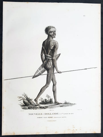
1807 Baudin & Petit Antique Print of a Sydney & Port Jackson Aboriginal Warrior
- Title : Nouvelle-Hollande. Nelle Galles Du Sud. Nourou-gal-derri & avancant pour combattre
- Size: 13in x 10in (330mm x 255mm)
- Condition: (A+) Fine Condition
- Date : 1807
- Ref #: 93087
Description:
This exquisite, rare original copper-plate engraved antique print of an Aboriginal warrior of Port Jackson carrying a spear & shield, was engraved by Barthélemy Roger, after the 1802 drawing by Nicolas-Martin Petit and was published by Francois Peron (1775 - 1810) in the 1st edition atlas of Nicolas Thomas Baudins expedition to Australia Voyage de découvertes aux Terres Australes in 1807.
This is a wonderful original stipple point engraving by Petit & Roger bringing to life this wonderful 1st Australian.
Nicholas Martin Petit sailed with Nicolas Baudin on the expedition of the Géographe and the Naturaliste in late 1800. The scientific field of anthropology was in its infancy – the French had founded the Society of the Observers of Man in 1799. Having embarked as a fourth-class gunner’s mate, Petit, who had had some graphic arts training, became one of the expeditions two illustrators when the official artists quit. From June to November 1802, the expedition was delayed in Sydney while its two ships were repaired. During this time Petit completed portraits of people of the Cadigal, Dharawal, Gweagal, Kurringai and Darug language groups of the Sydney Harbour region. While the sitters names appear to be noted on the works, it is possible that the inscriptions merely reflect French misinterpretation of the Aborigines communications with them.
The portrait of Nourou-gal-derri is pictured advancing for battle.
General Definitions:
Paper thickness and quality: - Heavy and stable
Paper color : - off white
Age of map color: -
Colors used: -
General color appearance: -
Paper size: - 13in x 10in (330mm x 255mm)
Plate size: - 13in x 10in (330mm x 255mm)
Margins: - Min 1/2in (12mm)
Imperfections:
Margins: - Light spotting to left and bottom margins, not affecting the image
Plate area: - None
Verso: - None
Background:
The Baudin Expedition of 1800 to 1803 was a French expedition to map the coast of New Holland, Australia. The expedition started with two ships, Géographe, captained by Baudin, and Naturaliste captained by Jacques Hamelin, and was accompanied by nine zoologists and botanists, including Jean-Baptiste Leschenault de la Tour, François Péron and Charles-Alexandre Lesueur as well as the geographer Pierre Faure.
The Baudin expedition departed Le Havre, France, on 19 October 1800. Because of delays in receiving his instructions and problems encountered in Isle de France (now Mauritius) they did not reach Cape Leeuwin on the south-west corner of Australia until May 1801. Upon rounding Cape Naturaliste, they entered Geographe Bay. They then sailed north, but the ships became separated and did not meet again until they reached Timor. On their journeys the Géographe and the Naturaliste surveyed large stretches of the north-western coast. The expedition was severely affected by dysentery and fever, but sailed from Timor on 13 November 1801, back down the north-west and west coast, then across the Great Australian Bight, reaching Tasmania on 13 January 1802. They charted the whole length of Tasmanias east coast and there were extensive interactions with the Indigenous Tasmanians, with whom they had peaceful relationships. They notably produced precious ethnological studies of Indigenous Tasmanians.
The expedition then began surveying the south coast of Australia, but then Captain Jacques Felix Emmanuel Hamelin in Naturaliste decided to make for Port Jackson (Sydney) as he was running short of food and water, and in need of anchors. En route, in April 1802, Hamelin explored the area of Western Port, Victoria, and gave names to places, a number of which have survived, for example, Ile des Français is now called French Island.
Meanwhile, Baudin in the Géographe continued westward, and in April 1802 encountered the British ship Investigator commanded by Matthew Flinders, also engaged in charting the coastline, at Encounter Bay in what is now South Australia. Flinders informed Baudin of his discovery of Kangaroo Island, St. Vincents and Spencers Gulfs. Baudin sailed on to the Nuyts Archipelago, the point reached by t Gulden Zeepaert in 1627 before heading for Port Jackson as well for supplies.
In late 1802 the expedition was at Port Jackson, where the government sold 60 casks of flour and 25 casks of salt meat to Baudin to resupply his two vessels. The supplies permitted Naturaliste to return to France and Géographe to continue her explorations of the Australian coast. Naturaliste took with her the Colonys staff surgeon, Mr. James Thomson, whom Governor Philip Gidley King had given permission to return to England.
Before resuming the voyage Baudin purchased a 30 ton schooner, which he named the Casuarina, a smaller vessel which could conduct close inshore survey work. He sent the larger Naturaliste under Hamelin back to France with all the specimens that had been collected by Baudin and his crew. As the voyage had progressed Louis de Freycinet, now a Lieutenant, had shown his talents as an officer and a hydrographer and so was given command of the Casuarina. The expedition then headed for Tasmania and conducted further charting of Bass Strait before sailing west, following the west coast northward, and after another visit to Timor, undertook further exploration along the north coast of Australia. Plagued by contrary winds, ill health, and because the quadrupeds and emus were very sick, it was decided on 7 July 1803 to return to France. On the return voyage, the ships stopped in Mauritius, where Baudin died of tuberculosis on 16 September 1803. The expedition finally reached France on 24 March 1804.
The scientific expedition was considered a great success, with more than 2500 new species discovered.
Nicolas-Martin Petit 1777 – 1804
Nicholas-Martin Petit was born in Paris, the son of a fan maker, and learned graphic art in the studio of Jacques Louis David. He avoided conscription into Napoleons armies, but wanting to travel, signed up with post Captain Nicholas Baudin on a voyage to the antipodes sponsored by the French government. Petit and fellow artist Charles-Alexandre Lesueur were enlisted directly by Baudin (as 4th class gunners mates) while the two official artists were hired by the organisers of the expedition. Baudin set off in two lavishly equipped vessels, the Géographe and the Naturaliste on 19 October 1800. By the time the expedition reached Mauritius the official artists had quit. Petit and Lesueur took over their duties, but as neither was trained in scientific method or presentation, the value of their work was primarily aesthetic. The French were at this time developing a new scientific field - anthropology. The Society of the Observers of Man was founded in 1799 for this purpose. The study of Man formed part of the background for Petits sensitive drawings and paintings of the indigenous people of Van Diemens Land, Port Jackson and Western Australia. Lesueur focused on the depiction of animals. The expedition charted the coast of Western Australia and Van Diemens land but was plagued by scurvy. On 20 June 1802 the two ships limped into Port Jackson and stayed for five months to refit, during which time Petit completed a number of portraits of Sydney Indigenous people, including the two images of the Eora men, Cour-rou-bari-gal and Y-erren-gou-la-ga. Petit eventually returned to France in 1804. However, before he was well enough to complete the drawings from the expedition he was hurt in a street accident, and he died at the age of 28. Petits unfinished work was first published in 1807 in the Atlas of the Voyage de découvertes aux terres australes and as discrete prints.
Baudin, Nicolas Thomas 1754 – 1803
Baudin was a French explorer, cartographer, naturalist and hydrographer. Born a commoner in Saint-Martin-de-Ré on the Île de Ré on 17 February 1754 Baudin joined the merchant navy at the age of 15 and the French East India Company at the age of 20.
Baudin then joined the La Marine Royale (French Navy) in 1774 and served in the Caribbean as an officier bleu during the American War of Independence of 1775–1783.
In 1785 Baudin and his brother Alexandre were respectively masters of the St Remy and Caroline, taking Acadian settlers from Nantes to La Nouvelle Orléans. In New Orleans local merchants contracted him to take a cargo of wood, salted meat, cod and flour to Isle de France (now Mauritius), which he did in Josephine (also called Pepita), departing New Orleans on 14 July 1786 and arriving at Isle de France on 27 March 1787. In the course of the voyage, Josephine had called at Cap‑Français in Haiti to make a contract to transport slaves there from Madagascar; while in Haiti he also encountered the Austrian botanist Franz Josef Maerter, who apparently informed him that another Austrian botanist, Franz Boos, was at the Cape of Good Hope awaiting a ship to take him to Mauritius. Josephine called at the Cape and took Boos on board. At Mauritius, Boos chartered Baudin to transport him and the collection of plant specimens he had gathered there and at the Cape back to Europe, which Baudin did, Josephine arriving at Trieste on 18 June 1788. The Imperial government in Vienna was contemplating organizing another natural-history expedition, to which Boos would be appointed, in which two ships would be sent to the Malabar and Coromandel coasts of India, the Persian Gulf, Bengal, Ceylon, Sumatra, Java, Borneo, Cochin China, Tongking, Japan and China. Baudin had been given reason to hope that he would be given command of the ships of this expedition.
Later in 1788 Baudin sailed on a commercial voyage from Trieste to Canton in Jardiniere. He apparently arrived at Canton from Mauritius under the flag of the United States of America, probably to avoid the possibility of having his ship seized by the Chinese for payment of the debts owed them by the Imperial Asiatic Company of Trieste. From there, he sent Jardiniere under her second captain on a fur-trading venture to the north-west coast of America, but the ship foundered off Asuncion Island in the Marianas in late 1789.
Baudin made his way to Mauritius, where he purchased a replacement ship, Jardiniere II, but this vessel was wrecked in a cyclone that struck Port Louis on 15 December 1789. Baudin embarked on the Spanish Royal Philippines Company ship, Placeres, which sailed from Port Louis for Cadiz in August 1790. Placeres called at the Cape of Good Hope where it took on board the large number of plant and animal specimens collected in South Africa for the Imperial palace at Schönbrunn by Georg Scholl, the assistant of Franz Boos. Because of the poor condition of the ship, Placeres had to put in at the island of Trinidad in the West Indies, where Scholls collection of specimens was deposited.
Baudin proceeded to Martinique, from where he addressed an offer to the Imperial government in Vienna to conduct to Canton commissioners who would be empowered to negotiate with the Chinese merchants there a settlement of the debts incurred by the Imperial Asiatic Company, which would enable the company to renew its trade with China. On its return voyage from Canton, the proposed expedition would call at the Cape of Good Hope to pick up Scholl and the remainder of his natural-history collection for conveyance to Schönbrunn.
After returning to Vienna in September 1791, Baudin continued to press his case for an expedition under the Imperial flag to the Indian Ocean and China, and in January 1792 he was granted a commission of captain in the Imperial navy for this purpose. A ship, called Jardiniere, was acquired and the botanists Franz Bredemeyer and Joseph van der Schot appointed to the expedition. After delays caused by the outbreak of war between France and Austria (April 1792), Jardiniere departed from the Spanish port of Málaga on 1 October 1792. From the Cape of Good Hope Jardiniere sailed across the Indian Ocean to the coast of New Holland (Australia), but two consecutive cyclones prevented the expedition from doing any work there and forced Baudin to take the ship to Bombay for repairs.
From Bombay the expedition proceeded to the Persian Gulf, the Red Sea and the east coast of Africa, where it gathered botanical and zoological collections. The expedition came to an abrupt end in June 1794 when Jardiniere went aground in a storm while attempting to enter Table Bay at the Cape of Good Hope. Baudin survived the wreck and made his way to the United States, from where he went to France. He managed to send Jardinieres cargo of natural history specimens to the island of Trinidad.
In Paris, Baudin visited Antoine de Jussieu at the Museum National dHistoire Naturelle in March 1796 to suggest a botanical voyage to the Caribbean, during which he would recover the collection of specimens he had left in Trinidad. The Museum and the French government accepted the proposal, and Baudin was appointed commander of an expedition in the ship Belle Angélique, with four assigned botanists: René Maugé, André Pierre Ledru, Anselme Riedlé and Stanislas Levillain. Belle Angélique cleared Le Havre on 30 September 1796 for the Canary Islands, where the ship was condemned as unseaworthy. The expedition sailed from the Canaries in a replacement vessel, Fanny, and reached Trinidad in April 1797. The British, who had just captured the island from the Spanish in February 1797, refused to allow Baudin to recover the collection of natural-history specimens. Baudin took Fanny to St. Thomas and St. Croix, and then to Puerto Rico, specimens being collected in all three islands. At St Croix, Fanny was replaced by a newly purchased ship, renamed Belle Angelique. The expedition returned to France in June 1798 with a large collection of plants, birds and insects, which was incorporated into Napoleon Bonapartes triumphal procession celebrating his recent Italian victories.
On 24 July 1798, at the suggestion of the Ministry of Marine, Baudin presented to the Assembly of Professors and Administrators of the National Museum of Natural History a plan for a hydrographic-survey expedition to the South Seas, which would include a search for fauna and flora that could be brought back for cultivation in France. The expedition would also have the aim of promoting the economic and commercial interests of France in the regions to be visited. The expedition would require two well-equipped ships, which would carry a team of astronomers, naturalists and scientific draughtsmen over whom Baudin as commander would have absolute authority. The first part of the voyage would be devoted to a thorough exploration of the coast of Chile and the collection of animal, bird and plant specimens suitable for acclimatization in France, followed by a survey of the coasts from Peru to Mexico. The expedition would then continue into the Pacific Ocean, including a visit to Tahiti and the Society Islands, and would be completed with a survey of the yet unexplored south-west coast of New Holland (Australia). After considering this extensive proposal, the French government decided to proceed with an expedition confined to a survey of western and southern New Holland (as Australia was called at the time).
In October 1800 Baudin was selected to lead what has become known as the Baudin expedition to map the coast of Australia (New Holland). He had two ships, Géographe and Naturaliste captained by Hamelin, and a suite of nine zoologists and botanists, including Jean Baptiste Leschenault de la Tour. He reached Australia in May 1801, and would explore and map the western coast and a part of the little-known southern coast of the continent. The scientific expedition proved a great success, with more than 2500 new species discovered. The French also met Aboriginal peoples and treated them with great respect.
In April 1802 Baudin met Matthew Flinders, also engaged in charting the coastline, in Encounter Bay in present-day South Australia. Baudin then stopped at the British colony at Sydney for supplies. In Sydney he bought a new ship — Casuarina — named after the wood it was made from. From there he sent home Naturaliste, which had on board all of the specimens that had been discovered by Baudin and his crew. He then headed for Tasmania, before continuing north to Timor. Baudin then sailed for home, stopping at Mauritius.
According to recent researches by academics from the University of Adelaide, during Baudins expedition, François Péron, who had become the chief zoologist and intellectual leader of the mission, wrote a report for Napoleon on ways to invade and capture the British colony at Sydney Cove.
Baudin died of tuberculosis at Mauritius on 16 September 1803, at the age of 49, apparently in the home of Madame Alexandrine Kerivel. Baudins exact resting place is not known, but the historian Auguste Toussaint believed that he was interred in the Kerivel family vault. However, the historian Edward Duyker likes to think that Baudin was buried in Le Cimetière de lOuest in the district of Port Louis just a few hundred metres from the explorers certain love: the sea.
Please note all items auctioned are genuine, we do not sell reproductions. A Certificate of Authenticity (COA) can be issued on request.
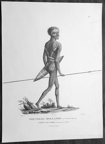
1807 Baudin & Petit Antique Print of a Sydney & Port Jackson Aboriginal Warrior
- Title : Nouvelle-Hollande. Nelle Galles Du Sud. Nourou-gal-derri & avancant pour combattre
- Size: 14in x 10in (355mm x 255mm)
- Condition: (A+) Fine Condition
- Date : 1807
- Ref #: 91240
Description:
This exquisite, rare original copper-plate engraved antique print of an Aboriginal warrior of Port Jackson carrying a spear & shield, was engraved by Barthélemy Roger, after the 1802 drawing by Nicolas-Martin Petit and was published by Francois Peron (1775 - 1810) in the 1st edition atlas of Nicolas Thomas Baudins expedition to Australia Voyage de découvertes aux Terres Australes in 1807.
This is a wonderful original stipple point engraving by Petit & Roger bringing to life this wonderful 1st Australian.
Nicholas Martin Petit sailed with Nicolas Baudin on the expedition of the Géographe and the Naturaliste in late 1800. The scientific field of anthropology was in its infancy – the French had founded the Society of the Observers of Man in 1799. Having embarked as a fourth-class gunner’s mate, Petit, who had had some graphic arts training, became one of the expeditions two illustrators when the official artists quit. From June to November 1802, the expedition was delayed in Sydney while its two ships were repaired. During this time Petit completed portraits of people of the Cadigal, Dharawal, Gweagal, Kurringai and Darug language groups of the Sydney Harbour region. While the sitters names appear to be noted on the works, it is possible that the inscriptions merely reflect French misinterpretation of the Aborigines communications with them.
The portrait of Nourou-gal-derri is pictured advancing for battle.
General Definitions:
Paper thickness and quality: - Heavy and stable
Paper color : - off white
Age of map color: -
Colors used: -
General color appearance: -
Paper size: - 14in x 10in (355mm x 255mm)
Plate size: - 12 1/2in x 9 1/2in (320mm x 240mm)
Margins: - Min 1/2in (12mm)
Imperfections:
Margins: - None
Plate area: - 2 small repair to left margin, no loss
Verso: - None
Background:
The Baudin Expedition of 1800 to 1803 was a French expedition to map the coast of New Holland, Australia. The expedition started with two ships, Géographe, captained by Baudin, and Naturaliste captained by Jacques Hamelin, and was accompanied by nine zoologists and botanists, including Jean-Baptiste Leschenault de la Tour, François Péron and Charles-Alexandre Lesueur as well as the geographer Pierre Faure.
The Baudin expedition departed Le Havre, France, on 19 October 1800. Because of delays in receiving his instructions and problems encountered in Isle de France (now Mauritius) they did not reach Cape Leeuwin on the south-west corner of Australia until May 1801. Upon rounding Cape Naturaliste, they entered Geographe Bay. They then sailed north, but the ships became separated and did not meet again until they reached Timor. On their journeys the Géographe and the Naturaliste surveyed large stretches of the north-western coast. The expedition was severely affected by dysentery and fever, but sailed from Timor on 13 November 1801, back down the north-west and west coast, then across the Great Australian Bight, reaching Tasmania on 13 January 1802. They charted the whole length of Tasmanias east coast and there were extensive interactions with the Indigenous Tasmanians, with whom they had peaceful relationships. They notably produced precious ethnological studies of Indigenous Tasmanians.
The expedition then began surveying the south coast of Australia, but then Captain Jacques Felix Emmanuel Hamelin in Naturaliste decided to make for Port Jackson (Sydney) as he was running short of food and water, and in need of anchors. En route, in April 1802, Hamelin explored the area of Western Port, Victoria, and gave names to places, a number of which have survived, for example, Ile des Français is now called French Island.
Meanwhile, Baudin in the Géographe continued westward, and in April 1802 encountered the British ship Investigator commanded by Matthew Flinders, also engaged in charting the coastline, at Encounter Bay in what is now South Australia. Flinders informed Baudin of his discovery of Kangaroo Island, St. Vincents and Spencers Gulfs. Baudin sailed on to the Nuyts Archipelago, the point reached by t Gulden Zeepaert in 1627 before heading for Port Jackson as well for supplies.
In late 1802 the expedition was at Port Jackson, where the government sold 60 casks of flour and 25 casks of salt meat to Baudin to resupply his two vessels. The supplies permitted Naturaliste to return to France and Géographe to continue her explorations of the Australian coast. Naturaliste took with her the Colonys staff surgeon, Mr. James Thomson, whom Governor Philip Gidley King had given permission to return to England.
Before resuming the voyage Baudin purchased a 30 ton schooner, which he named the Casuarina, a smaller vessel which could conduct close inshore survey work. He sent the larger Naturaliste under Hamelin back to France with all the specimens that had been collected by Baudin and his crew. As the voyage had progressed Louis de Freycinet, now a Lieutenant, had shown his talents as an officer and a hydrographer and so was given command of the Casuarina. The expedition then headed for Tasmania and conducted further charting of Bass Strait before sailing west, following the west coast northward, and after another visit to Timor, undertook further exploration along the north coast of Australia. Plagued by contrary winds, ill health, and because the quadrupeds and emus were very sick, it was decided on 7 July 1803 to return to France. On the return voyage, the ships stopped in Mauritius, where Baudin died of tuberculosis on 16 September 1803. The expedition finally reached France on 24 March 1804.
The scientific expedition was considered a great success, with more than 2500 new species discovered.
Nicolas-Martin Petit 1777 – 1804
Nicholas-Martin Petit was born in Paris, the son of a fan maker, and learned graphic art in the studio of Jacques Louis David. He avoided conscription into Napoleons armies, but wanting to travel, signed up with post Captain Nicholas Baudin on a voyage to the antipodes sponsored by the French government. Petit and fellow artist Charles-Alexandre Lesueur were enlisted directly by Baudin (as 4th class gunners mates) while the two official artists were hired by the organisers of the expedition. Baudin set off in two lavishly equipped vessels, the Géographe and the Naturaliste on 19 October 1800. By the time the expedition reached Mauritius the official artists had quit. Petit and Lesueur took over their duties, but as neither was trained in scientific method or presentation, the value of their work was primarily aesthetic. The French were at this time developing a new scientific field - anthropology. The Society of the Observers of Man was founded in 1799 for this purpose. The study of Man formed part of the background for Petits sensitive drawings and paintings of the indigenous people of Van Diemens Land, Port Jackson and Western Australia. Lesueur focused on the depiction of animals. The expedition charted the coast of Western Australia and Van Diemens land but was plagued by scurvy. On 20 June 1802 the two ships limped into Port Jackson and stayed for five months to refit, during which time Petit completed a number of portraits of Sydney Indigenous people, including the two images of the Eora men, Cour-rou-bari-gal and Y-erren-gou-la-ga. Petit eventually returned to France in 1804. However, before he was well enough to complete the drawings from the expedition he was hurt in a street accident, and he died at the age of 28. Petits unfinished work was first published in 1807 in the Atlas of the Voyage de découvertes aux terres australes and as discrete prints.
Baudin, Nicolas Thomas 1754 – 1803
Baudin was a French explorer, cartographer, naturalist and hydrographer. Born a commoner in Saint-Martin-de-Ré on the Île de Ré on 17 February 1754 Baudin joined the merchant navy at the age of 15 and the French East India Company at the age of 20.
Baudin then joined the La Marine Royale (French Navy) in 1774 and served in the Caribbean as an officier bleu during the American War of Independence of 1775–1783.
In 1785 Baudin and his brother Alexandre were respectively masters of the St Remy and Caroline, taking Acadian settlers from Nantes to La Nouvelle Orléans. In New Orleans local merchants contracted him to take a cargo of wood, salted meat, cod and flour to Isle de France (now Mauritius), which he did in Josephine (also called Pepita), departing New Orleans on 14 July 1786 and arriving at Isle de France on 27 March 1787. In the course of the voyage, Josephine had called at Cap‑Français in Haiti to make a contract to transport slaves there from Madagascar; while in Haiti he also encountered the Austrian botanist Franz Josef Maerter, who apparently informed him that another Austrian botanist, Franz Boos, was at the Cape of Good Hope awaiting a ship to take him to Mauritius. Josephine called at the Cape and took Boos on board. At Mauritius, Boos chartered Baudin to transport him and the collection of plant specimens he had gathered there and at the Cape back to Europe, which Baudin did, Josephine arriving at Trieste on 18 June 1788. The Imperial government in Vienna was contemplating organizing another natural-history expedition, to which Boos would be appointed, in which two ships would be sent to the Malabar and Coromandel coasts of India, the Persian Gulf, Bengal, Ceylon, Sumatra, Java, Borneo, Cochin China, Tongking, Japan and China. Baudin had been given reason to hope that he would be given command of the ships of this expedition.
Later in 1788 Baudin sailed on a commercial voyage from Trieste to Canton in Jardiniere. He apparently arrived at Canton from Mauritius under the flag of the United States of America, probably to avoid the possibility of having his ship seized by the Chinese for payment of the debts owed them by the Imperial Asiatic Company of Trieste. From there, he sent Jardiniere under her second captain on a fur-trading venture to the north-west coast of America, but the ship foundered off Asuncion Island in the Marianas in late 1789.
Baudin made his way to Mauritius, where he purchased a replacement ship, Jardiniere II, but this vessel was wrecked in a cyclone that struck Port Louis on 15 December 1789. Baudin embarked on the Spanish Royal Philippines Company ship, Placeres, which sailed from Port Louis for Cadiz in August 1790. Placeres called at the Cape of Good Hope where it took on board the large number of plant and animal specimens collected in South Africa for the Imperial palace at Schönbrunn by Georg Scholl, the assistant of Franz Boos. Because of the poor condition of the ship, Placeres had to put in at the island of Trinidad in the West Indies, where Scholls collection of specimens was deposited.
Baudin proceeded to Martinique, from where he addressed an offer to the Imperial government in Vienna to conduct to Canton commissioners who would be empowered to negotiate with the Chinese merchants there a settlement of the debts incurred by the Imperial Asiatic Company, which would enable the company to renew its trade with China. On its return voyage from Canton, the proposed expedition would call at the Cape of Good Hope to pick up Scholl and the remainder of his natural-history collection for conveyance to Schönbrunn.
After returning to Vienna in September 1791, Baudin continued to press his case for an expedition under the Imperial flag to the Indian Ocean and China, and in January 1792 he was granted a commission of captain in the Imperial navy for this purpose. A ship, called Jardiniere, was acquired and the botanists Franz Bredemeyer and Joseph van der Schot appointed to the expedition. After delays caused by the outbreak of war between France and Austria (April 1792), Jardiniere departed from the Spanish port of Málaga on 1 October 1792. From the Cape of Good Hope Jardiniere sailed across the Indian Ocean to the coast of New Holland (Australia), but two consecutive cyclones prevented the expedition from doing any work there and forced Baudin to take the ship to Bombay for repairs.
From Bombay the expedition proceeded to the Persian Gulf, the Red Sea and the east coast of Africa, where it gathered botanical and zoological collections. The expedition came to an abrupt end in June 1794 when Jardiniere went aground in a storm while attempting to enter Table Bay at the Cape of Good Hope. Baudin survived the wreck and made his way to the United States, from where he went to France. He managed to send Jardinieres cargo of natural history specimens to the island of Trinidad.
In Paris, Baudin visited Antoine de Jussieu at the Museum National dHistoire Naturelle in March 1796 to suggest a botanical voyage to the Caribbean, during which he would recover the collection of specimens he had left in Trinidad. The Museum and the French government accepted the proposal, and Baudin was appointed commander of an expedition in the ship Belle Angélique, with four assigned botanists: René Maugé, André Pierre Ledru, Anselme Riedlé and Stanislas Levillain. Belle Angélique cleared Le Havre on 30 September 1796 for the Canary Islands, where the ship was condemned as unseaworthy. The expedition sailed from the Canaries in a replacement vessel, Fanny, and reached Trinidad in April 1797. The British, who had just captured the island from the Spanish in February 1797, refused to allow Baudin to recover the collection of natural-history specimens. Baudin took Fanny to St. Thomas and St. Croix, and then to Puerto Rico, specimens being collected in all three islands. At St Croix, Fanny was replaced by a newly purchased ship, renamed Belle Angelique. The expedition returned to France in June 1798 with a large collection of plants, birds and insects, which was incorporated into Napoleon Bonapartes triumphal procession celebrating his recent Italian victories.
On 24 July 1798, at the suggestion of the Ministry of Marine, Baudin presented to the Assembly of Professors and Administrators of the National Museum of Natural History a plan for a hydrographic-survey expedition to the South Seas, which would include a search for fauna and flora that could be brought back for cultivation in France. The expedition would also have the aim of promoting the economic and commercial interests of France in the regions to be visited. The expedition would require two well-equipped ships, which would carry a team of astronomers, naturalists and scientific draughtsmen over whom Baudin as commander would have absolute authority. The first part of the voyage would be devoted to a thorough exploration of the coast of Chile and the collection of animal, bird and plant specimens suitable for acclimatization in France, followed by a survey of the coasts from Peru to Mexico. The expedition would then continue into the Pacific Ocean, including a visit to Tahiti and the Society Islands, and would be completed with a survey of the yet unexplored south-west coast of New Holland (Australia). After considering this extensive proposal, the French government decided to proceed with an expedition confined to a survey of western and southern New Holland (as Australia was called at the time).
In October 1800 Baudin was selected to lead what has become known as the Baudin expedition to map the coast of Australia (New Holland). He had two ships, Géographe and Naturaliste captained by Hamelin, and a suite of nine zoologists and botanists, including Jean Baptiste Leschenault de la Tour. He reached Australia in May 1801, and would explore and map the western coast and a part of the little-known southern coast of the continent. The scientific expedition proved a great success, with more than 2500 new species discovered. The French also met Aboriginal peoples and treated them with great respect.
In April 1802 Baudin met Matthew Flinders, also engaged in charting the coastline, in Encounter Bay in present-day South Australia. Baudin then stopped at the British colony at Sydney for supplies. In Sydney he bought a new ship — Casuarina — named after the wood it was made from. From there he sent home Naturaliste, which had on board all of the specimens that had been discovered by Baudin and his crew. He then headed for Tasmania, before continuing north to Timor. Baudin then sailed for home, stopping at Mauritius.
According to recent researches by academics from the University of Adelaide, during Baudins expedition, François Péron, who had become the chief zoologist and intellectual leader of the mission, wrote a report for Napoleon on ways to invade and capture the British colony at Sydney Cove.
Baudin died of tuberculosis at Mauritius on 16 September 1803, at the age of 49, apparently in the home of Madame Alexandrine Kerivel. Baudins exact resting place is not known, but the historian Auguste Toussaint believed that he was interred in the Kerivel family vault. However, the historian Edward Duyker likes to think that Baudin was buried in Le Cimetière de lOuest in the district of Port Louis just a few hundred metres from the explorers certain love: the sea.
Please note all items auctioned are genuine, we do not sell reproductions. A Certificate of Authenticity (COA) can be issued on request.
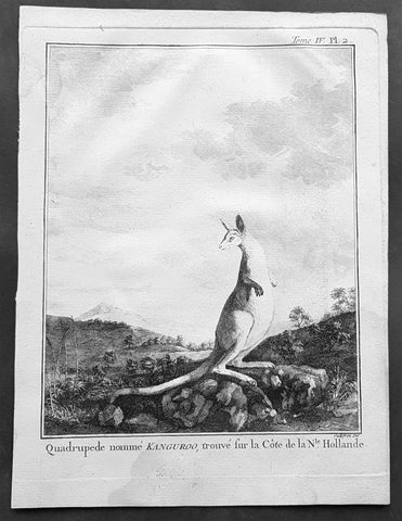
1774 Capt. Cook, S. Parkinson & G. Stubbs - Antique Print Australian Kangaroo in 1770
- Title : Quadrupede nomme Kanguroo trouve fur la Cote de la N.Hollande
[The Kanguroo, an Animal found on the Coast of New Holland] - Ref : 35016
- Size: 10in x 8in (255mm x 205mm)
- Date : 1774
- Condition: (A+) Fine Condition
Description:
This fine original copper-plate engraved antique print of a Kangaroo, first sketched by Sydney Parkinson onboard HMS Endeavour during Cooks first voyage in 1770, whilst laid up at Endeavour River in northern Queensland, was engraved by Robert Benard, after a painting by the famous English Artist George Stubbs in 1772. This original engraving was published in the 1774 French edition of Capt. James Cooks 1st Voyage of Discovery to the South Seas by John Hawkesworth in An Account of the Voyages Undertaken by the Order of His Present Majesty for Making Discoveries in the Southern Hemisphere and Successively Performed by Commodore Byron, Captain Wallis, Captain Carteret, and Captain Cook, in the Dolphin, the Swallow, and the Endeavor, Drawn Up from the Journals Which Were Kept by the Several Commanders, and from the Papers of Joseph Banks. Paris, 1774.
From Sydney Parkinsons Journal........soon after we arrived in the bay, we laid the ship on a steep bank, on the side of a river; set up tents on shore, unloaded her, carried all the cargo and provisions into them, and there lodged and accommodated our sick.
On the 22d, we examined the ship’s bottom, and found a large hole; through the planks into the hold, which had a piece of coral-rock, half a yard square, sticking in it: the same rock, therefore, that endangered us, yielded us the principal means of our redemption; for, had not this fragment intruded into the leak, in all probability the ship would have sunk.
We lost no time, but immediately set about repairing the ship’s bottom, and in a few days made it sound again. In the mean time, the boats were sent out, in search of another passage, which they found, and returned to the ship on the 3d of July.
On the 4th of July, the ship was carried to the other side of the river, and examined thoroughly; but, being found in good condition, she was soon placed in her former station; where she was loaded, and properly fitted to proceed on the voyage.
During the time we staid here, we picked up a great many natural curiosities from the reef we struck upon, consisting of a variety of curious shells, most of which were entirely new to Mr. Banks and Dr. Solander ...
Of quadrupeds, there are goats, wolves, a small red animal about the size of a squirrel; a spotted one of the viverra kind, and an animal of a kind nearly approaching the mus genus, about the size of a grey-hound, that had a head like a fawn’s; lips and ears, which it throws back, like a hare’s; on the upper jaw six large teeth; on the under one two only; with a short and small neck, near to which are the fore-feet, which have five toes each, and five hooked claws; the hinder legs are long, especially from the last joint, which, from the callosity below it, seems as if it lies flat on the ground when the animal descends any declivity; and each foot had four long toes, two of them behind, placed a great way back, the inner one of which has two claws; the two other toes were in the middle, and resembled a hoof, but one of them was much larger than the other. The tail, which is carried like a grey-hound’s, was almost as long as the body, and tapered gradually to the end. The chief bulk of this animal is behind; the belly being largest, and the back rising toward the posteriors. The whole body is covered with short ash-coloured hair; and the flesh of it tasted like a hare’s, but has a more agreeable flavour................
General Definitions:
Paper thickness and quality: - Heavy and stable
Paper color : - off white
Age of map color: -
Colors used: -
General color appearance: -
Paper size: - 10in x 8in (255mm x 205mm)
Plate size: - 9 1/2in x 7 1/4in (240mm x 185mm)
Margins: - Min 1/2in (12mm)
Imperfections:
Margins: - Light soiling in margins
Plate area: - None
Verso: - None
Background:
Sydney Parkinson 1745 – 71 was draughtsman to the botanist Sir Joseph Banks on James Cook’s first voyage to the Pacific in 1768. He died of dysentery in 1771, on the homeward voyage.
Parkinson was the first European artist to create drawings of Indigenous Australian, Maori & South Sea peoples, as well as landscapes, from direct observation. Hundreds of his original drawings survive in the British Museum. He is particularly remembered for his plant illustrations which were later used to create the lavish plates for Joseph Banks’ Florilegium.
When the Endeavour returned to England in 1772, a dispute arose between Joseph Banks and Sydney’s brother, Stanfield Parkinson. As his employer, Banks claimed rights to Sydney’s drawings, papers and collections made on the voyage. Stanfield claimed that Sydney had willed them to his family. Banks lent the Parkinson family Sydney’s journal and drawings with instructions that they were not to be published, however Stanfield disregarded this and arranged for A Journal of a voyage to the South Seas to be printed from Sydney’s account of the voyage.
Banks managed to suppress Stanfield’s publication until the official account of the voyage, edited by John Hawkesworth, appeared. In return for Parkinson’s papers, Banks paid Stanfield Parkinson 500 pounds for balance of wages due to Sydney, but the dispute did not end there. Stanfield further accused Banks of retaining items collected by Sydney which were intended for his relatives. Stanfield Parkinson was declared insane soon after the publication of Sydney Parkinson’s Journal and died in an asylum.
John Hawkesworth An English writer and journalist, Hawkesworth was commissioned by the British Admiralty to edit for publication the narratives of its officers’ circumnavigations. He was given full access to the journals of the commanders and the freedom to adapt and re-tell them in the first person. Cook was already on his way back from his second Pacific voyage, temporarily docked at Cape Town (South Africa), when he first saw the published volumes: he was mortified and furious to find that Hawkesworth claimed in the introduction that Cook had seen and blessed (with slight corrections) the resulting manuscript. (In his defense, Hawkesworth also had been a victim of misunderstanding.) Cook had trouble recognizing himself. Moreover, the work was full of errors and commentary introduced by Hawkesworth and, in Cook’s view, too full of Banks, who had promoted himself and the publication. Still, the work was popular; the first edition sold out in several months.
Robert Bénard 1734 – 1777 was an 18th-century French engraver.
Specialized in the technique of engraving, Robert Ménard is mainly famous for having supplied a significant amount of plates (at least 1,800) to the Encyclopédie by Diderot & d\'Alembert from 1751.
Later, publisher Charles-Joseph Panckoucke reused many of his productions to illustrate the works of his catalog.
George Stubbs ARA 1724 – 1806 was an English painter, best known for his paintings of horses. His most famous work is probably Whistlejacket, a painting of a prancing horse commissioned by the 2nd Marquess of Rockingham, which is now in the National Gallery in London. This and two other paintings carried out for Rockingham break with convention in having plain backgrounds. Throughout the 1760s he produced a wide range of individual and group portraits of horses, sometimes accompanied by hounds. He often painted horses with their grooms, whom he always painted as individuals. Meanwhile, he also continued to accept commissions for portraits of people, including some group portraits. From 1761 to 1776 he exhibited at the Society of Artists of Great Britain, but in 1775 he switched his allegiance to the recently founded but already more prestigious Royal Academy of Arts.
Stubbs also painted more exotic animals including lions, tigers, giraffes, monkeys, and rhinoceroses, which he was able to observe in private menageries. His painting of a kangaroo in 1772 after Cooks 1st Voyage to Australia, was the first glimpse of this animal for many 18th-century Britons
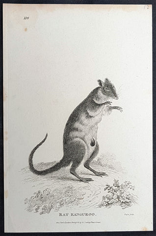
1800 George Kearsley Shaw Antique Early Print The Australian Musky Rat Kangaroo
- Title : Rat Kangaroo...1800 Jan 1 London Published by G Kearsley Fleet St.
- Date : 1800
- Condition: (A+) Fine Condition
- Ref: 33077
- Size: 8 1/2in x 5in (215mm x 125mm)
Description:
This original copper-plate engraved antique print of the Australian Musky rat-kangaroo was engraved by Isaac Taylor (1730-1807) in 1800 - dated - and published by George Kearsley Shaw in the 1803 edition of the Zoology of New Holland one of the earliest publications to name many Australian animals, for the first time.
General Definitions:
Paper thickness and quality: - Heavy and stable
Paper color : - off white
Age of map color: -
Colors used: -
General color appearance: -
Paper size: - 8 1/2in x 5in (215mm x 125mm)
Plate size: - 8 1/2in x 5in (215mm x 125mm)
Margins: - Min 1/2in (12mm)
Imperfections:
Margins: - Light age toning
Plate area: - None
Verso: - None
Background:
The musky rat-kangaroo is a marsupial species found only in the rainforests of northeast Australia. Although some scientists place this species as a subfamily (Hypsiprymnodontinae) of the family Potoroidae, the most recent classification places it in the family Hypsiprymnodontidae with prehistoric rat-kangaroos.
It is the smallest macropod that is quadrupedal and only diurnal. The musky rat-kangaroo is about 21 to 34 cm long with a 6.5- to 12.3-cm-long hairless tail, weighs between 332 and 680 g, and eats fallen fruit and large seeds, as well as small invertebrates.
It moves by extending its body and then bringing both of its hind legs forward, and uses an opposable digit on the hind foot to climb trees.
Shaw, George Kearsley 1751 - 1813
Shaw was an English botanist and zoologist. He was born at Bierton, Buckinghamshire, and was educated at Magdalen Hall, Oxford, receiving his M.A. in 1772. He took up the profession of medical practitioner. In 1786 he became the assistant lecturer in botany at Oxford University. He was a co-founder of the Linnean Society in 1788, and became a fellow of the Royal Society in 1789.
In 1791 Shaw became assistant keeper of the natural history department at the British Museum, succeeding Edward Whitaker Gray as keeper in 1806. He found that most of the items donated to the museum by Hans Sloane were in very bad condition. Medical and anatomical material was sent to the museum at the Royal College of Surgeons, but many of the stuffed animals and birds had deteriorated and had to be burnt. He was succeeded after his death by his assistant Charles Konig.
Shaw published one of the first English descriptions with scientific names of several Australian animals in his Zoology of New Holland first published in 1794. He was among the first scientists to examine a platypus and published the first scientific description of it in The Naturalists Miscellany in 1799.
In the field of herpetology he described numerous new species of reptiles and amphibians.
His other publications included:
- Musei Leveriani explicatio, anglica et Latina, containing select specimens from the museum of the late Sir Ashton Lever (1792–6), which had been moved to be displayed at the Blackfriars Rotunda.
- General Zoology, or Systematic Natural History (16 vol.) (1809–1826) (volumes IX to XVI by James Francis Stephens)
- The Naturalist\\\'s Miscellany: Or, Coloured Figures Of Natural Objects; Drawn and Described Immediately From Nature (1789–1813) with Frederick Polydore Nodder (artist and engraver).
The standard botanical author abbreviation G.Shaw is applied to species he described.
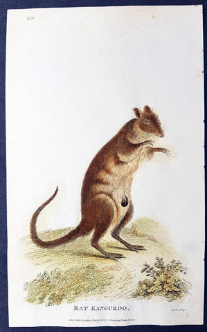
1800 George Kearsley Shaw Antique Early Print The Australian Musky Rat Kangaroo
- Title : Rat Kangaroo...1800 Jan 1 London Published by G Kearsley Fleet St.
- Date : 1800
- Condition: (A+) Fine Condition
- Ref: 33115
- Size: 8 1/2in x 5in (215mm x 125mm)
Description:
This beautifully hand coloured original copper-plate engraved antique print of the Australian Musky rat-kangaroo was engraved by Isaac Taylor (1730-1807) in 1800 - dated - and published by George Kearsley Shaw in the 1803 edition of the Zoology of New Holland one of the earliest publications to name many Australian animals, for the first time.
General Definitions:
Paper thickness and quality: - Heavy and stable
Paper color : - off white
Age of map color: - Original
Colors used: - Yellow, green, blue, pink
General color appearance: - Authentic
Paper size: - 8 1/2in x 5in (215mm x 125mm)
Plate size: - 8 1/2in x 5in (215mm x 125mm)
Margins: - Min 1/2in (12mm)
Imperfections:
Margins: - None
Plate area: - None
Verso: - Light spotting
Background:
The musky rat-kangaroo is a marsupial species found only in the rainforests of northeast Australia. Although some scientists place this species as a subfamily (Hypsiprymnodontinae) of the family Potoroidae, the most recent classification places it in the family Hypsiprymnodontidae with prehistoric rat-kangaroos.
It is the smallest macropod that is quadrupedal and only diurnal. The musky rat-kangaroo is about 21 to 34 cm long with a 6.5- to 12.3-cm-long hairless tail, weighs between 332 and 680 g, and eats fallen fruit and large seeds, as well as small invertebrates.
It moves by extending its body and then bringing both of its hind legs forward, and uses an opposable digit on the hind foot to climb trees.
Shaw, George Kearsley 1751 - 1813
Shaw was an English botanist and zoologist. He was born at Bierton, Buckinghamshire, and was educated at Magdalen Hall, Oxford, receiving his M.A. in 1772. He took up the profession of medical practitioner. In 1786 he became the assistant lecturer in botany at Oxford University. He was a co-founder of the Linnean Society in 1788, and became a fellow of the Royal Society in 1789.
In 1791 Shaw became assistant keeper of the natural history department at the British Museum, succeeding Edward Whitaker Gray as keeper in 1806. He found that most of the items donated to the museum by Hans Sloane were in very bad condition. Medical and anatomical material was sent to the museum at the Royal College of Surgeons, but many of the stuffed animals and birds had deteriorated and had to be burnt. He was succeeded after his death by his assistant Charles Konig.
Shaw published one of the first English descriptions with scientific names of several Australian animals in his Zoology of New Holland first published in 1794. He was among the first scientists to examine a platypus and published the first scientific description of it in The Naturalists Miscellany in 1799.
In the field of herpetology he described numerous new species of reptiles and amphibians.
His other publications included:
- Musei Leveriani explicatio, anglica et Latina, containing select specimens from the museum of the late Sir Ashton Lever (1792–6), which had been moved to be displayed at the Blackfriars Rotunda.
- General Zoology, or Systematic Natural History (16 vol.) (1809–1826) (volumes IX to XVI by James Francis Stephens)
- The Naturalist\\\'s Miscellany: Or, Coloured Figures Of Natural Objects; Drawn and Described Immediately From Nature (1789–1813) with Frederick Polydore Nodder (artist and engraver).
The standard botanical author abbreviation G.Shaw is applied to species he described.
1824 Louis Freycinet & Paul-Louis Oudart Antique Print Rufous-Bellied Kookaburra
- Title : Martin-Chasseur Gaudichaud: (Dacelo Gaudichaud. N.)
- Ref #: 31741
- Size: 18in x 12in (460mm x 305mm)
- Date : 1824
- Condition: (A+) Fine Condition
Description:
This magnificent large hand coloured original copper-plate engraved antique print of The Rufous-Bellied Kookaburra of Australia & Papua New Guinea (Plate no. 25) by Paul-Louis Oudart (visited by Louis Freycinet in late 1818) was engraved by Jean-Louis-Denis Coutant (1776-1831) and published in the 1824 1st edition of Louis De Freycinets Atlas of Mammals, Birds etc Voyage autour du monde fait par ordre du Roi sur les corvettes de S. M. l\'Uranie et la Physicienne, pendant les années 1817, 1818, 1819 et 1820
These magnificent large hand coloured 1st edition engravings are extremely scarce and a must for ny collection.
The Rufous-Bellied Kookaburra (Dacelo gaudichaud), originally known as Gaudichauds kookaburra after the French botanist Charles Gaudichaud-Beaupré, is a species of kookaburra which is widely distributed through the forests of lowland New Guinea. It has also been recorded on Saibai Island, Queensland, Australia.
General Definitions:
Paper thickness and quality: - Heavy and stable
Paper color : - off white
Age of map color: - Original
Colors used: - Yellow, green, blue, pink
General color appearance: - Authentic
Paper size: - 18in x 12in (460mm x 305mm)
Plate size: - 13in x 9 ½in (330mm x 240mm)
Margins: - Min 2in (50mm)
Imperfections:
Margins: - Light soiling & spotting
Plate area: - None
Verso: - Light soiling & spotting
Background:
After the Restoration the French government gave Freycinet, then a captain, command of another expedition to circumnavigate the globe and conduct research into the shape of the earth, meteorology and terrestrial magnetism. He sailed from Toulon on 17 September 1817 in L Uranie with his wife Rose who secreted herself aboard, and who wrote a separate account of the voyage. After refreshing at the Cape of Good Hope and Mauritius he landed at Shark Bay, Western Australia on 12 September 1818 where he set up an observatory, thoroughly surveyed the inlets and the coastal districts and removed the plate left by Willem de Vlamingh, which he had found and re-erected in 1801. He then sailed north to Timor. His accounts and description of the landscape and life and customs of that and other islands in the East Indies captivated the attention of people in Europe much more than his Australian reports, and a widespread interest developed in the expedition. Leaving Timor on 27 November he sailed via the Moluccas, the Carolines, the Marianas, and the Sandwich Islands and reached Port Jackson on 19 November 1819, the scientists on board adding constantly to their store of information on hydrography, botany, cartography and anthropology. After spending Christmas ashore, they sailed on 26 December and, falling in with the westerlies, set a course for Cape Horn.
On 13 February 1820 L Uranie was wrecked on the Falkland Islands; the scientific records and notes were saved before the vessel foundered, but 2500 of the 4175 plant specimens were lost. Freycinet returned to France in November 1820 and died on 18 August 1842.
There is no evidence in the expedition\'s records or French governmental archives to suggest that there were political objectives in this circumnavigation but, though its purpose was to engage in scientific discovery, this first major voyage undertaken by the restored Bourbons did show the French flag in distant seas and foreshadowed a series of other expeditions which were not wholly scientific.
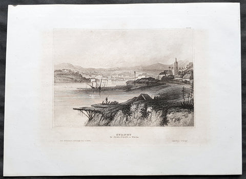
1835 Joseph Meyer Antique Print Early View of The Rocks Sydney, Australia
- Title : Sydney in New South Wales
- Ref #: 50668
- Size: 10in x 7 1/2in (255mm x 190mm)
- Date : 1835
- Condition: (A+) Fine Condition
Description:
This fine steel-plate engraved original antique print an early view of The Rocks in Sydney Australia by Joseph Meyer was published in the 1835 edition of Meyers Universum
These are beautiful steel-plate engraved prints, with a high level of detail along with beautifully executed artistry.
General Definitions:
Paper thickness and quality: - Heavy and stable
Paper color : - off white
Age of map color: -
Colors used: -
General color appearance: -
Paper size: - 10in x 7 1/2in (255mm x 190mm)
Plate size: - 10in x 7 1/2in (255mm x 190mm)
Margins: - Min 1/2in (12mm)
Imperfections:
Margins: - None
Plate area: - None
Verso: - None
Background:
The History of Sydney begins in prehistoric times with the occupation of the district by Australian Aborigines, whose ancestors came to Sydney in the Upper Paleolithic period. The modern history of the city began with the arrival of a First Fleet of British ships in 1788 and the foundation of a penal colony by Great Britain.
From 1788 to 1900 Sydney was the capital of the British colony of New South Wales. An elected city council was established in 1840. In 1900, Sydney became a state capital, when New South Wales voted to join the Australian Federation. Sydney today is Australia\'s largest city and a major international capital of culture and finance. The city has played host to many international events, including the 2000 Summer Olympics.
Meyer, Joseph 1796 - 1856
Meyer was a German industrialist and publisher, most noted for his encyclopedia, Meyers Konversations-Lexikon.
Meyer was born at Gotha, Germany, and was educated as a merchant in Frankfurt am Main. He went to London in 1816, but returned to Germany in 1820 after business adventures and stock speculations fell through. Here he invested in enterprises like textile-trade (1820–24). Soon after the first steam-hauled railway had started in December 1835, Meyer started to make business plans how to start the first railways. He also bought some concessions for iron mining. In 1845, he founded the Deutsche Eisenbahnschienen-Compagnie auf Actien (German Railway Rail joint stock company).
Meyer operated very successfully as a publisher, employing a system of serial subscription to publications, which was new at that time. To this end he founded a company, Bibliographisches Institut, in Gotha in 1826. It published several editions of the Bible, works of classical literature (Miniatur-Bibliothek der deutschen Classiker, Groschen-Bibliothek), atlases, the world in pictures on steel engravings Meyers Universum, 1833–61, 17 volumes in 12 languages with 80,000 subscribers all over Europe), and an encyclopaedia, (das Grosse Conversations-Lexikon für die gebildeten Stände;). His company grew substantially, and in 1828 he moved it from Gotha to Hildburghausen, where he died thirty years later.
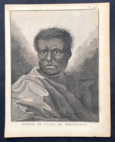
1778 Capt. Cook Antique Print Portrait A Man of Malakula Island Vanuatu in 1774
- Title : Homme de L Isle de Mallicolo
- Ref : 31831
- Size: 10in x 8in (255mm x 205mm)
- Date : 1778
- Condition: (A+) Fine Condition
Description:
This fine original copper-plate engraved antique print, portrait of a Man of the Island of Malakula (Mallicolo) in the Vanuatu group of Islands in the South Pacific, visited by Captain James Cook during his 2nd Voyage of Discovery in the South Seas in September 1774, was engraved by Robert Benard - after William Hodges - and was published in the 1778 French edition of Capt. James Cooks 2nd Voyage of Discovery to the South Seas A voyage towards the South Pole, and round the World. Performed in His Majestys ships the Resolution and Adventure, in the years 1772, 1773, 1774, and 1775..... Paris : Hotel de Thou ......1778
Cook Journal July, 1774
Arrival at The New Hebrides
On 17th Cook saw land bearing SW and later on decided this was the Australia Del Espiritu Santo of Quiros or what M. D. Bougainville calls the Great Cyclades. The island was Maewo. The next day its northern end was rounded in a gale and the ship sailed south between it and the island called by Bougainville the Isle of Lepers - Omba.
On 20th they crossed Patteson Passage with a view of geting to the South to explore the lands which lies there, and sailed down the west coast of Pentecost Isle (Raga). To the south they saw the island of Ambrin and behind it Paama and Epi. On 22nd, approaching Mallicollo (Malekula) we perceived a creek which had the appearence of a good harbour. Cook sent Lieutt [Richard] Pickersgill and the Master [Joseph Gilbert] in two Armd boats to Sound and look for Anchorage. The following day a good many [natives] came round us, some came in Canoes and others swam off\'... four I took into the Cabbin and made them various presents. Later, after some misunder-standing some natives began to Shoot Arrows... a Musquet discharged in the air and a four pounder over their heads sent them all off in the utmost confusion; those in the Cabbin leaped out of the Windows... About 9 o\'Clock we landed in the face of about 4 or 500 Men who were assembled on the Shore, armd with Bows and Arrows, clubs and Spears, but they made not the least opposission, on the contrary one Man gave his Arms to a nother and Met us in the water with a green branch in his hand, which [he] exchanged for the one I held in my hand. Just before departing Cook remarked they have not so much as a name for a Dog, consequently can have none, for which reason we left them a Dog and a Bitch.
General Definitions:
Paper thickness and quality: - Heavy and stable
Paper color : - off white
Age of map color: -
Colors used: -
General color appearance: -
Paper size: - 10in x 8in (255mm x 205mm)
Plate size: - 9 1/2in x 7 1/4in (240mm x 185mm)
Margins: - Min 1/2in (12mm)
Imperfections:
Margins: - Light soiling in margins
Plate area: - None
Verso: - None
Background:
Malakula Island also spelled Malekula, is the second-largest island in the nation of Vanuatu, in the Pacific Ocean region of Melanesia.
Discovered by the Spanish expedition of Pedro Fernández de Quirós in 1606 and visited by Captain Cook in 1774.
Vanuatu officially the Republic of Vanuatu is a Pacific island nation located in the South Pacific Ocean. The archipelago, which is of volcanic origin, is 1,750 kilometres east of northern Australia, 540 kilometres northeast of New Caledonia, east of New Guinea, southeast of the Solomon Islands, and west of Fiji.
Vanuatu was first inhabited by Melanesian people. The first Europeans to visit the islands were a Spanish expedition led by Portuguese navigator Fernandes de Queirós, who arrived on the largest island in 1606. Since the Portuguese and Spanish monarchies had been unified under the king of Spain in 1580 (following the vacancy of the Portuguese throne, which lasted for sixty years, until 1640, when the Portuguese monarchy was restored), Queirós claimed the archipelago for Spain, as part of the colonial Spanish East Indies, and named it La Austrialia del Espiritu Santo.
The Vanuatu group of islands first had contact with Europeans in 1606, when the Portuguese explorer Pedro Fernandes de Queiros, sailing for the Spanish Crown, arrived on the largest island and called the group of islands La Austrialia del Espiritu Santo or The Southern Land of the Holy Spirit, believing he had arrived in Terra Australis or Australia. The Spanish established a short-lived settlement at Big Bay on the north side of the island. The name Espiritu Santo remains to this day.
Europeans did not return until 1768, when Louis Antoine de Bougainville rediscovered the islands on 22 May, naming them the Great Cyclades. In 1774, Captain Cook named the islands the New Hebrides, a name that would last until independence in 1980.
William Hodges RA 1744 – 1797 was an English painter. He was a member of James Cooks second voyage to the Pacific Ocean, and is best known for the sketches and paintings of locations he visited on that voyage, including Table Bay, Tahiti, Easter Island, and the Antarctic.
Between 1772 and 1775 Hodges accompanied James Cook to the Pacific as the expeditions artist. Many of his sketches and wash paintings were adapted as engravings in the original published edition of Cooks journals from the voyage.
Most of the large-scale landscape oil paintings from his Pacific travels for which Hodges is best known were finished after his return to London; he received a salary from the Admiralty for the purposes of completing them. These paintings depicted a stronger light and shadow than had been usual in European landscape tradition. Contemporary art critics complained that his use of light and colour contrasts gave his paintings a rough and unfinished appearance.
Hodges also produced many valuable portrait sketches of Pacific islanders and scenes from the voyage involving members of the expedition..
Robert Bénard 1734 – 1777 was an 18th-century French engraver.
Specialized in the technique of engraving, Robert Ménard is mainly famous for having supplied a significant amount of plates (at least 1,800) to the Encyclopédie by Diderot & d\'Alembert from 1751.
Later, publisher Charles-Joseph Panckoucke reused many of his productions to illustrate the works of his catalog.
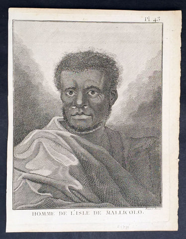
1778 Capt. Cook Antique Print Portrait A Man of Malakula Island Vanuatu in 1774
- Title : Homme de L Isle de Mallicolo
- Ref : 21347
- Size: 10in x 8in (255mm x 205mm)
- Date : 1778
- Condition: (A+) Fine Condition
Description:
This fine original copper-plate engraved antique print, portrait of a Man of the Island of Malakula (Mallicolo) in the Vanuatu group of Islands in the South Pacific, visited by Captain James Cook during his 2nd Voyage of Discovery in the South Seas in September 1774, was engraved by Robert Benard - after William Hodges - and was published in the 1778 French edition of Capt. James Cooks 2nd Voyage of Discovery to the South Seas A voyage towards the South Pole, and round the World. Performed in His Majestys ships the Resolution and Adventure, in the years 1772, 1773, 1774, and 1775..... Paris : Hotel de Thou ......1778
Cook Journal July, 1774
Arrival at The New Hebrides
On 17th Cook saw land bearing SW and later on decided this was the Australia Del Espiritu Santo of Quiros or what M. D. Bougainville calls the Great Cyclades. The island was Maewo. The next day its northern end was rounded in a gale and the ship sailed south between it and the island called by Bougainville the Isle of Lepers - Omba.
On 20th they crossed Patteson Passage with a view of geting to the South to explore the lands which lies there, and sailed down the west coast of Pentecost Isle (Raga). To the south they saw the island of Ambrin and behind it Paama and Epi. On 22nd, approaching Mallicollo (Malekula) we perceived a creek which had the appearence of a good harbour. Cook sent Lieutt [Richard] Pickersgill and the Master [Joseph Gilbert] in two Armd boats to Sound and look for Anchorage. The following day a good many [natives] came round us, some came in Canoes and others swam off\'... four I took into the Cabbin and made them various presents. Later, after some misunder-standing some natives began to Shoot Arrows... a Musquet discharged in the air and a four pounder over their heads sent them all off in the utmost confusion; those in the Cabbin leaped out of the Windows... About 9 o\'Clock we landed in the face of about 4 or 500 Men who were assembled on the Shore, armd with Bows and Arrows, clubs and Spears, but they made not the least opposission, on the contrary one Man gave his Arms to a nother and Met us in the water with a green branch in his hand, which [he] exchanged for the one I held in my hand. Just before departing Cook remarked they have not so much as a name for a Dog, consequently can have none, for which reason we left them a Dog and a Bitch.
General Definitions:
Paper thickness and quality: - Heavy and stable
Paper color : - off white
Age of map color: -
Colors used: -
General color appearance: -
Paper size: - 10in x 8in (255mm x 205mm)
Plate size: - 9 1/2in x 7 1/4in (240mm x 185mm)
Margins: - Min 1/2in (12mm)
Imperfections:
Margins: - Light soiling in margins
Plate area: - None
Verso: - None
Background:
Malakula Island also spelled Malekula, is the second-largest island in the nation of Vanuatu, in the Pacific Ocean region of Melanesia.
Discovered by the Spanish expedition of Pedro Fernández de Quirós in 1606 and visited by Captain Cook in 1774.
Vanuatu officially the Republic of Vanuatu is a Pacific island nation located in the South Pacific Ocean. The archipelago, which is of volcanic origin, is 1,750 kilometres east of northern Australia, 540 kilometres northeast of New Caledonia, east of New Guinea, southeast of the Solomon Islands, and west of Fiji.
Vanuatu was first inhabited by Melanesian people. The first Europeans to visit the islands were a Spanish expedition led by Portuguese navigator Fernandes de Queirós, who arrived on the largest island in 1606. Since the Portuguese and Spanish monarchies had been unified under the king of Spain in 1580 (following the vacancy of the Portuguese throne, which lasted for sixty years, until 1640, when the Portuguese monarchy was restored), Queirós claimed the archipelago for Spain, as part of the colonial Spanish East Indies, and named it La Austrialia del Espiritu Santo.
The Vanuatu group of islands first had contact with Europeans in 1606, when the Portuguese explorer Pedro Fernandes de Queiros, sailing for the Spanish Crown, arrived on the largest island and called the group of islands La Austrialia del Espiritu Santo or The Southern Land of the Holy Spirit, believing he had arrived in Terra Australis or Australia. The Spanish established a short-lived settlement at Big Bay on the north side of the island. The name Espiritu Santo remains to this day.
Europeans did not return until 1768, when Louis Antoine de Bougainville rediscovered the islands on 22 May, naming them the Great Cyclades. In 1774, Captain Cook named the islands the New Hebrides, a name that would last until independence in 1980.
William Hodges RA 1744 – 1797 was an English painter. He was a member of James Cooks second voyage to the Pacific Ocean, and is best known for the sketches and paintings of locations he visited on that voyage, including Table Bay, Tahiti, Easter Island, and the Antarctic.
Between 1772 and 1775 Hodges accompanied James Cook to the Pacific as the expeditions artist. Many of his sketches and wash paintings were adapted as engravings in the original published edition of Cooks journals from the voyage.
Most of the large-scale landscape oil paintings from his Pacific travels for which Hodges is best known were finished after his return to London; he received a salary from the Admiralty for the purposes of completing them. These paintings depicted a stronger light and shadow than had been usual in European landscape tradition. Contemporary art critics complained that his use of light and colour contrasts gave his paintings a rough and unfinished appearance.
Hodges also produced many valuable portrait sketches of Pacific islanders and scenes from the voyage involving members of the expedition..
Robert Bénard 1734 – 1777 was an 18th-century French engraver.
Specialized in the technique of engraving, Robert Ménard is mainly famous for having supplied a significant amount of plates (at least 1,800) to the Encyclopédie by Diderot & d\'Alembert from 1751.
Later, publisher Charles-Joseph Panckoucke reused many of his productions to illustrate the works of his catalog.
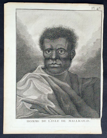
1778 Capt. Cook Antique Print Portrait A Man of Malakula Island Vanuatu in 1774
- Title : Homme de L Isle de Mallicolo
- Ref : 31773
- Size: 10in x 8in (255mm x 205mm)
- Date : 1778
- Condition: (A+) Fine Condition
Description:
This fine original copper-plate engraved antique print, portrait of a Man of the Island of Malakula (Mallicolo) in the Vanuatu group of Islands in the South Pacific, visited by Captain James Cook during his 2nd Voyage of Discovery in the South Seas in September 1774, was engraved by Robert Benard - after William Hodges - and was published in the 1778 French edition of Capt. James Cooks 2nd Voyage of Discovery to the South Seas A voyage towards the South Pole, and round the World. Performed in His Majestys ships the Resolution and Adventure, in the years 1772, 1773, 1774, and 1775..... Paris : Hotel de Thou ......1778
Cook Journal July, 1774
Arrival at The New Hebrides
On 17th Cook saw land bearing SW and later on decided this was the Australia Del Espiritu Santo of Quiros or what M. D. Bougainville calls the Great Cyclades. The island was Maewo. The next day its northern end was rounded in a gale and the ship sailed south between it and the island called by Bougainville the Isle of Lepers - Omba.
On 20th they crossed Patteson Passage with a view of geting to the South to explore the lands which lies there, and sailed down the west coast of Pentecost Isle (Raga). To the south they saw the island of Ambrin and behind it Paama and Epi. On 22nd, approaching Mallicollo (Malekula) we perceived a creek which had the appearence of a good harbour. Cook sent Lieutt [Richard] Pickersgill and the Master [Joseph Gilbert] in two Armd boats to Sound and look for Anchorage. The following day a good many [natives] came round us, some came in Canoes and others swam off\'... four I took into the Cabbin and made them various presents. Later, after some misunder-standing some natives began to Shoot Arrows... a Musquet discharged in the air and a four pounder over their heads sent them all off in the utmost confusion; those in the Cabbin leaped out of the Windows... About 9 o\'Clock we landed in the face of about 4 or 500 Men who were assembled on the Shore, armd with Bows and Arrows, clubs and Spears, but they made not the least opposission, on the contrary one Man gave his Arms to a nother and Met us in the water with a green branch in his hand, which [he] exchanged for the one I held in my hand. Just before departing Cook remarked they have not so much as a name for a Dog, consequently can have none, for which reason we left them a Dog and a Bitch.
General Definitions:
Paper thickness and quality: - Heavy and stable
Paper color : - off white
Age of map color: -
Colors used: -
General color appearance: -
Paper size: - 10in x 8in (255mm x 205mm)
Plate size: - 9 1/2in x 7 1/4in (240mm x 185mm)
Margins: - Min 1/2in (12mm)
Imperfections:
Margins: - Light soiling in margins
Plate area: - None
Verso: - None
Background:
Malakula Island also spelled Malekula, is the second-largest island in the nation of Vanuatu, in the Pacific Ocean region of Melanesia.
Discovered by the Spanish expedition of Pedro Fernández de Quirós in 1606 and visited by Captain Cook in 1774.
Vanuatu officially the Republic of Vanuatu is a Pacific island nation located in the South Pacific Ocean. The archipelago, which is of volcanic origin, is 1,750 kilometres east of northern Australia, 540 kilometres northeast of New Caledonia, east of New Guinea, southeast of the Solomon Islands, and west of Fiji.
Vanuatu was first inhabited by Melanesian people. The first Europeans to visit the islands were a Spanish expedition led by Portuguese navigator Fernandes de Queirós, who arrived on the largest island in 1606. Since the Portuguese and Spanish monarchies had been unified under the king of Spain in 1580 (following the vacancy of the Portuguese throne, which lasted for sixty years, until 1640, when the Portuguese monarchy was restored), Queirós claimed the archipelago for Spain, as part of the colonial Spanish East Indies, and named it La Austrialia del Espiritu Santo.
The Vanuatu group of islands first had contact with Europeans in 1606, when the Portuguese explorer Pedro Fernandes de Queiros, sailing for the Spanish Crown, arrived on the largest island and called the group of islands La Austrialia del Espiritu Santo or The Southern Land of the Holy Spirit, believing he had arrived in Terra Australis or Australia. The Spanish established a short-lived settlement at Big Bay on the north side of the island. The name Espiritu Santo remains to this day.
Europeans did not return until 1768, when Louis Antoine de Bougainville rediscovered the islands on 22 May, naming them the Great Cyclades. In 1774, Captain Cook named the islands the New Hebrides, a name that would last until independence in 1980.
William Hodges RA 1744 – 1797 was an English painter. He was a member of James Cooks second voyage to the Pacific Ocean, and is best known for the sketches and paintings of locations he visited on that voyage, including Table Bay, Tahiti, Easter Island, and the Antarctic.
Between 1772 and 1775 Hodges accompanied James Cook to the Pacific as the expeditions artist. Many of his sketches and wash paintings were adapted as engravings in the original published edition of Cooks journals from the voyage.
Most of the large-scale landscape oil paintings from his Pacific travels for which Hodges is best known were finished after his return to London; he received a salary from the Admiralty for the purposes of completing them. These paintings depicted a stronger light and shadow than had been usual in European landscape tradition. Contemporary art critics complained that his use of light and colour contrasts gave his paintings a rough and unfinished appearance.
Hodges also produced many valuable portrait sketches of Pacific islanders and scenes from the voyage involving members of the expedition..
Robert Bénard 1734 – 1777 was an 18th-century French engraver.
Specialized in the technique of engraving, Robert Ménard is mainly famous for having supplied a significant amount of plates (at least 1,800) to the Encyclopédie by Diderot & d\'Alembert from 1751.
Later, publisher Charles-Joseph Panckoucke reused many of his productions to illustrate the works of his catalog.
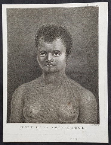
1778 Capt. Cook Antique Print Portrait of a Woman of New Caledonia Visit in 1774
- Title : Femme de la Noule. Caledonie
- Ref : 21327
- Size: 10in x 8in (255mm x 205mm)
- Date : 1778
- Condition: (A+) Fine Condition
Description:
This fine original copper-plate engraved antique print, portrait of a Woman of the Islands of New Caledonia in the South Pacific, visited by Captain James Cook during his 2nd Voyage of Discovery in the South Seas in September 1774, was engraved by Robert Benard - after William Hodges - and was published in the 1778 French edition of Capt. James Cooks 2nd Voyage of Discovery to the South Seas A voyage towards the South Pole, and round the World. Performed in His Majestys ships the Resolution and Adventure, in the years 1772, 1773, 1774, and 1775..... Paris : Hotel de Thou ......1778
Cook Diary, 4-13th Sep. 1774
4th Sun. Sights Cape Colnett (New Caledonia).
5th Mon. Enters reef (Amoss Passage) between Cook Reef and Balade Reef, anchors off Observatory Isle (Pudiu), visited by inhabitants.
6th Tue. Goes ashore with armed boats, rows along coast, returns to ship. Visited by natives, meets Chief, Teeabooma. Wales and Pickersgill land on Isle, Cook goes to help. Observatory set up for eclipse of Sun.
7th Wed. Eclipse, cloudy at first, observations made. Returns to ship, goes ashore again and returns. Simon Monk, ship’s butcher, dies after fall down fore-hatchway previous night.
8th Thu. Goes ashore. Excursion to west. The Forsters and Cook are ill with eating poisoned fish, liver and roe (Toadfish).
9th Fri. Exchanges presents with Teeabooma but still indisposed.
10th Sat. Forster ashore botanising.
12th Mon. Cutter is damaged when Gilbert and Pickersgill are returning from a visit to the north-west of island. Repairs made.
13th Tue. Takes possession of island in name of King George III, naming it New Caledonia. Sails back through reef and heads NW. along coast, outside Cook Reef, passes Great False Passage.
General Definitions:
Paper thickness and quality: - Heavy and stable
Paper color : - off white
Age of map color: -
Colors used: -
General color appearance: -
Paper size: - 10in x 8in (255mm x 205mm)
Plate size: - 9 1/2in x 7 1/4in (240mm x 185mm)
Margins: - Min 1/2in (12mm)
Imperfections:
Margins: - Light soiling in margins
Plate area: - None
Verso: - None
Background:
New Caledonia is a special collective of France in the southwest Pacific Ocean, 1,210 km east of Australia and 20,000 km from Metropolitan France. The archipelago, part of the Melanesia sub-region, includes the main island of Grande Terre, the Loyalty Islands, the Chesterfield Islands, the Belep archipelago, the Isle of Pines, and a few remote islets. The Chesterfield Islands are in the Coral Sea. Locals refer to Grande Terre as Le Caillou (the pebble)
British explorer Captain James Cook was the first European to sight New Caledonia, on 4 September 1774, during his second voyage. He named it New Caledonia, as the northeast of the island reminded him of Scotland. The west coast of Grande Terre was approached by Jean-François de Galaup, comte de Lapérouse in 1788, shortly before his disappearance, and the Loyalty Islands were first visited between 1793 and 1796 when Mare, Lifou, Tiga, and Ouvea were mapped by William Raven. The American whaler encountered the island named then Britania, and today known as Mar (Loyalty Is.) in November 1793. From 1796 until 1840, only a few sporadic contacts with the archipelago were recorded. About fifty American whalers (identified by Robert Langsom from their log books) have been recorded in the region (Grande Terre, Loyalty Is., Walpole and Hunter) between 1793 and 1887. Contacts became more frequent after 1840, because of the interest in sandalwood
William Hodges RA 1744 – 1797 was an English painter. He was a member of James Cooks second voyage to the Pacific Ocean, and is best known for the sketches and paintings of locations he visited on that voyage, including Table Bay, Tahiti, Easter Island, and the Antarctic.
Between 1772 and 1775 Hodges accompanied James Cook to the Pacific as the expeditions artist. Many of his sketches and wash paintings were adapted as engravings in the original published edition of Cooks journals from the voyage.
Most of the large-scale landscape oil paintings from his Pacific travels for which Hodges is best known were finished after his return to London; he received a salary from the Admiralty for the purposes of completing them. These paintings depicted a stronger light and shadow than had been usual in European landscape tradition. Contemporary art critics complained that his use of light and colour contrasts gave his paintings a rough and unfinished appearance.
Hodges also produced many valuable portrait sketches of Pacific islanders and scenes from the voyage involving members of the expedition..
Robert Bénard 1734 – 1777 was an 18th-century French engraver.
Specialized in the technique of engraving, Robert Ménard is mainly famous for having supplied a significant amount of plates (at least 1,800) to the Encyclopédie by Diderot & d\'Alembert from 1751.
Later, publisher Charles-Joseph Panckoucke reused many of his productions to illustrate the works of his catalog.
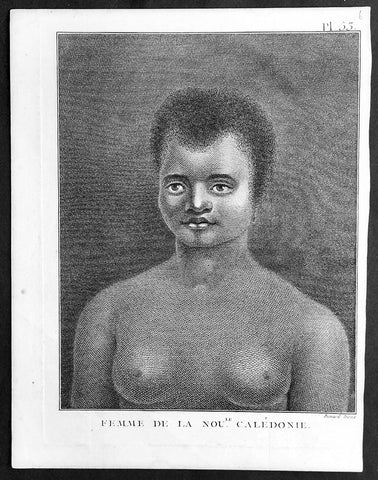
1778 Capt. Cook Antique Print Portrait of a Woman of New Caledonia Visit in 1774
- Title : Femme de la Noule. Caledonie
- Ref : 91210
- Size: 10in x 8in (255mm x 205mm)
- Date : 1778
- Condition: (A+) Fine Condition
Description:
This fine original copper-plate engraved antique print, portrait of a Woman of the Islands of New Caledonia in the South Pacific, visited by Captain James Cook during his 2nd Voyage of Discovery in the South Seas in September 1774, was engraved by Robert Benard - after William Hodges - and was published in the 1778 French edition of Capt. James Cooks 2nd Voyage of Discovery to the South Seas A voyage towards the South Pole, and round the World. Performed in His Majestys ships the Resolution and Adventure, in the years 1772, 1773, 1774, and 1775..... Paris : Hotel de Thou ......1778
Cook Diary, 4-13th Sep. 1774
4th Sun. Sights Cape Colnett (New Caledonia).
5th Mon. Enters reef (Amoss Passage) between Cook Reef and Balade Reef, anchors off Observatory Isle (Pudiu), visited by inhabitants.
6th Tue. Goes ashore with armed boats, rows along coast, returns to ship. Visited by natives, meets Chief, Teeabooma. Wales and Pickersgill land on Isle, Cook goes to help. Observatory set up for eclipse of Sun.
7th Wed. Eclipse, cloudy at first, observations made. Returns to ship, goes ashore again and returns. Simon Monk, ship’s butcher, dies after fall down fore-hatchway previous night.
8th Thu. Goes ashore. Excursion to west. The Forsters and Cook are ill with eating poisoned fish, liver and roe (Toadfish).
9th Fri. Exchanges presents with Teeabooma but still indisposed.
10th Sat. Forster ashore botanising.
12th Mon. Cutter is damaged when Gilbert and Pickersgill are returning from a visit to the north-west of island. Repairs made.
13th Tue. Takes possession of island in name of King George III, naming it New Caledonia. Sails back through reef and heads NW. along coast, outside Cook Reef, passes Great False Passage.
General Definitions:
Paper thickness and quality: - Heavy and stable
Paper color : - off white
Age of map color: -
Colors used: -
General color appearance: -
Paper size: - 10in x 8in (255mm x 205mm)
Plate size: - 9 1/2in x 7 1/4in (240mm x 185mm)
Margins: - Min 1/2in (12mm)
Imperfections:
Margins: - Light soiling in margins
Plate area: - None
Verso: - None
Background:
New Caledonia is a special collective of France in the southwest Pacific Ocean, 1,210 km east of Australia and 20,000 km from Metropolitan France. The archipelago, part of the Melanesia sub-region, includes the main island of Grande Terre, the Loyalty Islands, the Chesterfield Islands, the Belep archipelago, the Isle of Pines, and a few remote islets. The Chesterfield Islands are in the Coral Sea. Locals refer to Grande Terre as Le Caillou (the pebble)
British explorer Captain James Cook was the first European to sight New Caledonia, on 4 September 1774, during his second voyage. He named it New Caledonia, as the northeast of the island reminded him of Scotland. The west coast of Grande Terre was approached by Jean-François de Galaup, comte de Lapérouse in 1788, shortly before his disappearance, and the Loyalty Islands were first visited between 1793 and 1796 when Mare, Lifou, Tiga, and Ouvea were mapped by William Raven. The American whaler encountered the island named then Britania, and today known as Mar (Loyalty Is.) in November 1793. From 1796 until 1840, only a few sporadic contacts with the archipelago were recorded. About fifty American whalers (identified by Robert Langsom from their log books) have been recorded in the region (Grande Terre, Loyalty Is., Walpole and Hunter) between 1793 and 1887. Contacts became more frequent after 1840, because of the interest in sandalwood
William Hodges RA 1744 – 1797 was an English painter. He was a member of James Cooks second voyage to the Pacific Ocean, and is best known for the sketches and paintings of locations he visited on that voyage, including Table Bay, Tahiti, Easter Island, and the Antarctic.
Between 1772 and 1775 Hodges accompanied James Cook to the Pacific as the expeditions artist. Many of his sketches and wash paintings were adapted as engravings in the original published edition of Cooks journals from the voyage.
Most of the large-scale landscape oil paintings from his Pacific travels for which Hodges is best known were finished after his return to London; he received a salary from the Admiralty for the purposes of completing them. These paintings depicted a stronger light and shadow than had been usual in European landscape tradition. Contemporary art critics complained that his use of light and colour contrasts gave his paintings a rough and unfinished appearance.
Hodges also produced many valuable portrait sketches of Pacific islanders and scenes from the voyage involving members of the expedition..
Robert Bénard 1734 – 1777 was an 18th-century French engraver.
Specialized in the technique of engraving, Robert Ménard is mainly famous for having supplied a significant amount of plates (at least 1,800) to the Encyclopédie by Diderot & d\'Alembert from 1751.
Later, publisher Charles-Joseph Panckoucke reused many of his productions to illustrate the works of his catalog.
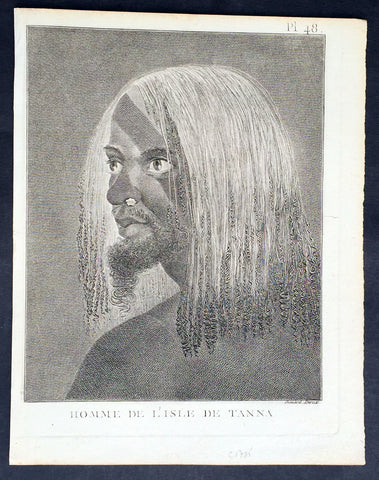
1778 Capt. Cook Antique Print of a Man of the Tanna Island, Vanuatu in 1774
- Title : Homme De L Isle de Tanna
- Ref : 21353
- Size: 10in x 8in (255mm x 205mm)
- Date : 1778
- Condition: (A+) Fine Condition
Description:
This fine original copper-plate engraved antique print, a portrait of a Man of the Island of Tanna in the Vanuatu group of Islands in the South Pacific, visited by Captain James Cook during his 2nd Voyage of Discovery in the South Seas in 1774, was engraved by Robert Benard - after William Hodges - and was published in the 1778 French edition of Capt. James Cooks 2nd Voyage of Discovery to the South Seas A voyage towards the South Pole, and round the World. Performed in His Majestys ships the Resolution and Adventure, in the years 1772, 1773, 1774, and 1775..... Paris : Hotel de Thou ......1778
Cook Diary, 6-20th August 1774
........the Women have all the same ornaments as Men, Nose-Stones, Earrings, Shells on the Breast & Bracelets...their heads covered with a kind of cap made of a Plantain leaf or a Mat-Basket. Few are covered, & even very young Girls have these Caps.......Cooks Journal II
General Definitions:
Paper thickness and quality: - Heavy and stable
Paper color : - off white
Age of map color: -
Colors used: -
General color appearance: -
Paper size: - 10in x 8in (255mm x 205mm)
Plate size: - 9 1/2in x 7 1/4in (240mm x 185mm)
Margins: - Min 1/2in (12mm)
Imperfections:
Margins: - Light soiling in margins
Plate area: - None
Verso: - None
Background:
Tanna (sometimes spelled Tana) is an island in Tafea Province of Vanuatu.
Tanna was first settled about 400 BC by Melanesians from the surrounding islands. The glowing light of Mount Yasur attracted James Cook, the first European to visit the island, in August 1774, where he landed in an inlet on the southeastern tip of the island that he named Port Resolution after his ship HMS Resolution. He gave the island the name of Tanna, probably from the local name for earth, tana in the Kwamera language.
Vanuatu is a Pacific island nation located in the South Pacific Ocean. The archipelago, which is of volcanic origin, is 1,750 kilometres east of northern Australia, 540 kilometres northeast of New Caledonia, east of New Guinea, southeast of the Solomon Islands, and west of Fiji.
The Vanuatu group of islands first had contact with Europeans in 1606, when the Portuguese explorer Pedro Fernandes de Queirós, sailing for the Spanish Crown, arrived on the largest island and called the group of islands La Austrialia del Espiritu Santo or The Southern Land of the Holy Spirit, believing he had arrived in Terra Australis or Australia. The Spanish established a short-lived settlement at Big Bay on the north side of the island. The name Espiritu Santo remains to this day.
Europeans did not return until 1768, when Louis Antoine de Bougainville rediscovered the islands on 22 May, naming them the Great Cyclades. In 1774, Captain Cook named the islands the New Hebrides, a name that would last until independence in 1980.
William Hodges RA 1744 – 1797 was an English painter. He was a member of James Cooks second voyage to the Pacific Ocean, and is best known for the sketches and paintings of locations he visited on that voyage, including Table Bay, Tahiti, Easter Island, and the Antarctic.
Between 1772 and 1775 Hodges accompanied James Cook to the Pacific as the expeditions artist. Many of his sketches and wash paintings were adapted as engravings in the original published edition of Cooks journals from the voyage.
Most of the large-scale landscape oil paintings from his Pacific travels for which Hodges is best known were finished after his return to London; he received a salary from the Admiralty for the purposes of completing them. These paintings depicted a stronger light and shadow than had been usual in European landscape tradition. Contemporary art critics complained that his use of light and colour contrasts gave his paintings a rough and unfinished appearance.
Hodges also produced many valuable portrait sketches of Pacific islanders and scenes from the voyage involving members of the expedition..
Robert Bénard 1734 – 1777 was an 18th-century French engraver.
Specialized in the technique of engraving, Robert Ménard is mainly famous for having supplied a significant amount of plates (at least 1,800) to the Encyclopédie by Diderot & d\'Alembert from 1751.
Later, publisher Charles-Joseph Panckoucke reused many of his productions to illustrate the works of his catalog.
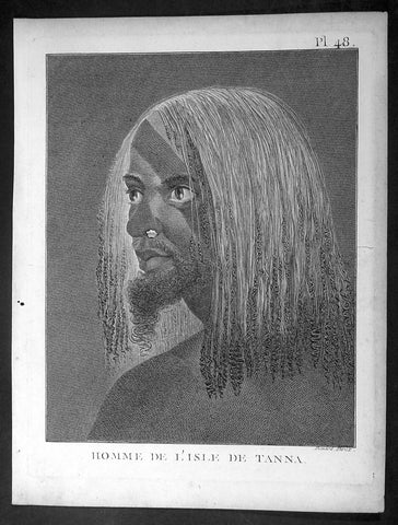
1778 Capt. Cook Antique Print of a Man of the Tanna Island, Vanuatu in 1774
- Title : Homme De L Isle de Tanna
- Ref : 16344-1
- Size: 10in x 8in (255mm x 205mm)
- Date : 1778
- Condition: (A+) Fine Condition
Description:
This fine original copper-plate engraved antique print, a portrait of a Man of the Island of Tanna in the Vanuatu group of Islands in the South Pacific, visited by Captain James Cook during his 2nd Voyage of Discovery in the South Seas in 1774, was engraved by Robert Benard - after William Hodges - and was published in the 1778 French edition of Capt. James Cooks 2nd Voyage of Discovery to the South Seas A voyage towards the South Pole, and round the World. Performed in His Majestys ships the Resolution and Adventure, in the years 1772, 1773, 1774, and 1775..... Paris : Hotel de Thou ......1778
Cook Diary, 6-20th August 1774
........the Women have all the same ornaments as Men, Nose-Stones, Earrings, Shells on the Breast & Bracelets...their heads covered with a kind of cap made of a Plantain leaf or a Mat-Basket. Few are covered, & even very young Girls have these Caps.......Cooks Journal II
General Definitions:
Paper thickness and quality: - Heavy and stable
Paper color : - off white
Age of map color: -
Colors used: -
General color appearance: -
Paper size: - 10in x 8in (255mm x 205mm)
Plate size: - 9 1/2in x 7 1/4in (240mm x 185mm)
Margins: - Min 1/2in (12mm)
Imperfections:
Margins: - Light soiling in margins
Plate area: - None
Verso: - None
Background:
Tanna (sometimes spelled Tana) is an island in Tafea Province of Vanuatu.
Tanna was first settled about 400 BC by Melanesians from the surrounding islands. The glowing light of Mount Yasur attracted James Cook, the first European to visit the island, in August 1774, where he landed in an inlet on the southeastern tip of the island that he named Port Resolution after his ship HMS Resolution. He gave the island the name of Tanna, probably from the local name for earth, tana in the Kwamera language.
Vanuatu is a Pacific island nation located in the South Pacific Ocean. The archipelago, which is of volcanic origin, is 1,750 kilometres east of northern Australia, 540 kilometres northeast of New Caledonia, east of New Guinea, southeast of the Solomon Islands, and west of Fiji.
The Vanuatu group of islands first had contact with Europeans in 1606, when the Portuguese explorer Pedro Fernandes de Queirós, sailing for the Spanish Crown, arrived on the largest island and called the group of islands La Austrialia del Espiritu Santo or The Southern Land of the Holy Spirit, believing he had arrived in Terra Australis or Australia. The Spanish established a short-lived settlement at Big Bay on the north side of the island. The name Espiritu Santo remains to this day.
Europeans did not return until 1768, when Louis Antoine de Bougainville rediscovered the islands on 22 May, naming them the Great Cyclades. In 1774, Captain Cook named the islands the New Hebrides, a name that would last until independence in 1980.
William Hodges RA 1744 – 1797 was an English painter. He was a member of James Cooks second voyage to the Pacific Ocean, and is best known for the sketches and paintings of locations he visited on that voyage, including Table Bay, Tahiti, Easter Island, and the Antarctic.
Between 1772 and 1775 Hodges accompanied James Cook to the Pacific as the expeditions artist. Many of his sketches and wash paintings were adapted as engravings in the original published edition of Cooks journals from the voyage.
Most of the large-scale landscape oil paintings from his Pacific travels for which Hodges is best known were finished after his return to London; he received a salary from the Admiralty for the purposes of completing them. These paintings depicted a stronger light and shadow than had been usual in European landscape tradition. Contemporary art critics complained that his use of light and colour contrasts gave his paintings a rough and unfinished appearance.
Hodges also produced many valuable portrait sketches of Pacific islanders and scenes from the voyage involving members of the expedition..
Robert Bénard 1734 – 1777 was an 18th-century French engraver.
Specialized in the technique of engraving, Robert Ménard is mainly famous for having supplied a significant amount of plates (at least 1,800) to the Encyclopédie by Diderot & d\'Alembert from 1751.
Later, publisher Charles-Joseph Panckoucke reused many of his productions to illustrate the works of his catalog.
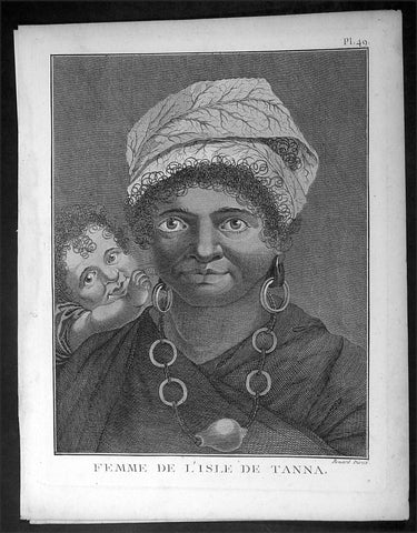
1778 Capt. Cook Antique Print Portrait of a Woman of Tanna Isle, Vanuatu in 1774
- Title : Femme De L Isle de Tanna
- Ref : 16354
- Size: 10in x 8in (255mm x 205mm)
- Date : 1778
- Condition: (A+) Fine Condition
Description:
This fine original copper-plate engraved antique print, a portrait of a Woman & Child of the Island of Tanna in the Vanuatu group of Islands in the South Pacific, visited by Captain James Cook during his 2nd Voyage of Discovery in the South Seas in 1774, was engraved by Robert Benard - after William Hodges - and was published in the 1778 French edition of Capt. James Cooks 2nd Voyage of Discovery to the South Seas A voyage towards the South Pole, and round the World. Performed in His Majestys ships the Resolution and Adventure, in the years 1772, 1773, 1774, and 1775..... Paris : Hotel de Thou ......1778
Cook Diary, 6-20th August 1774
........the Women have all the same ornaments as Men, Nose-Stones, Earrings, Shells on the Breast & Bracelets...their heads covered with a kind of cap made of a Plantain leaf or a Mat-Basket. Few are covered, & even very young Girls have these Caps.......Cooks Journal II
General Definitions:
Paper thickness and quality: - Heavy and stable
Paper color : - off white
Age of map color: -
Colors used: -
General color appearance: -
Paper size: - 10in x 8in (255mm x 205mm)
Plate size: - 9 1/2in x 7 1/4in (240mm x 185mm)
Margins: - Min 1/2in (12mm)
Imperfections:
Margins: - Light soiling in margins
Plate area: - None
Verso: - None
Background:
Tanna (sometimes spelled Tana) is an island in Tafea Province of Vanuatu.
Tanna was first settled about 400 BC by Melanesians from the surrounding islands. The glowing light of Mount Yasur attracted James Cook, the first European to visit the island, in August 1774, where he landed in an inlet on the southeastern tip of the island that he named Port Resolution after his ship HMS Resolution. He gave the island the name of Tanna, probably from the local name for earth, tana in the Kwamera language.
Vanuatu is a Pacific island nation located in the South Pacific Ocean. The archipelago, which is of volcanic origin, is 1,750 kilometres east of northern Australia, 540 kilometres northeast of New Caledonia, east of New Guinea, southeast of the Solomon Islands, and west of Fiji.
The Vanuatu group of islands first had contact with Europeans in 1606, when the Portuguese explorer Pedro Fernandes de Queirós, sailing for the Spanish Crown, arrived on the largest island and called the group of islands La Austrialia del Espiritu Santo or The Southern Land of the Holy Spirit, believing he had arrived in Terra Australis or Australia. The Spanish established a short-lived settlement at Big Bay on the north side of the island. The name Espiritu Santo remains to this day.
Europeans did not return until 1768, when Louis Antoine de Bougainville rediscovered the islands on 22 May, naming them the Great Cyclades. In 1774, Captain Cook named the islands the New Hebrides, a name that would last until independence in 1980.
William Hodges RA 1744 – 1797 was an English painter. He was a member of James Cooks second voyage to the Pacific Ocean, and is best known for the sketches and paintings of locations he visited on that voyage, including Table Bay, Tahiti, Easter Island, and the Antarctic.
Between 1772 and 1775 Hodges accompanied James Cook to the Pacific as the expeditions artist. Many of his sketches and wash paintings were adapted as engravings in the original published edition of Cooks journals from the voyage.
Most of the large-scale landscape oil paintings from his Pacific travels for which Hodges is best known were finished after his return to London; he received a salary from the Admiralty for the purposes of completing them. These paintings depicted a stronger light and shadow than had been usual in European landscape tradition. Contemporary art critics complained that his use of light and colour contrasts gave his paintings a rough and unfinished appearance.
Hodges also produced many valuable portrait sketches of Pacific islanders and scenes from the voyage involving members of the expedition..
Robert Bénard 1734 – 1777 was an 18th-century French engraver.
Specialized in the technique of engraving, Robert Ménard is mainly famous for having supplied a significant amount of plates (at least 1,800) to the Encyclopédie by Diderot & d\'Alembert from 1751.
Later, publisher Charles-Joseph Panckoucke reused many of his productions to illustrate the works of his catalog.
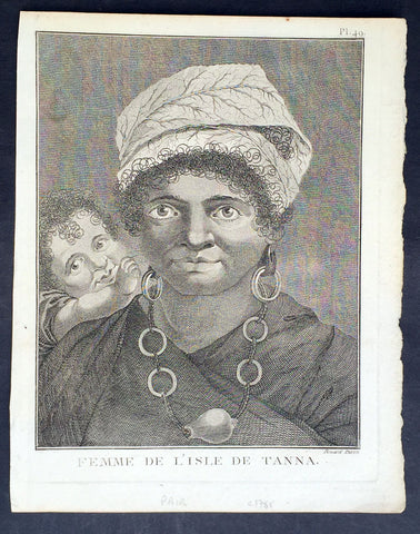
1778 Capt. Cook Antique Print Portrait of a Woman of Tanna Isle, Vanuatu in 1774
- Title : Femme De L Isle de Tanna
- Ref : 21354
- Size: 10in x 8in (255mm x 205mm)
- Date : 1778
- Condition: (A+) Fine Condition
Description:
This fine original copper-plate engraved antique print, a portrait of a Woman & Child of the Island of Tanna in the Vanuatu group of Islands in the South Pacific, visited by Captain James Cook during his 2nd Voyage of Discovery in the South Seas in 1774, was engraved by Robert Benard - after William Hodges - and was published in the 1778 French edition of Capt. James Cooks 2nd Voyage of Discovery to the South Seas A voyage towards the South Pole, and round the World. Performed in His Majestys ships the Resolution and Adventure, in the years 1772, 1773, 1774, and 1775..... Paris : Hotel de Thou ......1778
Cook Diary, 6-20th August 1774
........the Women have all the same ornaments as Men, Nose-Stones, Earrings, Shells on the Breast & Bracelets...their heads covered with a kind of cap made of a Plantain leaf or a Mat-Basket. Few are covered, & even very young Girls have these Caps.......Cooks Journal II
General Definitions:
Paper thickness and quality: - Heavy and stable
Paper color : - off white
Age of map color: -
Colors used: -
General color appearance: -
Paper size: - 10in x 8in (255mm x 205mm)
Plate size: - 9 1/2in x 7 1/4in (240mm x 185mm)
Margins: - Min 1/2in (12mm)
Imperfections:
Margins: - Light soiling in margins
Plate area: - None
Verso: - None
Background:
Tanna (sometimes spelled Tana) is an island in Tafea Province of Vanuatu.
Tanna was first settled about 400 BC by Melanesians from the surrounding islands. The glowing light of Mount Yasur attracted James Cook, the first European to visit the island, in August 1774, where he landed in an inlet on the southeastern tip of the island that he named Port Resolution after his ship HMS Resolution. He gave the island the name of Tanna, probably from the local name for earth, tana in the Kwamera language.
Vanuatu is a Pacific island nation located in the South Pacific Ocean. The archipelago, which is of volcanic origin, is 1,750 kilometres east of northern Australia, 540 kilometres northeast of New Caledonia, east of New Guinea, southeast of the Solomon Islands, and west of Fiji.
The Vanuatu group of islands first had contact with Europeans in 1606, when the Portuguese explorer Pedro Fernandes de Queirós, sailing for the Spanish Crown, arrived on the largest island and called the group of islands La Austrialia del Espiritu Santo or The Southern Land of the Holy Spirit, believing he had arrived in Terra Australis or Australia. The Spanish established a short-lived settlement at Big Bay on the north side of the island. The name Espiritu Santo remains to this day.
Europeans did not return until 1768, when Louis Antoine de Bougainville rediscovered the islands on 22 May, naming them the Great Cyclades. In 1774, Captain Cook named the islands the New Hebrides, a name that would last until independence in 1980.
William Hodges RA 1744 – 1797 was an English painter. He was a member of James Cooks second voyage to the Pacific Ocean, and is best known for the sketches and paintings of locations he visited on that voyage, including Table Bay, Tahiti, Easter Island, and the Antarctic.
Between 1772 and 1775 Hodges accompanied James Cook to the Pacific as the expeditions artist. Many of his sketches and wash paintings were adapted as engravings in the original published edition of Cooks journals from the voyage.
Most of the large-scale landscape oil paintings from his Pacific travels for which Hodges is best known were finished after his return to London; he received a salary from the Admiralty for the purposes of completing them. These paintings depicted a stronger light and shadow than had been usual in European landscape tradition. Contemporary art critics complained that his use of light and colour contrasts gave his paintings a rough and unfinished appearance.
Hodges also produced many valuable portrait sketches of Pacific islanders and scenes from the voyage involving members of the expedition..
Robert Bénard 1734 – 1777 was an 18th-century French engraver.
Specialized in the technique of engraving, Robert Ménard is mainly famous for having supplied a significant amount of plates (at least 1,800) to the Encyclopédie by Diderot & d\'Alembert from 1751.
Later, publisher Charles-Joseph Panckoucke reused many of his productions to illustrate the works of his catalog.
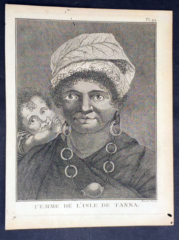
1778 Capt. Cook Antique Print Portrait of a Woman of Tanna Isle, Vanuatu in 1774
- Title : Femme De L Isle de Tanna
- Ref : 31782
- Size: 10in x 8in (255mm x 205mm)
- Date : 1778
- Condition: (A+) Fine Condition
Description:
This fine original copper-plate engraved antique print, a portrait of a Woman & Child of the Island of Tanna in the Vanuatu group of Islands in the South Pacific, visited by Captain James Cook during his 2nd Voyage of Discovery in the South Seas in 1774, was engraved by Robert Benard - after William Hodges - and was published in the 1778 French edition of Capt. James Cooks 2nd Voyage of Discovery to the South Seas A voyage towards the South Pole, and round the World. Performed in His Majestys ships the Resolution and Adventure, in the years 1772, 1773, 1774, and 1775..... Paris : Hotel de Thou ......1778
Cook Diary, 6-20th August 1774
........the Women have all the same ornaments as Men, Nose-Stones, Earrings, Shells on the Breast & Bracelets...their heads covered with a kind of cap made of a Plantain leaf or a Mat-Basket. Few are covered, & even very young Girls have these Caps.......Cooks Journal II
General Definitions:
Paper thickness and quality: - Heavy and stable
Paper color : - off white
Age of map color: -
Colors used: -
General color appearance: -
Paper size: - 10in x 8in (255mm x 205mm)
Plate size: - 9 1/2in x 7 1/4in (240mm x 185mm)
Margins: - Min 1/2in (12mm)
Imperfections:
Margins: - Light soiling in margins
Plate area: - None
Verso: - None
Background:
Tanna (sometimes spelled Tana) is an island in Tafea Province of Vanuatu.
Tanna was first settled about 400 BC by Melanesians from the surrounding islands. The glowing light of Mount Yasur attracted James Cook, the first European to visit the island, in August 1774, where he landed in an inlet on the southeastern tip of the island that he named Port Resolution after his ship HMS Resolution. He gave the island the name of Tanna, probably from the local name for earth, tana in the Kwamera language.
Vanuatu is a Pacific island nation located in the South Pacific Ocean. The archipelago, which is of volcanic origin, is 1,750 kilometres east of northern Australia, 540 kilometres northeast of New Caledonia, east of New Guinea, southeast of the Solomon Islands, and west of Fiji.
The Vanuatu group of islands first had contact with Europeans in 1606, when the Portuguese explorer Pedro Fernandes de Queirós, sailing for the Spanish Crown, arrived on the largest island and called the group of islands La Austrialia del Espiritu Santo or The Southern Land of the Holy Spirit, believing he had arrived in Terra Australis or Australia. The Spanish established a short-lived settlement at Big Bay on the north side of the island. The name Espiritu Santo remains to this day.
Europeans did not return until 1768, when Louis Antoine de Bougainville rediscovered the islands on 22 May, naming them the Great Cyclades. In 1774, Captain Cook named the islands the New Hebrides, a name that would last until independence in 1980.
William Hodges RA 1744 – 1797 was an English painter. He was a member of James Cooks second voyage to the Pacific Ocean, and is best known for the sketches and paintings of locations he visited on that voyage, including Table Bay, Tahiti, Easter Island, and the Antarctic.
Between 1772 and 1775 Hodges accompanied James Cook to the Pacific as the expeditions artist. Many of his sketches and wash paintings were adapted as engravings in the original published edition of Cooks journals from the voyage.
Most of the large-scale landscape oil paintings from his Pacific travels for which Hodges is best known were finished after his return to London; he received a salary from the Admiralty for the purposes of completing them. These paintings depicted a stronger light and shadow than had been usual in European landscape tradition. Contemporary art critics complained that his use of light and colour contrasts gave his paintings a rough and unfinished appearance.
Hodges also produced many valuable portrait sketches of Pacific islanders and scenes from the voyage involving members of the expedition..
Robert Bénard 1734 – 1777 was an 18th-century French engraver.
Specialized in the technique of engraving, Robert Ménard is mainly famous for having supplied a significant amount of plates (at least 1,800) to the Encyclopédie by Diderot & d\'Alembert from 1751.
Later, publisher Charles-Joseph Panckoucke reused many of his productions to illustrate the works of his catalog.
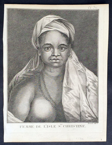
1778 Capt Cook Antique Print Portrait Princess of Tahuata, Marquesas Isles, 1774
- Title : Femme De L Isle de Ste. Christine
- Ref : 21399
- Size: 10in x 8in (255mm x 205mm)
- Date : 1778
- Condition: (A+) Fine Condition
Description:
This fine original copper-plate engraved antique print, a portrait of a Princess of Tahuata Island, Santa Cristina, in the Marquesas Islands, South Pacific, visited by Captain James Cook during his 2nd Voyage of Discovery in the South Seas in 1774, was engraved by Robert Benard - after William Hodges - and was published in the 1778 French edition of Capt. James Cooks 2nd Voyage of Discovery to the South Seas A voyage towards the South Pole, and round the World. Performed in His Majestys ships the Resolution and Adventure, in the years 1772, 1773, 1774, and 1775..... Paris : Hotel de Thou ......1778
Cook Diary (1774)
Apr. 7 Thu. Sights Hood’s Island (Fatu Huku), St. Pedro (Motare). La Dominica (Hiva Oa), St. Christina (Tahuata).
Apr 8 Fri. Sails along southern coast of Hiva Oa looking for anchorage. Anchors in Resolution (formerly Madre de Dios) Bay (Vaitahu Bay). Canoes arrive, gifts are exchanged. Natives killed after an iron stanchion is stolen.
Apr 9 Sat. Goes ashore, gifts exchanged, food obtained.
Apr 10 Sun. Goes ashore to south end of Bay and visits house of dead man. Gifts exchanged.
Apr 11 Mon. Goes ashore to south, again. Finds trade becoming expensive because of lavish gifts by his “gentlemen”.
Apr 12 Tue. Sails towards St. Dominica. No anchorage visible. Heads SW away from islands.
Apr 13 Wed. Sights last of the five main islands, Magdalena (Fatu Hiva).
General Definitions:
Paper thickness and quality: - Heavy and stable
Paper color : - off white
Age of map color: -
Colors used: -
General color appearance: -
Paper size: - 10in x 8in (255mm x 205mm)
Plate size: - 9 1/2in x 7 1/4in (240mm x 185mm)
Margins: - Min 1/2in (12mm)
Imperfections:
Margins: - Light soiling in margins
Plate area: - None
Verso: - None
Background:
Tahuata is the smallest of the inhabited Marquesas Islands, in French Polynesia, an overseas territory of France in the Pacific Ocean.
The first recorded sighting by Europeans was by the Spanish expedition of Álvaro de Mandaña on 22 July 1595. They charted the island as Santa Cristina. They landed at Vaitahu that they named Madre de Dios (Gods Mother in Spanish). According to the Spanish accounts Tahuata had fowls, fish, sugar cane, plantains, nuts and fruits. The existent town was built on two sides of a rectangular space, the houses being of timber and intertwined canes. A building which the Spaniards supposed to be a religious one stood outside the town, in a space enclosed by palisades, and containing some ill-carved images before which were offerings and provisions. The people had large and well constructed sailing canoes. Their tools were made of shells and fish bones. They used slings, stones, and lances as weapons.
Tahuata was visited by Captain James Cook in 1774 and Admiral Dupetit-Thouars in 1842, who signed the treaty annexing the Marquesas Islands to France.
The Marquesas Islands are a group of volcanic islands in French Polynesia, an overseas collective of France in the southern Pacific Ocean.
The first Europeans to reach the Marquesas may have been the crew of San Lesmes, a Spanish vessel which disappeared in a storm in June 1526; it was part of an expedition headed by García Jofre de Loaísa. The Spanish explorer Álvaro de Mendaña reached them seventy years later on 21 July 1595. He named them after his patron, García Hurtado de Mendoza, 5th Marquis of Cañete (Spanish: Marqués de Cañete), who served as Viceroy of Peru from 1590 to 1596. |Mendaña visited first Fatu Hiva and then Tahuata before continuing on to the Solomon Islands. His expedition charted the four southernmost Marquesas as Magdalena (Fatu Hiva), Dominica (Hiva ʻOa), San Pedro (Moho Tani), and Santa Cristina (Tahuata).
In the late 16th century European explorers estimated the population at more than 100,000. Europeans and Americans were impressed with how easy life appeared to be in the islands, which had a rich habitat and environment. In 1791 the American maritime fur trader Joseph Ingraham first visited the northern Marquesas while commanding the brig Hope. He named them the Washington Islands. In 1813 Commodore David Porter claimed Nuku Hiva for the United States, but the United States Congress never ratified that claim.
In 1842 France conducted a successful military operation on behalf of the native chief Iotete, who claimed he was king of the whole island of Tahuata. The government laid claim to the whole group and established a settlement on Nuku Hiva. That settlement was abandoned in 1857, but France re-established control over the group in 1870. It later incorporated the Marquesas into French Polynesia.
William Hodges RA 1744 – 1797 was an English painter. He was a member of James Cooks second voyage to the Pacific Ocean, and is best known for the sketches and paintings of locations he visited on that voyage, including Table Bay, Tahiti, Easter Island, and the Antarctic.
Between 1772 and 1775 Hodges accompanied James Cook to the Pacific as the expeditions artist. Many of his sketches and wash paintings were adapted as engravings in the original published edition of Cooks journals from the voyage.
Most of the large-scale landscape oil paintings from his Pacific travels for which Hodges is best known were finished after his return to London; he received a salary from the Admiralty for the purposes of completing them. These paintings depicted a stronger light and shadow than had been usual in European landscape tradition. Contemporary art critics complained that his use of light and colour contrasts gave his paintings a rough and unfinished appearance.
Hodges also produced many valuable portrait sketches of Pacific islanders and scenes from the voyage involving members of the expedition..
Robert Bénard 1734 – 1777 was an 18th-century French engraver.
Specialized in the technique of engraving, Robert Ménard is mainly famous for having supplied a significant amount of plates (at least 1,800) to the Encyclopédie by Diderot & d\'Alembert from 1751.
Later, publisher Charles-Joseph Panckoucke reused many of his productions to illustrate the works of his catalog.
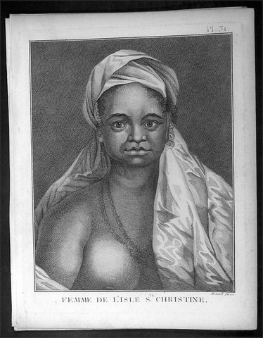
1778 Capt Cook Antique Print Portrait Princess of Tahuata, Marquesas Isles, 1774
- Title : Femme De L Isle de Ste. Christine
- Ref : 16349
- Size: 10in x 8in (255mm x 205mm)
- Date : 1778
- Condition: (A+) Fine Condition
Description:
This fine original copper-plate engraved antique print, a portrait of a Princess of Tahuata Island, Santa Cristina, in the Marquesas Islands, South Pacific, visited by Captain James Cook during his 2nd Voyage of Discovery in the South Seas in 1774, was engraved by Robert Benard - after William Hodges - and was published in the 1778 French edition of Capt. James Cooks 2nd Voyage of Discovery to the South Seas A voyage towards the South Pole, and round the World. Performed in His Majestys ships the Resolution and Adventure, in the years 1772, 1773, 1774, and 1775..... Paris : Hotel de Thou ......1778
Cook Diary (1774)
Apr. 7 Thu. Sights Hood’s Island (Fatu Huku), St. Pedro (Motare). La Dominica (Hiva Oa), St. Christina (Tahuata).
Apr 8 Fri. Sails along southern coast of Hiva Oa looking for anchorage. Anchors in Resolution (formerly Madre de Dios) Bay (Vaitahu Bay). Canoes arrive, gifts are exchanged. Natives killed after an iron stanchion is stolen.
Apr 9 Sat. Goes ashore, gifts exchanged, food obtained.
Apr 10 Sun. Goes ashore to south end of Bay and visits house of dead man. Gifts exchanged.
Apr 11 Mon. Goes ashore to south, again. Finds trade becoming expensive because of lavish gifts by his “gentlemen”.
Apr 12 Tue. Sails towards St. Dominica. No anchorage visible. Heads SW away from islands.
Apr 13 Wed. Sights last of the five main islands, Magdalena (Fatu Hiva).
General Definitions:
Paper thickness and quality: - Heavy and stable
Paper color : - off white
Age of map color: -
Colors used: -
General color appearance: -
Paper size: - 10in x 8in (255mm x 205mm)
Plate size: - 9 1/2in x 7 1/4in (240mm x 185mm)
Margins: - Min 1/2in (12mm)
Imperfections:
Margins: - Light soiling in margins
Plate area: - None
Verso: - None
Background:
Tahuata is the smallest of the inhabited Marquesas Islands, in French Polynesia, an overseas territory of France in the Pacific Ocean.
The first recorded sighting by Europeans was by the Spanish expedition of Álvaro de Mandaña on 22 July 1595. They charted the island as Santa Cristina. They landed at Vaitahu that they named Madre de Dios (Gods Mother in Spanish). According to the Spanish accounts Tahuata had fowls, fish, sugar cane, plantains, nuts and fruits. The existent town was built on two sides of a rectangular space, the houses being of timber and intertwined canes. A building which the Spaniards supposed to be a religious one stood outside the town, in a space enclosed by palisades, and containing some ill-carved images before which were offerings and provisions. The people had large and well constructed sailing canoes. Their tools were made of shells and fish bones. They used slings, stones, and lances as weapons.
Tahuata was visited by Captain James Cook in 1774 and Admiral Dupetit-Thouars in 1842, who signed the treaty annexing the Marquesas Islands to France.
The Marquesas Islands are a group of volcanic islands in French Polynesia, an overseas collective of France in the southern Pacific Ocean.
The first Europeans to reach the Marquesas may have been the crew of San Lesmes, a Spanish vessel which disappeared in a storm in June 1526; it was part of an expedition headed by García Jofre de Loaísa. The Spanish explorer Álvaro de Mendaña reached them seventy years later on 21 July 1595. He named them after his patron, García Hurtado de Mendoza, 5th Marquis of Cañete (Spanish: Marqués de Cañete), who served as Viceroy of Peru from 1590 to 1596. |Mendaña visited first Fatu Hiva and then Tahuata before continuing on to the Solomon Islands. His expedition charted the four southernmost Marquesas as Magdalena (Fatu Hiva), Dominica (Hiva ʻOa), San Pedro (Moho Tani), and Santa Cristina (Tahuata).
In the late 16th century European explorers estimated the population at more than 100,000. Europeans and Americans were impressed with how easy life appeared to be in the islands, which had a rich habitat and environment. In 1791 the American maritime fur trader Joseph Ingraham first visited the northern Marquesas while commanding the brig Hope. He named them the Washington Islands. In 1813 Commodore David Porter claimed Nuku Hiva for the United States, but the United States Congress never ratified that claim.
In 1842 France conducted a successful military operation on behalf of the native chief Iotete, who claimed he was king of the whole island of Tahuata. The government laid claim to the whole group and established a settlement on Nuku Hiva. That settlement was abandoned in 1857, but France re-established control over the group in 1870. It later incorporated the Marquesas into French Polynesia.
William Hodges RA 1744 – 1797 was an English painter. He was a member of James Cooks second voyage to the Pacific Ocean, and is best known for the sketches and paintings of locations he visited on that voyage, including Table Bay, Tahiti, Easter Island, and the Antarctic.
Between 1772 and 1775 Hodges accompanied James Cook to the Pacific as the expeditions artist. Many of his sketches and wash paintings were adapted as engravings in the original published edition of Cooks journals from the voyage.
Most of the large-scale landscape oil paintings from his Pacific travels for which Hodges is best known were finished after his return to London; he received a salary from the Admiralty for the purposes of completing them. These paintings depicted a stronger light and shadow than had been usual in European landscape tradition. Contemporary art critics complained that his use of light and colour contrasts gave his paintings a rough and unfinished appearance.
Hodges also produced many valuable portrait sketches of Pacific islanders and scenes from the voyage involving members of the expedition..
Robert Bénard 1734 – 1777 was an 18th-century French engraver.
Specialized in the technique of engraving, Robert Ménard is mainly famous for having supplied a significant amount of plates (at least 1,800) to the Encyclopédie by Diderot & d\'Alembert from 1751.
Later, publisher Charles-Joseph Panckoucke reused many of his productions to illustrate the works of his catalog.
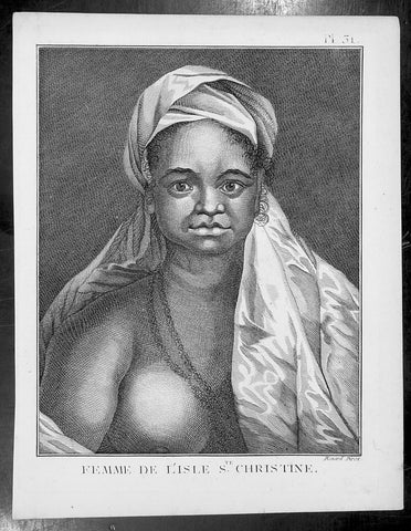
1778 Capt Cook Antique Print Portrait Princess of Tahuata, Marquesas Isles, 1774
- Title : Femme De L Isle de Ste. Christine
- Ref : 31806
- Size: 10in x 8in (255mm x 205mm)
- Date : 1778
- Condition: (A+) Fine Condition
Description:
This fine original copper-plate engraved antique print, a portrait of a Princess of Tahuata Island, Santa Cristina, in the Marquesas Islands, South Pacific, visited by Captain James Cook during his 2nd Voyage of Discovery in the South Seas in 1774, was engraved by Robert Benard - after William Hodges - and was published in the 1778 French edition of Capt. James Cooks 2nd Voyage of Discovery to the South Seas A voyage towards the South Pole, and round the World. Performed in His Majestys ships the Resolution and Adventure, in the years 1772, 1773, 1774, and 1775..... Paris : Hotel de Thou ......1778
Cook Diary (1774)
Apr. 7 Thu. Sights Hood’s Island (Fatu Huku), St. Pedro (Motare). La Dominica (Hiva Oa), St. Christina (Tahuata).
Apr 8 Fri. Sails along southern coast of Hiva Oa looking for anchorage. Anchors in Resolution (formerly Madre de Dios) Bay (Vaitahu Bay). Canoes arrive, gifts are exchanged. Natives killed after an iron stanchion is stolen.
Apr 9 Sat. Goes ashore, gifts exchanged, food obtained.
Apr 10 Sun. Goes ashore to south end of Bay and visits house of dead man. Gifts exchanged.
Apr 11 Mon. Goes ashore to south, again. Finds trade becoming expensive because of lavish gifts by his “gentlemen”.
Apr 12 Tue. Sails towards St. Dominica. No anchorage visible. Heads SW away from islands.
Apr 13 Wed. Sights last of the five main islands, Magdalena (Fatu Hiva).
General Definitions:
Paper thickness and quality: - Heavy and stable
Paper color : - off white
Age of map color: -
Colors used: -
General color appearance: -
Paper size: - 10in x 8in (255mm x 205mm)
Plate size: - 9 1/2in x 7 1/4in (240mm x 185mm)
Margins: - Min 1/2in (12mm)
Imperfections:
Margins: - Light soiling in margins
Plate area: - None
Verso: - None
Background:
Tahuata is the smallest of the inhabited Marquesas Islands, in French Polynesia, an overseas territory of France in the Pacific Ocean.
The first recorded sighting by Europeans was by the Spanish expedition of Álvaro de Mandaña on 22 July 1595. They charted the island as Santa Cristina. They landed at Vaitahu that they named Madre de Dios (Gods Mother in Spanish). According to the Spanish accounts Tahuata had fowls, fish, sugar cane, plantains, nuts and fruits. The existent town was built on two sides of a rectangular space, the houses being of timber and intertwined canes. A building which the Spaniards supposed to be a religious one stood outside the town, in a space enclosed by palisades, and containing some ill-carved images before which were offerings and provisions. The people had large and well constructed sailing canoes. Their tools were made of shells and fish bones. They used slings, stones, and lances as weapons.
Tahuata was visited by Captain James Cook in 1774 and Admiral Dupetit-Thouars in 1842, who signed the treaty annexing the Marquesas Islands to France.
The Marquesas Islands are a group of volcanic islands in French Polynesia, an overseas collective of France in the southern Pacific Ocean.
The first Europeans to reach the Marquesas may have been the crew of San Lesmes, a Spanish vessel which disappeared in a storm in June 1526; it was part of an expedition headed by García Jofre de Loaísa. The Spanish explorer Álvaro de Mendaña reached them seventy years later on 21 July 1595. He named them after his patron, García Hurtado de Mendoza, 5th Marquis of Cañete (Spanish: Marqués de Cañete), who served as Viceroy of Peru from 1590 to 1596. |Mendaña visited first Fatu Hiva and then Tahuata before continuing on to the Solomon Islands. His expedition charted the four southernmost Marquesas as Magdalena (Fatu Hiva), Dominica (Hiva ʻOa), San Pedro (Moho Tani), and Santa Cristina (Tahuata).
In the late 16th century European explorers estimated the population at more than 100,000. Europeans and Americans were impressed with how easy life appeared to be in the islands, which had a rich habitat and environment. In 1791 the American maritime fur trader Joseph Ingraham first visited the northern Marquesas while commanding the brig Hope. He named them the Washington Islands. In 1813 Commodore David Porter claimed Nuku Hiva for the United States, but the United States Congress never ratified that claim.
In 1842 France conducted a successful military operation on behalf of the native chief Iotete, who claimed he was king of the whole island of Tahuata. The government laid claim to the whole group and established a settlement on Nuku Hiva. That settlement was abandoned in 1857, but France re-established control over the group in 1870. It later incorporated the Marquesas into French Polynesia.
William Hodges RA 1744 – 1797 was an English painter. He was a member of James Cooks second voyage to the Pacific Ocean, and is best known for the sketches and paintings of locations he visited on that voyage, including Table Bay, Tahiti, Easter Island, and the Antarctic.
Between 1772 and 1775 Hodges accompanied James Cook to the Pacific as the expeditions artist. Many of his sketches and wash paintings were adapted as engravings in the original published edition of Cooks journals from the voyage.
Most of the large-scale landscape oil paintings from his Pacific travels for which Hodges is best known were finished after his return to London; he received a salary from the Admiralty for the purposes of completing them. These paintings depicted a stronger light and shadow than had been usual in European landscape tradition. Contemporary art critics complained that his use of light and colour contrasts gave his paintings a rough and unfinished appearance.
Hodges also produced many valuable portrait sketches of Pacific islanders and scenes from the voyage involving members of the expedition..
Robert Bénard 1734 – 1777 was an 18th-century French engraver.
Specialized in the technique of engraving, Robert Ménard is mainly famous for having supplied a significant amount of plates (at least 1,800) to the Encyclopédie by Diderot & d\'Alembert from 1751.
Later, publisher Charles-Joseph Panckoucke reused many of his productions to illustrate the works of his catalog.
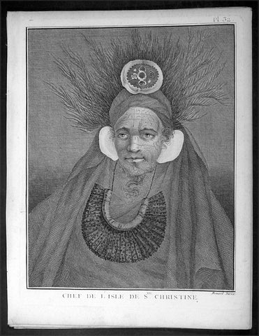
1778 Capt. Cook Antique Print Portrait Chief of Tahuata, Marquesas Isles in 1774
- Title : Chef De L Isle de Ste. Christine
- Ref : 16348
- Size: 10in x 8in (255mm x 205mm)
- Date : 1778
- Condition: (A+) Fine Condition
Description:
This fine original copper-plate engraved antique print, a portrait of Chief of Tahuata Island, Santa Cristina, in the Marquesas Islands, South Pacific, visited by Captain James Cook during his 2nd Voyage of Discovery in the South Seas in 1774, was engraved by Robert Benard - after William Hodges - and was published in the 1778 French edition of Capt. James Cooks 2nd Voyage of Discovery to the South Seas A voyage towards the South Pole, and round the World. Performed in His Majestys ships the Resolution and Adventure, in the years 1772, 1773, 1774, and 1775..... Paris : Hotel de Thou ......1778
Cook Diary (1774)
Apr. 7 Thu. Sights Hood’s Island (Fatu Huku), St. Pedro (Motare). La Dominica (Hiva Oa), St. Christina (Tahuata).
Apr 8 Fri. Sails along southern coast of Hiva Oa looking for anchorage. Anchors in Resolution (formerly Madre de Dios) Bay (Vaitahu Bay). Canoes arrive, gifts are exchanged. Natives killed after an iron stanchion is stolen.
Apr 9 Sat. Goes ashore, gifts exchanged, food obtained.
Apr 10 Sun. Goes ashore to south end of Bay and visits house of dead man. Gifts exchanged.
Apr 11 Mon. Goes ashore to south, again. Finds trade becoming expensive because of lavish gifts by his “gentlemen”.
Apr 12 Tue. Sails towards St. Dominica. No anchorage visible. Heads SW away from islands.
Apr 13 Wed. Sights last of the five main islands, Magdalena (Fatu Hiva).
General Definitions:
Paper thickness and quality: - Heavy and stable
Paper color : - off white
Age of map color: -
Colors used: -
General color appearance: -
Paper size: - 10in x 8in (255mm x 205mm)
Plate size: - 9 1/2in x 7 1/4in (240mm x 185mm)
Margins: - Min 1/2in (12mm)
Imperfections:
Margins: - Light soiling in margins
Plate area: - None
Verso: - None
Background:
Tahuata is the smallest of the inhabited Marquesas Islands, in French Polynesia, an overseas territory of France in the Pacific Ocean.
The first recorded sighting by Europeans was by the Spanish expedition of Álvaro de Mandaña on 22 July 1595. They charted the island as Santa Cristina. They landed at Vaitahu that they named Madre de Dios (Gods Mother in Spanish). According to the Spanish accounts Tahuata had fowls, fish, sugar cane, plantains, nuts and fruits. The existent town was built on two sides of a rectangular space, the houses being of timber and intertwined canes. A building which the Spaniards supposed to be a religious one stood outside the town, in a space enclosed by palisades, and containing some ill-carved images before which were offerings and provisions. The people had large and well constructed sailing canoes. Their tools were made of shells and fish bones. They used slings, stones, and lances as weapons.
Tahuata was visited by Captain James Cook in 1774 and Admiral Dupetit-Thouars in 1842, who signed the treaty annexing the Marquesas Islands to France.
The Marquesas Islands are a group of volcanic islands in French Polynesia, an overseas collective of France in the southern Pacific Ocean.
The first Europeans to reach the Marquesas may have been the crew of San Lesmes, a Spanish vessel which disappeared in a storm in June 1526; it was part of an expedition headed by García Jofre de Loaísa. The Spanish explorer Álvaro de Mendaña reached them seventy years later on 21 July 1595. He named them after his patron, García Hurtado de Mendoza, 5th Marquis of Cañete (Spanish: Marqués de Cañete), who served as Viceroy of Peru from 1590 to 1596. |Mendaña visited first Fatu Hiva and then Tahuata before continuing on to the Solomon Islands. His expedition charted the four southernmost Marquesas as Magdalena (Fatu Hiva), Dominica (Hiva ʻOa), San Pedro (Moho Tani), and Santa Cristina (Tahuata).
In the late 16th century European explorers estimated the population at more than 100,000. Europeans and Americans were impressed with how easy life appeared to be in the islands, which had a rich habitat and environment. In 1791 the American maritime fur trader Joseph Ingraham first visited the northern Marquesas while commanding the brig Hope. He named them the Washington Islands. In 1813 Commodore David Porter claimed Nuku Hiva for the United States, but the United States Congress never ratified that claim.
In 1842 France conducted a successful military operation on behalf of the native chief Iotete, who claimed he was king of the whole island of Tahuata. The government laid claim to the whole group and established a settlement on Nuku Hiva. That settlement was abandoned in 1857, but France re-established control over the group in 1870. It later incorporated the Marquesas into French Polynesia.
William Hodges RA 1744 – 1797 was an English painter. He was a member of James Cooks second voyage to the Pacific Ocean, and is best known for the sketches and paintings of locations he visited on that voyage, including Table Bay, Tahiti, Easter Island, and the Antarctic.
Between 1772 and 1775 Hodges accompanied James Cook to the Pacific as the expeditions artist. Many of his sketches and wash paintings were adapted as engravings in the original published edition of Cooks journals from the voyage.
Most of the large-scale landscape oil paintings from his Pacific travels for which Hodges is best known were finished after his return to London; he received a salary from the Admiralty for the purposes of completing them. These paintings depicted a stronger light and shadow than had been usual in European landscape tradition. Contemporary art critics complained that his use of light and colour contrasts gave his paintings a rough and unfinished appearance.
Hodges also produced many valuable portrait sketches of Pacific islanders and scenes from the voyage involving members of the expedition..
Robert Bénard 1734 – 1777 was an 18th-century French engraver.
Specialized in the technique of engraving, Robert Ménard is mainly famous for having supplied a significant amount of plates (at least 1,800) to the Encyclopédie by Diderot & d\'Alembert from 1751.
Later, publisher Charles-Joseph Panckoucke reused many of his productions to illustrate the works of his catalog.
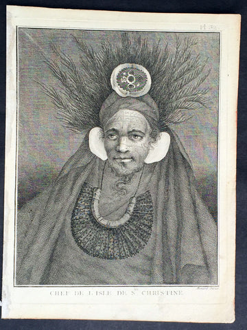
1778 Capt. Cook Antique Print Portrait Chief of Tahuata, Marquesas Isles in 1774
- Title : Chef De L Isle de Ste. Christine
- Ref : 31779
- Size: 10in x 8in (255mm x 205mm)
- Date : 1778
- Condition: (A+) Fine Condition
Description:
This fine original copper-plate engraved antique print, a portrait of Chief of Tahuata Island, Santa Cristina, in the Marquesas Islands, South Pacific, visited by Captain James Cook during his 2nd Voyage of Discovery in the South Seas in 1774, was engraved by Robert Benard - after William Hodges - and was published in the 1778 French edition of Capt. James Cooks 2nd Voyage of Discovery to the South Seas A voyage towards the South Pole, and round the World. Performed in His Majestys ships the Resolution and Adventure, in the years 1772, 1773, 1774, and 1775..... Paris : Hotel de Thou ......1778
Cook Diary (1774)
Apr. 7 Thu. Sights Hood’s Island (Fatu Huku), St. Pedro (Motare). La Dominica (Hiva Oa), St. Christina (Tahuata).
Apr 8 Fri. Sails along southern coast of Hiva Oa looking for anchorage. Anchors in Resolution (formerly Madre de Dios) Bay (Vaitahu Bay). Canoes arrive, gifts are exchanged. Natives killed after an iron stanchion is stolen.
Apr 9 Sat. Goes ashore, gifts exchanged, food obtained.
Apr 10 Sun. Goes ashore to south end of Bay and visits house of dead man. Gifts exchanged.
Apr 11 Mon. Goes ashore to south, again. Finds trade becoming expensive because of lavish gifts by his “gentlemen”.
Apr 12 Tue. Sails towards St. Dominica. No anchorage visible. Heads SW away from islands.
Apr 13 Wed. Sights last of the five main islands, Magdalena (Fatu Hiva).
General Definitions:
Paper thickness and quality: - Heavy and stable
Paper color : - off white
Age of map color: -
Colors used: -
General color appearance: -
Paper size: - 10in x 8in (255mm x 205mm)
Plate size: - 9 1/2in x 7 1/4in (240mm x 185mm)
Margins: - Min 1/2in (12mm)
Imperfections:
Margins: - Light soiling in margins
Plate area: - None
Verso: - None
Background:
Tahuata is the smallest of the inhabited Marquesas Islands, in French Polynesia, an overseas territory of France in the Pacific Ocean.
The first recorded sighting by Europeans was by the Spanish expedition of Álvaro de Mandaña on 22 July 1595. They charted the island as Santa Cristina. They landed at Vaitahu that they named Madre de Dios (Gods Mother in Spanish). According to the Spanish accounts Tahuata had fowls, fish, sugar cane, plantains, nuts and fruits. The existent town was built on two sides of a rectangular space, the houses being of timber and intertwined canes. A building which the Spaniards supposed to be a religious one stood outside the town, in a space enclosed by palisades, and containing some ill-carved images before which were offerings and provisions. The people had large and well constructed sailing canoes. Their tools were made of shells and fish bones. They used slings, stones, and lances as weapons.
Tahuata was visited by Captain James Cook in 1774 and Admiral Dupetit-Thouars in 1842, who signed the treaty annexing the Marquesas Islands to France.
The Marquesas Islands are a group of volcanic islands in French Polynesia, an overseas collective of France in the southern Pacific Ocean.
The first Europeans to reach the Marquesas may have been the crew of San Lesmes, a Spanish vessel which disappeared in a storm in June 1526; it was part of an expedition headed by García Jofre de Loaísa. The Spanish explorer Álvaro de Mendaña reached them seventy years later on 21 July 1595. He named them after his patron, García Hurtado de Mendoza, 5th Marquis of Cañete (Spanish: Marqués de Cañete), who served as Viceroy of Peru from 1590 to 1596. |Mendaña visited first Fatu Hiva and then Tahuata before continuing on to the Solomon Islands. His expedition charted the four southernmost Marquesas as Magdalena (Fatu Hiva), Dominica (Hiva ʻOa), San Pedro (Moho Tani), and Santa Cristina (Tahuata).
In the late 16th century European explorers estimated the population at more than 100,000. Europeans and Americans were impressed with how easy life appeared to be in the islands, which had a rich habitat and environment. In 1791 the American maritime fur trader Joseph Ingraham first visited the northern Marquesas while commanding the brig Hope. He named them the Washington Islands. In 1813 Commodore David Porter claimed Nuku Hiva for the United States, but the United States Congress never ratified that claim.
In 1842 France conducted a successful military operation on behalf of the native chief Iotete, who claimed he was king of the whole island of Tahuata. The government laid claim to the whole group and established a settlement on Nuku Hiva. That settlement was abandoned in 1857, but France re-established control over the group in 1870. It later incorporated the Marquesas into French Polynesia.
William Hodges RA 1744 – 1797 was an English painter. He was a member of James Cooks second voyage to the Pacific Ocean, and is best known for the sketches and paintings of locations he visited on that voyage, including Table Bay, Tahiti, Easter Island, and the Antarctic.
Between 1772 and 1775 Hodges accompanied James Cook to the Pacific as the expeditions artist. Many of his sketches and wash paintings were adapted as engravings in the original published edition of Cooks journals from the voyage.
Most of the large-scale landscape oil paintings from his Pacific travels for which Hodges is best known were finished after his return to London; he received a salary from the Admiralty for the purposes of completing them. These paintings depicted a stronger light and shadow than had been usual in European landscape tradition. Contemporary art critics complained that his use of light and colour contrasts gave his paintings a rough and unfinished appearance.
Hodges also produced many valuable portrait sketches of Pacific islanders and scenes from the voyage involving members of the expedition..
Robert Bénard 1734 – 1777 was an 18th-century French engraver.
Specialized in the technique of engraving, Robert Ménard is mainly famous for having supplied a significant amount of plates (at least 1,800) to the Encyclopédie by Diderot & d\'Alembert from 1751.
Later, publisher Charles-Joseph Panckoucke reused many of his productions to illustrate the works of his catalog.
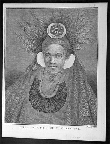
1778 Capt. Cook Antique Print Portrait Chief of Tahuata, Marquesas Isles in 1774
- Title : Chef De L Isle de Ste. Christine
- Ref : 21328
- Size: 10in x 8in (255mm x 205mm)
- Date : 1778
- Condition: (A+) Fine Condition
Description:
This fine original copper-plate engraved antique print, a portrait of Chief of Tahuata Island, Santa Cristina, in the Marquesas Islands, South Pacific, visited by Captain James Cook during his 2nd Voyage of Discovery in the South Seas in 1774, was engraved by Robert Benard - after William Hodges - and was published in the 1778 French edition of Capt. James Cooks 2nd Voyage of Discovery to the South Seas A voyage towards the South Pole, and round the World. Performed in His Majestys ships the Resolution and Adventure, in the years 1772, 1773, 1774, and 1775..... Paris : Hotel de Thou ......1778
Cook Diary (1774)
Apr. 7 Thu. Sights Hood’s Island (Fatu Huku), St. Pedro (Motare). La Dominica (Hiva Oa), St. Christina (Tahuata).
Apr 8 Fri. Sails along southern coast of Hiva Oa looking for anchorage. Anchors in Resolution (formerly Madre de Dios) Bay (Vaitahu Bay). Canoes arrive, gifts are exchanged. Natives killed after an iron stanchion is stolen.
Apr 9 Sat. Goes ashore, gifts exchanged, food obtained.
Apr 10 Sun. Goes ashore to south end of Bay and visits house of dead man. Gifts exchanged.
Apr 11 Mon. Goes ashore to south, again. Finds trade becoming expensive because of lavish gifts by his “gentlemen”.
Apr 12 Tue. Sails towards St. Dominica. No anchorage visible. Heads SW away from islands.
Apr 13 Wed. Sights last of the five main islands, Magdalena (Fatu Hiva).
General Definitions:
Paper thickness and quality: - Heavy and stable
Paper color : - off white
Age of map color: -
Colors used: -
General color appearance: -
Paper size: - 10in x 8in (255mm x 205mm)
Plate size: - 9 1/2in x 7 1/4in (240mm x 185mm)
Margins: - Min 1/2in (12mm)
Imperfections:
Margins: - Light soiling in margins
Plate area: - None
Verso: - None
Background:
Tahuata is the smallest of the inhabited Marquesas Islands, in French Polynesia, an overseas territory of France in the Pacific Ocean.
The first recorded sighting by Europeans was by the Spanish expedition of Álvaro de Mandaña on 22 July 1595. They charted the island as Santa Cristina. They landed at Vaitahu that they named Madre de Dios (Gods Mother in Spanish). According to the Spanish accounts Tahuata had fowls, fish, sugar cane, plantains, nuts and fruits. The existent town was built on two sides of a rectangular space, the houses being of timber and intertwined canes. A building which the Spaniards supposed to be a religious one stood outside the town, in a space enclosed by palisades, and containing some ill-carved images before which were offerings and provisions. The people had large and well constructed sailing canoes. Their tools were made of shells and fish bones. They used slings, stones, and lances as weapons.
Tahuata was visited by Captain James Cook in 1774 and Admiral Dupetit-Thouars in 1842, who signed the treaty annexing the Marquesas Islands to France.
The Marquesas Islands are a group of volcanic islands in French Polynesia, an overseas collective of France in the southern Pacific Ocean.
The first Europeans to reach the Marquesas may have been the crew of San Lesmes, a Spanish vessel which disappeared in a storm in June 1526; it was part of an expedition headed by García Jofre de Loaísa. The Spanish explorer Álvaro de Mendaña reached them seventy years later on 21 July 1595. He named them after his patron, García Hurtado de Mendoza, 5th Marquis of Cañete (Spanish: Marqués de Cañete), who served as Viceroy of Peru from 1590 to 1596. |Mendaña visited first Fatu Hiva and then Tahuata before continuing on to the Solomon Islands. His expedition charted the four southernmost Marquesas as Magdalena (Fatu Hiva), Dominica (Hiva ʻOa), San Pedro (Moho Tani), and Santa Cristina (Tahuata).
In the late 16th century European explorers estimated the population at more than 100,000. Europeans and Americans were impressed with how easy life appeared to be in the islands, which had a rich habitat and environment. In 1791 the American maritime fur trader Joseph Ingraham first visited the northern Marquesas while commanding the brig Hope. He named them the Washington Islands. In 1813 Commodore David Porter claimed Nuku Hiva for the United States, but the United States Congress never ratified that claim.
In 1842 France conducted a successful military operation on behalf of the native chief Iotete, who claimed he was king of the whole island of Tahuata. The government laid claim to the whole group and established a settlement on Nuku Hiva. That settlement was abandoned in 1857, but France re-established control over the group in 1870. It later incorporated the Marquesas into French Polynesia.
William Hodges RA 1744 – 1797 was an English painter. He was a member of James Cooks second voyage to the Pacific Ocean, and is best known for the sketches and paintings of locations he visited on that voyage, including Table Bay, Tahiti, Easter Island, and the Antarctic.
Between 1772 and 1775 Hodges accompanied James Cook to the Pacific as the expeditions artist. Many of his sketches and wash paintings were adapted as engravings in the original published edition of Cooks journals from the voyage.
Most of the large-scale landscape oil paintings from his Pacific travels for which Hodges is best known were finished after his return to London; he received a salary from the Admiralty for the purposes of completing them. These paintings depicted a stronger light and shadow than had been usual in European landscape tradition. Contemporary art critics complained that his use of light and colour contrasts gave his paintings a rough and unfinished appearance.
Hodges also produced many valuable portrait sketches of Pacific islanders and scenes from the voyage involving members of the expedition..
Robert Bénard 1734 – 1777 was an 18th-century French engraver.
Specialized in the technique of engraving, Robert Ménard is mainly famous for having supplied a significant amount of plates (at least 1,800) to the Encyclopédie by Diderot & d\'Alembert from 1751.
Later, publisher Charles-Joseph Panckoucke reused many of his productions to illustrate the works of his catalog.
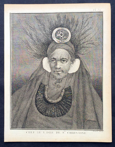
1778 Capt. Cook Antique Print Portrait Chief of Tahuata, Marquesas Isles in 1774
- Title : Chef De L Isle de Ste. Christine
- Ref : 31807
- Size: 10in x 8in (255mm x 205mm)
- Date : 1778
- Condition: (A+) Fine Condition
Description:
This fine original copper-plate engraved antique print, a portrait of Chief of Tahuata Island, Santa Cristina, in the Marquesas Islands, South Pacific, visited by Captain James Cook during his 2nd Voyage of Discovery in the South Seas in 1774, was engraved by Robert Benard - after William Hodges - and was published in the 1778 French edition of Capt. James Cooks 2nd Voyage of Discovery to the South Seas A voyage towards the South Pole, and round the World. Performed in His Majestys ships the Resolution and Adventure, in the years 1772, 1773, 1774, and 1775..... Paris : Hotel de Thou ......1778
Cook Diary (1774)
Apr. 7 Thu. Sights Hood’s Island (Fatu Huku), St. Pedro (Motare). La Dominica (Hiva Oa), St. Christina (Tahuata).
Apr 8 Fri. Sails along southern coast of Hiva Oa looking for anchorage. Anchors in Resolution (formerly Madre de Dios) Bay (Vaitahu Bay). Canoes arrive, gifts are exchanged. Natives killed after an iron stanchion is stolen.
Apr 9 Sat. Goes ashore, gifts exchanged, food obtained.
Apr 10 Sun. Goes ashore to south end of Bay and visits house of dead man. Gifts exchanged.
Apr 11 Mon. Goes ashore to south, again. Finds trade becoming expensive because of lavish gifts by his “gentlemen”.
Apr 12 Tue. Sails towards St. Dominica. No anchorage visible. Heads SW away from islands.
Apr 13 Wed. Sights last of the five main islands, Magdalena (Fatu Hiva).
General Definitions:
Paper thickness and quality: - Heavy and stable
Paper color : - off white
Age of map color: -
Colors used: -
General color appearance: -
Paper size: - 10in x 8in (255mm x 205mm)
Plate size: - 9 1/2in x 7 1/4in (240mm x 185mm)
Margins: - Min 1/2in (12mm)
Imperfections:
Margins: - Light soiling in margins
Plate area: - None
Verso: - None
Background:
Tahuata is the smallest of the inhabited Marquesas Islands, in French Polynesia, an overseas territory of France in the Pacific Ocean.
The first recorded sighting by Europeans was by the Spanish expedition of Álvaro de Mandaña on 22 July 1595. They charted the island as Santa Cristina. They landed at Vaitahu that they named Madre de Dios (Gods Mother in Spanish). According to the Spanish accounts Tahuata had fowls, fish, sugar cane, plantains, nuts and fruits. The existent town was built on two sides of a rectangular space, the houses being of timber and intertwined canes. A building which the Spaniards supposed to be a religious one stood outside the town, in a space enclosed by palisades, and containing some ill-carved images before which were offerings and provisions. The people had large and well constructed sailing canoes. Their tools were made of shells and fish bones. They used slings, stones, and lances as weapons.
Tahuata was visited by Captain James Cook in 1774 and Admiral Dupetit-Thouars in 1842, who signed the treaty annexing the Marquesas Islands to France.
The Marquesas Islands are a group of volcanic islands in French Polynesia, an overseas collective of France in the southern Pacific Ocean.
The first Europeans to reach the Marquesas may have been the crew of San Lesmes, a Spanish vessel which disappeared in a storm in June 1526; it was part of an expedition headed by García Jofre de Loaísa. The Spanish explorer Álvaro de Mendaña reached them seventy years later on 21 July 1595. He named them after his patron, García Hurtado de Mendoza, 5th Marquis of Cañete (Spanish: Marqués de Cañete), who served as Viceroy of Peru from 1590 to 1596. |Mendaña visited first Fatu Hiva and then Tahuata before continuing on to the Solomon Islands. His expedition charted the four southernmost Marquesas as Magdalena (Fatu Hiva), Dominica (Hiva ʻOa), San Pedro (Moho Tani), and Santa Cristina (Tahuata).
In the late 16th century European explorers estimated the population at more than 100,000. Europeans and Americans were impressed with how easy life appeared to be in the islands, which had a rich habitat and environment. In 1791 the American maritime fur trader Joseph Ingraham first visited the northern Marquesas while commanding the brig Hope. He named them the Washington Islands. In 1813 Commodore David Porter claimed Nuku Hiva for the United States, but the United States Congress never ratified that claim.
In 1842 France conducted a successful military operation on behalf of the native chief Iotete, who claimed he was king of the whole island of Tahuata. The government laid claim to the whole group and established a settlement on Nuku Hiva. That settlement was abandoned in 1857, but France re-established control over the group in 1870. It later incorporated the Marquesas into French Polynesia.
William Hodges RA 1744 – 1797 was an English painter. He was a member of James Cooks second voyage to the Pacific Ocean, and is best known for the sketches and paintings of locations he visited on that voyage, including Table Bay, Tahiti, Easter Island, and the Antarctic.
Between 1772 and 1775 Hodges accompanied James Cook to the Pacific as the expeditions artist. Many of his sketches and wash paintings were adapted as engravings in the original published edition of Cooks journals from the voyage.
Most of the large-scale landscape oil paintings from his Pacific travels for which Hodges is best known were finished after his return to London; he received a salary from the Admiralty for the purposes of completing them. These paintings depicted a stronger light and shadow than had been usual in European landscape tradition. Contemporary art critics complained that his use of light and colour contrasts gave his paintings a rough and unfinished appearance.
Hodges also produced many valuable portrait sketches of Pacific islanders and scenes from the voyage involving members of the expedition..
Robert Bénard 1734 – 1777 was an 18th-century French engraver.
Specialized in the technique of engraving, Robert Ménard is mainly famous for having supplied a significant amount of plates (at least 1,800) to the Encyclopédie by Diderot & d\'Alembert from 1751.
Later, publisher Charles-Joseph Panckoucke reused many of his productions to illustrate the works of his catalog.
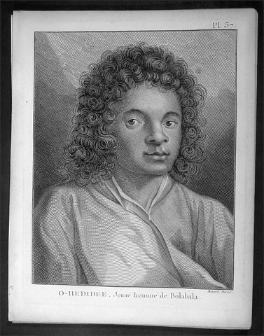
1778 Capt. Cook Antique Print Portrait of Oedidee, Bora Bora met by Cook in 1773
- Title : O-Hedidee, Jeune homme de Bolabala
- Ref : 16355
- Size: 10in x 8in (255mm x 205mm)
- Date : 1778
- Condition: (A+) Fine Condition
Description:
This fine original copper-plate engraved antique print, a portrait of O-Hedidee or Oedidee of the island of Bora Bora in the Society Islands, met by Captain James Cook during his 2nd Voyage of Discovery in the South Seas in 1773, was engraved by Robert Benard - after William Hodges - and was published in the 1778 French edition of Capt. James Cooks 2nd Voyage of Discovery to the South Seas A voyage towards the South Pole, and round the World. Performed in His Majestys ships the Resolution and Adventure, in the years 1772, 1773, 1774, and 1775..... Paris : Hotel de Thou ......1778
O-Hedidee or Oedidee, was a native of Bora Bora, Society Islands, French Polynesia, was about 17 or 18 years of age when he was taken on board the Resolution at Raiatea Island on 17 September 1773. He is described in Hawkesworths account as a young man with curly hair and flattish nose, wearing a gown. Cook wrote: he may be of use to us if we should fall in with and touch at any isles in our rout to the west which was my only motive for taking him on board. Cook Journals II.
O-Hedidee traveled with Cook from Raiatea to New Zealand, Easter Island, and Tahiti, returning to Raiatea on 4 June 1774, having been with the Resolutions company for seven months.
General Definitions:
Paper thickness and quality: - Heavy and stable
Paper color : - off white
Age of map color: -
Colors used: -
General color appearance: -
Paper size: - 10in x 8in (255mm x 205mm)
Plate size: - 9 1/2in x 7 1/4in (240mm x 185mm)
Margins: - Min 1/2in (12mm)
Imperfections:
Margins: - Light soiling in margins
Plate area: - None
Verso: - None
Background:
Bora Bora is a 30.55 km2 island group in the Leeward group in the western part of the Society Islands of French Polynesia, an overseas collective of France in the Pacific Ocean. The main island, located about 230 kilometres northwest of Papeete, Tahiti is surrounded by a lagoon and a barrier reef. In the center of the island are the remnants of an extinct volcano rising to two peaks, Mount Pahia and Mount Otemanu, the highest point at 727 metres
The island was inhabited by Polynesian settlers around the 4th century C.E. The first European sighting was made by Jakob Roggeveen in 1722.
James Cook sighted the island on 29 July 1769, using a Tahitian navigator, Tupaia. The London Missionary Society arrived in 1820 and founded a Protestant church in 1890. Bora Bora was an independent kingdom until 1888 when its last queen Teriimaevarua III was forced to abdicate by the French who annexed the island as a colony.
William Hodges RA 1744 – 1797 was an English painter. He was a member of James Cooks second voyage to the Pacific Ocean, and is best known for the sketches and paintings of locations he visited on that voyage, including Table Bay, Tahiti, Easter Island, and the Antarctic.
Between 1772 and 1775 Hodges accompanied James Cook to the Pacific as the expeditions artist. Many of his sketches and wash paintings were adapted as engravings in the original published edition of Cooks journals from the voyage.
Most of the large-scale landscape oil paintings from his Pacific travels for which Hodges is best known were finished after his return to London; he received a salary from the Admiralty for the purposes of completing them. These paintings depicted a stronger light and shadow than had been usual in European landscape tradition. Contemporary art critics complained that his use of light and colour contrasts gave his paintings a rough and unfinished appearance.
Hodges also produced many valuable portrait sketches of Pacific islanders and scenes from the voyage involving members of the expedition..
Robert Bénard 1734 – 1777 was an 18th-century French engraver.
Specialized in the technique of engraving, Robert Ménard is mainly famous for having supplied a significant amount of plates (at least 1,800) to the Encyclopédie by Diderot & d\'Alembert from 1751.
Later, publisher Charles-Joseph Panckoucke reused many of his productions to illustrate the works of his catalog.
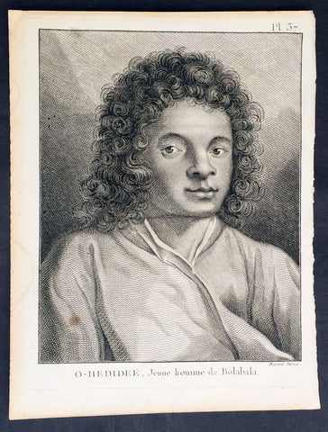
1778 Capt. Cook Antique Print Portrait of Oedidee, Bora Bora met by Cook in 1773
- Title : O-Hedidee, Jeune homme de Bolabala
- Ref : 31774
- Size: 10in x 8in (255mm x 205mm)
- Date : 1778
- Condition: (A+) Fine Condition
Description:
This fine original copper-plate engraved antique print, a portrait of O-Hedidee or Oedidee of the island of Bora Bora in the Society Islands, met by Captain James Cook during his 2nd Voyage of Discovery in the South Seas in 1773, was engraved by Robert Benard - after William Hodges - and was published in the 1778 French edition of Capt. James Cooks 2nd Voyage of Discovery to the South Seas A voyage towards the South Pole, and round the World. Performed in His Majestys ships the Resolution and Adventure, in the years 1772, 1773, 1774, and 1775..... Paris : Hotel de Thou ......1778
O-Hedidee or Oedidee, was a native of Bora Bora, Society Islands, French Polynesia, was about 17 or 18 years of age when he was taken on board the Resolution at Raiatea Island on 17 September 1773. He is described in Hawkesworths account as a young man with curly hair and flattish nose, wearing a gown. Cook wrote: he may be of use to us if we should fall in with and touch at any isles in our rout to the west which was my only motive for taking him on board. Cook Journals II.
O-Hedidee traveled with Cook from Raiatea to New Zealand, Easter Island, and Tahiti, returning to Raiatea on 4 June 1774, having been with the Resolutions company for seven months.
General Definitions:
Paper thickness and quality: - Heavy and stable
Paper color : - off white
Age of map color: -
Colors used: -
General color appearance: -
Paper size: - 10in x 8in (255mm x 205mm)
Plate size: - 9 1/2in x 7 1/4in (240mm x 185mm)
Margins: - Min 1/2in (12mm)
Imperfections:
Margins: - Light soiling in margins
Plate area: - None
Verso: - None
Background:
Bora Bora is a 30.55 km2 island group in the Leeward group in the western part of the Society Islands of French Polynesia, an overseas collective of France in the Pacific Ocean. The main island, located about 230 kilometres northwest of Papeete, Tahiti is surrounded by a lagoon and a barrier reef. In the center of the island are the remnants of an extinct volcano rising to two peaks, Mount Pahia and Mount Otemanu, the highest point at 727 metres
The island was inhabited by Polynesian settlers around the 4th century C.E. The first European sighting was made by Jakob Roggeveen in 1722.
James Cook sighted the island on 29 July 1769, using a Tahitian navigator, Tupaia. The London Missionary Society arrived in 1820 and founded a Protestant church in 1890. Bora Bora was an independent kingdom until 1888 when its last queen Teriimaevarua III was forced to abdicate by the French who annexed the island as a colony.
William Hodges RA 1744 – 1797 was an English painter. He was a member of James Cooks second voyage to the Pacific Ocean, and is best known for the sketches and paintings of locations he visited on that voyage, including Table Bay, Tahiti, Easter Island, and the Antarctic.
Between 1772 and 1775 Hodges accompanied James Cook to the Pacific as the expeditions artist. Many of his sketches and wash paintings were adapted as engravings in the original published edition of Cooks journals from the voyage.
Most of the large-scale landscape oil paintings from his Pacific travels for which Hodges is best known were finished after his return to London; he received a salary from the Admiralty for the purposes of completing them. These paintings depicted a stronger light and shadow than had been usual in European landscape tradition. Contemporary art critics complained that his use of light and colour contrasts gave his paintings a rough and unfinished appearance.
Hodges also produced many valuable portrait sketches of Pacific islanders and scenes from the voyage involving members of the expedition..
Robert Bénard 1734 – 1777 was an 18th-century French engraver.
Specialized in the technique of engraving, Robert Ménard is mainly famous for having supplied a significant amount of plates (at least 1,800) to the Encyclopédie by Diderot & d\'Alembert from 1751.
Later, publisher Charles-Joseph Panckoucke reused many of his productions to illustrate the works of his catalog.
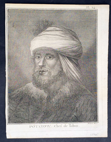
1778 Capt. Cook Antique Print Portrait of Chief Potatau of Punaauia, Tahiti 1773
- Title : Potatow, Chef de Tahiti
- Ref : 21415
- Size: 10in x 8in (255mm x 205mm)
- Date : 1778
- Condition: (A+) Fine Condition
Description:
This fine original copper-plate engraved antique print, a portrait of Chief Potatau of Punaauia in Tahiti, French Polynesia, met by Captain James Cook during his 2nd Voyage of Discovery in the South Seas in 1773, was engraved by Robert Benard - after William Hodges - and was published in the 1778 French edition of Capt. James Cooks 2nd Voyage of Discovery to the South Seas A voyage towards the South Pole, and round the World. Performed in His Majestys ships the Resolution and Adventure, in the years 1772, 1773, 1774, and 1775..... Paris : Hotel de Thou ......1778
Cooks Biography............George Vancouver (midshipman, of later fame) meanwhile, stayed behind to contemplate the role of the red feather in Tahitian society. It happened that Chief Potatau consulted with his wife on how they might obtain some of Cook\'s Oora and according to the plan that somehow reached Georges ears, she would go to Cook in his cabin and offer her services in return for said feathers. But the Captain was unswayed. It was just as well that Georges father was absent on this particular occasion, for he would only have been upset. As it was, his sleep was often disturbed by the sailors running all over the ship with their sexual partners at any hour of the night.
Such was Tahitian zeal for red feathers, Clerke remarked, that they gladly engaged in rather unhallow\'d rites for the sacred jewels in order to offer Propitiation to their Jolly Gods. Such was the maritime zeal for the Tahitian religion that the sailors fairly plundered the ship of its treasures; feathers were ripped from lovely Tongan garments and from delicate fretwork on coconuts; sailors even dyed plain feathers red. Thus valuable artifacts of the South Seas were undone. Nevertheless, among the treasures that came aboard were Potatau\'s monstrous helmets of war of five feet high and several handsome mourning dresses to become in due course part of the collections of ethnology in the Ashmolean Museum and the Bishop Museum. Besides the red feathers, the abundance of pork also attracted the girls; they consumed incredible quantities, reported George, because, as members of a poor class of Tahitians, they were denied pork in their own households. Such were the quantities they consumed, added George with a certain delicacy, that of a sudden they suffered the inconvenience of restlessness, and when they were refused the attention of their lovers, the very decks began to resemble the paths in the islands.........
General Definitions:
Paper thickness and quality: - Heavy and stable
Paper color : - off white
Age of map color: -
Colors used: -
General color appearance: -
Paper size: - 10in x 8in (255mm x 205mm)
Plate size: - 9 1/2in x 7 1/4in (240mm x 185mm)
Margins: - Min 1/2in (12mm)
Imperfections:
Margins: - Light soiling in margins
Plate area: - None
Verso: - None
Background:
Tahiti previously also known as Otaheite is the largest island in the Windward group of French Polynesia. The island is located in the archipelago of the Society Islands in the central Southern Pacific Ocean.
The first European to have visited Tahiti according to existing records was lieutenant Samuel Wallis, who was circumnavigating the globe in HMS Dolphin, sighting the island on 18 June 1767, and eventually harboring in Matavai Bay. This bay was situated on the territory of the chiefdom of Pare-Arue, governed by Tu (Tu-nui-e-a a-i-te-Atua) and his regent Tutaha, and the chiefdom of Ha apape, governed by Amo and his wife Oberea (Purea). Wallis named the island King Georges Island. The first contacts were difficult, since on the 24 and 26 June 1767, Tahitian warriors in canoes showed aggression towards the British, hurling stones from their slings. In retaliation, the British sailors opened fire on the warriors in the canoes and on the hills. In reaction to this powerful counter-attack, the Tahitians laid down peace offerings for the British. Following this episode, Samuel Wallis was able to establish cordial relations with the female chieftain “Oberea “ (Purea) and remained on the island until 27 July 1767.
In July 1768, Captain James Cook was commissioned by the Royal Society and on orders from the Lords Commissioners of the Admiralty to observe the transit of Venus across the sun, a phenomenon that would be visible from Tahiti on 3 June 1769. He arrived in Tahitis Matavai Bay, commanding the HMS Endeavour on 12 April 1769. On 14 April, Cook met with Tutaha and Tepau. On 15 April, Cook picked the site for a fortified camp at Point Venus along with Banks, Parkinson, Daniel Solander, to protect Charles Greens observatory. The length of stay enabled them to undertake for the first time real ethnographic and scientific observations of the island. Assisted by the botanist Joseph Banks, and by the artist Sydney Parkinson, Cook gathered valuable information on the fauna and flora, as well as the native society, language and customs, including the proper name of the island, Otaheite. On 28 April, Cook met Purea and Tupaia, and Tupaia befriended Banks following the transit. On 21 June, Amo visited Cook, and then on 25 June, Pohuetea visited, signifying another chief seeking to ally himself with the British.
Cook and Banks circumnavigated the island from 26 June to 1 July. On the exploration, they met Ahio, chief of Ha apaiano o or Papenoo, Rita, chief of Hitia a, Pahairro, chief of Pueu, Vehiatua, chief of Tautra, Matahiapo, chief of Teahupo o, Tutea, chief of Vaira o, and Moe, chief of Afa Ahiti. In Papara, guided by Tupaia, they investigated the ruins of Mahaiatea marae, an impressive structure containing a stone pyramid or ahu, measuring 44 feet high, 267 feet long and 87 feet wide. Cook and the Endeavour departed Tahiti on 13 July 1769, taking Raiatean navigator Tupaia along for his geographic knowledge of the islands.
Cook returned to Tahiti between 15 August and 1 September 1773, greeted by the chiefs Tai and Puhi, besides the youg ari i Vehiatua II and his stepfather Ti itorea. Cook anchored in Vaitepiha Bay before returning to Point Venus where he met Tu, the paramount chief. Cook picked up two passengers from Tahiti during this trip, Porea and Mai, with Hitihiti later replacing Porea when Cook stopped at Raiatea. Cook took Hitihiti to Tahiti on 22 April, during his return leg. Then, Cook departed Tahiti on 14 May 1774.
During his final visit, Cook returned Mai to Tahiti on 12 Aug. 1777, after Mais long visit in England. Cook also brought two Maori from Queen Charlotte Sound, Te Weherua and Koa. Cook first harbored in Vaitepiha Bay, where he visited Vehiatua II s funeral bier and the prefabricated Spanish mission house. Cook also met Vehiatua III, and inscribed on the back of the Spanish cross, Georgius tertius Rex Annis 1767, 69, 73, 74 & 77, as a counterpoint to Christus Vincit Carolus III imperat 1774 on the front. On 23 Aug., Cook sailed for Matavai Bay, where he met Tu, his father Teu, his mother Tetupaia, his brothers Ari ipaea and Vaetua, and his sisters Ari ipaea-vahine, Tetua-te-ahamai, and Auo. Cook also observed a human sacrifice, taata tapu, at the Utu-ai-mahurau marae, and 49 skulls from previous victims.
On 29 Sept. 1777, Cook sailed for Papetoai Bay on Moorea. Cook met Mahine in an act of friendship on 3 Oct., though he was an enemy of Tu. When a goat kid was stolen on 6 Oct., Cook in a rampage, ordered the burning of houses and canoes until it was returned. Cook sailed for Huahine on 11 Oct., Raiatea on 2 Nov., and Borabora on 7 Dec.
On 26 October 1788, HMS Bounty, under the command of Captain William Bligh, landed in Tahiti with the mission of carrying Tahitian breadfruit trees (Tahitian: uru) to the Caribbean. Sir Joseph Banks, the botanist from James Cooks first expedition, had concluded that this plant would be ideal to feed the African slaves working in the Caribbean plantations at very little cost. The crew remained in Tahiti for about five months, the time needed to transplant the seedlings of the trees. Three weeks after leaving Tahiti, on 28 April 1789, the crew mutinied on the initiative of Fletcher Christian. The mutineers seized the ship and set the captain and most of those members of the crew who remained loyal to him adrift in a ships boat. A group of mutineers then went back to settle in Tahiti.
Although various explorers had refused to get involved in tribal conflicts, the mutineers from the Bounty offered their services as mercenaries and furnished arms to the family which became the Pōmare Dynasty. The chief Tū knew how to use their presence in the harbours favoured by sailors to his advantage. As a result of his alliance with the mutineers, he succeeded in considerably increasing his supremacy over the island of Tahiti.
William Hodges RA 1744 – 1797 was an English painter. He was a member of James Cooks second voyage to the Pacific Ocean, and is best known for the sketches and paintings of locations he visited on that voyage, including Table Bay, Tahiti, Easter Island, and the Antarctic.
Between 1772 and 1775 Hodges accompanied James Cook to the Pacific as the expeditions artist. Many of his sketches and wash paintings were adapted as engravings in the original published edition of Cooks journals from the voyage.
Most of the large-scale landscape oil paintings from his Pacific travels for which Hodges is best known were finished after his return to London; he received a salary from the Admiralty for the purposes of completing them. These paintings depicted a stronger light and shadow than had been usual in European landscape tradition. Contemporary art critics complained that his use of light and colour contrasts gave his paintings a rough and unfinished appearance.
Hodges also produced many valuable portrait sketches of Pacific islanders and scenes from the voyage involving members of the expedition..
Robert Bénard 1734 – 1777 was an 18th-century French engraver.
Specialized in the technique of engraving, Robert Ménard is mainly famous for having supplied a significant amount of plates (at least 1,800) to the Encyclopédie by Diderot & d\'Alembert from 1751.
Later, publisher Charles-Joseph Panckoucke reused many of his productions to illustrate the works of his catalog.
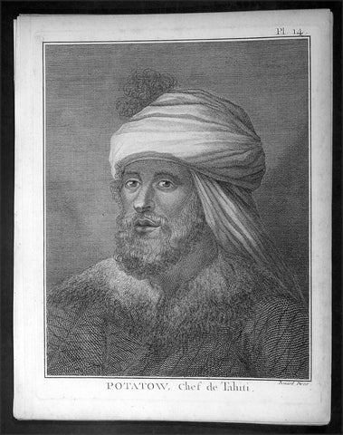
1778 Capt. Cook Antique Print Portrait of Chief Potatau of Punaauia, Tahiti 1773
- Title : Potatow, Chef de Tahiti
- Ref : 16353
- Size: 10in x 8in (255mm x 205mm)
- Date : 1778
- Condition: (A+) Fine Condition
Description:
This fine original copper-plate engraved antique print, a portrait of Chief Potatau of Punaauia in Tahiti, French Polynesia, met by Captain James Cook during his 2nd Voyage of Discovery in the South Seas in 1773, was engraved by Robert Benard - after William Hodges - and was published in the 1778 French edition of Capt. James Cooks 2nd Voyage of Discovery to the South Seas A voyage towards the South Pole, and round the World. Performed in His Majestys ships the Resolution and Adventure, in the years 1772, 1773, 1774, and 1775..... Paris : Hotel de Thou ......1778
Cooks Biography............George Vancouver (midshipman, of later fame) meanwhile, stayed behind to contemplate the role of the red feather in Tahitian society. It happened that Chief Potatau consulted with his wife on how they might obtain some of Cook\'s Oora and according to the plan that somehow reached Georges ears, she would go to Cook in his cabin and offer her services in return for said feathers. But the Captain was unswayed. It was just as well that Georges father was absent on this particular occasion, for he would only have been upset. As it was, his sleep was often disturbed by the sailors running all over the ship with their sexual partners at any hour of the night.
Such was Tahitian zeal for red feathers, Clerke remarked, that they gladly engaged in rather unhallow\'d rites for the sacred jewels in order to offer Propitiation to their Jolly Gods. Such was the maritime zeal for the Tahitian religion that the sailors fairly plundered the ship of its treasures; feathers were ripped from lovely Tongan garments and from delicate fretwork on coconuts; sailors even dyed plain feathers red. Thus valuable artifacts of the South Seas were undone. Nevertheless, among the treasures that came aboard were Potatau\'s monstrous helmets of war of five feet high and several handsome mourning dresses to become in due course part of the collections of ethnology in the Ashmolean Museum and the Bishop Museum. Besides the red feathers, the abundance of pork also attracted the girls; they consumed incredible quantities, reported George, because, as members of a poor class of Tahitians, they were denied pork in their own households. Such were the quantities they consumed, added George with a certain delicacy, that of a sudden they suffered the inconvenience of restlessness, and when they were refused the attention of their lovers, the very decks began to resemble the paths in the islands.........
General Definitions:
Paper thickness and quality: - Heavy and stable
Paper color : - off white
Age of map color: -
Colors used: -
General color appearance: -
Paper size: - 10in x 8in (255mm x 205mm)
Plate size: - 9 1/2in x 7 1/4in (240mm x 185mm)
Margins: - Min 1/2in (12mm)
Imperfections:
Margins: - Light soiling in margins
Plate area: - None
Verso: - None
Background:
Tahiti previously also known as Otaheite is the largest island in the Windward group of French Polynesia. The island is located in the archipelago of the Society Islands in the central Southern Pacific Ocean.
The first European to have visited Tahiti according to existing records was lieutenant Samuel Wallis, who was circumnavigating the globe in HMS Dolphin, sighting the island on 18 June 1767, and eventually harboring in Matavai Bay. This bay was situated on the territory of the chiefdom of Pare-Arue, governed by Tu (Tu-nui-e-a a-i-te-Atua) and his regent Tutaha, and the chiefdom of Ha apape, governed by Amo and his wife Oberea (Purea). Wallis named the island King Georges Island. The first contacts were difficult, since on the 24 and 26 June 1767, Tahitian warriors in canoes showed aggression towards the British, hurling stones from their slings. In retaliation, the British sailors opened fire on the warriors in the canoes and on the hills. In reaction to this powerful counter-attack, the Tahitians laid down peace offerings for the British. Following this episode, Samuel Wallis was able to establish cordial relations with the female chieftain “Oberea “ (Purea) and remained on the island until 27 July 1767.
In July 1768, Captain James Cook was commissioned by the Royal Society and on orders from the Lords Commissioners of the Admiralty to observe the transit of Venus across the sun, a phenomenon that would be visible from Tahiti on 3 June 1769. He arrived in Tahitis Matavai Bay, commanding the HMS Endeavour on 12 April 1769. On 14 April, Cook met with Tutaha and Tepau. On 15 April, Cook picked the site for a fortified camp at Point Venus along with Banks, Parkinson, Daniel Solander, to protect Charles Greens observatory. The length of stay enabled them to undertake for the first time real ethnographic and scientific observations of the island. Assisted by the botanist Joseph Banks, and by the artist Sydney Parkinson, Cook gathered valuable information on the fauna and flora, as well as the native society, language and customs, including the proper name of the island, Otaheite. On 28 April, Cook met Purea and Tupaia, and Tupaia befriended Banks following the transit. On 21 June, Amo visited Cook, and then on 25 June, Pohuetea visited, signifying another chief seeking to ally himself with the British.
Cook and Banks circumnavigated the island from 26 June to 1 July. On the exploration, they met Ahio, chief of Ha apaiano o or Papenoo, Rita, chief of Hitia a, Pahairro, chief of Pueu, Vehiatua, chief of Tautra, Matahiapo, chief of Teahupo o, Tutea, chief of Vaira o, and Moe, chief of Afa Ahiti. In Papara, guided by Tupaia, they investigated the ruins of Mahaiatea marae, an impressive structure containing a stone pyramid or ahu, measuring 44 feet high, 267 feet long and 87 feet wide. Cook and the Endeavour departed Tahiti on 13 July 1769, taking Raiatean navigator Tupaia along for his geographic knowledge of the islands.
Cook returned to Tahiti between 15 August and 1 September 1773, greeted by the chiefs Tai and Puhi, besides the youg ari i Vehiatua II and his stepfather Ti itorea. Cook anchored in Vaitepiha Bay before returning to Point Venus where he met Tu, the paramount chief. Cook picked up two passengers from Tahiti during this trip, Porea and Mai, with Hitihiti later replacing Porea when Cook stopped at Raiatea. Cook took Hitihiti to Tahiti on 22 April, during his return leg. Then, Cook departed Tahiti on 14 May 1774.
During his final visit, Cook returned Mai to Tahiti on 12 Aug. 1777, after Mais long visit in England. Cook also brought two Maori from Queen Charlotte Sound, Te Weherua and Koa. Cook first harbored in Vaitepiha Bay, where he visited Vehiatua II s funeral bier and the prefabricated Spanish mission house. Cook also met Vehiatua III, and inscribed on the back of the Spanish cross, Georgius tertius Rex Annis 1767, 69, 73, 74 & 77, as a counterpoint to Christus Vincit Carolus III imperat 1774 on the front. On 23 Aug., Cook sailed for Matavai Bay, where he met Tu, his father Teu, his mother Tetupaia, his brothers Ari ipaea and Vaetua, and his sisters Ari ipaea-vahine, Tetua-te-ahamai, and Auo. Cook also observed a human sacrifice, taata tapu, at the Utu-ai-mahurau marae, and 49 skulls from previous victims.
On 29 Sept. 1777, Cook sailed for Papetoai Bay on Moorea. Cook met Mahine in an act of friendship on 3 Oct., though he was an enemy of Tu. When a goat kid was stolen on 6 Oct., Cook in a rampage, ordered the burning of houses and canoes until it was returned. Cook sailed for Huahine on 11 Oct., Raiatea on 2 Nov., and Borabora on 7 Dec.
On 26 October 1788, HMS Bounty, under the command of Captain William Bligh, landed in Tahiti with the mission of carrying Tahitian breadfruit trees (Tahitian: uru) to the Caribbean. Sir Joseph Banks, the botanist from James Cooks first expedition, had concluded that this plant would be ideal to feed the African slaves working in the Caribbean plantations at very little cost. The crew remained in Tahiti for about five months, the time needed to transplant the seedlings of the trees. Three weeks after leaving Tahiti, on 28 April 1789, the crew mutinied on the initiative of Fletcher Christian. The mutineers seized the ship and set the captain and most of those members of the crew who remained loyal to him adrift in a ships boat. A group of mutineers then went back to settle in Tahiti.
Although various explorers had refused to get involved in tribal conflicts, the mutineers from the Bounty offered their services as mercenaries and furnished arms to the family which became the Pōmare Dynasty. The chief Tū knew how to use their presence in the harbours favoured by sailors to his advantage. As a result of his alliance with the mutineers, he succeeded in considerably increasing his supremacy over the island of Tahiti.
William Hodges RA 1744 – 1797 was an English painter. He was a member of James Cooks second voyage to the Pacific Ocean, and is best known for the sketches and paintings of locations he visited on that voyage, including Table Bay, Tahiti, Easter Island, and the Antarctic.
Between 1772 and 1775 Hodges accompanied James Cook to the Pacific as the expeditions artist. Many of his sketches and wash paintings were adapted as engravings in the original published edition of Cooks journals from the voyage.
Most of the large-scale landscape oil paintings from his Pacific travels for which Hodges is best known were finished after his return to London; he received a salary from the Admiralty for the purposes of completing them. These paintings depicted a stronger light and shadow than had been usual in European landscape tradition. Contemporary art critics complained that his use of light and colour contrasts gave his paintings a rough and unfinished appearance.
Hodges also produced many valuable portrait sketches of Pacific islanders and scenes from the voyage involving members of the expedition..
Robert Bénard 1734 – 1777 was an 18th-century French engraver.
Specialized in the technique of engraving, Robert Ménard is mainly famous for having supplied a significant amount of plates (at least 1,800) to the Encyclopédie by Diderot & d\'Alembert from 1751.
Later, publisher Charles-Joseph Panckoucke reused many of his productions to illustrate the works of his catalog.
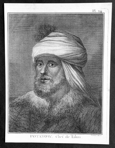
1778 Capt. Cook Antique Print Portrait of Chief Potatau of Punaauia, Tahiti 1773
- Title : Potatow, Chef de Tahiti
- Ref : 31772
- Size: 10in x 8in (255mm x 205mm)
- Date : 1778
- Condition: (A+) Fine Condition
Description:
This fine original copper-plate engraved antique print, a portrait of Chief Potatau of Punaauia in Tahiti, French Polynesia, met by Captain James Cook during his 2nd Voyage of Discovery in the South Seas in 1773, was engraved by Robert Benard - after William Hodges - and was published in the 1778 French edition of Capt. James Cooks 2nd Voyage of Discovery to the South Seas A voyage towards the South Pole, and round the World. Performed in His Majestys ships the Resolution and Adventure, in the years 1772, 1773, 1774, and 1775..... Paris : Hotel de Thou ......1778
Cooks Biography............George Vancouver (midshipman, of later fame) meanwhile, stayed behind to contemplate the role of the red feather in Tahitian society. It happened that Chief Potatau consulted with his wife on how they might obtain some of Cook\'s Oora and according to the plan that somehow reached Georges ears, she would go to Cook in his cabin and offer her services in return for said feathers. But the Captain was unswayed. It was just as well that Georges father was absent on this particular occasion, for he would only have been upset. As it was, his sleep was often disturbed by the sailors running all over the ship with their sexual partners at any hour of the night.
Such was Tahitian zeal for red feathers, Clerke remarked, that they gladly engaged in rather unhallow\'d rites for the sacred jewels in order to offer Propitiation to their Jolly Gods. Such was the maritime zeal for the Tahitian religion that the sailors fairly plundered the ship of its treasures; feathers were ripped from lovely Tongan garments and from delicate fretwork on coconuts; sailors even dyed plain feathers red. Thus valuable artifacts of the South Seas were undone. Nevertheless, among the treasures that came aboard were Potatau\'s monstrous helmets of war of five feet high and several handsome mourning dresses to become in due course part of the collections of ethnology in the Ashmolean Museum and the Bishop Museum. Besides the red feathers, the abundance of pork also attracted the girls; they consumed incredible quantities, reported George, because, as members of a poor class of Tahitians, they were denied pork in their own households. Such were the quantities they consumed, added George with a certain delicacy, that of a sudden they suffered the inconvenience of restlessness, and when they were refused the attention of their lovers, the very decks began to resemble the paths in the islands.........
General Definitions:
Paper thickness and quality: - Heavy and stable
Paper color : - off white
Age of map color: -
Colors used: -
General color appearance: -
Paper size: - 10in x 8in (255mm x 205mm)
Plate size: - 9 1/2in x 7 1/4in (240mm x 185mm)
Margins: - Min 1/2in (12mm)
Imperfections:
Margins: - Light soiling in margins
Plate area: - None
Verso: - None
Background:
Tahiti previously also known as Otaheite is the largest island in the Windward group of French Polynesia. The island is located in the archipelago of the Society Islands in the central Southern Pacific Ocean.
The first European to have visited Tahiti according to existing records was lieutenant Samuel Wallis, who was circumnavigating the globe in HMS Dolphin, sighting the island on 18 June 1767, and eventually harboring in Matavai Bay. This bay was situated on the territory of the chiefdom of Pare-Arue, governed by Tu (Tu-nui-e-a a-i-te-Atua) and his regent Tutaha, and the chiefdom of Ha apape, governed by Amo and his wife Oberea (Purea). Wallis named the island King Georges Island. The first contacts were difficult, since on the 24 and 26 June 1767, Tahitian warriors in canoes showed aggression towards the British, hurling stones from their slings. In retaliation, the British sailors opened fire on the warriors in the canoes and on the hills. In reaction to this powerful counter-attack, the Tahitians laid down peace offerings for the British. Following this episode, Samuel Wallis was able to establish cordial relations with the female chieftain “Oberea “ (Purea) and remained on the island until 27 July 1767.
In July 1768, Captain James Cook was commissioned by the Royal Society and on orders from the Lords Commissioners of the Admiralty to observe the transit of Venus across the sun, a phenomenon that would be visible from Tahiti on 3 June 1769. He arrived in Tahitis Matavai Bay, commanding the HMS Endeavour on 12 April 1769. On 14 April, Cook met with Tutaha and Tepau. On 15 April, Cook picked the site for a fortified camp at Point Venus along with Banks, Parkinson, Daniel Solander, to protect Charles Greens observatory. The length of stay enabled them to undertake for the first time real ethnographic and scientific observations of the island. Assisted by the botanist Joseph Banks, and by the artist Sydney Parkinson, Cook gathered valuable information on the fauna and flora, as well as the native society, language and customs, including the proper name of the island, Otaheite. On 28 April, Cook met Purea and Tupaia, and Tupaia befriended Banks following the transit. On 21 June, Amo visited Cook, and then on 25 June, Pohuetea visited, signifying another chief seeking to ally himself with the British.
Cook and Banks circumnavigated the island from 26 June to 1 July. On the exploration, they met Ahio, chief of Ha apaiano o or Papenoo, Rita, chief of Hitia a, Pahairro, chief of Pueu, Vehiatua, chief of Tautra, Matahiapo, chief of Teahupo o, Tutea, chief of Vaira o, and Moe, chief of Afa Ahiti. In Papara, guided by Tupaia, they investigated the ruins of Mahaiatea marae, an impressive structure containing a stone pyramid or ahu, measuring 44 feet high, 267 feet long and 87 feet wide. Cook and the Endeavour departed Tahiti on 13 July 1769, taking Raiatean navigator Tupaia along for his geographic knowledge of the islands.
Cook returned to Tahiti between 15 August and 1 September 1773, greeted by the chiefs Tai and Puhi, besides the youg ari i Vehiatua II and his stepfather Ti itorea. Cook anchored in Vaitepiha Bay before returning to Point Venus where he met Tu, the paramount chief. Cook picked up two passengers from Tahiti during this trip, Porea and Mai, with Hitihiti later replacing Porea when Cook stopped at Raiatea. Cook took Hitihiti to Tahiti on 22 April, during his return leg. Then, Cook departed Tahiti on 14 May 1774.
During his final visit, Cook returned Mai to Tahiti on 12 Aug. 1777, after Mais long visit in England. Cook also brought two Maori from Queen Charlotte Sound, Te Weherua and Koa. Cook first harbored in Vaitepiha Bay, where he visited Vehiatua II s funeral bier and the prefabricated Spanish mission house. Cook also met Vehiatua III, and inscribed on the back of the Spanish cross, Georgius tertius Rex Annis 1767, 69, 73, 74 & 77, as a counterpoint to Christus Vincit Carolus III imperat 1774 on the front. On 23 Aug., Cook sailed for Matavai Bay, where he met Tu, his father Teu, his mother Tetupaia, his brothers Ari ipaea and Vaetua, and his sisters Ari ipaea-vahine, Tetua-te-ahamai, and Auo. Cook also observed a human sacrifice, taata tapu, at the Utu-ai-mahurau marae, and 49 skulls from previous victims.
On 29 Sept. 1777, Cook sailed for Papetoai Bay on Moorea. Cook met Mahine in an act of friendship on 3 Oct., though he was an enemy of Tu. When a goat kid was stolen on 6 Oct., Cook in a rampage, ordered the burning of houses and canoes until it was returned. Cook sailed for Huahine on 11 Oct., Raiatea on 2 Nov., and Borabora on 7 Dec.
On 26 October 1788, HMS Bounty, under the command of Captain William Bligh, landed in Tahiti with the mission of carrying Tahitian breadfruit trees (Tahitian: uru) to the Caribbean. Sir Joseph Banks, the botanist from James Cooks first expedition, had concluded that this plant would be ideal to feed the African slaves working in the Caribbean plantations at very little cost. The crew remained in Tahiti for about five months, the time needed to transplant the seedlings of the trees. Three weeks after leaving Tahiti, on 28 April 1789, the crew mutinied on the initiative of Fletcher Christian. The mutineers seized the ship and set the captain and most of those members of the crew who remained loyal to him adrift in a ships boat. A group of mutineers then went back to settle in Tahiti.
Although various explorers had refused to get involved in tribal conflicts, the mutineers from the Bounty offered their services as mercenaries and furnished arms to the family which became the Pōmare Dynasty. The chief Tū knew how to use their presence in the harbours favoured by sailors to his advantage. As a result of his alliance with the mutineers, he succeeded in considerably increasing his supremacy over the island of Tahiti.
William Hodges RA 1744 – 1797 was an English painter. He was a member of James Cooks second voyage to the Pacific Ocean, and is best known for the sketches and paintings of locations he visited on that voyage, including Table Bay, Tahiti, Easter Island, and the Antarctic.
Between 1772 and 1775 Hodges accompanied James Cook to the Pacific as the expeditions artist. Many of his sketches and wash paintings were adapted as engravings in the original published edition of Cooks journals from the voyage.
Most of the large-scale landscape oil paintings from his Pacific travels for which Hodges is best known were finished after his return to London; he received a salary from the Admiralty for the purposes of completing them. These paintings depicted a stronger light and shadow than had been usual in European landscape tradition. Contemporary art critics complained that his use of light and colour contrasts gave his paintings a rough and unfinished appearance.
Hodges also produced many valuable portrait sketches of Pacific islanders and scenes from the voyage involving members of the expedition..
Robert Bénard 1734 – 1777 was an 18th-century French engraver.
Specialized in the technique of engraving, Robert Ménard is mainly famous for having supplied a significant amount of plates (at least 1,800) to the Encyclopédie by Diderot & d\'Alembert from 1751.
Later, publisher Charles-Joseph Panckoucke reused many of his productions to illustrate the works of his catalog.
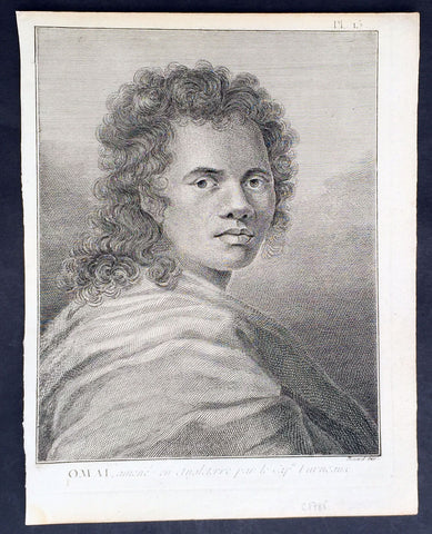
1778 Capt. Cook Antique Print Portrait of Omai of Raiatea Island - Furneaux 1773
- Title : Omai, amene en Angleterre par le Cap. Furneaux (Omai, brought to England by Captain Furneaux)
- Ref : 21334
- Size: 10in x 8in (255mm x 205mm)
- Date : 1778
- Condition: (A+) Fine Condition
Description:
This fine original copper-plate engraved antique print, a portrait of Mai or Omai of Raiatea (Ulietea) Island, used by Captain James Cook & Commander Tobias Furneaux as an interpreter during his 2nd Voyage of Discovery in the South Seas, and later taken to England by Furneaux, was engraved by Robert Benard - after William Hodges - and was published in the 1778 French edition of Capt. James Cooks 2nd Voyage of Discovery to the South Seas A voyage towards the South Pole, and round the World. Performed in His Majestys ships the Resolution and Adventure, in the years 1772, 1773, 1774, and 1775..... Paris : Hotel de Thou ......1778
General Definitions:
Paper thickness and quality: - Heavy and stable
Paper color : - off white
Age of map color: -
Colors used: -
General color appearance: -
Paper size: - 10in x 8in (255mm x 205mm)
Plate size: - 9 1/2in x 7 1/4in (240mm x 185mm)
Margins: - Min 1/2in (12mm)
Imperfections:
Margins: - Light soiling in margins
Plate area: - None
Verso: - None
Background:
Mai mistakenly known as Omai 1751-1780, was a young Raiatean man who became the second Pacific Islander to visit Europe, after Ahu-toru who was brought to Paris by Bougainville in 1768.
Mai described himself as a hoa, chiefly attendant, the son of a Raiatea landowner. His father was killed by Punis Borabora warriors. Fleeing to Tahiti, Mai was wounded in the encounter with the Dolphin in 1767. Mai then became an apprentice to a priest. Returning to Raiatea, he was captured and taken to Borabora. Narrowly escaping death there, he escaped to Raiatea (Huahine).
Omai met Samuel Wallis in 1767 and Captain James Cook in 1769 in Tahiti. In August 1773 he embarked from Raiatea (Huahine) on the British ship HMS Adventure, commanded by Commander Tobias Furneaux, which had previously touched at Tahiti as part of James Cook\\\'s second voyage of discovery in the Pacific. Omai traveled to Europe on Adventure, arriving at London in October 1774 where he was introduced into British society by the naturalist Sir Joseph Banks (whom he had also met during Cook\\\'s first voyage).
During his two-year stay in England, Omai became much admired within London high society. Renowned for his charm, quick wit and exotic good looks, he quickly became a favourite of the aristocratic elite. Banks regularly invited Omai to dine with the Royal Society and arranged meetings with notable celebrities of the time, including Lord Sandwich, Dr Samuel Johnson, Frances Burney, and Anna Seward, among others. Richard Holmes remarks that Omai\\\'s idiosyncratic behaviour and distinctive bow were widely celebrated. Indeed, during one famed meeting with King George III at Kew, Omai is said to have delivered his bow then grasped the King\\\'s hand, declaring, How do, King Tosh!
His portrait was painted by Sir Joshua Reynolds among others, and his journey to England and subsequent return to Tahiti with Cook on his third voyage in 1776 became the subject of a theatrical production, written and directed by the dramatist John O Keefe, entitled Omai – A Voyage ‘round the World that was performed during the 1785 Christmas season at London’s Theatre Royal in Covent Garden.
Omai returned to Raiatea (Huahine) in August 1777 and was settled with a European-style house, furniture, vineyard and two Maori boys as his servants. During the Bounty\\\'s visit to Tahiti in 1789, Captain Bligh was told Omai had died about two and a half years after Cook\\\'s departure in November 1777.
Raiatea, is the second largest of the Society Islands, after Tahiti, in French Polynesia. The island is widely regarded as the centre of the eastern islands in ancient Polynesia and it is likely that the organised migrations to Hawaii, Aotearoa and other parts of East Polynesia started at Raiātea.
A traditional name for the island is Havaii, homeland of the Māori people.
The first European to record sighting Ra iātea was Pedro Fernandes de Queirós in 1606; it was charted as La Fugitiva The Polynesian navigator, Tupaia, who sailed with explorer James Cook, was born in Raiātea around 1725.
Cook visited Raiatea in 1769 and again in 1773-1774. Omai (c.1751-1780), another young man from Raiātea, traveled with the European explorers to London in 1774 and also served as an interpreter to Captain Cook on his second and third journey.
King Tamatoa VI was the last monarch, reigning from 1884-1888.
Tahiti previously also known as Otaheite is the largest island in the Windward group of French Polynesia. The island is located in the archipelago of the Society Islands in the central Southern Pacific Ocean.
The first European to have visited Tahiti according to existing records was lieutenant Samuel Wallis, who was circumnavigating the globe in HMS Dolphin, sighting the island on 18 June 1767, and eventually harboring in Matavai Bay. This bay was situated on the territory of the chiefdom of Pare-Arue, governed by Tu (Tu-nui-e-a a-i-te-Atua) and his regent Tutaha, and the chiefdom of Ha apape, governed by Amo and his wife Oberea (Purea). Wallis named the island King Georges Island. The first contacts were difficult, since on the 24 and 26 June 1767, Tahitian warriors in canoes showed aggression towards the British, hurling stones from their slings. In retaliation, the British sailors opened fire on the warriors in the canoes and on the hills. In reaction to this powerful counter-attack, the Tahitians laid down peace offerings for the British. Following this episode, Samuel Wallis was able to establish cordial relations with the female chieftain “Oberea “ (Purea) and remained on the island until 27 July 1767.
In July 1768, Captain James Cook was commissioned by the Royal Society and on orders from the Lords Commissioners of the Admiralty to observe the transit of Venus across the sun, a phenomenon that would be visible from Tahiti on 3 June 1769. He arrived in Tahitis Matavai Bay, commanding the HMS Endeavour on 12 April 1769. On 14 April, Cook met with Tutaha and Tepau. On 15 April, Cook picked the site for a fortified camp at Point Venus along with Banks, Parkinson, Daniel Solander, to protect Charles Greens observatory. The length of stay enabled them to undertake for the first time real ethnographic and scientific observations of the island. Assisted by the botanist Joseph Banks, and by the artist Sydney Parkinson, Cook gathered valuable information on the fauna and flora, as well as the native society, language and customs, including the proper name of the island, Otaheite. On 28 April, Cook met Purea and Tupaia, and Tupaia befriended Banks following the transit. On 21 June, Amo visited Cook, and then on 25 June, Pohuetea visited, signifying another chief seeking to ally himself with the British.
Cook and Banks circumnavigated the island from 26 June to 1 July. On the exploration, they met Ahio, chief of Ha apaiano o or Papenoo, Rita, chief of Hitia a, Pahairro, chief of Pueu, Vehiatua, chief of Tautra, Matahiapo, chief of Teahupo o, Tutea, chief of Vaira o, and Moe, chief of Afa Ahiti. In Papara, guided by Tupaia, they investigated the ruins of Mahaiatea marae, an impressive structure containing a stone pyramid or ahu, measuring 44 feet high, 267 feet long and 87 feet wide. Cook and the Endeavour departed Tahiti on 13 July 1769, taking Raiatean navigator Tupaia along for his geographic knowledge of the islands.
Cook returned to Tahiti between 15 August and 1 September 1773, greeted by the chiefs Tai and Puhi, besides the youg ari i Vehiatua II and his stepfather Ti itorea. Cook anchored in Vaitepiha Bay before returning to Point Venus where he met Tu, the paramount chief. Cook picked up two passengers from Tahiti during this trip, Porea and Mai, with Hitihiti later replacing Porea when Cook stopped at Raiatea. Cook took Hitihiti to Tahiti on 22 April, during his return leg. Then, Cook departed Tahiti on 14 May 1774.
During his final visit, Cook returned Mai to Tahiti on 12 Aug. 1777, after Mais long visit in England. Cook also brought two Maori from Queen Charlotte Sound, Te Weherua and Koa. Cook first harbored in Vaitepiha Bay, where he visited Vehiatua II s funeral bier and the prefabricated Spanish mission house. Cook also met Vehiatua III, and inscribed on the back of the Spanish cross, Georgius tertius Rex Annis 1767, 69, 73, 74 & 77, as a counterpoint to Christus Vincit Carolus III imperat 1774 on the front. On 23 Aug., Cook sailed for Matavai Bay, where he met Tu, his father Teu, his mother Tetupaia, his brothers Ari ipaea and Vaetua, and his sisters Ari ipaea-vahine, Tetua-te-ahamai, and Auo. Cook also observed a human sacrifice, taata tapu, at the Utu-ai-mahurau marae, and 49 skulls from previous victims.
On 29 Sept. 1777, Cook sailed for Papetoai Bay on Moorea. Cook met Mahine in an act of friendship on 3 Oct., though he was an enemy of Tu. When a goat kid was stolen on 6 Oct., Cook in a rampage, ordered the burning of houses and canoes until it was returned. Cook sailed for Huahine on 11 Oct., Raiatea on 2 Nov., and Borabora on 7 Dec.
On 26 October 1788, HMS Bounty, under the command of Captain William Bligh, landed in Tahiti with the mission of carrying Tahitian breadfruit trees (Tahitian: uru) to the Caribbean. Sir Joseph Banks, the botanist from James Cooks first expedition, had concluded that this plant would be ideal to feed the African slaves working in the Caribbean plantations at very little cost. The crew remained in Tahiti for about five months, the time needed to transplant the seedlings of the trees. Three weeks after leaving Tahiti, on 28 April 1789, the crew mutinied on the initiative of Fletcher Christian. The mutineers seized the ship and set the captain and most of those members of the crew who remained loyal to him adrift in a ships boat. A group of mutineers then went back to settle in Tahiti.
Although various explorers had refused to get involved in tribal conflicts, the mutineers from the Bounty offered their services as mercenaries and furnished arms to the family which became the Pōmare Dynasty. The chief Tū knew how to use their presence in the harbours favoured by sailors to his advantage. As a result of his alliance with the mutineers, he succeeded in considerably increasing his supremacy over the island of Tahiti.
William Hodges RA 1744 – 1797 was an English painter. He was a member of James Cooks second voyage to the Pacific Ocean, and is best known for the sketches and paintings of locations he visited on that voyage, including Table Bay, Tahiti, Easter Island, and the Antarctic.
Between 1772 and 1775 Hodges accompanied James Cook to the Pacific as the expeditions artist. Many of his sketches and wash paintings were adapted as engravings in the original published edition of Cooks journals from the voyage.
Most of the large-scale landscape oil paintings from his Pacific travels for which Hodges is best known were finished after his return to London; he received a salary from the Admiralty for the purposes of completing them. These paintings depicted a stronger light and shadow than had been usual in European landscape tradition. Contemporary art critics complained that his use of light and colour contrasts gave his paintings a rough and unfinished appearance.
Hodges also produced many valuable portrait sketches of Pacific islanders and scenes from the voyage involving members of the expedition..
Robert Bénard 1734 – 1777 was an 18th-century French engraver.
Specialized in the technique of engraving, Robert Ménard is mainly famous for having supplied a significant amount of plates (at least 1,800) to the Encyclopédie by Diderot & d\'Alembert from 1751.
Later, publisher Charles-Joseph Panckoucke reused many of his productions to illustrate the works of his catalog.
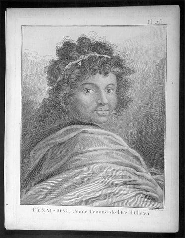
1778 Capt. Cook Antique Print of Princess Tynai-Mai of Raiatea Island in 1773
- Title : Tynai-Mai, Jeune Femme de L Isle d Ulietea
- Ref : 16357
- Size: 10in x 8in (255mm x 205mm)
- Date : 1778
- Condition: (A+) Fine Condition
Description:
This fine original copper-plate engraved antique print, a portrait of Princess Tynai-Mai of Raiatea (Ulietea) Island, the second largest of the Society Islands, after Tahiti, in French Polynesia, met by Captain James Cook during his 2nd Voyage of Discovery in 1773, was engraved by Robert Benard - after William Hodges - and was published in the 1778 French edition of Capt. James Cooks 2nd Voyage of Discovery to the South Seas A voyage towards the South Pole, and round the World. Performed in His Majestys ships the Resolution and Adventure, in the years 1772, 1773, 1774, and 1775..... Paris : Hotel de Thou ......1778
General Definitions:
Paper thickness and quality: - Heavy and stable
Paper color : - off white
Age of map color: -
Colors used: -
General color appearance: -
Paper size: - 10in x 8in (255mm x 205mm)
Plate size: - 9 1/2in x 7 1/4in (240mm x 185mm)
Margins: - Min 1/2in (12mm)
Imperfections:
Margins: - Light soiling in margins
Plate area: - None
Verso: - None
Background:
Raiatea, is the second largest of the Society Islands, after Tahiti, in French Polynesia. The island is widely regarded as the centre of the eastern islands in ancient Polynesia and it is likely that the organised migrations to Hawaii, Aotearoa and other parts of East Polynesia started at Raiātea.
A traditional name for the island is Havaii, homeland of the Māori people.
The first European to record sighting Ra iātea was Pedro Fernandes de Queirós in 1606; it was charted as La Fugitiva The Polynesian navigator, Tupaia, who sailed with explorer James Cook, was born in Raiātea around 1725.
Cook visited Raiatea in 1769 and again in 1773-1774. Omai (c.1751-1780), another young man from Raiātea, traveled with the European explorers to London in 1774 and also served as an interpreter to Captain Cook on his second and third journey.
King Tamatoa VI was the last monarch, reigning from 1884-1888.
Tahiti previously also known as Otaheite is the largest island in the Windward group of French Polynesia. The island is located in the archipelago of the Society Islands in the central Southern Pacific Ocean.
The first European to have visited Tahiti according to existing records was lieutenant Samuel Wallis, who was circumnavigating the globe in HMS Dolphin, sighting the island on 18 June 1767, and eventually harboring in Matavai Bay. This bay was situated on the territory of the chiefdom of Pare-Arue, governed by Tu (Tu-nui-e-a a-i-te-Atua) and his regent Tutaha, and the chiefdom of Ha apape, governed by Amo and his wife Oberea (Purea). Wallis named the island King Georges Island. The first contacts were difficult, since on the 24 and 26 June 1767, Tahitian warriors in canoes showed aggression towards the British, hurling stones from their slings. In retaliation, the British sailors opened fire on the warriors in the canoes and on the hills. In reaction to this powerful counter-attack, the Tahitians laid down peace offerings for the British. Following this episode, Samuel Wallis was able to establish cordial relations with the female chieftain “Oberea “ (Purea) and remained on the island until 27 July 1767.
In July 1768, Captain James Cook was commissioned by the Royal Society and on orders from the Lords Commissioners of the Admiralty to observe the transit of Venus across the sun, a phenomenon that would be visible from Tahiti on 3 June 1769. He arrived in Tahitis Matavai Bay, commanding the HMS Endeavour on 12 April 1769. On 14 April, Cook met with Tutaha and Tepau. On 15 April, Cook picked the site for a fortified camp at Point Venus along with Banks, Parkinson, Daniel Solander, to protect Charles Greens observatory. The length of stay enabled them to undertake for the first time real ethnographic and scientific observations of the island. Assisted by the botanist Joseph Banks, and by the artist Sydney Parkinson, Cook gathered valuable information on the fauna and flora, as well as the native society, language and customs, including the proper name of the island, Otaheite. On 28 April, Cook met Purea and Tupaia, and Tupaia befriended Banks following the transit. On 21 June, Amo visited Cook, and then on 25 June, Pohuetea visited, signifying another chief seeking to ally himself with the British.
Cook and Banks circumnavigated the island from 26 June to 1 July. On the exploration, they met Ahio, chief of Ha apaiano o or Papenoo, Rita, chief of Hitia a, Pahairro, chief of Pueu, Vehiatua, chief of Tautra, Matahiapo, chief of Teahupo o, Tutea, chief of Vaira o, and Moe, chief of Afa Ahiti. In Papara, guided by Tupaia, they investigated the ruins of Mahaiatea marae, an impressive structure containing a stone pyramid or ahu, measuring 44 feet high, 267 feet long and 87 feet wide. Cook and the Endeavour departed Tahiti on 13 July 1769, taking Raiatean navigator Tupaia along for his geographic knowledge of the islands.
Cook returned to Tahiti between 15 August and 1 September 1773, greeted by the chiefs Tai and Puhi, besides the youg ari i Vehiatua II and his stepfather Ti itorea. Cook anchored in Vaitepiha Bay before returning to Point Venus where he met Tu, the paramount chief. Cook picked up two passengers from Tahiti during this trip, Porea and Mai, with Hitihiti later replacing Porea when Cook stopped at Raiatea. Cook took Hitihiti to Tahiti on 22 April, during his return leg. Then, Cook departed Tahiti on 14 May 1774.
During his final visit, Cook returned Mai to Tahiti on 12 Aug. 1777, after Mais long visit in England. Cook also brought two Maori from Queen Charlotte Sound, Te Weherua and Koa. Cook first harbored in Vaitepiha Bay, where he visited Vehiatua II s funeral bier and the prefabricated Spanish mission house. Cook also met Vehiatua III, and inscribed on the back of the Spanish cross, Georgius tertius Rex Annis 1767, 69, 73, 74 & 77, as a counterpoint to Christus Vincit Carolus III imperat 1774 on the front. On 23 Aug., Cook sailed for Matavai Bay, where he met Tu, his father Teu, his mother Tetupaia, his brothers Ari ipaea and Vaetua, and his sisters Ari ipaea-vahine, Tetua-te-ahamai, and Auo. Cook also observed a human sacrifice, taata tapu, at the Utu-ai-mahurau marae, and 49 skulls from previous victims.
On 29 Sept. 1777, Cook sailed for Papetoai Bay on Moorea. Cook met Mahine in an act of friendship on 3 Oct., though he was an enemy of Tu. When a goat kid was stolen on 6 Oct., Cook in a rampage, ordered the burning of houses and canoes until it was returned. Cook sailed for Huahine on 11 Oct., Raiatea on 2 Nov., and Borabora on 7 Dec.
On 26 October 1788, HMS Bounty, under the command of Captain William Bligh, landed in Tahiti with the mission of carrying Tahitian breadfruit trees (Tahitian: uru) to the Caribbean. Sir Joseph Banks, the botanist from James Cooks first expedition, had concluded that this plant would be ideal to feed the African slaves working in the Caribbean plantations at very little cost. The crew remained in Tahiti for about five months, the time needed to transplant the seedlings of the trees. Three weeks after leaving Tahiti, on 28 April 1789, the crew mutinied on the initiative of Fletcher Christian. The mutineers seized the ship and set the captain and most of those members of the crew who remained loyal to him adrift in a ships boat. A group of mutineers then went back to settle in Tahiti.
Although various explorers had refused to get involved in tribal conflicts, the mutineers from the Bounty offered their services as mercenaries and furnished arms to the family which became the Pōmare Dynasty. The chief Tū knew how to use their presence in the harbours favoured by sailors to his advantage. As a result of his alliance with the mutineers, he succeeded in considerably increasing his supremacy over the island of Tahiti.
William Hodges RA 1744 – 1797 was an English painter. He was a member of James Cooks second voyage to the Pacific Ocean, and is best known for the sketches and paintings of locations he visited on that voyage, including Table Bay, Tahiti, Easter Island, and the Antarctic.
Between 1772 and 1775 Hodges accompanied James Cook to the Pacific as the expeditions artist. Many of his sketches and wash paintings were adapted as engravings in the original published edition of Cooks journals from the voyage.
Most of the large-scale landscape oil paintings from his Pacific travels for which Hodges is best known were finished after his return to London; he received a salary from the Admiralty for the purposes of completing them. These paintings depicted a stronger light and shadow than had been usual in European landscape tradition. Contemporary art critics complained that his use of light and colour contrasts gave his paintings a rough and unfinished appearance.
Hodges also produced many valuable portrait sketches of Pacific islanders and scenes from the voyage involving members of the expedition..
Robert Bénard 1734 – 1777 was an 18th-century French engraver.
Specialized in the technique of engraving, Robert Ménard is mainly famous for having supplied a significant amount of plates (at least 1,800) to the Encyclopédie by Diderot & d\'Alembert from 1751.
Later, publisher Charles-Joseph Panckoucke reused many of his productions to illustrate the works of his catalog.
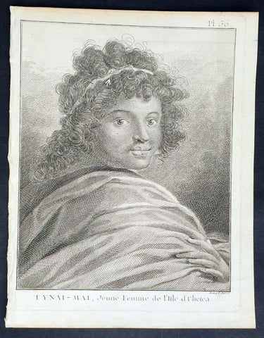
1778 Capt. Cook Antique Print of Princess Tynai-Mai of Raiatea Island in 1773
- Title : Tynai-Mai, Jeune Femme de L Isle d Ulietea
- Ref : 21319
- Size: 10in x 8in (255mm x 205mm)
- Date : 1778
- Condition: (A+) Fine Condition
Description:
This fine original copper-plate engraved antique print, a portrait of Princess Tynai-Mai of Raiatea (Ulietea) Island, the second largest of the Society Islands, after Tahiti, in French Polynesia, met by Captain James Cook during his 2nd Voyage of Discovery in 1773, was engraved by Robert Benard - after William Hodges - and was published in the 1778 French edition of Capt. James Cooks 2nd Voyage of Discovery to the South Seas A voyage towards the South Pole, and round the World. Performed in His Majestys ships the Resolution and Adventure, in the years 1772, 1773, 1774, and 1775..... Paris : Hotel de Thou ......1778
General Definitions:
Paper thickness and quality: - Heavy and stable
Paper color : - off white
Age of map color: -
Colors used: -
General color appearance: -
Paper size: - 10in x 8in (255mm x 205mm)
Plate size: - 9 1/2in x 7 1/4in (240mm x 185mm)
Margins: - Min 1/2in (12mm)
Imperfections:
Margins: - Light soiling in margins
Plate area: - None
Verso: - None
Background:
Raiatea, is the second largest of the Society Islands, after Tahiti, in French Polynesia. The island is widely regarded as the centre of the eastern islands in ancient Polynesia and it is likely that the organised migrations to Hawaii, Aotearoa and other parts of East Polynesia started at Raiātea.
A traditional name for the island is Havaii, homeland of the Māori people.
The first European to record sighting Ra iātea was Pedro Fernandes de Queirós in 1606; it was charted as La Fugitiva The Polynesian navigator, Tupaia, who sailed with explorer James Cook, was born in Raiātea around 1725.
Cook visited Raiatea in 1769 and again in 1773-1774. Omai (c.1751-1780), another young man from Raiātea, traveled with the European explorers to London in 1774 and also served as an interpreter to Captain Cook on his second and third journey.
King Tamatoa VI was the last monarch, reigning from 1884-1888.
Tahiti previously also known as Otaheite is the largest island in the Windward group of French Polynesia. The island is located in the archipelago of the Society Islands in the central Southern Pacific Ocean.
The first European to have visited Tahiti according to existing records was lieutenant Samuel Wallis, who was circumnavigating the globe in HMS Dolphin, sighting the island on 18 June 1767, and eventually harboring in Matavai Bay. This bay was situated on the territory of the chiefdom of Pare-Arue, governed by Tu (Tu-nui-e-a a-i-te-Atua) and his regent Tutaha, and the chiefdom of Ha apape, governed by Amo and his wife Oberea (Purea). Wallis named the island King Georges Island. The first contacts were difficult, since on the 24 and 26 June 1767, Tahitian warriors in canoes showed aggression towards the British, hurling stones from their slings. In retaliation, the British sailors opened fire on the warriors in the canoes and on the hills. In reaction to this powerful counter-attack, the Tahitians laid down peace offerings for the British. Following this episode, Samuel Wallis was able to establish cordial relations with the female chieftain “Oberea “ (Purea) and remained on the island until 27 July 1767.
In July 1768, Captain James Cook was commissioned by the Royal Society and on orders from the Lords Commissioners of the Admiralty to observe the transit of Venus across the sun, a phenomenon that would be visible from Tahiti on 3 June 1769. He arrived in Tahitis Matavai Bay, commanding the HMS Endeavour on 12 April 1769. On 14 April, Cook met with Tutaha and Tepau. On 15 April, Cook picked the site for a fortified camp at Point Venus along with Banks, Parkinson, Daniel Solander, to protect Charles Greens observatory. The length of stay enabled them to undertake for the first time real ethnographic and scientific observations of the island. Assisted by the botanist Joseph Banks, and by the artist Sydney Parkinson, Cook gathered valuable information on the fauna and flora, as well as the native society, language and customs, including the proper name of the island, Otaheite. On 28 April, Cook met Purea and Tupaia, and Tupaia befriended Banks following the transit. On 21 June, Amo visited Cook, and then on 25 June, Pohuetea visited, signifying another chief seeking to ally himself with the British.
Cook and Banks circumnavigated the island from 26 June to 1 July. On the exploration, they met Ahio, chief of Ha apaiano o or Papenoo, Rita, chief of Hitia a, Pahairro, chief of Pueu, Vehiatua, chief of Tautra, Matahiapo, chief of Teahupo o, Tutea, chief of Vaira o, and Moe, chief of Afa Ahiti. In Papara, guided by Tupaia, they investigated the ruins of Mahaiatea marae, an impressive structure containing a stone pyramid or ahu, measuring 44 feet high, 267 feet long and 87 feet wide. Cook and the Endeavour departed Tahiti on 13 July 1769, taking Raiatean navigator Tupaia along for his geographic knowledge of the islands.
Cook returned to Tahiti between 15 August and 1 September 1773, greeted by the chiefs Tai and Puhi, besides the youg ari i Vehiatua II and his stepfather Ti itorea. Cook anchored in Vaitepiha Bay before returning to Point Venus where he met Tu, the paramount chief. Cook picked up two passengers from Tahiti during this trip, Porea and Mai, with Hitihiti later replacing Porea when Cook stopped at Raiatea. Cook took Hitihiti to Tahiti on 22 April, during his return leg. Then, Cook departed Tahiti on 14 May 1774.
During his final visit, Cook returned Mai to Tahiti on 12 Aug. 1777, after Mais long visit in England. Cook also brought two Maori from Queen Charlotte Sound, Te Weherua and Koa. Cook first harbored in Vaitepiha Bay, where he visited Vehiatua II s funeral bier and the prefabricated Spanish mission house. Cook also met Vehiatua III, and inscribed on the back of the Spanish cross, Georgius tertius Rex Annis 1767, 69, 73, 74 & 77, as a counterpoint to Christus Vincit Carolus III imperat 1774 on the front. On 23 Aug., Cook sailed for Matavai Bay, where he met Tu, his father Teu, his mother Tetupaia, his brothers Ari ipaea and Vaetua, and his sisters Ari ipaea-vahine, Tetua-te-ahamai, and Auo. Cook also observed a human sacrifice, taata tapu, at the Utu-ai-mahurau marae, and 49 skulls from previous victims.
On 29 Sept. 1777, Cook sailed for Papetoai Bay on Moorea. Cook met Mahine in an act of friendship on 3 Oct., though he was an enemy of Tu. When a goat kid was stolen on 6 Oct., Cook in a rampage, ordered the burning of houses and canoes until it was returned. Cook sailed for Huahine on 11 Oct., Raiatea on 2 Nov., and Borabora on 7 Dec.
On 26 October 1788, HMS Bounty, under the command of Captain William Bligh, landed in Tahiti with the mission of carrying Tahitian breadfruit trees (Tahitian: uru) to the Caribbean. Sir Joseph Banks, the botanist from James Cooks first expedition, had concluded that this plant would be ideal to feed the African slaves working in the Caribbean plantations at very little cost. The crew remained in Tahiti for about five months, the time needed to transplant the seedlings of the trees. Three weeks after leaving Tahiti, on 28 April 1789, the crew mutinied on the initiative of Fletcher Christian. The mutineers seized the ship and set the captain and most of those members of the crew who remained loyal to him adrift in a ships boat. A group of mutineers then went back to settle in Tahiti.
Although various explorers had refused to get involved in tribal conflicts, the mutineers from the Bounty offered their services as mercenaries and furnished arms to the family which became the Pōmare Dynasty. The chief Tū knew how to use their presence in the harbours favoured by sailors to his advantage. As a result of his alliance with the mutineers, he succeeded in considerably increasing his supremacy over the island of Tahiti.
William Hodges RA 1744 – 1797 was an English painter. He was a member of James Cooks second voyage to the Pacific Ocean, and is best known for the sketches and paintings of locations he visited on that voyage, including Table Bay, Tahiti, Easter Island, and the Antarctic.
Between 1772 and 1775 Hodges accompanied James Cook to the Pacific as the expeditions artist. Many of his sketches and wash paintings were adapted as engravings in the original published edition of Cooks journals from the voyage.
Most of the large-scale landscape oil paintings from his Pacific travels for which Hodges is best known were finished after his return to London; he received a salary from the Admiralty for the purposes of completing them. These paintings depicted a stronger light and shadow than had been usual in European landscape tradition. Contemporary art critics complained that his use of light and colour contrasts gave his paintings a rough and unfinished appearance.
Hodges also produced many valuable portrait sketches of Pacific islanders and scenes from the voyage involving members of the expedition..
Robert Bénard 1734 – 1777 was an 18th-century French engraver.
Specialized in the technique of engraving, Robert Ménard is mainly famous for having supplied a significant amount of plates (at least 1,800) to the Encyclopédie by Diderot & d\'Alembert from 1751.
Later, publisher Charles-Joseph Panckoucke reused many of his productions to illustrate the works of his catalog.
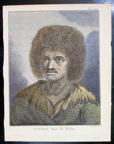
1774 Capt. Cook Antique Print a Portrait of Chief Tynah, Otoo of Tahiti in 1769
- Title : Otoo, Roi de Tahiti
- Ref : 21341
- Size: 10in x 8in (255mm x 205mm)
- Date : 1774
- Condition: (A+) Fine Condition
Description:
This fine original copper-plate engraved antique print a portrait of Chief Tynah (Otoo) of Tahiti Island, met by Captain James Cook during his 1st Voyage of Discovery in 1769, was engraved by Robert Benard - after Sydney Parkinson - and was published in the 1774 French edition of Capt. James Cooks 1st Voyage of Discovery to the South Seas by John Hawkesworth in An Account of the Voyages Undertaken by the Order of His Present Majesty for Making Discoveries in the Southern Hemisphere and Successively Performed by Commodore Byron, Captain Wallis, Captain Carteret, and Captain Cook, in the Dolphin, the Swallow, and the Endeavor, Drawn Up from the Journals Which Were Kept by the Several Commanders, and from the Papers of Joseph Banks. Paris, 1774.
General Definitions:
Paper thickness and quality: - Heavy and stable
Paper color : - off white
Age of map color: - Early
Colors used: - Yellow, brown, green
General color appearance: - Authentic
Paper size: - 10in x 8in (255mm x 205mm)
Plate size: - 9 1/2in x 7 1/4in (240mm x 185mm)
Margins: - Min 1/2in (12mm)
Imperfections:
Margins: - Light soiling in margins
Plate area: - None
Verso: - None
Background:
Tahiti previously also known as Otaheite is the largest island in the Windward group of French Polynesia. The island is located in the archipelago of the Society Islands in the central Southern Pacific Ocean.
The first European to have visited Tahiti according to existing records was lieutenant Samuel Wallis, who was circumnavigating the globe in HMS Dolphin, sighting the island on 18 June 1767, and eventually harboring in Matavai Bay. This bay was situated on the territory of the chiefdom of Pare-Arue, governed by Tu (Tu-nui-e-a a-i-te-Atua) and his regent Tutaha, and the chiefdom of Ha apape, governed by Amo and his wife Oberea (Purea). Wallis named the island King Georges Island. The first contacts were difficult, since on the 24 and 26 June 1767, Tahitian warriors in canoes showed aggression towards the British, hurling stones from their slings. In retaliation, the British sailors opened fire on the warriors in the canoes and on the hills. In reaction to this powerful counter-attack, the Tahitians laid down peace offerings for the British. Following this episode, Samuel Wallis was able to establish cordial relations with the female chieftain “Oberea “ (Purea) and remained on the island until 27 July 1767.
In July 1768, Captain James Cook was commissioned by the Royal Society and on orders from the Lords Commissioners of the Admiralty to observe the transit of Venus across the sun, a phenomenon that would be visible from Tahiti on 3 June 1769. He arrived in Tahitis Matavai Bay, commanding the HMS Endeavour on 12 April 1769. On 14 April, Cook met with Tutaha and Tepau. On 15 April, Cook picked the site for a fortified camp at Point Venus along with Banks, Parkinson, Daniel Solander, to protect Charles Greens observatory. The length of stay enabled them to undertake for the first time real ethnographic and scientific observations of the island. Assisted by the botanist Joseph Banks, and by the artist Sydney Parkinson, Cook gathered valuable information on the fauna and flora, as well as the native society, language and customs, including the proper name of the island, Otaheite. On 28 April, Cook met Purea and Tupaia, and Tupaia befriended Banks following the transit. On 21 June, Amo visited Cook, and then on 25 June, Pohuetea visited, signifying another chief seeking to ally himself with the British.
Cook and Banks circumnavigated the island from 26 June to 1 July. On the exploration, they met Ahio, chief of Ha apaiano o or Papenoo, Rita, chief of Hitia a, Pahairro, chief of Pueu, Vehiatua, chief of Tautra, Matahiapo, chief of Teahupo o, Tutea, chief of Vaira o, and Moe, chief of Afa Ahiti. In Papara, guided by Tupaia, they investigated the ruins of Mahaiatea marae, an impressive structure containing a stone pyramid or ahu, measuring 44 feet high, 267 feet long and 87 feet wide. Cook and the Endeavour departed Tahiti on 13 July 1769, taking Raiatean navigator Tupaia along for his geographic knowledge of the islands.
Cook returned to Tahiti between 15 August and 1 September 1773, greeted by the chiefs Tai and Puhi, besides the youg ari i Vehiatua II and his stepfather Ti itorea. Cook anchored in Vaitepiha Bay before returning to Point Venus where he met Tu, the paramount chief. Cook picked up two passengers from Tahiti during this trip, Porea and Mai, with Hitihiti later replacing Porea when Cook stopped at Raiatea. Cook took Hitihiti to Tahiti on 22 April, during his return leg. Then, Cook departed Tahiti on 14 May 1774.
During his final visit, Cook returned Mai to Tahiti on 12 Aug. 1777, after Mais long visit in England. Cook also brought two Maori from Queen Charlotte Sound, Te Weherua and Koa. Cook first harbored in Vaitepiha Bay, where he visited Vehiatua II s funeral bier and the prefabricated Spanish mission house. Cook also met Vehiatua III, and inscribed on the back of the Spanish cross, Georgius tertius Rex Annis 1767, 69, 73, 74 & 77, as a counterpoint to Christus Vincit Carolus III imperat 1774 on the front. On 23 Aug., Cook sailed for Matavai Bay, where he met Tu, his father Teu, his mother Tetupaia, his brothers Ari ipaea and Vaetua, and his sisters Ari ipaea-vahine, Tetua-te-ahamai, and Auo. Cook also observed a human sacrifice, taata tapu, at the Utu-ai-mahurau marae, and 49 skulls from previous victims.
On 29 Sept. 1777, Cook sailed for Papetoai Bay on Moorea. Cook met Mahine in an act of friendship on 3 Oct., though he was an enemy of Tu. When a goat kid was stolen on 6 Oct., Cook in a rampage, ordered the burning of houses and canoes until it was returned. Cook sailed for Huahine on 11 Oct., Raiatea on 2 Nov., and Borabora on 7 Dec.
On 26 October 1788, HMS Bounty, under the command of Captain William Bligh, landed in Tahiti with the mission of carrying Tahitian breadfruit trees (Tahitian: uru) to the Caribbean. Sir Joseph Banks, the botanist from James Cooks first expedition, had concluded that this plant would be ideal to feed the African slaves working in the Caribbean plantations at very little cost. The crew remained in Tahiti for about five months, the time needed to transplant the seedlings of the trees. Three weeks after leaving Tahiti, on 28 April 1789, the crew mutinied on the initiative of Fletcher Christian. The mutineers seized the ship and set the captain and most of those members of the crew who remained loyal to him adrift in a ships boat. A group of mutineers then went back to settle in Tahiti.
Although various explorers had refused to get involved in tribal conflicts, the mutineers from the Bounty offered their services as mercenaries and furnished arms to the family which became the Pōmare Dynasty. The chief Tū knew how to use their presence in the harbours favoured by sailors to his advantage. As a result of his alliance with the mutineers, he succeeded in considerably increasing his supremacy over the island of Tahiti.
Sydney Parkinson 1745 – 71 was draughtsman to the botanist Sir Joseph Banks on James Cook’s first voyage to the Pacific in 1768. He died of dysentery in 1771, on the homeward voyage.
Parkinson was the first European artist to create drawings of Indigenous Australian, Maori & South Sea peoples, as well as landscapes, from direct observation. Hundreds of his original drawings survive in the British Museum. He is particularly remembered for his plant illustrations which were later used to create the lavish plates for Joseph Banks’ Florilegium.
When the Endeavour returned to England in 1772, a dispute arose between Joseph Banks and Sydney’s brother, Stanfield Parkinson. As his employer, Banks claimed rights to Sydney’s drawings, papers and collections made on the voyage. Stanfield claimed that Sydney had willed them to his family. Banks lent the Parkinson family Sydney’s journal and drawings with instructions that they were not to be published, however Stanfield disregarded this and arranged for A Journal of a voyage to the South Seas to be printed from Sydney’s account of the voyage.
Banks managed to suppress Stanfield’s publication until the official account of the voyage, edited by John Hawkesworth, appeared. In return for Parkinson’s papers, Banks paid Stanfield Parkinson 500 pounds for balance of wages due to Sydney, but the dispute did not end there. Stanfield further accused Banks of retaining items collected by Sydney which were intended for his relatives. Stanfield Parkinson was declared insane soon after the publication of Sydney Parkinson’s Journal and died in an asylum.
John Hawkesworth An English writer and journalist, Hawkesworth was commissioned by the British Admiralty to edit for publication the narratives of its officers’ circumnavigations. He was given full access to the journals of the commanders and the freedom to adapt and re-tell them in the first person. Cook was already on his way back from his second Pacific voyage, temporarily docked at Cape Town (South Africa), when he first saw the published volumes: he was mortified and furious to find that Hawkesworth claimed in the introduction that Cook had seen and blessed (with slight corrections) the resulting manuscript. (In his defense, Hawkesworth also had been a victim of misunderstanding.) Cook had trouble recognizing himself. Moreover, the work was full of errors and commentary introduced by Hawkesworth and, in Cook’s view, too full of Banks, who had promoted himself and the publication. Still, the work was popular; the first edition sold out in several months.
Robert Bénard 1734 – 1777 was an 18th-century French engraver.
Specialized in the technique of engraving, Robert Ménard is mainly famous for having supplied a significant amount of plates (at least 1,800) to the Encyclopédie by Diderot & d\'Alembert from 1751.
Later, publisher Charles-Joseph Panckoucke reused many of his productions to illustrate the works of his catalog.
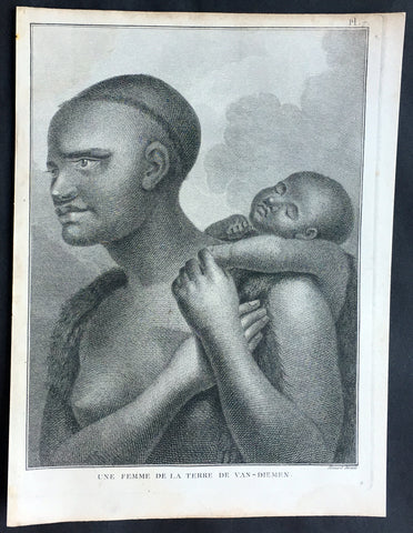
1785 Capt. Cook Antique Print Aboriginal Woman of Bruny Island, Tasmania in 1777
- Title : Une Femme De La Terre De Van-Diemens
- Ref : 50609
- Size: 10in x 8in (255mm x 205mm)
- Date : 1785
- Condition: (A+) Fine Condition
Description:
This fine original copper-plate engraved antique print of an Indigenous Woman & child of Adventure Bay, Bruny Island, Tasmania (Van Diemens Land) encountered by Captain Cook in during his 3rd & last Voyage of Discovery in 1777, was engraved by Robert Benard - after John Webber - and published in the 1785 French edition of Capt. James Cook & Capt. James King A Voyage to the Pacific Ocean. Undertaken, by the Command of his Majesty, for making Discoveries in the Northern Hemisphere. To determine The Position and Extent of the West Side of North America; its Distance from Asia; and the Practicability of a Northen Passage to Europe. Performed under the direction of Captains Cook, Clerke, and Gore, In His Majesty\'s Ships the Resolution and Discovery. In the Years 1776, 1777, 1778, 1779, and 1780. In Three Volumes. Vol. I and II written by James Cook, F.R.S. Vol. III by Captain James King, LL.D. and F.R.S. Paris, 1785.
Adventure Bay
from Cooks Journal......on the 24th (March 1777) at 3 AM we made the Coast of Van Diemen land wrote Cook. Anderson remarked that though now the middle of summer here a spot or two of snow was seen on the highest hills… At ten we passd a point supposd to be the boundary of Stone Bay where Abel Tasman anchord, i.e. Storm Bay. According to David Samwell, surgeons first mate on the Resolution, both Ships anchored in Adventure Bay in Van Diemens Land, this Bay was so called by Captn Furneaux who had anchored here in the Adventure last Voyage.
The next day Cook and Clerke sent parties, one to cut wood and the other grass. Clerke wrote of his party from the Discovery The Guard I had sent with the Parties on shore which consisted of the following Marines, Hamlet Thompson, Geo: Moody, Ben: Harriot, Jos: Pool & Willm Broom, stole some Liquor & made themselves exceedingly drunk, for which they receivd a dozen lashes each in the Morning. The Privates were all from the Plymouth division of marines. Hamlet Thompson was from the 6th Company, George Moody from the 70th, John Herriott the 12th, James Poole the 33rd and William Broom the 36th. According to Thomas Edgar, Master, they made themselves so Beastly Drunk that they were put motionless in the Boat, and when brought on board were oblig\'d to be hoisted into the Ship.
William Bayly, astronomer on the Discovery, wrote In the morning I carried my Tent observatory & Instruments on Shore & set all up, but was not able to get any observations it being cloudy all day, in the evening Capt Cook Sent for me & told me he had Altered his mind relative to his stay, & ordered me to pack all up & carry the whole on board again, as he intend[ed] to sail for New Zealand in a day or two.
John Henry Martin, seaman on the Discovery, described the natives. They have few, or no wants, & seemed perfectly Happy, if one might judge from their behaviour, for they frequently woud burst out, into the most immoderate fits of Laughter & when one Laughed every one followed his example Emediately.
General Definitions:
Paper thickness and quality: - Heavy and stable
Paper color : - off white
Age of map color: -
Colors used: -
General color appearance: -
Paper size: - 10in x 8in (255mm x 205mm)
Plate size: - 9 1/2in x 7 1/4in (240mm x 185mm)
Margins: - Min 1/2in (12mm)
Imperfections:
Margins: - None
Plate area: - None
Verso: - None
Background:
Adventure Bay is the name of both a township and a geographical feature on the eastern side of Bruny Island, Tasmania.
The first European to sight the bay was explorer Abel Tasman, who sought to anchor his vessel Heemskerck there in 1642. Instead, Heemskerck was driven back offshore by a storm, in token of which Tasman named the place Storm Bay. Captain Tobias Furneaux renamed it in March 1773, in honour of his ship HMS Adventure, which he had anchored in the bay for five days after becoming separated from Captain James Cook\'s HMS Resolution during Cook\'s second voyage to the Pacific search of Terra Australis Incognita. Furneaux\'s log made clear the bay was an excellent anchorage for resupplying vessels:....to the SW of the first watering place there is a large lagoon which I believe has plenty of fish in it for one of our Gentlemen caught upwards of 2 dozen trout, and shot a possum which was the only animal we saw. There are a great many gum trees and of a vast thickness and height, one of which measured in circumference 26 feet and the height under the branches was 20 feet.
Others among Furneaux\'s crew spotted evidence of what they believed were small deer but were more likely kangaroos. Furneaux also noted signs of an Aboriginal settlement in the form of several huts or wigwams on shore, with several bags of grass in which they carry their shellfish. - but the branches of which the huts were made were split and torn and there was not the least appearance of any people.
Reliably mapped and offering an abundance of water, fresh water and game, Adventure Bay quickly became a popular anchorage for European explorers. Cooks Resolution watered there in 1777, followed by William Bligh aboard HMS Bounty in 1788 and HMS Providence in 1792. Others who resupplied their vessels in the bay in this period included Bruni d Entrecasteaux aboard Recherché in 1792 and 1793, and Nicolas Baudin in the corvette Géographe in 1802. Matthew Flinders also tried to enter the bay with Norfolk in 1798.
John Hawkesworth 1715 – 1773 English writer and book editor.
He is said to have been clerk to an attorney, and was certainly self-educated. In 1744, he succeeded Samuel Johnson as compiler of the parliamentary debates for the Gentleman\\\'s Magazine, and from 1746 to 1749 he contributed poems signed Greville, or H Greville, to that journal. In company with Johnson and others he started a periodical called The Adventurer, which ran to 140 issues, of which 70 were from the pen of Hawkesworth himself.
On account of what was regarded as his powerful defense of morality and religion, Hawkesworth was rewarded by the archbishop of Canterbury with the degree of LL.D, In 1754–1755 he published an edition (12 vols) of Swifts works, with a life prefixed which Johnson praised in his Lives of the Poets. A larger edition (27 vols) appeared in 1766–1779. He adapted Dryden\\\'s Amphitryon for the Drury Lane stage in 1756, and Southernes Oronooko in 1759. He wrote the libretto of an oratorio Zimri in 1760, and the next year Edgar and Emmeline: a Fairy Tale was produced at Drury Lane. His Almoran and Hamet (1761) was first drafted as a play[citation needed], and a tragedy based on it by S J Pratt, The Fair Circassian (1781), met with some success.
He was commissioned by the Admiralty to edit Captain James Cooks papers relative to his first voyage. For this work, An Account of the Voyages undertaken ... for making discoveries in the Southern Hemisphere and performed by Commodore Byrone John Byron, Captain Wallis, Captain Carteret and Captain Cook (from 1702 to 1771) drawn up from the Journals ... (3 vols, 1773) Hawkesworth is said to have received from the publishers the sum of £6000. His descriptions of the manners and customs of the South Seas were, however, regarded by many critics as inexact and hurtful to the interests of morality, and the severity of their strictures is said to have hastened his death. He was buried in the parish church at Bromley, Kent, where he and his wife had kept a school.
Hawkesworth was a close imitator of Johnson both in style and thought, and was at one time on very friendly terms with him. It is said that he presumed on his success, and lost Johnsons friendship as early as 1756.
Captain James King FRS 1750 – 1784 was an officer of the Royal Navy. He served under James Cook on his last voyage around the world, specialising in taking important astronomical readings using a sextant. After Cook died he helped lead the ships on the remainder of their course, also completing Cook\\\'s account of the voyage. He continued his career in the Navy, reaching the rank of post-captain, commanding several ships and serving in the American War of Independence.
King joined HMS Resolution as second lieutenant, sharing the duties of astronomer with Cook, taking astronomical observations on board by sextant and with Larcum Kendals timekeeper K1, to establish the Resolutions position at sea and on shore by sextant or by astronomical quadrant to establish the geographical position of salient points during the course of Cooks surveys. Thus King\\\'s geographical positions were an important contribution to the accuracy of the various surveys carried out during the voyage and his use of the early chronometers helped prove their use at sea for calculation of Longitude. .
Following the death of Cook, King remained in the Resolution but on the death of Charles Clerke, Cooks successor, King was appointed to command HMS Discovery, the Resolution\\\'s consort, remaining in her for the rest of the voyage. After his return to England King was very much involved in the publication of the official account of Cooks third voyage, writing the third volume at Woodstock, near Oxford, where his brother Thomas was rector of St Mary Magdalene. But shortly after his return King was promoted Post-captain and appointed commander of HMS Crocodile in the English Channel.
John Webber RA 1751 – 1793 was an English artist who accompanied Captain Cook on his third Pacific expedition. He is best known for his images of Australasia, Hawaii and Alaska.
Webber was born in London, educated in Bern and studied painting at Paris.His father was Abraham Wäber, a Swiss sculptor who had moved to London, and changed his name to Webber before marrying a Mrs Mary Quant in 1744.
Webber served as official artist on James Cook\'s third voyage of discovery around the Pacific (1776–80) aboard HMS Resolution. At Adventure Bay in January 1777 he did drawings of A Man of Van Diemens Land and A Woman of Van Diemens Land. He also did many drawings of scenes in New Zealand and the South Sea islands. On this voyage, during which Cook lost his life in a fight in Hawaii, Webber became the first European artist to make contact with Hawaii, then called the Sandwich Islands. He made numerous watercolor landscapes of the islands of Kauai and Hawaii, and also portrayed many of the Hawaiian people.
In April 1778, Captain Cooks ships Resolution and Discovery anchored at Ship Cove, now known as Nootka Sound, Vancouver Island, Canada to refit. The crew took observations and recorded encounters with the local people. Webber made watercolour landscapes including Resolution and Discovery in Ship Cove, 1778. His drawings and paintings were engraved for British Admiraltys account of the expedition, which was published in 1784.
Back in England in 1780 Webber exhibited around 50 works at Royal Academy exhibitions between 1784 and 1792, and was elected an associate of the Royal Academy in 1785 and R.A. in 1791. Most of his work were landscapes. Sometimes figures were included as in A Party from H.M.S. Resolution shooting sea horses\", which was shown at the academy in 1784, and his The Death of Captain Cook became well known through an engraving of it. Another version of this picture is in the William Dixson gallery at Sydney
Robert Bénard 1734 – 1777 was an 18th-century French engraver.
Specialized in the technique of engraving, Robert Ménard is mainly famous for having supplied a significant amount of plates (at least 1,800) to the Encyclopédie by Diderot & d\'Alembert from 1751.
Later, publisher Charles-Joseph Panckoucke reused many of his productions to illustrate the works of his catalog.
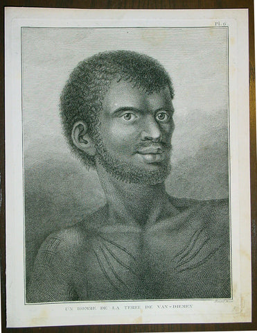
1785 Capt. Cook Antique Print Aboriginal Man of Bruny Island, Tasmania in 1777
- Title : Un Homme De La Terre De Van-Diemens
- Ref : 43195
- Size: 10in x 8in (255mm x 205mm)
- Date : 1785
- Condition: (A+) Fine Condition
Description:
This fine original copper-plate engraved antique print of an Indigenous Man of Adventure Bay, Bruny Island, Tasmania (Van Diemens Land) encountered by Captain Cook in during his 3rd & last Voyage of Discovery in 1777, was engraved by Robert Benard - after John Webber - and published in the 1785 French edition of Capt. James Cook & Capt. James King A Voyage to the Pacific Ocean. Undertaken, by the Command of his Majesty, for making Discoveries in the Northern Hemisphere. To determine The Position and Extent of the West Side of North America; its Distance from Asia; and the Practicability of a Northen Passage to Europe. Performed under the direction of Captains Cook, Clerke, and Gore, In His Majesty\'s Ships the Resolution and Discovery. In the Years 1776, 1777, 1778, 1779, and 1780. In Three Volumes. Vol. I and II written by James Cook, F.R.S. Vol. III by Captain James King, LL.D. and F.R.S. Paris, 1785.
Adventure Bay
from Cooks Journal......on the 24th (March 1777) at 3 AM we made the Coast of Van Diemen land wrote Cook. Anderson remarked that though now the middle of summer here a spot or two of snow was seen on the highest hills… At ten we passd a point supposd to be the boundary of Stone Bay where Abel Tasman anchord, i.e. Storm Bay. According to David Samwell, surgeons first mate on the Resolution, both Ships anchored in Adventure Bay in Van Diemens Land, this Bay was so called by Captn Furneaux who had anchored here in the Adventure last Voyage.
The next day Cook and Clerke sent parties, one to cut wood and the other grass. Clerke wrote of his party from the Discovery The Guard I had sent with the Parties on shore which consisted of the following Marines, Hamlet Thompson, Geo: Moody, Ben: Harriot, Jos: Pool & Willm Broom, stole some Liquor & made themselves exceedingly drunk, for which they receivd a dozen lashes each in the Morning. The Privates were all from the Plymouth division of marines. Hamlet Thompson was from the 6th Company, George Moody from the 70th, John Herriott the 12th, James Poole the 33rd and William Broom the 36th. According to Thomas Edgar, Master, they made themselves so Beastly Drunk that they were put motionless in the Boat, and when brought on board were oblig\'d to be hoisted into the Ship.
William Bayly, astronomer on the Discovery, wrote In the morning I carried my Tent observatory & Instruments on Shore & set all up, but was not able to get any observations it being cloudy all day, in the evening Capt Cook Sent for me & told me he had Altered his mind relative to his stay, & ordered me to pack all up & carry the whole on board again, as he intend[ed] to sail for New Zealand in a day or two.
John Henry Martin, seaman on the Discovery, described the natives. They have few, or no wants, & seemed perfectly Happy, if one might judge from their behaviour, for they frequently woud burst out, into the most immoderate fits of Laughter & when one Laughed every one followed his example Emediately.
General Definitions:
Paper thickness and quality: - Heavy and stable
Paper color : - off white
Age of map color: -
Colors used: -
General color appearance: -
Paper size: - 10in x 8in (255mm x 205mm)
Plate size: - 9 1/2in x 7 1/4in (240mm x 185mm)
Margins: - Min 1/2in (12mm)
Imperfections:
Margins: - None
Plate area: - None
Verso: - None
Background:
Adventure Bay is the name of both a township and a geographical feature on the eastern side of Bruny Island, Tasmania.
The first European to sight the bay was explorer Abel Tasman, who sought to anchor his vessel Heemskerck there in 1642. Instead, Heemskerck was driven back offshore by a storm, in token of which Tasman named the place Storm Bay. Captain Tobias Furneaux renamed it in March 1773, in honour of his ship HMS Adventure, which he had anchored in the bay for five days after becoming separated from Captain James Cook\'s HMS Resolution during Cook\'s second voyage to the Pacific search of Terra Australis Incognita. Furneaux\'s log made clear the bay was an excellent anchorage for resupplying vessels:....to the SW of the first watering place there is a large lagoon which I believe has plenty of fish in it for one of our Gentlemen caught upwards of 2 dozen trout, and shot a possum which was the only animal we saw. There are a great many gum trees and of a vast thickness and height, one of which measured in circumference 26 feet and the height under the branches was 20 feet.
Others among Furneaux\'s crew spotted evidence of what they believed were small deer but were more likely kangaroos. Furneaux also noted signs of an Aboriginal settlement in the form of several huts or wigwams on shore, with several bags of grass in which they carry their shellfish. - but the branches of which the huts were made were split and torn and there was not the least appearance of any people.
Reliably mapped and offering an abundance of water, fresh water and game, Adventure Bay quickly became a popular anchorage for European explorers. Cooks Resolution watered there in 1777, followed by William Bligh aboard HMS Bounty in 1788 and HMS Providence in 1792. Others who resupplied their vessels in the bay in this period included Bruni d Entrecasteaux aboard Recherché in 1792 and 1793, and Nicolas Baudin in the corvette Géographe in 1802. Matthew Flinders also tried to enter the bay with Norfolk in 1798.
John Hawkesworth 1715 – 1773 English writer and book editor.
He is said to have been clerk to an attorney, and was certainly self-educated. In 1744, he succeeded Samuel Johnson as compiler of the parliamentary debates for the Gentleman\\\'s Magazine, and from 1746 to 1749 he contributed poems signed Greville, or H Greville, to that journal. In company with Johnson and others he started a periodical called The Adventurer, which ran to 140 issues, of which 70 were from the pen of Hawkesworth himself.
On account of what was regarded as his powerful defense of morality and religion, Hawkesworth was rewarded by the archbishop of Canterbury with the degree of LL.D, In 1754–1755 he published an edition (12 vols) of Swifts works, with a life prefixed which Johnson praised in his Lives of the Poets. A larger edition (27 vols) appeared in 1766–1779. He adapted Dryden\\\'s Amphitryon for the Drury Lane stage in 1756, and Southernes Oronooko in 1759. He wrote the libretto of an oratorio Zimri in 1760, and the next year Edgar and Emmeline: a Fairy Tale was produced at Drury Lane. His Almoran and Hamet (1761) was first drafted as a play[citation needed], and a tragedy based on it by S J Pratt, The Fair Circassian (1781), met with some success.
He was commissioned by the Admiralty to edit Captain James Cooks papers relative to his first voyage. For this work, An Account of the Voyages undertaken ... for making discoveries in the Southern Hemisphere and performed by Commodore Byrone John Byron, Captain Wallis, Captain Carteret and Captain Cook (from 1702 to 1771) drawn up from the Journals ... (3 vols, 1773) Hawkesworth is said to have received from the publishers the sum of £6000. His descriptions of the manners and customs of the South Seas were, however, regarded by many critics as inexact and hurtful to the interests of morality, and the severity of their strictures is said to have hastened his death. He was buried in the parish church at Bromley, Kent, where he and his wife had kept a school.
Hawkesworth was a close imitator of Johnson both in style and thought, and was at one time on very friendly terms with him. It is said that he presumed on his success, and lost Johnsons friendship as early as 1756.
Captain James King FRS 1750 – 1784 was an officer of the Royal Navy. He served under James Cook on his last voyage around the world, specialising in taking important astronomical readings using a sextant. After Cook died he helped lead the ships on the remainder of their course, also completing Cook\\\'s account of the voyage. He continued his career in the Navy, reaching the rank of post-captain, commanding several ships and serving in the American War of Independence.
King joined HMS Resolution as second lieutenant, sharing the duties of astronomer with Cook, taking astronomical observations on board by sextant and with Larcum Kendals timekeeper K1, to establish the Resolutions position at sea and on shore by sextant or by astronomical quadrant to establish the geographical position of salient points during the course of Cooks surveys. Thus King\\\'s geographical positions were an important contribution to the accuracy of the various surveys carried out during the voyage and his use of the early chronometers helped prove their use at sea for calculation of Longitude. .
Following the death of Cook, King remained in the Resolution but on the death of Charles Clerke, Cooks successor, King was appointed to command HMS Discovery, the Resolution\\\'s consort, remaining in her for the rest of the voyage. After his return to England King was very much involved in the publication of the official account of Cooks third voyage, writing the third volume at Woodstock, near Oxford, where his brother Thomas was rector of St Mary Magdalene. But shortly after his return King was promoted Post-captain and appointed commander of HMS Crocodile in the English Channel.
John Webber RA 1751 – 1793 was an English artist who accompanied Captain Cook on his third Pacific expedition. He is best known for his images of Australasia, Hawaii and Alaska.
Webber was born in London, educated in Bern and studied painting at Paris.His father was Abraham Wäber, a Swiss sculptor who had moved to London, and changed his name to Webber before marrying a Mrs Mary Quant in 1744.
Webber served as official artist on James Cook\'s third voyage of discovery around the Pacific (1776–80) aboard HMS Resolution. At Adventure Bay in January 1777 he did drawings of A Man of Van Diemens Land and A Woman of Van Diemens Land. He also did many drawings of scenes in New Zealand and the South Sea islands. On this voyage, during which Cook lost his life in a fight in Hawaii, Webber became the first European artist to make contact with Hawaii, then called the Sandwich Islands. He made numerous watercolor landscapes of the islands of Kauai and Hawaii, and also portrayed many of the Hawaiian people.
In April 1778, Captain Cooks ships Resolution and Discovery anchored at Ship Cove, now known as Nootka Sound, Vancouver Island, Canada to refit. The crew took observations and recorded encounters with the local people. Webber made watercolour landscapes including Resolution and Discovery in Ship Cove, 1778. His drawings and paintings were engraved for British Admiraltys account of the expedition, which was published in 1784.
Back in England in 1780 Webber exhibited around 50 works at Royal Academy exhibitions between 1784 and 1792, and was elected an associate of the Royal Academy in 1785 and R.A. in 1791. Most of his work were landscapes. Sometimes figures were included as in A Party from H.M.S. Resolution shooting sea horses\", which was shown at the academy in 1784, and his The Death of Captain Cook became well known through an engraving of it. Another version of this picture is in the William Dixson gallery at Sydney
Robert Bénard 1734 – 1777 was an 18th-century French engraver.
Specialized in the technique of engraving, Robert Ménard is mainly famous for having supplied a significant amount of plates (at least 1,800) to the Encyclopédie by Diderot & d\'Alembert from 1751.
Later, publisher Charles-Joseph Panckoucke reused many of his productions to illustrate the works of his catalog.
1755 Prevost Antique Print Plants found by William Dampier in Australia in 1688
- Title: 1.2.3.4. Plantee de la Nle. Hollande 5.6.7.8. Plantes que Dampierre trouva au Brezil
- Date: 1755
- Size: 14in x 10in (355mm x 255mm)
- Ref: 26047
- Condition : (A+) Fine Condition
Description:
This fine, original copper-plate engraved antique print of plants and flowers first discovered in New Holland (Australia) in 1688 & Brazil by William Dampier first published in his 1697 edition of William Dampiers Voyages and Travels. by Jakob van Schley in 1755 - after Dampier - was published in Antoine François Prevosts 15 volumes of Histoire Generale des Voyages written by Prevost & other authors between 1746-1790.
In 1688 William Dampier (1652-1715) was the first Englishman to land in Australia. He arrived on the west coast in privateer ship Cygnet which was grounded for repairs at Shark Bay for two months. As he had done in Brazil, and would also do in New Guinea, Dampier sketched flora, fauna and native people during this time. After his return to England these simple sketches were published in 1697 in Dampier’s book A New Voyage Round the World. Usually nature discoveries were published with contemporary colour - each hand-coloured in accordance with the drawing from the artist on the voyage, but paintboxes were probably not priority for pirates, and his botanical engravings remained uncoloured when published.
During more than twelve years, in just as many ships and various voyages, Dampier circumnavigated the world three times – and became the first to do so. His stories of his travels were well-received by the public and he revised and published to accommodate their popularity. Travel was something that most people could only be read about, and stories of discoveries were popular everywhere. From 1705 Dampier’s “Voyages and Discoveries” were even published in France.
Dampier arrived on the west coast of Australia in 1688 Cygnet was grounded for repairs for two months at Shark Bay. As he had done in Brazil and would do in New Guinea, William Dampier sketched local flowers, plants and grasses, birds and animals, and natives. He was not impressed with the terrain. After his return to England, copperplate engravings from these simple sketches were published in 1697 for Dampier’s A New Voyage Round the World. Usually nature discoveries were published with contemporary colour - each hand-coloured in accordance with the drawing from the artist on the voyage, but Dampier probably didn’t have a paintbox with him, so his botanical engravings remained uncoloured when published.
General Definitions:
Paper thickness and quality: - Heavy and stable
Paper color : - off white
Age of map color: - Early
Colors used: - Yellow, green, pink
General color appearance: - Authentic
Paper size: - 15in x 10in (385mm x 255mm)
Plate size: - 14in x 8 1/2in (355mm x 220mm)
Margins: - Min 1in (25mm)
Imperfections:
Margins: - None
Plate area: - None
Verso: - None
Background:
One of Antoine Francois Prevosts monumental undertakings was his history of exploration & discovery in 15 volumes titledHistoire Générale des Voyages written between 1746-1759 and was extended to 20 volumes after his death by various authors.
The 20 volumes cover the early explorations & discoveries on 3 continents: Africa (v. 1-5), Asia (v. 5-11), and America (v. 12-15) with material on the finding of the French, English, Dutch, and Portugese.
A number of notable cartographers and engravers contributed to the copper plate maps and views to the 20 volumes including Nicolas Bellin, Jan Schley, Chedel, Franc Aveline, Fessard, and many others.
The African volumes cover primarily coastal countries of West, Southern, and Eastern Africa, plus the Congo, Madagascar, Arabia and the Persian Gulf areas.
The Asian volumes cover China, Korea, Tibet, Japan, Philippines, and countries bordering the Indian Ocean.
Volume 11 includes Australia and Antarctica.
Volumes 12-15 cover voyages and discoveries in America, including the East Indies, South, Central and North America.
Volumes 16-20 include supplement volumes & tables along with continuation of voyages and discoveries in Russia, Northern Europe, America, Asia & Australia.
Jakob van der Schley aka Jakob van Schley (1715 - 1779) was a Dutch draughtsman and engraver. He studied under Bernard Picart (1673-1733) whose style he subsequently copied. His main interests were engraving portraits and producing illustrations for \\\"La Vie de Marianne\\\" by Pierre Carlet de Chamblain de Marivaux (1688-1763) published in The Hague between 1735 and 1747.
He also engraved the frontispieces for a 15-volume edition of the complete works of Pierre de Brantôme (1540-1614), \\\"Oeuvres du seigneur de Brantôme\\\", published in The Hague in 1740.
He is also responsible for most of the plates in the Hague edition of Prévosts Histoire générale des voyages. (Ref: Tooley; M&B)