Nicolas Sanson (1600-67)
Profile :
Nicolas Sanson was born in Abbeville where as a young man he studied history, particularly the ancient world, and it is said that he turned to cartography only as a means of illustrating his historical work. For this purpose he prepared a number of beautifully drawn maps, one of which came to the attention of Louis XIII. In due course the King appointed him “ Geographe Ordinaire du Roi”.
In preparation of his major atlas, “Cartes Generales de Toutes les Parties du Monde”, Sanson employed a number of engravers, one of whom, M. Tavernier engraved important maps showing the post roads, rivers and waterway system of France (1632-34) and a map of the British Isles (1640). In all Sanson produced about 300 maps of which two of North America were particularly influential: “Amerique Septentrionale” (1650) and Le Canada ou Nouvelle France (1656).
After Sansons death the business was carried on by his two surviving sons and grandson, in partnership with A.H. Jaillot. It is generally accepted that the great age of French cartography originated with the work of Nicolas Sanson but credit must go also to A. H. Jaillot (1632 – 1712) and Pierre Duval for re-engraving his maps, many still unprinted after his death, and re-publishing them in face of strong competition from the Dutch, who continued to dominate the market until the end of the 17th century.
Nicolas Sanson (9)
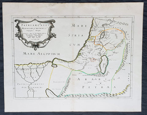
1640 Nicolas Sanson Antique Map of The Holy Land, Egypt, Saudi - Knights Templar
- Title : Patriachatus Hierosolymitani....Aput M Tavernier....1640
- Size: 22 1/2in x 18in (570mm x 460mm)
- Condition: (A+) Fine Condition
- Date : 1640
- Ref #: 40692
Description:
This fine original hand coloured copper-plate engraved antique map of the Holy Land, Egypt, part of Saudi Arabia and the connection to the Nights Templar (Latin: Militaris Templi Hierosolymitani) in the middle ages was engraved by Michael Tavernier in 1640 - dated in the cartouche - and was published by Nicolas Sanson in the 1653 edition of Geographia sacra, sive notitia antiqua dioecesium omnium partriarchalium, metropoliticarum, et episcopalium veteris ecclesiae. notae et animadversions Lucae Holstenii.
This is a wonderful map with original outline hand colour on strong sturdy clean paper and a heavy impression.
General Definitions:
Paper thickness and quality: - Heavy and stable
Paper color : - off white
Age of map color: - Original
Colors used: - Yellow, Green, pink
General color appearance: - Authentic
Paper size: - 22 1/2in x 18in (570mm x 460mm)
Plate size: - 20in x 14in (510mm x 370mm)
Margins: - Min 1in (25mm)
Imperfections:
Margins: - None
Plate area: - None
Verso: - None
Background:
The Templars became a favoured charity throughout Christendom and grew rapidly in membership and power. They were prominent in Christian finance. Templar knights, in their distinctive white mantles with a red cross, were among the most skilled fighting units of the Crusades. Non-combatant members of the order, who formed as much as 90% of the orders members, managed a large economic infrastructure throughout Christendom, developing innovative financial techniques that were an early form of banking, building its own network of nearly 1,000 commanderies and fortifications across Europe and the Holy Land, and arguably forming the worlds first multinational corporation.
The Templars were closely tied to the Crusades; when the Holy Land was lost, support for the order faded. Rumours about the Templars secret initiation ceremony created distrust, and King Philip IV of France – deeply in debt to the order – took advantage of this distrust to destroy them and erase his debt. In 1307, he had many of the orders members in France arrested, tortured into giving false confessions, and burned at the stake. Pope Clement V disbanded the order in 1312 under pressure from King Philip. The abrupt reduction in power of a significant group in European society gave rise to speculation, legend, and legacy through the ages.
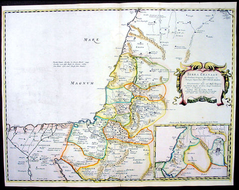
1650 Nicolas Sanson Antique Map of The Holy Lands, Canaan
- Title : Terra Chanaan..
- Ref #: 40679
- Size: 22 1/2in x 17 1/2in (570mm x 445mm)
- Date : 1650
- Condition: (A) Very Good Condition
Description:
This beautifully hand coloured original antique map of the Holy Land and the Land of Canaan was engraved by Jon Somer and was published by Nicholas Sanson in the 1650 edition ofCartes Generales de Toutes les Parties du Monde.
Canaan is an ancient term for a region encompassing modern-day Israel, Lebanon, the Palestinian territories and adjoining coastal lands, including parts of Jordan, Syria and northeastern Egypt. In the Hebrew Bible, the "Land of Canaan" extends from Lebanon southward across Gaza to the "Brook of Egypt" and eastward to the Jordan River Valley. In far ancient times, the southern area included various ethnic groups. The Amarna Letters found in Ancient Egypt mention Canaan (Akkadian: Kinaḫḫu) in connection with Gaza and other cities along the Phoenician coast and into Upper Galilee. Many earlier Egyptian sources also mention numerous military campaigns conducted in Ka-na-na, just inside Asia. (Ref:Tooley; Koeman)
General Description:
Paper thickness and quality: - Heavy and stable
Paper color: - White
Age of map color: - Original & later color
Colors used: - Yellow, green, pink
General color appearance: - Authentic
Paper size: - 22 1/2in x 17 1/2in (570mm x 445mm)
Plate size: - 22in x 16 1/2in (560mm x 420mm)
Margins: - Min 1/4in (6mm)
Imperfections:
Margins: - None
Plate area: - Worm holes repair to top & bottom centrefold
Verso: - None
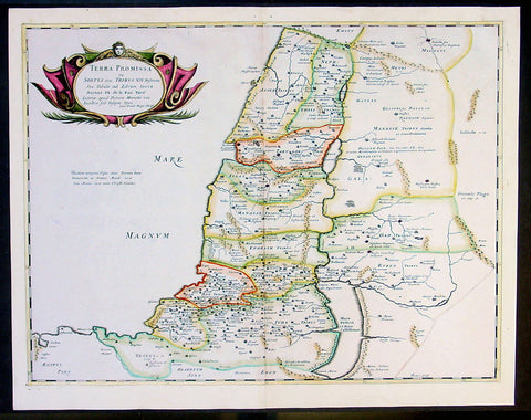
1650 Sanson Large Antique Map of the Holy Land - 12 Tribes of Israel
- Title : Terra Promissa in Sortes seu Tribus XII...Auctore de la Rue
- Ref #: 40680
- Size: 22 1/2in x 17 1/2in (570mm x 445mm)
- Date : 1650
- Condition: (A) Very Good Condition
Description:
This beautifully hand coloured originalantique map of the Promised Land divided into the 12 tribes by Philippe De la Rue was engraved by John Somer and was published by Nicholas Sanson in the 1650 edition ofCartes Generales de Toutes les Parties du Monde. (Ref:Tooley; Koeman)
General Description:
Paper thickness and quality: - Heavy and stable
Paper color: - White
Age of map color: - Original color
Colors used: - Yellow, green, pink
General color appearance: - Authentic
Paper size: - 22 1/2in x 17 1/2in (570mm x 445mm)
Plate size: - 21in x 16in (535mm x 410m)
Margins: - Min 1/2in (12mm)
Imperfections:
Margins: - None
Plate area: - Small worm holes repaired along top centerfold
Verso: - None
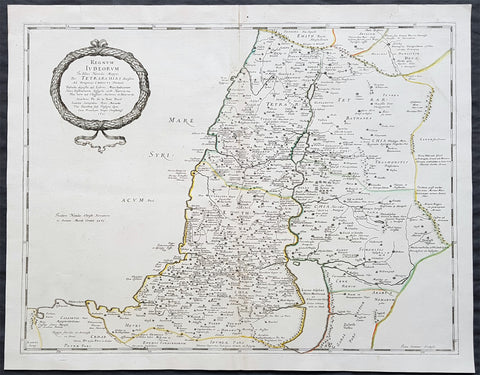
1651 Nicolas Sanson Large Antique Map of Holy Land Judea during Herodian Dynasty
- Title : Regnum Judeorum In Filios Herodis Magni Per Tetarchias...Petri Mariette...1651
- Ref #: 43168
- Size: 25in x 21 1/4in (635mm x 540mm)
- Date : 1651
- Condition: (A+) Fine Condition
Description:
This fine original hand coloured copper-plate engraved antique map of the Holy Land, the land of Judea during the Herodian Dynasty, by Nicolas Sanson, was engraved by Jean Sommer in 1651 - dated in the cartouche - and was published by Pierre Mariette in the 1653 edition of Geographia sacra, sive notitia antiqua dioecesium omnium partriarchalium, metropoliticarum, et episcopalium veteris ecclesiae. notae et animadversions Lucae Holstenii.
This is a wonderful map with original outline hand colour on strong sturdy clean paper and a heavy impression.
General Definitions:
Paper thickness and quality: - Heavy and stable
Paper color : - off white
Age of map color: - Original
Colors used: - Yellow, green, blue, pink
General color appearance: - Authentic
Paper size: - 25in x 21 1/4in (635mm x 540mm)
Plate size: - 23in x 19 1/2in (590mm x 500mm)
Margins: - Min 1/2in (12mm)
Imperfections:
Margins: - None
Plate area: - None
Verso: - None
Background:
The Herodian dynasty was a royal dynasty of Idumaean (Edomite) descent, ruling the Herodian Kingdom and later the Herodian Tetrarchy, as vassals of the Roman Empire. The Herodian dynasty began with Herod the Great, who assumed the throne of Judea, with Roman support, bringing down the century long Hasmonean Kingdom. His kingdom lasted until his death in 4 BCE, when it was divided between his sons as a Tetrarchy, which lasted for about 10 years. Most of those tetrarchies, including Judea proper, were incorporated into Judaea Province from 6 CE, though limited Herodian de facto kingship continued until Agrippa I\'s death in 44 CE and nominal title of kingship continued until 92 CE, when the last Herodian monarch, Agrippa II, died and Rome assumed full power over his de jure domain.
Judea or Judæa is the ancient Hebrew and Israelite biblical, the exonymic Roman/English, and the modern-day name of the mountainous southern part of the region of Palestine. The name originates from the Hebrew name Yehudah, a son of the Jewish patriarch Jacob/Israel, and Yehudahs progeny forming the biblical Israelite tribe of Judah (Yehudah) and later the associated Kingdom of Judah, which the 1906 Jewish Encyclopedia dates from 934 until 586 BCE. The name of the region continued to be incorporated through the Babylonian conquest, Persian, Hellenistic, and Roman periods as Yehud, Yehud Medinata, Hasmonean Judea, and consequently Herodian Judea and Roman Judea, respectively.
The Holy Land is an area roughly located between the Jordan River and the Mediterranean Sea that also includes the Eastern Bank of the Jordan River. Traditionally, it is synonymous with both the biblical Land of Israel and historical Palestine. The term usually refers to a territory roughly corresponding to the modern State of Israel, the Palestinian territories, western Jordan, and parts of southern Lebanon and southwestern Syria. It is considered holy by Jews, Christians, and Muslims.
Part of the significance of the land stems from the religious significance of Jerusalem, the holiest city to Judaism, the historical region of Jesus\' ministry, and the site of the Isra and Miraj event in Islam.
The holiness of the land to Christianity was part of the motivation for the Crusades, as European Christians sought to win back the Holy Land from the Muslims, who had conquered it from the Christian Byzantine Empire.
Many sites in the Holy Land have long been pilgrimage destinations for adherents of the Abrahamic religions, including Jews, Christians, Muslims, and Baháís. Pilgrims visit the Holy Land to touch and see physical manifestations of their faith, confirm their beliefs in the holy context with collective excitation, and connect personally to the Holy Land.
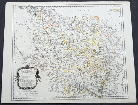
1661 Nicolas Sanson Large Antique Map of the Lorraine Region of France
- Title : La Lorraine et les etats passent sous le Nom de Lorraine.....Sr Sanson...1661
- Size: 23in x 18in (585mm x 475mm)
- Condition: (A) Very Good Condition
- Date : 1661
- Ref #: 40665
Description:
This original copper-plate engraved antique map of the Lorraine region of France was engraved by Louis Cordier in 1661 - dated - and was published by Nicholas Sanson in his atlas Cartes Generales de Toutes les Parties du Monde.
General Definitions:
Paper thickness and quality: - Heavy and stable
Paper color : - off white
Age of map color: - Original
Colors used: - Yellow, green, pink, orange
General color appearance: - Authentic
Paper size: - 23in x 18in (585mm x 475mm)
Plate size: - 20in x 17in (510mm x 415mm)
Margins: - Min 1/2in (12mm)
Imperfections:
Margins: - None
Plate area: - None
Verso: - Small restoration along centerfold
Background:
Lorraine is a cultural and historical region in north-eastern France, now located in the administrative region of Grand Est. Lorraines name stems from the medieval kingdom of Lotharingia, which in turn was named for either Emperor Lothair I or King Lothair II. It later was ruled as the Duchy of Lorraine before the Kingdom of France annexed it in 1766.
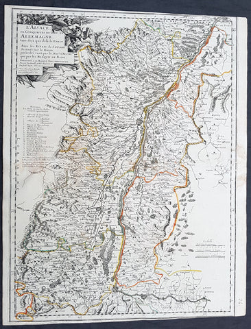
1666 Nicolas Sanson Large Antique Map of the Alsace Region of France & Germany
- Title : L Alsace ou Conquestes du Roy en Allemagne...G S Sanson...1666
- Size: 23in x 18in (585mm x 475mm)
- Condition: (A) Very Good Condition
- Date : 1666
- Ref #: 40631
Description:
This original copper-plate engraved antique map of the Alsace region of France & Germany - centering on the Rhine River - was engraved by Pierre Mariette in 1666 - dated - and was published by Nicholas Sanson in his atlas Cartes Generales de Toutes les Parties du Monde.
General Definitions:
Paper thickness and quality: - Heavy and stable
Paper color : - off white
Age of map color: - Original
Colors used: - Yellow, green, pink, orange
General color appearance: - Authentic
Paper size: - 23in x 18in (585mm x 475mm)
Plate size: - 20in x 17in (510mm x 415mm)
Margins: - Min 1/2in (12mm)
Imperfections:
Margins: - T&B margins cropped to borders
Plate area: - None
Verso: - Small restoration along centerfold
Background:
Alsace is a cultural and historical region in eastern France, on the west bank of the upper Rhine next to Germany and Switzerland.
In 1469, following the Treaty of St. Omer [fr], Upper Alsace was sold by Archduke Sigismund of Austria to Charles the Bold, Duke of Burgundy. Although Charles was the nominal landlord, taxes were paid to Frederick III, Holy Roman Emperor. The latter was able to use this tax and a dynastic marriage to his advantage to gain back full control of Upper Alsace (apart from the free towns, but including Belfort) in 1477 when it became part of the demesne of the Habsburg family, who were also rulers of the empire. The town of Mulhouse joined the Swiss Confederation in 1515, where it was to remain until 1798.
By the time of the Protestant Reformation in the 16th century, Strasbourg was a prosperous community, and its inhabitants accepted Protestantism in 1523. Martin Bucer was a prominent Protestant reformer in the region. His efforts were countered by the Roman Catholic Habsburgs who tried to eradicate heresy in Upper Alsace. As a result, Alsace was transformed into a mosaic of Catholic and Protestant territories. On the other hand, Mömpelgard (Montbéliard) to the southwest of Alsace, belonging to the Counts of Württemberg since 1397, remained a Protestant enclave in France until 1793.
This situation prevailed until 1639, when most of Alsace was conquered by France to keep it out of the hands of the Spanish Habsburgs, who by secret treaty in 1617 had gained a clear road to their valuable and rebellious possessions in the Spanish Netherlands, the Spanish Road. Beset by enemies and seeking to gain a free hand in Hungary, the Habsburgs sold their Sundgau territory (mostly in Upper Alsace) to France in 1646, which had occupied it, for the sum of 1.2 million Thalers. When hostilities were concluded in 1648 with the Treaty of Westphalia, most of Alsace was recognized as part of France, although some towns remained independent. The treaty stipulations regarding Alsace were complex. Although the French king gained sovereignty, existing rights and customs of the inhabitants were largely preserved. France continued to maintain its customs border along the Vosges mountains where it had been, leaving Alsace more economically oriented to neighbouring German-speaking lands. The German language remained in use in local administration, in schools, and at the (Lutheran) University of Strasbourg, which continued to draw students from other German-speaking lands. The 1685 Edict of Fontainebleau, by which the French king ordered the suppression of French Protestantism, was not applied in Alsace. France did endeavour to promote Catholicism. Strasbourg Cathedral, for example, which had been Lutheran from 1524 to 1681, was returned to the Catholic Church. However, compared to the rest of France, Alsace enjoyed a climate of religious tolerance.
France consolidated its hold with the 1679 Treaties of Nijmegen, which brought most remaining towns under its control. France seized Strasbourg in 1681 in an unprovoked action. These territorial changes were recognised in the 1697 Treaty of Ryswick that ended the War of the Grand Alliance.
The year 1789 brought the French Revolution and with it the first division of Alsace into the départements of Haut- and Bas-Rhin. Alsatians played an active role in the French Revolution. On 21 July 1789, after receiving news of the Storming of the Bastille in Paris, a crowd of people stormed the Strasbourg city hall, forcing the city administrators to flee and putting symbolically an end to the feudal system in Alsace. In 1792, Rouget de Lisle composed in Strasbourg the Revolutionary marching song La Marseillaise (as Marching song for the Army of the Rhine), which later became the anthem of France. La Marseillaise was played for the first time in April of that year in front of the mayor of Strasbourg Philippe-Frédéric de Dietrich. Some of the most famous generals of the French Revolution also came from Alsace, notably Kellermann, the victor of Valmy, Kléber, who led the armies of the French Republic in Vendée and Westermann, who also fought in the Vendée.
At the same time, some Alsatians were in opposition to the Jacobins and sympathetic to the restoration of the monarchy pursued by the invading forces of Austria and Prussia who sought to crush the nascent revolutionary republic. Many of the residents of the Sundgau made pilgrimages to places like Mariastein Abbey, near Basel, in Switzerland, for baptisms and weddings. When the French Revolutionary Army of the Rhine was victorious, tens of thousands fled east before it. When they were later permitted to return (in some cases not until 1799), it was often to find that their lands and homes had been confiscated. These conditions led to emigration by hundreds of families to newly vacant lands in the Russian Empire in 1803–4 and again in 1808. A poignant retelling of this event based on what Goethe had personally witnessed can be found in his long poem Hermann and Dorothea.
In response to the hundred day restoration of Napoleon I of France in 1815, Alsace along with other frontier provinces of France was occupied by foreign forces from 1815 to 1818, including over 280,000 soldiers and 90,000 horses in Bas-Rhin alone. This had grave effects on trade and the economy of the region since former overland trade routes were switched to newly opened Mediterranean and Atlantic seaports.
The population grew rapidly, from 800,000 in 1814 to 914,000 in 1830 and 1,067,000 in 1846. The combination of economic and demographic factors led to hunger, housing shortages and a lack of work for young people. Thus, it is not surprising that people left Alsace, not only for Paris – where the Alsatian community grew in numbers, with famous members such as Baron Haussmann – but also for more distant places like Russia and the Austrian Empire, to take advantage of the new opportunities offered there: Austria had conquered lands in Eastern Europe from the Ottoman Empire and offered generous terms to colonists as a way of consolidating its hold on the new territories. Many Alsatians also began to sail to the United States, settling in many areas from 1820 to 1850. In 1843 and 1844, sailing ships bringing immigrant families from Alsace arrived at the port of New York. Some settled in Texas and Illinois, many to farm or to seek success in commercial ventures: for example, the sailing ships Sully (in May 1843) and Iowa (in June 1844) brought families who set up homes in northern Illinois and northern Indiana. Some Alsatian immigrants were noted for their roles in 19th-century American economic development. Others ventured to Canada to settle in southwestern Ontario, notably Waterloo County.
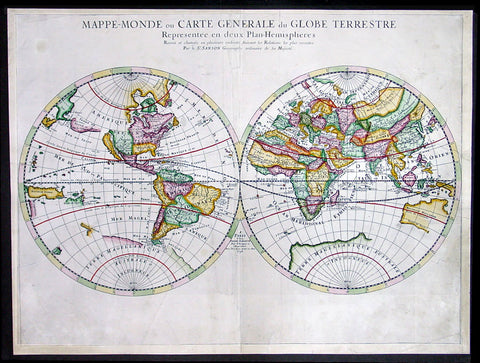
1678 Sanson Large Antique Twin Hemisphere World Map
- Title : Mappe-Monde ou Carte Generale du Globe Terrestre Represntee en Duex Plan Hemispheres...1678
- Date : 1678
- Condition: (A) Very Good Condition
- Ref: 35022
- Size: 23 1/2in x 17 1/2in (600mm x 445mm)
Description:
This large beautifully hand coloured originalantique Twin Hemisphere World Map was engraved by Pierre Mariette and published by Guillaume Sanson in 1678 - dated.
This elegant map is a progression of Nicolas Sanson's Twin Hemisphere World map of 1651. Nicolas drew this map for his 1660 atlas, and after his death in 1667, his sons Guillaume and Adrien used it in their atlases of 1669 and 1678.
This edition shows Australia with more definition, this along with Tasmania's coast and a small portion of New Zealand's coastline.
Background:
This map is the first to indicate N. Danemarckwest of the Hudson Bay, here named Mer Christiane. California is shown as an island, and Acoma and Santa Fe are noted in the Southwest, with Acoma shown correctly atop a mesa. The coastline of Asia is shown with the discoveries of the De Vries noted, including Terre de Iesso or Ieco, and a land called Yupi. The Great Lakes are not updated from the 1651 version, and do not show all five lakes. The map is typical of Sanson's "scientific" style of cartography with no decorative elements.
It was published in conjunction with Pierre Mariette (father and son), who published many of Sanson's works after 1645. (Ref: Shirley; Tooley; Koeman)
General Description:
Paper thickness and quality: - Heavy and stable
Paper color: - White
Age of map color: - Early
Colors used: - Yellow, green, pink
General color appearance: - Authentic
Paper size: - 23 1/2in x 17 1/2in (600mm x 445mm)
Plate size: - 23 1/2in x 15 1/2in (600mm x 395mm)
Margins: - Min 1/2in (12mm)
Imperfections:
Margins: - Light soiling
Plate area: - Light soiling, professional repair to & adjacent to centerfold
Verso: - None
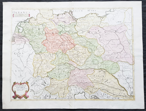
1689 Nicolas Sanson Large Antique Map of Germania & Central Europe
- Title : Germania Antiqua Aut N Sanson.....1689
- Ref #: 26191
- Size: 24in x 18 1/2in (610mm x 470mm)
- Date : 1689
- Condition: (A+) Fine Condition
Description:
This fine original hand coloured copper-plate engraved antique map of Germania & central Europe stretching from Poland to Italy to Denmark, by Nicolas Sanson, was engraved in 1689 - dated in the cartouche - and was published by Pierre Mariette in Cartes Generales de Toutes les Parties du Monde
General Definitions:
Paper thickness and quality: - Heavy and stable
Paper color : - off white
Age of map color: - Original & later
Colors used: - Yellow, green, blue, pink
General color appearance: - Authentic
Paper size: - 24in x 18 1/2in (610mm x 470mm)
Plate size: - 21 1/2in x 16in (545mm x 405mm)
Margins: - Min 1in (25mm)
Imperfections:
Margins: - None
Plate area: - None
Verso: - None
Background:
Germania was the Roman term for the geographical region in north-central Europe inhabited mainly by Germanic peoples.
It extended from the Danube in the south to the Baltic Sea, and from the Rhine in the west to the Vistula. The Roman portions formed two provinces of the Empire, Germania Inferior to the north (present-day southern Netherlands, Belgium, and western Germany), and Germania Superior to the south (Switzerland, southwestern Germany, and eastern France).
Germania was inhabited mostly by Germanic tribes, but also Celts, Balts, Scythians and later on Early Slavs. The population mix changed over time by assimilation, and especially by migration. The ancient Greeks were the first to mention the tribes in the area. Later, Julius Caesar wrote about warlike Germanic tribesmen and their threat to Roman Gaul, and there were military clashes between the Romans and the indigenous tribes. Tacitus wrote the most complete account of Germania that still survives.
The origin of the term Germania is uncertain, but was known by Caesars time, and may be Gaulish in origin.
Germania was inhabited by different tribes, most of them Germanic but also some Celtic, proto-Slavic, Baltic and Scythian peoples. The tribal and ethnic makeup changed over the centuries as a result of assimilation and, most importantly, migrations. The Germanic people spoke several different dialects.
Classical records show little about the people who inhabited the north of Europe before the 2nd century BC. In the 5th century BC, the Greeks were aware of a group they called Celts (Keltoi). Herodotus also mentioned the Scythians but no other tribes. At around 320 BC, Pytheas of Massalia sailed around Britain and along the northern coast of Europe, and what he found on his journeys was so strange that later writers refused to believe him. He may have been the first Mediterranean to distinguish the Germanic people from the Celts. Contact between German tribes and the Roman Empire did take place and was not always hostile. Recent excavations of the Waldgirmes Forum show signs that a civilian Roman town was established there, which has been interpreted to mean that Romans and Germanic tribesmen were living in peace, at least for a while.
Caesar described the cultural differences between the Germanic tribesmen, the Romans, and the Gauls in his book Commentarii de Bello Gallico, where he recalls his defeat of the Suebi tribes at the Battle of Vosges. He describes them at length at the beginning of Book IV and the middle of Book VI. He states that the Gauls, although warlike, had a functional society and could be civilized, but that the Germanic tribesmen were far more savage and were a threat to Roman Gaul and Rome itself. Caesar said the Germanic tribes were nomadic, with no notable settlements and a primitive culture. He used this as one of his justifications for why they had to be conquered. His accounts of barbaric northern tribes could be described as an expression of the superiority of Rome, including Roman Gaul.
Caesars accounts portray the Roman fear of the Germanic tribes and the threat they posed. The perceived menace of the Germanic tribesmen proved accurate. The most complete account of Germania that has been preserved from Roman times is Tacitus Germania.
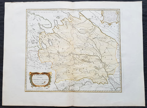
1741 Nicolas Sanson Large Antique Map of Sarmatia, Modern Day Russia & Ukraine
- Title : Sarmatia Utraque Europaea et Asiatica Autore Nicolas Sanson...1741
- Ref #: 50602
- Size: 27in x 20 1/4in (690mm x 515mm)
- Date : 1741
- Condition: (A+) Fine Condition
Description:
This fine original hand coloured copper-plate engraved antique map of the land of the Sarmatians - today stretching encompassing modern day European Russia and Ukraine and central Asia by Nicolas Sanson, was engraved in 1741 - dated in the cartouche - and was published by Robert De Vaugondy in a re-issue of Sansons atlas Cartes Generales de Toutes les Parties du Monde
General Definitions:
Paper thickness and quality: - Heavy and stable
Paper color : - off white
Age of map color: - Original & later
Colors used: - Yellow, green, blue, pink
General color appearance: - Authentic
Paper size: - 27in x 20 1/4in (690mm x 515mm)
Plate size: - 19in x 16 1/2in (485mm x 420mm)
Margins: - Min 2in (50mm)
Imperfections:
Margins: - None
Plate area: - None
Verso: - None
Background:
The Sarmatians were a large Iranian confederation that existed in classical antiquity, flourishing from about the 5th century BC to the 4th century AD.
Originating in the central parts of the Eurasian Steppe, the Sarmatians started migrating westward around the 4th and 3rd centuries BC, coming to dominate the closely related Scythians by 200 BC. At their greatest reported extent, around 1st century AD, these tribes ranged from the Vistula River to the mouth of the Danube and eastward to the Volga, bordering the shores of the Black and Caspian seas as well as the Caucasus to the south. Their territory, which was known as Sarmatia to Greco-Roman ethnographers, corresponded to the western part of greater Scythia (it included todays Central Ukraine, South-Eastern Ukraine, Southern Russia, Russian Volga and South-Ural regions, also to a smaller extent north-eastern Balkans and around Moldova). In the 1st century AD, the Sarmatians began encroaching upon the Roman Empire in alliance with Germanic tribes. In the 3rd century AD, their dominance of the Pontic Steppe was broken by the Germanic Goths. With the Hunnic invasions of the 4th century, many Sarmatians joined the Goths and other Germanic tribes (Vandals) in the settlement of the Western Roman Empire. Since large parts of todays Russia, actually the land between the Ural Mountains and the Don River, were controlled in the 5th century BC by the Sarmatians, Volga–Don and Ural steppes sometimes are also called Sarmatian Motherland.
The Sarmatians were eventually decisively assimilated (e.g. Slavicisation) and absorbed by the Proto-Slavic population of Eastern Europe.