Welcome to Classical Images!
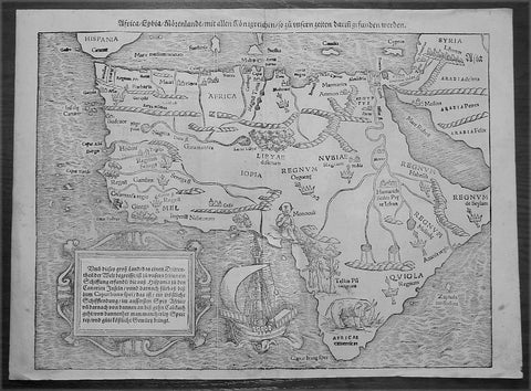
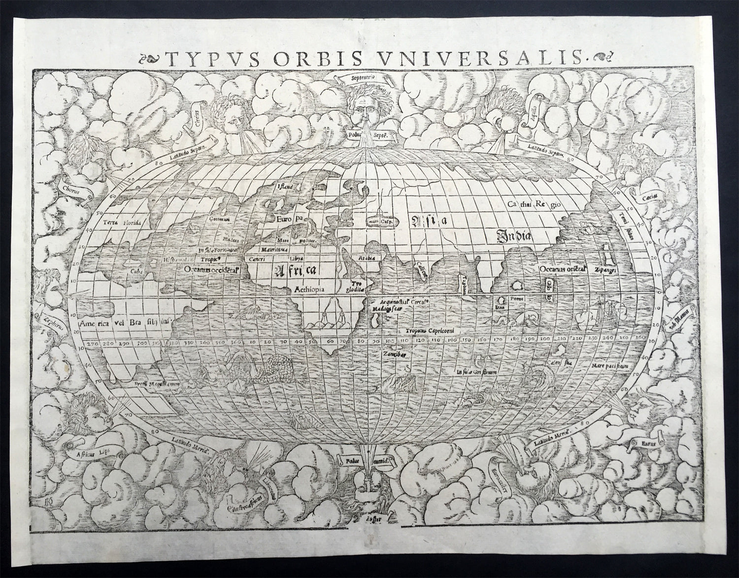
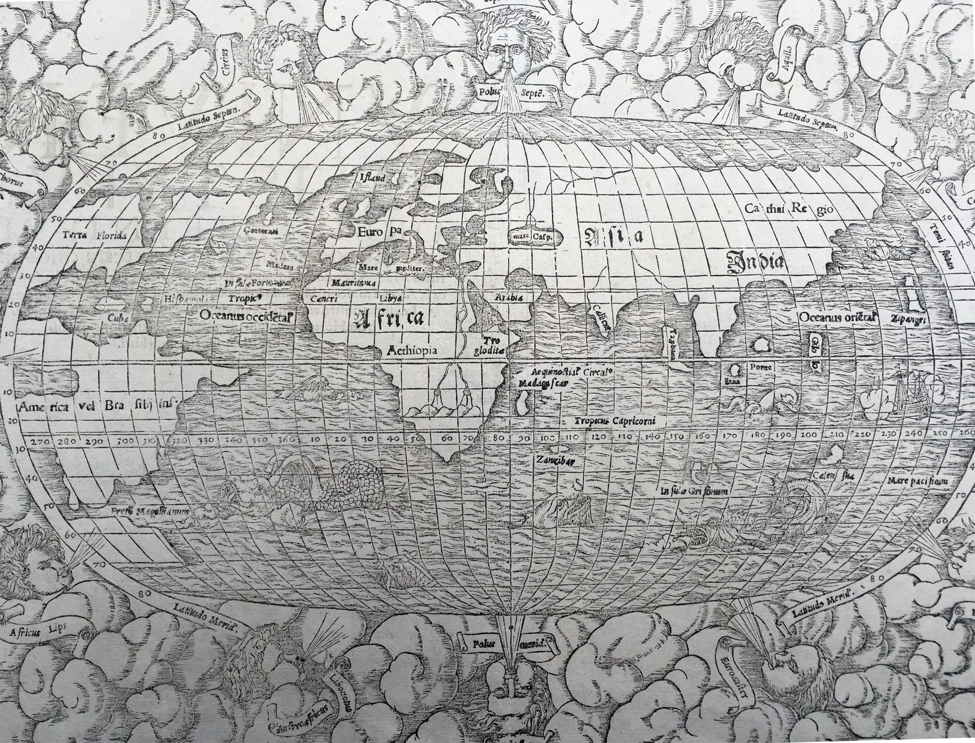
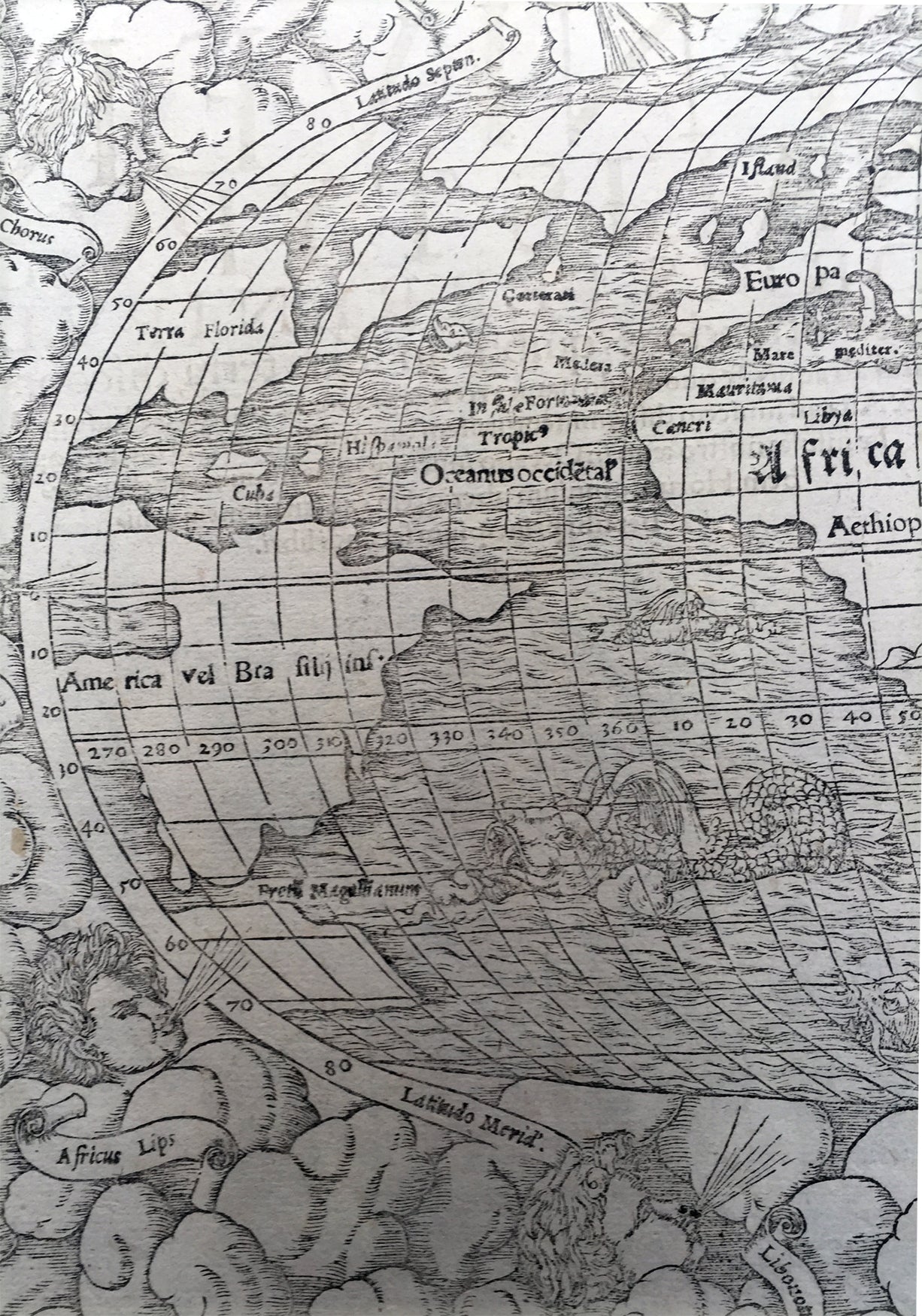
Description:This fine wood-block engraved original antique World Map was engraved by David Kandel, initials engraved bottom left "DK" and was published in the 1550 edition of Cosmographia by Sebastian Munster. One of the most recognizable maps of the 16th century considered the first map to identify the Pacific Ocean, as here, 'Mare Pacificum.' This is the world of the educated 16th century European, divided into Asia, Europe, India, Africa and America. The southern latitudes are inhabited by a variety of sea monsters and sailing ships. American continent is nearly unrecognizable, only a scant 58 years after European discovery by Christopher Columbus. North America is defined as Terra Florida showing an enormous inlet extending towards the eastern seaboard in the vicinity of modern day North Carolina named Verrazano's Sea. Apparently Verrazano, coasting the Outer Banks, observed the Pamlico Sound and assumed that beyond the narrow coastal banks, an open sea gave direct access to the pacific - wishful thinking at best. Verrazano's Sea appears so dramatically on few maps, but persisted in lesser forms for nearly a century. South America with tentacle like protrusions in all directions, is largely amorphous, but the Rio de la Plata and the Strait of Magellan are clear. Tierra del Fuego is enormous, with no mention of greater Terra Australias, an interesting omission by Munster. Europe is vaguely recognizable and connected, via an arctic peninsula, to Greenland and North America. Asia/Pacific extends eastward far enough to reappear just north of America. Ceylon is not present, but a landmass bearing roughly the shape and position of Sumatra is identified as Tapobrana (a term more commonly associated with Ceylon). Japan appears as Zipangri. Unlike many other world maps of the time, Munster has left out the concept of a 'Terra Australis Incognita' altogether choosing to show ocean instead. Africa follows the Ptolemaic model with the Nile finding its source in a mountain range and two associated lakes. The whole is surrounded by twelve named and prominent wind heads - one for each direction.
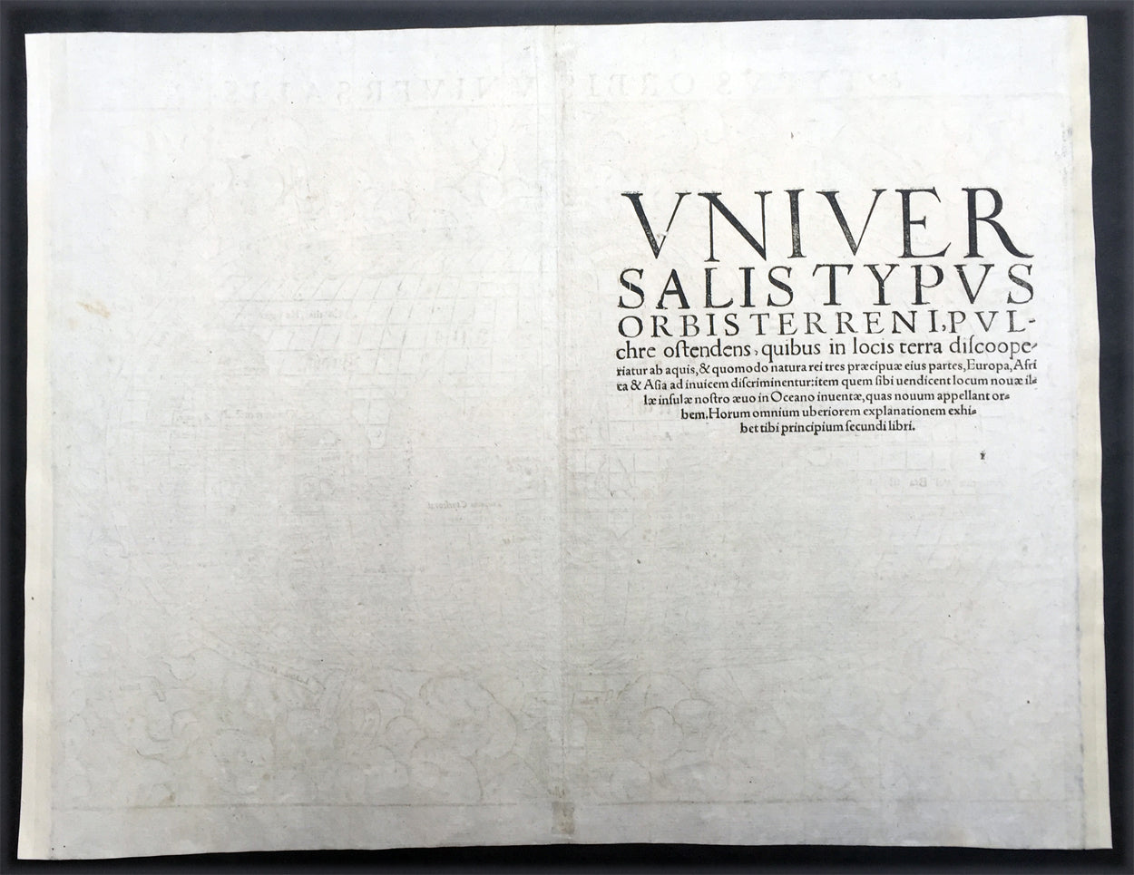
Background: This wood-cut engraved World map was prepared for the 1550 edition of Sebastian Münster's Cosmographia to replace the earlier World map by Sebasian Munster which had appeared in the editions of the Geographia and Cosmographia from 1540 onwards. The publisher, from 1552, was Heinrich Petri, Münster's son-in-law. This "new world" map is on an oval projection, similar in many respects to the previous Munster world map, but with the woodcutter's initials "DK" added, identified as those of the engraver David Kandel, in the lower left-hand corner. The titles of the wind-heads are now in banners and the east and west winds, unlike the 1540 version, do not protrude inside the oval circumference. North America still retains its unusual shape almost bisected by water but the earlier note indicating a route to the Moluccas has been omitted...." The map was first issued in the 1550 edition of Cosmographia, and appeared in all subsequent editions through to 1578, with the title varying according to the language of the edition. On the verso the wood block is the title and text, in Latin.
Sebastian Münster (1488-1552) was a German cartographer, cosmographer, and Hebrew scholar whose work Cosmographia (1544; "Cosmography") was the earliest German description of the world and a major work in the revival of geographic thought in 16th-century Europe. It had numerous editions in different languages including Latin, French, Italian, English, and even Czech. Altogether, about 40 editions of the Cosmographia appeared between 1544 and 1628 and was one of the most successful and popular books of the 16th century. Münster was a major influence in popular thinking in Europe for the next 200 years. This success was due not only to the level of descriptive detail but also to the fascinating full page maps & views as well as smaller woodcuts that were included in the text. Many of the woodcuts were executed by famous engravers of the time including Hans Holbein the Younger, Urs Graf, Hans Rudolph Manuel Deutsch, and David Kandel. Aside from the well-known maps present in the Cosmographia, the text is thickly sprinkled with vigorous views: portraits of kings and princes, costumes and occupations, habits and customs, flora and fauna, monsters, wonders, and horrors about the known -- and unknown -- world, and was undoubtedly one of the most widely read books of its time. Münster acquired the material for his book in three ways. Firstly he researched all available literary sources across Germany, Switzerland and other parts of Europe. Secondly he obtained original manuscript material from locals all over Europe for description of the countryside, cities, villages, towns, rivers and local history. Finally, he obtained further material first hand on his travels (primarily in south-west Germany, Switzerland, and Alsace). In 1588 Sebastian Petri re-released Cosomgraphia and re-issued many of Munsters maps and views in the "copperplate style". The maps in this release were more sophisticated than with earlier publications of Cosomgraphia and were based on the 1570 release of Abraham Ortelius monumental work Theatrum Orbis Terrarum. (Ref: Shirley; Tooley; M&B)
General Description: Paper thickness and quality: - Heavy and stable Paper color: - White Age of map color: - Colors used: - General color appearance: - Paper size: - 15 3/4in x 12 1/2in (400mm x 310mm) Plate size: - 15 3/4in x 12 1/2in (400mm x 310mm) Margins: - Min 1/2in (10mm) Imperfections: Margins: - L&R margins extended, not affecting borders or image Plate area: - None Verso: - None