
Gerard Mercator (1512 - 1594)
Background:
For nearly sixty years, during the most important and exciting period in the story of modern map making, Gerard Mercator was the supreme cartographer, his name, second only to Ptolemy, synonymous with the form of map projection still in use today. Although not the inventor of this type of projection he was the first to apply it to navigational charts in such a form that compass bearings could be plotted on charts in straight lines, thereby providing seamen with a solution to an age-old problem of navigation at sea. His influence transformed land surveying and his researches and calculations led him to break away from Ptolemy's conception of the size and outline of the Continents, drastically reducing the longitudinal length of Europe and Asia and altering the shape of the Old World as visualized in the early sixteenth century.
Mercator was born in Rupelmonde in Flanders and studied in Louvain under Gemma Frisius, Dutch writer, astronomer and mathematician. He established himself there as a cartographer and instrument and globe maker, and when he was twenty-five drew and engraved his first map (of Palestine) and went on to produce a map of Flanders (1540) supervising the surveying and completing the drafting and engraving himself. The excellence of his work brought him the patronage of Charles V for whom he constructed a globe, but in spite of his favour with the Emperor he was caught up in the persecution of Lutheran Protestants and charged with heresy, fortunately without serious consequences. No doubt the fear of further persecution influenced his move in 1552 to Duisburg, where he continued the production of maps, globes and instruments culminating in large-scale maps of Europe (1554), the British Isles (1564) and the famous World Map on 18 sheets drawn to his new projection (1569). All these early maps are exceedingly rare, some being known by only one copy.
In later life he devoted himself to his edition of the maps in Ptolemy's Geographia, reproduced in his own engraving as nearly as possible in their original form, and to the preparation of his 3-volume collection of maps to which, for the first time, the word 'Atlas' was applied. The word was chosen, he wrote, 'to honor the Titan, Atlas, King of Mauritania, a learned philosopher, mathematician, and astronomer' . The first two parts of the Atlas were published in 1585 and 1589 and the third, with the first two making a complete edition, in 1595 the year after Mercator's death.
Mercator's sons and grandsons named above, were all cartographers and made their contributions in various ways to the great atlas. Rumold, in particular, was responsible for the complete edition in 1595. After a second complete edition in 1602, the map plates were bought in 1604 by Jodocus Hondius who, with his sons, Jodocus II and Henricus, published enlarged editions which dominated the map market for the following twenty to thirty years
Gerard Mercator (39)
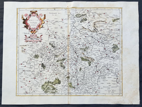
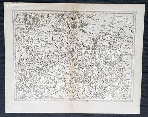
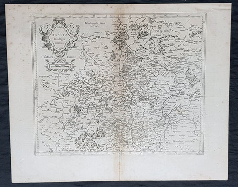
1589 Gerard Mercator Original 1st Ed. Antique Map of German State of Hesse
- Title : Hassia landtgrauiatus
- Date : 1589
- Size: 22 1/2in x 19in (570mm x 485mm)
- Ref #: 50254
- Condition: (A) Very Good Condition
Description:
This fine original and extremely scarce 1st edition antique map of the German State of Hesse or Hessia in central Germany was published by Gerard Mercator.
These original maps by Gerard Mercator from his original 16th century atlas are rare and hard to find. These original map are identifiable by the design on the verso of the map without the long description, scroll design and were engraved prior to the sale of Mercators plates to Hondius in the first decade of the 17th century.
General Definitions:
Paper thickness and quality: - Heavy and stable
Paper color : - off white
Age of map color: - Early
Colors used: - Yellow, green, blue, pink
General color appearance: - Authentic
Paper size: - 22 1/2in x 19in (570mm x 485mm)
Plate size: - 16 1/4in x 13 1/2in (415mm x 345mm)
Margins: - Min 1in (25mm)
Imperfections:
Margins: - None
Plate area: - Light browning along centerfold, light age toning
Verso: - Small repair to top centerfold
Background:
As early as the Paleolithic period, the Central Hessian region was inhabited. Due to the favorable climate of the location, people lived there about 50,000 years ago during the last glacial period, as burial sites show from this era. Finds of paleolitical tools in southern Hesse in Rüsselsheim suggest Pleistocene hunters about 13,000 years ago. The Züschen tomb (German: Steinkammergrab von Züschen, sometimes also Lohne-Züschen) is a prehistoric burial monument, located between Lohne and Züschen, near Fritzlar, Hesse, Germany. Classified as a gallery grave or a Hessian-Westphalian stone cist (hessisch-westfälische Steinkiste), it is one of the most important megalithic monuments in Central Europe. Dating to the late fourth millennium BC (and possibly remaining in use until the early third), it belongs to the Late Neolithic Wartberg culture.
An early Celtic presence in what is now Hesse is indicated by a mid-fifth-century BC La Tène-style burial uncovered at Glauberg. The region was later settled by the Germanic Chatti tribe around the first century BC, and the name Hesse is a continuation of that tribal name.
The ancient Romans had a military camp in Dorlar, and in Waldgirmes directly on the eastern outskirts of Wetzlar was a civil settlement under construction. Presumably, the provincial government for the occupied territories of the right bank of Germania was planned at this location. The governor of Germania, at least temporarily, likely had resided here. The settlement appears to have been abandoned by the Romans after the devastating Battle of the Teutoburg Forest failed in the year 9 AD. The Chatti were also involved in the Revolt of the Batavi in 69 AD.
Hessia, from the early seventh century on, served as a buffer between areas dominated by the Saxons (to the north) and the Franks, who brought the area to the south under their control in the early sixth century and occupied Thuringia (to the east) in 531. Hessia occupies the northwestern part of the modern German state of Hesse; its borders were not clearly delineated. Its geographic center is Fritzlar; it extends in the southeast to Hersfeld on the Fulda River, in the north to past Kassel and up to the rivers Diemel and Weser. To the west, it occupies the valleys of the Rivers Eder and Lahn (the latter until it turns south). It measured roughly 90 kilometers north-south, and 80 north-west.
The area around Fritzlar shows evidence of significant pagan belief from the first century on. Geismar was a particular focus of such activity; it was continuously occupied from the Roman period on, with a settlement from the Roman period, which itself had a predecessor from the fifth century BC. Excavations have produced a horse burial and bronze artifacts. A possible religious cult may have centered on a natural spring in Geismar, called Heilgenbron; the name \"Geismar\" (possibly \"energetic pool\") itself may be derived from that spring. The village of Maden, Gudensberg (de), now a part of Gudensberg near Fritzlar and less than ten miles from Geismar, was likely an ancient religious center; the basalt outcrop of Gudensberg is named for Wodan, and a two-meter tall quartz megalith called the Wotanstein is in the center of the village.
By 650, the Franks were establishing themselves as overlords, which is suggested by archeological evidence of burials, and were building fortifications in various places, including Christenberg. By 690, they were taking direct control over Hessia, apparently to counteract expansion by the Saxons, who built fortifications in Gaulskopf and Eresburg across the River Diemel, the northern boundary of Hessia. The Büraburg (which already had a Frankish settlement in the sixth century) was one of the places the Franks fortified to resist the Saxon pressure, and according to John-Henry Clay, the Büraburg was \"probably the largest man-made construction seen in Hessia for at least seven hundred years\". Walls and trenches totaling one kilometer in length were made, and they enclosed \"8 hectares of a spur that offered a commanding view over Fritzlar and the densely populated heart of Hessia\".
Following Saxon incursions into Chattish territory in the seventh century, two gaue had been established—a Frankish one, comprising an area around Fritzlar and Kassel, and a Saxon one. In the 9th century, the Saxon Hessengau also came under the rule of the Franconians. In the 12th, century it was passed to Thuringia.
In the War of the Thuringian Succession (1247–1264), Hesse gained its independence and became a Landgraviate within the Holy Roman Empire. It shortly rose to primary importance under Landgrave Philip the Magnanimous, who was one of the leaders of German Protestantism. After Philip\'s death in 1567, the territory was divided among his four sons from his first marriage (Philip was a bigamist) into four lines: Hesse-Kassel (or Hesse-Cassel), Hesse-Darmstadt, Hesse-Rheinfels, and the also previously existing Hesse-Marburg. As the latter two lines died out quite soon (1583 and 1605, respectively), Hesse-Kassel and Hesse-Darmstadt were the two core states within the Hessian lands. Several collateral lines split off during the centuries, such as in 1622, when Hesse-Homburg split off from Hesse-Darmstadt. In the late 16th century, Kassel adopted Calvinism, while Darmstadt remained Lutheran and subsequently the two lines often found themselves on different sides of a conflict, most notably in the disputes over Hesse-Marburg and in the Thirty Years\' War, when Darmstadt fought on the side of the Emperor, while Kassel sided with Sweden and France.
The Landgrave Frederick II (1720–1785) ruled as a benevolent despot, 1760–1785. He combined Enlightenment ideas with Christian values, cameralist plans for central control of the economy, and a militaristic approach toward diplomacy. He funded the depleted treasury of the poor nation by renting out 19,000 soldiers in complete military formations to Great Britain to fight in North America during the American Revolutionary War, 1776–1783. These soldiers, commonly known as Hessians, fought under the British flag. The British used the Hessians in several conflicts, including in the Irish Rebellion of 1798. For further revenue, the soldiers were rented out elsewhere, as well. Most were conscripted, with their pay going to the Landgrave.
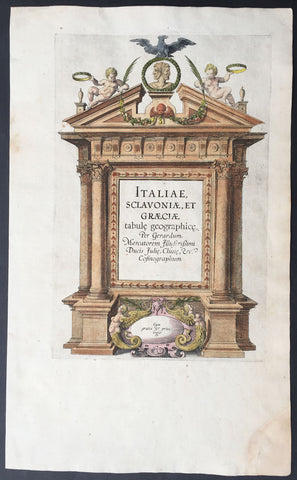
1589 Mercator Antique Atlas Title Page from Italy, Yugoslavia & Greece
-
Title : Italiae Sclavoniae, et Graeciae tabule geographice, per Gerardum Mercatorem....
- Date : 1589
- Condition: (A+) Fine Condition
- Ref: 16281
- Size: 16in x 10in (405mm x 255mm)
Description:
This beautifully engraved hand coloured original antique Title page from Gerard Mercator's Italy & SW Europe section was published in the 1589 edition of the Geographiaatlas.
After the sale of Mercator's plates to in 1605, Hondius continued to publish the original plates with little alteration until 1630 when along with Jansson many of the original plates were altered or re-engraved either decoratively or topographically or both. This map is from one of the last unaltered editions of Mercator's atlas. (Ref: Koeman, Tooley)
Condition Report
Paper thickness and quality: - Heavy and stable
Paper color: - off white
Age of map color: - Original
Colors used: - Red, yellow, green, blue
General color appearance: - Authentic
Paper size: - 16in x 10in (405mm x 255mm)
Plate size: - 11 1/2in x 7 1/2in (290mm x 190mm)
Margins: - Min 1in (25mm)
Imperfections:
Margins: - Repair to bottom right corner
Plate area: - None
Verso: - Age toning
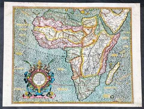
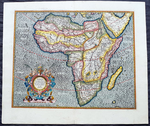
1595 Gerard Mercator Original True Rare 1st Edition Antique Map of Africa
- Title : Africa Ex Magna orbis terra descriptione Gerardi Mercatoris desumpta. Studio & industria GM Iunioris
- Size: 21in x 16 1/4in (535mm x 415mm)
- Condition: (A) Very Good Condition
- Date : 1595
- Ref #: 27016
Description:
This beautifully hand coloured original, true rare 1st edition* antique map, of Africa by Gerard Mercator was published in the 1595 Latin edition of Mercators Atlas, Atlas Sive Cosmographicae Meditationes Illustrissimi Ducis.
* True 1st edition identified on the verso of the map, according to Koemans Atlantes Neerlandica, illustrating the letter "C" under the title "Africa".
As indicated in the title Cartouche, this map this is a reduction by Gerard Mercator Junior of Africa, compiled from Gerard Mercators world map of 1569. This rendition was drawn by Mercators grandson (also named Gerard) in 1595.
The map is typical of 16th century cartography of Africa containing some fantastical detail especially in regards to the interior. The depiction of the Nile is based on Ptolemys geography with some complex modifications from various sources, including Abyssinian monks. The source of the Nile is shown as a series of lakes located in the Lune Montes just north of the Tropic of Capricorn. Another branch of the Nile flows from the west, with this system rambling through what is the Sahara Desert. Mercator adds a lake named Sac. Haf lac, from the 1507 Waldseemuller world map. This lake feeds both the Zambere River and the Nile. In Abissini, the legendary Christian King Prester John sits on his throne. The boldly engraved oceans, beautiful calligraphy, and strapwork cartouche (surmounted by two satyrs) make this a decorative masterpiece.
General Definitions:
Paper thickness and quality: - Heavy and stable
Paper color : - off white
Age of map color: - Original
Colors used: - Yellow, green, blue, pink
General color appearance: - Authentic
Paper size: - 21in x 16 1/4in (535mm x 415mm)
Plate size: - 18 1/2in x 15in (470mm x 380mm)
Margins: - Min 1/2in (12mm)
Imperfections:
Margins: - Age toning, small rejoin in bottom right margin
Plate area: - None
Verso: - Age toning, left & top margin re-enforced
Background:
Being part of the Mediterranean world, the northern coasts of the African continent as far as the Straits of Gibraltar and even round to the area of the Fortunate Isles (the Canaries) were reasonably well known and quite accurately mapped from ancient times. In particular, Egypt and the Nile Valley were well defined and the Nile itself was, of course, one of the rivers separating the continents in medieval T-O maps. Through Arab traders the shape of the east coast, down the Red Sea as far as the equator, was also known but detail shown in the interior faded into deserts with occasional mountain ranges and mythical rivers. The southern part of the continent, in the Ptolemaic tradition, was assumed to curve to the east to form a land-locked Indian Ocean. The voyages of the Portuguese, organized by Henry the Navigator in the fifteenth century, completely changed the picture and by the end of the century Vasco da Gama had rounded the Cape enabling cartographers to draw a quite presentable coastal outline of the whole continent, even if the interior was to remain largely unknown for the next two or three centuries.
The first separately printed map of Africa (as with the other known continents) appeared in Munster\'s Geographia from 1540 onwards and the first atlas devoted to Africa only was published in 1588 in Venice by Livio Sanuto, but the finest individual map of the century was that engraved on 8 sheets by Gastaldi, published in Venice in 1564. Apart from maps in sixteenth-century atlases generally there were also magnificent marine maps of 1596 by Jan van Linschoten (engraved by van Langrens) of the southern half of the continent with highly imaginative and decorative detail in the interior. In the next century there were many attractive maps including those of Mercator/Hondius (1606), Speed (1627), Blaeu (1 630), Visscher (1636), de Wit (c. 1670), all embellished with vignettes of harbours and principal towns and bordered with elaborate and colourful figures of their inhabitants, but the interior remained uncharted with the exception of that part of the continent known as Ethiopia, the name which was applied to a wide area including present-day Abyssinia. Here the legends of Prester John lingered on and, as so often happened in other remote parts of the world, the only certain knowledge of the region was provided by Jesuit missionaries. Among these was Father Geronimo Lobo (1595-1678), whose work A Voyage to Abyssinia was used as the basis for a remarkably accurate map published by a German scholar, Hiob Ludolf in 1683. Despite the formidable problems which faced them, the French cartographers G. Delisle (c. 1700-22), J. B. B. d\'Anville (1727-49) and N. Bellin (1754) greatly improved the standards of mapping of the continent, improvements which were usually, although not always, maintained by Homann, Seutter, de Ia Rochette, Bowen, Faden and many others in the later years of the century.
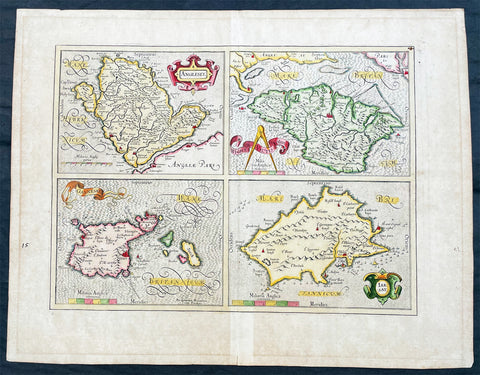
1606 Gerard Mercator Antique Map British Islands Anglesey, Wight Guernsey Jersey
- Title : Anglesey; Wight Vectis, olim; Garnesay: Jarsay
- Ref #: 17014
- Size: 21 1/2in x 17in (550mm x 430mm)
- Date : 1606
- Condition: (A+) Fine Condition
Description:
This beautifully hand coloured original copper plate engraved antique map of the 4 British Islands of Anglesey, Wight Guernsey Jersey by Gerard Mercator was published by Henricus Hondius in the 1606 edition of Mercators Atlas, Atlas Sive Cosmographicae Meditationes Illustrissimi Ducis.
This map is beautiful with early original hand colour, heavy dark impression, on heavy paper and original margins.
General Definitions:
Paper thickness and quality: - Heavy and stable
Paper color : - off white
Age of map color: - Early
Colors used: - Yellow, green, blue, pink
General color appearance: - Authentic
Paper size: - 21 1/2in x 17in (550mm x 430mm)
Plate size: - 17 1/4in x 12 1/2in (440mm x 315mm)
Margins: - Min 2in (50mm)
Imperfections:
Margins: - Age toning in margins
Plate area: - None
Verso: - Age Toning
Anglesey is an island off the north-west coast of Wales. The English name of the island may be derived from the Old Norse; either Ǫngullsey Hook Island or Ǫnglisey Ǫngli's Island. No record of such an Ǫngli survives, but the place name was used by Viking raiders as early as the 10th century and later adopted by the Normans during their invasions of Gwynedd. The traditional folk etymology reading the name as the Island of the Angles (English)] may account for its Norman use but has no merit, as the Angles name itself is probably cognate with the shape of the Angeln peninsula. All of them ultimately derive from the proposed Proto-Indo-European root *ank- (to flex, bend, angle). Throughout the 18th and 19th centuries and into the 20th, it was usually spelt Anglesea in documents.
The oldest records that give a name for the Isle of Wight are from the Roman Empire: it was then called Vectis or Vecta in Latin, Iktis or Ouiktis in Greek. From the Anglo-Saxon period Latin Vecta, Old English Wiht and Old Welsh forms Gueid and Guith are recorded. In Domesday Book it is Wit; the modern Welsh name is Ynys Wyth (ynys = island). These are all variant forms of the same name, possibly Celtic in origin. It may mean "place of the division", because the island divides the two arms of the Solent.
The Channel Islands are an archipelago of British Crown Dependencies in the English Channel, off the French coast of Normandy. They include two separate bailiwicks: the Bailiwick of Jersey and the Bailiwick of Guernsey. They are considered the remnants of the Duchy of Normandy, and are not part of the United Kingdom. They have a total population of about 168,000 and their respective capitals, Saint Helier and Saint Peter Port, have populations of 33,500 and 16,488, respectively. The total area of the islands is 194 km.
Both Bailiwicks have been administered separately since the late 13th century; each has its own independent laws, elections, and representative bodies (although in modern times, politicians from the islands' legislatures are in regular contact). Any institution common to both is the exception rather than the rule.
Please note all items auctioned are genuine, we do not sell reproductions. A Certificate of Authenticity (COA) can be issued on request.
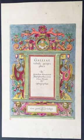
1606 Mercator Old, Antique Atlas Title Page of Geographia Atlas on France
- Title : Galliae tabule Geograpicae per Gerardum Mercatorem Fllustrissimi Ducis...
- Ref #: 92698
- Size: 18in x 10 1/2in (460mm x 270mm)
- Date : 1606
- Condition: (A+) Fine Condition
Description:
This beautifully hand coloured original antique Title Page* was published as the Front Piece of Gerard Mercator's edition of the Geographia Atlas of France, published in 1606.
After the sale of Mercator's plates to Henricus Hondius in 1605, Hondius continued to publish the original plates with little alteration until 1630 when, along with Jan Jansson, many of the original plates were altered and published in new editions of Mercator's atlas. (Ref: Koeman, Tooley)
Condition Report
Paper thickness and quality: - Heavy and stable
Paper color: - off white
Age of map color: - Original
Colors used: - Red, yellow, green, blue
General color appearance: - Authentic
Paper size: - 18in x 10 1/2in (460mm x 270mm)
Plate size: - 13in x 9in (330mm x 230mm)
Margins: - Min 1in (25mm)
Imperfections:
Margins: - Uniform age toning
Plate area: - None
Verso: - Age toning
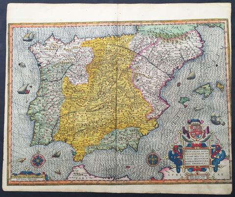
1607 Mercator Antique Map of Spain & Portugal
- Title : Hispania Nova Descriptio de Integro...Petrus Kaerius
- Date : 1607
- Condition: (A) Very Good Condition
- Ref: 42002
- Size: 20in x 18in (510mm x 430mm)
Description:
This fine beautifully hand coloured original antique map of Spain & Portugal by Gerard Mercator was published by Rumold Mercator &Jodocus Hondius in the very early 1607 Latin edition of Mercators Atlas.
This map is magnificent with beautiful original hand colouring. Original colouring such as this is scarce and hard to find.
These maps, published in the early editions of Mercators atlas, are the original maps drawn and engraved by Gerald Mercator in the mid to late 16th century, published by his son Rumold as an atlas, after his death, in 1595. After two editions the plates were purchased by Jodocus Hondius in 1604 and continued to be published until the mid 1630's when the plates were re-engraved and updated by Jan Jansson and Henricus Hondius.
Background:
Many of the original charts and maps drawn by the first Portuguese and Spanish navigators have survived for the very good reason that, on completion of their voyages, pilots were obliged to hand over their manuscript notes to the Casa da India (founded 1504) in Lisbon or to the equivalent Casa de Contrataci6n de las Indias (founded 1504) in Seville. The clear intention was to maintain secrecy over new discoveries and control over the distribution of cartographic material, not always successfully, as it happened; pilots and navigators seem to have changed allegiance with impunity and, in consequence, many of the earliest and most informative charts were compiled as far away as Genoa, Venice, Florence and Ancona, presumably from sources outside the Portuguese and Spanish 'Casas'.It is apparent that few manuscripts reached the printing stage and, indeed, are so rare that any study of them must be regarded as a specialist subject. (Ref Tooley M&B)(Ref: Koeman; Tooley)
Condition Report:
Paper thickness and quality: - Heavy and stable
Paper color: - off white
Age of map color: - Original
Colors used: - Yellow, red, green, purple, blue
General color appearance: - Authentic
Paper size: - 20in x 18in (510mm x 430mm)
Plate size: - 20in x 16in (420mm x 380mm)
Margins: - Min 0in (0mm)
Imperfections:
Margins: - Left margin cropped into border
Plate area: - Light creasing along centerfold
Verso: - Light re-enforcing along centerfold
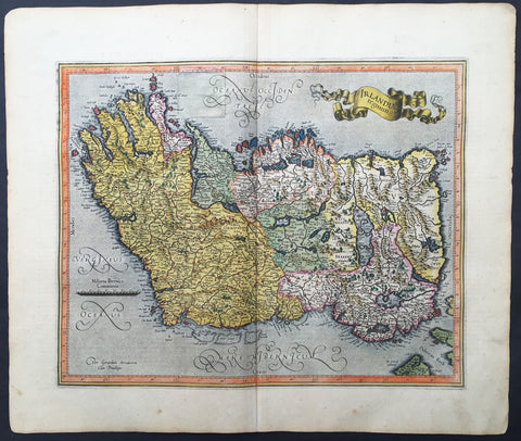
1607 Mercator Hondius Original Antique Map of Ireland - Rare and beautiful
- Title : Irlandiae regnum
- Date : 1607
- Condition: (A) Very Good Condition
- Ref: 42003
- Size: 20in x 18in (560mm x 430mm)
Description:
This fine beautifully hand coloured original antique map of Ireland by Gerald Mercator was published by Rumold Mercator & Jodocus Hondius in the very early 1607 Latin edition of Mercators Atlas.
This map is magnificent with beautiful original hand colouring. Original colouring such as this is scarce and hard to find.
These maps, published in the early editions of Mercators atlas, are the original maps drawn and engraved by Gerald Mercator in the mid to late 16th century, published by his sons Rumold & Henricus as an atlas, after his death, in 1595. After two editions the plates were purchased by Jodocus Hondius in 1604 and continued to be published until the mid 1630's when the plates were re-engraved and updated by Jan Jansson and Henricus Hondius.
The earliest maps of Ireland up to the year 1500 or so share the shortcomings of those of the rest of the British Isles especially as represented on world maps. It was not to be expected that lands literally on the very edge of the known world could be depicted with any accuracy; very often one feels that the cartographers or engravers placed the islands in the nearest available space consistent with their imagined position. Even in the first printed Ptolemaic map there is still much distortion in Ireland's shape and geographical position but, on the other hand, a quite surprising number of place names and other details are shown, as many, in fact, as in the rest of Britain put together. This detailed knowledge is not as puzzling as it might appear, for the Ptolemy maps, at least the later editions from 1513 onwards, were based on Italian portulan charts and these, in turn, reflected knowledge gained during the long commercial relationship which had existed between Italy and Ireland ever since the thirteenth century. The distortions on land-surveyed maps remained uncorrected until late in the seventeenth century but a quite accurate coastal outline was given in the marine atlases of Waghenaer, Dudley, Blaeu and later Dutch chart makers.
Apart from a few manuscript maps and very rare maps printed in Rome and Venice (George Lily, 1546, and others in the period 1560-66) Ireland is shown on Mercator's large map of the British Isles (1564), and in his Atlas (1595) and as a separate sheet in the Ortelius atlases (from 1 573). The most important map, however, was compiled by an Italian, Baptista Boazio, probably in the 1 5 8os. This has survived in manuscript form and may have been used by Pieter van der Keere for a map published by Jodocus Hondius in 1591. Boazio's map was subsequently published by John Sudbury, who later sold Speed's maps, and this version was included in editions of the Ortelius atlases from 6oz onwards. The Boazio map is a quite splendid map, very decorative, some copies even showing an Eskimo complete with kayak and hunting spear. Thereafter the trend is familiar: Camden, Speed, Blaeu, Jansson, Sanson and others of the Dutch and French schools all included a general map or maps of the Irish provinces in their atlases. Speed's map of the whole of Ireland was based at least partly on surveys by Robert Lythe (c.1570) and Francis Jobson(c.1590) and included figures in national costume; it was for long regarded as the best map available and was much copied by publishers in other countries.
In 1685 the first atlas of Ireland to match Saxton's At/as of Eng/andand Wales was published by Sir William Petty as Hiberniae Detineaho, the result of a highly organized and detailed survey (the 'Down' survey) carried out in the years following 1655. Re-issued in miniature form soon afterwards by Francis Lamb, Petty's Atlas was widely used as the basis for practically all maps of Ireland produced by English, French, Dutch and German publishers in the following century. Apart from re-issues of Petty's Atlas and its many copyists there were maps by George Grierson, a Dublin publisher, John Rocque, the Huguenot surveyor and engraver who spent some years in Dublin, and Bernard Scale, Rocque's brother-in-law.
Towards the end of the century many large-scale maps were published but, as in England, private mapping was gradually overtaken and eventually replaced by the Ordnance Survey maps produced between the years 1824 and 1846.(Ref: Koeman, Tooley)
Condition Report:
Paper thickness and quality: - Heavy and stable
Paper color: - off white
Age of map color: - Original
Colors used: - Yellow, red, green, purple, blue
General color appearance: - Authentic
Paper size: - 20in x 18in (560mm x 430mm)
Plate size: - 17 1/2in x 14in (420mm x 330mm)
Margins: - Min 1in (25mm)
Imperfections:
Margins: - Light age toning to margins
Plate area: - Old professional repair to 45mm sq to left side
Verso: - Old professional repair to text "H"
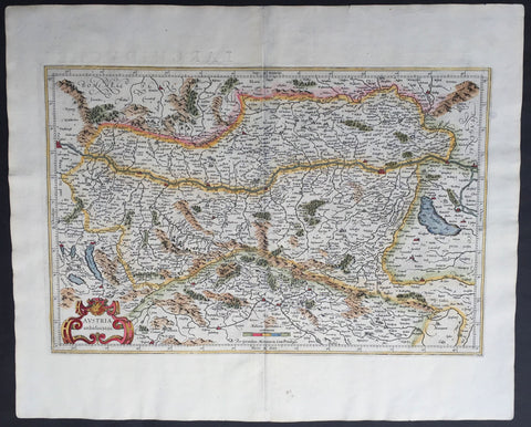
1609 Mercator & Hondius Large Antique Map of Austria
- Title : Austria Archiducatus
- Ref #: 60052
- Size: 22in x 18in (560mm x 460mm)
- Date : 1609
- Condition: (A+) Fine Condition
Description:
This beautifully engraved hand coloured original antique map of Austria was published in the 1609 French edition of Mercators Atlas published by Henricus Hondius and Jan Jansson.
These maps, published in the later editions of Mercators atlas, are derived from the original maps drawn and engraved by Gerald Mercator in the mid to late 16th century, published by his son Rumold as an atlas, after his death, in 1595. After two editions the plates were purchased by Jodocus Hondius in 1604 and continued to be published until the mid 1630's when the plates were re-engraved and updated by Jan Jansson and Henricus Hondius.
Condition Report
Paper thickness and quality: - Heavy and stable
Paper color: - off white
Age of map color: - Early
Colors used: - Red, yellow, green
General color appearance: - Authentic
Paper size: - 22in x 18in (560mm x 460mm)
Plate size: - 19 1/2in x 13in (485mm x 330mm)
Margins: - Min 1in (25mm)
Imperfections:
Margins: - None
Plate area: - None
Verso: - None
1613 Gerard Mercator Large Antique Map of Africa - Africa Ex Magna
- Title : Africa Ex Magna orbis terra descriptione Gerardi Mercatoris desumpta. Studio & industria GM Iunioris
- Size: 22in x 18 3/4in (560mm x 475mm)
- Condition: (A+) Fine Condition
- Date : 1613
- Ref #: 34173
Description:
This beautifully hand coloured original antique map of Africa by Gerard Mercator was published by Henricus Hondius in the 1613 French edition of Mercators Atlas, Atlas Sive Cosmographicae Meditationes Illustrissimi Ducis.
This map is exceptional with original hand colour, heavy dark impression, clean heavy paper and original margins.
As indicated in the title Cartouche, this map this is a reduction by Gerard Mercator Junior of Africa, compiled from Gerard Mercator\'s world map of 1569. This rendition was drawn by Mercator\'s grandson (also named Gerard) in 1595.
The map is typical of 16th century cartography of Africa containing some fantastical detail especially in regards to the interior. The depiction of the Nile is based on Ptolemys geography with some complex modifications from various sources, including Abyssinian monks. The source of the Nile is shown as a series of lakes located in the Lune Montes just north of the Tropic of Capricorn. Another branch of the Nile flows from the west, with this system rambling through what is the Sahara Desert. Mercator adds a lake named Sac. Haf lac, from the 1507 Waldseemuller world map. This lake feeds both the Zambere River and the Nile. In Abissini, the legendary Christian King Prester John sits on his throne. The boldly engraved oceans, beautiful calligraphy, and strapwork cartouche (surmounted by two satyrs) make this a decorative masterpiece.
General Definitions:
Paper thickness and quality: - Heavy and stable
Paper color : - off white
Age of map color: - Original
Colors used: - Yellow, green, blue, pink
General color appearance: - Authentic
Paper size: - 22in x 18 3/4in (560mm x 475mm)
Plate size: - 18 1/2in x 15in (470mm x 380mm)
Margins: - Min 1in (25mm)
Imperfections:
Margins: - None
Plate area: - None
Verso: - None
Background:
Being part of the Mediterranean world, the northern coasts of the African continent as far as the Straits of Gibraltar and even round to the area of the Fortunate Isles (the Canaries) were reasonably well known and quite accurately mapped from ancient times. In particular, Egypt and the Nile Valley were well defined and the Nile itself was, of course, one of the rivers separating the continents in medieval T-O maps. Through Arab traders the shape of the east coast, down the Red Sea as far as the equator, was also known but detail shown in the interior faded into deserts with occasional mountain ranges and mythical rivers. The southern part of the continent, in the Ptolemaic tradition, was assumed to curve to the east to form a land-locked Indian Ocean. The voyages of the Portuguese, organized by Henry the Navigator in the fifteenth century, completely changed the picture and by the end of the century Vasco da Gama had rounded the Cape enabling cartographers to draw a quite presentable coastal outline of the whole continent, even if the interior was to remain largely unknown for the next two or three centuries.
The first separately printed map of Africa (as with the other known continents) appeared in Munster\'s Geographia from 1540 onwards and the first atlas devoted to Africa only was published in 1588 in Venice by Livio Sanuto, but the finest individual map of the century was that engraved on 8 sheets by Gastaldi, published in Venice in 1564. Apart from maps in sixteenth-century atlases generally there were also magnificent marine maps of 1596 by Jan van Linschoten (engraved by van Langrens) of the southern half of the continent with highly imaginative and decorative detail in the interior. In the next century there were many attractive maps including those of Mercator/Hondius (1606), Speed (1627), Blaeu (1 630), Visscher (1636), de Wit (c. 1670), all embellished with vignettes of harbours and principal towns and bordered with elaborate and colourful figures of their inhabitants, but the interior remained uncharted with the exception of that part of the continent known as Ethiopia, the name which was applied to a wide area including present-day Abyssinia. Here the legends of Prester John lingered on and, as so often happened in other remote parts of the world, the only certain knowledge of the region was provided by Jesuit missionaries. Among these was Father Geronimo Lobo (1595-1678), whose work A Voyage to Abyssinia was used as the basis for a remarkably accurate map published by a German scholar, Hiob Ludolf in 1683. Despite the formidable problems which faced them, the French cartographers G. Delisle (c. 1700-22), J. B. B. d\'Anville (1727-49) and N. Bellin (1754) greatly improved the standards of mapping of the continent, improvements which were usually, although not always, maintained by Homann, Seutter, de Ia Rochette, Bowen, Faden and many others in the later years of the century.
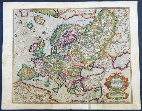
1613 Gerard Mercator Large Antique Map of Europe - Europa ad Magnae
- Title : Europa ad magnae Europae Gerardi Mercatoris P. imitationem Rumoldi Mercatoris . . ..
- Date : 1613
- Condition: (A) Very Good Condition
- Ref: 93357
- Size: 21 1/2in x 17in (545mm x 435mm)
Description:
The beautiful original hand colouring on this map is incredibly striking, on this original antique map of Europe published in the 1613 French edition of Gerard Mercators Atlas Sive Cosmographia.
General Definitions:
Paper thickness and quality: - Heavy and stable
Paper color : - off white
Age of map color: - Original
Colors used: - Blue, pink, red, green, yellow
General color appearance: - Authentic
Paper size: - 21 1/2in x 17in (545mm x 435mm)
Plate size: - 18 1/2in x 15 1/4in (470mm x 390mm)
Margins: - Min 1/2in (12mm)
Imperfections:
Margins: - Soiling, age toning, old neutralised tape mark bottom right
Plate area: - Neutralised tape mark bottom right
Verso: - Soiling, age toning, old neutralised tape mark
Background:
The detail for the map is taken from Mercators large 1569 world wall map and includes much detail, both real and fictitious. The original colouring denotes the political country boundaries of the 15th & 16th centuries. To the north are shown the islands of the Northern Arctic, Terra Polaris Pars, Greenland and the eastern extremity of America. To the south of Iceland is the fictitious island of Frisland where the Venetian brothers Nicolo and Antonio Zeno claimed where they were stranded after discovering America before Columbus. The younger Zeno produced a map describing these false discoveries. Mercator accepted these falsehoods and copied them into this map. Other cartographers at this time were fooled by Mercator and also copied his mistake. Frisland appears more dominate than the real island of Iceland.
The map is beautifully engraved, with Mercators recognisable flair and beautiful, rare original hand colouring. A beautiful map

1613 Mercator Antique Map of America & The Great Southern Land - Terra Australis
- Title : America sive India Nova. ad magna Gerardi Mercatoris aui Universalis imitationem in compendium redacta. Per Michaelem Mercatorem Duysburgensem
- Ref #: 61033
- Size: 20 1/2in x 17 1/2in (510mm x 445mm)
- Date : 1613
- Condition: (A+) Fine Condition
Description:
This fine beautifully hand coloured original antique early map of America and the Great Southern Continent (Terra Australis) that was envisaged in the southern Hemisphere, prior to the discovery of Australia by Captain Cook in 1769 - the only map attributed to Gerard Mercator's Grandson Michael - was published in the 1633 French edition of Mercator's Atlas.
This map is magnificent with beautiful original hand colouring, wide margins and stable paper. Backed with transparent archival Japanese paper. Original colouring such as this is scarce and hard to find.
Condition Report:
Paper thickness and quality: - Heavy and stable
Paper color: - off white
Age of map color: - Original
Colors used: - Yellow, red, green, orange, blue
General color appearance: - Authentic
Paper size: - 21 1/2in x 17 3/4in (545mm x 450mm)
Plate size: - 18 1/2in x 14 3/4in (470mm x 376mm)
Margins: - Min 1in (25mm)
Imperfections:
Margins: - Light soiling in margins
Plate area: - None
Verso: - None
Background: Largely based on Rumold Mercator's world map of 1587, this map aptly reflects 16th-century knowledge, theories and suppositions regarding the New World. Naturally, most of this new knowledge was coastal, and configurations of any large areas were greatly hampered by the lack of a sound means of determining longitude. Nevertheless, the collective accomplishment of explorers and mapmakers represented in this map is astounding, showing in a generally correct way the vast extent of the New World. "A few of the most famous theories are still present: a large inland lake in Canada, two of the four islands of the North Pole, a bulge to the west coast of South America and the large southern continent" (Burden).
The map appeared in 1595 and 1606 editions of the Atlantis Pars Altera , after which the plate was sold to Jodocus Hondius, who reissued the maps in varying editions through 1639. The present example includes French text on verso, confirming it to be a Hondius issue.
Several of the more fascinating theories are present, including the multiple islands of the North Polar Sea, bulging South America and vast unknown southern continent. The St. Lawrence crosses half the continent. No sign of the English in Virginia. The search for a water course across North America is interupted only by some mid-continental mountains. Evidence of the Spanish explorations in the Southwest is present and the Colorado and Gila Rivers already reflect a good knowledge of this area, as does the peninsular Baja California, based upon Uloa's work.
The depiction of the NW Passage and Western North America are also of great interest. Annotations reference the voyages of Columbus and Magellan.(Ref: Burden; Koeman; Tooley; M&B)
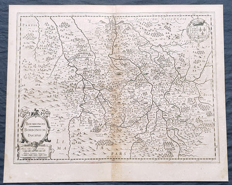
1628 Gerard Mercator & Henricus Hondius Antique Map Bourbonnais Region of France
- Title : Boubonoius; Borbonium Ducatus....
- Size: 21in x 17in (530mm x 430mm)
- Condition: (A) Very Good Condition
- Date : 1628
- Ref #: 26138
Description:
This original copper plate engraved antique map of the Bourbon or Bourbonnais Region of central France by Gerard Mercator was published by Henricus Hondius in the early 1628 French edition of Gerard Mercators Atlas.
These maps, published in the early editions of Mercators atlas, are the original maps drawn and engraved by Gerald Mercator in the mid to late 16th century, published by his son Rumold as an atlas, after his death, in 1595. After two editions the plates were purchased by Jodocus Hondius in 1604, and continued to be published until the end of the 1630s by Henricus Hondius, when some of the plates were re-engraved and updated with the help of Jan Jansson.
General Definitions:
Paper thickness and quality: - Heavy and stable
Paper color : - off white
Age of map color: -
Colors used: -
General color appearance: -
Paper size: - 21in x 17in (530mm x 430mm)
Plate size: - 18 1/2in x 14in (475mm x 350mm)
Margins: - Min 1/2in (12mm)
Imperfections:
Margins: - Light age toning
Plate area: - Light toning along centerfold
Verso: - Light age toning
Background:
Bourbonnais was a historic province in the centre of France that corresponded to the modern département of Allier, along with part of the département of Cher. Its capital was Moulins.
The title of the ruler of Bourbonnais between 913 and 1327, was Sire de Bourbon (or Seigneur de Bourbon). The first lord of Bourbonnais known by name was Adhémar (or Aymon I of Bourbon). Aymon\\\'s father was Aymar (894-953), sire of Souvigny, his only son with Ermengarde.Aymar lived during the reign of Charles the Simple who, in 913, gave him fiefs on the Allier River in which would become Bourbonnais. He acquired the castle of Bourbon (today Bourbon-l\\\'Archambault). Almost all early lords took the name d\\\'Archambaud, after the palace, but later the family became known as the \\\"House of Bourbon\\\".
The first House of Bourbon ended in 1196, with the death of Archambault VII, who had only one heir, Mathilde of Bourbon. She married Guy II of Dampierre, who added Montlucon to the possessions of the lords of Bourbon. The second house of Bourbon started in 1218, with Archambault VIII, son of Guy II and Mahaut, and brother of William II of Dampierre. He was followed by his son Archambaut IX, who died in Cyprus in 1249, during a crusade. The House of Burgundy then acquired Bourbonnais.
In 1272, Beatrice of Burgundy (1258-1310), Lady of Bourbon, married Robert de France (1256-1318), Count of Clermont, son of king Louis IX (Saint-Louis). Thus began the long-lasting House of Bourbon, which would provide the kings of France from Henry IV to Louis-Phillipe in 1848, when France abolished its monarchy.
The Bourbons had concluded an alliance with the royal power. They put their forces at the service of the king, thus benefitting from the geographic position of Bourbonnais, located between the royal fidemesne and the duchies of Aquitaine and Auvergne. This alliance, as well as the marriage of Béatrix de Bourgogne and Robert de France, aided the rise and prosperity of the province. In 1327, King Charles (le Bel) elevated Boubonnais to the status of a duchy. (Ref: Koeman; M&B; Tooley)
1628 Gerard Mercator & Henricus Hondius Antique Map Canton of Aargau Switzerland
- Title : Argow...Per Geradum Mercatorem Cum Privilego...
- Size: 21in x 17in (530mm x 430mm)
- Condition: (A) Very Good Condition
- Date : 1628
- Ref #: 26090
Description:
This original copper plate engraved antique map of the Canton of Aargau, Switzerland by Gerard Mercator was published by Henricus Hondius in the early 1628 French edition of Gerard Mercators Atlas.
These maps, published in the early editions of Mercators atlas, are the original maps drawn and engraved by Gerald Mercator in the mid to late 16th century, published by his son Rumold as an atlas, after his death, in 1595. After two editions the plates were purchased by Jodocus Hondius in 1604, and continued to be published until the end of the 1630s by Henricus Hondius, when some of the plates were re-engraved and updated with the help of Jan Jansson.
General Definitions:
Paper thickness and quality: - Heavy and stable
Paper color : - off white
Age of map color: -
Colors used: -
General color appearance: -
Paper size: - 21in x 17in (530mm x 430mm)
Plate size: - 18 1/2in x 14in (475mm x 350mm)
Margins: - Min 1/2in (12mm)
Imperfections:
Margins: - Light age toning
Plate area: - Light toning along centerfold
Verso: - Light age toning
Background:
The area of Aargau and the surrounding areas were controlled by the Helvetians, a member of the Celts, as far back as 200 BC, eventually being occupied by the Romans and then by the 6th century, the Franks. The Romans built a major settlement called Vindonissa, near the present location of Brugg.
The reconstructed Old High German name of Aargau is Argowe, first unambiguously attested (in the spelling Argue) in 795. The term described a territory only loosely equivalent to that of the modern canton, including the region between Aare and Reuss, including Pilatus and Napf, i.e. including parts of the modern cantons of Berne (Bernese Aargau, Emmental, parts of the Bernese Oberland), Solothurn, Basel-Landschaft, Lucerne, Obwalden and Nidwalden, but not the parts of the modern canton east of the Reuss (Baden District), which were part of Zürichgau.
Within the Frankish Empire (8th to 10th centuries), the area was a disputed border region between the duchies of Alamannia and Burgundy. A line of the von Wetterau (Conradines) intermittently held the countship of Aargau from 750 until about 1030, when they lost it (having in the meantime taken the name von Tegerfelden). This division became the ill-defined (and sparsely settled) outer border of the early Holy Roman Empire at its formation in the second half of the 10th century. Most of the region came under the control of the ducal house of Zähringen and the comital houses of Habsburg and Kyburg by about 1200.
In the second half of the 13th century, the territory became divided between the territories claimed by the imperial cities of Berne, Lucerne and Solothurn and the Swiss canton of Unterwalden. The remaining portion, largely corresponding to the modern canton of Aargau, remained under the control of the Habsburgs until the conquest of Aargau by the Old Swiss Confederacy in 1415. Habsburg Castle itself, the original seat of the House of Habsburg, was taken by Berne in April 1415. The Habsburgs had founded a number of monasteries (with some structures enduring, e.g., in Wettingen and Muri), the closing of which by the government in 1841 was a contributing factor to the outbreak of the Swiss civil war – the Sonderbund War – in 1847.
1628 Gerard Mercator & Henricus Hondius Antique Map Canton of Zurich Switzerland
- Title : Zurichgow...Per Geradum Mercatorem Cum Privilego...
- Size: 21in x 17in (530mm x 430mm)
- Condition: (A) Very Good Condition
- Date : 1628
- Ref #: 26093
Description:
This original copper plate engraved antique map of the Canton of Zurich, Switzerland by Gerard Mercator was published by Henricus Hondius in the early 1628 French edition of Gerard Mercators Atlas.
These maps, published in the early editions of Mercators atlas, are the original maps drawn and engraved by Gerald Mercator in the mid to late 16th century, published by his son Rumold as an atlas, after his death, in 1595. After two editions the plates were purchased by Jodocus Hondius in 1604, and continued to be published until the end of the 1630s by Henricus Hondius, when some of the plates were re-engraved and updated with the help of Jan Jansson.
General Definitions:
Paper thickness and quality: - Heavy and stable
Paper color : - off white
Age of map color: -
Colors used: -
General color appearance: -
Paper size: - 21in x 17in (530mm x 430mm)
Plate size: - 18 1/2in x 14in (475mm x 350mm)
Margins: - Min 1/2in (12mm)
Imperfections:
Margins: - Light age toning
Plate area: - Light toning along centerfold
Verso: - Light age toning
Background:
The territory of the canton of Zürich corresponds to the lands acquired by the city of Zürich after it became reichsfrei in 1218. Zürich pursued a policy of aggressive territorial expansion especially during the century following the revolution of the guilds in 1336. Zürich joined the Swiss Confederacy in 1351.
Zürich claimed and lost the Toggenburg in the Old Zürich War of the 1440s. The northern parts up to the river Rhine came to the canton after the city of Zürich purchased Winterthur from the Habsburgs in 1468. In 1651, Zürich purchased Rafzerfeld from the counts of Sulz. At this point, almost all of the territory of the modern canton (as well as some territories beyond its modern borders) was owned by Zürich; exceptions include Wülflingen (acquired 1760), Buch (acquired 1761), Dietikon, which was a condominium, and Rheinau (owned by Rheinau Abbey).
In the 18th century, the inner bailiwicks (Innere Vogteien) were under direct administration of city officials, while the outer bailiwicks (Äussere Vogteien) were ruled by the reeves of Kyburg, Grüningen, Greifensee, Eglisau, Regensberg, Andelfingen, Wädenswil, and Knonau. The city of Winterthur was nominally subject to Zürich but retained far-reaching autonomy.
Zürichgau, the name of the medieval pagus, was in use for the territories of the city of Zürich during the 15th and 16th century; the term canton (Kanton) gradually entered use in the 16th century, but Zürichgau remained widely used well into the 19th century (becoming obsolescent after the formation of the modern canton in 1831).
Under the short-lived Helvetic Republic (1798–1803), the canton of Zürich became a purely administrative division. In 1803, some former possessions of Zürich to the west gained independence as part of the Canton of Aargau. In 1804 the Kantonspolizei Zürich was established as Landjäger-Corps des Kantons Zürich.
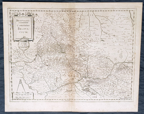
1628 Gerard Mercator & Henricus Hondius Antique Map of Beauvais Region, France
- Title : Beauvaisis Comitatus Belovacium
- Size: 21in x 17in (530mm x 430mm)
- Condition: (A) Very Good Condition
- Date : 1628
- Ref #: 26136
Description:
This original copper plate engraved antique map of the Beauvais region of Northern France - centering on the city of Beauvais & the Oise River running through the cities of Noyon, Compiègne, Creil by Gerard Mercator was published by Henricus Hondius in the early 1628 French edition of Gerard Mercators Atlas.
These maps, published in the early editions of Mercators atlas, are the original maps drawn and engraved by Gerald Mercator in the mid to late 16th century, published by his son Rumold as an atlas, after his death, in 1595. After two editions the plates were purchased by Jodocus Hondius in 1604, and continued to be published until the end of the 1630s by Henricus Hondius, when some of the plates were re-engraved and updated with the help of Jan Jansson.
General Definitions:
Paper thickness and quality: - Heavy and stable
Paper color : - off white
Age of map color: -
Colors used: -
General color appearance: -
Paper size: - 21in x 17in (530mm x 430mm)
Plate size: - 18 1/2in x 14in (475mm x 350mm)
Margins: - Min 1/2in (12mm)
Imperfections:
Margins: - Light age toning
Plate area: - Light toning along centerfold
Verso: - Light age toning
Background:
Beauvais is a city and commune in northern France. It serves as the capital of the Oise département, in the Hauts-de-France region. Beauvais is located approximately 75 kilometres from Paris.
Beauvais was known to the Romans by the Gallo-Roman name of Caesaromagus (magos is Common Celtic for field). The post-Renaissance Latin rendering is Bellovacum from the Belgic tribe the Bellovaci, whose capital it was. In the ninth century it became a countship, which about 1013 passed to the bishops of Beauvais, who became peers of France from the twelfth century. At the coronations of kings the Bishop of Beauvais wore the royal mantle and went, with the Bishop of Langres, to raise the king from his throne to present him to the people.
De Bello Gallico II 13 reports that as Julius Caesar was approaching a fortified town called Bratuspantium in the land of the Bellovaci, its inhabitants surrendered to him when he was about 5 Roman miles away. Its name is Gaulish for place where judgements are made, from *bratu-spantion. Some say that Bratuspantium is Beauvais. Others theorize that it is Vendeuil-Caply or Bailleul sur Thérain.
From 1004 to 1037, the Count of Beauvais was Odo II, Count of Blois.
In a charter dated 1056/1060, Eudo of Brittany granted land in pago Belvacensi (Beauvais, Picardy) to the Abbey of Angers Saint-Aubin
In 1346 the town had to defend itself against the English, who again besieged it in 1433. The siege which it endured in 1472 at the hands of the Duke of Burgundy, was rendered famous by the heroism of the towns women, under the leadership of Jeanne Hachette, whose memory is still celebrated by a procession on 27 June (the feast of Sainte Angadrême), during which women take precedence over men.
An interesting hoard of coins from the High Middle Ages became known as the Beauvais Hoard, because some of the British and European coins found with the lot were from the French abbey located in Beauvais. The hoard, which contained a variety of rare and extremely rare Anglo-Norman pennies, English and foreign coins, was reputed to have been found in or near Paris.
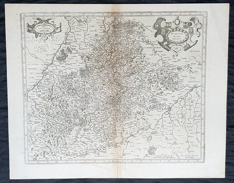
1628 Gerard Mercator & Henricus Hondius Antique Map of Duchy Wurttemberg Germany
- Title : Wirtenberg Ducatus...Per Geradum Mercatorem Cum Privilego
- Size: 21in x 17in (530mm x 430mm)
- Condition: (A+) Fine Condition
- Date : 1628
- Ref #: 26116
Description:
This original copper plate engraved antique map of Wurttemberg in todays Baden-Württemberg state in southern Germany, by Gerard Mercator was published by Henricus Hondius in the early 1628 French edition of Gerard Mercators Atlas.
These maps, published in the early editions of Mercators atlas, are the original maps drawn and engraved by Gerald Mercator in the mid to late 16th century, published by his son Rumold as an atlas, after his death, in 1595. After two editions the plates were purchased by Jodocus Hondius in 1604 and continued to be published until the mid 1630\'s when the plates were re-engraved and updated by Jan Jansson and Henricus Hondius.
General Definitions:
Paper thickness and quality: - Heavy and stable
Paper color : - off white
Age of map color: -
Colors used: -
General color appearance: -
Paper size: - 21in x 17in (530mm x 430mm)
Plate size: - 18 1/2in x 14in (475mm x 350mm)
Margins: - Min 1/2in (12mm)
Imperfections:
Margins: - Light age toning
Plate area: - Light toning along centerfold
Verso: - Light age toning
Background:
Württemberg is a historical German territory roughly corresponding to the cultural and linguistic region of Swabia. Together with Baden and Hohenzollern, two other historical territories, it now forms the Federal State of Baden-Württemberg. Württemberg was formerly also spelled Würtemberg and Wirtemberg.
The Duchy of Württemberg was a duchy located in the south-western part of the Holy Roman Empire. It was a member of the Holy Roman Empire from 1495 to 1806. The dukedoms long survival for nearly four centuries was mainly due to its size, being larger than its immediate neighbors. During the Protestant Reformation, Württemberg faced great pressure from the Holy Roman Empire to remain a member. Württemberg resisted repeated French invasions in the 17th and 18th centuries. Württemberg was directly in the path of French and Austrian armies who were engaged in the long rivalry between the House of Bourbon and the House of Habsburg. In 1803, Napoleon raised the duchy to be the Electorate of Württemberg of the Holy Roman Empire. On 1 January 1806, the last Elector assumed the title of King of Württemberg. Later this year, on 6 August 1806, the last Emperor, Francis II, abolished (de facto) the Holy Roman Empire.
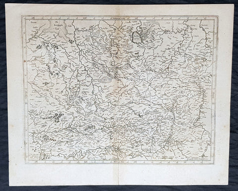
1628 Gerard Mercator & Henricus Hondius Antique Map of Westphalia, Germany
- Title : Tabula Seconde Westphalia...Per Geradum Mercatorem Cum Privilego...1627
- Size: 21in x 17in (530mm x 430mm)
- Condition: (A) Very Good Condition
- Date : 1628
- Ref #: 26109
Description:
This original copper plate engraved antique map of the Westphalia region of North Rhine-Westphalia, Germany, by Gerard Mercator was published by Henricus Hondius in the early 1628 French edition of Gerard Mercators Atlas.
These maps, published in the early editions of Mercators atlas, are the original maps drawn and engraved by Gerald Mercator in the mid to late 16th century, published by his son Rumold as an atlas, after his death, in 1595. After two editions the plates were purchased by Jodocus Hondius in 1604 and continued to be published until the mid 1630s by Henricus, when some of the plates were re-engraved and updated by Jan Jansson and Henricus Hondius.
General Definitions:
Paper thickness and quality: - Heavy and stable
Paper color : - off white
Age of map color: -
Colors used: -
General color appearance: -
Paper size: - 21in x 17in (530mm x 430mm)
Plate size: - 18 1/2in x 14in (475mm x 350mm)
Margins: - Min 1/2in (12mm)
Imperfections:
Margins: - Light age toning
Plate area: - Light toning along centerfold
Verso: - Light age toning
Background:
While the Northern Rhineland, Westphalia and Lippe are different historic territories of todays North Rhine-Westphalia, the old border between the former Rhine Province and the Province of Westphalia is also a language border. While in Westphalia and Lippe, people tend to speak West Low German dialects and especially the Westphalian variant of the Low German language, Central German and Low Franconian dialects are being spoken in the Northern Rhineland.
Westphalia is known for the 1648 Peace of Westphalia which ended the Thirty Years War, as the two treaties were signed in Münster and Osnabrück.
It is one of the regions that were part of all incarnations of the German state since the Early Middle Ages: the Holy Roman Empire, the Confederation of the Rhine, the German Confederation, the North German Confederation, the German Empire, the Weimar Republic and National Socialist Germany. After World War II it was a part of the British occupation zone which merged with the American zone to become the Bizone in 1947 and again merged with the French zone to become the Trizone in 1948. The current Federal Republic of Germany was founded on these territories making Westphalia a part of West Germany. It is a part of united Germany since 1990.
1628 Gerard Mercator & Henricus Hondius Antique Map State of Hesse, Germany
- Title : Hassia landtgrauiatus...Per Geradum Mercatorem Cum Privilego
- Size: 21in x 17in (530mm x 430mm)
- Condition: (A) Very Good Condition
- Date : 1628
- Ref #: 26107
Description:
This original copper plate engraved antique map of the State of Hesse or Hessia, in central Germany, by Gerard Mercator was published by Henricus Hondius in the early 1628 French edition of Gerard Mercators Atlas.
These maps, published in the early editions of Mercators atlas, are the original maps drawn and engraved by Gerald Mercator in the mid to late 16th century, published by his son Rumold as an atlas, after his death, in 1595. After two editions the plates were purchased by Jodocus Hondius in 1604 and continued to be published until the mid 1630s by Henricus, when some of the plates were re-engraved and updated by Jan Jansson and Henricus Hondius.
General Definitions:
Paper thickness and quality: - Heavy and stable
Paper color : - off white
Age of map color: -
Colors used: -
General color appearance: -
Paper size: - 21in x 17in (530mm x 430mm)
Plate size: - 18 1/2in x 14in (475mm x 350mm)
Margins: - Min 1/2in (12mm)
Imperfections:
Margins: - Light age toning
Plate area: - Light toning along centerfold
Verso: - Light age toning
Background:
Hesse officially the State of Hesse, is a federal state (Land) of the Federal Republic of Germany, with just over six million inhabitants. The state capital is Wiesbaden; the largest city is Frankfurt am Main.
In the 12th century, Hessengau was passed to Thuringia. In the War of the Thuringian Succession (1247–1264), Hesse gained independence and became a Landgraviate within the Holy Roman Empire. It shortly rose to primary importance under Landgrave Philip the Magnanimous, who was one of the leaders of German Protestantism. After Philips death in 1567, the territory was divided among his four sons from his first marriage (Philip was a bigamist) into four lines: Hesse-Kassel (or Hesse-Cassel), Hesse-Darmstadt, Hesse-Rheinfels, and the also previously existing Hesse-Marburg. As the latter two lines died out quite soon (1583 and 1605, respectively), Hesse-Kassel and Hesse-Darmstadt were the two core states within the Hessian lands. Several collateral lines split off during the centuries, such as in 1622, when Hesse-Homburg split off from Hesse-Darmstadt. In the late 16th century, Kassel adopted Calvinism, while Darmstadt remained Lutheran and subsequently the two lines often found themselves on different sides of a conflict, most notably in the disputes over Hesse-Marburg and in the Thirty Years War, when Darmstadt fought on the side of the Emperor, while Kassel sided with Sweden and France.
The Landgrave Frederick II (1720–1785) ruled as a benevolent despot, from 1760 to 1785. He combined Enlightenment ideas with Christian values, cameralist plans for central control of the economy, and a militaristic approach toward diplomacy.[16] He funded the depleted treasury of the poor nation by loaning 19,000 soldiers in complete military formations to Great Britain to fight in North America during the American Revolutionary War, 1776–1783. These soldiers, commonly known as Hessians, fought under the British flag. The British used the Hessians in several conflicts, including in the Irish Rebellion of 1798. For further revenue, the soldiers were loaned to other places as well. Most were conscripted, with their pay going to the Landgrave.
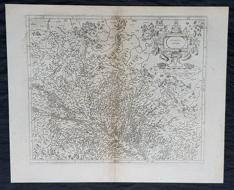
1628 Gerard Mercator & Henricus Hondius Antique Map the Alsace Region of France
- Title : Alsatia inferior..Per Gerardam Mercatorem Cum privilegio
- Size: 21in x 17in (530mm x 430mm)
- Condition: (A) Very Good Condition
- Date : 1628
- Ref #: 26113
Description:
This original copper plate engraved antique map of the French region of Alsace by Gerard Mercator was published by Henricus Hondius in the early 1628 French edition of Gerard Mercators Atlas.
These maps, published in the early editions of Mercators atlas, are the original maps drawn and engraved by Gerald Mercator in the mid to late 16th century, published by his son Rumold as an atlas, after his death, in 1595. After two editions the plates were purchased by Jodocus Hondius in 1604, and continued to be published until the end of the 1630s by Henricus Hondius, when some of the plates were re-engraved and updated with the help of Jan Jansson.
General Definitions:
Paper thickness and quality: - Heavy and stable
Paper color : - off white
Age of map color: -
Colors used: -
General color appearance: -
Paper size: - 21in x 17in (530mm x 430mm)
Plate size: - 18 1/2in x 14in (475mm x 350mm)
Margins: - Min 1/2in (12mm)
Imperfections:
Margins: - Light age toning
Plate area: - Light toning along centerfold
Verso: - Light age toning
Background:
Alsace is a cultural and historical region in eastern France, on the west bank of the upper Rhine next to Germany and Switzerland.
As in much of Europe, the prosperity of Alsace came to an end in the 14th century by a series of harsh winters, bad harvests, and the Black Death. These hardships were blamed on Jews, leading to the pogroms of 1336 and 1339. In 1349, Jews of Alsace were accused of poisoning the wells with plague, leading to the massacre of thousands of Jews during the Strasbourg pogrom. Jews were subsequently forbidden to settle in the town. An additional natural disaster was the Rhine rift earthquake of 1356, one of Europes worst which made ruins of Basel. Prosperity returned to Alsace under Habsburg administration during the Renaissance.
Holy Roman Empire central power had begun to decline following years of imperial adventures in Italian lands, often ceding hegemony in Western Europe to France, which had long since centralized power. France began an aggressive policy of expanding eastward, first to the rivers Rhône and Meuse, and when those borders were reached, aiming for the Rhine. In 1299, the French proposed a marriage alliance between Philip IV of Frances sister Blanche and Albert I of Germanys son Rudolf, with Alsace to be the dowry; however, the deal never came off. In 1307, the town of Belfort was first chartered by the Counts of Montbéliard. During the next century, France was to be militarily shattered by the Hundred Years War, which prevented for a time any further tendencies in this direction. After the conclusion of the war, France was again free to pursue its desire to reach the Rhine and in 1444 a French army appeared in Lorraine and Alsace. It took up winter quarters, demanded the submission of Metz and Strasbourg and launched an attack on Basel.
In 1469, following the Treaty of St. Omer [fr], Upper Alsace was sold by Archduke Sigismund of Austria to Charles the Bold, Duke of Burgundy. Although Charles was the nominal landlord, taxes were paid to Frederick III, Holy Roman Emperor. The latter was able to use this tax and a dynastic marriage to his advantage to gain back full control of Upper Alsace (apart from the free towns, but including Belfort) in 1477 when it became part of the demesne of the Habsburg family, who were also rulers of the empire. The town of Mulhouse joined the Swiss Confederation in 1515, where it was to remain until 1798.
By the time of the Protestant Reformation in the 16th century, Strasbourg was a prosperous community, and its inhabitants accepted Protestantism in 1523. Martin Bucer was a prominent Protestant reformer in the region. His efforts were countered by the Roman Catholic Habsburgs who tried to eradicate heresy in Upper Alsace. As a result, Alsace was transformed into a mosaic of Catholic and Protestant territories. On the other hand, Mömpelgard (Montbéliard) to the southwest of Alsace, belonging to the Counts of Württemberg since 1397, remained a Protestant enclave in France until 1793.
This situation prevailed until 1639, when most of Alsace was conquered by France to keep it out of the hands of the Spanish Habsburgs, who by secret treaty in 1617 had gained a clear road to their valuable and rebellious possessions in the Spanish Netherlands, the Spanish Road. Beset by enemies and seeking to gain a free hand in Hungary, the Habsburgs sold their Sundgau territory (mostly in Upper Alsace) to France in 1646, which had occupied it, for the sum of 1.2 million Thalers. When hostilities were concluded in 1648 with the Treaty of Westphalia, most of Alsace was recognized as part of France, although some towns remained independent. The treaty stipulations regarding Alsace were complex. Although the French king gained sovereignty, existing rights and customs of the inhabitants were largely preserved. France continued to maintain its customs border along the Vosges mountains where it had been, leaving Alsace more economically oriented to neighbouring German-speaking lands. The German language remained in use in local administration, in schools, and at the (Lutheran) University of Strasbourg, which continued to draw students from other German-speaking lands. The 1685 Edict of Fontainebleau, by which the French king ordered the suppression of French Protestantism, was not applied in Alsace. France did endeavour to promote Catholicism. Strasbourg Cathedral, for example, which had been Lutheran from 1524 to 1681, was returned to the Catholic Church. However, compared to the rest of France, Alsace enjoyed a climate of religious tolerance.
France consolidated its hold with the 1679 Treaties of Nijmegen, which brought most remaining towns under its control. France seized Strasbourg in 1681 in an unprovoked action. These territorial changes were recognised in the 1697 Treaty of Ryswick that ended the War of the Grand Alliance.
The year 1789 brought the French Revolution and with it the first division of Alsace into the départements of Haut- and Bas-Rhin. Alsatians played an active role in the French Revolution. On 21 July 1789, after receiving news of the Storming of the Bastille in Paris, a crowd of people stormed the Strasbourg city hall, forcing the city administrators to flee and putting symbolically an end to the feudal system in Alsace. In 1792, Rouget de Lisle composed in Strasbourg the Revolutionary marching song La Marseillaise (as Marching song for the Army of the Rhine), which later became the anthem of France. La Marseillaise was played for the first time in April of that year in front of the mayor of Strasbourg Philippe-Frédéric de Dietrich. Some of the most famous generals of the French Revolution also came from Alsace, notably Kellermann, the victor of Valmy, Kléber, who led the armies of the French Republic in Vendée and Westermann, who also fought in the Vendée.
At the same time, some Alsatians were in opposition to the Jacobins and sympathetic to the restoration of the monarchy pursued by the invading forces of Austria and Prussia who sought to crush the nascent revolutionary republic. Many of the residents of the Sundgau made pilgrimages to places like Mariastein Abbey, near Basel, in Switzerland, for baptisms and weddings. When the French Revolutionary Army of the Rhine was victorious, tens of thousands fled east before it. When they were later permitted to return (in some cases not until 1799), it was often to find that their lands and homes had been confiscated. These conditions led to emigration by hundreds of families to newly vacant lands in the Russian Empire in 1803–4 and again in 1808. A poignant retelling of this event based on what Goethe had personally witnessed can be found in his long poem Hermann and Dorothea.
In response to the hundred day restoration of Napoleon I of France in 1815, Alsace along with other frontier provinces of France was occupied by foreign forces from 1815 to 1818, including over 280,000 soldiers and 90,000 horses in Bas-Rhin alone. This had grave effects on trade and the economy of the region since former overland trade routes were switched to newly opened Mediterranean and Atlantic seaports.
The population grew rapidly, from 800,000 in 1814 to 914,000 in 1830 and 1,067,000 in 1846. The combination of economic and demographic factors led to hunger, housing shortages and a lack of work for young people. Thus, it is not surprising that people left Alsace, not only for Paris – where the Alsatian community grew in numbers, with famous members such as Baron Haussmann – but also for more distant places like Russia and the Austrian Empire, to take advantage of the new opportunities offered there: Austria had conquered lands in Eastern Europe from the Ottoman Empire and offered generous terms to colonists as a way of consolidating its hold on the new territories. Many Alsatians also began to sail to the United States, settling in many areas from 1820 to 1850. In 1843 and 1844, sailing ships bringing immigrant families from Alsace arrived at the port of New York. Some settled in Texas and Illinois, many to farm or to seek success in commercial ventures: for example, the sailing ships Sully (in May 1843) and Iowa (in June 1844) brought families who set up homes in northern Illinois and northern Indiana. Some Alsatian immigrants were noted for their roles in 19th-century American economic development. Others ventured to Canada to settle in southwestern Ontario, notably Waterloo County.
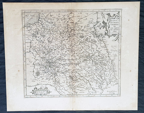
1628 Gerard Mercator & Henricus Hondius Antique Map the Picardy Region of France
- Title : France Picardie Champagne cum regionibus adiacentibus
- Size: 21in x 17in (530mm x 430mm)
- Condition: (A) Very Good Condition
- Date : 1628
- Ref #: 26131
Description:
This original copper plate engraved antique map of the French region of Picardy or Picardie by Gerard Mercator was published by Henricus Hondius in the early 1628 French edition of Gerard Mercators Atlas.
These maps, published in the early editions of Mercators atlas, are the original maps drawn and engraved by Gerald Mercator in the mid to late 16th century, published by his son Rumold as an atlas, after his death, in 1595. After two editions the plates were purchased by Jodocus Hondius in 1604, and continued to be published until the end of the 1630s by Henricus Hondius, when some of the plates were re-engraved and updated with the help of Jan Jansson.
General Definitions:
Paper thickness and quality: - Heavy and stable
Paper color : - off white
Age of map color: -
Colors used: -
General color appearance: -
Paper size: - 21in x 17in (530mm x 430mm)
Plate size: - 18 1/2in x 14in (475mm x 350mm)
Margins: - Min 1/2in (12mm)
Imperfections:
Margins: - Light age toning
Plate area: - Light toning along centerfold
Verso: - Light age toning
Background:
Picardy is a historical territory and a former administrative region of Northern France and now part of the new region Nord-Pas-de-Calais-Picardie.
From the 5th century the area was part of the Frankish Empire, and in the feudal period it encompassed the six countships of Boulogne, Montreuil, Ponthieu, Amiénois,Vermandois, and Laonnois. According to the 843 Treaty of Verdun the region became part of West Francia, the later Kingdom of France.
The name Picardy (which may have referred to a Frankish tribe of picards or pike-bearers) was not used until the 12th or 13th century. During this time, the name applied to all lands where the Picard language was spoken, which included all the territories from Paris to the Netherlands. In the Latin Quarter of Paris, people identified a Picard Nation (Nation Picarde) of students at Sorbonne University, most of whom actually came from Flanders. During the Hundred Years\\\' War, Picardy was the centre of the Jacquerie peasant revolt in 1358.
From 1419 onwards, the Picardy counties (Boulogne, Ponthieu, Amiens, Vermandois) were gradually acquired by the Burgundian duke Philip the Good, confirmed by King Charles VII of France at the 1435 Congress of Arras. In 1477, King Louis XI of France led an army and occupied key towns in Picardy. By the end of 1477, Louis would control all of Picardy and most of Artois.
In the 16th century, the government (military region) of Picardy was created. This became a new administrative region of France, separate from what was historically defined as Picardy. The new Picardy included the Somme département, the northern half of the Aisne département, and a small fringe in the north of the Oise département.
In 1557, Picardy was invaded by Hapbsburg forces under the command of Emmanuel Philibert, Duke of Savoy. After a seventeen-day siege, St. Quentin would be ransacked while Noyon would be burned by the Habsburg army.
In the 17th century, an infectious disease similar to English sweat originated from the region and spread across France. It was called Suette des picards or Picardy sweat.
Sugar beet was introduced by Napoleon I during the Napoleonic Wars in the 19th century, in order to counter the United Kingdom, which had seized the sugar islands possessed by France in the Caribbean. The sugar industry has continued to play a prominent role in the economy of the region.
One of the most significant historical events to occur in Picardy was the series of battles fought along the Somme during World War I. From September 1914 to August 1918, four major battles, including the Battle of the Somme, were fought by British, French, and German forces in the fields of Northern Picardy. (Ref: Koeman; M&B; Tooley)
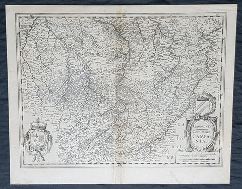
1628 Gerard Mercator & Henricus Hondius Antique Map, Champagne Region of France
- Title : Champagne...Comitatus Campania
- Size: 21in x 17in (530mm x 430mm)
- Condition: (A) Very Good Condition
- Date : 1628
- Ref #: 26134
Description:
This original copper plate engraved antique map of the French region of Champagne by Gerard Mercator was published by Henricus Hondius in the early 1628 French edition of Gerard Mercators Atlas.
These maps, published in the early editions of Mercators atlas, are the original maps drawn and engraved by Gerald Mercator in the mid to late 16th century, published by his son Rumold as an atlas, after his death, in 1595. After two editions the plates were purchased by Jodocus Hondius in 1604, and continued to be published until the end of the 1630s by Henricus Hondius, when some of the plates were re-engraved and updated with the help of Jan Jansson.
General Definitions:
Paper thickness and quality: - Heavy and stable
Paper color : - off white
Age of map color: -
Colors used: -
General color appearance: -
Paper size: - 21in x 17in (530mm x 430mm)
Plate size: - 18 1/2in x 14in (475mm x 350mm)
Margins: - Min 1/2in (12mm)
Imperfections:
Margins: - Light age toning
Plate area: - Light toning along centerfold
Verso: - Light age toning
1628 Gerard Mercator & Henricus Hondius Antique Map, Champagne Region of France
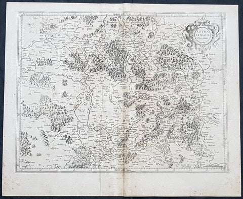
1628 Gerard Mercator Antique Map Lotharingia Region - Netherlands Germany France
- Title : Lotharingia Ducatus...Per Geradum Mercatorem Cum Privilegio
- Size: 21in x 17in (530mm x 430mm)
- Condition: (A) Very Good Condition
- Date : 1628
- Ref #: 26141
Description:
This original copper plate engraved antique map of the historical region of Lotharingia region of present-day Netherlands, Belgium, Luxembourg, North Rhine-Westphalia (Germany), Rhineland-Palatinate (Germany), Saarland (Germany), and Lorraine (France) by Gerard Mercator was published by Henricus Hondius in the early 1628 French edition of Gerard Mercators Atlas.
These maps, published in the early editions of Mercators atlas, are the original maps drawn and engraved by Gerald Mercator in the mid to late 16th century, published by his son Rumold as an atlas, after his death, in 1595. After two editions the plates were purchased by Jodocus Hondius in 1604 and continued to be published until the mid 1630\\\'s when the plates were re-engraved and updated by Jan Jansson and Henricus Hondius.
General Definitions:
Paper thickness and quality: - Heavy and stable
Paper color : - off white
Age of map color: -
Colors used: -
General color appearance: -
Paper size: - 21in x 17in (530mm x 430mm)
Plate size: - 20in x 15in (510mm x 380mm)
Margins: - Min 1/2in (12mm)
Imperfections:
Margins: - Age toning
Plate area: - Age toning
Verso: - Age toning
Lotharingia was a medieval successor kingdom of the Carolingian Empire, comprising the present-day Netherlands, Belgium, Luxembourg, North Rhine-Westphalia (Germany), Rhineland-Palatinate (Germany), Saarland (Germany), and Lorraine (France). It was named after King Lothair II who received this territory after the kingdom of Middle Francia of his father Lothair I was divided among his sons in 855.
Lotharingia was born out of the tripartite division in 855 of the kingdom of Middle Francia, which itself was formed after the threefold division of the Carolingian Empire by the Treaty of Verdun of 843. Conflict between East and West Francia over Lotharingia was based on the fact that these were the old Frankish homelands of Austrasia, so possession of them was of great prestige.
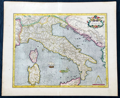
1628 Gerard Mercator Antique Map of Italy, Italia - Beautiful 1st Ed.
Antique Map
- Title : Italia
- Ref #: 35627
- Condition: (A+) Fine Condition
- Size: 22 1/2in x 18 1/2in (615mm x 470mm)
- Date: 1628
- Price: $1050.00US
Description:
This original beautifully hand coloured copper plate engraved antique map of Italy by Gerard Mercator, his first map of Italy for Atlas, was published in the 1628 Latin edition of Mercators Atlas Atlas Sive Cosmographicae Meditationes De Fabrica Mundi
This is a beautiful map with original hand colouring, heavy age toned paper with a deep impression. Beautiful map.
General Definitions:
Paper thickness and quality: - Heavy and stable
Paper color : - Off white
Age of map color: - Original
Colors used: - Yellow, green, blue, pink
General color appearance: - Authentic
Paper size: - 22 1/2in x 18 1/2in (615mm x 470mm)
Plate size: - 18 1/2in x 15in (470mm x 385mm)
Margins: - Min 1/2in (12mm)
Imperfections:
Margins: - None
Plate area: - Crease along centerfold
Verso: - None
Background:
Since classical times the countries bordering the enclosed waters of the Mediterranean had been well versed in the use of maps and sea charts and in Italy, more than anywhere else, the traditional knowledge was kept alive during the many hundreds of years following the collapse of the Roman Empire. By the thirteenth and fourteenth centuries the seamen of Venice, Genoa and Amalfi traded to far countries, from the Black Sea ports and the coasts of Palestine and Egypt in the East to Flanders and the southern coasts of England and Ireland in the West, their voyages guided by portulan charts and the use of the newly invented compass. For a time Italian supremacy in cartography passed to Aragon and the Catalan map makers based on Majorca, but by the year 1400 the power and wealth of the city states of Venice, Genoa, Florence and Milan surpassed any in Europe. Florence, especially, under the rule of the Medici family, became not only a great trading and financial centre but also the focal point of the rediscovery of the arts and learning of the ancient world. In this milieu a number of manuscript world maps were produced, of which one by Fra Mauro (c. 1459) is the most notable, but the event of the greatest importance in the history of cartography occurred in the year 1400 when a Florentine, Palla Strozzi, brought from Constantinople a Greek manuscript copy of Claudius Ptolemy's Geographia, which, 1,250 years after its compilation, came as a revelation to scholars in Western Europe. In the following fifty years or so manuscript copies, translated into Latin and other languages, became available in limited numbers but the invention of movable-type printing transformed the scene: the first copy without maps being printed in 1475 followed by many with copper-engraved maps, at Bologna in 1477, Rome 1478, 1490, 1507 and 1508, and Florence 1482.
About the year 1485 the first book of sea charts, compiled by Bartolommeo dalli Sonetti, was printed in Venice and in the first part of the sixteenth century a number of world maps were published, among them one compiled in 1506 by Giovanni Contarini, engraved by Francesco Rosselli, which was the first printed map to show the discoveries in the New World. In the following years there were many attractive and unusual maps of Islands (Isolano) by Bordone, Camocio and Porcacchi, but more important was the work of Giacomo (Jacopo) Gastaldi, a native of Piedmont who started life as an engineer in the service of the Venetian Republic before turning to cartography as a profession. His maps, produced in great variety and quantity, were beautifully drawn copperplate engravings and his style and techniques were widely copied by his contemporaries. From about 1550 to 1580 many of Gastaldi's maps appeared in the collections of maps known as Lafreri 'atlases', a term applied to groups of maps by different cartographers brought together in one binding. As the contents of such collections varied considerably they were no doubt assembled at the special request of wealthy patrons and are now very rare indeed.
About this time, for a variety of historical and commercial reasons, Italy's position as the leading trading and financial nation rapidly declined and with it her superiority in cartography was lost to the vigorous new states in the Low Countries. That is not to say, of course, that Italian skills as map makers were lost entirely for it was not until 1620 that the first printed maps of Italy by an Italian, Giovanni Magini, appeared, and much later in the century there were fine maps by Giacomo de Rossi and Vincenzo Coronelli, the latter leading a revival of interest in cartography at the end of the century. Coronelli was also famous for the construction of magnificent large-size globes and for the foundation in Venice in 1680 of the first geographical society.
In the eighteenth century the best-known names are Antonio Zatta, Rizzi-Zannoni and Giovanni Cassini.
We ought to mention the work of Baptista Boazio who drew a series of maps in A Summarie and True Discourse of Sir Francis Drake's West Indian Voyage, published in 1588-89, and who is especially noted for a very fine map of Ireland printed in 1599 which was incorporated in the later editions of the Ortelius atlases. It is perhaps appropriate also to refer to two English map makers who spent many years in exile in Italy: the first, George Lily, famous for the splendid map of the British Isles issued in Rome in 1546, and the second, Robert Dudley, who exactly one hundred years later was responsible for the finest sea atlas of the day, Dell' Arcano del Mare, published in Florence. Both of these are described in greater detail elsewhere in this handbook. (Ref: Tooley, Koeman)
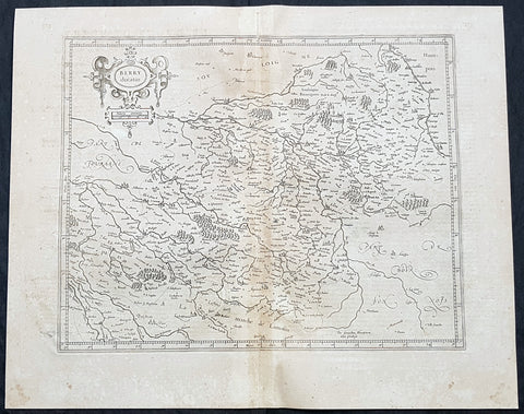
1628 Gerard Mercator Antique Map of the Berry Province of central France
- Title : Berry Ducatus...Per Geradum Mercatorem Cum Privilegio
- Size: 21in x 17in (530mm x 430mm)
- Condition: (A) Very Good Condition
- Date : 1628
- Ref #: 26137
Description:
This original copper plate engraved antique map of the Berry Province of central France by Gerard Mercator was published by Henricus Hondius in the early 1628 French edition of Gerard Mercators Atlas.
These maps, published in the early editions of Mercators atlas, are the original maps drawn and engraved by Gerald Mercator in the mid to late 16th century, published by his son Rumold as an atlas, after his death, in 1595. After two editions the plates were purchased by Jodocus Hondius in 1604 and continued to be published until the mid 1630\\\'s when the plates were re-engraved and updated by Jan Jansson and Henricus Hondius.
General Definitions:
Paper thickness and quality: - Heavy and stable
Paper color : - off white
Age of map color: -
Colors used: -
General color appearance: -
Paper size: - 21in x 17in (530mm x 430mm)
Plate size: - 20in x 15in (510mm x 380mm)
Margins: - Min 1/2in (12mm)
Imperfections:
Margins: - Age toning
Plate area: - Age toning
Verso: - Age toning
Berry is a region located in the center of France. It was a province of France until départements replaced the provinces on 4 March 1790, when Berry became divided between the départements of Cher (High Berry) and Indre (Low Berry).
The Berry region now consists of the départements of Cher, Indre and parts of Creuse. The city Bourges functioned as the capital of Berry. Berry is notable as the birthplace of several kings and other members of the French royal family, and was the birthplace of the famous knight Baldwin Chauderon, who fought in the First Crusade. In the Middle Ages, Berry became the centre of the Duchy of Berry. It is also known for an illuminated manuscript produced in the 14th–15th century called Les Très Riches Heures du Duc de Berry.
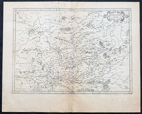
1628 Gerard Mercator Antique Map of The Burgundy Region of France
- Title : Burgundia Ducatus
- Size: 21in x 17in (530mm x 430mm)
- Condition: (A) Very Good Condition
- Date : 1628
- Ref #: 26143
Description:
This original copper plate engraved antique map of of the historical region of the Free County of Burgundy (Franche Comte de Bourgogne) of eastern France by Gerard Mercator was published by Henricus Hondius in the early 1628 French edition of Gerard Mercators Atlas.
These maps, published in the early editions of Mercators atlas, are the original maps drawn and engraved by Gerald Mercator in the mid to late 16th century, published by his son Rumold as an atlas, after his death, in 1595. After two editions the plates were purchased by Jodocus Hondius in 1604 and continued to be published until the mid 1630\\\'s when the plates were re-engraved and updated by Jan Jansson and Henricus Hondius.
General Definitions:
Paper thickness and quality: - Heavy and stable
Paper color : - off white
Age of map color: -
Colors used: -
General color appearance: -
Paper size: - 21in x 17in (530mm x 430mm)
Plate size: - 20in x 15in (510mm x 380mm)
Margins: - Min 1/2in (12mm)
Imperfections:
Margins: - Age toning, light creasing
Plate area: - Age toning, light creasing
Verso: - Age toning, light creasing
Background:
Burgundy is a historical territory and a former administrative region of France. It takes its name from the Burgundians, an East Germanic people who moved westwards beyond the Rhine during the late Roman period.
Historically, Burgundy has referred to numerous political entities, including kingdoms and duchies spanning territory from the Mediterranean to the Low Countries.
The first recorded inhabitants of the area that became Burgundy were Celts, who were eventually incorporated in the Roman Empire as Gallo-Romans.
During the 4th century, the Burgundians, a Germanic people, who may have originated in Bornholm (on the Baltic Sea), settled in the western Alps. They founded the Kingdom of the Burgundians, which was conquered in the 6th century by another Germanic tribe, the Franks.
Later, the region was divided between the Duchy of Burgundy (to the west) and the Free County of Burgundy (to the east). The Duchy of Burgundy is the better-known of the two, later becoming the French province of Burgundy, while the County of Burgundy became the French province of Franche-Comté, literally meaning free county.
Burgundys modern existence is rooted in the dissolution of the Frankish Empire. In the 880s, there were four Burgundies, which were the Kingdom of Upper and Lower Burgundy, the duchy and the county.
During the Middle Ages, Burgundy was home to some of the most important Western churches and monasteries, including those of Cluny, Cîteaux, and Vézelay. Cluny, founded in 910, exerted a strong influence in Europe for centuries. The first Cistercian abbey was founded in 1098 in Cîteaux. Over the next century, hundreds of Cistercian abbeys were founded throughout Europe, in a large part due to the charisma and influence of Bernard of Clairvaux. The Abbey of Fontenay, a UNESCO World Heritage site, is today the best-preserved Cistercian abbey in Burgundy. The Abbey of Vezelay, also a UNESCO site, is still a starting point for pilgrimages to Santiago de Compostela. Cluny was almost totally destroyed during the French Revolution.
During the Hundred Years War, King John II of France gave the duchy to his youngest son, Philip the Bold. The duchy soon became a major rival to the crown. The court in Dijon outshone the French court both economically and culturally. In 1477, at the battle of Nancy during the Burgundian Wars, the last duke Charles the Bold was killed in battle, and the Duchy itself was annexed by France and became a province. However the northern part of the empire was taken by the Austrian Habsburgs.
With the French Revolution in the end of the 18th century, the administrative units of the provinces disappeared, but were reconstituted as regions during the Fifth Republic in the 1970s. The modern-day administrative region comprises most of the former duchy.
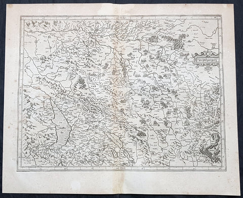
1628 Gerard Mercator Antique Map the Franche Comte de Bourgogne Region of France
- Title : La Haute Bourgoigne...Per Geradum Mercatorem Cum Privilegio
- Size: 21in x 17in (530mm x 430mm)
- Condition: (A) Very Good Condition
- Date : 1628
- Ref #: 26144
Description:
This original copper plate engraved antique map of of the historical region of the Free County of Burgundy (Franche Comte de Bourgogne) of eastern France by Gerard Mercator was published by Henricus Hondius in the early 1628 French edition of Gerard Mercators Atlas.
These maps, published in the early editions of Mercators atlas, are the original maps drawn and engraved by Gerald Mercator in the mid to late 16th century, published by his son Rumold as an atlas, after his death, in 1595. After two editions the plates were purchased by Jodocus Hondius in 1604 and continued to be published until the mid 1630\\\'s when the plates were re-engraved and updated by Jan Jansson and Henricus Hondius.
General Definitions:
Paper thickness and quality: - Heavy and stable
Paper color : - off white
Age of map color: -
Colors used: -
General color appearance: -
Paper size: - 21in x 17in (530mm x 430mm)
Plate size: - 20in x 15in (510mm x 380mm)
Margins: - Min 1/2in (12mm)
Imperfections:
Margins: - Age toning
Plate area: - Age toning
Verso: - Age toning
Background:
The Free County of Burgundy (French: Franche Comté de Bourgogne; German: Freigrafschaft Burgund) was a medieval county (from 982 to 1678) of the Holy Roman Empire, within the modern region of Bourgogne-Franche-Comté, whose very name is still reminiscent of the title of its count: Freigraf (\\\'free count\\\', denoting imperial immediacy, or franc comte in French, hence the term franc(he) comté for his feudal principality). It should not be confused with the more westerly Duchy of Burgundy, a fiefdom of Francia since 843.
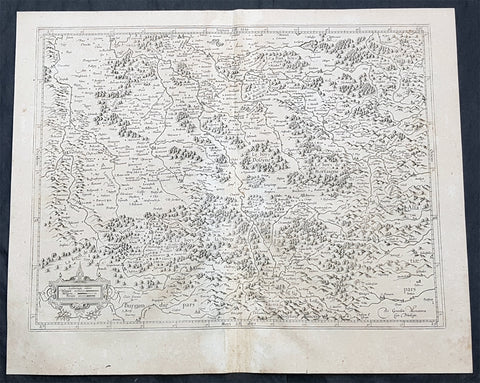
1628 Gerard Mercator Antique Map the Southern Lorraine Region of France
- Title : La Partie Meridionale de Lorraine...Per Geradum Mercatorem Cum Privilegio
- Size: 21in x 17in (530mm x 430mm)
- Condition: (A) Very Good Condition
- Date : 1628
- Ref #: 26142
Description:
This original copper plate engraved antique map ancient region of southern Lorraine, France by Gerard Mercator was published by Henricus Hondius in the early 1628 French edition of Gerard Mercators Atlas.
These maps, published in the early editions of Mercators atlas, are the original maps drawn and engraved by Gerald Mercator in the mid to late 16th century, published by his son Rumold as an atlas, after his death, in 1595. After two editions the plates were purchased by Jodocus Hondius in 1604 and continued to be published until the mid 1630\\\'s when the plates were re-engraved and updated by Jan Jansson and Henricus Hondius.
General Definitions:
Paper thickness and quality: - Heavy and stable
Paper color : - off white
Age of map color: -
Colors used: -
General color appearance: -
Paper size: - 21in x 17in (530mm x 430mm)
Plate size: - 20in x 15in (510mm x 380mm)
Margins: - Min 1/2in (12mm)
Imperfections:
Margins: - Age toning
Plate area: - Age toning
Verso: - Age toning
Lorraine is a cultural and historical region in north-eastern France, now located in the administrative region of Grand Est. Lorraines name stems from the medieval kingdom of Lotharingia, which in turn was named for either Emperor Lothair I or King Lothair II. It later was ruled as the Duchy of Lorraine before the Kingdom of France annexed it in 1766.
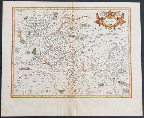
1628 Henricus Hondius Antique Map of the Duchy of Anjou, Maine-et-Loire, France
- Title : Aniov
- Date : 1628
- Size: 21in x 17in (535mm x 430mm)
- Ref #: 26135
- Condition: (A) Very Good Condition
Description:
This beautifully hand coloured original copper-plate engraved antique map of the French region of the historical province of Anjou (today a greater part of the Maine-et-Loire dept.) centering on the city of Angers & the Loire River was published in the 1628 French edition of Mercators Atlas by Henricus Hondius and Jan Jansson.
General Definitions:
Paper thickness and quality: - Heavy and stable
Paper color : - off white
Age of map color: - Original
Colors used: - Yellow, green, blue, pink
General color appearance: - Authentic
Paper size: - 21in x 17in (535mm x 430mm)
Plate size: - 18in x 14in (460mm x 360mm)
Margins: - Min 1/2in (12mm)
Imperfections:
Margins: - None
Plate area: - Age toning along centerfold
Verso: - Age toning along centerfold
Background:
Anjou is a historical province of France straddling the lower Loire River. Its capital was Angers and it was roughly coextensive with the diocese of Angers. It bordered Brittany to the west, Maine to the north, Touraine to the east and Poitou to the south. The adjectival form of Anjou is Angevin and inhabitants of Anjou are known as Angevins. During the Middle Ages, the county of Anjou was a prominent fief of the French crown.
The region takes its name from the Celtic tribe of the Andecavi, who submitted to Roman rule following the Gallic Wars. Under the Romans, the chief fortified settlement of the Andecavi became the city of Juliomagus, the future Angers. The territory of the Andecavi was organized as a civitas (called the civitas Andegavensis or civitas Andegavorum).
Under the Franks, the city of Juliomagus took the name of the ancient tribe and became Angers. Under the Merovingians, the history of Anjou is obscure. It is not recorded as a county (comitatus) until the time of the Carolingians. In the late ninth and early tenth centuries the viscounts (representatives of the counts) usurped comital authority and made Anjou an autonomous hereditary principality. The first dynasty of counts of Anjou, the House of Ingelger, ruled continuously down to 1205. In 1131, Count Fulk V became the King of Jerusalem; then in 1154, his grandson, Henry \'Curtmantle\' became King of England. The territories ruled by Henry and his successors, which stretched from Ireland to the Pyrenees, are often called the Angevin Empire. This empire was broken up by the French king Philip II, who confiscated the dynasty\'s French lands, including Anjou in 1205.
The county of Anjou was united to the royal domain between 1205 and 1246, when it was turned into an apanage for the king\'s brother, Charles I of Anjou. This second Angevin dynasty, a branch of the Capetian dynasty, established itself on the throne of Naples and Hungary. Anjou itself was united to the royal domain again in 1328, but was detached in 1360 as the Duchy of Anjou for the king\'s son, Louis I of Anjou. The third Angevin dynasty, a branch of the House of Valois, also ruled for a time the Kingdom of Naples. The dukes had the same autonomy as the earlier counts, but the duchy was increasingly administered in the same fashion as the royal domain and the royal government often exercised the ducal power while the dukes were away. When the Valois line failed and Anjou was incorporated into the royal domain again in 1480, there was little change on the ground. Anjou remained a province of crown until the French Revolution (1790), when the provinces were reorganized.

1633 Mercator Antique Map of America & The Great Southern Land - Terra Australis
- Title : America sive India Nova. ad magna Gerardi Mercatoris aui Universalis imitationem in compendium redacta. Per Michaelem Mercatorem Duysburgensem
- Ref #: 61017
- Size: 21 1/2in x 17 3/4in (545mm x 450mm)
- Date : 1633
- Condition: (A) Very Good Condition
Description:
This fine beautifully hand coloured original antique early map of America and the Great Southern Continent (Terra Australis) that was envisaged in the southern Hemisphere, prior to the discovery of Australia by Captain Cook in 1769 - the only map attributed to Gerard Mercator's Grandson Michael - was published in the 1633 French edition of Mercator's Atlas.
This map is magnificent with beautiful original hand colouring, wide margins and stable paper. Backed with transparent archival Japanese paper. Original colouring such as this is scarce and hard to find.
Condition Report:
Paper thickness and quality: - Heavy and stable
Paper color: - off white
Age of map color: - Original
Colors used: - Yellow, red, green, orange, blue
General color appearance: - Authentic
Paper size: - 21 1/2in x 17 3/4in (545mm x 450mm)
Plate size: - 18 1/2in x 14 3/4in (470mm x 376mm)
Margins: - Min 1in (25mm)
Imperfections:
Margins: - Uniform age toning
Plate area: - Uniform age toning, light creasing & uplift along center-fold
Verso: - Backed with transparent archival Japanese paper
Background: Largely based on Rumold Mercator's world map of 1587, this map aptly reflects 16th-century knowledge, theories and suppositions regarding the New World. Naturally, most of this new knowledge was coastal, and configurations of any large areas were greatly hampered by the lack of a sound means of determining longitude. Nevertheless, the collective accomplishment of explorers and mapmakers represented in this map is astounding, showing in a generally correct way the vast extent of the New World. "A few of the most famous theories are still present: a large inland lake in Canada, two of the four islands of the North Pole, a bulge to the west coast of South America and the large southern continent" (Burden).
The map appeared in 1595 and 1606 editions of the Atlantis Pars Altera , after which the plate was sold to Jodocus Hondius, who reissued the maps in varying editions through 1639. The present example includes French text on verso, confirming it to be a Hondius issue.
Several of the more fascinating theories are present, including the multiple islands of the North Polar Sea, bulging South America and vast unknown southern continent. The St. Lawrence crosses half the continent. No sign of the English in Virginia. The search for a water course across North America is interupted only by some mid-continental mountains. Evidence of the Spanish explorations in the Southwest is present and the Colorado and Gila Rivers already reflect a good knowledge of this area, as does the peninsular Baja California, based upon Uloa's work.
The depiction of the NW Passage and Western North America are also of great interest. Annotations reference the voyages of Columbus and Magellan.(Ref: Burden; Koeman; Tooley; M&B)
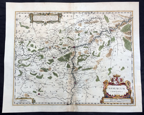
1636 Mercator Hondius Large Antique Map of Namur Region of Belgium, Huy & Meuse
- Title : Namurcum Comitatus 1632
- Date : 1636
- Size: 22in x 18in (570mm x 470mm)
- Ref #: 41622
- Condition: (A) Very Good Condition
Description:
This beautifully hand coloured original antique map of the Belgium region of Namur - centering on the cities of Namur, Huy, Dinant and the Meuse River - was engraved in 1632 by Henricus Hondius - dated - and was published in the rare 1636 English edition of Mercator's Atlas, by Henricus Hondius and Jan Jansson.
As there were so few of these atlases published with English text on the verso that maps from them are now understandably scarce.
Background: Namur is a province of Wallonia, one of the three regions of Belgium. It borders (clockwise from the West) on the Walloon provinces of Hainaut, Walloon Brabant, Liège and Luxembourg in Belgium, and on France. Its capital is the city of Namur.
The text running for two pages on the verso of this map describes the region or country name, history (as it was), temperature, seasons, soil and agricultural productivity. Also described is the topography, wildlife, local inhabitants their culture and religion, as well as a description of major European and local towns and cities. This text makes extremely enjoyable reading and a very good insight not only into the area described but the general European attitudes towards alien countries and cultures. (Ref: Koeman; M&B; Tooley)
Condition Report:
Paper thickness and quality: - Heavy and stable
Paper color: - off white
Age of map color: - Original
Colors used: - Yellow, pink, green
General color appearance: - Authentic
Paper size: - 22in x 18in (570mm x 470mm)
Plate size: - 19 1/2in x 15in (500mm x 380mm)
Margins: - Min 1in (25mm)
Imperfections:
Margins: - Left margin repaired
Plate area: - Centrefold re-joined with small loss to bottom border
Verso: - Centerfold re-joined, colour bleed through.
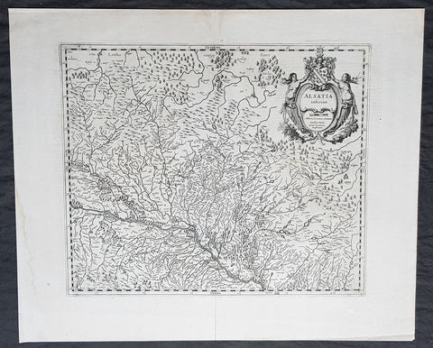
1638 Gerard Mercator & Henricus Hondius Antique Map of Alsace Region, France
- Title : Alsatia inferior..Per Gerardam Mercatorem Cum privilegio
- Size: 21in x 17in (530mm x 430mm)
- Condition: (A+) Fine Condition
- Date : 1638
- Ref #: 92839
Description:
This original copper plate engraved antique map of the French region of Alsace by Gerard Mercator was published by Henricus Hondius in the early 1638 German edition of Gerard Mercators Atlas.
These maps, published in the early editions of Mercators atlas, are the original maps drawn and engraved by Gerald Mercator in the mid to late 16th century, published by his son Rumold as an atlas, after his death, in 1595. After two editions the plates were purchased by Jodocus Hondius in 1604, and continued to be published until the end of the 1630s by Henricus Hondius, when some of the plates were re-engraved and updated with the help of Jan Jansson.
General Definitions:
Paper thickness and quality: - Heavy and stable
Paper color : - off white
Age of map color: -
Colors used: -
General color appearance: -
Paper size: - 21in x 17in (530mm x 430mm)
Plate size: - 18 1/2in x 14in (475mm x 350mm)
Margins: - Min 1/2in (12mm)
Imperfections:
Margins: - Light age toning
Plate area: - None
Verso: - None
Background:
Alsace is a cultural and historical region in eastern France, on the west bank of the upper Rhine next to Germany and Switzerland.
As in much of Europe, the prosperity of Alsace came to an end in the 14th century by a series of harsh winters, bad harvests, and the Black Death. These hardships were blamed on Jews, leading to the pogroms of 1336 and 1339. In 1349, Jews of Alsace were accused of poisoning the wells with plague, leading to the massacre of thousands of Jews during the Strasbourg pogrom. Jews were subsequently forbidden to settle in the town. An additional natural disaster was the Rhine rift earthquake of 1356, one of Europes worst which made ruins of Basel. Prosperity returned to Alsace under Habsburg administration during the Renaissance.
Holy Roman Empire central power had begun to decline following years of imperial adventures in Italian lands, often ceding hegemony in Western Europe to France, which had long since centralized power. France began an aggressive policy of expanding eastward, first to the rivers Rhône and Meuse, and when those borders were reached, aiming for the Rhine. In 1299, the French proposed a marriage alliance between Philip IV of Frances sister Blanche and Albert I of Germanys son Rudolf, with Alsace to be the dowry; however, the deal never came off. In 1307, the town of Belfort was first chartered by the Counts of Montbéliard. During the next century, France was to be militarily shattered by the Hundred Years War, which prevented for a time any further tendencies in this direction. After the conclusion of the war, France was again free to pursue its desire to reach the Rhine and in 1444 a French army appeared in Lorraine and Alsace. It took up winter quarters, demanded the submission of Metz and Strasbourg and launched an attack on Basel.
In 1469, following the Treaty of St. Omer [fr], Upper Alsace was sold by Archduke Sigismund of Austria to Charles the Bold, Duke of Burgundy. Although Charles was the nominal landlord, taxes were paid to Frederick III, Holy Roman Emperor. The latter was able to use this tax and a dynastic marriage to his advantage to gain back full control of Upper Alsace (apart from the free towns, but including Belfort) in 1477 when it became part of the demesne of the Habsburg family, who were also rulers of the empire. The town of Mulhouse joined the Swiss Confederation in 1515, where it was to remain until 1798.
By the time of the Protestant Reformation in the 16th century, Strasbourg was a prosperous community, and its inhabitants accepted Protestantism in 1523. Martin Bucer was a prominent Protestant reformer in the region. His efforts were countered by the Roman Catholic Habsburgs who tried to eradicate heresy in Upper Alsace. As a result, Alsace was transformed into a mosaic of Catholic and Protestant territories. On the other hand, Mömpelgard (Montbéliard) to the southwest of Alsace, belonging to the Counts of Württemberg since 1397, remained a Protestant enclave in France until 1793.
This situation prevailed until 1639, when most of Alsace was conquered by France to keep it out of the hands of the Spanish Habsburgs, who by secret treaty in 1617 had gained a clear road to their valuable and rebellious possessions in the Spanish Netherlands, the Spanish Road. Beset by enemies and seeking to gain a free hand in Hungary, the Habsburgs sold their Sundgau territory (mostly in Upper Alsace) to France in 1646, which had occupied it, for the sum of 1.2 million Thalers. When hostilities were concluded in 1648 with the Treaty of Westphalia, most of Alsace was recognized as part of France, although some towns remained independent. The treaty stipulations regarding Alsace were complex. Although the French king gained sovereignty, existing rights and customs of the inhabitants were largely preserved. France continued to maintain its customs border along the Vosges mountains where it had been, leaving Alsace more economically oriented to neighbouring German-speaking lands. The German language remained in use in local administration, in schools, and at the (Lutheran) University of Strasbourg, which continued to draw students from other German-speaking lands. The 1685 Edict of Fontainebleau, by which the French king ordered the suppression of French Protestantism, was not applied in Alsace. France did endeavour to promote Catholicism. Strasbourg Cathedral, for example, which had been Lutheran from 1524 to 1681, was returned to the Catholic Church. However, compared to the rest of France, Alsace enjoyed a climate of religious tolerance.
France consolidated its hold with the 1679 Treaties of Nijmegen, which brought most remaining towns under its control. France seized Strasbourg in 1681 in an unprovoked action. These territorial changes were recognised in the 1697 Treaty of Ryswick that ended the War of the Grand Alliance.
The year 1789 brought the French Revolution and with it the first division of Alsace into the départements of Haut- and Bas-Rhin. Alsatians played an active role in the French Revolution. On 21 July 1789, after receiving news of the Storming of the Bastille in Paris, a crowd of people stormed the Strasbourg city hall, forcing the city administrators to flee and putting symbolically an end to the feudal system in Alsace. In 1792, Rouget de Lisle composed in Strasbourg the Revolutionary marching song La Marseillaise (as Marching song for the Army of the Rhine), which later became the anthem of France. La Marseillaise was played for the first time in April of that year in front of the mayor of Strasbourg Philippe-Frédéric de Dietrich. Some of the most famous generals of the French Revolution also came from Alsace, notably Kellermann, the victor of Valmy, Kléber, who led the armies of the French Republic in Vendée and Westermann, who also fought in the Vendée.
At the same time, some Alsatians were in opposition to the Jacobins and sympathetic to the restoration of the monarchy pursued by the invading forces of Austria and Prussia who sought to crush the nascent revolutionary republic. Many of the residents of the Sundgau made pilgrimages to places like Mariastein Abbey, near Basel, in Switzerland, for baptisms and weddings. When the French Revolutionary Army of the Rhine was victorious, tens of thousands fled east before it. When they were later permitted to return (in some cases not until 1799), it was often to find that their lands and homes had been confiscated. These conditions led to emigration by hundreds of families to newly vacant lands in the Russian Empire in 1803–4 and again in 1808. A poignant retelling of this event based on what Goethe had personally witnessed can be found in his long poem Hermann and Dorothea.
In response to the hundred day restoration of Napoleon I of France in 1815, Alsace along with other frontier provinces of France was occupied by foreign forces from 1815 to 1818, including over 280,000 soldiers and 90,000 horses in Bas-Rhin alone. This had grave effects on trade and the economy of the region since former overland trade routes were switched to newly opened Mediterranean and Atlantic seaports.
The population grew rapidly, from 800,000 in 1814 to 914,000 in 1830 and 1,067,000 in 1846. The combination of economic and demographic factors led to hunger, housing shortages and a lack of work for young people. Thus, it is not surprising that people left Alsace, not only for Paris – where the Alsatian community grew in numbers, with famous members such as Baron Haussmann – but also for more distant places like Russia and the Austrian Empire, to take advantage of the new opportunities offered there: Austria had conquered lands in Eastern Europe from the Ottoman Empire and offered generous terms to colonists as a way of consolidating its hold on the new territories. Many Alsatians also began to sail to the United States, settling in many areas from 1820 to 1850. In 1843 and 1844, sailing ships bringing immigrant families from Alsace arrived at the port of New York. Some settled in Texas and Illinois, many to farm or to seek success in commercial ventures: for example, the sailing ships Sully (in May 1843) and Iowa (in June 1844) brought families who set up homes in northern Illinois and northern Indiana. Some Alsatian immigrants were noted for their roles in 19th-century American economic development. Others ventured to Canada to settle in southwestern Ontario, notably Waterloo County.
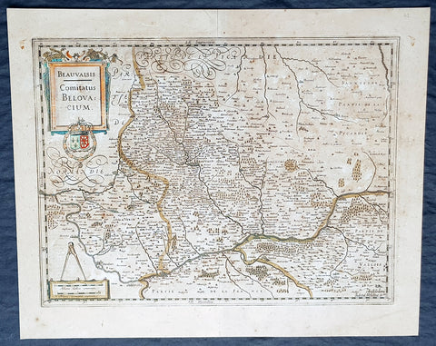
1638 Gerard Mercator & Henricus Hondius Antique Map of Beauvais Region, France
- Title : Beauvaisis Comitatus Belovacium
- Size: 21in x 17in (530mm x 430mm)
- Condition: (A) Very Good Condition
- Date : 1638
- Ref #: 50178
Description:
This original copper plate engraved antique map of the Beauvais region of Northern France - centering on the city of Beauvais & the Oise River running through the cities of Noyon, Compiègne, Creil by Gerard Mercator was published by Henricus Hondius in the early 1638 Latin edition of Gerard Mercators Atlas.
These maps, published in the early editions of Mercators atlas, are the original maps drawn and engraved by Gerald Mercator in the mid to late 16th century, published by his son Rumold as an atlas, after his death, in 1595. After two editions the plates were purchased by Jodocus Hondius in 1604, and continued to be published until the end of the 1630s by Henricus Hondius, when some of the plates were re-engraved and updated with the help of Jan Jansson.
General Definitions:
Paper thickness and quality: - Heavy and stable
Paper color : - off white
Age of map color: - Original
Colors used: - Blue, pink, red, green, yellow
General color appearance: - Authentic
Paper size: - 21in x 17in (530mm x 430mm)
Plate size: - 18 1/2in x 14in (475mm x 350mm)
Margins: - Min 1/2in (12mm)
Imperfections:
Margins: - Age toning
Plate area: - Age toning
Verso: - Age toning
Background:
Beauvais is a city and commune in northern France. It serves as the capital of the Oise département, in the Hauts-de-France region. Beauvais is located approximately 75 kilometres from Paris.
Beauvais was known to the Romans by the Gallo-Roman name of Caesaromagus (magos is Common Celtic for field). The post-Renaissance Latin rendering is Bellovacum from the Belgic tribe the Bellovaci, whose capital it was. In the ninth century it became a countship, which about 1013 passed to the bishops of Beauvais, who became peers of France from the twelfth century. At the coronations of kings the Bishop of Beauvais wore the royal mantle and went, with the Bishop of Langres, to raise the king from his throne to present him to the people.
De Bello Gallico II 13 reports that as Julius Caesar was approaching a fortified town called Bratuspantium in the land of the Bellovaci, its inhabitants surrendered to him when he was about 5 Roman miles away. Its name is Gaulish for place where judgements are made, from *bratu-spantion. Some say that Bratuspantium is Beauvais. Others theorize that it is Vendeuil-Caply or Bailleul sur Thérain.
From 1004 to 1037, the Count of Beauvais was Odo II, Count of Blois.
In a charter dated 1056/1060, Eudo of Brittany granted land in pago Belvacensi (Beauvais, Picardy) to the Abbey of Angers Saint-Aubin
In 1346 the town had to defend itself against the English, who again besieged it in 1433. The siege which it endured in 1472 at the hands of the Duke of Burgundy, was rendered famous by the heroism of the towns women, under the leadership of Jeanne Hachette, whose memory is still celebrated by a procession on 27 June (the feast of Sainte Angadrême), during which women take precedence over men.
An interesting hoard of coins from the High Middle Ages became known as the Beauvais Hoard, because some of the British and European coins found with the lot were from the French abbey located in Beauvais. The hoard, which contained a variety of rare and extremely rare Anglo-Norman pennies, English and foreign coins, was reputed to have been found in or near Paris.
1639 Hondius & Mercator Antique Map of Morea The Greek Peloponnese
- Title : Morea olim Peloponnesus
- Date : 1639
- Size: 23in x 19in (585mm x 480mm)
- Ref #: 43164
- Condition: (A+) Fine Condition
Description:
This fine, beautifully hand coloured original antique map of the Greek Peloponnese was published in the 1639 French edition of Gerardi Mercators Atlantis Novi Atlas by Jan Jansson and Henricus Hondius.
Background: The Peloponnese Peninsula had played a central role in both history and culture since Homeric times. The large peninsula is connected to mainland Greece only by the narrow Isthmus of Corinth, and jutting deeply southwards, it lay along the crossroads of shipping in the Mediterranean and Aegean seas. Many places still familiar today are labelled on the map, including 'Coryato' (Corinth), 'Napoli' (Nafplio), Patras and 'Cithera' (Cythera), while Athens appears in Attica, to the northeast.
Prominenty featured in the upper part of the map is the Gulf of Lepanto in 1571, the site of an epic naval battle between the forces of the Ottoman Empire and the combined forces of various European states. The outcome was a historical turning point, as it ensured Western maritime supremacy over the Ottomans for decades to come. Even in 1619, almost half a century later, when the present map was printed, the Battle of Lepanto was still top of mind. (Ref: Koeman; M&B)
Condition Report:
Paper thickness and quality: - Heavy & stable
Paper color: - off white
Age of map color: - Original
Colors used: - Yellow, pink, green
General color appearance: - Authentic
Paper size: - 23in x 19in (585mm x 480mm)
Plate size: - 16 1/2in x 13 1/2in (420mm x 345mm)
Margins: - Min 1in (25mm)
Imperfections:
Margins: - Light age toning
Plate area: - None
Verso: - Bottom centerfold re-joined, no loss

1639 Mercator & Hondius Large Antique Map of Greece, Aegean Islands & Turkey
- Title : Nova Totius Graeciae descriptio
- Date : 1639
- Size: 22in x 18 1/2in (560mm x 470mm)
- Ref #: 43151
- Condition: (A) Very Good Condition
Description:
This fine, beautifully hand coloured original antique map of Greece, Aegean Islands & Turkey was published in the 1639 French edition of Gerardi Mercators Atlantis Novi Atlas by Jan Jansson and Henricus Hondius.
Condition Report:
Paper thickness and quality: - Heavy & stable
Paper color: - off white
Age of map color: - Original
Colors used: - Yellow, pink, green
General color appearance: - Authentic
Paper size: - 22in x 18 1/2in (560mm x 470mm)
Plate size: - 18 1/2in x 14 1/2in (470mm x 350mm)
Margins: - Min 1in (25mm)
Imperfections:
Margins: - Bottom & top margin centre-fold re-joined, no loss
Plate area: - Repair to left side of image, no loss
Verso: - Repairs as noted
Background:
From the early days of map-making, cartographers have always had a keen interest he mapping of Greece and of the particular continental and insular Greek areas. In other words the "Greek chorography", as it is often called had been a cartographic item of special importance, both in manuscript and printed cartography, the later having produced an impressive number of Greek maps. All of these have been include in almost all the European Atlases and travel books, since the first printed edition of Ptolemy's Geographia in 1447. This prominent presence of Greece in the field of European cartography is due to various historic, political and cultural reasons. (Ref: Koeman; M&B)

1639 Mercator & Hondius Large Old, Antique Map of Wales, GB - Humphrey Llwyd
- Title : Cambriae Typus Auctore Humfredo Lhuydo Denbigiense Cambrobritanno
- Date : 1639
- Size: 23in x 19in (590mm x 485mm)
- Ref #: 43139
- Condition: (A+) Fine Condition
Description:
This beautifully hand coloured original antique map of Wales - dedicated to its original creator the Welsh cartographer Lhuyd Humphrey - by Gerard Mercator was published by Jodocus Hondius in the 1639 French edition of Mercators Atlas.
One of the best examples I seen of this map to date, beautiful original hand colour with strong sturdy paper with a deep strong impression.
Humphrey Llwyd (also spelled Lhuyd) (1527–1568) was a Welsh cartographer , author, antiquary and Member of Parliament. He was a leading member of the Renaissance period in Wales along with other such men as Thomas Salisbury and William Morgan.
Llwyd was born in Denbigh, the county seat of the then county of Denbighshire at Foxhall, his family's estate. His father, Robert Llwyd, was descended from Harry Rossendale, henchman and grantee of the Earl of Lincoln. The first of the family that came to Wales from England appears to have been Foulk Rosindale, from whom Foxhall, or Foulk's Hall, was called. He married into the family of the Llwyd's of Aston, and probably from where his descendants derived their name, as well as their extraction from Einion Evell of the 12th Century. Einion Evell, Lord of part of Cynllaith, resided at Llwyn y Macn, in the parish of Oswestry. He and his twin brother, Cynwrig Evell, Lord of Y Glwyegl in Maelor Gymraeg, were the illegitimate sons of Madog ab Maredydd, Prince of Powys, by Eva, daughter of Madog (ab Einion Hael) ab Urien of Macn Gwynedd, ab Eginirab Lies ab Idnerth Benvras, Lord of Maesbrwg.
As a young man, he was educated at Brasenose College, Oxford and fared so well in the sciences and engineering that he was given a position as a physician to the Earl of Arundel during the Earl's tenure as Chancellor of the university. He was MP for East Grinstead during Elizabeth I's first parliament (1559).
In 1563, Llwyd returned to Denbigh and lived at Denbigh Castle at the permission of Sir John Salusbury who was then the Lord of the Manor of Denbigh. That year, he was elected MP for Denbigh Boroughs during Elizabeth's second Parliament where he promoted an act allowing the translation of the Bible into Welsh.
From 1566 he toured Europe, including Brussels, Augsburg, Milan, Padua and Venice. In Antwerp, he learnt from, and collaborated with, map maker Abraham Ortelius. In 1567, when Llwyd returned to Denbigh, he was given a stipend from the Crown to create the first printed map of Wales.
Llwyd died in 1568 and is buried in Whitchurch, a small chapel on the outskirts of Denbigh
Jodocus Hondius (1563 - 1612), one of the most notable engravers of his time, is known for his work in association with many of the cartographers and publishers prominent at the end of the sixteenth and the beginning of the seventeenth century.
In 1604 Hondius bought the plates of Mercator's Atlas which, in spite of its excellence, had not competed successfully with the continuing demand of the Ortelius Theatrum Orbis Terrarum.
To meet this competition Hondius added about 40 maps to Mercator's original number and from 1606 published enlarged editions in many languages, still under Mercator's name but with his own name as publisher. These atlases have become known as the Mercator/Hondius series. The following year the maps were re-engraved in miniature form and issued as a pocket Atlas Minor.
After the death of Jodocus Hondius the Elder in 1612, work on the two atlases, folio and miniature, was carried on by his widow and sons, Jodocus II and Henricus, and eventually in conjunction with Jan Jansson in Amsterdam. In all, from 1606 onwards, nearly 50 editions with increasing numbers of maps with texts in the main European languages were printed. (Ref: Koeman; M&B; Tooley)
Condition Report:
Paper thickness and quality: - Heavy & stable
Paper color: - off white
Age of map color: - Original
Colors used: - Yellow, pink, green, blue
General color appearance: - Authentic
Paper size: - 23in x 19in (590mm x 485mm)
Plate size: - 19 1/2in x 14in (500mm x 360mm)
Margins: - Min 1in (25mm)
Imperfections:
Margins: - Light toning to bottom of margin
Plate area: - None
Verso: - None
1639 Mercator Hondius Antique Map of Gulf of Venice, Istra, Italy, Slovenia
- Title : Karstia, Carniola, Histria et Windorum Marchia
- Ref #: 43152
- Size: 21 1/2in x 18 1/2in (550mm x 470mm)
- Date : 1639
- Condition: (A+) Fine Condition
Description:
This beautifully hand coloured original antique map of northern Adriatic Sea and the Gulf of Venice centered on Istria, showing present-day north-eastern Italy, a large part of Slovenia and northern Croatia - extending from Venice to the Island of Arbe and from Doblach to Pettau on the Dravus River - engraved by Gerard Mercator, was published by 1639 French edition of Mercators Atlas by Jan Jansson and Henricus Hondius.
These maps, published in the later editions of Mercators atlas, are derived from the original maps drawn and engraved by Gerald Mercator in the mid to late 16th century, published by his son Rumold as an atlas, after his death, in 1595. After two editions the plates were purchased by Jodocus Hondius in 1604 and continued to be published until the mid 1630's when the plates were re-engraved and updated by Jan Jansson and Henricus Hondius.
Condition Report:
Paper thickness and quality: - Heavy & stable
Paper color: - off white
Age of map color: - Original
Colors used: - Yellow, pink, green
General color appearance: - Authentic
Paper size: - 21 1/2in x 18 1/2in (550mm x 470mm)
Plate size: - 18 1/2in x 14 1/2in (470mm x 350mm)
Margins: - Min 1in (25mm)
Imperfections:
Margins: - Bottom left margin corner repaired, no affect on image
Plate area: - Creasing along centerfold
Verso: - None
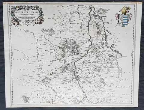
1650 Joan Blaeu Antique Map Archbishopic of Madenburg in Saxony-Anhalt, Germany
- Title : Magdeburgensis Archiepiscopatus...Amstelaedami J Blaeu excudebat
- Size: 21in x 17in (530mm x 430mm)
- Condition: (A+) Fine Condition
- Date : 1650
- Ref #: 70075
Description:
This beautifully hand coloured original copper-plate engraved antique map of the Archbishopric of Madenburg today located in the state of Saxony-Anhalt, Germany, on the Elbe River, was published in the 1650 edition of Joan Blaeus Atlas Novus.
General Definitions:
Paper thickness and quality: - Heavy and stable
Paper color : - off white
Age of map color: - Original
Colors used: - Yellow, Green, pink
General color appearance: - Authentic
Paper size: - 21in x 17in (530mm x 430mm)
Plate size: - 21in x 17in (530mm x 430mm)
Margins: - Min 1/4in (6mm)
Imperfections:
Margins: - Top margin cropped to plate-mark
Plate area: - None
Verso: - None
Background:
The Archbishopric of Magdeburg was a Roman Catholic archdiocese (969–1552) and Prince-Archbishopric (1180–1680) of the Holy Roman Empire centered on the city of Magdeburg on the Elbe River.
Planned since 955 and established in 968, the Roman Catholic archdiocese had de facto turned void since 1557, when the last papally confirmed prince-archbishop, the Lutheran Sigismund of Brandenburg came of age and ascended to the see and the Magdeburg cathedral chapter had adopted Lutheranism in 1567, with most parishioners having preceded in their conversion. All his successors were only administrators of the prince-archbishopric and Lutheran too, except of the Catholic layman Leopold William of Austria (1631–1635). In ecclesiastical respect the remaining Catholics and their parishes and abbeys in the former archdiocese were put under supervision of the Archdiocese of Cologne in 1648 and under the jurisdiction of the Apostolic Vicariate of the Northern Missions in 1670.
In political respect the Erzstift, the archiepiscopal and capitular temporalities, had gained imperial immediacy as prince-archbishopric in 1180. Its territory comprised only some parts of the archdiocesan area, such as the city of Magdeburg, the bulk of the Magdeburg Börde, and the Jerichow Land as an integral whole and exclaves comprising about the Saalkreis including Halle upon Saale, Oebisfelde and environs as well as Jüterbog and environs. The prince-archbishopric maintained its statehood as an elective monarchy until 1680. Then Brandenburg-Prussia acquired Magdeburg prince-archbishopric, and after being secularised, transformed it into the Duchy of Magdeburg, a hereditary monarchy in personal union with Brandenburg.

1691 Alex Jaillot Large Antique Map of South America, Gold Imperial Highlights
Antique Map
- Title : Amerique Meridionale Divisee en ses Principales Parties...1691
- Ref #: 35630
- Condition: (A+) Fine Condition
- Size: 37 1/2in x 24 3/4in (940mm x 630mm)
- Date: 1691
Description:
This original beautifully hand coloured (with gold highlights) antique very large map of South America was engraved in 1691 - dated in Cartouche - and was published by Hubert Jaillot in his monumental Atlas Nouveau.
This map is beautifully hand coloured with gold highlights along country borders and the cartouches indicating it was once part of an Imperial Atlas.
The Imperial atlases were hand coloured using gold highlights and other rare colours which at the time was extremely expensive and available at the time only to royalty and the very rich.
General Definitions:
Paper thickness and quality: - Heavy and stable
Paper color : - Off white
Age of map color: - Original
Colors used: - Yellow, green, blue, pink, blue, gold
General color appearance: - Authentic
Paper size: - 37 1/2in x 24 3/4in (940mm x 630mm)
Plate size: - 35 1/2in x 23in (900mm x 590mm)
Margins: - Min 1in (25mm)
Imperfections:
Margins: - Age toning along margins
Plate area: - Crease along centerfold
Verso: - None
Background:
The map include lines of latitude and longitude, some topographical details, location of settlements, rivers, and lakes (including the lakes Parime, thought to be where the fabulous El Dorado was located) as well as the boundaries of the possessions of the European claimants to South America.
Extremely decorative cartouche with dedication to Le Dauphin, and his coat of arms in top.
After Nicolas Sanson, Hubert Jaillot and Pierre Duval were the most important French cartographers of the seventeenth & eighteenth centuries. Jaillot, originally a sculptor, became interested in geography after his marriage to the daughter of Nicolas Berey (1606-65), a famous map colourist, and went into partnership in Paris with Sanson's sons. There, from about 1669, he undertook the re-engraving, enlarging and re-publishing of the Sanson maps in sheet form and in atlases, sparing no effort to fill the gap in the map trade left by the destruction of Blaeu's printing establishment in Amsterdam in 1672. Many of his maps were printed in Amsterdam (by Pierre Mortier) as well as in Paris. One of his most important works was a magnificent sea atlas, Le Neptune François, published in 1693 and compiled in co-operation with J D Cassini. This was re-published shortly afterwards by Pierre Mortier in Amsterdam with French, Dutch and English texts, the charts having been re-engraved. Eventually, after half a century, most of the plates were used again as the basis for a revised issue published by J N Bellin in 1753.(Ref: Tooley; M&B)

1692 Alex Jaillot Large Antique Map of Italy, Sicily - Gold Imperial Highlights
Antique Map
- Title : L' Italie Divisee Suivant Les l'estendue de tous Les Estats, Royaumes, Republiques, Duches, Principates...1692.
- Ref #: 35631
- Condition: (A+) Fine Condition
- Size: 37 1/2in x 24 3/4in (940mm x 630mm)
- Date: 1691
- Price: $1599.00US
Description:
This original, beautifully hand coloured (with gold highlights) antique, very large map of Italy was engraved in 1692 - dated in Cartouche - and was published by Hubert Jaillot in his monumental Atlas Nouveau.
This map is beautifully hand coloured with gold highlights along country borders and the cartouches indicating it was once part of an Imperial Atlas.
The Imperial atlases were hand coloured using gold highlights and other rare colours which at the time was extremely expensive and available at the time only to royalty and the very rich.
General Definitions:
Paper thickness and quality: - Heavy and stable
Paper color : - Off white
Age of map color: - Original
Colors used: - Yellow, green, blue, pink, blue, gold
General color appearance: - Authentic
Paper size: - 37 1/2in x 24 3/4in (940mm x 630mm)
Plate size: - 35 1/2in x 23in (900mm x 590mm)
Margins: - Min 1in (25mm)
Imperfections:
Margins: - None
Plate area: - Light offsetting
Verso: - Age toning to verso
Background:
Since classical times the countries bordering the enclosed waters of the Mediterranean had been well versed in the use of maps and sea charts and in Italy, more than anywhere else, the traditional knowledge was kept alive during the many hundreds of years following the collapse of the Roman Empire. By the thirteenth and fourteenth centuries the seamen of Venice, Genoa and Amalfi traded to far countries, from the Black Sea ports and the coasts of Palestine and Egypt in the East to Flanders and the southern coasts of England and Ireland in the West, their voyages guided by Portolan charts and the use of the newly invented compass. For a time Italian supremacy in cartography passed to Aragon and the Catalan map makers based on Majorca, but by the year 1400 the power and wealth of the city states of Venice, Genoa, Florence and Milan surpassed any in Europe. Florence, especially, under the rule of the Medici family, became not only a great trading and financial centre but also the focal point of the rediscovery of the arts and learning of the ancient world. In this milieu a number of manuscript world maps were produced, of which one by Fra Mauro (c. 1459) is the most notable, but the event of the greatest importance in the history of cartography occurred in the year 1400 when a Florentine, Palla Strozzi, brought from Constantinople a Greek manuscript copy of Claudius Ptolemy's Geographia, which, 1,250 years after its compilation, came as a revelation to scholars in Western Europe. In the following fifty years or so manuscript copies, translated into Latin and other languages, became available in limited numbers but the invention of movable-type printing transformed the scene: the first copy without maps being printed in 1475 followed by many with copper-engraved maps, at Bologna in 1477, Rome 1478, 1490, 1507 and 1508, and Florence 1482.
About the year 1485 the first book of sea charts, compiled by Bartolommeo dalli Sonetti, was printed in Venice and in the first part of the sixteenth century a number of world maps were published, among them one compiled in 1506 by Giovanni Contarini, engraved by Francesco Rosselli, which was the first printed map to show the discoveries in the New World. In the following years there were many attractive and unusual maps of Islands (Isolano) by Bordone, Camocio and Porcacchi, but more important was the work of Giacomo (Jacopo) Gastaldi, a native of Piedmont who started life as an engineer in the service of the Venetian Republic before turning to cartography as a profession. His maps, produced in great variety and quantity, were beautifully drawn copperplate engravings and his style and techniques were widely copied by his contemporaries. From about 1550 to 1580 many of Gastaldi's maps appeared in the collections of maps known as Lafreri 'atlases', a term applied to groups of maps by different cartographers brought together in one binding. As the contents of such collections varied considerably they were no doubt assembled at the special request of wealthy patrons and are now very rare indeed.
About this time, for a variety of historical and commercial reasons, Italy's position as the leading trading and financial nation rapidly declined and with it her superiority in cartography was lost to the vigorous new states in the Low Countries. That is not to say, of course, that Italian skills as map makers were lost entirely for it was not until 1620 that the first printed maps of Italy by an Italian, Giovanni Magini, appeared, and much later in the century there were fine maps by Giacomo de Rossi and Vincenzo Coronelli, the latter leading a revival of interest in cartography at the end of the century. Coronelli was also famous for the construction of magnificent large-size globes and for the foundation in Venice in 1680 of the first geographical society.
In the eighteenth century the best-known names are Antonio Zatta, Rizzi-Zannoni and Giovanni Cassini.
We ought to mention the work of Baptista Boazio who drew a series of maps in A Summarie and True Discourse of Sir Francis Drake's West Indian Voyage, published in 1588-89, and who is especially noted for a very fine map of Ireland printed in 1599 which was incorporated in the later editions of the Ortelius atlases. It is perhaps appropriate also to refer to two English map makers who spent many years in exile in Italy: the first, George Lily, famous for the splendid map of the British Isles issued in Rome in 1546, and the second, Robert Dudley, who exactly one hundred years later was responsible for the finest sea atlas of the day, Dell' Arcano del Mare, published in Florence. Both of these are described in greater detail elsewhere in this handbook. (Ref: Tooley, Koeman)