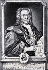
Georg Matthaus Seutter (1678-1756)
Profile :
After serving an apprenticeship to J.B. Homann, the successful map publisher, Seutter set up his own very successful business in Augsburg and was appointed Geographer to the Imperial Court. With his son and son-in-law, Conrad Lotter, he issued in about 1741 a large series of town plans. For much of his life he worked in competition with his old employer and, not surprisingly, his maps were often similar to those of Homann.
Georg Matthaus Seutter (32)
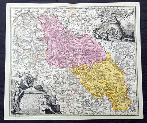
1730 G M Seutter Large Antique Map of The Silesia Region of Poland inset Wroclaw
- Title : Silesia Ducatus tam Superior...Matth. Seutteri...
- Ref #: 93483
- Size: 24 1/2in x 21in (615mm x 525mm)
- Date : 1730
- Condition: (A+) Fine Condition
Description:
This original large beautifully hand coloured copper plate engraved antique map of the ancient region of Silesia, now located in Western Poland - with an inset plan of the city of Wroclaw (Breslau) - was published by GM Seutter in 1730 (Ref: Tooley; M&B)
General Definitions:
Paper thickness and quality: - Heavy and stable
Paper color : - off white
Age of map color: - Original
Colors used: - Blue, pink, red, green, yellow
General color appearance: - Authentic
Paper size: - 24 1/2in x 21in (615mm x 525mm)
Plate size: - 23in x 20in (590mm x 505mm)
Margins: - Min 1in (25mm)
Imperfections:
Margins: - None
Plate area: - Light discolouration to top centerold
Verso: - None
Background:
Silesia is a historical region of Central Europe mostly in Poland, with small parts in the Czech Republic and Germany. Its area is approximately 40,000 km2, and the population is estimated at around 8,000,000 inhabitants. Silesia is split into two main sub-regions of Lower Silesia in the west and Upper Silesia in the east. Silesia has a diverse culture, including architecture, costumes, cuisine, traditions, and the Silesian language.
Silesia is along the Oder River, with the Sudeten Mountains extending across the southern border. The region possesses many historical landmarks and UNESCO World Heritage Sites. It is also rich in mineral and natural resources, and includes several important industrial areas. Silesias largest city and historical capital is Wrocław. The biggest metropolitan area is the Upper Silesian metropolitan area, the centre of which is Katowice. Parts of the Czech city of Ostrava and the German city of Görlitz fall within the borders of Silesia.
Silesias borders and national affiliation have changed over time, both when it was a hereditary possession of noble houses and after the rise of modern nation-states. The varied history with changing aristocratic possessions resulted in an abundance of castles, especially in the Jelenia Góra valley. The first known states to hold power in Silesia were probably those of Greater Moravia at the end of the 9th century and Bohemia early in the 10th century. In the 10th century, Silesia was incorporated into the early Polish state, and after its division in the 12th century became a Piast duchy. In the 14th century, it became a constituent part of the Bohemian Crown Lands under the Holy Roman Empire, which passed to the Austrian Habsburg Monarchy in 1526. As a result of the Silesian Wars, the region was annexed by Prussia in 1742.
After World War I, the easternmost part of Upper Silesia was granted to Poland by the Entente Powers after insurrections by Poles and the Upper Silesian plebiscite. The remaining former Austrian parts of Silesia were partitioned to Czechoslovakia, forming part of Czechoslovakias Sudetenland region, and are today part of the Czech Republic. In 1945, after World War II, the bulk of Silesia was transferred to Polish jurisdiction by the Potsdam Agreement between the victorious Allies and became part of Poland, whose Communist government expelled the majority of Silesias previous population. The small Lusatian strip west of the Oder–Neisse line, which had belonged to Silesia since 1815, remained in Germany.
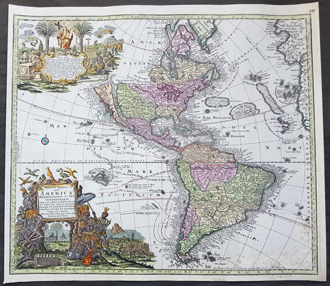
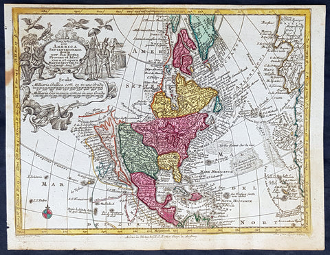
1730 Georg M Seutter Original Antique Map of America, Island of California
- Title : Novus Orbis sive America Meridionalis et Septentrionalis
- Date : 1730
- Size: 23 3/4in x 21in (605mm x 535mm)
- Ref #: 70793
- Condition: (A+) Fine Condition
Description:
This large handsome and beautifully hand coloured original antique map of America - showing California as an Island - was published by Georg Mattraus Seutter in 1730.
One of the best examples of this map I have seen to date with exceptional hand colouring.
General Definitions:
Paper thickness and quality: - Heavy and stable
Paper color : - off white
Age of map color: - Original & later
Colors used: - Yellow, green, blue, pink
General color appearance: - Authentic
Paper size: - 23 3/4in x 21in (605mm x 535mm)
Plate size: - 23in x 20in (585mm x 510mm)
Margins: - Min 1/2in (12mm)
Imperfections:
Margins: - None
Plate area: - Light spotting bottom right of map
Verso: - None
Background:
This is a highly decorative and informative map based on the contemporary European knowledge of America at the beginning of the 18th century. California is shown as an island based on the Sanson-Homann model but with additions including several more rivers on the west coast and two mountains to the north - M. Neges and M.S. Martin and C de Fortuna, C&R de Pins and many others.
The great lakes still show a large degree of ignorance to both shape and location and the NW is left blank. Brazil and the east coast of South America is still largely exaggerated.
The tracks of the early navigators are shown in the Pacific including Fr. Quir, Magellan, Drake and others.
The map also supports two large and highly decorative uncoloured - as published - cartouches which in themselves tell a story of European conquest and ignorance of the local populations.
Religion was a compelling motivation for European imperialism, and the opportunity to convert \"heathen\" Indians provided both a justification and means to conquer the indigenous peoples of the New World. Two Indians kneel reverently before a female figure representing Christianity in the top cartouche, flanked on the right by an altar prepared for Holy Communion and on the left by Europeans at a dining table.
The lower cartouche portrays tranquil Indians surrounded by standard symbols representing the Americas. The seated figure wears a feathered headdress, armband, and skirt. A servant shades him from the sun with a baldachin (parasol), while others in the background and to the left harvest what appears to be sugarcane and tobacco. In the center background someone rests in a hammock suspended between two palm trees while another rows quietly out to sea. A pelican, a cockatiel, and whimsical flying fish, some sporting saw-like beaks, hover above the title. The latter creatures appear to be the artist\'s misconception of a sawfish.
The placement of the two scenes illustrating this work is significant. By depicting numerous symbols associated with Roman Catholicism above a scene of Indians, a subtle message is conveyed: European contact with Indians would yield vast spiritual riches in the form of Christian converts and benefit the indigenous people, who, because they did not practice a Christian faith, were \"beneath\" those who did. (Ref: M&B; Tooley)
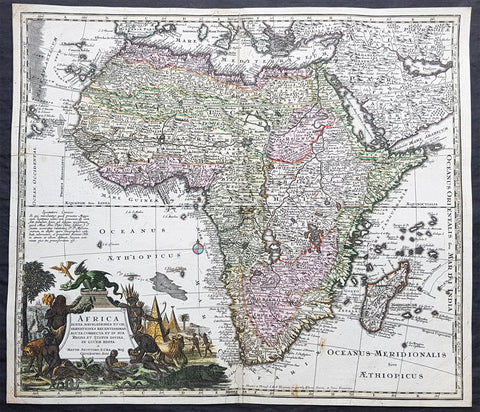
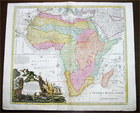
1730 Georg Mattraus Seutter Large Antique Map of Africa
- Title : Africa Iuxta Navigationes..Matth. Seuttero S Caes Maj Geographo Aug.
- Date : 1730
- Condition: (A) Very Good Condition
- Ref: 35011
- Size: 23in x 20in (585mm x 510mm)
Description:
This large beautifully hand coloured original copper-plate antique map of Africa was engraved by Tobais Lotter and published by Georg Mattraus Seutter in 1730 edition of Geographical Atlas or an Accurate Depiction of the Whole World
This striking map of Africa is based largely on Homanns 1715 map. Typical of the period, it presents largely fictitious information in southern Africa, and enormous lakes depicted in central Africa. The Nile is shown originating in the south at lakes Zaire and Zaflan and also continuing further south through a twisted river system with its headwaters in Bed Lac. The splendid decorative cartouche (uncolored) features indigenous people, pyramids and exotic animals, with a fierce dragon perched atop the title.
General Definitions:
Paper thickness and quality: - Heavy and stable
Paper color : - off white
Age of map color: - Original
Colors used: - Yellow, green, blue, pink
General color appearance: - Authentic
Paper size: - 23in x 20in (585mm x 510mm)
Plate size: - 23in x 20in (585mm x 510mm)
Margins: - Min 1/2in (12mm)
Imperfections:
Margins: - Small restoration to top & bottom margin centerfold. 4 small rejoins to margins, no loss
Plate area: - Restoration to bottom 2in of centerfold
Verso: - Light soiling
Background:
The first separately printed map of Africa (as with the other known continents) appeared in Munster\'s Geographia from 1540 onwards and the first atlas devoted to Africa only was published in 1588 in Venice by Livio Sanuto, but the finest individual map of the century was that engraved on 8 sheets by Gastaldi, published in Venice in 1564. Apart from maps in sixteenth-century atlases generally there were also magnificent marine maps of 1596 by Jan van Linschoten (engraved by van Langrens) of the southern half of the continent with highly imaginative and decorative detail in the interior. In the next century there were many attractive maps including those of Mercator/Hondius (1606), Speed (1627), Blaeu (1 630), Visscher (1636), de Wit (c. 1670), all embellished with vignettes of harbours and principal towns and bordered with elaborate and colourful figures of their inhabitants, but the interior remained uncharted with the exception of that part of the continent known as Ethiopia, the name which was applied to a wide area including present-day Abyssinia. Here the legends of Prester John lingered on and, as so often happened in other remote parts of the world, the only certain knowledge of the region was provided by Jesuit missionaries. Among these was Father Geronimo Lobo (1595-1678), whose work A Voyage to Abyssinia was used as the basis for a remarkably accurate map published by a German scholar, Hiob Ludolf in 1683. Despite the formidable problems which faced them, the French cartographers G. Delisle (c. 1700-22), J. B. B. d\'Anville (1727-49) and N. Bellin (1754) greatly improved the standards of mapping of the continent, improvements which were usually, although not always, maintained by Homann, Seutter, de Ia Rochette, Bowen, Faden and many others in the later years of the century. (M&B; Tooley)
1730 Georg Mattraus Seutter Large Antique Map of Africa
- Title : Africa Iuxta Navigationes..Matth. Seuttero S Caes Maj Geographo Aug.
- Date : 1730
- Condition: (A) Very Good Condition
- Ref: 43003
- Size: 25 ½in x 21 ½in (650mm x 545mm)
Description:
This large beautifully hand coloured original copper-plate antique map of Africa was engraved by Tobais Lotter and published by Georg Mattraus Seutter in 1730 edition of Geographical Atlas or an Accurate Depiction of the Whole World
This striking map of Africa is based largely on Homanns 1715 map. Typical of the period, it presents largely fictitious information in southern Africa, and enormous lakes depicted in central Africa. The Nile is shown originating in the south at lakes Zaire and Zaflan and also continuing further south through a twisted river system with its headwaters in Bed Lac. The splendid decorative cartouche (uncolored) features indigenous people, pyramids and exotic animals, with a fierce dragon perched atop the title.
Condition Report
Paper thickness and quality: - Heavy and stable
Paper color: - off white
Age of map color: - Original & later
Colors used: - Yellow, pink, green, orange, blue
General color appearance: - Authentic
Paper size: - 25 ½in x 21 ½in (650mm x 545mm)
Plate size: - 23in x 20in (585mm x 510mm)
Margins: - Min 1in (25mm)
Imperfections:
Margins: - Two repairs to bottom margin, no loss
Plate area: - Two small professional repairs to center of image, not noticable
Verso: - None
Background:
The first separately printed map of Africa (as with the other known continents) appeared in Munster\'s Geographia from 1540 onwards and the first atlas devoted to Africa only was published in 1588 in Venice by Livio Sanuto, but the finest individual map of the century was that engraved on 8 sheets by Gastaldi, published in Venice in 1564. Apart from maps in sixteenth-century atlases generally there were also magnificent marine maps of 1596 by Jan van Linschoten (engraved by van Langrens) of the southern half of the continent with highly imaginative and decorative detail in the interior. In the next century there were many attractive maps including those of Mercator/Hondius (1606), Speed (1627), Blaeu (1 630), Visscher (1636), de Wit (c. 1670), all embellished with vignettes of harbours and principal towns and bordered with elaborate and colourful figures of their inhabitants, but the interior remained uncharted with the exception of that part of the continent known as Ethiopia, the name which was applied to a wide area including present-day Abyssinia. Here the legends of Prester John lingered on and, as so often happened in other remote parts of the world, the only certain knowledge of the region was provided by Jesuit missionaries. Among these was Father Geronimo Lobo (1595-1678), whose work A Voyage to Abyssinia was used as the basis for a remarkably accurate map published by a German scholar, Hiob Ludolf in 1683. Despite the formidable problems which faced them, the French cartographers G. Delisle (c. 1700-22), J. B. B. d\'Anville (1727-49) and N. Bellin (1754) greatly improved the standards of mapping of the continent, improvements which were usually, although not always, maintained by Homann, Seutter, de Ia Rochette, Bowen, Faden and many others in the later years of the century. (M&B; Tooley)
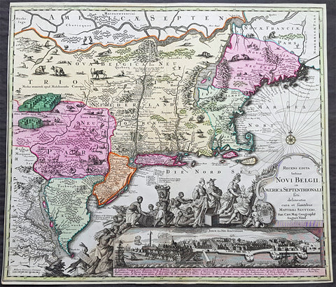
1730 Georg Seutter Antique Map of New England & New York City - Rare 2nd State
- Title : Recens edita totius Novi Belgii, in America Septentrionali siti, delineatio cura et sumtibus Matthaei Seutteri, Sac. Caes Maj. Geographf. August. Vind
- Size: 23in x 20 1/4in (585mm x 515mm)
- Condition: (A) Very Good Condition
- Date : 1730
- Ref #: 43001
Description:
This large beautifully hand coloured original antique map of the NE region of colonial North America, with the famous Restitutio inset birds-eye view of 17th century New York city, was engraved & published by Georg Mattraus Seutter in 1730.
This is the rare second state, identified by the omission of Chalcographi Augustani from the title and the blank shaded are directly below the title (text was added to the shaded area in the 3rd to 6th states) The cartouche and city view are uncoloured as was intended by Seutter along with the beautiful original map colouring.
This map is in exceptional condition with beautiful original colour, with heavy engraving (denoting an early pressing) on clean heavy sturdy paper. The top and left borders have been professionally extended, with no impact on the image.
There are, at the time of listing, nine of these maps for sale online, of states 2 to 6. Of the 9 only 2 are of the rare 2nd state. The average asking price of the nine maps is $4897US.
General Definitions:
Paper thickness and quality: - Heavy and stable
Paper color : - off white
Age of map color: - Original
Colors used: - Blue, pink, red, green, yellow
General color appearance: - Authentic
Paper size: - 23in x 20 1/4in (585mm x 515mm)
Plate size: - 23in x 20 1/4in (585mm x 515mm)
Margins: - Min 1/4in (5mm)
Imperfections:
Margins: - T & L margins extended
Plate area: - None
Verso: - None
Background:
The map is based upon the Jansson-Visscher New England series of maps, first published by Visscher in 1651. Seutter replaces the original Restitutio view of New York City with a new view of New York entitled Neu Jorck sive Neu Amsterdam, with a key to the view below in Latin. Above the view is an elaborate scene depicting natives, slaves & allegorical deities presenting tributes to the English monarch, George II. The course of the Delaware and Hudson are separated, unlike early editions of the map.
This is the first map in the series to show distinct drawn boundaries between Massachusetts, New England, New York, New Jersey and Pennsylvania, as earlier examples had previously left the delineation of the boundaries to the colorist. Philadelphia is now shown as a set of houses in relief, rather than a ground plan. The map is richly embellished with many animals and other decorations and is without doubt, one of the most decorative 18th century maps of the region.
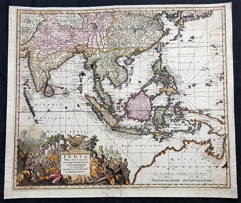
1730 Georg Seutter Large Antique Map Australia, China, SE Asia, Indonesia, India
- Title : India Orientalis cum Adjacentibus Insulis Nova Delineatione ob oculos posita..Matth. Seuttero
- Ref #: 93142
- Size: 24in x 20in (610mm x 510mm)
- Date : 1730
- Condition: (B) Good Condition
Description:
This large, beautifully hand coloured original antique map of the North & NW coastline of New Holland (Australia) East Asia, SE Asia, China, East Indies was published by Georg Mattraus Seutter in 1730.
The map is backed on 18th century contemporary paper and has old ink spots & lines but is overall a nice map and is priced accordingly.
General Definitions:
Paper thickness and quality: - Heavy and stable
Paper color : - off white
Age of map color: - Original
Colors used: - Yellow, green, blue, pink
General color appearance: - Authentic
Paper size: - 24in x 20in (610mm x 510mm)
Plate size: - 22 1/2in x 19in (565mm x 490mm)
Margins: - Min 1/2in (12mm)
Imperfections:
Margins: - Age toning, light soiling
Plate area: - Old ink marks & spots on map, light soiling, creasing
Verso: - Backed onto contemporary paper
Background:
The map extends from China, Japan and Persia in the North and in the south stretching from The Maldives east to Northern Australia. Of note, Australia continues to be attached to Nova Guinea, albeit with some hesitation, as the image extends outside the inner neat-line to convey this information - even though 20+ names are confidently engraved around Northern Australia Coastline.
The detail throughout Southeast Asia is informative and up-to-date and the print style typically strong.
The cartouche is one of Seutter\'s most ornate, with elaborate scenes from sea, land, jungle and mythology.
This map rarely appears on the market, as it was only included in select copies of Seutters atlas.

1730 George Seutter Large Antique Map of Australia, East Indies, SE Asia, China
- Title: India Orientalis cum Adjacentibus Insulis Nova Delineatione ob oculos posita ..Matth. Suettro.
- Date: 1730
- Condition: (A+) Condition
- Ref: 43155
- Size: 25 ½in x 21 ½in (650mm x 545mm)
Description: This large, scarce & beautifully hand coloured original map of Australia & SE Asia was published by Georg Mattraus Seutter in 1730. This is one of the best examples of this map I have seen, especially with the colouring. In excellent condition, a must in any Australian or SE Asian collection.
Condition Report
Paper thickness and quality: - Heavy and stable
Paper color: - off white
Age of map color: - Original & later
Colors used: - Yellow, pink, green, orange, blue
General color appearance: - Authentic
Paper size: - 25 ½in x 21 ½in (650mm x 545mm)
Plate size: - 23in x 19 1/4in (580mm x 490mm)
Margins: - Min 1in (25mm)
Imperfections:
Margins: - None
Plate area: - None
Verso: - None
Background: The map extends from China, Japan and Persia in the North and in the south stretching from The Maldives east to Northern Australia. Of note, Australia continues to be attached to Nova Guinea, albeit with some hesitation, as the image extends outside the inner neat-line to convey this information - even though 20+ names are confidently engraved around Northern Australia Coastline. The detail throughout Southeast Asia is informative and up-to-date and the print style typically strong. The cartouche is one of Seutter's most ornate, with elaborate scenes from sea, land, jungle and mythology. This map rarely appears on the market, as it was only included in select copies of Seutters atlas. (Ref: Norwich; M&B; Tooley)
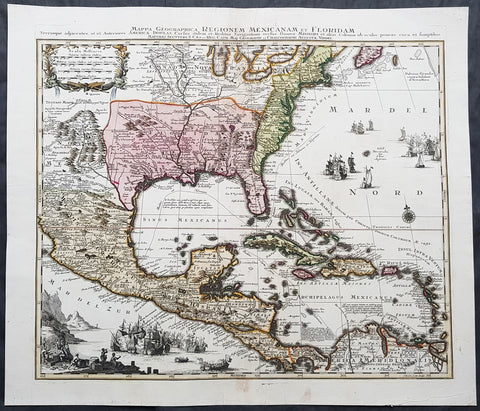
1730 Matthaus Seutter Large Antique Map of British, French Spanish North America
- Title : Mappa Geographica Regionem Mexicanam et Floridam. Terrasque adjacentes ut et Anteriors Americae Insulas Cursus itidem et Reditus Navigantium versus flumen Missisipi et alais Colonias ob oculos ponens eura et sumptibus Matthaei Seutteri S. Caes et Reg Cath Maj, Geograph et Chalcographi Augustae Vindel...Tob. Con. Lotter Sculps
- Date : 1730
- Condition: (A) Very Good Condition
- Ref: 42019
- Size: 25 1/2in x 22in (650mm x 560mm)
Description:
This beautifully hand coloured original antique map is one of the best, engraved by Tobias Conrad Lotter and published by Matthaus Seutter in 1730.
One of the best and most beautifully executed, iconic 18th century antique maps of colonial North America. Engraved after the 1703 map of North America by Guillaume Delisle, it was re-issued by a number of famous 18th century cartographers.
The ongoing and the changing ownership of North America is illustrated in the specific demarcation of the British, French and Spanish regions. To the right & bottom left of the map is illustrated using naval battles, with the various ships flying the British, French & Spanish flags.
This map is a must for any North American collection, with beautiful original hand colour, a heavy impression (denoting an early pressing) on heavy sturdy paper with original margins, an exciting map .
General Definitions:
Paper thickness and quality: - Heavy and stable
Paper color : - off white
Age of map color: - Original
Colors used: - Yellow, green, blue, pink
General color appearance: - Authentic
Paper size: - 25 1/2in x 22in (650mm x 560mm)
Plate size: - 23in x 19 3/4in (585mm x 500mm)
Margins: - Min 1in (25mm)
Imperfections:
Margins: - None
Plate area: - Light discolouration to Nova Francia around great lakes
Verso: - Backed onto archival tissue, centerfold re-enforced
Background:
The importance of this landmark map of North America cannot be overstated. It was the first map to accurately depict the course and mouth of the Mississippi River. Much of the map was drawn from reports brought back to France from the survivor\\\'s of the La Salle expedition into the interior of North America and from information derived from the explorations of Bienville and d Iberville. In the year preceding the publication of the map, Delisle utilised his position with the King of France to gain access to the best available information from the new world.
During this time, he compiled the geographical data from the reports of the French Jesuit Missionaries and explorers in North America, along with Spanish manuscript maps (often copied by the Missionaries while they were acting in the service of the Spanish as spiritual guides and gaining their confidence). The result of this work were a series of 4 landmark maps of America, including his map of North America (L Amerique Septentrionale, 1700), Canada and the Great Lakes (Carte du Canada ou de la Nouvelle France 1703) and the Mississippi Valley & Gulf Coast (Carte de la Louisiane et du Cours du Mississipi 1708) and of course this map.
Carl Wheat called this map a towering landmark along the path of Western cartographic development. This map also included greater accuracy in the Great Lakes region and in its depiction of English settlements along the East Coast. Excellent detail of the Indian villages in East Texas, based upon the reports of Iberville and the Spanish missionaries. The best depiction of the Southwest to date, with early trails & Indian tribes. Cumming described the map as profoundly influential. (Ref: Cummings; M&B; Tooley)
Seutter, Matthaus 1678 - 1757
Seutter was one of the most important and prolific German map publishers of the 18th century. Seutter started his career as an apprentice brewer. Apparently uninspired by the beer business, Seutter left his apprenticeship and moved to Nuremberg where he apprenticed as an engraver under the tutelage of the prominent J. B. Homann. Sometime in the early 18th century Seutter left Homann to establish his own independent cartographic publishing firm in Augsburg. Though he struggled in the early years of his independence, Seutters engraving skill and commitment to diversified map production eventually gained him a substantial following. Most of Seutters maps were heavily based upon, if not copies of, earlier work done by the Homann and Delisle firms.
By 1732 Seutter was one of the most prolific publishers of his time and was honored by the German Emperor Charles VI with the title of Imperial Geographer. Seutter continued to publish until his death, at the height of his career, in 1757. The Seutter firm continued under Seutters wastrel son Albrecht Carl until his death in 1762. Following Albrechts death, the firm was divided between the established Probst firm and the emerging firm of Tobias Conrad Lotter. Lotter, Seutters son in law, was a master engraver and worked on behalf of the Seutter firm. Lotter would eventually become one of the most prominent cartographers of his day.
Please note all items auctioned are genuine, we do not sell reproductions. A Certificate of Authenticity (COA) can be issued on request.
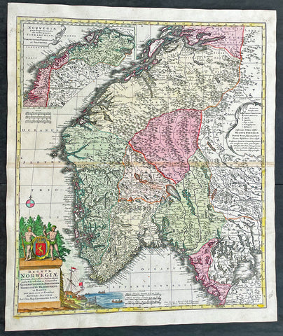
1730 Matthaus Seutter Large Antique Map of Norway
- Title : Regnum Norwegiae...Matthaei Seutteri
- Ref #: 17020
- Size: 24 1/2in x 21in (630mm x 530mm)
- Date : 1730
- Condition: (A+) Fine Condition
Description:
This large original beautifully hand coloured antique map of Norway was published by Georg Mattraus Seutter in 1730.
General Definitions:
Paper thickness and quality: - Heavy and stable
Paper color : - off white
Age of map color: - Original
Colors used: - Yellow, brown, pink, red, blue
General color appearance: - Authentic
Paper size: - 24 1/2in x 21in (630mm x 530mm)
Plate size: - 23 1/2in x 19 1/2in (590mm x 500mm)
Margins: - Min 1/2in (12mm)
Imperfections:
Margins: - None
Plate area: - Light toning along centerfold
Verso: - None
Background:
Before the fifteenth century the peoples of Southern Europe had little geographical knowledge of the Scandinavian world except from sketchy detail shown in the Catalan Atlas (1375) and on a number of \'portolani\' embracing Denmark and the southern tip of Norway. It was not until 1427 that a manuscript map prepared about that time by Claudius Clavus (b. 1388), a Dane who had spent some time in Rome, made available to scholars a tolerable outline of the northern countries and Greenland. That was to remain the best map available for the rest of the century and it was used as the basis for maps of Scandinavia in early printed editions of Ptolemy. Others by Nicolaus Cusanus (1491) and Ehrhard Etzlaub (c. 1492) followed but, needless to say, these are extremely rare; even the later maps by Olaus Magnus and Marcus Jordan, where they have survived at all, are known only by very few examples. In fact, apart from the rare appearance of an early Ptolemy map, the oldest of Scandinavia which a collector is likely to find are those in Munster\'s Cosmography published in 1544 with many later editions. In the following centuries the comparatively few maps and charts compiled in Scandinavia were usually published in Amsterdam, Antwerp, Paris or Nuremberg, the more important maps often being incorporated in the major Dutch, French and German atlases. (Ref: Tooley; M&B)
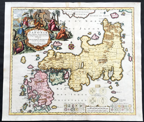
1730 Seutter Large Antique Map of Japan after Kaempfer - Regni Japoniae
- Title : Regni Japoniae Nova Mappa Geographica, ex indigenarum observationibus delineata ab Engelberto Kaempfero
- Date : 1730
- Condition: (A+) Fine Condition
- Ref: 43154
- Size: 24in x 21in (610mm x 530mm)
Description:
This large beautifully hand coloured original antique map of Japan engraved by TC Lotter - after Engebert Kaempfer - was published by Georg Mattraus Seutter in 1730.
Condition Report
Paper thickness and quality: - Heavy and stable
Paper color: - off white
Age of map color: - Original & later
Colors used: - Yellow, pink, green, orange, blue
General color appearance: - Authentic
Paper size: - 24in x 21in (610mm x 530mm)
Plate size: - 22 1/2in x 19 ½in (570mm x 495mm)
Margins: - Min 1in (25mm)
Imperfections:
Margins: - Light soiling
Plate area: - Small repair adjacent to bottom centerfold, no loss
Verso: - None
Background: This beautiful map owes its cartography to a map by Engebert Kaempfer from his important publication History of Japan, based on his travels to Japan in the late 17th century and his own manuscript map, drawn sometime prior to 1716. The map presents a distorted outline for the Island of Japan with numerous political divisions delineated and named. Below the map are numerous Japanese coins and symbols including those of the army of Japan's "Prince". The entire upper left quadrant is filled with a spectacular title cartouche showing a court scene of Kaempfer presenting maps to the Japanese Emperor and other attendants.
Engelbert Kaempfer (September 16, 1651 – November 2, 1716) was a German naturalist and physician known for his tour of Russia, Persia, India, South-East Asia, and Japan between 1683 and 1693. He wrote two books about his travels. Amoenitatum Exoticarum, published in 1712, is important for its medical observations and the first extensive description of Japanese plants (Flora Japonica). His History of Japan, published posthumously in 1727, was the chief source of Western knowledge about the country throughout the 18th century.(Ref: M&B; Tooley)
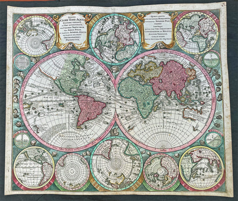
1740 Georg Seutter Large Antique Twin Hemisphere World Map - Beautiful
- Title : Diversi Globi Terr-Aquei Statione Variante Et Visu Intercedente, Per Coluros Tropicorum, Per Ambos Polos Et Particul. Sphaerae Zenith In Planum Delineati Orthographici Prospectus ; Quibus Additae Pro Mutatione Horizontis Differentes Sphaerae Positiones Earumque Mutua Cum Circ. Coelestibus Convenientia Et Relatio Augustae Vindelicor. Cura Et Studio Matth. Seutteri, S.C. Maj. Geogr.
- Ref #: 17004
-
Condition: (A+) Fine Condition
- Size: 24in x 21 1/2in (610mm x 545mm)
- Date : 1740
- Price: $2,750.00US
Description:
This original beautifully hand coloured large antique Twin Hemisphere World map was published by the German publisher Georg Matthaus Seutter in ca 1740.
This is a magnificent map, beautifully hand coloured in superb condition, a great addition to any collection.
General Definitions:
Paper thickness and quality: - Heavy and stable
Paper color : - off white
Age of map color: - Original
Colors used: - Yellow, green, blue, pink
General color appearance: - Authentic
Paper size: - 24in x 21 1/2in (610mm x 545mm)
Plate size: - 23in x 19 3/4in (585mm x 500mm)
Margins: - Min 1/2in (12mm)
Imperfections:
Margins: - Light soiling in margins
Plate area: - None
Verso: - Re-enforced along centerfold
Background:
This map, of two central hemispheres, is surrounded by eight smaller, circular projections depicting the world from various orientations, as well as four circular scientific diagrams.
The projection on the left shows the Western Hemisphere. In North America, California is depicted as an island, and a vast northwestern coast, Terra Essonis, stretches off the map. In the South Pacific, a partial coastline can be seen for New Zealand and a large block of text explains the ecliptic and the constellations that lie along that line, the signs of the Zodiac.
The projection on the right shows the Eastern Hemisphere, with an easily-recognizable Europe and Africa; Asias eastern coastline is oddly smoothed and shortened. A distorted Japan has been fused with the conjectural landmass Terra Yedso. Compared to Allards map, the graticule is shifted east; that is, more of Oceania is included in this hemisphere, rather than in the western hemisphere.
Partial coastlines for Australia (Nova Hollandia), New Guinea, and surrounding lands are depicted in the Pacific. The shores of Australia are based on early Dutch encounters with the northern and western coastlines, and place names on the western coast are marked with their years of discovery. The Southern Atlantic and Indian Oceans remain conspicuously empty, noted only as Terra Australis Incognita, or unknown southern land, a departure from the grandiose southern continents often seen on earlier and even contemporary world maps.
Dotted lines crisscrossing both hemispheres, not present in Allards original map, trace important voyages of European encounter. One line traces Ferdinand Magellans quest to find a westward route to the Spice Islands via the southern tip of South America, departing Malaga, Spain, in August 1519, and returning (after the death of Magellan and much of the crew) in September 1522. Another important voyage traced is that of Abel Tasman in 1642 to Oceania, including observation of parts of the Australian coastline and the first European encounter with New Zealand.
In the top and lower center of the map, smaller circular projections depict the Northern and Southern Hemispheres. Seutter, like Allard before him, has chosen to leave the South Pole empty, rather than fill it with hypothetical beaches and lands. Two small polar projections appear at the bottom of the map. Four small circular scientific diagrams are depicted at the outer corners of the twin hemispheres. The diagram in the upper left depicts lines of latitude and longitude, while the diagrams in the other three corners show the relationship between the zenith, the nadir, and different horizons.
Circular projections in the four corners of the map show the world from slightly different, oblique or optical orientations. These allow viewers to understand which landmasses are antipodal to certain points. The figure in the upper left shows the antipodes of Amsterdam, with Amsterdam on the hemisphere in the upper right corner (this is stated explicitly in Allards map of 1696, but is merely implied here.) The two hemispheres in the bottom corners show the world as if in 3-D, with the meridians curved to show the world as round, rather than flattened as many map projections do.
Finally, there are several decorative features in the map. While the map lacks the lushly illustrated border scenes common in maps of the previous century, it incorporates more decorative detail than the Allard map it is based on. Surrounding the map, twelve wind heads peer out from the darkness, based upon the twelve classical wind heads from antiquity. The two cartouches at the top of the map add further decorative flourishes.
The present map appeared in the first edition of Seutters Atlas Novus sive Tabulae Geographicae, first published in Augsburg in 1720. As stated above, this map is based on Carel Allards 1696 double-hemisphere world map. Similar maps were produced by fellow eighteenth-century mapmakers such as Pieter Schenk, Adam Friedrich Zürner, and Johann Homann.
The present map contains several noteworthy features in the Pacific Ocean. Australia is less accurately depicted than in Allards map; it is suggestively connected to surrounding landmasses with incomplete coastlines. Carpentaria, named for Pieter de Carpentier, governor-general (1623–27) of the Dutch East Indies extends toward New Guinea.
North of Carpentaria is Nova Britania, and a note indicates it was discovered by English buccaneer William Dampier, who explored the north and west coasts of Australia in 1688 and 1699. Dampier was a buccaneer, pilot, and natural historian who was also the first person to circumnavigate the world three times.
South of Australia is Diemens Land, named by Abel Tasman for his commander, Anthony van Diemen, governor-general (1636–45) of the Dutch East Indies. In the lower left of the left projection, the incomplete coastline of New Zealand also references Abel Tasman. Anthony van Diemen is again honored here, with Cape Maria van Diemen being named by Tasman after van Diemens wife. Unlike in Allards map, Quiri Regio, named after Portuguese explorer Pedro Fernandes de Quiros and corresponding to present-day Vanuatu, is not present.
The northern Pacific also includes interesting geographic elements, reflective of information gleaned from the 1643 voyage of Maarten Gerritszoon de Vries, a Dutch explorer for the VOC. De Vries is credited with charting islands and promontories north of Japan, which were then believed to be part of America. In the right projection, an enlarged Hokkaido is clearly labeled as Yedso and is connected to the misshapen Japanese mainland. Unlike in Allards map, Yedso does not stretch east to connect to Terra Essonis, the vast, empty expanse of land stretching westward off of North America. Interestingly, though, Terra Essonis does appear connected to Yedso and Japan in the smaller projections on either side of the right cartouche at the top of the map, and second to right at the bottom. These smaller projections match Allards depiction.
The origin of Terra Essonis is tangled with that of Compagnie Land, a conjectural landmass not depicted in Allards map. In 1589, Portuguese explorer João da Gama fled the East Indies to escape sentencing for illegally trading oriental silks with the Spanish for South American gold. Sailing east, da Gama reported the existence of an uninterrupted coast northeast of Japan stretching from Asia to North America. A dotted line tracing da Gamas voyage runs along the coast of Terra Essonis.
Da Gamas claim was also sometimes depicted on maps as a series of islands or a landmass called Gamaland. Gamaland was searched for by several explorers, including the aforementioned Maarten Gerritszoon de Vries in 1643. While searching for Gamaland, de Vries found two new islands—Compagnie Land (named in honor of the Dutch East Indies Company) and Staaten Land (named after the Dutch States General). These islands correspond to Iturup and Urup, part of the volcanic Kuril Islands in the Sea of Okhotsk. Compagnie Land was sometimes taken as proof of the existence of Gamaland, and, along with Terra Essonis, continued to appear on maps long after da Gamas death in ca. 1592, as evidenced by this map created more than a century later.
As far as evidence of the fabled Northwest Passage linking Europe to Asia above or across North America, this map portrays the Fretum Anian (Straits of Anian) separating Terra Essonis and California, but it does not depict where the straits lead to in the north. The Straits of Anian were believed to mark the separation between Asia and North America, which would be disproven in the mid-eighteenth century with the discovery of the Bering Strait.
Another noteworthy detail in the present map is the island of California, which can be seen on four of the eight projections. From its first portrayal on a printed map by Diego Gutiérrez, in 1562, California was shown as part of North America by mapmakers, including Gerardus Mercator and Ortelius. In the 1620s, however, it began to appear as an island in several sources.
This was most likely the result of a reading of the travel account of Sebastian Vizcaino, who had been sent north up the shore of California in 1602. A Carmelite friar who accompanied him later described the land as an island, a description first published in Juan Torquemadas Monarquia Indiana (1613) with the island details curtailed somewhat. The friar, Fray Antonio de la Ascension, also wrote a Relacion breve of his geographic ideas around 1620. The ideas spread about New Spain and, eventually, most likely via Dutch mariners and perhaps thanks to stolen charts, to the rest of Europe.
By the 1620s, many mapmakers chose to depict the peninsula as an island. These included Henricus Hondius, who published the first atlas map to focus solely on North America with the island prominently featured in 1636. Hondius borrowed his outline of California from another widely distributed map, that of Henry Briggs and printed in Samuel Purchas Hakluytus Posthumus or Purchas his Pilgrimes (1625). Other prominent practitioners like John Speed and Nicolas Sanson also adopted the new island and the practice became commonplace.
Father Eusebio Kino initially followed along with this theory, but after extensive travels in what is now California, Arizona, and northern Mexico, he concluded that the island was actually a peninsula. Even after Kino published a map based on his travels refuting the claim (Paris, 1705), California as an island remained a fixture until the mid-eighteenth century, as can be seen in the present map.
This dynamic map displays a unique combination of scientific information and decorative imagery, portraying updated geographic information based on exploration while still incorporating on conjecture and decorative elements.
Please note all items auctioned are genuine, we do not sell reproductions. A Certificate of Authenticity (COA) can be issued on request.
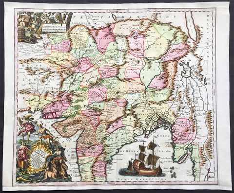
1740 Seutter Large Antique Map of India, Mughal Empire, Tibet, Nepal
- Title : Imperii Magni Mogolis sive Indici Padschach, juxta recentiissimas Navigationes accurata delineato Geographica studio et sumtibus.
- Date : 1740
- Condition: (A+) Fine Condition
- Ref: 42008
- Size: 25in x 20 1/2in (630mm x 520mm)
Description:
This large beautifully hand coloured original antique map of India and the Northern Mughal Empire was published by Georg Mattraus Seutter in 1740.
Background:
Representing 18th century Germany cartography at it’s finest; this is an absolutely spectacular c. 1740 map of northern India by Matthias Seutter. Showing the extent of the powerful Mughal Empire in the late 17th century, this map details the subcontinent and parts of Central Asia from Persia and Khandhar eastward as far a modern day Burma and Thailand. Extends northward to include parts of Tibet and Nepal and southwards as far as the Malabar Coast and the Gulf of Thailand. Cartographically this map is heavily based upon Hondius and Mercator’s 17th century of the same region entitled India Orientalis. Presented is wonderful combination of surprising accuracy, gross errors, and outright speculation. Generally speaking, this map is cartographically solid detailing numerous cities, river systems and trade routes. Shows Deli, Agra, Kandahar (Candahar), Lahore (Lahor), Pegu, Goa, Kabul (Cabul), Jaisalmer (Gislemere), and many other important and still thriving cities. Also notes several important trade routes including the ancient caravan trail westward from Agra into Persia. Despite this map’s thoroughness, there are a number of cartographic errors, probably the most notable of which is the narrowing of the subcontinent. Usually such lateral misrepresentations are the result of erroneous 16th century longitudinal calculations. In this case, these errors found their way into the Hondius’s map and hence into this one as well. The northernmost regions depicted on this map are highly speculative with regard to physical geography. A number of large lakes, including the apocryphal Lake of Chiamay, are speculated in the northeastern quadrants of the map as the sources of four important Southeast Asian river systems including the Irrawaddy, the Dharla, the Chao Phraya, and the Brahmaputra. The curious Lake of Chiamay (also called Chiam-may or Chian-may), roughly located in the area of Assam but sometimes as far north as Tibet and China, began to appear in maps of this region as early as the 16th century and persisted well into the mid 18th century. Its origins are unknown but may originate in a lost 16th century geography prepared by the Portuguese scholar Jao de Barros. It was speculated to be the source of five important Southeast Asian River systems and was mentioned in the journals of Sven Hedin. There are even records that the King of Siam led an invasionary force to take control of the lake in the 16th century. Nonetheless, the theory of Lake Chimmay was ultimately disproved and it disappeared from maps entirely by the 1760s. Decorated with several extremely attractive allegorical cartouche image. The title cartouche in the lower left hand quadrant shows Poseidon, Hermes, an angel and the goddess Fame admiring the wealth of Asia as represented by jewels, ivory, and precious metals. In the upper left hand quadrant, a distance scale plays second fiddle to a scene of cherubs rummaging through chests full of treasure while exotic peacocks look on. A large trade Caravel rests in the Indian Ocean, lower right quadrant, suggesting the trade riches to be had by daring ship captains willing to sail half way around the world. Engraved by Albrecht Carl Seutter and published by Matthias Seutter c. 1740. (Ref: M&B; Tooley)
Condition Report
Paper thickness and quality: - Heavy and stable
Paper color: - off white
Age of map color: - Original & later
Colors used: - Yellow, pink, green, orange, blue
General color appearance: - Authentic
Paper size: - 25in x 20 1/2in (630mm x 520mm)
Plate size: - 22 1/2in x 20in (570mm x 500mm)
Margins: - Min 1/2in (12mm)
Imperfections:
Margins: - Bottom & top margin extended from plate-mark & border
Plate area: - None
Verso: - None
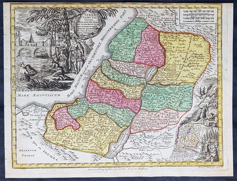
1744 Georg Mattaus Seutter Antique Map Holy Land, Palestine, Israel, XII Tribes
- Title : Terra Sancta vocata Quae, Olim XII Tribes........a Matth. Seutteri...T C Lotter, Geogr.
- Ref #: 93403
- Size: 11in x 8 1/2in (280mm x 215mm)
- Date : 1744
- Condition: (A+) Fine Condition
Description:
This beautifully hand coloured original copper-plate engraved antique map of The Holy Land was engraved by Tobias Lotter and was published in the 1744 edition of GM Seutters Atlas Minor Prae cipua Orbis Terrarum Imperia Regna et Provincias...., Augsburg, Germany.
General Definitions:
Paper thickness and quality: - Heavy and stable
Paper color : - off white
Age of map color: - Original
Colors used: - Yellow, green, blue, pink
General color appearance: - Authentic
Paper size: - 11in x 8 1/2in (280mm x 215mm)
Plate size: - 10 1/2in x 8in (265mm x 205mm)
Margins: - Min 1/4in (5mm)
Imperfections:
Margins: - None
Plate area: - None
Verso: - None
Background:
Atlas Minor was a series of beautiful maps of all parts of the world. Georg Matthäus Seutter was one of the most and important of the German cartographers of the 18th century, being appointed as the Geographer to the Imperial Court. His son, Albrecht Carl, joined Matthäus and eventually inherited the business. The maps from Atlas Minor were drawn by the two Seutters and engraved by Tobias Conrad Lotte. These maps are highly detailed and engraved with a bold hand with equally strong original hand color in the body of the map as was the 18th century German style. The cartouches were left uncolored in order to emphasize the elaborately detailed illustrations for which German maps are especially prized. These are some of the most decorative and interesting maps of the eighteenth century.
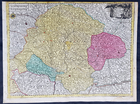
1744 Georg Mattaus Seutter Antique Map Hungarian Empire, Transylvania, Sclavonia
- Title : Regni Hungariae........a Matth. Seutteri...T C Lotter, Geogr.
- Ref #: 93399
- Size: 11in x 8 1/2in (280mm x 215mm)
- Date : 1744
- Condition: (A) Very Good Condition
Description:
This beautifully hand coloured original copper-plate engraved antique map of the Hungarian Empire was engraved by Tobias Lotter and was published in the 1744 edition of GM Seutters Atlas Minor Prae cipua Orbis Terrarum Imperia Regna et Provincias...., Augsburg, Germany.
General Definitions:
Paper thickness and quality: - Heavy and stable
Paper color : - off white
Age of map color: - Original
Colors used: - Yellow, green, blue, pink
General color appearance: - Authentic
Paper size: - 11in x 8 1/2in (280mm x 215mm)
Plate size: - 10 1/2in x 8in (265mm x 205mm)
Margins: - Min 1/4in (5mm)
Imperfections:
Margins: - Top margin cropped into border
Plate area: - None
Verso: - None
Background:
Atlas Minor was a series of beautiful maps of all parts of the world. Georg Matthäus Seutter was one of the most and important of the German cartographers of the 18th century, being appointed as the Geographer to the Imperial Court. His son, Albrecht Carl, joined Matthäus and eventually inherited the business. The maps from Atlas Minor were drawn by the two Seutters and engraved by Tobias Conrad Lotte. These maps are highly detailed and engraved with a bold hand with equally strong original hand color in the body of the map as was the 18th century German style. The cartouches were left uncolored in order to emphasize the elaborately detailed illustrations for which German maps are especially prized. These are some of the most decorative and interesting maps of the eighteenth century.
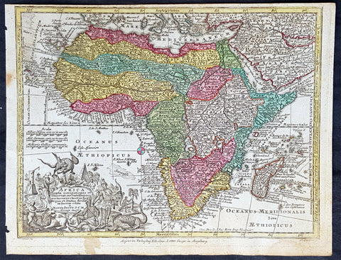
1744 Georg Mattaus Seutter Antique Map of Africa
- Title : Africa a Matth. Seutteri...T C Lotter, Geogr.
- Ref #: 93390
- Size: 11in x 8 1/2in (280mm x 215mm)
- Date : 1744
- Condition: (A+) Fine Condition
Description:
These beautifully hand coloured original copper-plate engraved antique map was engraved by Tobias Lotter and published in the 1744 edition of GM Seutters Atlas Minor Prae cipua Orbis Terrarum Imperia Regna et Provincias...., Augsburg, Germany.
General Definitions:
Paper thickness and quality: - Heavy and stable
Paper color : - off white
Age of map color: - Early
Colors used: - Yellow, green, blue, pink
General color appearance: - Authentic
Paper size: - 11in x 8 1/2in (280mm x 215mm)
Plate size: - 10 1/2in x 8in (265mm x 205mm)
Margins: - Min 1/4in (5mm)
Imperfections:
Margins: - Age toning to margins
Plate area: - None
Verso: - None
Background:
Atlas Minor was a series of beautiful maps of all parts of the world. Georg Matthäus Seutter was one of the most and important of the German cartographers of the 18th century, being appointed as the Geographer to the Imperial Court. His son, Albrecht Carl, joined Matthäus and eventually inherited the business. The maps from Atlas Minor were drawn by the two Seutters and engraved by Tobias Conrad Lotte. These maps are highly detailed and engraved with a bold hand with equally strong original hand color in the body of the map as was the 18th century German style. The cartouches were left uncolored in order to emphasize the elaborately detailed illustrations for which German maps are especially prized. These are some of the most decorative and interesting maps of the eighteenth century.
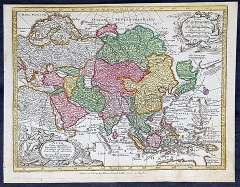
1744 Georg Mattaus Seutter Antique Map of Asia
- Title : Asia a Matth. Seutteri...T C Lotter, Geogr.
- Ref #: 93389
- Size: 11in x 8 1/2in (280mm x 215mm)
- Date : 1744
- Condition: (A+) Fine Condition
Description:
These beautifully hand coloured original copper-plate engraved antique map was engraved by Tobias Lotter and published in the 1744 edition of GM Seutters Atlas Minor Prae cipua Orbis Terrarum Imperia Regna et Provincias...., Augsburg, Germany.
General Definitions:
Paper thickness and quality: - Heavy and stable
Paper color : - off white
Age of map color: - Early
Colors used: - Yellow, green, blue, pink
General color appearance: - Authentic
Paper size: - 11in x 8 1/2in (280mm x 215mm)
Plate size: - 10 1/2in x 8in (265mm x 205mm)
Margins: - Min 1/4in (5mm)
Imperfections:
Margins: - None
Plate area: - None
Verso: - None
Background:
Atlas Minor was a series of beautiful maps of all parts of the world. Georg Matthäus Seutter was one of the most and important of the German cartographers of the 18th century, being appointed as the Geographer to the Imperial Court. His son, Albrecht Carl, joined Matthäus and eventually inherited the business. The maps from Atlas Minor were drawn by the two Seutters and engraved by Tobias Conrad Lotte. These maps are highly detailed and engraved with a bold hand with equally strong original hand color in the body of the map as was the 18th century German style. The cartouches were left uncolored in order to emphasize the elaborately detailed illustrations for which German maps are especially prized. These are some of the most decorative and interesting maps of the eighteenth century.
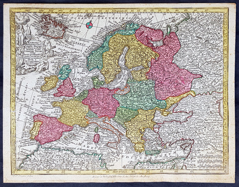
1744 Georg Mattaus Seutter Antique Map of Europe
- Title : Europa a Matth. Seutteri...T C Lotter, Geogr.
- Ref #: 93388
- Size: 11in x 8 1/2in (280mm x 215mm)
- Date : 1744
- Condition: (A+) Fine Condition
Description:
These beautifully hand coloured original copper-plate engraved antique map was engraved by Tobias Lotter and published in the 1744 edition of GM Seutters Atlas Minor Prae cipua Orbis Terrarum Imperia Regna et Provincias...., Augsburg, Germany.
General Definitions:
Paper thickness and quality: - Heavy and stable
Paper color : - off white
Age of map color: - Early
Colors used: - Yellow, green, blue, pink
General color appearance: - Authentic
Paper size: - 11in x 8 1/2in (280mm x 215mm)
Plate size: - 10 1/2in x 8in (265mm x 205mm)
Margins: - Min 1/4in (5mm)
Imperfections:
Margins: - None
Plate area: - None
Verso: - None
Background:
Atlas Minor was a series of beautiful maps of all parts of the world. Georg Matthäus Seutter was one of the most and important of the German cartographers of the 18th century, being appointed as the Geographer to the Imperial Court. His son, Albrecht Carl, joined Matthäus and eventually inherited the business. The maps from Atlas Minor were drawn by the two Seutters and engraved by Tobias Conrad Lotte. These maps are highly detailed and engraved with a bold hand with equally strong original hand color in the body of the map as was the 18th century German style. The cartouches were left uncolored in order to emphasize the elaborately detailed illustrations for which German maps are especially prized. These are some of the most decorative and interesting maps of the eighteenth century.
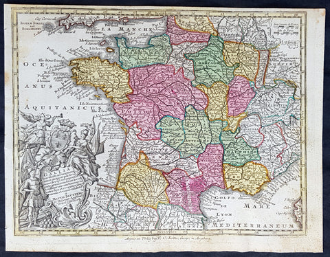
1744 Georg Mattaus Seutter Antique Map of France
- Title : Gallia....a Matth. Seuttero...T C Lotter, Geogr.
- Ref #: 93393
- Size: 11in x 8 1/2in (280mm x 215mm)
- Date : 1744
- Condition: (A+) Fine Condition
Description:
This beautifully hand coloured original copper-plate engraved antique map of France was engraved by Tobias Lotter and was published in the 1744 edition of GM Seutters Atlas Minor Prae cipua Orbis Terrarum Imperia Regna et Provincias...., Augsburg, Germany.
General Definitions:
Paper thickness and quality: - Heavy and stable
Paper color : - off white
Age of map color: - Original
Colors used: - Yellow, green, blue, pink
General color appearance: - Authentic
Paper size: - 11in x 8 1/2in (280mm x 215mm)
Plate size: - 10 1/2in x 8in (265mm x 205mm)
Margins: - Min 1/4in (5mm)
Imperfections:
Margins: - Light age toning
Plate area: - Light age toning
Verso: - None
Background:
Atlas Minor was a series of beautiful maps of all parts of the world. Georg Matthäus Seutter was one of the most and important of the German cartographers of the 18th century, being appointed as the Geographer to the Imperial Court. His son, Albrecht Carl, joined Matthäus and eventually inherited the business. The maps from Atlas Minor were drawn by the two Seutters and engraved by Tobias Conrad Lotte. These maps are highly detailed and engraved with a bold hand with equally strong original hand color in the body of the map as was the 18th century German style. The cartouches were left uncolored in order to emphasize the elaborately detailed illustrations for which German maps are especially prized. These are some of the most decorative and interesting maps of the eighteenth century.
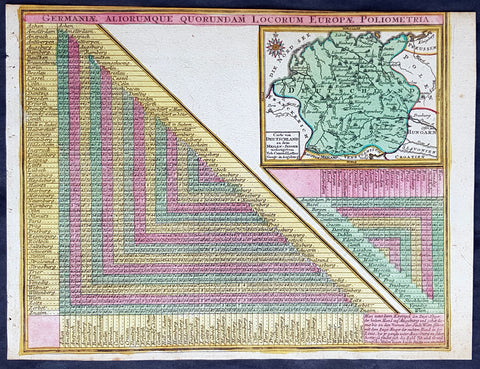
1744 Georg Mattaus Seutter Antique Map of Germany w/ European City Mileage Chart
- Title : Germaniae Aliorumque Quorundam Locorum Europae Poliometria....Cart von Deutsschland...Tob. Conrad Lotter Geogr.
- Ref #: 93404
- Size: 11in x 8 1/2in (280mm x 215mm)
- Date : 1744
- Condition: (A+) Fine Condition
Description:
This beautifully hand coloured original copper-plate engraved antique map of Germany, with a mileage index chart with all the major cities of Europe, was engraved by Tobias Lotter and was published in the 1744 edition of GM Seutters Atlas Minor Prae cipua Orbis Terrarum Imperia Regna et Provincias...., Augsburg, Germany.
General Definitions:
Paper thickness and quality: - Heavy and stable
Paper color : - off white
Age of map color: - Original
Colors used: - Yellow, green, blue, pink
General color appearance: - Authentic
Paper size: - 11in x 8 1/2in (280mm x 215mm)
Plate size: - 10 1/2in x 8in (265mm x 205mm)
Margins: - Min 1/4in (5mm)
Imperfections:
Margins: - Light age toning
Plate area: - Light age toning
Verso: - None
Background:
Atlas Minor was a series of beautiful maps of all parts of the world. Georg Matthäus Seutter was one of the most and important of the German cartographers of the 18th century, being appointed as the Geographer to the Imperial Court. His son, Albrecht Carl, joined Matthäus and eventually inherited the business. The maps from Atlas Minor were drawn by the two Seutters and engraved by Tobias Conrad Lotte. These maps are highly detailed and engraved with a bold hand with equally strong original hand color in the body of the map as was the 18th century German style. The cartouches were left uncolored in order to emphasize the elaborately detailed illustrations for which German maps are especially prized. These are some of the most decorative and interesting maps of the eighteenth century.

1744 Georg Mattaus Seutter Antique Map of Germany, Central & NW Europe
- Title : Imperium Romano Germanicum........a Matth. Seutteri...T C Lotter, Geogr.
- Ref #: 93398
- Size: 11in x 8 1/2in (280mm x 215mm)
- Date : 1744
- Condition: (A+) Fine Condition
Description:
This beautifully hand coloured original copper-plate engraved antique map of Germany and NW Europe was engraved by Tobias Lotter and was published in the 1744 edition of GM Seutters Atlas Minor Prae cipua Orbis Terrarum Imperia Regna et Provincias...., Augsburg, Germany.
General Definitions:
Paper thickness and quality: - Heavy and stable
Paper color : - off white
Age of map color: - Original
Colors used: - Yellow, green, blue, pink
General color appearance: - Authentic
Paper size: - 11in x 8 1/2in (280mm x 215mm)
Plate size: - 10 1/2in x 8in (265mm x 205mm)
Margins: - Min 1/4in (5mm)
Imperfections:
Margins: - Light age toning
Plate area: - Light age toning
Verso: - None
Background:
Atlas Minor was a series of beautiful maps of all parts of the world. Georg Matthäus Seutter was one of the most and important of the German cartographers of the 18th century, being appointed as the Geographer to the Imperial Court. His son, Albrecht Carl, joined Matthäus and eventually inherited the business. The maps from Atlas Minor were drawn by the two Seutters and engraved by Tobias Conrad Lotte. These maps are highly detailed and engraved with a bold hand with equally strong original hand color in the body of the map as was the 18th century German style. The cartouches were left uncolored in order to emphasize the elaborately detailed illustrations for which German maps are especially prized. These are some of the most decorative and interesting maps of the eighteenth century.
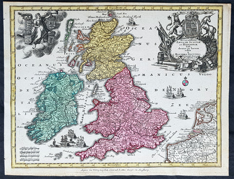
1744 Georg Mattaus Seutter Antique Map of Great Britain & Ireland - Scotland et.
- Title : Accuratissima Angliae, Scotiae ei Hiberniae........a Matth. Seutteri...T C Lotter, Geogr.
- Ref #: 93394
- Size: 11in x 8 1/2in (280mm x 215mm)
- Date : 1744
- Condition: (A+) Fine Condition
Description:
This beautifully hand coloured original copper-plate engraved antique map of Great Britain & Ireland was engraved by Tobias Lotter and was published in the 1744 edition of GM Seutters Atlas Minor Prae cipua Orbis Terrarum Imperia Regna et Provincias...., Augsburg, Germany.
General Definitions:
Paper thickness and quality: - Heavy and stable
Paper color : - off white
Age of map color: - Original
Colors used: - Yellow, green, blue, pink
General color appearance: - Authentic
Paper size: - 11in x 8 1/2in (280mm x 215mm)
Plate size: - 10 1/2in x 8in (265mm x 205mm)
Margins: - Min 1/4in (5mm)
Imperfections:
Margins: - None
Plate area: - None
Verso: - None
Imperfections:
Margins: - Top margin cropped into border
Plate area: - None
Verso: - None
Background:
Atlas Minor was a series of beautiful maps of all parts of the world. Georg Matthäus Seutter was one of the most and important of the German cartographers of the 18th century, being appointed as the Geographer to the Imperial Court. His son, Albrecht Carl, joined Matthäus and eventually inherited the business. The maps from Atlas Minor were drawn by the two Seutters and engraved by Tobias Conrad Lotte. These maps are highly detailed and engraved with a bold hand with equally strong original hand color in the body of the map as was the 18th century German style. The cartouches were left uncolored in order to emphasize the elaborately detailed illustrations for which German maps are especially prized. These are some of the most decorative and interesting maps of the eighteenth century.
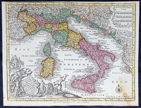
1744 Georg Mattaus Seutter Antique Map of Italy, Sicily Sardinia, Corsica
- Title : Nova Totius Italiae.......a Matth. Seutteri...T C Lotter, Geogr.
- Ref #: 93396
- Size: 11in x 8 1/2in (280mm x 215mm)
- Date : 1744
- Condition: (A+) Fine Condition
Description:
This beautifully hand coloured original copper-plate engraved antique map of Italy was engraved by Tobias Lotter and was published in the 1744 edition of GM Seutters Atlas Minor Prae cipua Orbis Terrarum Imperia Regna et Provincias...., Augsburg, Germany.
General Definitions:
Paper thickness and quality: - Heavy and stable
Paper color : - off white
Age of map color: - Early
Colors used: - Yellow, green, blue, pink
General color appearance: - Authentic
Paper size: - 11in x 8 1/2in (280mm x 215mm)
Plate size: - 10 1/2in x 8in (265mm x 205mm)
Margins: - Min 1/4in (5mm)
Imperfections:
Margins: - None
Plate area: - None
Verso: - Light age toning right bottom corner
Background:
Atlas Minor was a series of beautiful maps of all parts of the world. Georg Matthäus Seutter was one of the most and important of the German cartographers of the 18th century, being appointed as the Geographer to the Imperial Court. His son, Albrecht Carl, joined Matthäus and eventually inherited the business. The maps from Atlas Minor were drawn by the two Seutters and engraved by Tobias Conrad Lotte. These maps are highly detailed and engraved with a bold hand with equally strong original hand color in the body of the map as was the 18th century German style. The cartouches were left uncolored in order to emphasize the elaborately detailed illustrations for which German maps are especially prized. These are some of the most decorative and interesting maps of the eighteenth century.
1744 Georg Mattaus Seutter Antique Map of North America, California as Island
- Title : Nova Orbis sive America Septentrionalis a Matth. Seutteri...T C Lotter, Geogr.
- Ref #: 93405
- Size: 11in x 8 1/2in (280mm x 215mm)
- Date : 1744
- Condition: (A+) Fine Condition
Description:
These beautifully hand coloured original copper-plate engraved antique map was engraved by Tobias Lotter and published in the 1744 edition of GM Seutters Atlas Minor Prae cipua Orbis Terrarum Imperia Regna et Provincias...., Augsburg, Germany.
General Definitions:
Paper thickness and quality: - Heavy and stable
Paper color : - off white
Age of map color: - Early
Colors used: - Yellow, green, blue, pink
General color appearance: - Authentic
Paper size: - 11in x 8 1/2in (280mm x 215mm)
Plate size: - 10 1/2in x 8in (265mm x 205mm)
Margins: - Min 1/4in (5mm)
Imperfections:
Margins: - None
Plate area: - None
Verso: - None
Background:
Atlas Minor was a series of beautiful maps of all parts of the world. Georg Matthäus Seutter was one of the most and important of the German cartographers of the 18th century, being appointed as the Geographer to the Imperial Court. His son, Albrecht Carl, joined Matthäus and eventually inherited the business. The maps from Atlas Minor were drawn by the two Seutters and engraved by Tobias Conrad Lotte. These maps are highly detailed and engraved with a bold hand with equally strong original hand color in the body of the map as was the 18th century German style. The cartouches were left uncolored in order to emphasize the elaborately detailed illustrations for which German maps are especially prized. These are some of the most decorative and interesting maps of the eighteenth century.
1744 Georg Mattaus Seutter Antique Map of Ottoman Empire Hungary to Saudi Arabia
- Title : Magni Turcarum Dominatoris Imperium........a Matth. Seutteri...T C Lotter, Geogr.
- Ref #: 93402
- Size: 11in x 8 1/2in (280mm x 215mm)
- Date : 1744
- Condition: (A+) Fine Condition
Description:
This beautifully hand coloured original copper-plate engraved antique map of The Ottoman Empire from Hungary to Saudi Arabia was engraved by Tobias Lotter and was published in the 1744 edition of GM Seutters Atlas Minor Prae cipua Orbis Terrarum Imperia Regna et Provincias...., Augsburg, Germany.
General Definitions:
Paper thickness and quality: - Heavy and stable
Paper color : - off white
Age of map color: - Original
Colors used: - Yellow, green, blue, pink
General color appearance: - Authentic
Paper size: - 11in x 8 1/2in (280mm x 215mm)
Plate size: - 10 1/2in x 8in (265mm x 205mm)
Margins: - Min 1/4in (5mm)
Imperfections:
Margins: - None
Plate area: - None
Verso: - None
Background:
Atlas Minor was a series of beautiful maps of all parts of the world. Georg Matthäus Seutter was one of the most and important of the German cartographers of the 18th century, being appointed as the Geographer to the Imperial Court. His son, Albrecht Carl, joined Matthäus and eventually inherited the business. The maps from Atlas Minor were drawn by the two Seutters and engraved by Tobias Conrad Lotte. These maps are highly detailed and engraved with a bold hand with equally strong original hand color in the body of the map as was the 18th century German style. The cartouches were left uncolored in order to emphasize the elaborately detailed illustrations for which German maps are especially prized. These are some of the most decorative and interesting maps of the eighteenth century.
1744 Georg Mattaus Seutter Antique Map of Poland, Lithuania & Baltic Countries
- Title : Polonia Regnum ul et Magni Ducat Lithuania........a Matth. Seutteri...T C Lotter, Geogr.
- Ref #: 93400
- Size: 11in x 8 1/2in (280mm x 215mm)
- Date : 1744
- Condition: (A+) Fine Condition
Description:
This beautifully hand coloured original copper-plate engraved antique map of Poland, Lithuania & the Baltic Countries was engraved by Tobias Lotter and was published in the 1744 edition of GM Seutters Atlas Minor Prae cipua Orbis Terrarum Imperia Regna et Provincias...., Augsburg, Germany.
General Definitions:
Paper thickness and quality: - Heavy and stable
Paper color : - off white
Age of map color: - Original
Colors used: - Yellow, green, blue, pink
General color appearance: - Authentic
Paper size: - 11in x 8 1/2in (280mm x 215mm)
Plate size: - 10 1/2in x 8in (265mm x 205mm)
Margins: - Min 1/4in (5mm)
Imperfections:
Margins: - None
Plate area: - None
Verso: - None
Background:
Atlas Minor was a series of beautiful maps of all parts of the world. Georg Matthäus Seutter was one of the most and important of the German cartographers of the 18th century, being appointed as the Geographer to the Imperial Court. His son, Albrecht Carl, joined Matthäus and eventually inherited the business. The maps from Atlas Minor were drawn by the two Seutters and engraved by Tobias Conrad Lotte. These maps are highly detailed and engraved with a bold hand with equally strong original hand color in the body of the map as was the 18th century German style. The cartouches were left uncolored in order to emphasize the elaborately detailed illustrations for which German maps are especially prized. These are some of the most decorative and interesting maps of the eighteenth century.
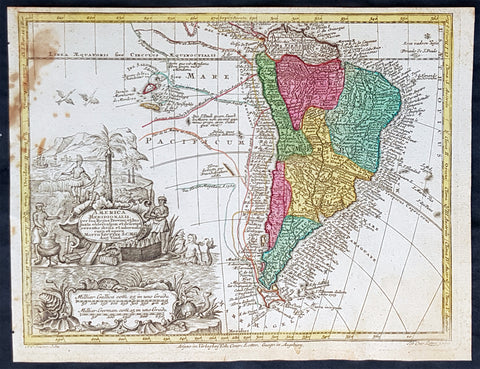
1744 Georg Mattaus Seutter Antique Map of South America
- Title : America Meridionalis a Matth. Seutteri...T C Lotter, Geogr.
- Ref #: 93391
- Size: 11in x 8 1/2in (280mm x 215mm)
- Date : 1744
- Condition: (A) Very Good Condition
Description:
These beautifully hand coloured original copper-plate engraved antique map was engraved by Tobias Lotter and published in the 1744 edition of GM Seutters Atlas Minor Prae cipua Orbis Terrarum Imperia Regna et Provincias...., Augsburg, Germany.
General Definitions:
Paper thickness and quality: - Heavy and stable
Paper color : - off white
Age of map color: - Early
Colors used: - Yellow, green, blue, pink
General color appearance: - Authentic
Paper size: - 11in x 8 1/2in (280mm x 215mm)
Plate size: - 10 1/2in x 8in (265mm x 205mm)
Margins: - Min 1/4in (5mm)
Imperfections:
Margins: - None
Plate area: - Age toning to left of image
Verso: - None
Background:
Atlas Minor was a series of beautiful maps of all parts of the world. Georg Matthäus Seutter was one of the most and important of the German cartographers of the 18th century, being appointed as the Geographer to the Imperial Court. His son, Albrecht Carl, joined Matthäus and eventually inherited the business. The maps from Atlas Minor were drawn by the two Seutters and engraved by Tobias Conrad Lotte. These maps are highly detailed and engraved with a bold hand with equally strong original hand color in the body of the map as was the 18th century German style. The cartouches were left uncolored in order to emphasize the elaborately detailed illustrations for which German maps are especially prized. These are some of the most decorative and interesting maps of the eighteenth century.
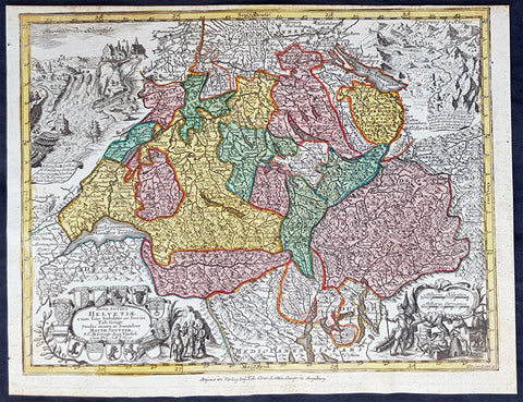
1744 Georg Mattaus Seutter Antique Map of Switzerland, Helvetia
- Title : Nova Totius Helvetiae........a Matth. Seutteri...T C Lotter, Geogr.
- Ref #: 93397
- Size: 11in x 8 1/2in (280mm x 215mm)
- Date : 1744
- Condition: (A+) Fine Condition
Description:
This beautifully hand coloured original copper-plate engraved antique map of Switzerland was engraved by Tobias Lotter and was published in the 1744 edition of GM Seutters Atlas Minor Prae cipua Orbis Terrarum Imperia Regna et Provincias...., Augsburg, Germany.
General Definitions:
Paper thickness and quality: - Heavy and stable
Paper color : - off white
Age of map color: - Original
Colors used: - Yellow, green, blue, pink
General color appearance: - Authentic
Paper size: - 11in x 8 1/2in (280mm x 215mm)
Plate size: - 10 1/2in x 8in (265mm x 205mm)
Margins: - Min 1/4in (5mm)
Imperfections:
Margins: - None
Plate area: - None
Verso: - None
Background:
Atlas Minor was a series of beautiful maps of all parts of the world. Georg Matthäus Seutter was one of the most and important of the German cartographers of the 18th century, being appointed as the Geographer to the Imperial Court. His son, Albrecht Carl, joined Matthäus and eventually inherited the business. The maps from Atlas Minor were drawn by the two Seutters and engraved by Tobias Conrad Lotte. These maps are highly detailed and engraved with a bold hand with equally strong original hand color in the body of the map as was the 18th century German style. The cartouches were left uncolored in order to emphasize the elaborately detailed illustrations for which German maps are especially prized. These are some of the most decorative and interesting maps of the eighteenth century.
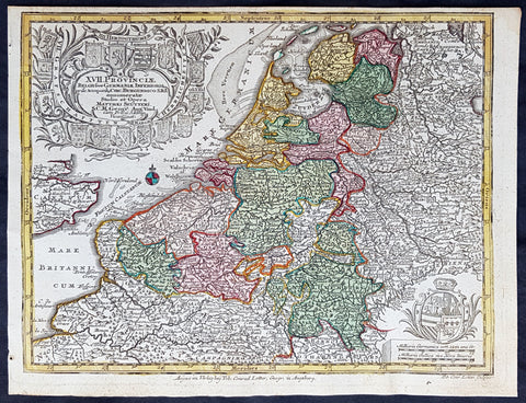
1744 Georg Mattaus Seutter Antique Map of The Netherlands, XVII Provinces
- Title : XVII Provinciae.......a Matth. Seutteri...T C Lotter, Geogr.
- Ref #: 93395
- Size: 11in x 8 1/2in (280mm x 215mm)
- Date : 1744
- Condition: (A+) Fine Condition
Description:
This beautifully hand coloured original copper-plate engraved antique map of The Netherlands was engraved by Tobias Lotter and was published in the 1744 edition of GM Seutters Atlas Minor Prae cipua Orbis Terrarum Imperia Regna et Provincias...., Augsburg, Germany.
General Definitions:
Paper thickness and quality: - Heavy and stable
Paper color : - off white
Age of map color: - Original
Colors used: - Yellow, green, blue, pink
General color appearance: - Authentic
Paper size: - 11in x 8 1/2in (280mm x 215mm)
Plate size: - 10 1/2in x 8in (265mm x 205mm)
Margins: - Min 1/4in (5mm)
Imperfections:
Margins: - Light age toning
Plate area: - Light age toning
Verso: - None
Background:
Atlas Minor was a series of beautiful maps of all parts of the world. Georg Matthäus Seutter was one of the most and important of the German cartographers of the 18th century, being appointed as the Geographer to the Imperial Court. His son, Albrecht Carl, joined Matthäus and eventually inherited the business. The maps from Atlas Minor were drawn by the two Seutters and engraved by Tobias Conrad Lotte. These maps are highly detailed and engraved with a bold hand with equally strong original hand color in the body of the map as was the 18th century German style. The cartouches were left uncolored in order to emphasize the elaborately detailed illustrations for which German maps are especially prized. These are some of the most decorative and interesting maps of the eighteenth century.
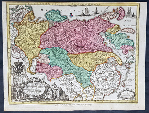
1744 Georg Mattaus Seutter Antique Map of The Russian Empire, China, Japan
- Title : Imperium Russiae Magnae........a Matth. Seutteri...T C Lotter, Geogr.
- Ref #: 93401
- Size: 11in x 8 1/2in (280mm x 215mm)
- Date : 1744
- Condition: (A+) Fine Condition
Description:
This beautifully hand coloured original copper-plate engraved antique map of The Russian Empire was engraved by Tobias Lotter and was published in the 1744 edition of GM Seutters Atlas Minor Prae cipua Orbis Terrarum Imperia Regna et Provincias...., Augsburg, Germany.
General Definitions:
Paper thickness and quality: - Heavy and stable
Paper color : - off white
Age of map color: - Original
Colors used: - Yellow, green, blue, pink
General color appearance: - Authentic
Paper size: - 11in x 8 1/2in (280mm x 215mm)
Plate size: - 10 1/2in x 8in (265mm x 205mm)
Margins: - Min 1/4in (5mm)
Imperfections:
Margins: - None
Plate area: - None
Verso: - None
Background:
Atlas Minor was a series of beautiful maps of all parts of the world. Georg Matthäus Seutter was one of the most and important of the German cartographers of the 18th century, being appointed as the Geographer to the Imperial Court. His son, Albrecht Carl, joined Matthäus and eventually inherited the business. The maps from Atlas Minor were drawn by the two Seutters and engraved by Tobias Conrad Lotte. These maps are highly detailed and engraved with a bold hand with equally strong original hand color in the body of the map as was the 18th century German style. The cartouches were left uncolored in order to emphasize the elaborately detailed illustrations for which German maps are especially prized. These are some of the most decorative and interesting maps of the eighteenth century.
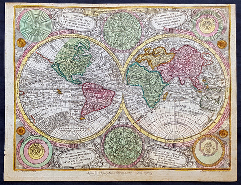
1744 Georg Mattaus Seutter Antique Twin Hemisphere World Map, California as Island
- Title : Diversi Globe Terr-Aqveia a Matth. Seutteri...T C Lotter, Geogr.
- Ref #: 93387
- Size: 11in x 8 1/2in (280mm x 215mm)
- Date : 1744
- Condition: (A+) Fine Condition
Description:
These beautifully hand coloured original copper-plate engraved antique map was engraved by Tobias Lotter and published in the 1744 edition of GM Seutters Atlas Minor Prae cipua Orbis Terrarum Imperia Regna et Provincias...., Augsburg, Germany.
General Definitions:
Paper thickness and quality: - Heavy and stable
Paper color : - off white
Age of map color: - Early
Colors used: - Yellow, green, blue, pink
General color appearance: - Authentic
Paper size: - 11in x 8 1/2in (280mm x 215mm)
Plate size: - 10 1/2in x 8in (265mm x 205mm)
Margins: - Min 1/4in (5mm)
Imperfections:
Margins: - None
Plate area: - None
Verso: - None
Background:
Atlas Minor was a series of beautiful maps of all parts of the world. Georg Matthäus Seutter was one of the most and important of the German cartographers of the 18th century, being appointed as the Geographer to the Imperial Court. His son, Albrecht Carl, joined Matthäus and eventually inherited the business. The maps from Atlas Minor were drawn by the two Seutters and engraved by Tobias Conrad Lotte. These maps are highly detailed and engraved with a bold hand with equally strong original hand color in the body of the map as was the 18th century German style. The cartouches were left uncolored in order to emphasize the elaborately detailed illustrations for which German maps are especially prized. These are some of the most decorative and interesting maps of the eighteenth century.
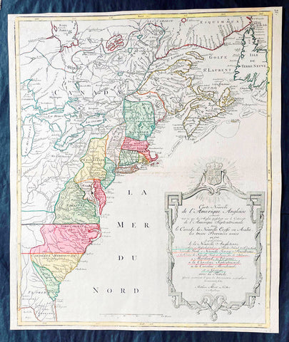
1776 Tobias Lotter Large Antique Post Revolutionary North America Map 13 Colonies
- Title : Carte Nouvelle de l Amerique Angloise Contenant Tout ce que les Anglois Possedent sur le Continent de l'Amerique Septentrionale Savior le Canada, la Nouvelle Ecosse ou Acadie, les Treize Provinces Unies ... avec la Floride
- Ref #: 27009
-
Condition: (A+) Fine Condition
- Size: 25in x 21 1/2in (635mm x 545mm)
- Date : 1776
Description:
This is possibly one of the last significant maps, of the original 13 American colonies, published prior to the American Revolution for Independence from Britain, beginning in 1763 and ending with the signing of the Declaration of Independence in 1776.
Published in Augsberg, Germany in 1776 by Conrad Tobias Lotter, this large original antique map reflects both the French & German interests in North America just prior to the outbreak of hostilities.
The map covers the area from the James Bay to the Gulf of Mexico and west to Lake Michigan. It shows provinces, towns and cities, some forts and trails, as well as Indian villages and tribal territory. (Ref: Tooley, M&B)
General Definitions:
Paper thickness and quality: - Heavy and stable
Paper color : - off white
Age of map color: - Original & later
Colors used: - Yellow, green, blue, pink
General color appearance: - Authentic
Paper size: - 25in x 21 1/2in (635mm x 545mm)
Plate size: - 24in x 19 1/2in (610mm x 495mm)
Margins: - Min 1/2in (12mm)
Imperfections:
Margins: - None
Plate area: - None
Verso: - None
Background:
Each of the thirteen Colonies is identified by name both on the map, and in the title. The title is placed within an attractive decorative border surmounted by the British Royal arms. The French title and nomenclature indicates that Lotter, a leading German mapmaker, intended this for the French market, as does the fact that he limits the claims of the British to the regions east of the Appalachian Mountains. The delineation of the thirteen Provinces unies is generally well done (although Maryland and Georgia are both strangely shaped): a number of locations are named in the Ohio Valley, including Logs Town, Twictwees, Ft. Du Quesne, Allegheny, Vinango, Buffaloons, Sandoski and Mingos. Some interesting details are also shown in the region of the Great Lakes.
Please note all items auctioned are genuine, we do not sell reproductions. A Certificate of Authenticity (COA) can be issued on request.
1776 Tobias Lotter Large Antique Post Revolutionary North America Map 13 Colonies
- Title : Carte Nouvelle de l Amerique Angloise Contenant Tout ce que les Anglois Possedent sur le Continent de l'Amerique Septentrionale Savior le Canada, la Nouvelle Ecosse ou Acadie, les Treize Provinces Unies ... avec la Floride
- Ref #: 17000
-
Condition: (A+) Fine Condition
- Size: 25in x 21 1/2in (635mm x 545mm)
- Date : 1776
- Price: $1,750.00US
Description:
This is possibly one of the last significant maps, of the original 13 American colonies, published prior to the American Revolution for Independence from Britain, beginning in 1763 and ending with the signing of the Declaration of Independence in 1776.
Published in Augsberg, Germany in 1776 by Conrad Tobias Lotter, this large original antique map reflects both the French & German interests in North America just prior to the outbreak of hostilities.
The map covers the area from the James Bay to the Gulf of Mexico and west to Lake Michigan. It shows provinces, towns and cities, some forts and trails, as well as Indian villages and tribal territory. (Ref: Tooley, M&B)
General Definitions:
Paper thickness and quality: - Heavy and stable
Paper color : - off white
Age of map color: - Original & later
Colors used: - Yellow, green, blue, pink
General color appearance: - Authentic
Paper size: - 25in x 21 1/2in (635mm x 545mm)
Plate size: - 24in x 19 1/2in (610mm x 495mm)
Margins: - Min 1/2in (12mm)
Imperfections:
Margins: - None
Plate area: - None
Verso: - None
Background:
Each of the thirteen Colonies is identified by name both on the map, and in the title. The title is placed within an attractive decorative border surmounted by the British Royal arms. The French title and nomenclature indicates that Lotter, a leading German mapmaker, intended this for the French market, as does the fact that he limits the claims of the British to the regions east of the Appalachian Mountains. The delineation of the thirteen Provinces unies is generally well done (although Maryland and Georgia are both strangely shaped): a number of locations are named in the Ohio Valley, including Logs Town, Twictwees, Ft. Du Quesne, Allegheny, Vinango, Buffaloons, Sandoski and Mingos. Some interesting details are also shown in the region of the Great Lakes.
Please note all items auctioned are genuine, we do not sell reproductions. A Certificate of Authenticity (COA) can be issued on request.