Europe (12)
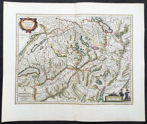
1647 Willem Blaeu Large Antique Map of Switzerland - Helvetia
- Title : Helvetia cum sinitimis regionibus confoederatis
- Ref #: 61109
- Size: 24in x 20in (610mm x 510mm)
- Date : 1647
- Condition: (A+) Fine Condition
Description:
This fine, beautifully hand coloured original antique map* of Switzerland by Willem Blaeu was published in the 1647 Dutch edition of Atlas Novus.
This map, engraved by Blaeu but attributed to Gerard Mercator, is in fine condition with fine original margins, clean stable paper and original colour. A beautiful example of this map by Blaeu after Mercator.
General Description:
Paper thickness and quality: - Heavy and stable
Paper color: - off white
Age of map color: - Original
Colors used: - Yellow, pink, red, blue, green
General color appearance: - Authentic
Paper size: - 24in x 20in (610mm x 510mm)
Plate size: - 20in x 15 1/4in (510mm x 390mm)
Margins: - Min 2in (50mm)
Imperfections:
Margins: - None
Plate area: - None
Verso: - None
Background: The first printed map of Switzerland was published in Martin Waldseemuller's edition of Ptolemy in Strasbourg in 1513, but the manuscript map by Konrad Turst (1497) drawn to scale was a splendid first achievement for its time. Also the research of Vadianus at St Gallen University produced notable work, and along with the Germanic influence in Basle, which became part of the Swiss Confederation in 1501, and the highly developed wood engraving skills there, were important factors in European map publishing.
The almost endless editions of Sebastian Munster's Cosmographia were published in Basle from 1540 for nearly a century and Zurich can claim to have published the first national atlas produced anywhere -that of Johann Stumpf in 1548-52.
By comparison with her larger neighbours, Germany and Italy, Switzerland is considered not to have made a major contribution to Cartographic history. But over the years this has been contradicted, especially starting in the sixteenth century. In the second half of the sixteenth century many maps of the Swiss Cantons, in manuscript or woodcuts appeared, but the mountainous nature of the country produced its own mapping problems and imposed a need for large-scale surveys as well as practical and effective methods of showing land surfaces in relief. Early in the seventeenth century Hans Gyger perfected new ways of doing this but although he published a wide range of very large-scale maps of the cantons and of Switzerland as a whole his techniques did not receive the credit they deserved. On the other hand, his countrymen followed his example of compiling large-scale maps for which they have always been noted for up until the present day. (Ref: Koeman; M&B)
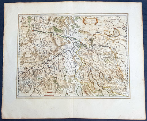
1659 Joan Blaeu Large Antique Map of The Swiss Cantons of Zurich, Aargau & Basel
- Title : Zurichgow et Basiliensis Provincia
- Size: 24 1/2in x 20in (625mm x 510mm)
- Condition: (A+) Fine Condition
- Date : 1659
- Ref #: 30280
Description:
This beautiful original copper plate engraved antique map of the Swiss Canton of Zurich with parts of Aargau & Basel Cantons was published by Joan Blaeu in the rare 1659 Spanish edition of Atlas major
Atlas Major or Great Atlas During the early hours of the 23rd of February 1672, a fire broke out and engulfed a building on Gravenstraat, in the centre of Amsterdam. Such an event at the time was unremarkable, until it was recognised that the fire had brought to an end of one of the greatest publishing houses of all time. Dr Joan Blaeus family were responsible for printing and publishing some of the most important maps, atlases, religious and philosophical books, that are recognised even today, as remarkable. The fire was described in suitably vivid terms in the annual review publication, De Hollandtse Mercurius for 1672-1673
.............the disaster occurred at 3.30 on the morning of the 23rd of February because of the dryness of the timbers, or perhaps the carelessness of the apprentices; the magnificent establishment caught fire, and with it printing type, presses, plates and paper, were all burnt and sparks were sent flying as far as the Tol-heck (Toll Gate). One report put the financial cost of the damage at fl. 27, 000 for the buildings and some fl 355,000 for the plate-stock in the printing works and shop premises, to give total estimated losses of fl. 382, 000 (or about $25milUS in modern terms) together with some four or five thousand reams of paper, five or six thousand sheets, 88 thousand kg. printing type and so on...................
The fire precipitated the end of a publishing house established over 40 years before, and very probably contributed to the death of its proprietor, Alderman Dr Joan Blaeu, a year later, effectively ending the reign of one of the greatest producers of printed maps and atlases in publishing history. Only 10 years previously, in 1662, the house had reached its zenith with the publication of its greatest achievement, the Atlas Major or Great Atlas, containing 11 volumes with geographical detail reflecting many of the achievements of the Golden Age of the United Netherlands.
General Definitions:
Paper thickness and quality: - Heavy and stable
Paper color : - off white
Age of map color: - Original
Colors used: - Blue, pink, red, green, yellow
General color appearance: - Authentic
Paper size: - 24 1/2in x 20in (625mm x 510mm)
Plate size: - 19 1/2in x 15in (500mm x 385mm)
Margins: - Min 2in (50mm)
Imperfections:
Margins: - Light age toning to margin edges
Plate area: - None
Verso: - None
Background:
Switzerland
By comparison with her larger neighbours, Germany and Italy, it may not be considered that Switzerland has made a major contribution to the history of cartography, but in the sixteenth century especially Swiss influence was by no means negligible. Certainly the first printed map of Switzerland was published in Martin Waldseemuller\'s edition of Ptolemy at Strasburg in 1513, but the manuscript map by Konrad Turst (1497) drawn to scale was a splendid achievement for its time and the researches of Vadianus at St Gallen University produced notable work; the Germanic influence in Basle, which became part of the Swiss Confederation in 1501, and the highly developed wood engraving skills there were important factors in European map publishing. The almost endless editions of Munster were published there from 1540 onwards for nearly a century and Zurich can claim to have published the first national atlas produced anywhere -that of Johann Stumpf in 1548-52.
In the second half of the sixteenth century many maps of the cantons in manuscript or woodcut appeared but the mountainous nature of the country produced its own mapping problems and imposed a need for large-scale suAbraham Orteliusbrveys as well as practical and effective methods of showing land surfaces in relief. Early in the seventeenth century Hans Gyger perfected new ways of doing this but although he published a wide range of very large-scale maps of the cantons and of Switzerland as a whole his techniques did not receive the acceptance they deserved. On the other hand his countrymen followed his precedent of compiling large-scale maps for which they have always been noted until the present day. (Ref:Koeman; Tooley)
Please note all items auctioned are genuine, we do not sell reproductions. A Certificate of Authenticity (COA) can be issued on request.
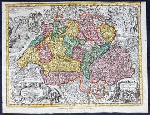
1744 Georg Mattaus Seutter Antique Map of Switzerland, Helvetia
- Title : Nova Totius Helvetiae........a Matth. Seutteri...T C Lotter, Geogr.
- Ref #: 93397
- Size: 11in x 8 1/2in (280mm x 215mm)
- Date : 1744
- Condition: (A+) Fine Condition
Description:
This beautifully hand coloured original copper-plate engraved antique map of Switzerland was engraved by Tobias Lotter and was published in the 1744 edition of GM Seutters Atlas Minor Prae cipua Orbis Terrarum Imperia Regna et Provincias...., Augsburg, Germany.
General Definitions:
Paper thickness and quality: - Heavy and stable
Paper color : - off white
Age of map color: - Original
Colors used: - Yellow, green, blue, pink
General color appearance: - Authentic
Paper size: - 11in x 8 1/2in (280mm x 215mm)
Plate size: - 10 1/2in x 8in (265mm x 205mm)
Margins: - Min 1/4in (5mm)
Imperfections:
Margins: - None
Plate area: - None
Verso: - None
Background:
Atlas Minor was a series of beautiful maps of all parts of the world. Georg Matthäus Seutter was one of the most and important of the German cartographers of the 18th century, being appointed as the Geographer to the Imperial Court. His son, Albrecht Carl, joined Matthäus and eventually inherited the business. The maps from Atlas Minor were drawn by the two Seutters and engraved by Tobias Conrad Lotte. These maps are highly detailed and engraved with a bold hand with equally strong original hand color in the body of the map as was the 18th century German style. The cartouches were left uncolored in order to emphasize the elaborately detailed illustrations for which German maps are especially prized. These are some of the most decorative and interesting maps of the eighteenth century.
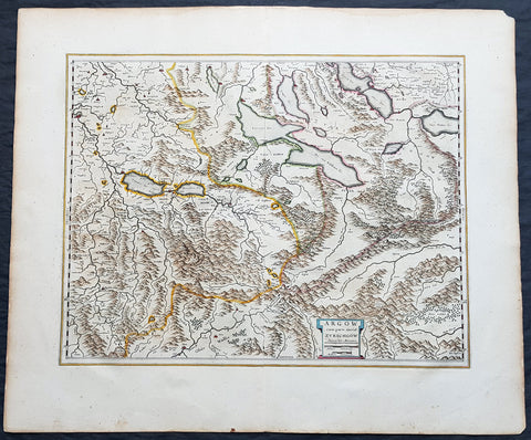
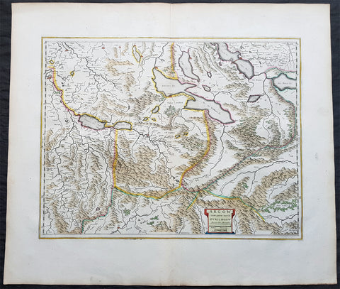
1659 Joan Blaeu Antique Map of The Cantons of Aargau & Zurich, Switzerland
- Title : Argow cum Parte Merid. Zurchgow
- Ref #: 30282
- Size: 24in x 21in (610mm x 535mm)
- Date : 1659
- Condition: (A+) Fine Condition
Description:
This beautifully hand coloured original antique map of the Cantons of Zurich & Aargau in North West Switzerland was published in the 1659 Spanish edition of Joan Blaeus Atlas Novusafter Gerard Mercator.
General Definitions:
Paper thickness and quality: - Heavy and stable
Paper color : - off white
Age of map color: - Original
Colors used: - Blue, pink, red, green, yellow
General color appearance: - Authentic
Paper size: - 24in x 21in (610mm x 535mm)
Plate size: - 21in x 16 1/2in (535mm x 420mm)
Margins: - Min 1in (25mm)
Imperfections:
Margins: - None
Plate area: - None
Verso: - None
Background:
The 26 cantons of Switzerland are the member states of the Swiss Confederation. The nucleus of the Swiss Confederacy in the form of the first three confederate allies used to be referred to as the Waldstätte. Two further major steps in the development of the Swiss cantonal system are referred to by the terms Acht Orte (Eight Cantons; between 1353 and 1481) and Dreizehn Orte (Thirteen Cantons,during 1513–1798); they were important intermediate periods of the Ancient Swiss Confederacy.
Each canton, formerly also Ort (from before 1450), or Stand (estate, from c. 1550), was a fully sovereign state with its own border controls, army, and currency from at least the Treaty of Westphalia (1648) until the establishment of the Swiss federal state in 1848; with a brief period of centralized government during the Helvetic Republic (1798–1803). With the Napoleonic period of the Helvetic Republic the term Kanton was also fully established in German-speaking region.
From 1833, there were 25 cantons, increasing to 26 after the secession of the canton of Jura from Bern in 1979.
The canton of Aargau is one of the more northerly cantons of Switzerland. It is situated by the lower course of the Aare, which is why the canton is called Aar-gau (meaning Aare province). It is one of the most densely populated regions of Switzerland.
The canton of Zürich is a Swiss canton in the northeastern part of the country. It is the most populated canton in the country. Its capital is the city of Zürich. The official language is German. The local Swiss German dialect, called Züritüütsch, is commonly spoken. In English the name of the canton and its capital is often written without an umlaut.
1650 Joan Blaeu Antique Map of The Cantons of Aargau & Zurich, Switzerland
- Title : Argow cum Parte Merid. Zurchgow
- Ref #: 40331
- Size: 24in x 21in (610mm x 535mm)
- Date : 1650
- Condition: (A+) Fine Condition
Description:
This beautifully hand coloured original antique map of the Cantons of Zurich & Aargau in North West Switzerland was published in the 1650 Dutch edition of Joan Blaeus Atlas Novusafter Gerard Mercator.
General Definitions:
Paper thickness and quality: - Heavy and stable
Paper color : - off white
Age of map color: - Original
Colors used: - Blue, pink, red, green, yellow
General color appearance: - Authentic
Paper size: - 24in x 21in (610mm x 535mm)
Plate size: - 21in x 16 1/2in (535mm x 420mm)
Margins: - Min 1in (25mm)
Imperfections:
Margins: - None
Plate area: - None
Verso: - None
Background:
The 26 cantons of Switzerland are the member states of the Swiss Confederation. The nucleus of the Swiss Confederacy in the form of the first three confederate allies used to be referred to as the Waldstätte. Two further major steps in the development of the Swiss cantonal system are referred to by the terms Acht Orte (Eight Cantons; between 1353 and 1481) and Dreizehn Orte (Thirteen Cantons,during 1513–1798); they were important intermediate periods of the Ancient Swiss Confederacy.
Each canton, formerly also Ort (from before 1450), or Stand (estate, from c. 1550), was a fully sovereign state with its own border controls, army, and currency from at least the Treaty of Westphalia (1648) until the establishment of the Swiss federal state in 1848; with a brief period of centralized government during the Helvetic Republic (1798–1803). With the Napoleonic period of the Helvetic Republic the term Kanton was also fully established in German-speaking region.
From 1833, there were 25 cantons, increasing to 26 after the secession of the canton of Jura from Bern in 1979.
The canton of Aargau is one of the more northerly cantons of Switzerland. It is situated by the lower course of the Aare, which is why the canton is called Aar-gau (meaning Aare province). It is one of the most densely populated regions of Switzerland.
The canton of Zürich is a Swiss canton in the northeastern part of the country. It is the most populated canton in the country. Its capital is the city of Zürich. The official language is German. The local Swiss German dialect, called Züritüütsch, is commonly spoken. In English the name of the canton and its capital is often written without an umlaut.
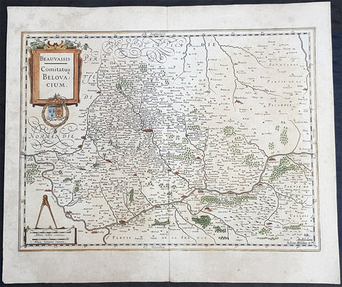
1628 Henricus Hondius Antique Map Beauvais Region of Northern France, Oise River
- Title : Beauvaisis Comitatus Belovacium
- Size: 22in x 18 1/2in (560mm x 470mm)
- Condition: (A) Very Good Condition
- Date : 1628
- Ref #: 50230
Description:
This original hand coloured copper plate engraved antique map of the Beauvais region of Northern France - centering on the city of Beauvais & the Oise River running through the cities of Noyon, Compiègne, Creil, by Henricus Hondius was published by Henricus Hondius & Jan Jansson in the 1628 French edition of Gerard Mercators Atlas.
General Definitions:
Paper thickness and quality: - Heavy and stable
Paper color : - off white
Age of map color: - Original
Colors used: - Blue, pink, red, green, yellow
General color appearance: - Authentic
Paper size: - 22in x 18 1/2in (560mm x 470mm)
Plate size: - 20in x 15in (510mm x 380mm)
Margins: - Min 1in (25mm)
Imperfections:
Margins: - Age toning
Plate area: - Age toning
Verso: - Age toning
Background:
Beauvais is a city and commune in northern France. It serves as the capital of the Oise département, in the Hauts-de-France region. Beauvais is located approximately 75 kilometres from Paris.
Beauvais was known to the Romans by the Gallo-Roman name of Caesaromagus (magos is Common Celtic for field). The post-Renaissance Latin rendering is Bellovacum from the Belgic tribe the Bellovaci, whose capital it was. In the ninth century it became a countship, which about 1013 passed to the bishops of Beauvais, who became peers of France from the twelfth century. At the coronations of kings the Bishop of Beauvais wore the royal mantle and went, with the Bishop of Langres, to raise the king from his throne to present him to the people.
De Bello Gallico II 13 reports that as Julius Caesar was approaching a fortified town called Bratuspantium in the land of the Bellovaci, its inhabitants surrendered to him when he was about 5 Roman miles away. Its name is Gaulish for place where judgements are made, from *bratu-spantion. Some say that Bratuspantium is Beauvais. Others theorize that it is Vendeuil-Caply or Bailleul sur Thérain.
From 1004 to 1037, the Count of Beauvais was Odo II, Count of Blois.
In a charter dated 1056/1060, Eudo of Brittany granted land in pago Belvacensi (Beauvais, Picardy) to the Abbey of Angers Saint-Aubin
In 1346 the town had to defend itself against the English, who again besieged it in 1433. The siege which it endured in 1472 at the hands of the Duke of Burgundy, was rendered famous by the heroism of the towns women, under the leadership of Jeanne Hachette, whose memory is still celebrated by a procession on 27 June (the feast of Sainte Angadrême), during which women take precedence over men.
An interesting hoard of coins from the High Middle Ages became known as the Beauvais Hoard, because some of the British and European coins found with the lot were from the French abbey located in Beauvais. The hoard, which contained a variety of rare and extremely rare Anglo-Norman pennies, English and foreign coins, was reputed to have been found in or near Paris.
Please note all items auctioned are genuine, we do not sell reproductions. A Certificate of Authenticity (COA) can be issued on request.
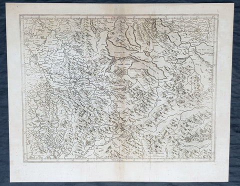
1628 Gerard Mercator & Henricus Hondius Antique Map Canton of Aargau Switzerland
- Title : Argow...Per Geradum Mercatorem Cum Privilego...
- Size: 21in x 17in (530mm x 430mm)
- Condition: (A) Very Good Condition
- Date : 1628
- Ref #: 26090
Description:
This original copper plate engraved antique map of the Canton of Aargau, Switzerland by Gerard Mercator was published by Henricus Hondius in the early 1628 French edition of Gerard Mercators Atlas.
These maps, published in the early editions of Mercators atlas, are the original maps drawn and engraved by Gerald Mercator in the mid to late 16th century, published by his son Rumold as an atlas, after his death, in 1595. After two editions the plates were purchased by Jodocus Hondius in 1604, and continued to be published until the end of the 1630s by Henricus Hondius, when some of the plates were re-engraved and updated with the help of Jan Jansson.
General Definitions:
Paper thickness and quality: - Heavy and stable
Paper color : - off white
Age of map color: -
Colors used: -
General color appearance: -
Paper size: - 21in x 17in (530mm x 430mm)
Plate size: - 18 1/2in x 14in (475mm x 350mm)
Margins: - Min 1/2in (12mm)
Imperfections:
Margins: - Light age toning
Plate area: - Light toning along centerfold
Verso: - Light age toning
Background:
The area of Aargau and the surrounding areas were controlled by the Helvetians, a member of the Celts, as far back as 200 BC, eventually being occupied by the Romans and then by the 6th century, the Franks. The Romans built a major settlement called Vindonissa, near the present location of Brugg.
The reconstructed Old High German name of Aargau is Argowe, first unambiguously attested (in the spelling Argue) in 795. The term described a territory only loosely equivalent to that of the modern canton, including the region between Aare and Reuss, including Pilatus and Napf, i.e. including parts of the modern cantons of Berne (Bernese Aargau, Emmental, parts of the Bernese Oberland), Solothurn, Basel-Landschaft, Lucerne, Obwalden and Nidwalden, but not the parts of the modern canton east of the Reuss (Baden District), which were part of Zürichgau.
Within the Frankish Empire (8th to 10th centuries), the area was a disputed border region between the duchies of Alamannia and Burgundy. A line of the von Wetterau (Conradines) intermittently held the countship of Aargau from 750 until about 1030, when they lost it (having in the meantime taken the name von Tegerfelden). This division became the ill-defined (and sparsely settled) outer border of the early Holy Roman Empire at its formation in the second half of the 10th century. Most of the region came under the control of the ducal house of Zähringen and the comital houses of Habsburg and Kyburg by about 1200.
In the second half of the 13th century, the territory became divided between the territories claimed by the imperial cities of Berne, Lucerne and Solothurn and the Swiss canton of Unterwalden. The remaining portion, largely corresponding to the modern canton of Aargau, remained under the control of the Habsburgs until the conquest of Aargau by the Old Swiss Confederacy in 1415. Habsburg Castle itself, the original seat of the House of Habsburg, was taken by Berne in April 1415. The Habsburgs had founded a number of monasteries (with some structures enduring, e.g., in Wettingen and Muri), the closing of which by the government in 1841 was a contributing factor to the outbreak of the Swiss civil war – the Sonderbund War – in 1847.
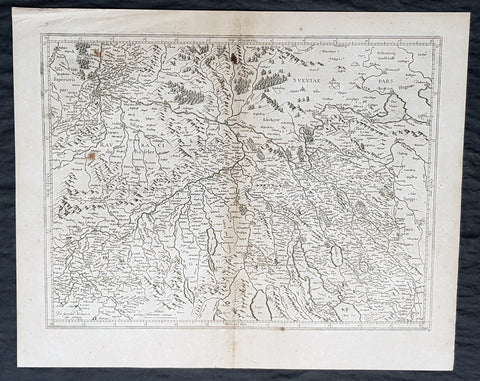
1628 Gerard Mercator & Henricus Hondius Antique Map Canton of Zurich Switzerland
- Title : Zurichgow...Per Geradum Mercatorem Cum Privilego...
- Size: 21in x 17in (530mm x 430mm)
- Condition: (A) Very Good Condition
- Date : 1628
- Ref #: 26093
Description:
This original copper plate engraved antique map of the Canton of Zurich, Switzerland by Gerard Mercator was published by Henricus Hondius in the early 1628 French edition of Gerard Mercators Atlas.
These maps, published in the early editions of Mercators atlas, are the original maps drawn and engraved by Gerald Mercator in the mid to late 16th century, published by his son Rumold as an atlas, after his death, in 1595. After two editions the plates were purchased by Jodocus Hondius in 1604, and continued to be published until the end of the 1630s by Henricus Hondius, when some of the plates were re-engraved and updated with the help of Jan Jansson.
General Definitions:
Paper thickness and quality: - Heavy and stable
Paper color : - off white
Age of map color: -
Colors used: -
General color appearance: -
Paper size: - 21in x 17in (530mm x 430mm)
Plate size: - 18 1/2in x 14in (475mm x 350mm)
Margins: - Min 1/2in (12mm)
Imperfections:
Margins: - Light age toning
Plate area: - Light toning along centerfold
Verso: - Light age toning
Background:
The territory of the canton of Zürich corresponds to the lands acquired by the city of Zürich after it became reichsfrei in 1218. Zürich pursued a policy of aggressive territorial expansion especially during the century following the revolution of the guilds in 1336. Zürich joined the Swiss Confederacy in 1351.
Zürich claimed and lost the Toggenburg in the Old Zürich War of the 1440s. The northern parts up to the river Rhine came to the canton after the city of Zürich purchased Winterthur from the Habsburgs in 1468. In 1651, Zürich purchased Rafzerfeld from the counts of Sulz. At this point, almost all of the territory of the modern canton (as well as some territories beyond its modern borders) was owned by Zürich; exceptions include Wülflingen (acquired 1760), Buch (acquired 1761), Dietikon, which was a condominium, and Rheinau (owned by Rheinau Abbey).
In the 18th century, the inner bailiwicks (Innere Vogteien) were under direct administration of city officials, while the outer bailiwicks (Äussere Vogteien) were ruled by the reeves of Kyburg, Grüningen, Greifensee, Eglisau, Regensberg, Andelfingen, Wädenswil, and Knonau. The city of Winterthur was nominally subject to Zürich but retained far-reaching autonomy.
Zürichgau, the name of the medieval pagus, was in use for the territories of the city of Zürich during the 15th and 16th century; the term canton (Kanton) gradually entered use in the 16th century, but Zürichgau remained widely used well into the 19th century (becoming obsolescent after the formation of the modern canton in 1831).
Under the short-lived Helvetic Republic (1798–1803), the canton of Zürich became a purely administrative division. In 1803, some former possessions of Zürich to the west gained independence as part of the Canton of Aargau. In 1804 the Kantonspolizei Zürich was established as Landjäger-Corps des Kantons Zürich.
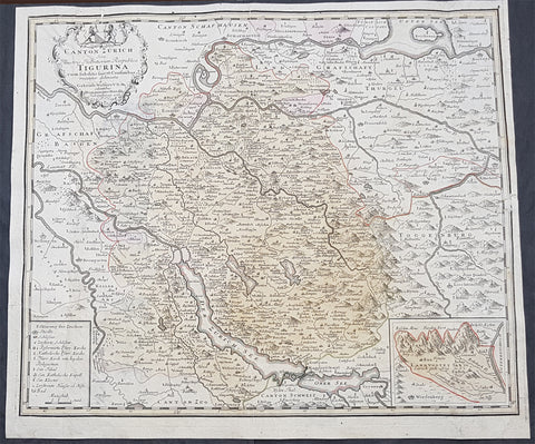
1765 Homann Large Antique Map of The Zurich Canton, Switzerland - Tigurini
- Title : Canton Zurich sive Illustratis Helvetiorum Respublica Tigurina...1765
- Ref #: 50175
- Size: 23 1/2in x 20in (595mm x 510mm)
- Date : 1765
- Condition: (B) Good Condition
Description:
This large original hand coloured copper plate engraved antique map of the Zurich Canton of Switzerland, the hoome of the Tigurini Tribe of Helvetii, by the Homann firm was engraved in 1765 - dated.
General Definitions:
Paper thickness and quality: - Heavy and stable
Paper color : - off white
Age of map color: - Original
Colors used: - Yellow, orange
General color appearance: - Authentic
Paper size: - 23 1/2in x 20in (595mm x 510mm)
Plate size: - 22in x 19in (560mm x 485mm)
Margins: - Min 1/2in (12mm)
Imperfections:
Margins: - Small repair to top and left margins
Plate area: - None
Verso: - Soiling and re-enforced to the left of the verso
Background:
The Tigurini were a clan or tribe forming one out of four pagi (provinces) of the Helvetii.[1][2] The Tigurini were the most important group of the Helvetii, mentioned by both Caesar and Poseidonius, settling in the area of what is now the Swiss canton of Vaud, corresponding to the bearers of the late La Tène culture in western Switzerland. Their name has a meaning of lords, rulers (cognate with Irish tigern lord). The other Helvetian tribes included the Verbigeni and the Tougeni (sometimes identified with the Teutones), besides one tribe that has remained unnamed.
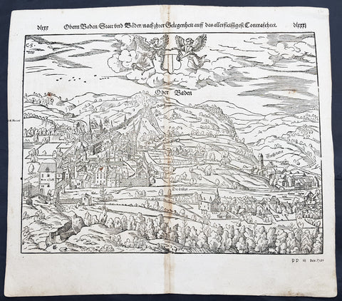
1598 Munster Antique Map Birds Eye View of Baden bei Zürich, Aargau, Switzerland
- Title : Die Statt Baden
- Date : 1598
- Condition: (A) Very Good Condition
- Ref # : 30357
- Size : 15in x 13in (380mm x 340mm)
Description:
This fine original wood block engraved antique map a birds eye view of the Swiss city of Baden bei Zürich on the Limmat River in the Canton of Aargau was published in the German Section of Sebastian Munsters 1598 edition of Cosmographia, Das ist: Beschreibung der gantzen Welt, Darinnen Aller Monarchien Keyserthumben, Königreichen, Fürstenthumben, Graff- und Herrschafften, Länderen, Stätten und Gemeinden.Ursprung (Cosmographia, that is: description of the whole world, in it all monarchies Keyser thumben, kingdoms, prince thumben, graff and herrschafften, countries, places and municipalities.)
Baden sometimes unofficially, to distinguish it from other Badens, called Baden bei Zürich (Baden near Zürich) or Baden im Aargau (Baden in Aargau) is a municipality in Switzerland. It is the seat of the district of Baden in the canton of Aargau. Located 25 km northwest of Zürich in the Limmat Valley (Limmattal) mainly on the western side of the Limmat, its mineral hot springs have been famed since at least the Roman era.
Baden is first attested in Roman sources as Aquae Helveticae (Waters of the Helvetii). Hippocrates had counseled against the use of water from mineral springs, but by the time of Vitruvius, Pliny, and Galen they were being selectively employed for certain ailments. In addition to their medical use, the Romans also revered natural springs for recreational and religious use. Tacitus mentions the town obliquely, describing it as a place built up into a semblance of a town... much used for its healthful waters. This Roman vicus was to the north of the Baden gorge on the Haselfeld, founded to support the legionary camp at Vindonissa. There was a pool complex on the left bank of the Limmat fed by a system of springs with 47 °C water. The main axis of the vicus was the Vindonissa road, which ran parallel to the slope. It was flanked by porticos, beyond which lay commercial and residential buildings. The center of the settlement had some wealthy villa-like structures. The resort, residential, and commercial districts all grew to a respectable size over the first half of the 1st century. In ad 69, however, the 21st Legion burned the town amid the conflicts of the Year of the Four Emperors. Its wooden buildings destroyed, the town was rebuilt in stone. The town shrank some after the closing of the Vinonissa camp in ad 101 but survived on trade. Reginus\'s pottery workshop and Gemellianus\'s bronze works flourished during the second half of the 2nd century Around the middle of the 3rd century, however, the settlement was threatened by multiple Alemanni invasions and the Huns. The pools were fortified and a large number of coins stamped with references to the hot springs show it continued to be settled and frequented into late antiquity, but expansion of the settlement of Haselfeld came to an end.
The baths were frequented again by the time of Charlemagne. A medieval necropolis in Kappelerhof has been dated as far back as the 7th century and a local lord fortifying the Stein by the 10th. The modern name Baden is first attested in 1040. Around that time, its land was held by the Lenzburgs, some of whom styled themselves as the Counts of Baden in the 12th century and erected a castle. Upon their extinction around 1172, their domains were divided among the Hohenstaufens, Zähringens, and Kyburgs, with the Kyburgs gaining control of Baden through the marriage of Harmanns III with its heiress Richenza. Around 1230, they founded the medieval city of Baden, holding markets and erecting a bridge across the river in 1242. Upon the death of the childless Hartman IV in 1264, his lands were seized by Rudolf von Habsburg by right of his wife Gertrude\'s claim. Stein Castle was held by Habsburg bailiffs and maintained the administration and archives for their surrounding territory. The Confederation besieged and destroyed the castle and its records in 1415 during its conquest of Aargau. Thus, the County of Baden was established.
Under the Confederation, their bailiff held a castle on the right bank of the Limmat, controlling access to the bridge. The Swiss Diet met at Baden repeatedly from 1426 to about 1712, making Baden a kind of capital for Switzerland. The Town Hall (Rathaus) where it met is beautifully carved and can still be visited. Over the course of the 15th century, the town regained its popularity as a Spa Resort (Kurort). The town was the site of a famous debate on transubstantiation from May 21 to June 18, 1526. Although Zwingli refused to attend in person, he printed broadsheets throughout its duration and sent his assistant Johann Oecolampadius to debate Johann Eck and Thomas Murner. In the end, a majority decided against the reformers but a substantial bloc emerged on their behalf as well. Johann Pistorius held a disputation in the city in 1589. Stein was refortified sometime between 1658 and 1670 but the fortress was abandoned in 1712. In 1714, the treaties of Rastatt and Baden ended hostilities between France and the Habsburgs, the last theater of the War of the Spanish Succession. Another Treaty of Baden ended the Toggenburg War among the Protestant and Catholic Swiss cantons in 1718. Baden was the capital of the canton of Baden from 1798 until 1803, when the canton of Aargau was created.
In the 19th century, the waters were considered efficacious for gout and rheumatism. They were frequented by Goethe, Nietzsche, Thomas Mann, and particularly often by Hermann Hesse, who visited the town annually over almost thirty years. The SNB connecting Zürich to Baden was Switzerland\'s first railway, opening in 1847. Prior to the First World War, foreign visitors were few in number, but the summer tourist season was thought to swell the town. Around the same time, an industrial quarter opened up NW of the baths
General Definitions:
Paper thickness and quality: - Heavy and stable
Paper color : - off white
Age of map color: -
Colors used: -
General color appearance: -
Paper size: - 15in x 13 1/4in (380mm x 340mm)
Plate size: - 15in x 13 1/4in (380mm x 340mm)
Margins: - Min 1/4in (3mm)
Imperfections:
Margins: - None
Plate area: - Age toning along centerfold
Verso: - Age toning along centerfold, light soiling
Background:
Cosmographia, Das ist: Beschreibung der gantzen Welt, Darinnen Aller Monarchien Keyserthumben, Königreichen, Fürstenthumben, Graff- und Herrschafften, Länderen, Stätten und Gemeinden.Ursprung, Regiment, Reichthumb, Gewalt und.Beschaffenheit. Dessgleichen Aller deren, beyder Ständen, Regenten: Keysern, Königen, Bäpsten, Bischoffen.Genealogien und Stammbäumen.zusammen getragen. by Sebastian Münster was first published in 1544 and is the earliest German-language description of the world. It had numerous editions in different languages including Latin, French (translated by François de Belleforest), Italian, English, and Czech. The last German edition was published in 1628, long after Munsters death. The Cosmographia was one of the most successful and popular books of the 16th century. It passed through 24 editions in 100 years. This success was due to the notable woodcuts (some by Hans Holbein the Younger, Urs Graf, Hans Rudolph Manuel Deutsch, and David Kandel). It was most important in reviving geography in 16th-century Europe. Among the notable maps within Cosmographia is the map Tabula novarum insularum, which is credited as the first map to show the American continents as geographically discrete.
Munsters earlier geographic works were Germania descriptio (1530) and Mappa Europae (1536). In 1540, he published a Latin edition of Ptolemys Geographia with illustrations.
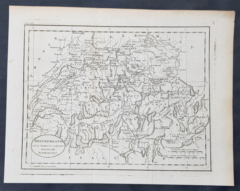
1770 John Cary Original Antique Map of Switzerland
- Title : Switzerland with its Subjects & Allies from the Best Authorities
- Size: 10 1/2in x 8 1/2in (265mm x 215mm)
- Ref #: 70188
- Date : 1770
- Condition: (A+) Fine Condition
Description:
This fine original copper-plate engraved antique map by Thomas Kitchen was published in the 1770 edition of the atlas for William Guthries Geographical Grammar
General Definitions:
Paper thickness and quality: - Heavy and stable
Paper color : - off white
Age of map color: -
Colors used: -
General color appearance: -
Paper size: - 10 1/2in x 8 1/2in (265mm x 215mm)
Plate size: - 10 1/2in x 8 1/2in (265mm x 215mm)
Margins: - Min 1/2in (12mm)
Imperfections:
Margins: - None
Plate area: - Folds as issued
Verso: - None
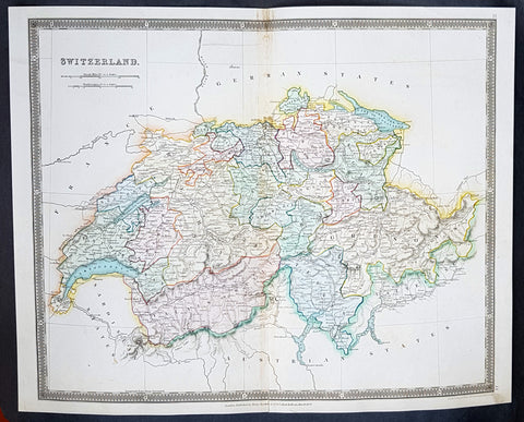
1834 Henry Teesdale Large Antique Map Switzerland divided in Cantons - Beautiful
- Title : 1834 Henry Teesdale Large Antique Map Switzerland divided in Cantons - Beautiful
- Date : 1834
- Condition: (A+) Fine Condition
- Ref: 50286
- Size: 17in x 14in (430mm x 355mm)
Description:
This beautifully hand coloured original steel-plate engraved antique map of Switzerland was engraved by John Dower in 1834 - dated at the foot of the map - and was published in the 1835 edition of Henry Teesdale\'s A New General Atlas of the World.
As with all the maps published by Teesdale this one is of the highest quality on strong clean & sturdy paper with beautiful original hand colouring. (Ref: M&B; Tooley)
General Definitions:
Paper thickness and quality: - Heavy and stable
Paper color : - off white
Age of map color: - Original
Colors used: - Blue, red, yellow, green
General color appearance: - Authentic
Paper size: - 17in x 14in (430mm x 355mm)
Plate size: - 17in x 14in (430mm x 355mm)
Margins: - Min 1/2in (12mm)
Imperfections:
Margins: - None
Plate area: - None
Verso: - None
Background:
The establishment of the Old Swiss Confederacy dates to the late medieval period, resulting from a series of military successes against Austria and Burgundy. Swiss independence from the Holy Roman Empire was formally recognized in the Peace of Westphalia in 1648. The country has a history of armed neutrality going back to the Reformation; it has not been in a state of war internationally since 1815 and did not join the United Nations until 2002. Nevertheless, it pursues an active foreign policy and is frequently involved in peace-building processes around the world. In addition to being the birthplace of the Red Cross, Switzerland is home to numerous international organisations, including the second largest UN office. On the European level, it is a founding member of the European Free Trade Association, but notably not part of the European Union, the European Economic Area or the Eurozone. However, it participates in the Schengen Area and the European Single Market through bilateral treaties.
Spanning the intersection of Germanic and Romance Europe, Switzerland comprises four main linguistic and cultural regions: German, French, Italian and Romansh. Although the majority of the population are German speaking, Swiss national identity is rooted in a common historical background, shared values such as federalism and direct democracy, and Alpine symbolism. Due to its linguistic diversity, Switzerland is known by a variety of native names: Schweiz, Suisse, Svizzera and Svizra. On coins and stamps, the Latin name – frequently shortened to Helvetia – is used instead of the four national languages.
Teesdale & co., Henry fl 1828-1843
Teesdale was a prominent London publisher and founding fellow of the Royal Geographical Society. He produced large-scale maps and charts and a number of fine atlases in the early part of the nineteenth century. He employed the most skilled draftsmen and engravers and his maps are renowned for precise detail and fine coloring