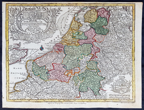
Europe (16)
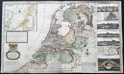
1720 Herman Moll Large Antique Map of The Netherlands - 7 x Town Plans Amsterdam
- Title : A New and Exact Map of the United Provinces, or Netherlands &c. According to the Newest and Most Exact Observations by Herman Moll Geographer
- Size: 41in x 25in (1.04m x 635mm)
- Condition: (A+) Fine Condition
- Date : 1720
- Ref #: 93007
Description:
This very large beautifully hand coloured original copper-plate engraved antique map of The Netherlands by Herman Moll was published in 1720 in the atlas The World Described, or a New and Correct Sett of Maps by John Bowles, Thomas Bowles, Philip Overton & John King of London.
In the 18th century many large-scale maps were published by the likes of John Senex and Herman Moll, this trend continued until the end of private mapping in the early 19th century when it was replaced by Ordnance Survey maps.
General Definitions:
Paper thickness and quality: - Heavy and stable
Paper color : - off white
Age of map color: - Original & later
Colors used: - Blue, pink, red, green, yellow
General color appearance: - Authentic
Paper size: - 41in x 25in (1.02m x 635mm)
Plate size: - 39 1/4in x 24 1/2in (1.00m x 610mm)
Margins: - Min 1/4in (5mm)
Imperfections:
Margins: - Light age toning
Plate area: - Folds as issyed
Verso: - Backed onto contemporary paper
Background:
An attractive, large scale map of The Netherlands or the United Provinces by the highly regarded cartographer and engraver Herman Moll. on the right-hand side views of Amsterdam, Rotterdam, Middelburg, Utrecht, Groningen, Het Loo Palace and a plan of the ancient Roman Castle at the mouth of the Rhine river Arx Britannica (Huis Britten, Brittenberg). The upper left corner of the map has an inset map of the coasts, sands and banks of the North Sea, the stretch of water that lies between England and The Netherlands. Moll dedicates his map to ‘The Right Hon Charles Lord Viscount of Townsend &c one of his Majesty’s Principal Secretaries of State’
This magnificent map was printed by John Bowles of Cornhill, London and published in Moll’s 1719 New and Complete Atlas, but it may also have been separately issued earlier. Moll came to London probably from Bremen around 1678 and by 1688 he had his own shop in Vanley\'s Court in London\'s Blackfriars, between 1691 and 1710 at the corner of Spring Gardens and Charing Cross, when he moved to Beech Street where he remained until his death. In 1701 he published his first work A System of Geography. He was publishing atlases and separately issued maps, and from 1710 was also known as a maker of pocket globes. (Ref: Tooley, Koeman, M&B)
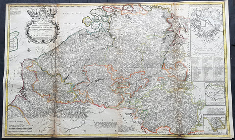
1720 Moll Large Antique Map of The Low Countries, Flanders Netherlands & Belgium
- Title : Les Provinces Des Pays-Bas Catholoiques ou. A Most excat map of Flanders or Austraian Netherlands.....Herman Moll Geogr.
- Size: 40 1/2in x 24in (1.030m x 610mm)
- Condition: (A) Very Good Condition
- Date : 1720
- Ref #: 61130
Description:
This very large beautifully hand coloured original copper-plate engraved antique map of the low country of Flanders region of The Netherlands & Belgium by Herman Moll was published in 1720 in the atlas The World Described, or a New and Correct Sett of Maps by John Bowles, Thomas Bowles, Philip Overton & John King of London.
In the 18th century many large-scale maps were published by the likes of John Senex and Herman Moll, this trend continued until the end of private mapping in the early 19th century when it was replaced by Ordnance Survey maps.
General Definitions:
Paper thickness and quality: - Heavy and stable
Paper color : - off white
Age of map color: - Original
Colors used: - Yellow, green, blue, pink
General color appearance: - Authentic
Paper size: - 40 1/2in x 24in (1.030m x 610mm)
Plate size: - 40in x 24in (1.00m x 610mm)
Margins: - Min 1/2in (12mm)
Imperfections:
Margins: - Age toning along top margin
Plate area: - Age toning along folds
Verso: - Re-enforced & age toning along folds
Background:
Flanders: In 1500, Charles V was born in Ghent. He inherited the Seventeen Provinces (1506), Spain (1516) with its colonies and in 1519 was elected Holy Roman Emperor. The Pragmatic Sanction of 1549, issued by Charles V, established the Low Countries as the Seventeen Provinces (or Spanish Netherlands in its broad sense) as an entity separate from the Holy Roman Empire and from France. In 1556 Charles V abdicated due to ill health (he suffered from crippling gout). Spain and the Seventeen Provinces went to his son, king Philip II of Spain.
Over the first half of the 16th century Antwerp grew to become the second-largest European city north of the Alps by 1560. Antwerp was the richest city in Europe at this time. According to Luc-Normand Tellier It is estimated that the port of Antwerp was earning the Spanish crown seven times more revenues than the Americas.
Meanwhile, Protestantism had reached the Low Countries. Among the wealthy traders of Antwerp, the Lutheran beliefs of the German Hanseatic traders found appeal, perhaps partly for economic reasons. The spread of Protestantism in this city was aided by the presence of an Augustinian cloister (founded 1514) in the St. Andries quarter. Luther, an Augustinian himself, had taught some of the monks, and his works were in print by 1518. The first Lutheran martyrs came from Antwerp. The Reformation resulted in consecutive but overlapping waves of reform: a Lutheran, followed by a militant Anabaptist, then a Mennonite, and finally a Calvinistic movement. These movements existed independently of each other.
Philip II, a devout Catholic and self-proclaimed protector of the Counter-Reformation, suppressed Calvinism in Flanders, Brabant and Holland (what is now approximately Belgian Limburg was part of the Bishopric of Liège and was Catholic de facto). In 1566, the wave of iconoclasm known as the Beeldenstorm was a prelude to religious war between Catholics and Protestants, especially the Anabaptists. The Beeldenstorm started in what is now French Flanders, with open-air sermons (Dutch: hagepreken) that spread through the Low Countries, first to Antwerp and Ghent, and from there further east and north. In total it lasted not even a month.
Subsequently, Philip II sent the Duke of Alba to the Provinces to repress the revolt. Alba recaptured the southern part of the Provinces, who signed the Union of Atrecht, which meant that they would accept the Spanish government on condition of more freedom. But the northern part of the provinces signed the Union of Utrecht and settled in 1581 the Republic of the Seven United Netherlands. Spanish troops quickly started fighting the rebels, but before the revolt could be completely defeated, a war between England and Spain had broken out, forcing Philips Spanish troops to halt their advance. Meanwhile, the Spanish armies had already conquered the important trading cities of Bruges and Ghent. Antwerp, which was then the most important port in the world, also had to be conquered. On 17 August 1585, Antwerp fell. This ended the Eighty Years War for the (from now on) Southern Netherlands. The United Provinces (the Northern Netherlands) fought on until 1648 – the Peace of Westphalia.
While Spain was at war with England, the rebels from the north, strengthened by refugees from the south, started a campaign to reclaim areas lost to Philip IIs Spanish troops. They managed to conquer a considerable part of Brabant (the later Noord-Brabant of the Netherlands), and the south bank of the Scheldt estuary (Zeelandic Flanders), before being stopped by Spanish troops. The front line at the end of this war stabilized and became the current border between present-day Belgium and the Netherlands. The Dutch (as they later became known) had managed to reclaim enough of Spanish-controlled Flanders to close off the river Scheldt, effectively cutting Antwerp off from its trade routes.
First the fall of Antwerp to the Spanish and later also the closing of the Scheldt were causes of a considerable emigration of Antverpians. Many of the Calvinist merchants of Antwerp and also of other Flemish cities left Flanders and emigrated to the north. A large number of them settled in Amsterdam, which was at the time a smaller port, of significance only in the Baltic trade. In the following years Amsterdam was rapidly transformed into one of the worlds most important ports. Because of the contribution of the Flemish exiles to this transformation, the exodus is sometimes described as creating a new Antwerp.
Flanders and Brabant, due to these events, went into a period of relative decline from the time of the Thirty Years War. In the Northern Netherlands however, the mass emigration from Flanders and Brabant became an important driving force behind the Dutch Golden Age.
Although arts remained at a relatively impressive level for another century with Peter Paul Rubens (1577–1640) and Anthony van Dyck, Flanders experienced a loss of its former economic and intellectual power under Spanish, Austrian, and French rule, with heavy taxation and rigid imperial political control compounding the effects of industrial stagnation and Spanish-Dutch and Franco-Austrian conflict. The Southern Netherlands suffered severely under the War of the Spanish Succession, but under the reign of Empress Maria-Theresia these lands economically flourished again. Influenced by the Enlightenment, the Austrian Emperor Joseph II was the first sovereign who had been in the Southern Netherlands since King Philip II of Spain left them in 1559.
In 1794 the French Republican Army started using Antwerp as the northernmost naval port of France, which country officially annexed Flanders the following year as the départements of Lys, Escaut, Deux-Nèthes, Meuse-Inférieure and Dyle. Obligatory (French) army service for all men aged 16–25 was one of the main reasons for the peoples uprising against the French in 1798, known as the Boerenkrijg (Peasants War), with the heaviest fighting in the Campine area.
After the defeat of Napoleon Bonaparte at the 1815 Battle of Waterloo in Waterloo, Brabant, sovereignty over the Austrian Netherlands – Belgium minus the East Cantons and Luxembourg – was given by the Congress of Vienna (1815) to the United Netherlands (Dutch: Verenigde Nederlanden), the state that briefly existed under Sovereign Prince William I of Orange Nassau, the latter King William I of the United Kingdom of the Netherlands, after the French Empire was driven out of the Dutch territories. The United Kingdom of the Netherlands was born. The Protestant King of the Netherlands, William I rapidly started the industrialisation of the southern parts of the Kingdom. The political system that was set up however, slowly but surely failed to forge a true union between the northern and the southern parts of the Kingdom. The southern bourgeoisie mainly was Roman Catholic, in contrast to the mainly Protestant north; large parts of the southern bourgeoisie also primarily spoke French rather than Dutch.
In 1815 the Dutch Senate was reinstated (Dutch: Eerste Kamer der Staaten Generaal). The nobility, mainly coming from the south, became more and more estranged from their northern colleagues. Resentment grew both between the Roman Catholics from the south and the Protestants from the north and among the powerful liberal bourgeoisie from the south and their more moderate colleagues from the north. On 25 August 1830 (after the showing of the opera La Muette de Portici of Daniel Auber in Brussels) the Belgian Revolution sparked off and became a fact. On 4 October 1830, the Provisional Government (Dutch: Voorlopig Bewind) proclaimed the independence, which was later confirmed by the National Congress that issued a new Liberal Constitution and declared the new state a Constitutional Monarchy, under the House of Saxe-Coburg. Flanders now became part of the Kingdom of Belgium, which was recognized by the major European Powers on 20 January 1831. The de facto dissidence was finally recognized by the United Kingdom of the Netherlands on 19 April 1839.
In 1830, the Belgian Revolution led to the splitting up of the two countries. Belgium was confirmed as an independent state by the Treaty of London of 1839, but deprived of the eastern half of Limburg (now Dutch Limburg), and the Eastern half of Luxembourg (now the Grand-Duchy of Luxembourg). Sovereignty over Zeelandic Flanders, south of the Westerscheldt river delta, was left with the Kingdom of the Netherlands, which was allowed to levy a toll on all traffic to Antwerp harbour until 1863.
The Belgian Revolution was not well supported in Flanders and even on 4 October 1830, when the Belgian independence was eventually declared, Flemish authorities refused to take orders from the new Belgian government in Brussels. Only after Flanders was subdued with the aid of a large French military force one month later, under the leadership of the Count de Pontécoulant, did Flanders become a true part of Belgium.
The French-speaking bourgeoisie showed very little respect for the Dutch-speaking part of the population. French became the only official language in Belgium and all secondary and higher education in the Dutch language was abolished.
In 1834, all people even remotely suspected of being Flemish minded or calling for the reunification of the Netherlands were prosecuted and their houses looted and burnt. Flanders, until then a very prosperous European region, was not considered worthwhile for investment and scholarship. A study in 1918 demonstrated that in the first 88 years of its existence, 80% of the Belgian GNP was invested in Wallonia. This led to a widespread poverty in Flanders, forcing roughly 300.000 Flemish to emigrate to Wallonia to start working there in the heavy industry.John SenexMoll
All of these events led to a silent uprising in Flanders against the French-speaking domination. But it was not until 1878 that Dutch was allowed to be used for official purposes in Flanders (see language legislation in Belgium), although French remained the only official language in Belgium.
In 1873, Dutch became the official language in public secondary schools. In 1898 Dutch and French were declared equal languages in laws and Royal orders. In 1930 the first Flemish university was opened. The first official translation of the Belgian constitution in Dutch was not published until 1967.
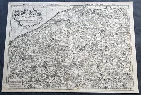
1692 Alexis Jaillot Large Antique Map Flanders Region of Netherlands & Belgium
- Title : Le Comte De Flandre Divisee en ses Chastellenie, Balliages &c.....1692
- Size: 34in x 24in (865mm x 610mm)
- Condition: (B) Good Condition
- Date : 1692
- Ref #: 16384
Description:
This very large, hand coloured original antique map of Flanders region of The Netherlands and Belgium, by Alexis Hubert Jaillot - after Nicolas Sanson - was engraved in 1692 - the date is engraved in the title cartouche.
This large highly detailed map centers on the Brugge to the north, south to Douay west to Dunkirk and east to Dendermonde.
General Definitions:
Paper thickness and quality: - Heavy and stable
Paper color : - off white
Age of map color: - Original
Colors used: - Yellow, green, blue, pink
General color appearance: - Authentic
Paper size: - 34in x 24in (865mm x 610mm)
Plate size: - 33in x 23in (855mm x 600mm)
Margins: - Min 1/2in (12mm)
Imperfections:
Margins: - Soiling and creasing in margins
Plate area: - Light uplift along centerfold, light soiling
Verso: - Soiling and creasing
Background:
Flanders: In 1500, Charles V was born in Ghent. He inherited the Seventeen Provinces (1506), Spain (1516) with its colonies and in 1519 was elected Holy Roman Emperor. The Pragmatic Sanction of 1549, issued by Charles V, established the Low Countries as the Seventeen Provinces (or Spanish Netherlands in its broad sense) as an entity separate from the Holy Roman Empire and from France. In 1556 Charles V abdicated due to ill health (he suffered from crippling gout). Spain and the Seventeen Provinces went to his son, king Philip II of Spain.
Over the first half of the 16th century Antwerp grew to become the second-largest European city north of the Alps by 1560. Antwerp was the richest city in Europe at this time. According to Luc-Normand Tellier It is estimated that the port of Antwerp was earning the Spanish crown seven times more revenues than the Americas.
Meanwhile, Protestantism had reached the Low Countries. Among the wealthy traders of Antwerp, the Lutheran beliefs of the German Hanseatic traders found appeal, perhaps partly for economic reasons. The spread of Protestantism in this city was aided by the presence of an Augustinian cloister (founded 1514) in the St. Andries quarter. Luther, an Augustinian himself, had taught some of the monks, and his works were in print by 1518. The first Lutheran martyrs came from Antwerp. The Reformation resulted in consecutive but overlapping waves of reform: a Lutheran, followed by a militant Anabaptist, then a Mennonite, and finally a Calvinistic movement. These movements existed independently of each other.
Philip II, a devout Catholic and self-proclaimed protector of the Counter-Reformation, suppressed Calvinism in Flanders, Brabant and Holland (what is now approximately Belgian Limburg was part of the Bishopric of Liège and was Catholic de facto). In 1566, the wave of iconoclasm known as the Beeldenstorm was a prelude to religious war between Catholics and Protestants, especially the Anabaptists. The Beeldenstorm started in what is now French Flanders, with open-air sermons (Dutch: hagepreken) that spread through the Low Countries, first to Antwerp and Ghent, and from there further east and north. In total it lasted not even a month.
Subsequently, Philip II sent the Duke of Alba to the Provinces to repress the revolt. Alba recaptured the southern part of the Provinces, who signed the Union of Atrecht, which meant that they would accept the Spanish government on condition of more freedom. But the northern part of the provinces signed the Union of Utrecht and settled in 1581 the Republic of the Seven United Netherlands. Spanish troops quickly started fighting the rebels, but before the revolt could be completely defeated, a war between England and Spain had broken out, forcing Philips Spanish troops to halt their advance. Meanwhile, the Spanish armies had already conquered the important trading cities of Bruges and Ghent. Antwerp, which was then the most important port in the world, also had to be conquered. On 17 August 1585, Antwerp fell. This ended the Eighty Years War for the (from now on) Southern Netherlands. The United Provinces (the Northern Netherlands) fought on until 1648 – the Peace of Westphalia.
While Spain was at war with England, the rebels from the north, strengthened by refugees from the south, started a campaign to reclaim areas lost to Philip IIs Spanish troops. They managed to conquer a considerable part of Brabant (the later Noord-Brabant of the Netherlands), and the south bank of the Scheldt estuary (Zeelandic Flanders), before being stopped by Spanish troops. The front line at the end of this war stabilized and became the current border between present-day Belgium and the Netherlands. The Dutch (as they later became known) had managed to reclaim enough of Spanish-controlled Flanders to close off the river Scheldt, effectively cutting Antwerp off from its trade routes.
First the fall of Antwerp to the Spanish and later also the closing of the Scheldt were causes of a considerable emigration of Antverpians. Many of the Calvinist merchants of Antwerp and also of other Flemish cities left Flanders and emigrated to the north. A large number of them settled in Amsterdam, which was at the time a smaller port, of significance only in the Baltic trade. In the following years Amsterdam was rapidly transformed into one of the worlds most important ports. Because of the contribution of the Flemish exiles to this transformation, the exodus is sometimes described as creating a new Antwerp.
Flanders and Brabant, due to these events, went into a period of relative decline from the time of the Thirty Years War. In the Northern Netherlands however, the mass emigration from Flanders and Brabant became an important driving force behind the Dutch Golden Age.
Although arts remained at a relatively impressive level for another century with Peter Paul Rubens (1577–1640) and Anthony van Dyck, Flanders experienced a loss of its former economic and intellectual power under Spanish, Austrian, and French rule, with heavy taxation and rigid imperial political control compounding the effects of industrial stagnation and Spanish-Dutch and Franco-Austrian conflict. The Southern Netherlands suffered severely under the War of the Spanish Succession, but under the reign of Empress Maria-Theresia these lands economically flourished again. Influenced by the Enlightenment, the Austrian Emperor Joseph II was the first sovereign who had been in the Southern Netherlands since King Philip II of Spain left them in 1559.
In 1794 the French Republican Army started using Antwerp as the northernmost naval port of France, which country officially annexed Flanders the following year as the départements of Lys, Escaut, Deux-Nèthes, Meuse-Inférieure and Dyle. Obligatory (French) army service for all men aged 16–25 was one of the main reasons for the peoples uprising against the French in 1798, known as the Boerenkrijg (Peasants War), with the heaviest fighting in the Campine area.
After the defeat of Napoleon Bonaparte at the 1815 Battle of Waterloo in Waterloo, Brabant, sovereignty over the Austrian Netherlands – Belgium minus the East Cantons and Luxembourg – was given by the Congress of Vienna (1815) to the United Netherlands (Dutch: Verenigde Nederlanden), the state that briefly existed under Sovereign Prince William I of Orange Nassau, the latter King William I of the United Kingdom of the Netherlands, after the French Empire was driven out of the Dutch territories. The United Kingdom of the Netherlands was born. The Protestant King of the Netherlands, William I rapidly started the industrialisation of the southern parts of the Kingdom. The political system that was set up however, slowly but surely failed to forge a true union between the northern and the southern parts of the Kingdom. The southern bourgeoisie mainly was Roman Catholic, in contrast to the mainly Protestant north; large parts of the southern bourgeoisie also primarily spoke French rather than Dutch.
In 1815 the Dutch Senate was reinstated (Dutch: Eerste Kamer der Staaten Generaal). The nobility, mainly coming from the south, became more and more estranged from their northern colleagues. Resentment grew both between the Roman Catholics from the south and the Protestants from the north and among the powerful liberal bourgeoisie from the south and their more moderate colleagues from the north. On 25 August 1830 (after the showing of the opera La Muette de Portici of Daniel Auber in Brussels) the Belgian Revolution sparked off and became a fact. On 4 October 1830, the Provisional Government (Dutch: Voorlopig Bewind) proclaimed the independence, which was later confirmed by the National Congress that issued a new Liberal Constitution and declared the new state a Constitutional Monarchy, under the House of Saxe-Coburg. Flanders now became part of the Kingdom of Belgium, which was recognized by the major European Powers on 20 January 1831. The de facto dissidence was finally recognized by the United Kingdom of the Netherlands on 19 April 1839.
In 1830, the Belgian Revolution led to the splitting up of the two countries. Belgium was confirmed as an independent state by the Treaty of London of 1839, but deprived of the eastern half of Limburg (now Dutch Limburg), and the Eastern half of Luxembourg (now the Grand-Duchy of Luxembourg). Sovereignty over Zeelandic Flanders, south of the Westerscheldt river delta, was left with the Kingdom of the Netherlands, which was allowed to levy a toll on all traffic to Antwerp harbour until 1863.
The Belgian Revolution was not well supported in Flanders and even on 4 October 1830, when the Belgian independence was eventually declared, Flemish authorities refused to take orders from the new Belgian government in Brussels. Only after Flanders was subdued with the aid of a large French military force one month later, under the leadership of the Count de Pontécoulant, did Flanders become a true part of Belgium.
The French-speaking bourgeoisie showed very little respect for the Dutch-speaking part of the population. French became the only official language in Belgium and all secondary and higher education in the Dutch language was abolished.
In 1834, all people even remotely suspected of being Flemish minded or calling for the reunification of the Netherlands were prosecuted and their houses looted and burnt. Flanders, until then a very prosperous European region, was not considered worthwhile for investment and scholarship. A study in 1918 demonstrated that in the first 88 years of its existence, 80% of the Belgian GNP was invested in Wallonia. This led to a widespread poverty in Flanders, forcing roughly 300.000 Flemish to emigrate to Wallonia to start working there in the heavy industry.
All of these events led to a silent uprising in Flanders against the French-speaking domination. But it was not until 1878 that Dutch was allowed to be used for official purposes in Flanders (see language legislation in Belgium), although French remained the only official language in Belgium.
In 1873, Dutch became the official language in public secondary schools. In 1898 Dutch and French were declared equal languages in laws and Royal orders. In 1930 the first Flemish university was opened. The first official translation of the Belgian constitution in Dutch was not published until 1967.
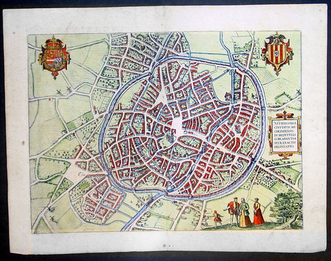
1575 Braun & Hogenberg Large Antique Print a View of Mechelen, Belgium
- Title : Mechelen - Nitidissimae Civitatis Mechlineensis in meditullio Brabantiae sitae, exactis: delineatio
- Ref #: 16247
- Size: 21in x 16in (535mm x 410mm)
- Date : 1575
- Condition: (A+) Fine Condition
Description:
This fine beautifully hand coloured original antique map a birds-eye view of the city of Mechelen in the Antwerp province of Flanders, Belgium was published by Georg Braun & Frans Hogenberg for the 1575 atlas of town plans Civiates Orbis Terrarum Vol II (1572-1612) intended as a companion to Abraham Ortelius's master Atlas Theatrum Orbis Terrarum published in 1570.
Franz Hogenberg's birthplace is illustrated twice. In the view presented in Volume I the cityscape is dominated by the massive tower belonging to the cathedral of Sint-Rombout, which measures almost 100 m in height. Behind the cathedral to the right lies the Onze-Lieve-Vrouwe church built in the Brabantine late Gothic style. In the present plate Mechelen is seen in a bird's-eye view from the northwest. Clearly apparent is the almost circular shape of the inner city, which has already spread beyond the bounds of the canal ringing the old city wall. In the Middle Ages staple rights and the cloth trade brought Mechelen great prosperity. In 1336 the city passed to the Duchy of Brabant, later to Burgundy, and developed into a highly regarded centre of commerce. The collapse of the cloth industry prompted the development of new areas of manufacturing, such as cannon and bell founding. In 1477 Mechelen passed to the Habsburgs and from 1507 to 1530, under the regency of Margaret of Austria, was capital of the Habsburg Netherlands. In 1559 Mechelen became an archbishopric and over the course of the Wars of Religion grew into a centre of the Counter-Reformation. For some time it was also the seat of the highest tribunal of the Habsburg Netherlands. (Taschen)
Background of Civitates Orbis Terrarum
The first volume of the Civitates Orbis Terrarum was published in Cologne in 1572. The sixth and the final volume appeared in 1617.
This great city atlas, edited by Georg Braun and largely engraved by Franz Hogenberg, eventually contained 546 prospects, bird-eye views and map views of cities from all over the world. Braun (1541-1622), a cleric of Cologne, was the principal editor of the work, and was greatly assisted in his project by the close, and continued interest of Abraham Ortelius, whose Theatrum Orbis Terrarum of 1570 was, as a systematic and comprehensive collection of maps of uniform style, the first true atlas.
For a variety of reasons town plans were comparatively latecomers in the long history of cartography. Few cities in Europe in the middle ages had more than 20,00 inhabitants and even London in the late Elizabethan period had only 100-150,000 people which in itself was probably 10 times that of any other English city. The Nuremberg Chronicle in 1493 included one of the first town views of Jerusalem, thereafter, for most of the sixteenth century, German cartographers led the way in producing town plans in a modern sense. In 1544 Sebastian Munster issued in Basle his Cosmographia containing roughly sixty-six plans and views, some in the plan form, but many in the old panorama or birds eye view. (Ref: Tooley; M&B)
Condition Report:
Paper thickness and quality: - Heavy and stable
Paper color: - off white
Age of map color: - Early
Colors used: - Green, blue, red, yellow
General color appearance: - Authentic
Paper size: - 21in x 16in (535mm x 410mm)
Plate size: - 18 1/2in x 13 1/2in (470mm x 345mm)
Margins: - Min 1in (25mm)
Imperfections:
Margins: - Light soiling in margins
Plate area: - None
Verso: - None
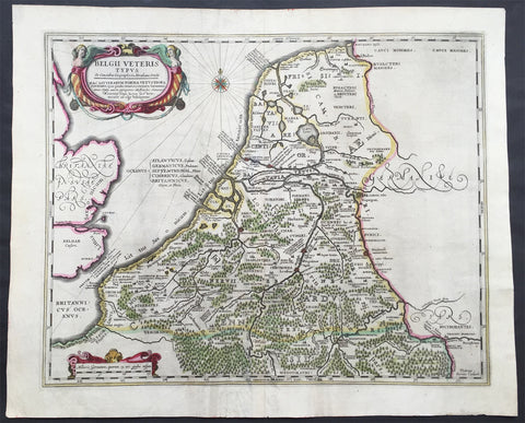
1638 Jansson Large Antique Map of The Netherlands & Belgium
- Title : Belgii Veteris Typus...Abrahami Ortelii...Petrus Karius
- Ref #: 61036
- Size: 21 1/2in x 17 1/2in (545mm x 445mm)
- Date : 1638
- Condition: (A) Very Good Condition
Description:
This large beautifully hand coloured original antique map of The Netherlands & Belgium was engraved by Peter Karius and was published in the 1638 Latin edition of Mercator's Atlas published by Henricus Hondius and Jan Jansson. (Ref: Koeman; M&B; Tooley)
Condition Report:
Paper thickness and quality: - Heavy and stable
Paper color: - off white
Age of map color: - Original
Colors used: - Yellow, pink, green
General color appearance: - Authentic
Paper size: - 21 1/2in x 17 1/2in (545mm x 445mm)
Plate size: - 19in x 15 1/2in (480mm x 395mm)
Margins: - Min 1in (25mm)
Imperfections:
Margins: - Light creasing in bottom margin
Plate area: - Centerfold Re-joined
Verso: - Soiling
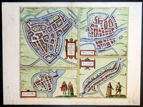
1575 Braun & Hogenberg Antique Print Sneek Dokkum Ylst Frisia Sloten Netherlands
- Title : Sneecha, vulgo Sneeck Frisiae Occidentalis Oppidum. - Doccum - Sloten - Ylsta
- Ref #: 30261
- Size: 21in x 16in (535mm x 410mm)
- Date : 1575
- Condition: (A+) Fine Condition
Description:
This fine beautifully hand coloured original antique map a birds-eye view of the towns of Sneek, Dokkum, Ylst and Sloten in Frisia, the Netherlands was published by Georg Braun & Frans Hogenberg for the 1575 atlas of town plans Civiates Orbis Terrarum Vol II (1572-1612) intended as a companion to Abraham Ortelius's master Atlas Theatrum Orbis Terrarum published in 1570.
Background of Civitates Orbis Terrarum
The first volume of the Civitates Orbis Terrarum was published in Cologne in 1572. The sixth and the final volume appeared in 1617.
This great city atlas, edited by Georg Braun and largely engraved by Franz Hogenberg, eventually contained 546 prospects, bird-eye views and map views of cities from all over the world. Braun (1541-1622), a cleric of Cologne, was the principal editor of the work, and was greatly assisted in his project by the close, and continued interest of Abraham Ortelius, whose Theatrum Orbis Terrarum of 1570 was, as a systematic and comprehensive collection of maps of uniform style, the first true atlas.
For a variety of reasons town plans were comparatively latecomers in the long history of cartography. Few cities in Europe in the middle ages had more than 20,00 inhabitants and even London in the late Elizabethan period had only 100-150,000 people which in itself was probably 10 times that of any other English city. The Nuremberg Chronicle in 1493 included one of the first town views of Jerusalem, thereafter, for most of the sixteenth century, German cartographers led the way in producing town plans in a modern sense. In 1544 Sebastian Munster issued in Basle his Cosmographia containing roughly sixty-six plans and views, some in the plan form, but many in the old panorama or birds eye view. (Ref: Tooley; M&B)
Condition Report:
Paper thickness and quality: - Heavy and stable
Paper color: - off white
Age of map color: - Early
Colors used: - Green, blue, red, yellow
General color appearance: - Authentic
Paper size: - 21in x 16in (535mm x 410mm)
Plate size: - 16 1/2in x 14in (420mm x 355mm)
Margins: - Min 1in (25mm)
Imperfections:
Margins: - Light soiling in margins
Plate area: - None
Verso: - None
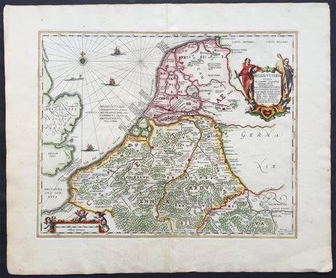
1652 Jansson Large Old, Antique Map of The Netherlands
- Title : Belgii Veteris
- Ref #: 80696
- Size: 24in x 19 1/2in (610mm x 495mm)
- Date : 1652
- Condition: (A+) Fine Condition
Description:
This beautifully engraved hand coloured original antique map of Belgium & the Netherlands was published by Jan Jansson in the 1652 edition of Accuratissima Orbis Antiqui Delineatio.
The cartographical information from this map was borrowed from the Abraham Ortelius map Daciarum Moesiarum first published inParergon in 1595. (Ref: Koeman; Tooley)
General Description:
Paper thickness and quality: - Heavy and stable
Paper color: - off white
Age of map color: - Later
Colors used: - Green, red, orange, yellow, blue
General color appearance: - Authentic and beautiful
Paper size: - 24in x 19 1/2in (610mm x 495mm)
Plate size: - 19in x 14 1/2in (485mm x 370mm)
Margins: - Min 1in (25mm)
Imperfections:
Margins: - None
Plate area: - None
Verso: - None

1720 Moll Large Antique Map of The Low Countries, Flanders Netherlands & Belgium
- Title : Les Provinces Des Pays-Bas Catholoiques ou. A Most excat map of Flanders or Austraian Netherlands.....Herman Moll Geogr.
- Size: 40 1/2in x 24in (1.030m x 610mm)
- Condition: (A) Very Good Condition
- Date : 1720
- Ref #: 61130
Description:
This very large beautifully hand coloured original copper-plate engraved antique map of the low country of Flanders region of The Netherlands & Belgium by Herman Moll was published in 1720 in the atlas The World Described, or a New and Correct Sett of Maps by John Bowles, Thomas Bowles, Philip Overton & John King of London.
In the 18th century many large-scale maps were published by the likes of John Senex and Herman Moll, this trend continued until the end of private mapping in the early 19th century when it was replaced by Ordnance Survey maps.
General Definitions:
Paper thickness and quality: - Heavy and stable
Paper color : - off white
Age of map color: - Original
Colors used: - Yellow, green, blue, pink
General color appearance: - Authentic
Paper size: - 40 1/2in x 24in (1.030m x 610mm)
Plate size: - 40in x 24in (1.00m x 610mm)
Margins: - Min 1/2in (12mm)
Imperfections:
Margins: - Age toning along top margin
Plate area: - Age toning along folds
Verso: - Re-enforced & age toning along folds
Background:
Flanders: In 1500, Charles V was born in Ghent. He inherited the Seventeen Provinces (1506), Spain (1516) with its colonies and in 1519 was elected Holy Roman Emperor. The Pragmatic Sanction of 1549, issued by Charles V, established the Low Countries as the Seventeen Provinces (or Spanish Netherlands in its broad sense) as an entity separate from the Holy Roman Empire and from France. In 1556 Charles V abdicated due to ill health (he suffered from crippling gout). Spain and the Seventeen Provinces went to his son, king Philip II of Spain.
Over the first half of the 16th century Antwerp grew to become the second-largest European city north of the Alps by 1560. Antwerp was the richest city in Europe at this time. According to Luc-Normand Tellier It is estimated that the port of Antwerp was earning the Spanish crown seven times more revenues than the Americas.
Meanwhile, Protestantism had reached the Low Countries. Among the wealthy traders of Antwerp, the Lutheran beliefs of the German Hanseatic traders found appeal, perhaps partly for economic reasons. The spread of Protestantism in this city was aided by the presence of an Augustinian cloister (founded 1514) in the St. Andries quarter. Luther, an Augustinian himself, had taught some of the monks, and his works were in print by 1518. The first Lutheran martyrs came from Antwerp. The Reformation resulted in consecutive but overlapping waves of reform: a Lutheran, followed by a militant Anabaptist, then a Mennonite, and finally a Calvinistic movement. These movements existed independently of each other.
Philip II, a devout Catholic and self-proclaimed protector of the Counter-Reformation, suppressed Calvinism in Flanders, Brabant and Holland (what is now approximately Belgian Limburg was part of the Bishopric of Liège and was Catholic de facto). In 1566, the wave of iconoclasm known as the Beeldenstorm was a prelude to religious war between Catholics and Protestants, especially the Anabaptists. The Beeldenstorm started in what is now French Flanders, with open-air sermons (Dutch: hagepreken) that spread through the Low Countries, first to Antwerp and Ghent, and from there further east and north. In total it lasted not even a month.
Subsequently, Philip II sent the Duke of Alba to the Provinces to repress the revolt. Alba recaptured the southern part of the Provinces, who signed the Union of Atrecht, which meant that they would accept the Spanish government on condition of more freedom. But the northern part of the provinces signed the Union of Utrecht and settled in 1581 the Republic of the Seven United Netherlands. Spanish troops quickly started fighting the rebels, but before the revolt could be completely defeated, a war between England and Spain had broken out, forcing Philips Spanish troops to halt their advance. Meanwhile, the Spanish armies had already conquered the important trading cities of Bruges and Ghent. Antwerp, which was then the most important port in the world, also had to be conquered. On 17 August 1585, Antwerp fell. This ended the Eighty Years War for the (from now on) Southern Netherlands. The United Provinces (the Northern Netherlands) fought on until 1648 – the Peace of Westphalia.
While Spain was at war with England, the rebels from the north, strengthened by refugees from the south, started a campaign to reclaim areas lost to Philip IIs Spanish troops. They managed to conquer a considerable part of Brabant (the later Noord-Brabant of the Netherlands), and the south bank of the Scheldt estuary (Zeelandic Flanders), before being stopped by Spanish troops. The front line at the end of this war stabilized and became the current border between present-day Belgium and the Netherlands. The Dutch (as they later became known) had managed to reclaim enough of Spanish-controlled Flanders to close off the river Scheldt, effectively cutting Antwerp off from its trade routes.
First the fall of Antwerp to the Spanish and later also the closing of the Scheldt were causes of a considerable emigration of Antverpians. Many of the Calvinist merchants of Antwerp and also of other Flemish cities left Flanders and emigrated to the north. A large number of them settled in Amsterdam, which was at the time a smaller port, of significance only in the Baltic trade. In the following years Amsterdam was rapidly transformed into one of the worlds most important ports. Because of the contribution of the Flemish exiles to this transformation, the exodus is sometimes described as creating a new Antwerp.
Flanders and Brabant, due to these events, went into a period of relative decline from the time of the Thirty Years War. In the Northern Netherlands however, the mass emigration from Flanders and Brabant became an important driving force behind the Dutch Golden Age.
Although arts remained at a relatively impressive level for another century with Peter Paul Rubens (1577–1640) and Anthony van Dyck, Flanders experienced a loss of its former economic and intellectual power under Spanish, Austrian, and French rule, with heavy taxation and rigid imperial political control compounding the effects of industrial stagnation and Spanish-Dutch and Franco-Austrian conflict. The Southern Netherlands suffered severely under the War of the Spanish Succession, but under the reign of Empress Maria-Theresia these lands economically flourished again. Influenced by the Enlightenment, the Austrian Emperor Joseph II was the first sovereign who had been in the Southern Netherlands since King Philip II of Spain left them in 1559.
In 1794 the French Republican Army started using Antwerp as the northernmost naval port of France, which country officially annexed Flanders the following year as the départements of Lys, Escaut, Deux-Nèthes, Meuse-Inférieure and Dyle. Obligatory (French) army service for all men aged 16–25 was one of the main reasons for the peoples uprising against the French in 1798, known as the Boerenkrijg (Peasants War), with the heaviest fighting in the Campine area.
After the defeat of Napoleon Bonaparte at the 1815 Battle of Waterloo in Waterloo, Brabant, sovereignty over the Austrian Netherlands – Belgium minus the East Cantons and Luxembourg – was given by the Congress of Vienna (1815) to the United Netherlands (Dutch: Verenigde Nederlanden), the state that briefly existed under Sovereign Prince William I of Orange Nassau, the latter King William I of the United Kingdom of the Netherlands, after the French Empire was driven out of the Dutch territories. The United Kingdom of the Netherlands was born. The Protestant King of the Netherlands, William I rapidly started the industrialisation of the southern parts of the Kingdom. The political system that was set up however, slowly but surely failed to forge a true union between the northern and the southern parts of the Kingdom. The southern bourgeoisie mainly was Roman Catholic, in contrast to the mainly Protestant north; large parts of the southern bourgeoisie also primarily spoke French rather than Dutch.
In 1815 the Dutch Senate was reinstated (Dutch: Eerste Kamer der Staaten Generaal). The nobility, mainly coming from the south, became more and more estranged from their northern colleagues. Resentment grew both between the Roman Catholics from the south and the Protestants from the north and among the powerful liberal bourgeoisie from the south and their more moderate colleagues from the north. On 25 August 1830 (after the showing of the opera La Muette de Portici of Daniel Auber in Brussels) the Belgian Revolution sparked off and became a fact. On 4 October 1830, the Provisional Government (Dutch: Voorlopig Bewind) proclaimed the independence, which was later confirmed by the National Congress that issued a new Liberal Constitution and declared the new state a Constitutional Monarchy, under the House of Saxe-Coburg. Flanders now became part of the Kingdom of Belgium, which was recognized by the major European Powers on 20 January 1831. The de facto dissidence was finally recognized by the United Kingdom of the Netherlands on 19 April 1839.
In 1830, the Belgian Revolution led to the splitting up of the two countries. Belgium was confirmed as an independent state by the Treaty of London of 1839, but deprived of the eastern half of Limburg (now Dutch Limburg), and the Eastern half of Luxembourg (now the Grand-Duchy of Luxembourg). Sovereignty over Zeelandic Flanders, south of the Westerscheldt river delta, was left with the Kingdom of the Netherlands, which was allowed to levy a toll on all traffic to Antwerp harbour until 1863.
The Belgian Revolution was not well supported in Flanders and even on 4 October 1830, when the Belgian independence was eventually declared, Flemish authorities refused to take orders from the new Belgian government in Brussels. Only after Flanders was subdued with the aid of a large French military force one month later, under the leadership of the Count de Pontécoulant, did Flanders become a true part of Belgium.
The French-speaking bourgeoisie showed very little respect for the Dutch-speaking part of the population. French became the only official language in Belgium and all secondary and higher education in the Dutch language was abolished.
In 1834, all people even remotely suspected of being Flemish minded or calling for the reunification of the Netherlands were prosecuted and their houses looted and burnt. Flanders, until then a very prosperous European region, was not considered worthwhile for investment and scholarship. A study in 1918 demonstrated that in the first 88 years of its existence, 80% of the Belgian GNP was invested in Wallonia. This led to a widespread poverty in Flanders, forcing roughly 300.000 Flemish to emigrate to Wallonia to start working there in the heavy industry.John SenexMoll
All of these events led to a silent uprising in Flanders against the French-speaking domination. But it was not until 1878 that Dutch was allowed to be used for official purposes in Flanders (see language legislation in Belgium), although French remained the only official language in Belgium.
In 1873, Dutch became the official language in public secondary schools. In 1898 Dutch and French were declared equal languages in laws and Royal orders. In 1930 the first Flemish university was opened. The first official translation of the Belgian constitution in Dutch was not published until 1967.
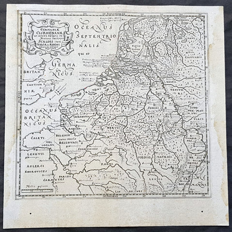
1611 Philipp Cluver Antique Map The Netherlands, Belgium, parts France & Germany
- Title : Germaniae Cisrhenanae ut interl. caesaris et Traiani suit imperii Scaldis item Mosae ac Rheni ostiorum antiqua Descriptio
- Size: 11 1/2in x 11 1/2in (295mm x 295mm)
- Condition: (A+) Fine Condition
- Date : 1611
- Ref #: 23967
Description:
This fine original wood-block engraved antique map of The Netherlands, Belgium, Northern France and parts of Western Germany was published in the 1611 edition of Philip Cluvers first publication Commentarius de tribus Rheni alveis, et ostiis; item. De Quinque populis quondam accolis; scilicet de Toxandris, Batavis, Caninefatibus, Frisiis, ac Marsacis. (Ref: King; Tooley; M&B)
General Definitions:
Paper thickness and quality: - Heavy and stable
Paper color : - off white
Age of map color: -
Colors used: -
General color appearance: -
Paper size: - 11 1/2in x 11 1/2in (295mm x 295mm)
Plate size: - 10in x 10in (255mm x 255mm)
Margins: - Min 1/2in (12mm)
Imperfections:
Margins: - Light age toning to left & right margins
Plate area: - None
Verso: - None
Background:
Clüver was an antiquary, who was given a special appointment at Leiden as geographer and put in charge of the university\'s library, but his lifes project, it developed, was a general study of the geography of Antiquity, based not only on classical literary sources, but — and this was his contribution — supplemented by wide travels and local inspections. He became virtually the founder of historical geography.
Clüvers first work, in 1611, concerning the lower reaches of the Rhine and its tribal inhabitants in Roman times (Commentarius de tribus Rheni alveis, et ostiis; item. De Quinque populis quondam accolis; scilicet de Toxandris, Batavis, Caninefatibus, Frisiis, ac Marsacis) touched a source of national pride among the Seventeen Provinces, for the Dutch were enjoying a twelve years truce in their Eighty Years War of liberation.
Cluver, Philipp 1580 – 1622
Clüver - also Klüwer, Cluwer, or Cluvier, Latinized as Philippus Cluverius and Philippi Cluverii) - was an Early Modern German geographer and historian.
Clüver was born in Danzig (Gdańsk), in Royal Prussia, a province of the Kingdom of Poland. After spending some time at the Polish court of Sigismund III Vasa, he began the study of law at the University of Leiden (Dutch Republic), but soon he turned his attention to history and geography, which were then taught there by Joseph Scaliger.
Clüver received science education from his father, who was Münzmeister at Danzig (coin master), but when Clüver went into different studies, his father stopped supporting his studies. He therefore travelled from Leiden across Hungary to Bohemia, where he did military service for a few years. While in Bohemia, he translated into Latin a defense by Baron Popel Lobkowitz, who was imprisoned. Upon his return to Leiden, he faced sanctions by the imperial (Habsburg) authorities for this, which however he could avoid with the help of his Leiden friends.
Clüver also travelled in England, Scotland, and France. He did all travel on foot, finally returning to Leiden, where (after 1616) he received a regular pension from the university. He died in Leiden.
Clüver was an antiquary, who was given a special appointment at Leiden as geographer and put in charge of the university\\\'s library, but his lifes project, it developed, was a general study of the geography of Antiquity, based not only on classical literary sources, but — and this was his contribution — supplemented by wide travels and local inspections. He became virtually the founder of historical geography.
Clüver\\\'s first work, in 1611, concerning the lower reaches of the Rhine and its tribal inhabitants in Roman times (Commentarius de tribus Rheni alveis, et ostiis; item. De Quinque populis quondam accolis; scilicet de Toxandris, Batavis, Caninefatibus, Frisiis, ac Marsacis) touched a source of national pride among the Seventeen Provinces, for the Dutch were enjoying a twelve years\\\' truce in their Eighty Years War of liberation.
Clüvers Germaniae antiquae libri tres (Leiden, 1616) depends on Tacitus and other Latin authors. A volume on the antiquities of Sicily, with notes on Sardinia and Corsica (Sicilia Antiqua cum minoribus insulis ei adjacentibus item Sardinia et Corsica), published at Leiden by Louis Elsevier in 1619, is a useful source, with many reference from writers of Antiquity and maps that are often detached and sold to map collectors. His Introductio in universam geographiam, totally 6 parts, (published posthumously from 1624) was the first comprehensive modern geography, and became a standard geographical textbook.
Clüver was also a prolific a writer on mathematical and theological subjects. He is remembered by collectors and historians of cartography for his edition of Ptolemys Geographia (based on Mercators edition of 1578) and for miniature atlases that were reprinted for most of the 17th century. Many of his maps were etched for him by Petrus Bertius.
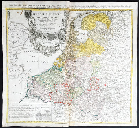
1748 Homann, Mayer Large Old, Antique Map of The Netherlands, Belgium, Holland
- Title : Belgii Universi seu Inferioris Germaniae quam XVII Provinciae Austriaco, Gallico et Batavo sceptro parentes constituunt nova Tabula Geographica a Tobia Majero Math. Cult. ad leges legitimae delineationis revocata Cura et studio Homanniorum Heredum A. 1748
- Ref #: 16422
- Size: 21 1/2in x 20in (545mm x 510mm)
- Date : 1748
- Condition: (A) Very Good Condition
Description:
This large beautifully hand coloured original antique map* of Holland, The Netherlands and Belgium was engraved in 1748 byJohann Tobias Mayer - dated in Title - and was published by Homann firm in 1750.
Background: A beautifully detailed 1748 Homann Heirs map of Belgium and the Netherlands (Holland). Includes Belgium proper as well as the seven states of the Belgian Federation – what is today Holland or the Netherlands. Also includes parts of England and extends into eastern Germany past the Rhine River.
Title elaborate cartouche in the upper left quadrant, filling the North Sea, features the armorial shields of the Belgian Counties as well as those of the seven states of the federation: Geldern, Holland, Zeeland, Utrecht, Friesland, Ober Issel, and Groningen.
This map was drawn by Johann Tobias Mayer for inclusion the 1752 Homann Heirs Maior Atlas Scholasticus ex Triginta Sex Generalibus et Specialibus…. Most early Homann atlases were 'made to order' or compiled of individual maps at the request of the buyer. However, this rare atlas, composed of 37 maps and charts, was issued as a 'suggested collection' of essential Homann Heirs maps. (Ref: Tooley; M&B)
General Description:
Paper thickness and quality: - Heavy and stable
Paper color: - off white
Age of map color: - Original
Colors used: - Yellow, green, blue, pink
General color appearance: - Authentic
Paper size: - 21 1/2in x 20in (545mm x 510mm)
Plate size: - 21in x 19 1/2in (535mm x 495mm)
Margins: - Min 1/2in (12mm)
Imperfections:
Margins: - None
Plate area: - Light creasing along centrefold
Verso: - Re-enforced along centrefold

1647 Olivarius Vredius Antique Map of Roman Europe Flanders, Germany, France
- Title : Francorum Primae Sedes...Incisum Bruges a Joe F Jois...Olivario Vredio...1647
- Ref #: 60040
- Size: 16 1/2in x 14in (420mm x 355mm)
- Date : 1647
- Condition: (A+) Fine Condition
Description:
This fine scarce beautifully engraved original antique map of central & western Roman Europe centering on what is today Belgium, the Southern Netherlands, Northern France and Western Germany - was engraved in 1647 - dated - and published by Olivarius Vredius (Olivier de Wree)in the 1652 edition of Historiae Comitum Flandriae
Historiae Comitum Flandriae was an important historical work on the origin and early history of Flanders by the well-known historian Olivarius Vredius - Olivier de Wree - (1596-1652) from Bruges. Vredius belongs to the most prominent representatives of late-Belgian humanism and his historical works are still considered to be of high value. (Ref: M&B; Tooley)
General Description:
Paper thickness and quality: - Heavy & stable
Paper color: - White
Age of map color: -
Colors used: -
General color appearance: -
Paper size: - 16 1/2in x 14in (420mm x 355mm)
Plate size: - 12 1/2in x 11in (320mm x 280mm)
Margins: - Min 1in (25mm)
Imperfections:
Margins: - None
Plate area: - Light blue underlining some names, light creasing
Verso: - None
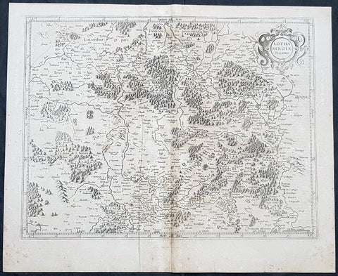
1628 Gerard Mercator Antique Map Lotharingia Region - Netherlands Germany France
- Title : Lotharingia Ducatus...Per Geradum Mercatorem Cum Privilegio
- Size: 21in x 17in (530mm x 430mm)
- Condition: (A) Very Good Condition
- Date : 1628
- Ref #: 26141
Description:
This original copper plate engraved antique map of the historical region of Lotharingia region of present-day Netherlands, Belgium, Luxembourg, North Rhine-Westphalia (Germany), Rhineland-Palatinate (Germany), Saarland (Germany), and Lorraine (France) by Gerard Mercator was published by Henricus Hondius in the early 1628 French edition of Gerard Mercators Atlas.
These maps, published in the early editions of Mercators atlas, are the original maps drawn and engraved by Gerald Mercator in the mid to late 16th century, published by his son Rumold as an atlas, after his death, in 1595. After two editions the plates were purchased by Jodocus Hondius in 1604 and continued to be published until the mid 1630\\\'s when the plates were re-engraved and updated by Jan Jansson and Henricus Hondius.
General Definitions:
Paper thickness and quality: - Heavy and stable
Paper color : - off white
Age of map color: -
Colors used: -
General color appearance: -
Paper size: - 21in x 17in (530mm x 430mm)
Plate size: - 20in x 15in (510mm x 380mm)
Margins: - Min 1/2in (12mm)
Imperfections:
Margins: - Age toning
Plate area: - Age toning
Verso: - Age toning
Lotharingia was a medieval successor kingdom of the Carolingian Empire, comprising the present-day Netherlands, Belgium, Luxembourg, North Rhine-Westphalia (Germany), Rhineland-Palatinate (Germany), Saarland (Germany), and Lorraine (France). It was named after King Lothair II who received this territory after the kingdom of Middle Francia of his father Lothair I was divided among his sons in 855.
Lotharingia was born out of the tripartite division in 855 of the kingdom of Middle Francia, which itself was formed after the threefold division of the Carolingian Empire by the Treaty of Verdun of 843. Conflict between East and West Francia over Lotharingia was based on the fact that these were the old Frankish homelands of Austrasia, so possession of them was of great prestige.
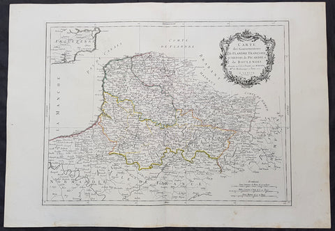
1777 F. Santini Antique Map Flanders Artois Hainaut Picardy Regions of Belgium
- Title : Carte Des Gouvernements de Flandre Francois d Artois de Picardie et du Boulenois...P Santini...1777
- Size: 30in x 21in (760mm x 535mm)
- Condition: (A+) Fine Condition
- Date : 1777
- Ref #: 50219
Description:
This large magnificent original copper-plate engraved antique map of Belgium and parts of Northern France made up of the provinces of Flanders, Artois, Hainaut, Picardy was engraved in 1777 - the date is engraved in the title cartouche - after Rigobert Bonne in 1771 and was published by Francois Santini (active 1776-84) in his 2 volume edition of Atlas Universal 1776-84.. (Ref: Tooley; M&B)
General Definitions:
Paper thickness and quality: - Heavy and stable
Paper color : - off white
Age of map color: - Original
Colors used: - Blue, pink, red, green, yellow
General color appearance: - Authentic
Paper size: - 30in x 21in (760mm x 535mm)
Plate size: - 23in x 18in (585mm x 460mm)
Margins: - Min 2in (50mm)
Imperfections:
Margins: - None
Plate area: - None
Verso: - None
Background:
Belgium officially the Kingdom of Belgium, is a country in Western Europe bordered by France, the Netherlands, Germany and Luxembourg.
Historically, Belgium was part of an area known as the Low Countries, a somewhat larger region than the current Benelux group of states that also included parts of northern France and western Germany. Its name is derived from the Latin word Belgica, after the Roman province of Gallia Belgica. From the end of the Middle Ages until the 17th century, the area of Belgium was a prosperous and cosmopolitan centre of commerce and culture. Between the 16th and early 19th centuries, Belgium served as the battleground between many European powers, earning the moniker the Battlefield of Europe, a reputation strengthened by both world wars. The country emerged in 1830 following the Belgian Revolution when it seceded from the Netherlands.
The Eighty Years War (1568–1648) divided the Low Countries into the northern United Provinces (Belgica Foederata in Latin, the Federated Netherlands) and the Southern Netherlands (Belgica Regia, the Royal Netherlands). The latter were ruled successively by the Spanish (Spanish Netherlands) and the Austrian Habsburgs (Austrian Netherlands) and comprised most of modern Belgium. This was the theatre of most Franco-Spanish and Franco-Austrian wars during the 17th and 18th centuries.
Following the campaigns of 1794 in the French Revolutionary Wars, the Low Countries—including territories that were never nominally under Habsburg rule, such as the Prince-Bishopric of Liège—were annexed by the French First Republic, ending Austrian rule in the region. The reunification of the Low Countries as the United Kingdom of the Netherlands occurred at the dissolution of the First French Empire in 1815, after the defeat of Napoleon.
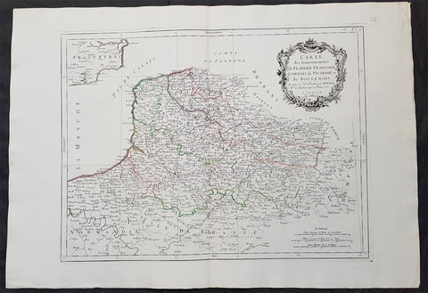
1777 F. Santini Antique Map Flanders Artois Hainaut Picardy Regions of Belgium
- Title : Carte Des Gouvernements de Flandre Francois d Artois de Picardie et du Boulenois...P Santini...1777
- Size: 30in x 21in (760mm x 535mm)
- Condition: (A+) Fine Condition
- Date : 1777
- Ref #: 50221
Description:
This large magnificent original copper-plate engraved antique map of Belgium and parts of Northern France made up of the provinces of Flanders, Artois, Hainaut, Picardy was engraved in 1777 - the date is engraved in the title cartouche - after Rigobert Bonne in 1771 and was published by Francois Santini (active 1776-84) in his 2 volume edition of Atlas Universal 1776-84.. (Ref: Tooley; M&B)
General Definitions:
Paper thickness and quality: - Heavy and stable
Paper color : - off white
Age of map color: - Original
Colors used: - Blue, pink, red, green, yellow
General color appearance: - Authentic
Paper size: - 30in x 21in (760mm x 535mm)
Plate size: - 23in x 18in (585mm x 460mm)
Margins: - Min 2in (50mm)
Imperfections:
Margins: - None
Plate area: - None
Verso: - None
Background:
Belgium officially the Kingdom of Belgium, is a country in Western Europe bordered by France, the Netherlands, Germany and Luxembourg.
Historically, Belgium was part of an area known as the Low Countries, a somewhat larger region than the current Benelux group of states that also included parts of northern France and western Germany. Its name is derived from the Latin word Belgica, after the Roman province of Gallia Belgica. From the end of the Middle Ages until the 17th century, the area of Belgium was a prosperous and cosmopolitan centre of commerce and culture. Between the 16th and early 19th centuries, Belgium served as the battleground between many European powers, earning the moniker the Battlefield of Europe, a reputation strengthened by both world wars. The country emerged in 1830 following the Belgian Revolution when it seceded from the Netherlands.
The Eighty Years War (1568–1648) divided the Low Countries into the northern United Provinces (Belgica Foederata in Latin, the Federated Netherlands) and the Southern Netherlands (Belgica Regia, the Royal Netherlands). The latter were ruled successively by the Spanish (Spanish Netherlands) and the Austrian Habsburgs (Austrian Netherlands) and comprised most of modern Belgium. This was the theatre of most Franco-Spanish and Franco-Austrian wars during the 17th and 18th centuries.
Following the campaigns of 1794 in the French Revolutionary Wars, the Low Countries—including territories that were never nominally under Habsburg rule, such as the Prince-Bishopric of Liège—were annexed by the French First Republic, ending Austrian rule in the region. The reunification of the Low Countries as the United Kingdom of the Netherlands occurred at the dissolution of the First French Empire in 1815, after the defeat of Napoleon.
1744 Georg Mattaus Seutter Antique Map of The Netherlands, XVII Provinces
- Title : XVII Provinciae.......a Matth. Seutteri...T C Lotter, Geogr.
- Ref #: 93395
- Size: 11in x 8 1/2in (280mm x 215mm)
- Date : 1744
- Condition: (A+) Fine Condition
Description:
This beautifully hand coloured original copper-plate engraved antique map of The Netherlands was engraved by Tobias Lotter and was published in the 1744 edition of GM Seutters Atlas Minor Prae cipua Orbis Terrarum Imperia Regna et Provincias...., Augsburg, Germany.
General Definitions:
Paper thickness and quality: - Heavy and stable
Paper color : - off white
Age of map color: - Original
Colors used: - Yellow, green, blue, pink
General color appearance: - Authentic
Paper size: - 11in x 8 1/2in (280mm x 215mm)
Plate size: - 10 1/2in x 8in (265mm x 205mm)
Margins: - Min 1/4in (5mm)
Imperfections:
Margins: - Light age toning
Plate area: - Light age toning
Verso: - None
Background:
Atlas Minor was a series of beautiful maps of all parts of the world. Georg Matthäus Seutter was one of the most and important of the German cartographers of the 18th century, being appointed as the Geographer to the Imperial Court. His son, Albrecht Carl, joined Matthäus and eventually inherited the business. The maps from Atlas Minor were drawn by the two Seutters and engraved by Tobias Conrad Lotte. These maps are highly detailed and engraved with a bold hand with equally strong original hand color in the body of the map as was the 18th century German style. The cartouches were left uncolored in order to emphasize the elaborately detailed illustrations for which German maps are especially prized. These are some of the most decorative and interesting maps of the eighteenth century.
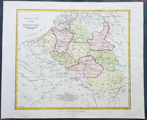
1808 Samuel Neele Large Antique Map of Belgium & Southern Netherlands
- Title : Belgium or the Netherlands divided into Departments
- Date : 1808
- Condition: (A+) Fine Condition
- Ref: 24329-1
- Size: 20in x 16in (510mm x 405mm)
Description:
This beautifully hand coloured original antique map of Belgium & the southern Netherlands was engraved by John Neele in 1808 - the date is engraved at the foot of the map - and published in the 1810 edition of The Modern Royal Atlas. (Ref: Tooley; M&B)
General Definitions:
Paper thickness and quality: - Heavy and stable
Paper color : - off white
Age of map color: - Original
Colors used: - Yellow, Green, pink
General color appearance: - Authentic
Paper size: - 20in x 16in (510mm x 405mm)
Plate size: - 16½in x 15in (420mm x 380mm)
Margins: - Min 1in (25mm)
Imperfections:
Margins: - Light creasing
Plate area: - Light creasing, light wear along bottom centerfold
Verso: - None
Background:
The name Belgium is derived from Gallia Belgica, a Roman province in the northernmost part of Gaul that before Roman invasion in 100 BC, was inhabited by the Belgae, a mix of Celtic and Germanic peoples. A gradual immigration by Germanic Frankish tribes during the 5th century brought the area under the rule of the Merovingian kings. A gradual shift of power during the 8th century led the kingdom of the Franks to evolve into the Carolingian Empire.
The Treaty of Verdun in 843 divided the region into Middle and West Francia and therefore into a set of more or less independent fiefdoms which, during the Middle Ages, were vassals either of the King of France or of the Holy Roman Emperor.
Many of these fiefdoms were united in the Burgundian Netherlands of the 14th and 15th centuries. Emperor Charles V extended the personal union of the Seventeen Provinces in the 1540s, making it far more than a personal union by the Pragmatic Sanction of 1549 and increased his influence over the Prince-Bishopric of Liège.
The Eighty Years\' War (1568–1648) divided the Low Countries into the northern United Provinces (Belgica Foederata in Latin, the Federated Netherlands) and the Southern Netherlands (Belgica Regia, the Royal Netherlands). The latter were ruled successively by the Spanish (Spanish Netherlands) and the Austrian Habsburgs (Austrian Netherlands) and comprised most of modern Belgium. This was the theatre of most Franco-Spanish and Franco-Austrian wars during the 17th and 18th centuries.
Following the campaigns of 1794 in the French Revolutionary Wars, the Low Countries—including territories that were never nominally under Habsburg rule, such as the Prince-Bishopric of Liège—were annexed by the French First Republic, ending Austrian rule in the region. The reunification of the Low Countries as the United Kingdom of the Netherlands occurred at the dissolution of the First French Empire in 1815, after the defeat of Napoleon.
Neele, Samuel John 1758–1824
Samuel John Neele was a cartographer, copper-plate engraver and printer with business in the Strand, London.
Also father of Henry Neele the English poet and literary scholar.