Europe (374)

1630-31 Hondius Antique World & Four Continent Maps America Africa Asia & Europe
- Title : Nova Totius Terrarum; America Noviter Delineata; Africae Nova Tabula; Asia recens summa; Europa Exactissime.
- Date : 1630-31
- Size: 22 1/2in x 20in (520mm x 505mm) ea
- Condition: (A & A+) Very Good & Fine Condition
- Ref: 43164; 43157; 43158; 43160; 43159
Description:
These 5 original, hand coloured copper plate engraved world and 4 continental maps, engraved by Henricus Hondius between 1630 and 1631 were published in the same 1639 edition of the Hondius/Mercator Atlas.
Henricus Hondius' World and Four Continent Maps are a series of highly detailed and beautifully illustrated and hand coloured maps that represent some of the finest examples of 17th-century cartography & artistry. The world map features ornate illustrations of ships, sea monsters, and mythological creatures, as well as depictions of important cities and landmarks around the globe. The four continent maps - Europe, Asia, Africa, and the Americas - are similarly detailed and feature intricate illustrations of people, animals, and mythological figures from each region. These maps are notable for their use of the Mercator projection and their accuracy in depicting the size and shape of the continents. Henricus Hondius' maps were highly valued during his lifetime and continue to be prized by collectors and scholars today for their historical significance and artistic beauty.
General Definitions:
Paper thickness and quality: - Heavy and stable
Paper color : - off white
Age of map color: - Original
Colors used: - Yellow, green, blue, pink
General color appearance: - Authentic
Paper size: - Please see background description below
Plate size: - Please see background description below
Margins: - Please see background description below
Imperfections:
Margins: - Please see background description below
Plate area: - Please see background description below
Verso: - Please see background description below
Background:
Nova Totius Terrarum: Dated 1630. Beautiful original hand colour, strong clean paper, original margin size. General Definitions:
Paper thickness and quality: - Heavy and stable
Paper color : - off white
Age of map color: - Original
Colors used: - Yellow, green, blue, pink, red
General color appearance: - Authentic
Paper size: - 22 1/2in x 20in (520mm x 505mm)
Plate size: - 21 1/2in x 15in (545mm x 380mm)
Margins: - Min 1in (25mm)
Imperfections:
Margins: - Old expert re-enforcement of margins front & verso. 4 small wormholes to margins
Plate area: - Creasing, slight separation of centerfold on bottom section of map
Verso: - Centerfold re-enforced
Overall condition: - VG
America Noviter Delineata: Dated 1631. Beautiful original hand colour, strong clean paper, original margins.
General Definitions:
Paper thickness and quality: - Heavy and stable
Paper color : - off white
Age of map color: - Original
Colors used: - Yellow, green, blue, pink, red
General color appearance: - Authentic
Paper size: - 22 1/2in x 20in (520mm x 505mm)
Plate size: - 19 3/4in x 15in (500mm x 380mm)
Margins: - Min 1in (25mm)
Imperfections:
Margins: - Light age toning
Plate area: - Light creasing along centerfold
Verso: - Bottom margin of centerfold re-enforced
Overall condition: - Fine
Africae Nova Tabula: Dated 1631. Beautiful original hand colour, strong clean paper, original margins.
General Definitions:
Paper thickness and quality: - Heavy and stable
Paper color : - off white
Age of map color: - Original
Colors used: - Yellow, green, blue, pink, red
General color appearance: - Authentic
Paper size: - 22 1/2in x 20in (520mm x 505mm)
Plate size: - 19 3/4in x 15in (500mm x 380mm)
Margins: - Min 1in (25mm)
Imperfections:
Margins: - Light age toning
Plate area: - Slight separation to bottom of centerfold
Verso: - Bottom margin of centerfold re-enforced
Overall condition: - Fine
Asia recens summa: Dated 1631. Beautiful original hand colour, strong clean paper, original margins.
General Definitions:
Paper thickness and quality: - Heavy and stable
Paper color : - off white
Age of map color: - Original
Colors used: - Yellow, green, blue, pink, red
General color appearance: - Authentic
Paper size: - 22 1/2in x 20in (520mm x 505mm)
Plate size: - 19 3/4in x 15in (500mm x 380mm)
Margins: - Min 1in (25mm)
Imperfections:
Margins: - Light age toning
Plate area: - Light creasing along centerfold
Verso: - Bottom centerfold & left corner margin re-enforced
Overall condition: - Fine
Europa Exactissime: Dated 1631. Beautiful original hand colour, strong clean paper, original margins.
General Definitions:
Paper thickness and quality: - Heavy and stable
Paper color : - off white
Age of map color: - Original
Colors used: - Yellow, green, blue, pink, red
General color appearance: - Authentic
Paper size: - 22 1/2in x 20in (520mm x 505mm)
Plate size: - 19 3/4in x 15in (500mm x 380mm)
Margins: - Min 1in (25mm)
Imperfections:
Margins: - Light age toning
Plate area: - Light creasing along centerfold
Verso: - Bottom margin re-enforced
Overall condition: - Fine
Please note all items auctioned are genuine, we do not sell reproductions. A Certificate of Authenticity (COA) can be issued on request.

1774 Malachy Postlethwayt Antique 2 Volume Atlas 7 Large Cont Maps North America
- Title : The Universal Dictionary of Trade and Commercewith large Improvements Adapting the Same to the Present State of British Affairs in America since the last Treaty of Peace made in the year 1763....MDCCLXXIV
- Ref #: 93529
-
Condition: (A+) Fine Condition
- Size: Large Folio
- Date : 1774
Description:
These very large, heavy leather backed original antique dictionary & atlas volumes of early Global Economic Commerce by Malachy Postlethwayt was published in 1774.
The Universal Dictionary of Trade and Commerce in 2 volumes is the 4th edition published in London by W. Strahan, J and F. Rivington, et al., in 1774. The first edition was published between 1751 & 1755. Titles in red and black with engraved vignettes, engraved allegorical frontispiece to volume 1 (offset onto title) and contain 24 engraved folding maps sheets that when assembled make 7 complete very large maps. Occasional minor spotting, contemporary diced calf, re-backed preserving original contrasting morocco labels, extremities repaired.
The seven maps once assembled, to the left, are as follows with titles, cartographers dates and dimensions;:
1. A Correct Map of Europe by Thomas Kitchin after D Anville, 80cm x 70cm, 1774
2. Africa Performed by the Sr D Anville Samuel Bolton after D Anville, 103cm x 94cm, 1774
3. A New and Correct Map of the Coast of Africa, so called Slave Coast Map, Richard Seale 48cm x 38cm, 1774
4. North America Performed under the Patronage of Louis Duke of Orleans Richard Seale after D Anville, 88cm x 86cm, 1774
5. South America Thomas Kitchin after D Anville, 124cm x 75cm, 1774
6. First Part of Asia RW Seale, after D Anville, 83cm x 77cm, 1755
7. Second Part of Asia R W Seale, after D Anville, 96cm x 70cm, 1755
General Definitions:
Paper thickness and quality: - Heavy and stable
Paper color : - off white
Age of map color: -
Colors used: -
General color appearance: -
Paper size: - Please see above
Plate size: - Please see above
Margins: - Please see above
Imperfections:
Margins: - Please see above
Plate area: - Please see above
Verso: - Please see above
Background:
Postlethwayts most noted work, The Universal Dictionary of Trade and Commerce, appeared after he had devoted twenty years to its preparation. The first edition was published in London in instalments between 1751 and 1755, and then in subsequent editions as a two-volume set in 1757, 1766, and 1774. This dictionary was a translation, with large additions and improvements, from Jacques Savary des Bruslons Dictionnaire universal de commerce (1723–1730). Postlethwayts dictionary was a huge storehouse of economic facts, laws and theory and his departures from the French version reflected his greater interest in political problems; his more intense economic nationalism; and his exuberant belief in the economic usefulness of experimental philosophy
In the 1757 edition of the Universal Dictionary, Postlethwayt outlined his vision for the establishment of a British mercantile college to benefit those who intended to work as merchants, or in gathering public revenue, or in merchandizing. He proposed that theoretical training for business should occur in formal academies and involve the study of mercantile computations, foreign exchanges and the intrinsic value of foreign coins, double-entry accounting, languages, geography, and public revenues and related laws. Postlethwayts ideas appear to have been influential in developing the statutes and procedures of the Portuguese School of Commerce, established in Lisbon in 1759.
It is documented that Thomas Jefferson gave a copy of this dictonary to his son in law, Thomas Mann Randolph, and as a prolific reader we must assumed also read by Jefferson.
Postlethwayt, Malachy 1707-1767
Malachy Postlethwayt was a prolific English writer and publicist on matters of mercantilist economics in the 1740s and 1750s. Little is known about his upbringing or formal education, although he is believed to be the brother of James Postlethwayt (d. 1761), a writer on finance and demography. Malachy Postlethwayt was elected a fellow of the Society of Antiquaries of London in 1734. His writings are claimed by Edgar Johnson to have exerted a good deal of influence on the trend of British economic thought.
Postlethwayt was alleged to be propagandist for the mercantilist endeavours of the Royal Africa Company, whose interests were well served by his publications The African Trade, the Great Pillar and Supporter of the British Plantation Trade in North America (1745) and The National and Private Advantages of the African Trade Considered (1746). These works supported a strategy of British commercial and manufacturing expansion through trade with Africa and the colonies, and promoted the importance of slavery for British commerce and industry.
Postlethwayts most noted work, The Universal Dictionary of Trade and Commerce, appeared after he had devoted twenty years to its preparation. The first edition was published in London in instalments between 1751 and 1755, and then in subsequent editions as a two-volume set in 1757, 1766, and 1774. This dictionary was a translation, with large additions and improvements, from Jacques Savary des Bruslons Dictionnaire universal de commerce (1723–1730). Postlethwayts dictionary was a huge storehouse of economic facts, laws and theory and his departures from the French version reflected his greater interest in political problems; his more intense economic nationalism; and his exuberant belief in the economic usefulness of experimental philosophy
In the 1757 edition of the Universal Dictionary, Postlethwayt outlined his vision for the establishment of a British mercantile college to benefit those who intended to work as merchants, or in gathering public revenue, or in merchandizing. He proposed that theoretical training for business should occur in formal academies and involve the study of mercantile computations, foreign exchanges and the intrinsic value of foreign coins, double-entry accounting, languages, geography, and public revenues and related laws. Postlethwayts ideas appear to have been influential in developing the statutes and procedures of the Portuguese School of Commerce, established in Lisbon in 1759.
Postlethwayts most important contribution to economic literature is regarded by many to be Britains Commercial Interest Explained and Improved (1757), in which he outlines his concept of physical commerce and the policies England should follow to attain commercial parity with foreign rivals.
Whether Postlethwayts writings were his original thoughts and words is a matter for conjecture. His Universal Dictionary included ideas taken from fifty other past or contemporary writers and that it had scattered throughout it practically all of Richard Cantillons Essai sur la nature du commerce en général (Essay on the Nature of Commerce in General, 1755). Although Postlethwayt was alleged widely to be a plagiarist, this accusation is believed to be exaggerated.
Postlethwayt died suddenly on September 13, 1767, and was buried in the Old Street Churchyard, Clerkenwell, in London.
Postlethwayt also published:
- The African Trade the great Pillar and Support of the British Plantation Trade in America, &c., 1745.
- The Natural and Private Advantages of the African Trade considered, &c., 1746.
- Britains Commercial Interest Explained, Vol. I of his Universal Dictionary of Trade and Commerce, 1747.[5]
- Considerations on the making of Bar Iron with Pitt or Sea Coal Fire, &c. In a Letter to a Member of the House of Commons, London, 1747.
- Considerations on the Revival of the Royal-British Assiento, between his Catholic Majesty and the … South-Sea Company. With an … attempt to unite the African-Trade to that of the South-Sea Company, by Act of Parliament, London, 1749.
- The Merchants Public Counting House, or New Mercantile Institution, &c., London, 1750.
- A Short State of the Progress of the French Trade and Navigation, &c., London, 1756.
- Great Britains True System. … To which is prefixed an Introduction relative to the Forming a New Plan of British Politicks with respect to our Foreign Affairs, &c., London, 1757.
- Britains Commercial Interest explained and improved, in a Series of Dissertations on several important Branches of her Trade and Police. … Also … the Advantages which would accrue … from an Union with Ireland, 2 vols., London, 1757; 2nd edit., With … a clear View of the State of our Plantations in America, &c., London, 1759.
- In Honour to the Administration. The importance of the African Expedition considered, &c., London, 1758
Please note all items auctioned are genuine, we do not sell reproductions. A Certificate of Authenticity (COA) can be issued on request.

1650 Jan Jansson & Nicolaas Blankaert 3 x Large Antique Maps Europe, Asia & Africa
- Title : Europa Antiqua cum finitimis; Asia antiqua cum finitimis; Africae Antiquae, et quarundam...
- Date : 1650
- Condition: (A+) Fine Condition
- Ref: 50489, 50490, 50492
- Size: 22 1/2in x 20in (565mm x 510mm) each
Description:
In 1650 Jan Jansson published three maps of the ancient world, Europe, Asia & Africa, after much considered and detailed work by the Leyden scholar of antiquities Nicolass Blanckaert 1624 - 1703, Latin Nicolaus Blancardus. These three highly detailed maps were only published in limited release and so are incredibly rare, especially as a set.
Nicolaas Blanckaert was a respected expert on the ancient world specialising on the Roman World and Alexander the Great. Three incredibly rare maps in exceptional condition.
General Definitions:
Paper thickness and quality: - Heavy and stable
Paper color : - off white
Age of map color: -
Colors used: -
General color appearance: -
Paper size: - 22 1/2in x 20in (565mm x 510mm) each
Plate size: - 20 1/2in x 15in (510mm x 380mm); 22in x 18 1/2in (560mm x 470mm); 21in x 15in (535mm x 380mm)
Margins: - Min 1/2in (12mm)
Imperfections:
Margins: - None
Plate area: - None
Verso: - None
Background:
Alexander III of Macedon 356 – 323 BC, commonly known as Alexander the Great, was a king (basileus) of the ancient Greek kingdom of Macedon and a member of the Argead dynasty. He was born in Pella in 356 BC and succeeded his father Philip II to the throne at the age of 20. He spent most of his ruling years on an unprecedented military campaign through Asia and northeast Africa, and by the age of thirty, he had created one of the largest empires of the ancient world, stretching from Greece to northwestern India. He was undefeated in battle and is widely considered one of historys most successful military commanders.
During his youth, Alexander was tutored by Aristotle until age 16. After Philips assassination in 336 BC, he succeeded his father to the throne and inherited a strong kingdom and an experienced army. Alexander was awarded the generalship of Greece and used this authority to launch his fathers pan-Hellenic project to lead the Greeks in the conquest of Persia. In 334 BC, he invaded the Achaemenid Empire (Persian Empire) and began a series of campaigns that lasted 10 years. Following the conquest of Anatolia, Alexander broke the power of Persia in a series of decisive battles, most notably the battles of Issus and Gaugamela. He subsequently overthrew Persian King Darius III and conquered the Achaemenid Empire in its entirety. At that point, his empire stretched from the Adriatic Sea to the Beas River.
Alexander endeavoured to reach the ends of the world and the Great Outer Sea and invaded India in 326 BC, winning an important victory over the Pauravas at the Battle of the Hydaspes. He eventually turned back at the demand of his homesick troops, dying in Babylon in 323 BC, the city that he planned to establish as his capital, without executing a series of planned campaigns that would have begun with an invasion of Arabia. In the years following his death, a series of civil wars tore his empire apart, resulting in the establishment of several states ruled by the Diadochi, Alexanders surviving generals and heirs.
Alexanders legacy includes the cultural diffusion and syncretism which his conquests engendered, such as Greco-Buddhism. He founded some twenty cities that bore his name, most notably Alexandria in Egypt. Alexanders settlement of Greek colonists and the resulting spread of Greek culture in the east resulted in a new Hellenistic civilization, aspects of which were still evident in the traditions of the Byzantine Empire in the mid-15th century AD and the presence of Greek speakers in central and far eastern Anatolia until the Greek genocide of the 1920s. Alexander became legendary as a classical hero in the mould of Achilles, and he features prominently in the history and mythic traditions of both Greek and non-Greek cultures. He was undefeated in battle and became the measure against which military leaders compared themselves. Military academies throughout the world still teach his tactics. He is often ranked among the most influential people in history.
The Roman Empire was the post-Republican period of ancient Rome. As a polity it included large territorial holdings around the Mediterranean Sea in Europe, North Africa and West Asia ruled by emperors. From the accession of Caesar Augustus to the military anarchy of the third century, it was a principate with Italy as metropole of the provinces and its city of Rome as sole capital (27 BC – 286 AD). Although fragmented briefly during the military crisis, the empire was forcibly reassembled, then ruled by multiple emperors who shared rule over the Western Roman Empire (based in Milan and later in Ravenna) and over the Eastern Roman Empire (based in Nicomedia and later in Constantinople). Rome remained the nominal capital of both parts until 476 AD, when it sent the imperial insignia to Constantinople (Byzantium - Ancient Greek: Βυζάντιον, Byzántion) following the capture of Ravenna by the barbarians of Odoacer and the subsequent deposition of Romulus Augustus. The fall of the Western Roman Empire to Germanic kings, along with the hellenization of the Eastern Roman Empire into the Byzantine Empire, conventionally marks the end of Ancient Rome and the beginning of the Middle Ages.
The predecessor state of the Roman Empire, the Roman Republic (which had replaced Romes monarchy in the 6th century BC) became severely destabilized in a series of civil wars and political conflicts. In the mid-1st century BC Julius Caesar was appointed as perpetual dictator and then assassinated in 44 BC. Civil wars and proscriptions continued, culminating in the victory of Octavian, Caesars adopted son, over Mark Antony and Cleopatra at the Battle of Actium in 31 BC. The following year Octavian conquered Ptolemaic Egypt, ending the Hellenistic period that had begun with the conquests of Alexander the Great of Macedon in the 4th century BC. Octavians power then became unassailable, and in 27 BC the Roman Senate formally granted him overarching power and the new title Augustus, effectively making him the first Roman emperor.
The first two centuries of the Empire saw a period of unprecedented stability and prosperity known as the Pax Romana (Roman Peace). Rome reached its greatest territorial expanse during the reign of Trajan (98–117 AD). A period of increasing trouble and decline began with the reign of Commodus (177-192). In the 3rd century the Empire underwent a crisis that threatened its existence, as the Gallic Empire and Palmyrene Empire broke away from the Roman state, and a series of short-lived emperors, often from the legions, led the empire. The empire was reunified under Aurelian (r. 270–275). In an effort to stabilize the Empire, Diocletian set up two different imperial courts in the Greek East and Latin West in 286. Christians rose to positions of power in the 4th century following the Edict of Milan of 313. Shortly after, the Migration Period, involving large invasions by Germanic peoples and by the Huns of Attila, led to the decline of the Western Roman Empire. With the fall of Ravenna to the Germanic Herulians and the deposition of Romulus Augustulus in 476 AD by Odoacer, the Western Roman Empire finally collapsed – the (Eastern Roman) Emperor Zeno formally abolished it in 480 AD. Nonetheless, some states in the territories of the former Western Roman Empire would later claim to have inherited the supreme power of the emperors of Rome, most notably the Holy Roman Empire. The Eastern Roman Empire, identified by modern historians under the name of the Byzantine Empire, survived for another millennium until the Empires last remains collapsed when Constantinople fell to the Ottoman Turks of Sultan Mehmed II in 1453.
Due to the Roman Empires vast extent and long endurance, the institutions and culture of Rome had a profound and lasting influence on the development of language, religion, art, architecture, philosophy, law, and forms of government in the territory it governed, and far beyond. The Latin language of the Romans evolved into the Romance languages of the medieval and modern world, while Medieval Greek became the language of the Eastern Roman Empire. The Empires adoption of Christianity led to the formation of medieval Christendom. Greek and Roman art had a profound impact on the Italian Renaissance. Romes architectural tradition served as the basis for Romanesque, Renaissance and Neoclassical architecture, and also had a strong influence on Islamic architecture. The corpus of Roman law has its descendants in many legal systems of the world today, such as the Napoleonic Code, while Romes republican institutions have left an enduring legacy, influencing the Italian city-states republics of the Medieval period, as well as the early United States and other modern democratic republics.

1815 Horsburgh Large Antique Map of St Helena Island HMS Northumberland Napoleon
- Title : A Survey of The Bank of Soundings and Dangers around The Island St. Helena by Mr. George Thoms. on His Majesty Ship Northumberland Rear Admiral Sir George Cockburn, in 1815
- Date : 1815
- Condition: (A+) Fine Condition
- Ref: 35002
- Size: 27in x 26in (685mm x 660mm)
Description:
This large extremely rare original antique map of St Helena Island is special. Special not just because of its rarity but also because the survey of the Island to construct this map, were undertaken by George Thomas onboard HMS Northumberland in 1815.
The Northumberland, under the command of Rear Admiral Sir George Cockburn, was responsible for transporting Napoleon to the Island after his defeat at the battle of Waterloo. And so the surveys would have been carried out by Thomas, after delivering Napoleon to the Island and would have been used by the Royal Navy as intelligence in case of a rescue or kidnap attempt on Napoleon.
I have been able to locate only one other copy of the map in the Bibliothèque nationale de France.
The map has extensive depth soundings as well as coastal navigation points with text on both the Barn & Sperry Ledge and remarks on sunken rocks off Mundens Point and James Town.
The map was published by John Horsburgh Hydrographer to the East India Company on January 1st 1817.
Admiral of the Fleet Sir George Cockburn, 10th Baronet (22 April 1772 – 19 August 1853) was a Royal Navy officer. As a captain he was present at the battle of Cape St Vincent in February 1797 during the French Revolutionary Wars and commanded the naval support at the reduction of Martinique in February 1809 during the Napoleonic Wars. He also directed the capture and burning of Washington on 24 August 1814 as an advisor to Major General Robert Ross during the War of 1812. He went on to be First Naval Lord and in that capacity sought to improve the standards of gunnery in the fleet, forming a gunnery school at Portsmouth; later he ensured that the Navy had latest steam and screw technology and put emphasis of the ability to manage seamen without the need to resort to physical punishment.
In August 1815 Cockburn was given the job of conveying Napoleon Bonaparte in the third-rate HMS Northumberland to Saint Helena: Cockburn remained there for some months as governor of the island and Commander-in-Chief of the Cape of Good Hope Station. He was advanced to Knight Grand Cross of the Order of the Bath on 20 February 1818, and having been promoted to vice-admiral on 12 August 1819, he was elected a Fellow of the Royal Society on 21 December 1820
HMS Northumberland was a 74-gun third rate ship of the line of the Royal Navy, built at the yards of Barnard, Deptford and launched on 2 February 1798.
Northumberland participated in the Battle of San Domingo, where she was damaged, and suffered 21 killed and 74 wounded, the highest casualties of any British ship in the battle.
On November 22, 1810, Northumberland, while in the company of HMS Armada, a 74-gun third rate, captured the 14-gun French privateerketch La Glaneuse.
She received a measure of fame when she transported Napoleon I into captivity on the Island of Saint Helena. Napoleon had surrendered to Captain Frederick Maitland of HMS Bellerophon, on 15 July 1815 and was then transported to Plymouth. Napoleon was transferred from the Bellerophon to the Northumberland for his final voyage to St. Helena because concerns were expressed about the suitability of the ageing ship. HMS Northumberland was therefore selected instead. (Ref: M&B; Tooley)
General Description:
Paper thickness and quality: - Heavy & stable
Paper color: - White
Age of map color: -
Colors used: -
General color appearance: -
Paper size: - 27in x 26in (685mm x 660mm)
Plate size: - 25 1/2in x 25in (650mm x 635mm)
Margins: - Min 1/2in (12mm)
Imperfections:
Margins: - None
Plate area: - None
Verso: - None

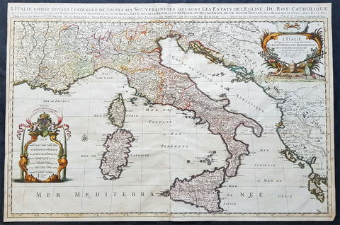
1692 Alex Jaillot Large Antique Map of Italy, Sicily - Gold Imperial Highlights
Antique Map
- Title : L' Italie Divisee Suivant Les l'estendue de tous Les Estats, Royaumes, Republiques, Duches, Principates...1692.
- Ref #: 35631
- Condition: (A+) Fine Condition
- Size: 37 1/2in x 24 3/4in (940mm x 630mm)
- Date: 1691
- Price: $1599.00US
Description:
This original, beautifully hand coloured (with gold highlights) antique, very large map of Italy was engraved in 1692 - dated in Cartouche - and was published by Hubert Jaillot in his monumental Atlas Nouveau.
This map is beautifully hand coloured with gold highlights along country borders and the cartouches indicating it was once part of an Imperial Atlas.
The Imperial atlases were hand coloured using gold highlights and other rare colours which at the time was extremely expensive and available at the time only to royalty and the very rich.
General Definitions:
Paper thickness and quality: - Heavy and stable
Paper color : - Off white
Age of map color: - Original
Colors used: - Yellow, green, blue, pink, blue, gold
General color appearance: - Authentic
Paper size: - 37 1/2in x 24 3/4in (940mm x 630mm)
Plate size: - 35 1/2in x 23in (900mm x 590mm)
Margins: - Min 1in (25mm)
Imperfections:
Margins: - None
Plate area: - Light offsetting
Verso: - Age toning to verso
Background:
Since classical times the countries bordering the enclosed waters of the Mediterranean had been well versed in the use of maps and sea charts and in Italy, more than anywhere else, the traditional knowledge was kept alive during the many hundreds of years following the collapse of the Roman Empire. By the thirteenth and fourteenth centuries the seamen of Venice, Genoa and Amalfi traded to far countries, from the Black Sea ports and the coasts of Palestine and Egypt in the East to Flanders and the southern coasts of England and Ireland in the West, their voyages guided by Portolan charts and the use of the newly invented compass. For a time Italian supremacy in cartography passed to Aragon and the Catalan map makers based on Majorca, but by the year 1400 the power and wealth of the city states of Venice, Genoa, Florence and Milan surpassed any in Europe. Florence, especially, under the rule of the Medici family, became not only a great trading and financial centre but also the focal point of the rediscovery of the arts and learning of the ancient world. In this milieu a number of manuscript world maps were produced, of which one by Fra Mauro (c. 1459) is the most notable, but the event of the greatest importance in the history of cartography occurred in the year 1400 when a Florentine, Palla Strozzi, brought from Constantinople a Greek manuscript copy of Claudius Ptolemy's Geographia, which, 1,250 years after its compilation, came as a revelation to scholars in Western Europe. In the following fifty years or so manuscript copies, translated into Latin and other languages, became available in limited numbers but the invention of movable-type printing transformed the scene: the first copy without maps being printed in 1475 followed by many with copper-engraved maps, at Bologna in 1477, Rome 1478, 1490, 1507 and 1508, and Florence 1482.
About the year 1485 the first book of sea charts, compiled by Bartolommeo dalli Sonetti, was printed in Venice and in the first part of the sixteenth century a number of world maps were published, among them one compiled in 1506 by Giovanni Contarini, engraved by Francesco Rosselli, which was the first printed map to show the discoveries in the New World. In the following years there were many attractive and unusual maps of Islands (Isolano) by Bordone, Camocio and Porcacchi, but more important was the work of Giacomo (Jacopo) Gastaldi, a native of Piedmont who started life as an engineer in the service of the Venetian Republic before turning to cartography as a profession. His maps, produced in great variety and quantity, were beautifully drawn copperplate engravings and his style and techniques were widely copied by his contemporaries. From about 1550 to 1580 many of Gastaldi's maps appeared in the collections of maps known as Lafreri 'atlases', a term applied to groups of maps by different cartographers brought together in one binding. As the contents of such collections varied considerably they were no doubt assembled at the special request of wealthy patrons and are now very rare indeed.
About this time, for a variety of historical and commercial reasons, Italy's position as the leading trading and financial nation rapidly declined and with it her superiority in cartography was lost to the vigorous new states in the Low Countries. That is not to say, of course, that Italian skills as map makers were lost entirely for it was not until 1620 that the first printed maps of Italy by an Italian, Giovanni Magini, appeared, and much later in the century there were fine maps by Giacomo de Rossi and Vincenzo Coronelli, the latter leading a revival of interest in cartography at the end of the century. Coronelli was also famous for the construction of magnificent large-size globes and for the foundation in Venice in 1680 of the first geographical society.
In the eighteenth century the best-known names are Antonio Zatta, Rizzi-Zannoni and Giovanni Cassini.
We ought to mention the work of Baptista Boazio who drew a series of maps in A Summarie and True Discourse of Sir Francis Drake's West Indian Voyage, published in 1588-89, and who is especially noted for a very fine map of Ireland printed in 1599 which was incorporated in the later editions of the Ortelius atlases. It is perhaps appropriate also to refer to two English map makers who spent many years in exile in Italy: the first, George Lily, famous for the splendid map of the British Isles issued in Rome in 1546, and the second, Robert Dudley, who exactly one hundred years later was responsible for the finest sea atlas of the day, Dell' Arcano del Mare, published in Florence. Both of these are described in greater detail elsewhere in this handbook. (Ref: Tooley, Koeman)

1691 Alex Jaillot Large Antique Map of South America, Gold Imperial Highlights
Antique Map
- Title : Amerique Meridionale Divisee en ses Principales Parties...1691
- Ref #: 35630
- Condition: (A+) Fine Condition
- Size: 37 1/2in x 24 3/4in (940mm x 630mm)
- Date: 1691
Description:
This original beautifully hand coloured (with gold highlights) antique very large map of South America was engraved in 1691 - dated in Cartouche - and was published by Hubert Jaillot in his monumental Atlas Nouveau.
This map is beautifully hand coloured with gold highlights along country borders and the cartouches indicating it was once part of an Imperial Atlas.
The Imperial atlases were hand coloured using gold highlights and other rare colours which at the time was extremely expensive and available at the time only to royalty and the very rich.
General Definitions:
Paper thickness and quality: - Heavy and stable
Paper color : - Off white
Age of map color: - Original
Colors used: - Yellow, green, blue, pink, blue, gold
General color appearance: - Authentic
Paper size: - 37 1/2in x 24 3/4in (940mm x 630mm)
Plate size: - 35 1/2in x 23in (900mm x 590mm)
Margins: - Min 1in (25mm)
Imperfections:
Margins: - Age toning along margins
Plate area: - Crease along centerfold
Verso: - None
Background:
The map include lines of latitude and longitude, some topographical details, location of settlements, rivers, and lakes (including the lakes Parime, thought to be where the fabulous El Dorado was located) as well as the boundaries of the possessions of the European claimants to South America.
Extremely decorative cartouche with dedication to Le Dauphin, and his coat of arms in top.
After Nicolas Sanson, Hubert Jaillot and Pierre Duval were the most important French cartographers of the seventeenth & eighteenth centuries. Jaillot, originally a sculptor, became interested in geography after his marriage to the daughter of Nicolas Berey (1606-65), a famous map colourist, and went into partnership in Paris with Sanson's sons. There, from about 1669, he undertook the re-engraving, enlarging and re-publishing of the Sanson maps in sheet form and in atlases, sparing no effort to fill the gap in the map trade left by the destruction of Blaeu's printing establishment in Amsterdam in 1672. Many of his maps were printed in Amsterdam (by Pierre Mortier) as well as in Paris. One of his most important works was a magnificent sea atlas, Le Neptune François, published in 1693 and compiled in co-operation with J D Cassini. This was re-published shortly afterwards by Pierre Mortier in Amsterdam with French, Dutch and English texts, the charts having been re-engraved. Eventually, after half a century, most of the plates were used again as the basis for a revised issue published by J N Bellin in 1753.(Ref: Tooley; M&B)

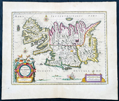
1647 Joan Blaeu Antique Map of Iceland - Beautiful Original Hand Colouring
- Title :Tabula Islandia Auctore Georgio Carolo Flandro
- Ref #: 17042
- Size: 23 1/2in x 19in (590mm x 485mm)
- Date : 1647
- Condition: (A+) Fine Condition
Description:
This is possibly one the best original hand coloured maps of Iceland by Blaeu, we have had the pleasure to offer.
This map, by Willem Blaeu, was engraved by Jodocus Hondius after Joris Carolus, and was published by Willem Blaeus son, Joan, in the 1647 German edition of Atlas Nouvs
General Definitions:
Paper thickness and quality: - Heavy and stable
Paper color : - off white
Age of map color: - Original
Colors used: - Yellow, green, blue, pink
General color appearance: - Authentic
Paper size: - 23 1/2in x 19in (590mm x 485mm)
Plate size: - 20in x 15 1/4in (510mm x 395mm)
Margins: - Min 1in (25mm)
Imperfections:
Margins: - Light age toning in left margin
Plate area: - Small stain top right of map
Verso: - None
Background:
This map of Iceland is perhaps the most familiar of all the outlines of the island ever published. The author is stated to be one Joris Carolus, a Dutch navigator from Enkhuizen, whose map was first engraved and prepared by Jodocus Hondius the younger in 1628, whose plates were bought by Willem Blaeu in 1629. Iceland bears the imprint of Willem Blaeu who issued it in his Appendix of 1630.
The Carolus map was copied by virtually all mapmakers throughout the rest of the 17th century and well into the 18th. Some of the information is derived from a map made famous by the Flemish cartographer Abraham Ortelius, the Islandia of Gudhbrandur Thorlaksson (1541 - 1627) Bishop of Holar, who had studied mathematics and astronomy as well as theology, while other information, such as place names, is derived from Gerard Mercator's map of 1595.
Willem Blaeu reprinted the map without change in his subsequent atlas editions, as did Joan after him, including the great atlas of 1662. In the southern southern part is shown the lively impression of Hekla in full eruption, described as mons perpetuo ardens while immediately to the west, the Bishopric of Skalholt is marked. To the south a note by Eiapialla hokel (Eyjafjallajokull) states that here may be found falcones albi or white falcons, presumably referring to the gyr falcon.
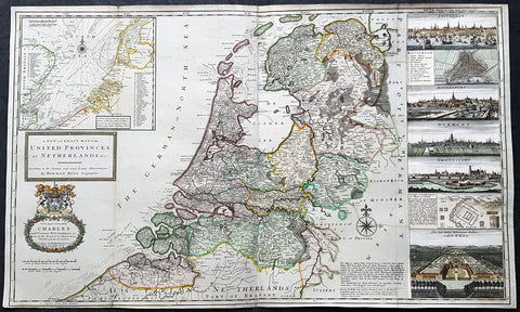
1720 Herman Moll Large Antique Map of The Netherlands - 7 x Town Plans Amsterdam
- Title : A New and Exact Map of the United Provinces, or Netherlands &c. According to the Newest and Most Exact Observations by Herman Moll Geographer
- Size: 41in x 25in (1.04m x 635mm)
- Condition: (A+) Fine Condition
- Date : 1720
- Ref #: 93007
Description:
This very large beautifully hand coloured original copper-plate engraved antique map of The Netherlands by Herman Moll was published in 1720 in the atlas The World Described, or a New and Correct Sett of Maps by John Bowles, Thomas Bowles, Philip Overton & John King of London.
In the 18th century many large-scale maps were published by the likes of John Senex and Herman Moll, this trend continued until the end of private mapping in the early 19th century when it was replaced by Ordnance Survey maps.
General Definitions:
Paper thickness and quality: - Heavy and stable
Paper color : - off white
Age of map color: - Original & later
Colors used: - Blue, pink, red, green, yellow
General color appearance: - Authentic
Paper size: - 41in x 25in (1.02m x 635mm)
Plate size: - 39 1/4in x 24 1/2in (1.00m x 610mm)
Margins: - Min 1/4in (5mm)
Imperfections:
Margins: - Light age toning
Plate area: - Folds as issyed
Verso: - Backed onto contemporary paper
Background:
An attractive, large scale map of The Netherlands or the United Provinces by the highly regarded cartographer and engraver Herman Moll. on the right-hand side views of Amsterdam, Rotterdam, Middelburg, Utrecht, Groningen, Het Loo Palace and a plan of the ancient Roman Castle at the mouth of the Rhine river Arx Britannica (Huis Britten, Brittenberg). The upper left corner of the map has an inset map of the coasts, sands and banks of the North Sea, the stretch of water that lies between England and The Netherlands. Moll dedicates his map to ‘The Right Hon Charles Lord Viscount of Townsend &c one of his Majesty’s Principal Secretaries of State’
This magnificent map was printed by John Bowles of Cornhill, London and published in Moll’s 1719 New and Complete Atlas, but it may also have been separately issued earlier. Moll came to London probably from Bremen around 1678 and by 1688 he had his own shop in Vanley\'s Court in London\'s Blackfriars, between 1691 and 1710 at the corner of Spring Gardens and Charing Cross, when he moved to Beech Street where he remained until his death. In 1701 he published his first work A System of Geography. He was publishing atlases and separately issued maps, and from 1710 was also known as a maker of pocket globes. (Ref: Tooley, Koeman, M&B)
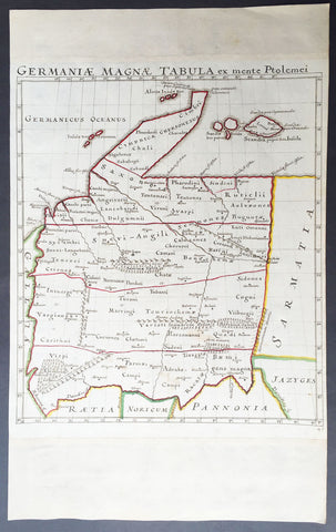
1650 Original Antique Hand Drawn Manuscript Map of Ptolemaic Germany - Unique
- Title : Germaniae Magnae Tabula ex mente Ptolemei
- Ref #: 50525
- Size: 19in x 12in (485mm x 305mm)
- Date : 1650
- Condition: (A+) Fine Condition
Description:
This is a unique and rare opportunity to acquire a hand drawn hand coloured manuscript Ptolemaic map of Germany.
The map was drawn from Ptolemy's map of Germany and is drawn on heavy cable laid paper with a Bunch of Grapes watermark, which denotes paper made in France in 1616. This does not necessarily mean the map was drawn in 1616 as paper was held for years sometimes before being used. But I would surmise from the colours, faded ink and age of the paper that the drawing was done sometime by the mid 17th century.
The map was once part of an atlas containing a range of 17th & 18th century maps with the margins being extended top and bottom to fit into the atlas.
Background of Ptolemy's Geographia: The first published edition of Ptolemy's ‘Geographia’ with maps, engraved by Taddeo Crivelli, was issued in Bologna in 1477. Unusually, this edition contained 26 maps, with one of the Asia maps divided up among three neighbouring sheets. With the exception of Palestine, these are the first regional maps of any of these various countries.
Unfortunately for the undertakers, this atlas seems not to have been a commercial success, and today only twenty-six examples of the atlas are recorded, with all but one in institutional libraries.
One explanation of the failure is that the publishers do not seem to have been fully mastered the intricacies and problems of engraving, and printing from, copper-plates, an art, which, after all, was very new and experimental. These problems were more successfully addressed by a German printer, Conrad Sweynheym, who was working on an edition of Ptolemy in Rome in the same period. Unfortunately, he did not live to see the volume appear, but his successor, Arnold Buckinck, saw the atlas through the press, in 1478.
The Rome Ptolemy contained 27 maps, with the same geographical coverage as the 1477 Ptolemy. Of the engraved editions of Ptolemy’s ‘Cosmographia’ the maps in the Rome edition are the finest fifteenth century examples, and second only to Mercator’s maps, from his 1578 edition. One explanation for this was the use of individual punches to stamp letters onto the printing plates, rather than engraving them. This allowed much greater uniformity than lettering-engravers were able to achieve, and gives a very pleasing overall effect. The atlas proved popular, and three successive editions (to 1508) followed, although only about forty examples of the first edition are recorded today.
Claudius Ptolemy(90 A.D.-168 A.D.) was a celebrated astronomer, mathematician, and geographer who lived in Alexandria in the 2nd century AD. Although his thinking influenced contemporary Arab geographers, little was known of his work in the West until manuscripts from Constantinople reached Italy in about 1400. These manuscripts were written in Greek and contained the names of every city, island, mountain and river known to the many travellers interviewed by Ptolemy. In addition, the latitude and longitude of each of the resulting eight thousand locations were also recorded. They were translated into Latin by 1401 and appeared in print by 1475. The earliest Byzantine manuscript maps, drawn by analysing the Ptolemy figures, date from the twelfth century. A number of hand-drawn copies were made in Italy throughout the early fifteenth century to accompany Ptolemy's text.
Ptolemy stressed the importance of accurate observations in order to calculate latitude and longitude, and laid down the principals of systematic cartography that remain to this day. Obviously there are many errors in Ptolemy's maps, due to the limited extent of basic geographic information at that time and the lack of a method of determining accurate longitudes. Judged by modern standards, the basic shortcoming of the Ptolemy world map is the small area it portrays. The Mediterranean is fairly well depicted, but is greatly exaggerated in length (Longitudinally). The effect of this, combined with Ptolemy's disregard for Eratosthenes' extremely accurate estimate of the earth's circumference (c. 200 B.C.) and the use of a Posidonius' much smaller flawed estimate (c.50 B.C.) implied a much shorter distance across that part of the unknown earth's surface not drawn on the map. Columbus and his contemporaries based their exploratory ventures on Ptolemy's calculations and, like him, had no idea of the vast New World to the west, interposed between Europe and Asia.
Work on the first “printed” atlas from the text of Ptolemy was started in 1473 and finally published in 1478. A crude copy of this atlas was produced and published by some dissident workers in 1477 in order to be ‘first’.However, the plates for the 1478 were done prior to the pirated issue and thus the 1478 atlas holds the title of the first Atlas of the world. There are very few surviving examples of this atlas and individual maps. (Ref: Stevenson; Tooley; M&B)
General Description:
Paper thickness and quality: - Heavy and stable
Paper color: - off white
Age of map color: - Original
Colors used: - Yellow, green, red.
General color appearance: - Authentic
Paper size: - 19in x 12in (485mm x 305mm)
Map size: - 13in x 11 1/2in (330mm x 295mm)
Margins: - Min 1/4in (6mm)
Imperfections:
Margins: - Top and bottom margin extended outside of image
Plate area: - None
Verso: - Light soiling

1574 Abraham Ortelius Antique Map of Spain & Portugal - Regni Hispaniae
- Title : Regni Hispaniae Post Omnium Editiones Locvplessima Descriptio
- Ref #: 82078
- Size: 21 1/2in x 16in (545mm x 405mm)
- Date : 1574
- Condition: (A) Very Good Condition
Description:
This beautifully hand coloured original antique map of Spain & Portugal, 1st edition - based on the cartographic work of Charles de L Escluse - was published by Abraham Ortelius in the 1574 Latin edition of Theatrum Orbis Terrarum.
Ortelius published a total of 8175 of this map between 1570 to 1641 in 4 States. According to Marcel Van den Broecke there are estimated to be only 155 loose copies in circulation today.
General Definitions:
Paper thickness and quality: - Heavy and stable
Paper color : - off white
Age of map color: - Early
Colors used: - Yellow, green, blue, pink
General color appearance: - Authentic
Paper size: - 21 1/2in x 16in (545mm x 405mm)
Plate size: - 19 1/2in x 15in (495mm x 380mm)
Margins: - Min 1in (25mm)
Imperfections:
Margins: - Small repair to bottom margin
Plate area: - Small repair adjacent to bottom centerfold, no loss
Verso: - Centerfold re-enforced on verso
Background:
Many of the original charts and maps drawn by the first Portuguese and Spanish navigators have survived for the very good reason that, on completion of their voyages, pilots were obliged to hand over their manuscript notes to the Casa da India (founded 1504) in Lisbon or to the equivalent Casa de Contrataci6n de las Indias (founded 1504) in Seville. The clear intention was to maintain secrecy over new discoveries and control over the distribution of cartographic material, not always successfully, as it happened; pilots and navigators seem to have changed allegiance with impunity and, in consequence, many of the earliest and most informative charts were compiled as far away as Genoa, Venice, Florence and Ancona, presumably from sources outside the Portuguese and Spanish \'Casas\'.It is apparent that few manuscripts reached the printing stage and, indeed, are so rare that any study of them must be regarded as a specialist subject. (Ref Tooley M&B)
1692 Alexis Jaillot Large Original Antique Map of Italy, Sardinia & Corsica
- Title : L' Italie Divisee Suivant Les l'estendue de tous Les Estats, Royaumes, Republiques, Duches, Principates...1692.
- Size: 35 1/2in x 23 3/4in (900mm x 600mm)
- Condition: (A+) Fine Condition
- Date : 1692
- Ref #: 35008
Description:
This very large, beautifully hand coloured original antique map of Italy by Alexis Hubert Jaillot - after Nicolas Sanson - was engraved in 1692 - the date is engraved in the title cartouche.
Beautifully presented Jaillot map, fantastic colour, clean and heavy paper and a deep clear impression, signifying an early pressing.
General Definitions:
Paper thickness and quality: - Heavy and stable
Paper color : - off white
Age of map color: - Original
Colors used: - Yellow, green, blue, pink
General color appearance: - Authentic
Paper size: - 35 1/2in x 23 3/4in (900mm x 600mm)
Plate size: - 35in x 23in (890mm x 585mm)
Margins: - Min 1in (25mm)
Imperfections:
Margins: - Very small repairs to margin edges, no loss
Plate area: - None
Verso: - None
Background:
Since classical times the countries bordering the enclosed waters of the Mediterranean had been well versed in the use of maps and sea charts and in Italy, more than anywhere else, the traditional knowledge was kept alive during the many hundreds of years following the collapse of the Roman Empire. By the thirteenth and fourteenth centuries the seamen of Venice, Genoa and Amalfi traded to far countries, from the Black Sea ports and the coasts of Palestine and Egypt in the East to Flanders and the southern coasts of England and Ireland in the West, their voyages guided by Portolan charts and the use of the newly invented compass. For a time Italian supremacy in cartography passed to Aragon and the Catalan map makers based on Majorca, but by the year 1400 the power and wealth of the city states of Venice, Genoa, Florence and Milan surpassed any in Europe. Florence, especially, under the rule of the Medici family, became not only a great trading and financial centre but also the focal point of the rediscovery of the arts and learning of the ancient world. In this milieu a number of manuscript world maps were produced, of which one by Fra Mauro (c. 1459) is the most notable, but the event of the greatest importance in the history of cartography occurred in the year 1400 when a Florentine, Palla Strozzi, brought from Constantinople a Greek manuscript copy of Claudius Ptolemy's Geographia, which, 1,250 years after its compilation, came as a revelation to scholars in Western Europe. In the following fifty years or so manuscript copies, translated into Latin and other languages, became available in limited numbers but the invention of movable-type printing transformed the scene: the first copy without maps being printed in 1475 followed by many with copper-engraved maps, at Bologna in 1477, Rome 1478, 1490, 1507 and 1508, and Florence 1482.
About the year 1485 the first book of sea charts, compiled by Bartolommeo dalli Sonetti, was printed in Venice and in the first part of the sixteenth century a number of world maps were published, among them one compiled in 1506 by Giovanni Contarini, engraved by Francesco Rosselli, which was the first printed map to show the discoveries in the New World. In the following years there were many attractive and unusual maps of Islands (Isolano) by Bordone, Camocio and Porcacchi, but more important was the work of Giacomo (Jacopo) Gastaldi, a native of Piedmont who started life as an engineer in the service of the Venetian Republic before turning to cartography as a profession. His maps, produced in great variety and quantity, were beautifully drawn copperplate engravings and his style and techniques were widely copied by his contemporaries. From about 1550 to 1580 many of Gastaldi's maps appeared in the collections of maps known as Lafreri 'atlases', a term applied to groups of maps by different cartographers brought together in one binding. As the contents of such collections varied considerably they were no doubt assembled at the special request of wealthy patrons and are now very rare indeed.
About this time, for a variety of historical and commercial reasons, Italy's position as the leading trading and financial nation rapidly declined and with it her superiority in cartography was lost to the vigorous new states in the Low Countries. That is not to say, of course, that Italian skills as map makers were lost entirely for it was not until 1620 that the first printed maps of Italy by an Italian, Giovanni Magini, appeared, and much later in the century there were fine maps by Giacomo de Rossi and Vincenzo Coronelli, the latter leading a revival of interest in cartography at the end of the century. Coronelli was also famous for the construction of magnificent large-size globes and for the foundation in Venice in 1680 of the first geographical society.
In the eighteenth century the best-known names are Antonio Zatta, Rizzi-Zannoni and Giovanni Cassini.
We ought to mention the work of Baptista Boazio who drew a series of maps in A Summarie and True Discourse of Sir Francis Drake's West Indian Voyage, published in 1588-89, and who is especially noted for a very fine map of Ireland printed in 1599 which was incorporated in the later editions of the Ortelius atlases. It is perhaps appropriate also to refer to two English map makers who spent many years in exile in Italy: the first, George Lily, famous for the splendid map of the British Isles issued in Rome in 1546, and the second, Robert Dudley, who exactly one hundred years later was responsible for the finest sea atlas of the day, Dell' Arcano del Mare, published in Florence. Both of these are described in greater detail elsewhere in this handbook. (Ref: Tooley, Koeman)
1644 Willem Blaeu Antique Map of Iceland - Beautiful Original Hand Colouring
- Title :Tabula Islandia Auctore Georgio Carolo Flandro
- Ref #: 35625
- Condition: (A+) Fine Condition
- Size: 23 1/2in x 20in (590mm x 510mm)
- Date: 1644
Description:
This original copper plate engraved antique map, with beautiful original hand colouring by Willem Blaeu, was engraved by Jodocus Hondius after Joris Carolus, and was published by Guillaume Blaeus in the 1644 Latin edition of Atlas Nouvs.
This is beautiful example of this early map of Iceland with fresh original hand colouring, on uniform aged paper with original margins.
General Definitions:
Paper thickness and quality: - Heavy and stable
Paper color : - off white
Age of map color: - Original
Colors used: - Yellow, green, blue, pink
General color appearance: - Authentic
Paper size: - 23 1/2in x 20in (590mm x 510mm)
Plate size: - 20in x 15 1/4in (510mm x 395mm)
Margins: - Min 1in (25mm)
Imperfections:
Margins: - Uniform aged toning
Plate area: - Uniform aged toning
Verso: - Uniform aged toning
Background:
This map of Iceland is perhaps the most familiar of all the outlines of the island ever published. The author is stated to be one Joris Carolus, a Dutch navigator from Enkhuizen, whose map was first engraved and prepared by Jodocus Hondius the younger in 1628, whose plates were bought by Willem Blaeu in 1629. Iceland bears the imprint of Willem Blaeu who issued it in his Appendix of 1630.
The Carolus map was copied by virtually all mapmakers throughout the rest of the 17th century and well into the 18th. Some of the information is derived from a map made famous by the Flemish cartographer Abraham Ortelius, the Islandia of Gudhbrandur Thorlaksson (1541 - 1627) Bishop of Holar, who had studied mathematics and astronomy as well as theology, while other information, such as place names, is derived from Gerard Mercator's map of 1595.
Willem Blaeu reprinted the map without change in his subsequent atlas editions, as did Joan after him, including the great atlas of 1662. In the southern southern part is shown the lively impression of Hekla in full eruption, described as mons perpetuo ardens while immediately to the west, the Bishopric of Skalholt is marked. To the south a note by Eiapialla hokel (Eyjafjallajokull) states that here may be found falcones albi or white falcons, presumably referring to the gyr falcon.
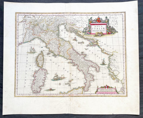
1640 Joan Blaeu Large Antique Map of Italy
- Title : Nova Italiae Delineatio
- Ref #: 17021
-
Condition: (A) Very Good Condition
- Size: 23 1/2in x 19 1/2in (595m x 495mm)
- Date : 1640
Description:
This original hand coloured copper-plate engraved antique map of Italy by Joan Blaeu was published in his 1640 edition of Atlas Novus.
General Definitions:
Paper thickness and quality: - Heavy and stable
Paper color : - off white
Age of map color: - Original
Colors used: - Red, yellow, green, blue
General color appearance: - Authentic
Paper size: - 23 1/2in x 19 1/2in (595m x 495mm)
Plate size: - 19 1/2in x 15in (595m x 380mm)
Margins: - Min 1in (25mm)
Imperfections:
Margins: - Small restoration to bottom margin centerfold, not affecting the image
Plate area: - Light creasing & uplift along centerfold
Verso: - Age toning along centerfold
Background:
Since classical times the countries bordering the enclosed waters of the Mediterranean had been well versed in the use of maps and sea charts and in Italy, more than anywhere else, the traditional knowledge was kept alive during the many hundreds of years following the collapse of the Roman Empire. By the thirteenth and fourteenth centuries the seamen of Venice, Genoa and Amalfi traded to far countries, from the Black Sea ports and the coasts of Palestine and Egypt in the East to Flanders and the southern coasts of England and Ireland in the West, their voyages guided by portulan charts and the use of the newly invented compass. For a time Italian supremacy in cartography passed to Aragon and the Catalan map makers based on Majorca, but by the year 1400 the power and wealth of the city states of Venice, Genoa, Florence and Milan surpassed any in Europe. Florence, especially, under the rule of the Medici family, became not only a great trading and financial centre but also the focal point of the rediscovery of the arts and learning of the ancient world. In this milieu a number of manuscript world maps were produced, of which one by Fra Mauro (c. 1459) is the most notable, but the event of the greatest importance in the history of cartography occurred in the year 1400 when a Florentine, Palla Strozzi, brought from Constantinople a Greek manuscript copy of Claudius Ptolemy's Geographia, which, 1,250 years after its compilation, came as a revelation to scholars in Western Europe. In the following fifty years or so manuscript copies, translated into Latin and other languages, became available in limited numbers but the invention of movable-type printing transformed the scene: the first copy without maps being printed in 1475 followed by many with copper-engraved maps, at Bologna in 1477, Rome 1478, 1490, 1507 and 1508, and Florence 1482.
About the year 1485 the first book of sea charts, compiled by Bartolommeo dalli Sonetti, was printed in Venice and in the first part of the sixteenth century a number of world maps were published, among them one compiled in 1506 by Giovanni Contarini, engraved by Francesco Rosselli, which was the first printed map to show the discoveries in the New World. In the following years there were many attractive and unusual maps of Islands (Isolano) by Bordone, Camocio and Porcacchi, but more important was the work of Giacomo (Jacopo) Gastaldi, a native of Piedmont who started life as an engineer in the service of the Venetian Republic before turning to cartography as a profession. His maps, produced in great variety and quantity, were beautifully drawn copperplate engravings and his style and techniques were widely copied by his contemporaries. From about 1550 to 1580 many of Gastaldi's maps appeared in the collections of maps known as Lafreri 'atlases', a term applied to groups of maps by different cartographers brought together in one binding. As the contents of such collections varied considerably they were no doubt assembled at the special request of wealthy patrons and are now very rare indeed.
About this time, for a variety of historical and commercial reasons, Italy's position as the leading trading and financial nation rapidly declined and with it her superiority in cartography was lost to the vigorous new states in the Low Countries. That is not to say, of course, that Italian skills as map makers were lost entirely for it was not until 1620 that the first printed maps of Italy by an Italian, Giovanni Magini, appeared, and much later in the century there were fine maps by Giacomo de Rossi and Vincenzo Coronelli, the latter leading a revival of interest in cartography at the end of the century. Coronelli was also famous for the construction of magnificent large-size globes and for the foundation in Venice in 1680 of the first geographical society.
In the eighteenth century the best-known names are Antonio Zatta, Rizzi-Zannoni and Giovanni Cassini.
We ought to mention the work of Baptista Boazio who drew a series of maps in A Summarie and True Discourse of Sir Francis Drake's West Indian Voyage, published in 1588-89, and who is especially noted for a very fine map of Ireland printed in 1599 which was incorporated in the later editions of the Ortelius atlases. It is perhaps appropriate also to refer to two English map makers who spent many years in exile in Italy: the first, George Lily, famous for the splendid map of the British Isles issued in Rome in 1546, and the second, Robert Dudley, who exactly one hundred years later was responsible for the finest sea atlas of the day, Dell' Arcano del Mare, published in Florence. Both of these are described in greater detail elsewhere in this handbook. (Ref: Tooley, Koeman)
Please note all items auctioned are genuine, we do not sell reproductions. A Certificate of Authenticity (COA) can be issued on request.
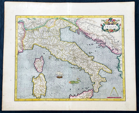
1628 Gerard Mercator Antique Map of Italy, Italia - Beautiful 1st Ed.
Antique Map
- Title : Italia
- Ref #: 35627
- Condition: (A+) Fine Condition
- Size: 22 1/2in x 18 1/2in (615mm x 470mm)
- Date: 1628
- Price: $1050.00US
Description:
This original beautifully hand coloured copper plate engraved antique map of Italy by Gerard Mercator, his first map of Italy for Atlas, was published in the 1628 Latin edition of Mercators Atlas Atlas Sive Cosmographicae Meditationes De Fabrica Mundi
This is a beautiful map with original hand colouring, heavy age toned paper with a deep impression. Beautiful map.
General Definitions:
Paper thickness and quality: - Heavy and stable
Paper color : - Off white
Age of map color: - Original
Colors used: - Yellow, green, blue, pink
General color appearance: - Authentic
Paper size: - 22 1/2in x 18 1/2in (615mm x 470mm)
Plate size: - 18 1/2in x 15in (470mm x 385mm)
Margins: - Min 1/2in (12mm)
Imperfections:
Margins: - None
Plate area: - Crease along centerfold
Verso: - None
Background:
Since classical times the countries bordering the enclosed waters of the Mediterranean had been well versed in the use of maps and sea charts and in Italy, more than anywhere else, the traditional knowledge was kept alive during the many hundreds of years following the collapse of the Roman Empire. By the thirteenth and fourteenth centuries the seamen of Venice, Genoa and Amalfi traded to far countries, from the Black Sea ports and the coasts of Palestine and Egypt in the East to Flanders and the southern coasts of England and Ireland in the West, their voyages guided by portulan charts and the use of the newly invented compass. For a time Italian supremacy in cartography passed to Aragon and the Catalan map makers based on Majorca, but by the year 1400 the power and wealth of the city states of Venice, Genoa, Florence and Milan surpassed any in Europe. Florence, especially, under the rule of the Medici family, became not only a great trading and financial centre but also the focal point of the rediscovery of the arts and learning of the ancient world. In this milieu a number of manuscript world maps were produced, of which one by Fra Mauro (c. 1459) is the most notable, but the event of the greatest importance in the history of cartography occurred in the year 1400 when a Florentine, Palla Strozzi, brought from Constantinople a Greek manuscript copy of Claudius Ptolemy's Geographia, which, 1,250 years after its compilation, came as a revelation to scholars in Western Europe. In the following fifty years or so manuscript copies, translated into Latin and other languages, became available in limited numbers but the invention of movable-type printing transformed the scene: the first copy without maps being printed in 1475 followed by many with copper-engraved maps, at Bologna in 1477, Rome 1478, 1490, 1507 and 1508, and Florence 1482.
About the year 1485 the first book of sea charts, compiled by Bartolommeo dalli Sonetti, was printed in Venice and in the first part of the sixteenth century a number of world maps were published, among them one compiled in 1506 by Giovanni Contarini, engraved by Francesco Rosselli, which was the first printed map to show the discoveries in the New World. In the following years there were many attractive and unusual maps of Islands (Isolano) by Bordone, Camocio and Porcacchi, but more important was the work of Giacomo (Jacopo) Gastaldi, a native of Piedmont who started life as an engineer in the service of the Venetian Republic before turning to cartography as a profession. His maps, produced in great variety and quantity, were beautifully drawn copperplate engravings and his style and techniques were widely copied by his contemporaries. From about 1550 to 1580 many of Gastaldi's maps appeared in the collections of maps known as Lafreri 'atlases', a term applied to groups of maps by different cartographers brought together in one binding. As the contents of such collections varied considerably they were no doubt assembled at the special request of wealthy patrons and are now very rare indeed.
About this time, for a variety of historical and commercial reasons, Italy's position as the leading trading and financial nation rapidly declined and with it her superiority in cartography was lost to the vigorous new states in the Low Countries. That is not to say, of course, that Italian skills as map makers were lost entirely for it was not until 1620 that the first printed maps of Italy by an Italian, Giovanni Magini, appeared, and much later in the century there were fine maps by Giacomo de Rossi and Vincenzo Coronelli, the latter leading a revival of interest in cartography at the end of the century. Coronelli was also famous for the construction of magnificent large-size globes and for the foundation in Venice in 1680 of the first geographical society.
In the eighteenth century the best-known names are Antonio Zatta, Rizzi-Zannoni and Giovanni Cassini.
We ought to mention the work of Baptista Boazio who drew a series of maps in A Summarie and True Discourse of Sir Francis Drake's West Indian Voyage, published in 1588-89, and who is especially noted for a very fine map of Ireland printed in 1599 which was incorporated in the later editions of the Ortelius atlases. It is perhaps appropriate also to refer to two English map makers who spent many years in exile in Italy: the first, George Lily, famous for the splendid map of the British Isles issued in Rome in 1546, and the second, Robert Dudley, who exactly one hundred years later was responsible for the finest sea atlas of the day, Dell' Arcano del Mare, published in Florence. Both of these are described in greater detail elsewhere in this handbook. (Ref: Tooley, Koeman)
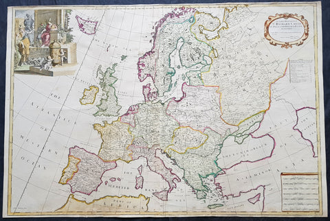
1712 John Senex Large Antique Map of Europe - Iceland, Poland, Russia, Italy
- Title : Europe Corrected from ye Observations Communicated to the Royal Society of London and Paris By John Senex & John Maxwell. Geographer to The Queen
- Size: 38in x 25 1/2in (970mm x 645mm)
- Condition: (A+) Fine Condition
- Date : 1712
- Ref #: 50657
Description:
This extraordinary, rare very large & beautifully hand coloured original antique map* of Europe - showing the Political Boundaries of the early 18th century - by John Senex & John Maxwell was published in the 1712 edition of their large Elephant Folio General Atlas. The map is dedicated to Sir Richard Child of Wansted Ist Earl of Tynley and Essex.
These large scale maps are scarce as damage and loss over time was frequent from both handling and difficulty storing safely.
General Definitions:
Paper thickness and quality: - Heavy and stable
Paper color : - off white
Age of map color: - Original & later
Colors used: - Yellow, green, blue, pink
General color appearance: - Authentic
Paper size: - 38in x 25 1/2in (970mm x 645mm)
Plate size: - 37in x 25in (930mm x 635mm)
Margins: - Min 1/4in (5mm)
Imperfections:
Margins: - Light soiling in margins
Plate area: - Light soiling along bottom of image, light creasing along foldsFolds as issued
Verso: - Light soiling in margins
Background:
A very interesting and scarce map of Europe at the beginning of the 18th century reflecting a continent before war and upheaval. The Ottoman Empire is still well entrenched stretching north to the southern borders of Austria & Hungary. Poland extends from the Baltic to the Black Sea encompassing much of SE Europe bordering Russia. Germany and Italy are shown as large extended countries on the map but were in truth made up of many large and small parochial states and Kingdoms. Overall a fantastic large and fascinating map entering a century of great upheaval. (Ref: Tooley; M&B)
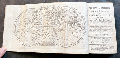
1759 Thomas Salmon Modern Gazetteer Antique Atlas with 7 Maps by Thomas Kitchin
- Title : The Modern Gazetteer: or a short View of the Severla Nations of the World.
- Ref : 17062
- Size: 16mo (7in x 5in)
- Date : 1759
- Condition: (A+) Fine Condition
Description:
This original antique Atlas The modern gazetteer: or, a short view of the several nations of the world, an early encyclopedia and atlas, with information on all parts of the known world at the time, was published by Thomas Salmon in 1759.
The Atlas is complete as called for and contains 7 maps by the famous English cartographer Thomas Kitchin:
1. World map - (12in x 7in 310mm x 180mm)
2. Africa - (8in x 7in 215mm x 180mm)
3. North America - (8in x 7in 215mm x 180mm)
4. South America - (8in x 7in 215mm x 180mm)
5. Asia - (8in x 7in 215mm x 180mm)
6. Europe - (8in x 7in 215mm x 180mm)
7. Germany - (8in x 7in 215mm x 180mm)
Atlas is in fine condition with beautiful and leather spine and boards. Light aging internally, folds as issued to maps.
General Definitions:
Paper thickness and quality: - Heavy and stable
Paper color : - off white
Age of map color: -
Colors used: -
General color appearance: -
Paper size: - 16mo (7in x 5in)
Plate size: - 16mo (7in x 5in)
Margins: - Min 1/2in (12mm)
Imperfections:
Margins: - None
Plate area: - None
Verso: - None
Background:
Thomas Kitchin 1718 - 84 was a London based engraver, cartographer, and publisher. He was born in London to a hat-dyer of the same name. At 14, Kitchin apprenticed under Emanuel Bowen, under whom he mastered the art of engraving. He married Bowen daughter, Sarah Bowen, and later inherited much of his preceptor\\\'s prosperous business. Their son, Thomas Bowen Kitchin, also an engraver joined the family business, which thereafter published in Thomas Kitchin and Son. From 1858 or so Kitchin was the engraver to the Duke of York, and from about 1773 acquired the title, \\\'Royal Hydrographer to King George III.\\\' He is responsible for numerous maps published in the The Star, Gentleman\\\'s Magazine, and London Magazine, as well as partnering with, at various times, with Thomas Jefferys, Emmanuel Bowen, Thomas Hinton, Issac Tayor, Andrew Dury, John Rocque, Louis de la Rochette, and Alexander Hogg, among others. Kitchin passed his business on to his son, Thomas Bowen Kitchin, who continued to republish many of his maps well after his death. Kitchin\\\'s apprentices included George Rollos, Bryant Lodge, Thomas Bowen Kitchin, Samuel Turner Sparrow, John Page, and Francis Vivares.
Atlases by Thomas Kitchin include:
Maps for the London Magazine 1747- 60.
Small English Atlas (Jefferys) 1749 -1787.
Large English Atlas (Bowen) 1755-1787.
The Royal English Atlas 1762-1828.
England Illustrated 1764.
A General Atlas (Sayer and Bennett, Laurie and Whittle) 1768 - 1810 .
Kitchin\\\'s Pocket Atlas 1769.
Kitchin\\\'s English Atlas 1770.
Antiquities of England and Wales (Henry Boswell) 1786.
A New Universal Atlas (Laurie and Whittle) 1789 - 1799
Salmon, Thomas 1679 - 1767
Salmon was an English historical and geographical writer.
Born at Meppershall in Bedfordshire, and baptised there on 2 February 1679, was son of Thomas Salmon, by his wife Katherine, daughter of John Bradshaw; Nathanael Salmon was his elder brother. William Cole wrote that he wrote much of his work in Cambridge, where he ran a coffee house, and then moved to London. He told Cole that he had spent time at sea, and in both the East and West Indies for some time. He also travelled in Europe.
In 1739 - 40 Salmon accompanied George Anson on his voyage round the world. He died on 20 January 1767.
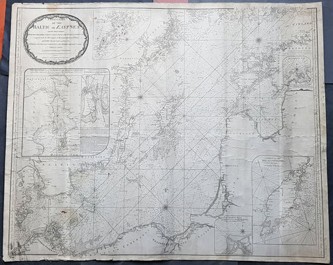
1794 Laurie & Whittle Large Very Rare Blueback Map, Sea Chart of The Baltic Sea
- Title : A New Chart of the Baltic or East Sea Drawn Principally from the Maritime Surveys Collected in the Russian Neptune compared with the Observations of the most experienceed Pilots, and Chiefly with the Charts and Draughts of Professor Christian Charles Lous, Nils Mareluis and James Schmid Published by Authority at Copenhagen, Stockholm and St Petersburg...London Published by Laurie & Whittle No 53 Fleet Street as the Act, 12th May, 1794
- Size: 48in x 39in (1.225m x 1.015mm)
- Condition: (A) Very Good Condition
- Date : 1794
- Ref #: 93046
Description:
This is a very large, extremely rare, copper-plate engraved and highly detailed working Blueback Nautical Chart or Maritime map of the Baltic or East Sea was engraved in 1794 and published by the Laurie & Whittle firm, London 1794. The details for this map have been collected from expeditions by the ship the Russian Neptune and Professor Christian Charles Lous, Nils Mareluis and James Schmid.
This rare Blueback map, a method of mounting working sea charts that was begun by Robert Sayer in the late 18th century. These working maps were extremely expensive to buy and labour intensive to put together so only a limited number were published and sold and even fewer have survived. I have found no other examples of this map either commercially or in other map collections.
The map depicts the Baltic Sea from Scandia Sweden & Pomeranian, Germany in the west to the Baltic States of Estonia and Latvia (Eastland, Livonia, Courland) & southern Finland in the east. The map is highly detailed with numerous cities are labelled, including Copenhagen, Stockholm (Christiana), Gdansk (Dazing), Tallinn (Revel), and Riga. Myriad depth soundings are indicated in the Baltic Sea and along the coastlines. Numerous inset maps are included, the first of Copenhagen and the Straits, the second of Stockholm and directions through the various channels and islands, the third inset is Rogerwick Bay, the fourth is the Island of Gottland and the fifth of Riga and Bay. Copious notes about sailing directions, channels, entrance to the Duna River.
General Definitions:
Paper thickness and quality: - Heavy and stable
Paper color : - off white
Age of map color: -
Colors used: -
General color appearance: -
Paper size: - 48in x 39in (1.225m x 1.015mm)
Plate size: - 48in x 39in (1.225m x 1.015mm)
Margins: - Min 1/2in (12mm)
Imperfections:
Margins: - Soiling, chipping to edges not affecting the image
Plate area: - Soiling, light brown spots top of map, light creasing
Verso: - Original Blueback
Background:
Blueback Charts
Blueback nautical charts began appearing in London in the late 18th century. Bluebacks, as they came to be called, were privately published large format nautical charts known for their distinctive blue paper backing. The backing, a commonly available blue manila paper traditionally used by publishers to warp unbound pamphlets, was adopted as a practical way to reinforce the low-quality paper used by private chart publishers in an effort to cut costs. The earliest known Blueback charts include a 1760 chart issued by Mount and Page, and a 1787 chart issued by Robert Sayer. The tradition took off in the early 19th century, when British publishers like John Hamilton Moore, Robert Blachford, James Imray, William Heather, John William Norie, Charles Wilson, David Steel, R. H. Laurie, and John Hobbs, among others, rose to dominate the chart trade. Bluebacks became so popular that the convention was embraced by chartmakerJacques Nicholas Bellins outside of England, including Americans Edmund March Blunt and George Eldridge, as well as Scandinavian, French, German, Russian, and Spanish chartmakers. Blueback charts remained popular until the late 19th century, when government subsidized organizations like the British Admiralty Hydrographic Office and the United States Coast Survey, began issuing their own superior charts on high quality paper that did not require reinforcement.
1698 Alexis Jaillot Large Antique Map European Russia, Poland, Baltics, Crimea
- Title : La Estats Du Czaar De La Russie Blanche Grand Duche Moscovie...
- Size: 37in x 24in (940mm x 610mm)
- Condition: (A+) Fine Condition
- Date : 1698
- Ref #: 61034
Description:
This very large, beautifully hand coloured original copper-plate engraved antique map of European Russia was published by Alexis Hubert Jaillot in the 1698 edition of his monumental Atlas Nouveau.
General Definitions:
Paper thickness and quality: - Heavy and stable
Paper color : - off white
Age of map color: - Original
Colors used: - Yellow, pink, green, blue
General color appearance: - Authentic
Paper size: - 37 1/2in x 24in (960mm x 620mm)
Plate size: - 35in x 23in (890mm x 585mm)
Margins: - Min 1in (25mm)
Imperfections:
Margins: - Age toning, several small repairs in margins, no loss
Plate area: - Age toning
Verso: - Age toning, several repairs, no loss
Background:
It is scarcely necessary to look at a map of Russia - with which we must include Siberia - to visualize the daunting task facing Russian map makers. Indeed, considering the vastness of their territory and the lack of skilled cartographers, it is surprising that relatively good maps were available for engraving and printing in most of the well known sixteenth and seventeenth century atlases. Generally, maps of that time were based on material brought back from Moscow by visitors from the West.
1696 Jaillot Large Antique Map Norway Sweden Finland Denmark - Latvia & Estonia
- Title : La Scandinavie...Hubert Jaillot 1696
- Size: 37in x 24in (940mm x 610mm)
- Condition: (A) Very Good Condition
- Date : 1696
- Ref #: 70329
Description:
This very large, beautifully hand coloured original copper-plate engraved antique map of Scandinavia, Norway, Sweden, Finland, Denmark along with Latvia & Estonia was engraved in 1696 - dated in cartouche - and was published by Alexis Hubert Jaillot in his monumental Atlas Nouveau.
General Definitions:
Paper thickness and quality: - Heavy and stable
Paper color : - off white
Age of map color: - Original
Colors used: - Yellow, pink, green, blue
General color appearance: - Authentic
Paper size: - 37in x 24in (940mm x 610mm)
Plate size: - 35in x 23in (890mm x 585mm)
Margins: - Min 1in (25mm)
Imperfections:
Margins: - Several small repairs to margins, no loss
Plate area: - Horizontal fold, light soiling and creasing
Verso: - Light soiling
Background:
Before the fifteenth century the people of Southern Europe had little geographical knowledge of the Scandinavian World except from sketchy detail shown in the Catalan Atlas (1375) and on a number of \" portolani\" embracing Denmark and the southern tip of Norway. It was not until 1427 that a manuscript map prepared about that time by Claudius Clavus (b.1388) a Dane who spent some time in Rome, made available to scholars a tolerable outline of the northern countries and Greenland. That was to remain the best map available for the rest of the century and it was used as the basis for maps of Scandinavia in early printed editions of Ptolemy. Others by Nicolaus Cusanus (1491) and Ehrhard Etzlaub (c. 1492) followed but, needless to say, these are extremely rare; even the later maps by Olaus Magnus and Marcus Jordan, where they have survived at all , are known only by a very few examples. In fact, apart from the rare appearance of an early Ptolemy map, the oldest of Scandinavia which a collector is likely to find are those of Munster\'s Cosmograhy first published in 1544. In the following centuries the few maps and charts complied in Scandinavia were usually published in Amsterdam, Antwerp, Paris or Nuremberg, the most important maps often being incorporated in the major Dutch, French & German Atlases. (Ref: Tooley; M&B)
1643 Joan Blaeu Antique Map of Ottoman, Turkish Empire - Saudi Arabia to Europe
- Title : Turcicum Imperium
- Size: 23 1/2in x 19 1/2in (595mm x 490mm)
- Condition: (A) Very Good Condition
- Date : 1643
- Ref #: 93351
Description:
This magnificent original hand coloured copper plate engraved antique map of The Turkish Empire in Europe and Asia from The Balkans to Saudi Arabia and most of Western Asia by Joan and Guillaume Blaeu was in the 1643 French edition of Atlas Nouvs.
The Blaeu family are considered one of the most revered map makers of the last 325 years and it is easy to see why in this beautiful original map. The high level of the topographical detail, the quality of the paper, the artistic professionalism of the engraving and the beauty of the original hand colouring combine to produce a work of art that is beautiful and informative of an era now long gone. (Ref: Tooley; Koeman; M&B)
General Definitions:
Paper thickness and quality: - Heavy and stable
Paper color : - off white
Age of map color: - Original
Colors used: - Yellow, green, blue, pink
General color appearance: - Authentic
Paper size: - 23 1/2in x 19 1/2in (595mm x 490mm)
Plate size: - 20 1/4in x 16 1/2in (515mm x 420mm)
Margins: - Min 1in (25mm)
Imperfections:
Margins: - Small professional invisible restoration in top margin, into top border
Plate area: - Small professional invisible restoration in top L & R
Verso: - Restoration as noted
Background:
This is the 17th century view of the Turkish Empire, including the Balkans in south-eastern Europe, the North African littoral, the Levant and the Arabian Peninsula in addition to the area of Modern Turkey.
Much of the place name information on this map is derived from the maps published in 1561 by the Italian mapmaker, Giacomo Gastaldi, whose maps exercised great influence over later European mapmakers, even throughout the 17th century.
Formidable through the barrier presented by the Turkish Empire in the Near East was, by the early years of the 17th century it was beginning to show signs of decadence and weakness, especially after the defeat of the Turkish navy at the hands of the combined Christian forces of Western Europe at the battle of Lepanto in 1571, from which Turkish naval power never fully recovered.
Centered on the palace of the Sultans at Constantinople, the administration of the empire was passed down through local rulers, the Beys, Deys and Pashas, who never lost an opportunity to enrich themselves and to develop often considerable powers of their own.
Further defeats of the Turks occurred in 1669 when Candia (Crete) was taken by the Venetians, and in 1683 when they suffered a humiliating defeat outside Wien (Vienna) at the north-western extremity of European Turkey.
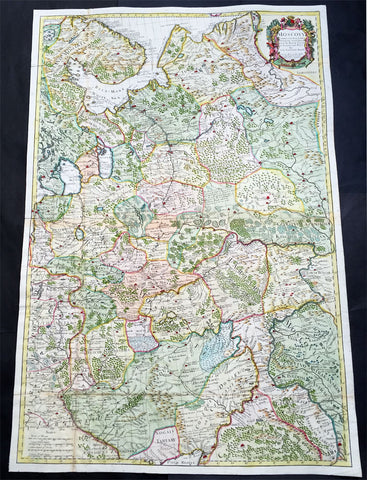
1712 Senex Very Large Antique Map of European Russia - Moscovy Corrected
- Title : Moscovy Corrected from ye Observations Communicated to the Royal Society of London and Paris By John Senex & John Maxwell. Sold by them at the Globe.....1712
- Ref #: 61030
- Size: 38in x 27in (990mm x 665mm)
- Date : 1712
- Condition: (A) Very Good Condition
Description:
This extraordinary, very large & beautifully hand coloured original antique map of European Russia - Moscovy - including parts of Scandinavia, the Baltic States & The Ukraine by John Senex & John Maxwell in 1712 - dated in title - and was published for Senex's large Elephant Folio General Atlas.
These large scale maps are scarce as damage and loss over time was frequent from both handling and difficulty storing safely.
General Description:
Paper thickness and quality: - Heavy and stable
Paper color: - white
Age of map color: - Original & later
Colors used: - Yellow, green, blue, red
General color appearance: - Authentic
Paper size: - 38in x 27in (990mm x 665mm)
Plate size: - 37in x 25in (930mm x 635mm)
Margins: - min. 1/2in (12mm)
Imperfections:
Margins: - None
Plate area: - Folds as issued
Verso: - Folds re-enforced on verso
Background: It is scarcely necessary to look at a map of Russia - with which we must include Siberia - to visualize the daunting task facing Russian map makers. Indeed, considering the vastness of their territory and the lack of skilled cartographers, it is surprising that relatively good maps were available for engraving and printing in most of the well known sixteenth and seventeenth century atlases. Generally, maps of that time were based on material brought back from Moscow by visitors from the West. (Ref: Tooley; M&B)
1845-63 John Gould Large Antique Print The Mammals of Australia - Tree Kangaroo
- Title : Dendrolagus Ursinus, Mull....H C Richter del et lith....C Hullmandel Imp.
- Ref #: 93441
- Size: 22in x 15in (560mm x 385mm)
- Date : 1845–63
- Condition: (A+) Fine Condition
Description:
This large rare original hand coloured lithograph antique print of The Ursine Tree Kangaroo, by the artist HC Richter was printed by Charles Joseph Hullmandel 1789 – 1850 in the famous Naturalists John Goulds The Mammals of Australiapublished between 1845–63.
General Definitions:
Paper thickness and quality: - Heavy and stable
Paper color : - off white
Age of map color: - Original
Colors used: - Blue, pink, red, green, yellow
General color appearance: - Authentic
Paper size: - 22in x 15in (560mm x 385mm)
Plate size: - 22in x 15in (560mm x 385mm)
Margins: - Min 1in (25mm)
Imperfections:
Margins: - Light age toning
Plate area: - None
Verso: - None
Background:
The Mammals of Australia is a three-volume work written and published by John Gould between 1845–63. It contains 182 illustrations by the author and its artist H. C. Richter. It was intended to be a complete survey of the novel species of mammals, such as the marsupials, discovered in the colonies of Australia.
The author, John Gould, best known for The Birds of Australia and other major works of ornithology, visited Australia in 1838. In his introduction, Gould says:.....It was not until I arrived in the country, and found myself surrounded by objects as strange as if I had been transported to another planet, that I conceived the idea of devoting a portion of my attention to the mammalian class of its extraordinary fauna......During his short stay he made observations on the natural history and employed his skills as a taxidermist to obtain specimens.
The publication of this major work by Gould followed his A Monograph of the Macropodidae or Family of Kangaroos in 1841. This work was the first comprehensive survey of Australian mammals, and gave an account of their classification and description. Gould also included the indigenous names for the species from the lists he made while in Australia. He used these names to make requests of the local peoples for his specimens, and recorded the regions where the names were used. This conserved a number of common names, such as dibbler (Parantechinus apicalis), which were later recommended by authorities.
The large lithographs reproduced the artwork of Richter, after the drawings and watercolours made in Australia by Gould and his wife, Elizabeth. (The contribution by Elizabeth Gould was uncredited). These were hand-coloured by a group of artists, led by Gabriel Bayfield, that required the completion of 26,572 plates. The illustrations produced during their visit to Australia were supplemented by the preserved specimens returned to England and detailed the characteristics of the species. These illustrations have become iconic images of the mammals of Australia. Among the best known of the illustrations from the work are the two of Thylacinus cynocephalus (Tasmanian tiger), copied since its publication and the most frequently reproduced, made more recognizable by Cascade Brewerys appropriation for its label in 1987. The government of Tasmania published a monochromatic reproduction of the same image in 1934, the author Louisa Anne Meredith also copied it for Tasmanian Friends and Foes (1881).
The Mammals of Australia was published by subscription in the format Imperial Folio; 13 parts in three volumes were issued from 1845 until 1863. To these the author added An Introduction to The Mammals of Australia (1863) in a separate work. This provided corrections and updates, a new preface, introduction, and a list of the mammals of the three volumes. The first two volumes were complete surveys of orders Marsupiata (marsupials), and, with Rodentia in the third, it formed the sum of known mammalian species of Australia. With the addition of those contained in the later Introduction the total of species described reached 166. The same work notes the exclusion of marine mammals such as whales from the volumes, but reprints a manuscript by Charles Coxen on the dugong.
Beyond the scientific value of this comprehensive survey, the document is cited in reference to its subjects conservation. Some of the species included in the work, such as Onychogalea lunata (crescent nailtail wallaby), have since succumbed to changes in land use since European colonisation.
The work was received with acclaim, but the high cost of production, especially of the coloured plates, reduced its accessibility. The original listed price was £41 for the complete set of volumes. The public curiosity for the unique fauna of Australia was met by this handsomely illustrated and comprehensive survey, and it spawned imitations in Australia. The curator of the Australian Museum, Gerard Krefft, produced the more affordable The Mammals of Australia (1871); intended for educational purposes and influenced by Goulds illustrations. Gracius Broinowskis abandoned work, Birds and Mammals of Australia (1884), so closely imitated the plates that an injunction was threatened by its publisher.
Gould, John FRS 1804 – 1881
Gould was an English ornithologist and bird artist. He published a number of monographs on birds, illustrated by plates that he produced with the assistance of his wife, Elizabeth Gould, and several other artists including Edward Lear, Henry Constantine Richter, Joseph Wolf and William Matthew Hart. He has been considered the father of bird study in Australia and the Gould League in Australia is named after him. His identification of the birds now nicknamed Darwins finches played a role in the inception of Darwins theory of evolution by natural selection. Goulds work is referenced in Charles Darwins book, On the Origin of Species.
Gould was born in Lyme Regis the first son of a gardener. He and the boy probably had a scanty education. Shortly afterwards his father obtained a position on an estate near Guildford, Surrey, and then in 1818 Gould became foreman in the Royal Gardens of Windsor. He was for some time under the care of J. T. Aiton, of the Royal Gardens of Windsor. The young Gould started training as a gardener, being employed under his father at Windsor from 1818 to 1824, and he was subsequently a gardener at Ripley Castle in Yorkshire. He became an expert in the art of taxidermy. In 1824 he set himself up in business in London as a taxidermist, and his skill helped him to become the first Curator and Preserver at the museum of the Zoological Society of London in 1827.
Goulds position brought him into contact with the countrys leading naturalists. This meant that he was often the first to see new collections of birds given to the Zoological Society of London. In 1830 a collection of birds arrived from the Himalayas, many not previously described. Gould published these birds in A Century of Birds from the Himalaya Mountains (1830–1832). The text was by Nicholas Aylward Vigors and the illustrations were drawn and lithographed by Goulds wife Elizabeth Coxen Gould. Most of Goulds work were rough sketches on paper from which other artists created the lithographic plates.
This work was followed by four more in the next seven years, including Birds of Europe in five volumes. It was completed in 1837; Gould wrote the text, and his clerk, Edwin Prince, did the editing. The plates were drawn and lithographed by Elizabeth Coxen Gould. A few of the illustrations were made by Edward Lear as part of his Illustrations of the Family of Psittacidae in 1832. Lear, however, was in financial difficulty, and he sold the entire set of lithographs to Gould. The books were published in a very large size, imperial folio, with magnificent coloured plates. Eventually 41 of these volumes were published, with about 3000 plates. They appeared in parts at £3 3s. a number, subscribed for in advance, and in spite of the heavy expense of preparing the plates, Gould succeeded in making his ventures pay, realising a fortune. This was a busy period for Gould who also published Icones Avium in two parts containing 18 leaves of bird studies on 54 cm plates as a supplement to his previous works. No further monographs were published as in 1838 he and his wife moved to Australia to work on the Birds of Australia. Shortly after their return to England, his wife died in 1841. Elizabeth Gould completed 84 plates for Birds of Australia before her death.
When Charles Darwin presented his mammal and bird specimens collected during the second voyage of HMS Beagle to the Zoological Society of London on 4 January 1837, the bird specimens were given to Gould for identification. He set aside his paying work and at the next meeting on 10 January reported that birds from the Galápagos Islands which Darwin had thought were blackbirds, gross-bills and finches were in fact a series of ground Finches which are so peculiar as to form an entirely new group, containing 12 species. This story made the newspapers. In March, Darwin met Gould again, learning that his Galápagos wren was another species of finch and the mockingbirds he had labelled by island were separate species rather than just varieties, with relatives on the South American mainland. Subsequently, Gould advised that the smaller southern Rhea specimen that had been rescued from a Christmas dinner was a separate species which he named Rhea darwinii, whose territory overlapped with the northern rheas. Darwin had not bothered to label his finches by island, but others on the expedition had taken more care. He now sought specimens collected by captain Robert FitzRoy and crewmen. From them he was able to establish that the species were unique to islands, an important step on the inception of his theory of evolution by natural selection. Goulds work on the birds was published between 1838 and 1842 in five numbers as Part 3 of Zoology of the Voyage of H.M.S. Beagle, edited by Charles Darwin. Elizabeth Gould illustrated all the plates for Part 3.
In 1838 the Goulds sailed to Australia, intending to study the birds of that country and be the first to produce a major work on the subject. They took with them the collector John Gilbert. They arrived in Tasmania in September, making the acquaintance of the governor Sir John Franklin and his wife. Gould and Gilbert collected on the island. In February 1839 Gould sailed to Sydney, leaving his pregnant wife with the Franklins. He travelled to his brother-in-laws station at Yarrundi, spending his time searching for bowerbirds in the Liverpool Range. In April he returned to Tasmania for the birth of his son. In May he sailed to Adelaide to meet Charles Sturt, who was preparing to lead an expedition to the Murray River. Gould collected in the Mount Lofty range, the Murray Scrubs and Kangaroo Island, returning again to Hobart in July. He then travelled with his wife to Yarrundi. They returned home to England in May 1840.
The result of the trip was The Birds of Australia (1840–48). It included a total of 600 plates in seven volumes; 328 of the species described were new to science and named by Gould. He also published A Monograph of the Macropodidae, or Family of Kangaroos (1841–1842) and the three volume work The Mammals of Australia (1849–1861).
Elizabeth died in 1841 after the birth of their eighth child, Sarah, and Goulds books subsequently used illustrations by a number of artists, including Henry Constantine Richter, William Matthew Hart and Joseph Wolf.
Throughout his professional life Gould had a strong interest in hummingbirds. He accumulated a collection of 320 species, which he exhibited at the Great Exhibition of 1851. Despite his interest, Gould had never seen a live hummingbird. In May 1857 he travelled to the United States with his second son, Charles. He arrived in New York too early in the season to see hummingbirds in that city, but on 21 May 1857, in Bartrams Gardens in Philadelphia, he finally saw his first live one, a ruby-throated hummingbird. He then continued to Washington D.C. where he saw large numbers in the gardens of the Capitol. Gould attempted to return to England with live specimens, but, as he was not aware of the conditions necessary to keep them, they only lived for two months at most.
Gould published: A Monograph of the Trochilidae or Humming Birds with 360 plates (1849–61); The Mammals of Australia (1845–63), Handbook to the Birds of Australia (1865), The Birds of Asia (1850–83), The Birds of Great Britain (1862–73) and The Birds of New Guinea and the adjacent Papuan Islands (1875–88).
The University of Glasgow, which owns a copy of Birds of Great Britain, describes John Gould as the greatest figure in bird illustration after Audubon, and auctioneers Sotherans describe the work as Goulds pride and joy.
Gould had already published some of the illustrations in Birds of Europe, but Birds of Great Britain represents a development of his aesthetic style in which he adds illustrations of nests and young on a large scale.
Sotherans Co. reports that Gould published the book himself, producing 750 copies, which remain sought after both as complete volumes, and as individual plates, currently varying in price from £450 – £850. The University of Glasgow records that the volumes were issued in London in 25 parts, to make the complete set, between 1863 and 1873, and each set contained 367 coloured lithographs.
Gould undertook an ornithological tour of Scandinavia in 1856, in preparation for the work, taking with him the artist Henry Wolf who drew 57 of the plates from Goulds preparatory sketches. According to The University of Glasgow Goulds skill was in rapidly producing rough sketches from nature (a majority of the sketches were drawn from newly killed specimens) capturing the distinctiveness of each species. Gould then oversaw the process whereby his artists worked his sketches up into the finished drawings, which were made into coloured lithographs by engraver William Hart.
There were problems: the stone engraving of the snowy owl in volume I was dropped and broken at an early stage in the printing. Later issues of this plate show evidence of this damage and consequently the early issue – printed before the accident – are considered more desirable.
The lithographs were hand coloured. In the introduction for the work, Gould states every sky with its varied tints and every feather of each bird were coloured by hand; and when it is considered that nearly two hundred and eighty thousand illustrations in the present work have been so treated, it will most likely cause some astonishment to those who give the subject a thought.
The work has gathered critical acclaim: according to Mullens and Swann, Birds of Great Britain is the most sumptuous and costly of British bird books, whilst Wood describes it as a magnificent work. Isabella Tree writes that it was seen – perhaps partly because its subject was British, as the culmination of [his] ... genius
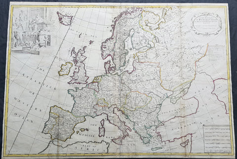
1712 John Senex Large Antique Map of Europe - Large Poland, Russia, Italy, Spain
- Title : Europe Corrected from ye Observations Communicated to the Royal Society of London and Paris By John Senex, Geographer to The Queen
- Size: 35 1/2in x 26in (900mm x 660mm)
- Condition: (A) Very Good Condition
- Date : 1712
- Ref #: 70707
Description:
This extraordinary, rare very large & beautifully hand coloured original copper-plate engraved antique map of Europe - showing the Political Boundaries of the early 18th century - by John Senex was published in the 1712 edition of his large Elephant Folio General Atlas. The map is dedicated to Sir Richard Child of Wansted Ist Earl of Tynley and Essex.This map is in VG condition. These large scale maps are scarce due mainly to their size, with damage and loss over time inevitable.
General Definitions:
Paper thickness and quality: - Heavy and stable
Paper color : - off white
Age of map color: - Original
Colors used: - Yellow, green, blue, pink
General color appearance: - Authentic
Paper size: - 35 1/2in x 26in (900mm x 660mm)
Plate size: - 35 1/2in x 26in (900mm x 660mm)
Margins: - Min 1/2in (12mm)
Imperfections:
Margins: - Several small repairs to margins
Plate area: - Soiling to & several professional repairs to folds
Verso: - Soiling
Background:
A very interesting and scarce map of Europe at the beginning of the 18th century reflecting a continent before war and upheaval. The Ottoman Empire is still well entrenched stretching north to the southern borders of Austria & Hungary. Poland extends from the Baltic to the Black Sea encompassing much of SE Europe bordering Russia. Germany and Italy are shown as large extended countries on the map but were in truth made up of many large and small parochial states and Kingdoms. Overall a fantastic large and fascinating map entering a century of great upheaval. (Ref: Tooley; M&B)
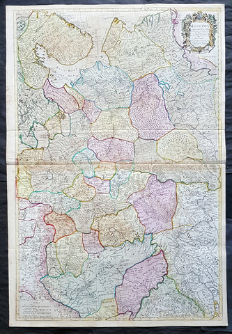
1712 Senex Large Original Antique Map of Europe Russia, Moscow - Finland to Azov
- Title : Moscovy Corrected from ye Observations Communicated to the Royal Society of London and Paris By John Senex & John Maxwell. Sold by them at the Globe.....1712
- Ref #: 82074
- Size: 39 1/2in x 26 1/2in (980mm x 675mm)
- Date : 1712
- Condition: (A) Very Good Condition
Description:
This extraordinary, very large & beautifully hand coloured original antique map of European Russia - Moscovy - including parts of Scandinavia, the Baltic States & The Ukraine by John Senex & John Maxwell in 1712 - dated in title - and was published for Senex's large Elephant Folio General Atlas.
These large scale maps are scarce as damage and loss over time was frequent from both handling and difficulty storing safely.
Background: It is scarcely necessary to look at a map of Russia - with which we must include Siberia - to visualize the daunting task facing Russian map makers. Indeed, considering the vastness of their territory and the lack of skilled cartographers, it is surprising that relatively good maps were available for engraving and printing in most of the well known sixteenth and seventeenth century atlases. Generally, maps of that time were based on material brought back from Moscow by visitors from the West. (Ref: Tooley; M&B)
General Description:
Paper thickness and quality: - Heavy and stable
Paper color: - white
Age of map color: - Original & later
Colors used: - Yellow, green, blue, red
General color appearance: - Authentic
Paper size: - 39 1/2in x 26 1/2in (980mm x 675mm)
Plate size: - 37in x 25in (930mm x 635mm)
Margins: - min. 1/2in (12mm)
Imperfections:
Margins: - None
Plate area: - Light age toning along centerfold & top of image
Verso: - Folds re-enforced on verso
1845-63 John Gould Large Antique Print of Tree Kangaroo The Mammals of Australia
- Title : Dendrolagus Inustus, Mull....H C Richter del et lith....C Hullmandel Imp.
- Ref #: 93442
- Size: 22in x 15in (560mm x 385mm)
- Date : 1845–63
- Condition: (A+) Fine Condition
Description:
This large rare original hand coloured lithograph antique print of The Grizzled Tree Kangaroo, by the artist HC Richter was printed by Charles Joseph Hullmandel 1789 – 1850 in the famous Naturalists John Goulds The Mammals of Australiapublished between 1845–63.
General Definitions:
Paper thickness and quality: - Heavy and stable
Paper color : - off white
Age of map color: - Original
Colors used: - Blue, pink, red, green, yellow
General color appearance: - Authentic
Paper size: - 22in x 15in (560mm x 385mm)
Plate size: - 22in x 15in (560mm x 385mm)
Margins: - Min 1in (25mm)
Imperfections:
Margins: - Light age toning
Plate area: - None
Verso: - None
Background:
The Mammals of Australia is a three-volume work written and published by John Gould between 1845–63. It contains 182 illustrations by the author and its artist H. C. Richter. It was intended to be a complete survey of the novel species of mammals, such as the marsupials, discovered in the colonies of Australia.
The author, John Gould, best known for The Birds of Australia and other major works of ornithology, visited Australia in 1838. In his introduction, Gould says:.....It was not until I arrived in the country, and found myself surrounded by objects as strange as if I had been transported to another planet, that I conceived the idea of devoting a portion of my attention to the mammalian class of its extraordinary fauna......During his short stay he made observations on the natural history and employed his skills as a taxidermist to obtain specimens.
The publication of this major work by Gould followed his A Monograph of the Macropodidae or Family of Kangaroos in 1841. This work was the first comprehensive survey of Australian mammals, and gave an account of their classification and description. Gould also included the indigenous names for the species from the lists he made while in Australia. He used these names to make requests of the local peoples for his specimens, and recorded the regions where the names were used. This conserved a number of common names, such as dibbler (Parantechinus apicalis), which were later recommended by authorities.
The large lithographs reproduced the artwork of Richter, after the drawings and watercolours made in Australia by Gould and his wife, Elizabeth. (The contribution by Elizabeth Gould was uncredited). These were hand-coloured by a group of artists, led by Gabriel Bayfield, that required the completion of 26,572 plates. The illustrations produced during their visit to Australia were supplemented by the preserved specimens returned to England and detailed the characteristics of the species. These illustrations have become iconic images of the mammals of Australia. Among the best known of the illustrations from the work are the two of Thylacinus cynocephalus (Tasmanian tiger), copied since its publication and the most frequently reproduced, made more recognizable by Cascade Brewerys appropriation for its label in 1987. The government of Tasmania published a monochromatic reproduction of the same image in 1934, the author Louisa Anne Meredith also copied it for Tasmanian Friends and Foes (1881).
The Mammals of Australia was published by subscription in the format Imperial Folio; 13 parts in three volumes were issued from 1845 until 1863. To these the author added An Introduction to The Mammals of Australia (1863) in a separate work. This provided corrections and updates, a new preface, introduction, and a list of the mammals of the three volumes. The first two volumes were complete surveys of orders Marsupiata (marsupials), and, with Rodentia in the third, it formed the sum of known mammalian species of Australia. With the addition of those contained in the later Introduction the total of species described reached 166. The same work notes the exclusion of marine mammals such as whales from the volumes, but reprints a manuscript by Charles Coxen on the dugong.
Beyond the scientific value of this comprehensive survey, the document is cited in reference to its subjects conservation. Some of the species included in the work, such as Onychogalea lunata (crescent nailtail wallaby), have since succumbed to changes in land use since European colonisation.
The work was received with acclaim, but the high cost of production, especially of the coloured plates, reduced its accessibility. The original listed price was £41 for the complete set of volumes. The public curiosity for the unique fauna of Australia was met by this handsomely illustrated and comprehensive survey, and it spawned imitations in Australia. The curator of the Australian Museum, Gerard Krefft, produced the more affordable The Mammals of Australia (1871); intended for educational purposes and influenced by Goulds illustrations. Gracius Broinowskis abandoned work, Birds and Mammals of Australia (1884), so closely imitated the plates that an injunction was threatened by its publisher.
Gould, John FRS 1804 – 1881
Gould was an English ornithologist and bird artist. He published a number of monographs on birds, illustrated by plates that he produced with the assistance of his wife, Elizabeth Gould, and several other artists including Edward Lear, Henry Constantine Richter, Joseph Wolf and William Matthew Hart. He has been considered the father of bird study in Australia and the Gould League in Australia is named after him. His identification of the birds now nicknamed Darwins finches played a role in the inception of Darwins theory of evolution by natural selection. Goulds work is referenced in Charles Darwins book, On the Origin of Species.
Gould was born in Lyme Regis the first son of a gardener. He and the boy probably had a scanty education. Shortly afterwards his father obtained a position on an estate near Guildford, Surrey, and then in 1818 Gould became foreman in the Royal Gardens of Windsor. He was for some time under the care of J. T. Aiton, of the Royal Gardens of Windsor. The young Gould started training as a gardener, being employed under his father at Windsor from 1818 to 1824, and he was subsequently a gardener at Ripley Castle in Yorkshire. He became an expert in the art of taxidermy. In 1824 he set himself up in business in London as a taxidermist, and his skill helped him to become the first Curator and Preserver at the museum of the Zoological Society of London in 1827.
Goulds position brought him into contact with the countrys leading naturalists. This meant that he was often the first to see new collections of birds given to the Zoological Society of London. In 1830 a collection of birds arrived from the Himalayas, many not previously described. Gould published these birds in A Century of Birds from the Himalaya Mountains (1830–1832). The text was by Nicholas Aylward Vigors and the illustrations were drawn and lithographed by Goulds wife Elizabeth Coxen Gould. Most of Goulds work were rough sketches on paper from which other artists created the lithographic plates.
This work was followed by four more in the next seven years, including Birds of Europe in five volumes. It was completed in 1837; Gould wrote the text, and his clerk, Edwin Prince, did the editing. The plates were drawn and lithographed by Elizabeth Coxen Gould. A few of the illustrations were made by Edward Lear as part of his Illustrations of the Family of Psittacidae in 1832. Lear, however, was in financial difficulty, and he sold the entire set of lithographs to Gould. The books were published in a very large size, imperial folio, with magnificent coloured plates. Eventually 41 of these volumes were published, with about 3000 plates. They appeared in parts at £3 3s. a number, subscribed for in advance, and in spite of the heavy expense of preparing the plates, Gould succeeded in making his ventures pay, realising a fortune. This was a busy period for Gould who also published Icones Avium in two parts containing 18 leaves of bird studies on 54 cm plates as a supplement to his previous works. No further monographs were published as in 1838 he and his wife moved to Australia to work on the Birds of Australia. Shortly after their return to England, his wife died in 1841. Elizabeth Gould completed 84 plates for Birds of Australia before her death.
When Charles Darwin presented his mammal and bird specimens collected during the second voyage of HMS Beagle to the Zoological Society of London on 4 January 1837, the bird specimens were given to Gould for identification. He set aside his paying work and at the next meeting on 10 January reported that birds from the Galápagos Islands which Darwin had thought were blackbirds, gross-bills and finches were in fact a series of ground Finches which are so peculiar as to form an entirely new group, containing 12 species. This story made the newspapers. In March, Darwin met Gould again, learning that his Galápagos wren was another species of finch and the mockingbirds he had labelled by island were separate species rather than just varieties, with relatives on the South American mainland. Subsequently, Gould advised that the smaller southern Rhea specimen that had been rescued from a Christmas dinner was a separate species which he named Rhea darwinii, whose territory overlapped with the northern rheas. Darwin had not bothered to label his finches by island, but others on the expedition had taken more care. He now sought specimens collected by captain Robert FitzRoy and crewmen. From them he was able to establish that the species were unique to islands, an important step on the inception of his theory of evolution by natural selection. Goulds work on the birds was published between 1838 and 1842 in five numbers as Part 3 of Zoology of the Voyage of H.M.S. Beagle, edited by Charles Darwin. Elizabeth Gould illustrated all the plates for Part 3.
In 1838 the Goulds sailed to Australia, intending to study the birds of that country and be the first to produce a major work on the subject. They took with them the collector John Gilbert. They arrived in Tasmania in September, making the acquaintance of the governor Sir John Franklin and his wife. Gould and Gilbert collected on the island. In February 1839 Gould sailed to Sydney, leaving his pregnant wife with the Franklins. He travelled to his brother-in-laws station at Yarrundi, spending his time searching for bowerbirds in the Liverpool Range. In April he returned to Tasmania for the birth of his son. In May he sailed to Adelaide to meet Charles Sturt, who was preparing to lead an expedition to the Murray River. Gould collected in the Mount Lofty range, the Murray Scrubs and Kangaroo Island, returning again to Hobart in July. He then travelled with his wife to Yarrundi. They returned home to England in May 1840.
The result of the trip was The Birds of Australia (1840–48). It included a total of 600 plates in seven volumes; 328 of the species described were new to science and named by Gould. He also published A Monograph of the Macropodidae, or Family of Kangaroos (1841–1842) and the three volume work The Mammals of Australia (1849–1861).
Elizabeth died in 1841 after the birth of their eighth child, Sarah, and Goulds books subsequently used illustrations by a number of artists, including Henry Constantine Richter, William Matthew Hart and Joseph Wolf.
Throughout his professional life Gould had a strong interest in hummingbirds. He accumulated a collection of 320 species, which he exhibited at the Great Exhibition of 1851. Despite his interest, Gould had never seen a live hummingbird. In May 1857 he travelled to the United States with his second son, Charles. He arrived in New York too early in the season to see hummingbirds in that city, but on 21 May 1857, in Bartrams Gardens in Philadelphia, he finally saw his first live one, a ruby-throated hummingbird. He then continued to Washington D.C. where he saw large numbers in the gardens of the Capitol. Gould attempted to return to England with live specimens, but, as he was not aware of the conditions necessary to keep them, they only lived for two months at most.
Gould published: A Monograph of the Trochilidae or Humming Birds with 360 plates (1849–61); The Mammals of Australia (1845–63), Handbook to the Birds of Australia (1865), The Birds of Asia (1850–83), The Birds of Great Britain (1862–73) and The Birds of New Guinea and the adjacent Papuan Islands (1875–88).
The University of Glasgow, which owns a copy of Birds of Great Britain, describes John Gould as the greatest figure in bird illustration after Audubon, and auctioneers Sotherans describe the work as Goulds pride and joy.
Gould had already published some of the illustrations in Birds of Europe, but Birds of Great Britain represents a development of his aesthetic style in which he adds illustrations of nests and young on a large scale.
Sotherans Co. reports that Gould published the book himself, producing 750 copies, which remain sought after both as complete volumes, and as individual plates, currently varying in price from £450 – £850. The University of Glasgow records that the volumes were issued in London in 25 parts, to make the complete set, between 1863 and 1873, and each set contained 367 coloured lithographs.
Gould undertook an ornithological tour of Scandinavia in 1856, in preparation for the work, taking with him the artist Henry Wolf who drew 57 of the plates from Goulds preparatory sketches. According to The University of Glasgow Goulds skill was in rapidly producing rough sketches from nature (a majority of the sketches were drawn from newly killed specimens) capturing the distinctiveness of each species. Gould then oversaw the process whereby his artists worked his sketches up into the finished drawings, which were made into coloured lithographs by engraver William Hart.
There were problems: the stone engraving of the snowy owl in volume I was dropped and broken at an early stage in the printing. Later issues of this plate show evidence of this damage and consequently the early issue – printed before the accident – are considered more desirable.
The lithographs were hand coloured. In the introduction for the work, Gould states every sky with its varied tints and every feather of each bird were coloured by hand; and when it is considered that nearly two hundred and eighty thousand illustrations in the present work have been so treated, it will most likely cause some astonishment to those who give the subject a thought.
The work has gathered critical acclaim: according to Mullens and Swann, Birds of Great Britain is the most sumptuous and costly of British bird books, whilst Wood describes it as a magnificent work. Isabella Tree writes that it was seen – perhaps partly because its subject was British, as the culmination of [his] ... genius
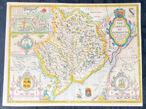
1676 John Speed Antique County Map of MonmouthShire - Beautiful Original Colour
Antique Map
- Title : The Countye of Monmouth Anno 1610
- Date : 1676
- Size: 21in x 16in (535mm x 405mm)
- Condition: (A+) Fine Condition
- Ref: 35623
Description:
This original hand coloured copper plate engraved antique county map & views of Monmouth Shire and Monmouth City by John Speed was published in the 1676 Bassett & Chiswell edition of Speeds famous atlas The Theatre of the Empire of Great Britaine.
The map is embellished with the famous birds-eye views of the county and city with descriptive text on the verso.
General Definitions:
Paper thickness and quality: - Heavy and stable
Paper color : - off white
Age of map color: - Original
Colors used: - Yellow, green, blue, pink
General color appearance: - Authentic
Paper size: - 21in x 16in (535mm x 405mm)
Plate size: - 20 1/2in x 15 1/4in (520mm x 385mm)
Margins: - Min 1/2in (10mm)
Imperfections:
Margins: - Age toning
Plate area: - Age toning
Verso: - Age toning
Background:
John Speeds The Theatre of the Empire of Great Britaine was published in 1610/11 by John Sudbury and George Humble, and contained the first set of individual county maps of England and Wales besides maps of Ireland and a general map of Scotland. Most, but not all, of the county maps have town plans on them; those showing a Scale of Passes being the places he had mapped himself. The county maps were the first consistent attempt to show territorial divisions, such as boundaries of hundreds, but it was Speed’s town plans that were a major innovation and probably his greatest contribution to British cartography. The Theatre was an immediate success: the first print run of around 500 copies must have sold quickly because many editions followed. Sudbury and Humble realized, given the increasing popularity of both county and world atlases and in the light of the success of Abraham Ortelius’s Theatrum Orbis Terrarum, the potential demand for an English world atlas.
In 1627, two years before his death, Speed published Prospect of the Most Famous Parts of the World with 21 finely engraved maps, which was the first world atlas produced by an Englishman. There is a fascinating text describing the areas shown on the back of the maps in English, although a rare edition of 1616 of the British maps has a Latin text – this is believed to have been produced for the Continental market. Its maps are famous for their bordering panels of national characters in local costume and panoramic views depicting the areas of major towns and cities. Much of the engraving was done in Amsterdam at the workshop of Jodocus Hondius. The maps of the world and America show California as an island and are amongst the earliest ever printed to depict this seventeenth-century cartographic myth.
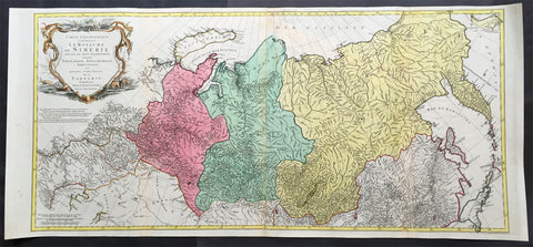
1770 Tobias Lotter Very Large Antique Map of Russia & Siberia
- Title : Carte géographique contenant le royaume de Sibérie
- Ref #: 61039
- Size: 44in x 20 1/2in (1.15m x 520mm)
- Date : 1770
- Condition: (A) Very Good Condition
Description:
This scarce, very large beautifully hand coloured original antique map of Russia and Siberia with parts of China was published by Tobias Conrad Lotter in 1770.
Background: Rare, highly detailed map of Russia & Siberia that is subdivided into provinces, namely Tobolsk, Jenissejesk, Irkutsk, and outer parts of the Tartary. In upper right corner inset-map of the Chukchi (Chukotsk) Peninsula. On the left side sheet is a large title cartouche set in a steppe landscape with reindeer sledge, whale and polar bears. Scale ca. 1 : 13,000,000 and engraved by Matthäus Albrecht Lotter for Tobias Conrad Lotter.
In about 1770 a map of Russia & Siberia by Ivan Fomic Truscot (1721-1786, comp. BMC XXII, 353) was published, that comprised the West Siberian states Tobolsk and Yeniseiesk only, but may have been quite available to Lotter, just as also the German edition of the third Russian general map by Truscot and Jacob F. Schmidt of 1776 was published by Lotter in 1784.
The comparison of the Asian north-eastern coast from Japan up to Cape Szalaginskoi (Cape Shelagskiy) together with the offshore islands there results in an astonishing similarity with representation and designation on Rigobert Bonne’s maps of Russia and the Chinese Tartary published by Lattré in Paris in 1771. Especially striking the form of Sakhalin that hitherto – but also still on the Truscot map of 1776 – appears far more stocky, here though shows a slimmer shape considerably closer to reality. Cape Patience known at least since the 1743 Utrecht edition of the map of Russia by Johann Matthias Haas (Augsburg 1684 – Wittenberg/Augsburg 1742) – Kaert van Het geheele Russische Keizerryk – already published by Homann Heirs in Nuremberg in 1730 + 39 here supposedly for the first time shown in unity with Sakhalin and, as the long-stretched southern half beginning west of the cape already recognizable there is missing here, together forming its southern tip.
Of great similarity, too, the still completely bulky representation of Jeso (= Hokkaido), filling up large parts of the Sea of Japan as known sufficiently from numerous, though by far not all maps of the 18th century. The Kurile Islands adjacent in northeastern direction – with rich detail designation, but without the denomination as chain of islands appearing at least in the 1784 edition of Truscot’s general map – with the obscure islands Terre des Etat (Iturup) and Terre de la Compagnie. Both, as also the often furthermore adjacent da Gama Land, had been supposedly finally left by Truscot to the memory of the great time of sometimes only vague discoveries.
Interestingly both islands are designated with hints to Russian maps in question marks. This probably to be seen as a sign for an independent work of Lotter who obviously drew his knowledge from different sources and not just copied a map he had got into his hands for a German edition. Further clue to the dating is, too, the taking over of the Chukchi (Chukotsk) Peninsula in the farest northeast of Asia in the shape practically unchanged since Ivan Kirilov’s (1695 – Samara 1737) general map of 1734 – the first Russian one at all. For at the latest since publishing the Truscot map of 1776 in 1784 Lotter would have known the new shape valid till today.
Likewise Novaya Zemlya here still figuring as undivided island, thus without the Matochkin Strait supposedly recorded by Truscot for the first time. With respect to the independence of his work a recourse to older forms of representation appears not very likely in both cases.
Designed in cone projection, the null meridian runs about 020degrees western longitude of Greenwich through the centre of Iceland. In the west reaching till Novaya Zemlya – Ural Mountains – Kazan – Sea of Azov, the map comprises in the far east still northern Japan , the Kurile Islands and Kamchatka including the offshore Bering Island . Southerly still with at the Caspian Sea , Lake Aral , the headwaters of the Yenisey , the Dalai nuur (Hulun Lake) in northern Mongolia near to the wall of Genghis Chan , the region of today’s Vladivostok and the Tsugari Street . In the Arctic Ocean up to 78 degrees northern latitude. (Ref: Tooley, M&B)
General Description:
Paper thickness and quality: - Heavy and stable
Paper color: - off white
Age of map color: - Original
Colors used: - Pink, green, yellow
General color appearance: - Authentic
Paper size: - 44in x 20 1/2in (1.15m x 520mm)
Plate size: - 42in x 19 1/2in (1.0mm x 500mm)
Margins: - Min 1/2in (12mm)
Imperfections:
Margins: - None
Plate area: - Repair to top adjacent to centerfold, no loss
Verso: - Repair as mentioned
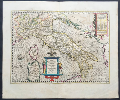
1639 Jodocus Hondius Large Antique Map of Italy Sardinia & Corsica
- Title : Italia
- Date : 1639
- Condition: (A+) Fine Condition
- Ref: 43165
- Size: 22 1/2in x 20in (570mm x 500mm)
Description:
This finely engraved beautifully hand coloured original antique map of Italy was published in the 1639 French edition of Henricus Hondius & Jan Jansson Atlas Nouvs, after Phillip Cluver.
General Description:
Paper thickness and quality: - Heavy and stable
Paper color: - off white
Age of map color: - Original
Colors used: - Green, pink, yellow, blue
General color appearance: - Authentic
Paper size: - 22 1/2in x 20in (570mm x 500mm)
Plate size: - 20in x 14 1/2in (535mm x 365mm)
Margins: - Min 1in (25mm)
Imperfections:
Margins: - Light toning on margin edges
Plate area: - Light offsetting
Verso: - None
Background:
Since classical times the countries bordering the enclosed waters of the Mediterranean had been well versed in the use of maps and sea charts and in Italy, more than anywhere else, the traditional knowledge was kept alive during the many hundreds of years following the collapse of the Roman Empire. By the thirteenth and fourteenth centuries the seamen of Venice, Genoa and Amalfi traded to far countries, from the Black Sea ports and the coasts of Palestine and Egypt in the East to Flanders and the southern coasts of England and Ireland in the West, their voyages guided by portulan charts and the use of the newly invented compass. For a time Italian supremacy in cartography passed to Aragon and the Catalan map makers based on Majorca, but by the year 1400 the power and wealth of the city states of Venice, Genoa, Florence and Milan surpassed any in Europe. Florence, especially, under the rule of the Medici family, became not only a great trading and financial centre but also the focal point of the rediscovery of the arts and learning of the ancient world. In this milieu a number of manuscript world maps were produced, of which one by Fra Mauro (c. 1459) is the most notable, but the event of the greatest importance in the history of cartography occurred in the year 1400 when a Florentine, Palla Strozzi, brought from Constantinople a Greek manuscript copy of Claudius Ptolemy's Geographia, which, 1,250 years after its compilation, came as a revelation to scholars in Western Europe. In the following fifty years or so manuscript copies, translated into Latin and other languages, became available in limited numbers but the invention of movable-type printing transformed the scene: the first copy without maps being printed in 1475 followed by many with copper-engraved maps, at Bologna in 1477, Rome 1478, 1490, 1507 and 1508, and Florence 1482.
About the year 1485 the first book of sea charts, compiled by Bartolommeo dalli Sonetti, was printed in Venice and in the first part of the sixteenth century a number of world maps were published, among them one compiled in 1506 by Giovanni Contarini, engraved by Francesco Rosselli, which was the first printed map to show the discoveries in the New World. In the following years there were many attractive and unusual maps of Islands (Isolano) by Bordone, Camocio and Porcacchi, but more important was the work of Giacomo (Jacopo) Gastaldi, a native of Piedmont who started life as an engineer in the service of the Venetian Republic before turning to cartography as a profession. His maps, produced in great variety and quantity, were beautifully drawn copperplate engravings and his style and techniques were widely copied by his contemporaries. From about 1550 to 1580 many of Gastaldi's maps appeared in the collections of maps known as Lafreri 'atlases', a term applied to groups of maps by different cartographers brought together in one binding. As the contents of such collections varied considerably they were no doubt assembled at the special request of wealthy patrons and are now very rare indeed.
About this time, for a variety of historical and commercial reasons, Italy's position as the leading trading and financial nation rapidly declined and with it her superiority in cartography was lost to the vigorous new states in the Low Countries. That is not to say, of course, that Italian skills as map makers were lost entirely for it was not until 1620 that the first printed maps of Italy by an Italian, Giovanni Magini, appeared, and much later in the century there were fine maps by Giacomo de Rossi and Vincenzo Coronelli, the latter leading a revival of interest in cartography at the end of the century. Coronelli was also famous for the construction of magnificent large-size globes and for the foundation in Venice in 1680 of the first geographical society.
In the eighteenth century the best-known names are Antonio Zatta, Rizzi-Zannoni and Giovanni Cassini.
We ought to mention the work of Baptista Boazio who drew a series of maps in A Summarie and True Discourse of Sir Francis Drake's West Indian Voyage, published in 1588-89, and who is especially noted for a very fine map of Ireland printed in 1599 which was incorporated in the later editions of the Ortelius atlases. It is perhaps appropriate also to refer to two English map makers who spent many years in exile in Italy: the first, George Lily, famous for the splendid map of the British Isles issued in Rome in 1546, and the second, Robert Dudley, who exactly one hundred years later was responsible for the finest sea atlas of the day, Dell' Arcano del Mare,published in Florence. Both of these are described in greater detail elsewhere in this handbook. (Ref: Tooley, Koeman)
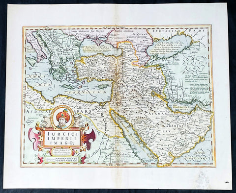
1628 Henricus Hondius Antique Map Ottoman Empire Saudi Arabia to Southern Europe
Antique Map
- Title : Turcici Imperii Imago
- Date : 1628
- Size: 22 1/2in x 18 1/2in (570mm x 470mm)
- Condition: (A-) Good Condition
- Ref: 35642
Description:
This beautifully engraved hand coloured original antique map of The Ottoman Empire in the mid 17th century from Saudi Arabia to southern Europe was published in the 1628 French edition of Mercator's atlas by Jan Jansson and Henricus Hondius.
These maps, published in the later editions of Mercators atlas, are derived from the original maps drawn and engraved by Gerald Mercator in the mid to late 16th century, published by his son Rumold as an atlas, after his death, in 1595. After two editions the plates were purchased by Jodocus Hondius in 1604 and continued to be published until the mid 1630's when the plates were re-engraved and updated by Jan Jansson and Henricus Hondius.
General Definitions:
Paper thickness and quality: - Heavy and stable
Paper color : - off white
Age of map color: - Original & later
Colors used: - Yellow, green, pink
General color appearance: - Authentic
Paper size: - 22 3/4in x 19 3/4in (580mm x 500mm)
Plate size: - 20in x 13 3/4in (500mm x 350mm)
Margins: - Min 1in (25mm)
Imperfections:
Margins: - Light soiling, small wormhole, light creasing
Plate area: - Small loss and creasing along centerfold
Verso: - Light soiling and creasing
Background:
The Ottoman Empire also historically known in Western Europe as the Turkish Empire or simply Turkey, was a state that controlled much of Southeast Europe, Western Asia and North Africa between the 14th and early 20th centuries. It was founded at the end of the 13th century in northwestern Anatolia in the town of Söğüt (modern-day Bilecik Province) by the Oghuz Turkish tribal leader Osman I. After 1354, the Ottomans crossed into Europe, and with the conquest of the Balkans, the Ottoman beylik was transformed into a transcontinental empire. The Ottomans ended the Byzantine Empire with the 1453 conquest of Constantinople by Mehmed the Conqueror.
During the 16th and 17th centuries, at the height of its power under the reign of Suleiman the Magnificent, the Ottoman Empire was a multinational, multilingual empire controlling most of Southeast Europe, parts of Central Europe, Western Asia, parts of Eastern Europe and the Caucasus, North Africa and the Horn of Africa. At the beginning of the 17th century, the empire contained 32 provinces and numerous vassal states. Some of these were later absorbed into the Ottoman Empire, while others were granted various types of autonomy during the course of centuries.
With Constantinople as its capital and control of lands around the Mediterranean basin, the Ottoman Empire was at the centre of interactions between the Eastern and Western worlds for six centuries. While the empire was once thought to have entered a period of decline following the death of Suleiman the Magnificent, this view is no longer supported by the majority of academic historians. The empire continued to maintain a flexible and strong economy, society and military throughout the 17th and much of the 18th century. However, during a long period of peace from 1740 to 1768, the Ottoman military system fell behind that of their European rivals, the Habsburg and Russian empires. The Ottomans consequently suffered severe military defeats in the late 18th and early 19th centuries, which prompted them to initiate a comprehensive process of reform and modernisation known as the Tanzimat. Thus, over the course of the 19th century, the Ottoman state became vastly more powerful and organised, despite suffering further territorial losses, especially in the Balkans, where a number of new states emerged. The empire allied with Germany in the early 20th century, hoping to escape from the diplomatic isolation which had contributed to its recent territorial losses, and thus joined World War I on the side of the Central Powers. While the Empire was able to largely hold its own during the conflict, it was struggling with internal dissent, especially with the Arab Revolt in its Arabian holdings. During this time, atrocities were committed by the Ottoman government against the Armenians, Assyrians and Pontic Greeks.
The Empire\'s defeat and the occupation of part of its territory by the Allied Powers in the aftermath of World War I resulted in its partitioning and the loss of its Middle Eastern territories, which were divided between the United Kingdom and France. The successful Turkish War of Independence against the occupying Allies led to the emergence of the Republic of Turkey in the Anatolian heartland and the abolition of the Ottoman monarchy.
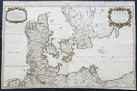
1674 Alexis Jaillot Large Original Antique Map of Denmark & Southern Sweden
- Title : Le Royaume De Danemark....1674...Hubert Jaillot
- Size: 35in x 23 1/2in (890mm x 595mm)
- Condition: (A) Very Good Condition
- Date : 1674
- Ref #: 43172
Description:
This very large, beautifully hand coloured original antique map of Denmark & Southern Sweden by Alexis Hubert Jaillot - after Nicolas Sanson - was engraved in 1674 - the date is engraved in the scale cartouche and as published by Jaillot in his large Imperial Elephant Folio Atlas.
This is a beautiful Jaillot map, fantastic colour, clean and heavy paper and a deep clear impression, signifying an early pressing.
General Definitions:
Paper thickness and quality: - Heavy and stable
Paper color : - off white
Age of map color: - Original & later
Colors used: - Yellow, green, blue, pink
General color appearance: - Authentic
Paper size: - 35in x 23 1/2in (890mm x 595mm)
Plate size: - 35in x 23 1/2in (890mm x 595mm)
Margins: - Min 0in (0mm)
Imperfections:
Margins: - Top & bottom margins cropped to border
Plate area: - Folds as issued
Verso: - Folds as issued
Background:
Before the fifteenth century the people of Southern Europe had little geographical knowledge of the Scandinavian World except from sketchy detail shown in the Catalan Atlas (1375) and on a number of " portolani" embracing Denmark and the southern tip of Norway. It was not until 1427 that a manuscript map prepared about that time by Claudius Clavus (b.1388) a Dane who spent some time in Rome, made available to scholars a tolerable outline of the northern countries and Greenland. That was to remain the best map available for the rest of the century and it was used as the basis for maps of Scandinavia in early printed editions of Ptolemy. Others by Nicolaus Cusanus (1491) and Ehrhard Etzlaub (c. 1492) followed but, needless to say, these are extremely rare; even the later maps by Olaus Magnus and Marcus Jordan, where they have survived at all , are known only by a very few examples. In fact, apart from the rare appearance of an early Ptolemy map, the oldest of Scandinavia which a collector is likely to find are those of Munster's Cosmograhy first published in 1544. In the following centuries the few maps and charts complied in Scandinavia were usually published in Amsterdam, Antwerp, Paris or Nuremberg, the most important maps often being incorporated in the major Dutch, French & German Atlases. (Ref: Tooley; M&B)
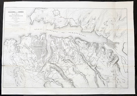
1856 Delafield Large Antique Lithograph Map Siege of Sevastopol Crimea, 1854-55
- Title : Sebastopol and ts Environs showing the Russian Defences and the Approaches and other Works of Attack of the Allied Armies during the Seige of 1854-55 from the Report of Gen. Niel Chief of the French Eng. prepared to accompany the report of Major Delafield on the art of War in Europe in 1854, 55 & 56
- Date : 1856
- Condition: (A) Very Good Condition
- Ref: 90124
- Size: 41in x 29in (1.040m x 735mm)
Description:
This large, scarce, original lithograph antique map of the defences of the city of Sevastopol, on the Crimean Peninsula on the Black Sea, during the Crimean War and the siege of Sevastopol in 1854-55, was published by the American Army Officer Major Richard Delafield in his 1856 report to the Secretary of War, Jefferson Davis, Report on the Art of War in Europe in 1854, 1855, and 1856 The lithography was completed by Bowen & Co of Philadelphia. Very rare map in VG condition.
An amazing very large lithograph map, highly detailed, illustrating the Russian defences of the city of Sevastopol and the attack position of the British, French & Turkish attacking positions.
General Definitions:
Paper thickness and quality: - Heavy and stable
Paper color : - off white
Age of map color: -
Colors used: -
General color appearance: -
Paper size: - 41in x 29in (1.040m x 735mm)
Plate size: - 41in x 29in (1.040m x 735mm)
Margins: - Min 1/2in (12mm)
Imperfections:
Margins: - None
Plate area: - Small repair along left fold, folds as issued
Verso: - Several folds re-enforced with archival tape
Background:
Siege of Sevastopol (1854–1855)
The siege of Sevastopol (at the time the siege of Sebastopol) lasted from October 1854 until September 1855, during the Crimean War. The allies (French, Ottoman, and British) landed at Eupatoria on 14 September 1854, intending to make a triumphal march to Sevastopol, the capital of the Crimea, with 50,000 men. The 56-kilometre traverse took a year of fighting against the Russians. Major battles along the way were Alma (September 1854), Balaklava (October 1854), Inkerman (November 1854), Tchernaya (August 1855), Redan (September 1855), and, finally, Sevastopol (September 1855). During the siege, the allied navy undertook six bombardments of the capital, on 17 October 1854; and on 9 April, 6 June, 17 June, 17 August, and 5 September 1855.
Sevastopol is one of the classic sieges of all time. The city of Sevastopol was the home of the Tsardefencess Black Sea Fleet, which threatened the Mediterranean. The Russian field army withdrew before the allies could encircle it. The siege was the culminating struggle for the strategic Russian port in 1854–55 and was the final episode in the Crimean War.
During the Victorian Era, these battles were repeatedly memorialized. The siege of Sevastopol was the subject of Crimean soldier Leo Tolstoydefencess Sebastopol Sketches and the subject of the first Russian feature film, Defence of Sevastopol. The Battle of Balaklava was made famous by Alfred, Lord Tennysondefencess poem defencesThe Charge of the Light Brigadedefences and Robert Gibbdefencess painting The Thin Red Line. A panorama of the siege itself was painted by Franz Roubaud.
Delafield, Richard Major General 1798 - 1873
Delafield was a United States Army officer for 52 years. He served as superintendent of the United States Military Academy for 12 years. At the start of the American Civil War, then Colonel Delafield helped equip and send volunteers from New York to the Union Army. He also was in command of defences around New York harbor from 1861 to April 1864. On April 22, 1864, he was promoted to Brigadier General in the Regular Army of the United States and Chief of Engineers. On March 8, 1866, President Andrew Johnson nominated Delafield for appointment to the grade of brevet major general in the Regular Army, to rank from March 13, 1865, and the United States Senate confirmed the appointment on May 4, 1866, reconfirmed due to a technicality on July 14, 1866. He retired from the US Army on August 8, 1866. He later served on two commissions relating to improvements to Boston Harbor and to lighthouses. He also served as a regent of the Smithsonian Institution.
Delafield served as assistant engineer in the construction of Hampton Roads defences from 1819–1824 and was in charge of fortifications and surveys in the Mississippi River delta area in 1824-1832. While superintendent of repair work on the Cumberland Road east of the Ohio River, he designed and built Dunlaps Creek Bridge in Brownsville, Pennsylvania, the first cast-iron tubular-arch bridge in the United States. Commissioned a major of engineers in July 1838, he was appointed superintendent of the Military Academy after the fire of 1838 and served till 1845. He designed the new buildings and the new cadet uniform that first displayed the castle insignia. He superintended the construction of coast defences for New York Harbor from 1846 to 1855.
In the beginning of 1855, Delafield was appointed by the Secretary of War, Jefferson Davis a head of the board of officers, later called The Delafield Commission, and sent to Europe to study the European military. The board included Captain George B. McClellan and Major Alfred Mordecai. They inspected the state of the military in Great Britain, Germany, the Austrian Empire, France, Belgium, and Russia, and served as military observers during the Crimean War. After his return in April 1856, Delafield submitted a report which was later published as a book by Congress, Report on the Art of War in Europe in 1854, 1855, and 1856. The book was suppressed during the American Civil War due to fears that it would be instructive to Confederate engineers as it contained multiple drawings and descriptions of military fortifications.
Delafield served as superintendent of the Military Academy again in 1856-1861. In January 1861, he was succeeded by Captain Pierre G. T. Beauregard, who was dismissed shortly after Beauregards home state of Louisiana seceded from the Union, and Delafield returned as superintendent serving until March 1, 1861. In the beginning of the Civil War he advised the governor of New York Edwin D. Morgan during the volunteer force creation. Then, in 1861–1864, he was put in charge of New York Harbor defences, including Governors Island and Fort at Sandy Hook. On May 19, 1864, he was commissioned a brigadier-general after replacing Joseph Gilbert Totten, who had died, as the Chief of Engineers, United States Army Corps of Engineers, on April 22, 1864. He stayed in charge of the Bureau of Engineers of the War Department until his retirement on August 8, 1866. On March 8, 1866, President Andrew Johnson nominated Delafield for appointment to the grade of brevet major general in the Regular Army of the United States, to rank from March 13, 1865, and the United States Senate confirmed the appointment on May 4, 1866 and reconfirmed it due to a technicality on July 14, 1866.After retirement Delafield served as a regent of the Smithsonian Institution and a member of the Lighthouse Board. He died in Washington, D.C. on November 5, 1873.
The Jamaican and English nurses who treated the wounded during these battles were much celebrated, most famously Mary Seacole and Florence Nightingale.
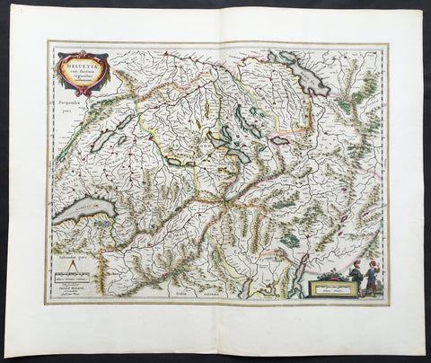
1647 Willem Blaeu Large Antique Map of Switzerland - Helvetia
- Title : Helvetia cum sinitimis regionibus confoederatis
- Ref #: 61109
- Size: 24in x 20in (610mm x 510mm)
- Date : 1647
- Condition: (A+) Fine Condition
Description:
This fine, beautifully hand coloured original antique map* of Switzerland by Willem Blaeu was published in the 1647 Dutch edition of Atlas Novus.
This map, engraved by Blaeu but attributed to Gerard Mercator, is in fine condition with fine original margins, clean stable paper and original colour. A beautiful example of this map by Blaeu after Mercator.
General Description:
Paper thickness and quality: - Heavy and stable
Paper color: - off white
Age of map color: - Original
Colors used: - Yellow, pink, red, blue, green
General color appearance: - Authentic
Paper size: - 24in x 20in (610mm x 510mm)
Plate size: - 20in x 15 1/4in (510mm x 390mm)
Margins: - Min 2in (50mm)
Imperfections:
Margins: - None
Plate area: - None
Verso: - None
Background: The first printed map of Switzerland was published in Martin Waldseemuller's edition of Ptolemy in Strasbourg in 1513, but the manuscript map by Konrad Turst (1497) drawn to scale was a splendid first achievement for its time. Also the research of Vadianus at St Gallen University produced notable work, and along with the Germanic influence in Basle, which became part of the Swiss Confederation in 1501, and the highly developed wood engraving skills there, were important factors in European map publishing.
The almost endless editions of Sebastian Munster's Cosmographia were published in Basle from 1540 for nearly a century and Zurich can claim to have published the first national atlas produced anywhere -that of Johann Stumpf in 1548-52.
By comparison with her larger neighbours, Germany and Italy, Switzerland is considered not to have made a major contribution to Cartographic history. But over the years this has been contradicted, especially starting in the sixteenth century. In the second half of the sixteenth century many maps of the Swiss Cantons, in manuscript or woodcuts appeared, but the mountainous nature of the country produced its own mapping problems and imposed a need for large-scale surveys as well as practical and effective methods of showing land surfaces in relief. Early in the seventeenth century Hans Gyger perfected new ways of doing this but although he published a wide range of very large-scale maps of the cantons and of Switzerland as a whole his techniques did not receive the credit they deserved. On the other hand, his countrymen followed his example of compiling large-scale maps for which they have always been noted for up until the present day. (Ref: Koeman; M&B)
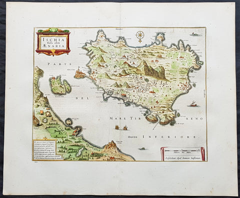
1652 Jansson Large Antique Map Islands of Ischia, Procida & Vivara Naples, Italy
- Title : Ischia Isola olim Aenaria
- Date : 1652
- Size: 24in x 20in (610mm x 510mm)
- Ref #: 61155
- Condition: (A+) Fine Condition
Description:
This large fine & beautifully hand coloured original antique map of the Italian Islands of Ischia, Procida & Vivara in the the Gulf of Naples in Southern Italy was published in the 1652 French edition of Jan Jansson's Atlas Novus.
Background: Ischia is a volcanic island in the Tyrrhenian Sea, lying at the northern end of the Gulf of Naples, about 30 kilometres from the city of Naples. It is the largest of the Phlegrean Islands.
In 6 AD, Augustus restored the island to Naples in exchange for Capri. Ischia suffered from the barbarian invasions, being taken first by the Heruli then by the Ostrogoths, being ultimately absorbed into the Eastern Roman Empire. The Byzantines gave the island over to Naples in 588 and by 661 it was being administered by a Count liege to the Duke of Naples. The area was devastated by the Saracens in 813 and 847; in 1004 it was occupied by Henry II of Germany; the Norman Roger II of Sicily took it in 1130 granting the island to the Norman Aldoyn de Candida created Count d’Ischia; the island was raided by the Pisans in 1135 and 1137 and subsequently fell under the Suebi and then Angevin rule. After the Sicilian Vespers in 1282, the island rebelled, recognizing Peter III of Aragon, but was retaken by the Angevins the following year. It was conquered in 1284 by the forces of Aragon and Charles II of Anjou was unable to successfully retake it until 1299.
As a consequence of the island's last eruption, the population fled to Baia where they remained for 4 years. In 1320 Robert of Anjou and his wife Sancia visited the island and were hosted by Cesare Sterlich, who had been sent by Charles II from the Holy See to govern the island in 1306 and was by this time nearly 100 years of age.
Ischia suffered greatly in the struggles between the Angevin and Durazzo dynasties. It was taken by Carlo Durazzo in 1382, retaken by Louis II of Anjou in 1385 and captured yet again by Ladislaus of Naples in 1386; it was sacked by the fleet of the Antipope John XXIII under the command of Gaspare Cossa in 1410 only to be retaken by Ladislaus the following year. In 1422 Joan II gave the island to her adoptive son Alfonso V of Aragon, though, when he fell into disgrace, she retook it with the help of Genoa in 1424. In 1438 Alfonso reoccupied the castle, kicking out all the men and proclaiming it an Aragonese colony, marrying to his garrison the wives and daughters of the expelled. He set about building a bridge linking the castle to the rest of the island and he carved out a large gallery, both of which are still to be seen today. In 1442, he gave the island to one of his favorites, Lucretia d'Alagno, who in turn entrusted the island's governance to her brother-in-law, Giovanni Torella. Upon the death of Alfonso in 1458, they returned the island to the Angevin side. Ferdinand I of Naples ordered Alessandro Sforza to chase Torella out of the castle and gave the island over, in 1462, to Garceraldo Requesens. In 1464, after a brief Torellan insurrection, Marino Caracciolo was set up as governor.
In February 1495, with the arrival of Charles VIII, Ferdinand II landed on the island and took possession of the castle, and, after having killed the disloyal castellan Giusto di Candida with his own hands, left the island under the control of Innico d'Avalos, marquis of Pescara and Vasto, who ably defended the place from the French flotilla. With him came his sister Costanza and through them they founded the D'Avalos dynasty which would last on the island into the 18th century.
Throughout the 16th century, the island suffered the incursions of pirates and Barbary privateers from North Africa - in 1543 and 1544 Hayreddin Barbarossa laid waste to the island, taking 4,000 prisoners in the process. In 1548 and 1552, Ischia was beset by his successor Dragut Rais. With the increasing rarity and diminishing severity of the piratical attacks later in the century and the construction of better defenses, the islanders began to venture out of the castle and it was then that the historic centre of the town of Ischia was begun. Even so, many inhabitants still ended up slaves to the pirates, the last known being taken in 1796. During the 1647 revolution of Masaniello, there was an attempted rebellion against the feudal landowners. (Ref: Koeman; M&B)
Condition Report:
Paper thickness and quality: - Heavy and stable
Paper color: - off white
Age of map color: - Original
Colors used: - Yellow, pink, green
General color appearance: - Authentic
Paper size: - 24in x 20in (610mm x 510mm)
Plate size: - 18in x 14in (460mm x 355mm)
Margins: - Min 2in (50mm)
Imperfections:
Margins: - None
Plate area: - None
Verso: - None
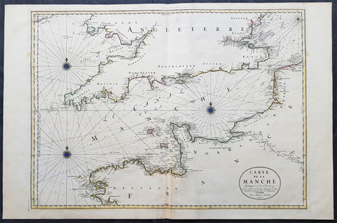
1692 Jaillot Large Antique Map Sea Chart The English Channel during 9 Years War
- Title : Carte De La Manche faite par ordre du Roy. pour le Service de les Armees de Mer.....a Paris...1692
- Size: 38in x 25in (960m x 635mm)
- Condition: (A+) Fine Condition
- Date : 1692
- Ref #: 16371
Description:
This very large, beautifully hand coloured original copper-plate engraved antique map, a large Sea Chart of The English Channel - produced for the French Navy during the Nine Years War and specifically the Battle of Beachy Head - was engraved in 1692, dated in the cartouche, and was published for Alexis Hubert Jaillots 1698 edition of his monumental Atlas Nouveau.
General Definitions:
Paper thickness and quality: - Heavy and stable
Paper color : - off white
Age of map color: - Original
Colors used: - Yellow, pink, green, blue
General color appearance: - Authentic
Paper size: - 38in x 25in (960m x 635mm)
Plate size: - 32 1/2in x 23 1/2in (825mm x 595mm)
Margins: - Min 1in (25mm)
Imperfections:
Margins: - None
Plate area: - None
Verso: - None
Background:
The Nine Years War (1688–97)—often called the War of the Grand Alliance or the War of the League of Augsburg—was a conflict between Louis XIV of France and a European coalition of the Holy Roman Empire, led by Austria, the Dutch Republic, Spain, England and Savoy. It was fought in Europe and the surrounding seas, North America and in India. It is sometimes considered the first global war. The conflict encompassed the Williamite war in Ireland and Jacobite risings in Scotland, where William III and James II struggled for control of England and Ireland, and a campaign in colonial North America between French and English settlers and their respective Indigenous allies, today called King Williams War by Americans.
Louis XIV of France had emerged from the Franco-Dutch War in 1678 as the most powerful monarch in Europe, an absolute ruler who had won numerous military victories. Using a combination of aggression, annexation, and quasi-legal means, Louis XIV set about extending his gains to stabilize and strengthen France\'s frontiers, culminating in the brief War of the Reunions (1683–84). The Truce of Ratisbon guaranteed France\'s new borders for twenty years, but Louis XIV\'s subsequent actions—notably his Edict of Fontainebleau (the revocation of the Edict of Nantes) in 1685— led to the deterioration of his military and political dominance. Louis XIVs decision to cross the Rhine in September 1688 was designed to extend his influence and pressure the Holy Roman Empire into accepting his territorial and dynastic claims. Leopold I and the German princes resolved to resist, and when the States General and William III brought the Dutch and the English into the war against France, the French King faced a powerful coalition aimed at curtailing his ambitions.
The main fighting took place around Frances borders in the Spanish Netherlands, the Rhineland, the Duchy of Savoy and Catalonia. The fighting generally favoured Louis XIV\'s armies, but by 1696 his country was in the grip of an economic crisis. The Maritime Powers (England and the Dutch Republic) were also financially exhausted, and when Savoy defected from the Alliance, all parties were keen to negotiate a settlement. By the terms of the Treaty of Ryswick (1697) Louis XIV retained the whole of Alsace but was forced to return Lorraine to its ruler and give up any gains on the right bank of the Rhine. Louis XIV also accepted William III as the rightful King of England, while the Dutch acquired a Barrier fortress system in the Spanish Netherlands to help secure their borders. With the ailing and childless Charles II of Spain approaching his end, a new conflict over the inheritance of the Spanish Empire embroiled Louis XIV and the Grand Alliance in the War of the Spanish Succession.
The Battle of Beachy Head (Bévéziers) was a naval engagement fought on 10 July 1690 during the Nine Years\' War. The battle was the greatest French tactical naval victory over their English and Dutch opponents during the war. The Dutch lost six ships of the line (sources vary) and three fireships; their English allies also lost one ship of the line, whereas the French did not lose a vessel. Control of the English Channel temporarily fell into French hands but Vice-Admiral Tourville failed to pursue the Allied fleet with sufficient vigour, allowing it to escape to the River Thames.
Tourville was criticised for not following up his victory and was relieved of his command. The English Admiral Arthur Herbert, 1st Earl of Torrington – who had advised against engaging the superior French fleet but had been overruled by Queen Mary and her ministers – was court-martialled for his performance during the battle. Although he was acquitted, King William dismissed him from the service.
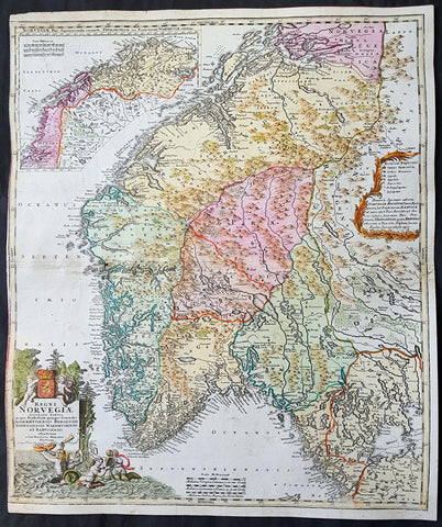
1720 J B Homann Large Original Antique Map of Norway - Regni Norvegiae
- Title : Regni Norvegiae Accurata Tabula in qua Praefecturae Quinque Generales Aggerhusiensis, Bergensis Nidrosiensis, Wardhusiensis et Bahusiensi Ioh. Bapt. Homanno.
- Date : 1720
- Condition: (A) Very Good Condition
- Ref: 16424
- Size: 24in x 20 1/4in (610mm x 515mm)
Description: This large beautifully hand coloured original antique map of Norway & parts of Scandinavia - with an inset map of Lapland & Northern Norway - was published by Johann Baptist Homann in 1720.
Background: Before the fifteenth century the peoples of Southern Europe had little geographical knowledge of the Scandinavian world except from sketchy detail shown in the Catalan Atlas (1375) and on a number of 'portolani' embracing Denmark and the southern tip of Norway. It was not until 1427 that a manuscript map prepared about that time by Claudius Clavus (b. 1388), a Dane who had spent some time in Rome, made available to scholars a tolerable outline of the northern countries and Greenland. That was to remain the best map available for the rest of the century and it was used as the basis for maps of Scandinavia in early printed editions of Ptolemy. Others by Nicolaus Cusanus (1491) and Ehrhard Etzlaub (c. 1492) followed but, needless to say, these are extremely rare; even the later maps by Olaus Magnus and Marcus Jordan, where they have survived at all, are known only by very few examples. In fact, apart from the rare appearance of an early Ptolemy map, the oldest of Scandinavia which a collector is likely to find are those in Munster's Cosmography published in 1544 with many later editions. In the following centuries the comparatively few maps and charts compiled in Scandinavia were usually published in Amsterdam, Antwerp, Paris or Nuremberg, the more important maps often being incorporated in the major Dutch, French and German atlases. (Ref: Tooley; M&B)
Condition Report:
Paper thickness and quality: - Heavy and stable
Paper color: - Off white
Age of map color: - Original & later
Colors used: - Yellow, pink, green
General color appearance: - Authentic
Paper size: - 24in x 20 1/4in (610mm x 515mm)
Plate size: - 23 1/2in x 20in (595mm x 505mm)
Margins: - Min 1/8in (2mm)
Imperfections:
Margins: - Left margin cropped to plate-mark
Plate area: - Light creasing
Verso: - Centerfold re-joined, small re-enforced adjacent to centerfold
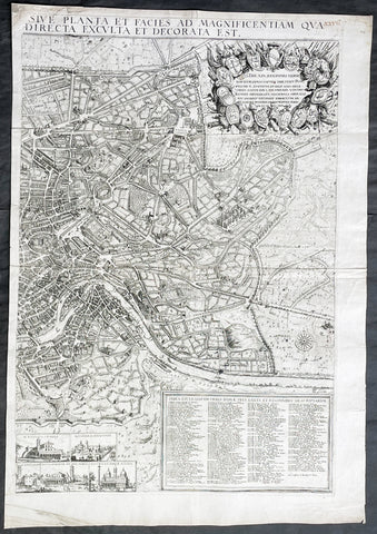
1679 Jacob von Sandrart & Giovanni Battista Falda Large Left Hand Sheet of Rome
- Title : Recentis Romae Ichnographia et Hypsographia Sive Planta et Faies Ad Magnificentiam Qua Prioribus Annis Urbs Ipsa Directa Exculta et Decorata Est.
- Date : 1679
- Size: 26 3/4in x 18 3/4in (680mm x 475mm)
- Condition: (A+) Fine Condition
- Ref: 43188
Description:
This large, original copper plate engraved scarce left hand section of the map of Rome by Jacob Von Sandrart, after Giovanni Battista Falda map, was published in 1679.
This map is based on Giovanni Battista Falda's 12-sheet view of Rome, Nuova Pianta et alzata della citta di Roma, first published in 1676.
Sandrart's view of Rome is rare, we are aware of only 2 examples appearing at auction during the last 25 years.
General Definitions:
Paper thickness and quality: - Heavy and stable
Paper color : - off white
Age of map color: -
Colors used: -
General color appearance: -
Paper size: - 26 3/4in x 18 3/4in (680mm x 475mm)
Plate size: - 25in x 17in (635mm x 430mm)
Margins: - Min 1/2in (12mm)
Imperfections:
Margins: - None
Plate area: - Light creasing along centerfold
Verso: - None
Background:
Jacob von Sandrart's rare and exquisitely engraved view of Rome, one of the finest impressions of the 'Eternal City' made during the great Baroque Era of Art and Architecture.
This finely engraved and lavishly decorative view of Rome takes in all of the 'Eternal City', as it was encompassed by its ancient Aurelian Walls, built during the 2nd Century A.D., on the banks of the River Tiber. Numerous monuments and sites, all of which are still present today, can be seem on the view, including the Coliseum, the Pantheon, the Piazza del Popolo, the Church of San Giovanni Laterno, the Baths of Diocletian, and the Vatican, which is dominated by the Dome of St. Peter's Basilica and the Castel Sant'Angelo. Most notable is the great oval Colonnade that lines the square in front of St. Peter's, which had only been completed in 1666 by the Gianlorenzo Bernini, one of the towering figures of the Baroque Era. The quality of the engraving is exceptionally high, as is the composition of the view, which grants the observer a panoptic view over Rome, while the specific details of the cityscape remain sharply distinguishable.
In the upper left, the title cartouche is surmounted by a portrait of Pope Innocent XI (reigned 1676-89), considered to be a leader of great learning and political acumen. In the upper right corner is a montage featuring the shields of the 14 traditional districts (wards) of Rome. Flowing through the view itself, the River Tiber has its orgins in an allegorical personification of its springs.
In the lower left, a table, 'Index Aedium Antiquitatarum' identifies an amazing 253 ancient buildings and ruins throughout the city. The 'Index Ecclesiarium' in the lower right identifies an incredible 178 churches, although it is not surprising that Rome had by far more houses of worship than any other city in Europe.
In the lower center of the plan are seven views of some of the city's most prominent churches, including St. Peter's Basilica (Vatican), St. Paul's Basilica, San Sebastian Church, San Giovanni Laterno, Sacred Cross of Jerusalem Church, Basilica of St. Lawrence Outside the Walls and the Basilica of Santa Maria Maggiore.
At the time that this view was issued, Rome was enjoying a period of prosperity, and the city's population had reached over 120,000, making it one of the 10 largest cities in Europe. The Roman Catholic Church was on a high, having largely succeeded in driving the Counterreformation, and revenues were pouring in to the Vatican from around the world. This funded the great flourishing of art and architecture in Baroque Rome.
The map was engraved by Jacob von Sandrart (1630-1708), one of the leading fine art engravers of the 17th Century. Born in Frankfurt-am-Main, he apprenticed under his famous uncle Joachim von Sandrart in Amsterdam. He worked in Danzing and Regensburg, and by 1656 had established himself in Nuremberg, where he remained for the rest of his life. Sandrart was highly productive, as over 400 different engravings from his burin are known to survive, although the high quality of his work never wavered. Along with his maps, he is especially well-known for his portraits. Sandrart was the founder and first director of the Nuremberg Academy of Fine Arts (chartered 1662).
Sandrart, Jacob von 1630 - 1708
Jacob von Sandrart was a German engraver primarily active in Nuremberg.
At age ten Sandrart obtained his artistic training from his better-known uncle Joachim von Sandrart in Amsterdam. After spending time in Danzig and Regensburg, he married Regina Christina Eimart, daughter of the engraver Georg Christoph Eimart the elder, on 10 June 1654. The couple settled in Nuremberg in 1656 and remained there for the rest of their lives. His daughter Susanne Maria von Sandrart was also an artist and engraver.
Sandrart was a very prolific artist; over 400 engravings from his hand are extant. He was best known as a portraitist of prominent contemporary citizens of Nuremberg, as an engraver of maps, and as an illustrator of the literary works of Nuremberg writers, especially Sigmund von Birken. Today Sandrart is best remembered as the founder and first director of the Nuremberg Academy of Fine Arts (est. 1662).
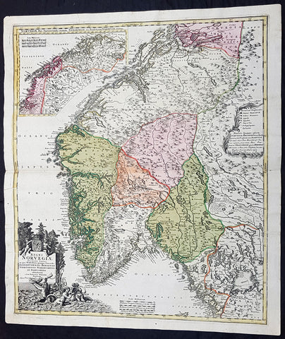
1720 J B Homann Large Original Antique Map of Norway - Regni Norvegiae
- Title : Regni Norvegiae Accurata Tabula in qua Praefecturae Quinque Generales Aggerhusiensis, Bergensis Nidrosiensis, Wardhusiensis et Bahusiensi Ioh. Bapt. Homanno.
- Date : 1720
- Condition: (A+) Fine Condition
- Ref: 93359
- Size: 24in x 20 1/4in (610mm x 540mm)
Description: This large beautifully hand coloured original antique map of Norway & parts of Scandinavia - with an inset map of Lapland & Northern Norway - was published by Johann Baptist Homann in 1720.
Condition Report:
Paper thickness and quality: - Heavy and stable
Paper color: - Off white
Age of map color: - Original
Colors used: - Yellow, pink, green
General color appearance: - Authentic
Paper size: - 24in x 20 1/4in (610mm x 540mm)
Plate size: - 23 1/2in x 20in (595mm x 505mm)
Margins: - Min 1/2in (12mm)
Imperfections:
Margins: - None
Plate area: - None
Verso: - None
Background: Before the fifteenth century the peoples of Southern Europe had little geographical knowledge of the Scandinavian world except from sketchy detail shown in the Catalan Atlas (1375) and on a number of 'portolani' embracing Denmark and the southern tip of Norway. It was not until 1427 that a manuscript map prepared about that time by Claudius Clavus (b. 1388), a Dane who had spent some time in Rome, made available to scholars a tolerable outline of the northern countries and Greenland. That was to remain the best map available for the rest of the century and it was used as the basis for maps of Scandinavia in early printed editions of Ptolemy. Others by Nicolaus Cusanus (1491) and Ehrhard Etzlaub (c. 1492) followed but, needless to say, these are extremely rare; even the later maps by Olaus Magnus and Marcus Jordan, where they have survived at all, are known only by very few examples. In fact, apart from the rare appearance of an early Ptolemy map, the oldest of Scandinavia which a collector is likely to find are those in Munster's Cosmography published in 1544 with many later editions. In the following centuries the comparatively few maps and charts compiled in Scandinavia were usually published in Amsterdam, Antwerp, Paris or Nuremberg, the more important maps often being incorporated in the major Dutch, French and German atlases. (Ref: Tooley; M&B)
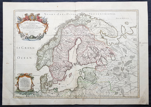
1707 Alexis Jaillot Large Original Antique Map of Scandinavia, Estonia, Latvia..
- Title : La Scandinavie...Hubert Jaillot 1707
- Ref #: 50665
- Size: 29 1/2in x 21in (750mm x 535mm)
- Date : 1707
- Condition: (B) Good Condition
Description:
This large beautifully hand coloured original antique map of Scandinavia, Norway, Sweden, Finland, Denmark, Latvia & Estonia, was engraved by Robert Cordier - after Nicolas Sanson - in 1707 - the date is engraved in the title and published by Alexis Jaillot.
General Definitions:
Paper thickness and quality: - Heavy and stable
Paper color : - off white
Age of map color: - Original
Colors used: - Yellow, green, blue, pink
General color appearance: - Authentic
Paper size: - 29 1/2in x 21in (750mm x 535mm)
Plate size: - 26in x 18 1/2in (660mm x 470mm)
Margins: - Min 1in (25mm)
Imperfections:
Margins: - Light soiling
Plate area: - Professional repair bottom left of plate, bottom centerfold re-joined and light uplift
Verso: - Professional repairs as noted
Background:
Before the fifteenth century the people of Southern Europe had little geographical knowledge of the Scandinavian World except from sketchy detail shown in the Catalan Atlas (1375) and on a number of " portolani" embracing Denmark and the southern tip of Norway. It was not until 1427 that a manuscript map prepared about that time by Claudius Clavus (b.1388) a Dane who spent some time in Rome, made available to scholars a tolerable outline of the northern countries and Greenland. That was to remain the best map available for the rest of the century and it was used as the basis for maps of Scandinavia in early printed editions of Ptolemy. Others by Nicolaus Cusanus (1491) and Ehrhard Etzlaub (c. 1492) followed but, needless to say, these are extremely rare; even the later maps by Olaus Magnus and Marcus Jordan, where they have survived at all , are known only by a very few examples. In fact, apart from the rare appearance of an early Ptolemy map, the oldest of Scandinavia which a collector is likely to find are those of Munster's Cosmograhy first published in 1544. In the following centuries the few maps and charts complied in Scandinavia were usually published in Amsterdam, Antwerp, Paris or Nuremberg, the most important maps often being incorporated in the major Dutch, French & German Atlases. (Ref: Tooley; M&B)
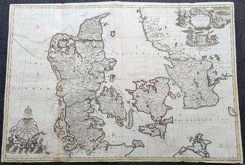
1720 John Senex Large Antique Map of Denmark & Southern Sweden
- Title : Denmark Corrected from the Newest Observations of the Royal Society at London and Paris by John Senex FRS
- Size: 38 1/2in x 27in (965mm x 685mm)
- Condition: (A) Very Good Condition
- Date : 1720
- Ref #: 70706
Description:
This large hand coloured original antique map of Denmark was engraved by John Senex and was published in the 1720 edition of his Elephant Folio Atlas.
This map is in VG condition. These large scale maps are scarce due mainly to their size, with damage and loss over time inevitable.
General Definitions:
Paper thickness and quality: - Heavy and stable
Paper color : - off white
Age of map color: - Original
Colors used: - Yellow, green, blue, pink
General color appearance: - Authentic
Paper size: - 38 1/2in x 27in (965mm x 685mm)
Plate size: - 38in x 26 1/2in (960mm x 680mm)
Margins: - Min 1/4in (6mm)
Imperfections:
Margins: - Chipping to bottom margin
Plate area: - Light offsetting
Verso: - Light creasing
Background:
Before the fifteenth century the people of Southern Europe had little geographical knowledge of the Scandinavian World except from sketchy detail shown in the Catalan Atlas (1375) and on a number of \" portolani\" embracing Denmark and the southern tip of Norway. It was not until 1427 that a manuscript map prepared about that time by Claudius Clavus (b.1388) a Dane who spent some time in Rome, made available to scholars a tolerable outline of the northern countries and Greenland. That was to remain the best map available for the rest of the century and it was used as the basis for maps of Scandinavia in early printed editions of Ptolemy. Others by Nicolaus Cusanus (1491) and Ehrhard Etzlaub (c. 1492) followed but, needless to say, these are extremely rare; even the later maps by Olaus Magnus and Marcus Jordan, where they have survived at all , are known only by a very few examples. In fact, apart from the rare appearance of an early Ptolemy map, the oldest of Scandinavia which a collector is likely to find are those of Munster\'s Cosmograhy first published in 1544. In the following centuries the few maps and charts complied in Scandinavia were usually published in Amsterdam, Antwerp, Paris or Nuremberg, the most important maps often being incorporated in the major Dutch, French & German Atlases. (Ref: Tooley; M&B)
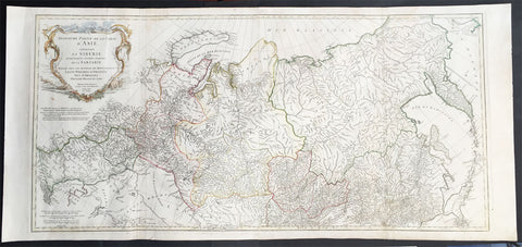
1762 D Anville Very Large Antique Map of Russia, Siberia, Mongolia, China, Japan
- Title : Troisieme Partie De La Carte D' Asia Contenant La Siberie...MDCCLII
- Ref #: 50604
- Size: 55in x 22 1/2in (1.25m x 570mm)
- Date : 1762
- Condition: (A+) Fine Condition
Description:
This very large beautifully engraved hand coloured original antique map of Russia, Siberia and Central Asia was engraved by Jean-Baptiste Bourguinon D'Anville in 1762 - the date is engraved in the title - and was published in the large elephant folio atlas Atlas Generale.
These maps are hard to find in such good condition and make fantastic historical reference tools due to the size and high level of detail as with all D'Anvilles work. (Ref: Tooley, M&B)
General Description:
Paper thickness and quality: - Heavy and stable
Paper color: - White
Age of map color: - Original
Colors used: - Yellow, pink, green
General color appearance: - Authentic
Paper size: - 55in x 22 1/2in (1.25m x 570mm)
Plate size: - 43in x 21in (1.10mm x 535mm)
Margins: - Min 1in (25mm)
Imperfections:
Margins: - None
Plate area: - Light creasing & soiling along L&R folds
Verso: - None

1639 Mercator & Hondius Large Antique Map of Greece, Aegean Islands & Turkey
- Title : Nova Totius Graeciae descriptio
- Date : 1639
- Size: 22in x 18 1/2in (560mm x 470mm)
- Ref #: 43151
- Condition: (A) Very Good Condition
Description:
This fine, beautifully hand coloured original antique map of Greece, Aegean Islands & Turkey was published in the 1639 French edition of Gerardi Mercators Atlantis Novi Atlas by Jan Jansson and Henricus Hondius.
Condition Report:
Paper thickness and quality: - Heavy & stable
Paper color: - off white
Age of map color: - Original
Colors used: - Yellow, pink, green
General color appearance: - Authentic
Paper size: - 22in x 18 1/2in (560mm x 470mm)
Plate size: - 18 1/2in x 14 1/2in (470mm x 350mm)
Margins: - Min 1in (25mm)
Imperfections:
Margins: - Bottom & top margin centre-fold re-joined, no loss
Plate area: - Repair to left side of image, no loss
Verso: - Repairs as noted
Background:
From the early days of map-making, cartographers have always had a keen interest he mapping of Greece and of the particular continental and insular Greek areas. In other words the "Greek chorography", as it is often called had been a cartographic item of special importance, both in manuscript and printed cartography, the later having produced an impressive number of Greek maps. All of these have been include in almost all the European Atlases and travel books, since the first printed edition of Ptolemy's Geographia in 1447. This prominent presence of Greece in the field of European cartography is due to various historic, political and cultural reasons. (Ref: Koeman; M&B)
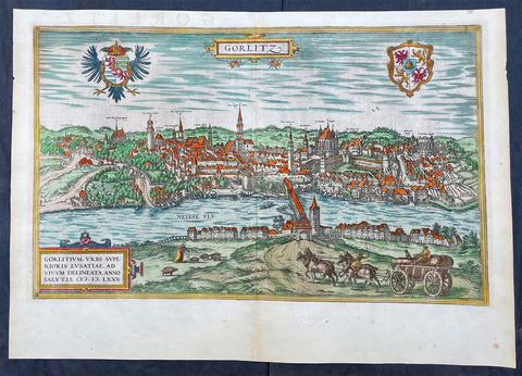
1574 Braun & Hogenberg Antique Map View of Gorlitz-Zgorzelec, Germany & Poland
- Title : Gorlitz
- Ref #: 93432
- Size: 22in x 16 1/2in (560mm x 420mm)
- Date : 1574
- Condition: (A+) Fine Condition
Description:
This original beautifully hand coloured copper plate engraved antique map, a birds eye view of the city of Gorlitz-Zgorzelec, in the state of Saxony, in the region of Lusatia, in far eastern Germany, on the border with Poland, was published in the 1574 edition of Braun & Hogenbergs atlas Civitates Orbis Terrarum
General Definitions:
Paper thickness and quality: - Heavy and stable
Paper color : - off white
Age of map color: - Original
Colors used: - Yellow, green, blue, pink
General color appearance: - Authentic
Paper size: - 22in x 16 1/2in (560mm x 420mm)
Plate size: - 20in x 12 1/2in (510mm x 320mm)
Margins: - Min 1in (25mm)
Imperfections:
Margins: - None
Plate area: - None
Verso: - None
Background:
As a small Sorbian village named Gorelic in the Margraviate of Meissen, a frontier march of the Holy Roman Empire, Gorlitz was temporarily conquered and held by the Kingdom of Poland during Bolesław I Chrobrys invasion of Lusatia between 1002 and 1031, after which the region fell back to the Margraviate of Meissen. In 1075, the village was assigned to the Duchy of Bohemia. The date of the towns foundation is unknown. However, Goreliz was first mentioned in a document from the King of Germany, and later Holy Roman Emperor, Henry IV in 1071. This document granted Gorlitz to the Diocese of Meissen, then under Bishop Benno of Meissen. Currently, this document can be found in the Saxony State Archives in Dresden.[3] The origin of the name Gorlitz is derived from the Slavic word for burned land,[4] referring to the technique used to clear land for settlement. Zgorzelec and Czech Zhořelec have the same derivation. In the 13th century the village gradually became a town. Due to its location on the Via Regia, an ancient and medieval trade route, the settlement prospered.
In the following centuries Gorlitz was a wealthy member of the Lusatian League, which consisted of Bautzen, Gorlitz, Kamenz, Lauban, Löbau and Zittau. In 1352 during the reign of Casimir the Great, Lusatian German colonists from Gorlitz founded the town of Gorlice in southern Poland near Kraków.
The Protestant Reformation came to Gorlitz in the early 1520s and by the last half of the 16th century, it and the surrounding vicinity, became almost completely Lutheran.
After suffering for years in the Thirty Years War, the region of Upper Lusatia (including Gorlitz) was ceded to the Electorate of Saxony in 1635. After the Napoleonic Wars, the 1815 Congress of Vienna transferred the town from the Kingdom of Saxony to the Kingdom of Prussia. Gorlitz was subsequently administered within the Province of Silesia, and, after World War I, the Province of Lower Silesia, until 1945.
From 1815 until 1918, Gorlitz belonged to the Province of Silesia in the Kingdom of Prussia, and later to the Province of Lower Silesia in the Free State of Prussia. It is the largest town of the former Province of Lower Silesia that lies west of the Oder-Neisse line and hence remained in Germany after World War II. Today, Gorlitz lies opposite the Polish town of Zgorzelec, which was part of Gorlitz until 1945. Together they form the German-Polish Euro City of Gorlitz-Zgorzelec.
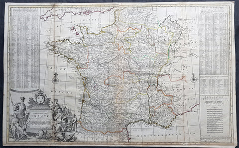
1720 Herman Moll Large Antique Pre Revolutionary Map of France in Provinces
- Title : A New and Exact Map of France Divided into all its Provinces...by H Moll Geographer
- Size: 39 1/2in x 25in (1.00m x 630mm)
- Condition: (A) Very Good Condition
- Date : 1720
- Ref #: 43196
Description:
This very large beautifully hand coloured original copper-plate engraved antique map of France by Herman Moll was published in 1720 in the atlas The World Described, or a New and Correct Sett of Maps by John Bowles, Thomas Bowles, Philip Overton & John King of London.
In the 18th century many large-scale maps were published by the likes of John Senex and Herman Moll, this trend continued until the end of private mapping in the early 19th century when it was replaced by Ordnance Survey maps.
General Definitions:
Paper thickness and quality: - Heavy and stable
Paper color : - off white
Age of map color: - Original
Colors used: - Yellow, green, blue, pink
General color appearance: - Authentic
Paper size: - 39 1/2in x 25in (1.00m x 630mm)
Plate size: - 39 1/2in x 25in (1.00m x 630mm)
Margins: - Min 1/2in (12mm)
Imperfections:
Margins: - Age toning, bottom margin extended from plate-mark
Plate area: - Light age toning along folds
Verso: - Re-enforced along folds
Background:
The Carolingian dynasty ruled France until 987, when Hugh Capet, Duke of France and Count of Paris, was crowned King of the Franks. His descendants—the Capetians, the House of Valois, and the House of Bourbon—progressively unified the country through wars and dynastic inheritance into the Kingdom of France, which was fully declared in 1190 by Philip II Augustus. The French nobility played a prominent role in most Crusades in order to restore Christian access to the Holy Land. French knights made up the bulk of the steady flow of reinforcements throughout the two-hundred-year span of the Crusades, in such a fashion that the Arabs uniformly referred to the crusaders as Franj caring little whether they really came from France. The French Crusaders also imported the French language into the Levant, making French the base of the lingua franca (litt. Frankish language) of the Crusader states. French knights also made up the majority in both the Hospital and the Temple orders. The latter, in particular, held numerous properties throughout France and by the 13th century were the principal bankers for the French crown, until Philip IV annihilated the order in 1307. The Albigensian Crusade was launched in 1209 to eliminate the heretical Cathars in the southwestern area of modern-day France. In the end, the Cathars were exterminated and the autonomous County of Toulouse was annexed into the crown lands of France. Later kings expanded their domain to cover over half of modern continental France, including most of the north, centre and west of France. Meanwhile, the royal authority became more and more assertive, centred on a hierarchically conceived society distinguishing nobility, clergy, and commoners.
From the 11th century, the House of Plantagenet, the rulers of the County of Anjou, succeeded in establishing its dominion over the surrounding provinces of Maine and Touraine, then progressively built an empire that spanned from England to the Pyrenees and covering half of modern France. Tensions between the kingdom of France and the Plantagenet empire would last a hundred years, until Philip Augustus of France conquered between 1202 and 1214 most of the continental possessions of the empire, leaving England and Aquitaine to the Plantagenets. Following the Battle of Bouvines, the Angevin court retreated to England, but persistent Capetian–Plantagenet rivalry would paved the way for another conflict.
Charles IV the Fair died without an heir in 1328. Under the rules of the Salic law the crown of France could not pass to a woman nor could the line of kingship pass through the female line. Accordingly, the crown passed to Philip of Valois, a cousin of Charles, rather than through the female line to Charles nephew, Edward of Plantagenet, who would soon become Edward III of England. During the reign of Philip of Valois, the French monarchy reached the height of its medieval power. Philips seat on the throne was contested by Edward III of England and in 1337, on the eve of the first wave of the Black Death, England and France went to war in what would become known as the Hundred Years War. The exact boundaries changed greatly with time, but French landholdings of the English Kings remained extensive for decades. With charismatic leaders, such as Joan of Arc and La Hire, strong French counterattacks won back English continental territories. Like the rest of Europe, France was struck by the Black Death; half of the 17 million population of France died.
The French Renaissance saw a spectacular cultural development and the first standardisation of the French language, which would become the official language of France and the language of Europes aristocracy. It also saw a long set of wars, known as the Italian Wars, between France and the House of Habsburg. French explorers, such as Jacques Cartier or Samuel de Champlain, claimed lands in the Americas for France, paving the way for the expansion of the First French colonial empire. The rise of Protestantism in Europe led France to a civil war known as the French Wars of Religion, where, in the most notorious incident, thousands of Huguenots were murdered in the St. Bartholomews Day massacre of 1572. The Wars of Religion were ended by Henry IVs Edict of Nantes, which granted some freedom of religion to the Huguenots. Spanish troops, the terror of Western Europe, assisted the Catholic side during the Wars of Religion in 1589–1594, and invaded northern France in 1597; after some skirmishing in the 1620s and 1630s, Spain and France returned to all-out war between 1635 and 1659. The war cost France 300,000 casualties.
Under Louis XIII, the energetic Cardinal Richelieu promoted the centralisation of the state and reinforced the royal power by disarming domestic power holders in the 1620s. He systematically destroyed castles of defiant lords and denounced the use of private violence (dueling, carrying weapons, and maintaining private army). By the end of 1620s, Richelieu established the royal monopoly of force as the doctrine. During Louis XIVs minority and the regency of Queen Anne and Cardinal Mazarin, a period of trouble known as the Fronde occurred in France. This rebellion was driven by the great feudal lords and sovereign courts as a reaction to the rise of royal absolute power in France.
The monarchy reached its peak during the 17th century and the reign of Louis XIV. By turning powerful feudal lords into courtiers at the Palace of Versailles, Louis XIVs personal power became unchallenged. Remembered for his numerous wars, he made France the leading European power. France became the most populous country in Europe and had tremendous influence over European politics, economy, and culture. French became the most-used language in diplomacy, science, literature and international affairs, and remained so until the 20th century. France obtained many overseas possessions in the Americas, Africa and Asia. Louis XIV also revoked the Edict of Nantes, forcing thousands of Huguenots into exile.
Under Louis XV, Louis XIVs great-grandson, France lost New France and most of its Indian possessions after its defeat in the Seven Years War (1756–63). Its European territory kept growing, however, with notable acquisitions such as Lorraine (1766) and Corsica (1770). An unpopular king, Louis XVs weak rule, his ill-advised financial, political and military decisions – as well as the debauchery of his court– discredited the monarchy, which arguably paved the way for the French Revolution 15 years after his death.
Louis XVI, Louis XVs grandson, actively supported the Americans, who were seeking their independence from Great Britain (realised in the Treaty of Paris (1783)). The financial crisis aggravated by Frances involvement in the American Revolutionary War was one of many contributing factors to the French Revolution. Much of the Enlightenment occurred in French intellectual circles, and major scientific breakthroughs and inventions, such as the discovery of oxygen (1778) and the first hot air balloon carrying passengers (1783), were achieved by French scientists. French explorers, such as Bougainville and Lapérouse, took part in the voyages of scientific exploration through maritime expeditions around the globe. The Enlightenment philosophy, in which reason is advocated as the primary source for legitimacy and authority, undermined the power of and support for the monarchy and helped pave the way for the French Revolution.
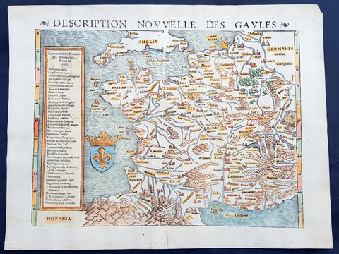
1545 Sebastian Munster Antique Map of France
- Title : Description Novvelle Des Gaules
- Ref #: 50676
- Size: 16in x 12 1/2in (405mm x 320mm)
- Date : 1545
- Condition: (A+) Fine Condition
Description:
This fine beautifully hand coloured original antique map of modern contemporary France in the mid 16th century was published by Sebastian Munster in the 1545 edition of Ptolemy's Geographia, with 54 maps based on text by the Greek Mathematician Claude Ptolemy.
Munster's Geographia (first published in 1540) and his later Cosmographia were cartographic landmarks. The Geographia included not only Ptolemaic maps, but also a number of landmark modern maps, including the first separate maps of the 4 continents, the first map of England and the earliest obtainable map of Scandinavia. TheCosmographia (first published in 1544) was the earliest German description of the world and a major work in the revival of geographic thought in 16th-century Europe. Altogether, about 40 editions of the Cosmographia appeared between 1544 and 1628.
Munster dominated cartographic publication during the mid-16th Century and is generally regarded as one of the important map makers of the 16th Century.
Geographia: contained a total of 54 woodcut maps, first published in 1540 and re-issued until 1552. Munsters "contemporary" maps were a result of data sent to him by German and European scholars of description of the villages, towns trades etc in their regions. The response was so great that over a 12 year period Munster was able to compile the first of many up-to-date, if not accurate, maps in both his two major publications, Geographia and Cosmographia. The result was one of the first comprehensive cartographical publications of regions of Europe and other parts of the world. Also as was the case with many cartographical publications of the time ancient maps interpreted from the text of the scholar Ptolemy were included along side the "modern" ones.
Claude Ptolemy: a Greek mathematician, astronomer and geographer, living in Alexandria, assembled and codified his predecessors' cartographic theories including those of Strabo & Marinus of Tyre (c. AD 120) to whom he was especially indebted. In about AD 150 he published his Geographia, a work in 8 volumes, supposedly illustrated with a world map, 26 regional maps and a profusion of smaller maps. Although the text of the Geographia survived, no maps older than about the twelfth century have come down to us and, in consequence, we have no means of knowing whether the 'Ptolemy' maps on which we set so much store were, in fact, drawn by him or were the interpretations of later map makers using his text as a basis.
In Europe the initial awakening of interest in geography arose from the revival of knowledge of Ptolemy's Geographia soon after the year 1400. Greek manuscript copies made in the twelfth to fourteenth centuries were brought by scholars to Italy from Constantinople and were subsequently translated into Latin and widely studied. This work coincided with, and was much influenced by, the development of printing techniques, particularly, of course, by the invention of movable-type printing by Gutenberg about 1450, which made possible for the first time the production of printed books in quantity. Apart from this factor, other more far-reaching influences were compelling the peoples of Western Europe to look beyond the horizon they had known for so many centuries. With the conquest of Constantinople in 1453 the Turks effectively closed Europe's trade routes to the East and shut off access to traditional sources of luxuries and precious metals from Asia and, above all, denied the supply of the spices which had become so important in the lives of ordinary people. Other factors often based on long-believed myths and legends added to the urge to break out into the unknown world.
The interpretation of Ptolemy's text began mainly with the Italians Angelus, Beroaldus & Vadius in 1477 and was re-interpreted and re-issued by many over the next century by the likes Waldseemuller 1513, Gastaldi 1548, Mercator 1578 & Magini 1596.
Sebastian Münster (1488-1552) was a German cartographer, cosmographer, and Hebrew scholar whose work Cosmographia (1544; "Cosmography") was the earliest German description of the world and a major work in the revival of geographic thought in 16th-century Europe. It had numerous editions in different languages including Latin, French, Italian, English, and even Czech. Altogether, about 40 editions of the Cosmographia appeared between 1544 and 1628 and was one of the most successful and popular books of the 16th century.Münster was a major influence in popular thinking in Europe for the next 200 years.
This success was due not only to the level of descriptive detail but also to the fascinating full page maps & views as well as smaller woodcuts that were included in the text. Many of the woodcuts were executed by famous engravers of the time including Hans Holbein the Younger, Urs Graf, Hans Rudolph Manuel Deutsch, and David Kandel.
Aside from the well-known maps present in the Cosmographia, the text is thickly sprinkled with vigorous views: portraits of kings and princes, costumes and occupations, habits and customs, flora and fauna, monsters, wonders, and horrors about the known -- and unknown -- world, and was undoubtedly one of the most widely read books of its time.
Münster acquired the material for his book in three ways. Firstly he researched all available literary sources across Germany, Switzerland and other parts of Europe. Secondly he obtained original manuscript material from locals all over Europe for description of the countryside, cities, villages, towns, rivers and local history. Finally, he obtained further material first hand on his travels (primarily in south-west Germany, Switzerland, and Alsace).
In 1588 Sebastian Petri re-released Cosomgraphia and re-issued many of Munsters maps and views in the "copperplate style". The maps in this release were more sophisticated than with earlier publications of Cosomgraphia and were based on the 1570 release of Abraham Ortelius monumental workTheatrum Orbis Terrarum. (Ref: Shirley; Tooley; M&B)
General Description:
Paper thickness and quality: - Heavy and stable
Paper color: - White
Age of map color: - Early
Colors used: - Brown, yellow, orange, blue
General color appearance: - Authentic
Paper size: - 16in x 12 1/2in (405mm x 320mm)
Plate size: - 16in x 12 1/2in (405mm x 320mm)
Margins: - Min 1in (25mm)
Imperfections:
Margins: - None
Plate area: - None
Verso: - Verso backed in transparent archival Japanese tissue
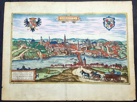
1574 Braun & Hogenberg Antique Map View of Gorlitz-Zgorzelec, Germany & Poland
- Title : Gorlitz
- Ref #: 93431
- Size: 22in x 16 1/2in (560mm x 420mm)
- Date : 1574
- Condition: (A+) Fine Condition
Description:
This original beautifully hand coloured copper plate engraved antique map a birds eye view of the Gorlitz, in the state of Saxony, in the region of Lusatia, in far eastern Germany, on the border with Poland, was published in the 1574 edition of Braun & Hogenbergs atlas Civitates Orbis Terrarum
General Definitions:
Paper thickness and quality: - Heavy and stable
Paper color : - off white
Age of map color: - Original
Colors used: - Yellow, green, blue, pink
General color appearance: - Authentic
Paper size: - 22in x 16 1/2in (560mm x 420mm)
Plate size: - 20in x 12 1/2in (510mm x 320mm)
Margins: - Min 1in (25mm)
Imperfections:
Margins: - Light soiling
Plate area: - None
Verso: - Light soiling
Background:
As a small Sorbian village named Gorelic in the Margraviate of Meissen, a frontier march of the Holy Roman Empire, Gorlitz was temporarily conquered and held by the Kingdom of Poland during Bolesław I Chrobrys invasion of Lusatia between 1002 and 1031, after which the region fell back to the Margraviate of Meissen. In 1075, the village was assigned to the Duchy of Bohemia. The date of the towns foundation is unknown. However, Goreliz was first mentioned in a document from the King of Germany, and later Holy Roman Emperor, Henry IV in 1071. This document granted Gorlitz to the Diocese of Meissen, then under Bishop Benno of Meissen. Currently, this document can be found in the Saxony State Archives in Dresden.[3] The origin of the name Gorlitz is derived from the Slavic word for burned land,[4] referring to the technique used to clear land for settlement. Zgorzelec and Czech Zhořelec have the same derivation. In the 13th century the village gradually became a town. Due to its location on the Via Regia, an ancient and medieval trade route, the settlement prospered.
In the following centuries Gorlitz was a wealthy member of the Lusatian League, which consisted of Bautzen, Gorlitz, Kamenz, Lauban, Löbau and Zittau. In 1352 during the reign of Casimir the Great, Lusatian German colonists from Gorlitz founded the town of Gorlice in southern Poland near Kraków.
The Protestant Reformation came to Gorlitz in the early 1520s and by the last half of the 16th century, it and the surrounding vicinity, became almost completely Lutheran.
After suffering for years in the Thirty Years War, the region of Upper Lusatia (including Gorlitz) was ceded to the Electorate of Saxony in 1635. After the Napoleonic Wars, the 1815 Congress of Vienna transferred the town from the Kingdom of Saxony to the Kingdom of Prussia. Gorlitz was subsequently administered within the Province of Silesia, and, after World War I, the Province of Lower Silesia, until 1945.
From 1815 until 1918, Gorlitz belonged to the Province of Silesia in the Kingdom of Prussia, and later to the Province of Lower Silesia in the Free State of Prussia. It is the largest town of the former Province of Lower Silesia that lies west of the Oder-Neisse line and hence remained in Germany after World War II. Today, Gorlitz lies opposite the Polish town of Zgorzelec, which was part of Gorlitz until 1945. Together they form the German-Polish Euro City of Gorlitz-Zgorzelec.
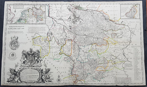
1720 Moll Large Antique Map Brunswick Luneburg, NW Germany - Dedicated to George I
- Title : A New & Exact Map of the Electorate of Brunswick-Lunenburg and ye rest of ye Kings Dominions in Germany, very much Improved by ye kind Assistance of severall Curious Gentlemen . . . To His Most Sacred Majesty George King of Great Britain, France and Ireland, Elector of Brunswick-Lunenburg &c
- Size: 41in x 24 1/2in (1.015m x 620mm)
- Condition: (A+) Fine Condition
- Date : 1720
- Ref #: 93043
Description:
This very large beautifully hand coloured original superbly executed copper-plate engraved antique map of the Electorate of Brunswick Luneburg in NW Germany, by Herman Moll, was published in 1720 in the atlas The World Described, or a New and Correct Sett of Maps by John Bowles, Thomas Bowles, Philip Overton & John King of London.
In the 18th century many large-scale maps were published by the likes of John Senex and Herman Moll, this trend continued until the end of private mapping in the early 19th century when it was replaced by Ordnance Survey maps.
General Definitions:
Paper thickness and quality: - Heavy and stable
Paper color : - off white
Age of map color: - Original
Colors used: - Yellow, green, blue, pink
General color appearance: - Authentic
Paper size: - 41in x 24 1/2in (1.015m x 620mm)
Plate size: - 41in x 24 1/2in (1.015m x 620mm)
Margins: - Min 1/2in (12mm)
Imperfections:
Margins: - Age toning along top margin
Plate area: - Folds as issued
Verso: - Backed onto original haevy paper
Background:
Fine decorative map of Brunswick-Lunenburg and environs, dedicated to King George I, of Great Britain, who was also an Elector of the Holy Roman Empire, and Ruler of the Duchy and Electorate of Brunswick-Luneburg.
At top center is the estuarial northern part of the Elbe River facing Hamburg, while Hanover appears near the center of the map.
Molls depiction of the royal arms and other embellishments surrounding the cartouche display his considerable engraving talents.
Published shortly after King George I ascendancy to the throne as King of England, in 1714, the map marks one of the more fascinating chapters in British History and a turning point in the history and power structure of the British Monarchy.
The Inset maps show:
1. Part of England
2. Netherlands
3. Part of Germany (showing route of the King from Hannover to Greenwich)
4. Duchy of Saxon Lauwenburg
King George I
George I (1660 - 1727), was King of Great Britain and Ireland from August 1, 1714, until his death, and ruler of the Duchy and Electorate of Brunswick-Lüneburg (Hanover) in the Holy Roman Empire, from 1698.
George was born in Hanover and inherited the titles and lands of the Duchy of Brunswick-Lüneburg from his father and uncles. A succession of European wars expanded his German domains during his lifetime and in 1708 he was ratified as prince-elector of Hanover.
At the age of 54, after the death of Queen Anne of Great Britain, George ascended the British throne as the first monarch of the House of Hanover. Although over fifty Roman Catholics bore closer blood relationships to Anne, the Act of Settlement 1701 prohibited Catholics from inheriting the British throne.
George was Anne\'s closest living Protestant relative. In reaction, Jacobites attempted to depose George and replace him with Anne\'s Catholic half-brother, James Francis Edward Stuart, but their attempts failed.
During George\'s reign, the powers of the monarchy diminished and Britain began a transition to the modern system of cabinet government, led by a prime minister. Towards the end of his reign, actual power was held by Sir Robert Walpole, now recognized as Britain\'s first de facto prime minister.
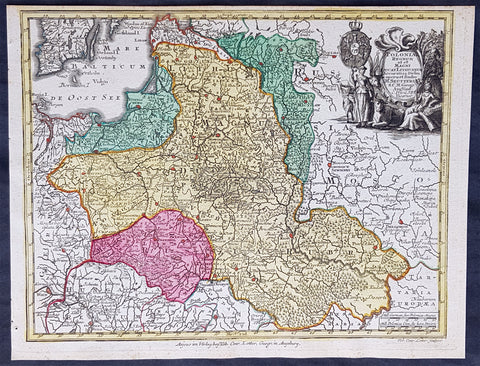
1744 Georg Mattaus Seutter Antique Map of Poland, Lithuania & Baltic Countries
- Title : Polonia Regnum ul et Magni Ducat Lithuania........a Matth. Seutteri...T C Lotter, Geogr.
- Ref #: 93400
- Size: 11in x 8 1/2in (280mm x 215mm)
- Date : 1744
- Condition: (A+) Fine Condition
Description:
This beautifully hand coloured original copper-plate engraved antique map of Poland, Lithuania & the Baltic Countries was engraved by Tobias Lotter and was published in the 1744 edition of GM Seutters Atlas Minor Prae cipua Orbis Terrarum Imperia Regna et Provincias...., Augsburg, Germany.
General Definitions:
Paper thickness and quality: - Heavy and stable
Paper color : - off white
Age of map color: - Original
Colors used: - Yellow, green, blue, pink
General color appearance: - Authentic
Paper size: - 11in x 8 1/2in (280mm x 215mm)
Plate size: - 10 1/2in x 8in (265mm x 205mm)
Margins: - Min 1/4in (5mm)
Imperfections:
Margins: - None
Plate area: - None
Verso: - None
Background:
Atlas Minor was a series of beautiful maps of all parts of the world. Georg Matthäus Seutter was one of the most and important of the German cartographers of the 18th century, being appointed as the Geographer to the Imperial Court. His son, Albrecht Carl, joined Matthäus and eventually inherited the business. The maps from Atlas Minor were drawn by the two Seutters and engraved by Tobias Conrad Lotte. These maps are highly detailed and engraved with a bold hand with equally strong original hand color in the body of the map as was the 18th century German style. The cartouches were left uncolored in order to emphasize the elaborately detailed illustrations for which German maps are especially prized. These are some of the most decorative and interesting maps of the eighteenth century.
1788 Vicente Tofino Large Antique Map of San Sebastian & La Concha, Basque Spain
- Title : Plano de la plaza y puerto de San Sebastian Capital de la Provincia de Guipuzcoa, situado el castillo de la Mota en... Ano 1788
- Size: 23 1/2in x 17in (595mm x 435mm)
- Condition: (B) Good Condition
- Date : 1788
- Ref #: 80774
Description:
This large original copper plate engraved scarce antique map of the city of San Sebastian and the Bay of La Concha on the northern Basque coast of Spain by the Spanish navigator and cosmographer Vincente Tofiño de San Miguel was engraved in 1788 - dated - and was published in Tofinos 1789 edition of Derrotero de las costas de España en el Océano Atlántico y de las islas Azores o Terceras, para inteligencia y uso de las cartas esféricas (Pilots Log-book of the Coasts of Spain in the Atlantic Ocean and of the Azores, for the use of naval intelligence and nautical charts).
General Definitions:
Paper thickness and quality: - Heavy and stable
Paper color : - off white
Age of map color: -
Colors used: -
General color appearance: -
Paper size: - 23 1/2in x 17in (595mm x 435mm)
Plate size: - 23 1/2in x 17in (595mm x 435mm)
Margins: - Min 1/4in (5mm)
Imperfections:
Margins: - 5 small repairs to margins going into image
Plate area: - Soiling, small separation of bottom centerfold
Verso: - Soiling
Background:
San Sebastián is a coastal city and municipality located in the Basque Autonomous Community, Spain
After a long period of silence in evidence, in 1014 the monastery of St. Sebastián with its apple orchards (for cider), located in the term of Hernani, is donated to the Abbey of Leire by Sancho III of Pamplona. By 1181, the city is chartered (given fuero) by king Sancho VI of Pamplona on the site of Izurum, having jurisdiction over all the territory between the rivers Oria and Bidasoa.
In 1200, the city was conquered by Castile, whose king Alfonso VIII, confirmed its charter (fuero), but the Kingdom of Navarre was deprived of its main direct access out to the sea. Perhaps as soon as 1204 (or earlier), the city nucleus at the foot of Urgull started to be populated with Gascon-speaking colonizers from Bayonne and beyond, who left an important imprint in the citys identity in the centuries to come.
In 1265, the use of the city as a seaport is granted to Navarre as part of a wedding pact. The large quantity of Gascons inhabiting the town favoured the development of trade with other European ports and Gascony. The city steered clear of the destructive War of the Bands in Gipuzkoa, the only town in doing so in that territory. In fact, the town only joined Gipuzkoa in 1459 after the war came to an end. Up to the 16th century, Donostia remained mostly out of wars, but by the beginning of the 15th century, a line of walls of simple construction is attested encircling the town. The last chapter of the town in the Middle Ages was brought about by a fire that devastated Donostia in 1489. After burning to the ground, the town began a new renaissance by building up mainly with stone instead of bare timber.
The advent of the Modern Age brought a period of instability and war for the city. New state boundaries were drawn that left Donostia located close to Spains border with France; thicker and more sophisticated walls were erected, with the town becoming involved in the 1521-1524 military campaigns that formed part of the Spanish conquest of Navarre. The town provided critical naval help to Emperor Charles V during the siege of Hondarribia, which earned the town the titles Muy Noble y Muy Leal, recorded on its coat of arms. The town also aided the monarch by sending a party to the Battle of Noain and providing help to quash the Revolt of the Comuneros in 1521.
After these events, Gascons, who had played a leading role in the political and economic life of the town since its foundation, began to be excluded from influential public positions by means of a string of regional sentences upheld by royal decision (regional diets of Zestoa 1527, Hondarribia 1557, Bergara 1558, Tolosa 1604 and Deba 1662). Meanwhile, the climate of war and disease left the town in a poor condition that drove many fishermen and traders to take to the sea as corsairs as a way of getting a living, most of the times under the auspices of the king Philip II of Spain, who benefited from the disruption caused to and wealth obtained from the French and Dutch trade ships.
In 1656, the city was used as the royal headquarters during the marriage of the Infanta to Louis XIV at Saint-Jean-de-Luz nearby. After a relatively peaceful 17th century, the town was besieged and taken over by the troops of the French Duke of Berwick up to 1721. However, San Sebastián was not spared by shelling in the French assault and many urban structures were reconstructed, e.g. a new opening in the middle of the town, the Plaza Berria (that was to become the current Konstituzio Plaza).
In 1728, the Compañía Guipuzcoana de Caracas was founded and boosted commerce with the Americas. Thanks to the profit the company generated, the town underwent some urban reforms and improvements and the new Santa Maria Church was erected by subscription. This period of wealth and development was to last up to the end of 18th century.
In 1808, Napoleonic forces captured San Sebastián in the Peninsular War. In 1813, after a siege of various weeks, on 28 August, during the night, a landing party from a British Royal Navy squadron captured Santa Clara Island, in the bay. Situated on a narrow promontory that jutted out into the sea between the waters of the Bay of Biscay and the broad estuary of the Urumea River, the town was hard to get at and well fortified – it was the strongest fortification I ever saw, Gibraltar excepted, wrote William Dent. Three days later, on 31 August, British and Portuguese troops besieging San Sebastián assaulted the town. The relieving troops ransacked and burnt the city to the ground. Only the street at the foot of the hill (now called 31 August Street) remained.
Vicente Tofino de San Miguel y Wanderiales 1732 - 1795
Vicente Tofino de San Miguel y Wanderiales (or Vanderiales) was a Spanish navigator and cosmographer.
He studied experimental physics and then joined the army, which he subsequently left. In 1755 Jorge Juan asked Tofiño to join the faculty of the Academy of Marines at Cádiz (Academia de Guardia Marinas de Cádiz) as a mathematics instructor, while also allowing Tofiño to join the Armada as a second lieutenant (alférez de navío). In 1768 Tofiño was named Director of the Academy and in 1773, was named Director of the Academies of Ferrol and Cartagena as well. He participated in the expeditions against Algiers (1773) and the Great Siege of Gibraltar (1782). He acquired the rank of Brigadier of the Armada in 1784, and in 1789 the rank of Rear Admiral.
He planned the initial construction, and worked at, the Royal Institute and Observatory of the Armada (Real Instituto y Observatorio de la Armada) of the Company of Marines, publishing observations with great scientific skill, like the transit of Venus by the Sun, taking advantage of an eclipse on 3 June 1796.
Tofiño went to sea and the result of this was several works, including Derrotero de las costas de España en el mar Mediterráneo y África (1787) (Pilots Log-book of the Coasts of Spain in the Mediterranean Sea and Africa); his colección de cartas esféricas de las costas de España y África... (1788) (Collection of Nautical Charts of the Coasts of Spain and Africa) and the Derrotero de las costas de España en el Océano Atlántico y de las islas Azores o Terceras, para inteligencia y uso de las cartas esféricas (1789) (Pilots Log-book of the Coasts of Spain in the Atlantic Ocean and of the Azores, for the use of naval intelligence and nautical charts).
Due to an error in transcription on one of Tofiños maps, the island of Mogro (Santander) came to be called Mouro Island. Tofino Inlet, from which the town of Tofino got its name, was named in 1792 by the Spanish explorers Galiano and Valdés, in honor of Admiral Tofiño, under whom Galiano had learned cartography.