British Isles (10)

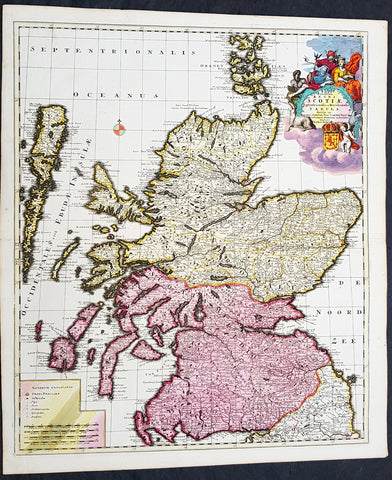
1646 Joan Blaeu Large Antique Map of Scotland - Scotia Regnum
- Title : Scotia Regnum
- Ref #: 61001
- Size: 22 3/4in x 19 3/4in (580mm x 500mm)
- Date : 1646
- Condition: (A+) Fine Condition
Description:
This large beautifully hand coloured original antique map of Scotland was published in the 1646 Dutch edition of Joan Blaeu's Atlas Novus.
General Description:
Paper thickness and quality: - Heavy
Paper color: - White
Age of map color: - Original
Colors used: - Yellow, pink, red, blue, green
General color appearance: - Authentic
Paper size: - 22 3/4in x 19 3/4in (580mm x 500mm)
Plate size: - 20in x 15 1/4in (510mm x 385mm)
Margins: - Min 1in (25mm)
Imperfections:
Margins: - None
Plate area: - None
Verso: - None
Background: When the Blaeu's published Volume V - GB & Ireland - of Atlas Novus, Scotland became one of the best-mapped countries in the world. Volume V contained forty-eight plates showing forty-nine separate maps of Scotland (plus a map of Ptolemy British Isles and six maps of Ireland). The first two plates from the atlas show the entire country ancient and modern, whilst the remaining forty-six plates cover most Scotland in forty-seven regional maps. In total the regional maps locate some 20,000 different place names. A clue as to the reason for this extraordinary explosion of geographical information is to be found on thirty-six of the regional maps, which all carry engraved credits to Timothy Pont (1524-1606)
Pont was responsible for surveying the greater part of Scotland between 1583-1600, the resulting Pont Manuscript maps were never published but were put to good use some fifty to seventy years later by Robert Gordon and Joan Blaeu. (Ref: Koeman; Tooley; M&B)
1708 Pieter Schenk Large Antique Map of Scotland - Beautiful Hand Colouring
- Title : Novissima Regni Scotia Septrionalis et Merdionalis Tabula
- Date : 1708
- Condition: (A+) Fine Condition
- Ref: 93524
- Size: 24 1/2in x 21in (620mm x 535mm)
Description:
This large original copper plate engraved beautifully hand coloured antique map of Scotland was engraved and published by Pieter Schenk in 1708 - dated in cartouche.
This is one of the finest and beautifully hand colored map of Scotland I have seen for sometime
General Definitions:
Paper thickness and quality: - Heavy and stable
Paper color : - off white
Age of map color: - Original
Colors used: - Yellow, green, blue, pink
General color appearance: - Authentic
Paper size: - 24 1/2in x 21in (620mm x 535mm)
Plate size: - 23 1/2in x 19 1/2in (595mm x 495mm)
Margins: - Min 1/2in (12mm)
Imperfections:
Margins: - None
Plate area: - None
Verso: - None
Background:
The Treaty of Perpetual Peace was signed in 1502 by James IV of Scotland and Henry VII of England. James married Henrys daughter, Margaret Tudor. James invaded England in support of France under the terms of the Auld Alliance and became the last British monarch to die in battle, at Flodden in 1513. In 1560, the Treaty of Edinburgh brought an end to the Anglo-French conflict and recognized the Protestant Elizabeth I as Queen of England. The Parliament of Scotland met and immediately adopted the Scots Confession, which signaled the Scottish Reformations sharp break from papal authority and Catholic teaching. The Catholic Mary, Queen of Scots was forced to abdicate in 1567.
In 1603, James VI, King of Scots inherited the thrones of the Kingdom of England and the Kingdom of Ireland in the Union of the Crowns, and moved to London. The military was strengthened, allowing the imposition of royal authority on the western Highland clans. The 1609 Statutes of Iona compelled the cultural integration of Hebridean clan leaders. With the exception of a short period under the Protectorate, Scotland remained a separate state, but there was considerable conflict between the crown and the Covenanters over the form of church government. The Glorious Revolution of 1688–89 saw the overthrow of King James VII of Scotland and II of England by the English Parliament in favour of William III and Mary II In common with countries such as France, Norway, Sweden and Finland, Scotland experienced famines during the 1690s. Mortality, reduced childbirths and increased emigration reduced the population of parts of the country about 10-15%.
In 1698, the Company of Scotland attempted a project to secure a trading colony on the Isthmus of Panama. Although it received a huge investment, the Darien scheme failed, partially due to English hostility. Along with the threat of an English invasion, the resulting bankruptcies played a leading role in convincing the Scots elite to back a union with England. On 22 July 1706, the Treaty of Union was agreed between representatives of the Scots Parliament and the Parliament of England. The following year twin Acts of Union were passed by both parliaments to create the united Kingdom of Great Britain with effect from 1 May 1707 with popular opposition and anti-union riots in Edinburgh, Glasgow, and elsewhere.
With trade tariffs with England now abolished, trade blossomed, especially with Colonial America. The clippers belonging to the Glasgow Tobacco Lords were the fastest ships on the route to Virginia. Until the American War of Independence in 1776, Glasgow was the worlds premier tobacco port, dominating world trade. The deposed Jacobite Stuart claimants had remained popular in the Highlands and north-east, particularly amongst non-Presbyterians, including Roman Catholics and Episcopalian Protestants. However, two major Jacobite risings launched in 1715 and 1745 failed to remove the House of Hanover from the British throne. The threat of the Jacobite movement to the United Kingdom and its monarchs effectively ended at the Battle of Culloden, Great Britains last pitched battle.
The Scottish Enlightenment and the Industrial Revolution turned Scotland into an intellectual, commercial and industrial powerhouse so much so Voltaire said We look to Scotland for all our ideas of civilisation. With the demise of Jacobitism and the advent of the Union, thousands of Scots, mainly Lowlanders, took up numerous positions of power in politics, civil service, the army and navy, trade, economics, colonial enterprises and other areas across the nascent British Empire. Historian Neil Davidson notes after 1746 there was an entirely new level of participation by Scots in political life, particularly outside Scotland. Davidson also states far from being peripheral to the British economy, Scotland – or more precisely, the Lowlands – lay at its core. In the Highlands, clan chiefs gradually started to think of themselves more as commercial landlords than leaders of their people. These social and economic changes included the first phase of the Highland Clearances and, ultimately, the demise of the clan system. In the last third of the 18th century, Highlanders began to migrate seasonally to Lowland cities for work, and emigration to the New World from both the Highlands and Lowlands became commonplace, even as the population increased
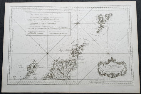
1757 Bellin Large Antique Map of Scotland, Orkneys, Shetlands, Lewis & Harris
- Title : Carte Reduite des Isles Britanniques Quatrieme Feuille Partie Septentrionale de l Ecosse. 1757
- Size: 37 1/2in x 25 1/2in (950mm x 650mm)
- Condition: (A+) Fine Condition
- Date : 1757
- Ref #: 35501
Description:
This very large finely engraved original copper-plate engraved antique map, Sea Chart, of northern Scotland, Orkney & Shetland Islands, Lewis & Harris - along with relief inset of Orkneys - by Jacques Nicolas Bellin in 1757 - dated in the title cartouche.
General Definitions:
Paper thickness and quality: - Heavy and stable
Paper color : - off white
Age of map color: -
Colors used: -
General color appearance: -
Paper size: - 37 1/2in x 25 1/2in (950mm x 650mm)
Plate size: - 35 1/2in x 24in (900mm x 580mm)
Margins: - Min 1in (25mm)
Imperfections:
Margins: - None
Plate area: - None
Verso: - None
Background:
In the 14th century, Orkney and Shetland remained a Norwegian possession, but Scottish influence was growing. Jon Haraldsson, who was murdered in Thurso in 1231, was the last of an unbroken line of Norse jarls, and thereafter the earls were Scots noblemen of the houses of Angus and St Clair. On the death of Haakon VI in 1380, Norway formed a political union with Denmark, after which the interest of the royal house in the islands declined. In 1469, Shetland was pledged by Christian I, in his capacity as King of Norway, as security against the payment of the dowry of his daughter Margaret, betrothed to James III of Scotland. As the money was never paid, the connection with the Crown of Scotland became permanent. In 1470, William Sinclair, 1st Earl of Caithness ceded his title to James III, and the following year the Northern Isles were directly annexed to the Crown of Scotland, an action confirmed by the Parliament of Scotland in 1472. Nonetheless, Shetlands connection with Norway has proved to be enduring.
From the early 15th century on the Shetlanders sold their goods through the Hanseatic League of German merchantmen. The Hansa would buy shiploads of salted fish, wool and butter, and import salt, cloth, beer and other goods. The late 16th century and early 17th century were dominated by the influence of the despotic Robert Stewart, Earl of Orkney, who was granted the islands by his half-sister Mary Queen of Scots, and his son Patrick. The latter commenced the building of Scalloway Castle, but after his imprisonment in 1609 the Crown annexed Orkney and Shetland again until 1643 when Charles I granted them to William Douglas, 7th Earl of Morton. These rights were held on and off by the Mortons until 1766, when they were sold by James Douglas, 14th Earl of Morton to Laurence Dundas.
The trade with the North German towns lasted until the 1707 Act of Union, when high salt duties prevented the German merchants from trading with Shetland. Shetland then went into an economic depression, as the local traders were not as skilled in trading salted fish. However, some local merchant-lairds took up where the German merchants had left off, and fitted out their own ships to export fish from Shetland to the Continent. For the independent farmers of Shetland this had negative consequences, as they now had to fish for these merchant-lairds.
Smallpox afflicted the islands in the 17th and 18th centuries (as it did all of Europe), but as vaccines became available after 1800, health improved. The island was very badly hit by the potato famine of 1846 and the government introduced a Relief Plan for the island under the command of Captain Robert Craigie of the Royal Navy who stayed in Lerwick to oversee the project 1847-1852. During this period Craigie also did much to improve and increase roads on the island.
Population increased to a maximum of 31,670 in 1861. However, British rule came at price for many ordinary people as well as traders. The Shetlanders nautical skills were sought by the Royal Navy. Some 3,000 served during the Napoleonic wars from 1800 to 1815 and press gangs were rife. During this period 120 men were taken from Fetlar alone, and only 20 of them returned home. By the late 19th century 90% of all Shetland was owned by just 32 people, and between 1861 and 1881 more than 8,000 Shetlanders emigrated. With the passing of the Crofters Act in 1886 the Liberal prime minister William Gladstone emancipated crofters from the rule of the landlords. The Act enabled those who had effectively been landowners serfs to become owner-occupiers of their own small farms. By this time fishermen from Holland, who had traditionally gathered each year off the coast of Shetland to fish for herring, triggered an industry in the islands that boomed from around 1880 until the 1920s when stocks of the fish began to dwindle. The production peaked in 1905 at more than a million barrels, of which 708,000 were exported
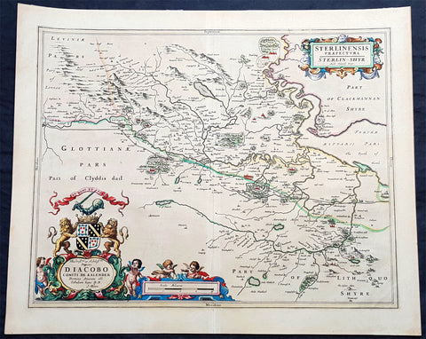
1645 Joan Blaeu Large Antique Map of The County of Stirling, Scotland, Falkirk
- Title : Sterlinensis Praefcture...Sterlin-Shyr...Auct Timoth. Pont
- Ref #: 93511
- Size: 23in x 18 1/2in (585mm x 480mm)
- Date : 1645
- Condition: (A+) Fine Condition
Description:
This large original beautifully hand coloured copper plate engraved antique map of the Scottish County of Stirling, on the river Forth just north of Edinburgh, was published in the 1645 Latin edition of Joan Blaeus Atlas Novus..
This is a beautiful map with magnificent original hand colouring, on clean paper with a heavy impression.
When Blaeu published his volume of Great Britain & Ireland, Atlas Novus, Scotland became one of the best-mapped countries in the world. The atlas contained maps of forty-nine separate maps of Scotland (plus a map of Ptolemy GB and six maps of Ireland). The first two plates from the atlas show the entire country ancient and modern, whilst the remaining forty-six plates cover most Scotland in forty-seven regional maps. In total the regional maps locate some 20,000 different place names. A clue as to the reason for this extraordinary explosion of geographical information is to be found on thirty-six of the regional maps, which all carry engraved credits to Timothy Pont (1524-1606)
Pont was responsible for surveying the greater part of Scotland between 1583-1600, the resulting Pont Manuscript maps were never published but were put to good use some fifty to seventy years later by Robert Gordon and Joan Blaeu. (Ref: Koeman; Tooley; M&B)
General Definitions:
Paper thickness and quality: - Heavy and stable
Paper color : - off white
Age of map color: - Original
Colors used: - Blue, pink, red, green, yellow
General color appearance: - Authentic
Paper size: - 23in x 18 1/2in (585mm x 480mm)
Plate size: - 20in x 16 1/2in (510mm x 420mm)
Margins: - Min 1in (25mm)
Imperfections:
Margins: - None
Plate area: - None
Verso: - None
Background:
Stirlingshire or the County of Stirling is an historic county and registration county of Scotland. Its county town is Stirling. It borders Perthshire to the north, Clackmannanshire and West Lothian to the east, Lanarkshire to the south, and Dunbartonshire to the south-east and south-west.
In 1130, Stirling, one of the principal royal strongholds of the Kingdom of Scotland, was created a Royal burgh by King David I. On 11 September 1297, the forces of Andrew Moray and William Wallace defeated the combined English forces of John de Warenne, 6th Earl of Surrey, and Hugh de Cressingham near Stirling, on the River Forth, at the Battle of Stirling Bridge during the First War of Scottish Independence.
On 22 July 1298 the Battle of Falkirk saw the defeat of William Wallace by King Edward I of England.
On 24 June 1314 the Battle of Bannockburn at Bannockburn, (Blàr Allt a\' Bhonnaich in Scottish Gaelic) was a significant Scottish victory in the Wars of Scottish Independence. It was one of the decisive battles of the First War of Scottish Independence.
On 11 June 1488 the Battle of Sauchieburn was fought at the side of Sauchie Burn, a stream about two miles south of Stirling, Stirlingshire, Scotland.[4] The battle was fought between the followers of King James III of Scotland and a large group of rebellious Scottish nobles including Alexander Home, 1st Lord Home, nominally led by the king\'s 15-year-old son, Prince James, Duke of Rothesay (reigned 1488–1513).
In 1645 the Covenanter army under General William Baillie formed near Banton for their engagement with the Royalist forces under the command of Montrose at the Battle of Kilsyth, Kilsyth, on 15 August 1645; a major battle of the Wars of the Three Kingdoms.
The Battle of Falkirk Muir on 17 January 1746 saw the Jacobites under Charles Edward Stuart defeat a government army commanded by Lieutenant General Henry Hawley.
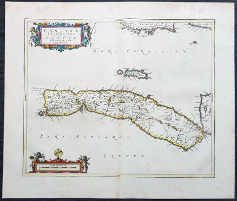
1657 Joan Blaeu Antique Map of Kintyre Peninsula Western Scotland, Argyll & Bute
- Title : Cantyra Chersonesus - Cantyr a Demie-yland..
- Ref #: 50384
- Size: 24in x 20 1/2in (610mm x 520mm)
- Date : 1657
- Condition: (A+) Fine Condition
Description:
This beautifully engraved hand coloured original antique map of the Kintyre Peninsula, located in the southwest of Argyll and Bute, Western Scotland was published in the 1657 Spanish edition of Joan Blaeu\'s Atlas Novus after the the famous Scottish Cartographer Timothy Pont (1524-1606)
When Blaeu published Volume five of his 1654 Atlas Novus of Scotland, became one of the best-mapped countries in the world. The volume contained forty-eight plates showing forty-nine separate maps of Scotland (plus a map of Ptolemy British Isles and six maps of Ireland). The first two plates from the atlas show the entire country ancient and modern, whilst the remaining forty-six plates cover most of Scotland in forty-seven regional maps. In total the regional maps locate some 20,000 different place names. A clue as to the reason for this extraordinary explosion of geographical information is to be found on thirty-six of the regional maps, which all carry engraved credits to Timothy Pont (1524-1606)
Pont was responsible for surveying the greater part of Scotland between 1583-1600, the resulting Pont Manuscript maps were never published but were put to good use some fifty to seventy years later by Robert Gordon and Joan Blaeu. (Ref: Koeman; Tooley; M&B)
General Definitions:
Paper thickness and quality: - Heavy and stable
Paper color : - off white
Age of map color: - Original
Colors used: - Blue, pink, red, green, yellow
General color appearance: - Authentic
Paper size: - 24in x 20 1/2in (610mm x 520mm)
Plate size: - 20in x 16 1/2in (510mm x 420mm)
Margins: - Min 1in (25mm)
Imperfections:
Margins: - Light age toning
Plate area: - Very light soiling
Verso: - Light showthrough
Background:
Kintyre is a peninsula in western Scotland, in the southwest of Argyll and Bute. The peninsula stretches about 30 miles, from the Mull of Kintyre in the south to East Loch Tarbert in the north. The area immediately north of Kintyre is known as Knapdale.
In 1293, king John Balliol established shrieval authority by creating the post of sheriff of Kintyre. Shortly after, Robert de Bruys launched a civil war challenging John for the throne. By this point, Somerleds descendants had formed into three families - the MacRory, the MacDougalls, and the MacDonalds; the MacDougalls took John\'s side, while the MacDonalds and MacRory backed de Bruys. When de Bruys defeated John, he declared the MacDougall lands forfeit, and gave them to the MacDonalds.
The head of the MacDonald family married the heir of the MacRory family, thereby acquiring the remaining share of Somerleds realm, and transforming it into the Lordship of the Isles, which lasted for over a century. After 4 years and 3 children, however, he divorced Amy, and married Margaret, the daughter of Robert II, the Scottish king, who gave him the remaining parts of Kintyre, along with the whole of Knapdale, as a dowry.
In 1462, however, John, the then Lord of the Isles, plotted with the English king to conquer Scotland; civil war in England delayed the discovery of this for a decade. Upon the discovery, in 1475, there was a call for forfeiture, but a year John calmed the matter, by quitclaiming Ross (Easter, Wester, and Skye), Kintyre, and Knapdale, to Scotland.
At an unclear point before 1481, the sheriffdom of Kintyre became Tarbertshire, based at Tarbert at the northern edge of Kintyre; in that year, Tarbertshire was expanded to include Knapdale. However, comital authority remained absent following the quitclaim from the Lord of the Isles; following a law and order crisis in the region, king James IV of Scotland appointed Archibald Campbell, the Earl of Argyll as governor of Tarbert Castle, with implied authority over nearby castles such as Skipness.
Following the Scottish reformation, the MacDonalds (opponents) and Campbells (supporters) came into more direct dispute. In 1607, Following a series of hostile actions from the MacDonalds, King James VI ordered the lands they landlorded in Kintyre to be transferred to the Archibald Campbell, heir of the earlier Archibald. Under pressure from the Campbells, the sheriff court moved to Inveraray at the extreme northeast of Tarbertshire, near the heart of Campbell power; somewhat inevitably, in 1633 shrieval authority was annexed by the sheriff of Argyll.
Archibalds son, a dedicated supporter of the religious reformers, developed a plan to establish a large settlement, around the village of Kinlochkilkerran, at the south of Kintyre, composed of loyal Presbyterians from Lowland Scotland, in order to outnumber and undermine the local Catholic population, and reduce resistance to the states religious reforms. Under his son, Archibald, this became Campbeltown. Their actions also had the effect of diluting Gaelic culture, gradually replacing it with a lowlands one.
Comital powers were abolished by the Heritable Jurisdictions Act, leaving only the shrieval unit. In 1899, counties were formally created, on shrieval boundaries, by a Scottish Local Government Act; Kintyre therefore became part of the County of Argyll. Following late 20th century reforms, it is now within the wider region of Argyll and Bute.
Timothy Pont (c. 1565–1614) was a Scottish cartographer and topographer, the first to produce a detailed map of Scotland. Ponts maps are among the earliest surviving to show a European country in minute detail, from an actual survey.
He was the elder son of Robert Pont, a Presbyterian cleric and politician, by his first wife, Catherine, daughter of Masterton of Grange. He matriculated as student of St. Leonard\'s College, St. Andrews, in 1580, and obtained the degree of M.A. of St Andrews University in 1584. He spent the late 1580s and the 1590s travelling throughout Scotland, mapping the country. Between 1601 and 1610 he was the minister of Dunnet Parish Church in Caithness. He was continued 7 December 1610; but he resigned some time before 1614, when the name of William Smith appears as minister of the parish. On 25 July 1609 Pont was enrolled for a share of two thousand acres (8 km²) in connection with the scheme for the plantation of Ulster, the price being 400l.
Pont was an accomplished mathematician, and the first projector of a Scottish atlas. In connection with the project he made a complete survey of all the shires and islands of the kingdom, visiting remote districts, and making drawings on the spot. A contemporary described how Pont personally surveyed...and added such cursory observations on the monuments of antiquity...as were proper for the furnishing out of future descriptions. He died having almost completed his task.
The originals of his maps, which are preserved in the National Library of Scotland, Edinburgh, are characterised by neatness and accuracy. Ponts manuscript maps are key historical documents for their time, of importance in the fields of place-names, settlements, and other studies. Many of the maps have miniature drawings of major buildings (such as castles and abbeys), obviously sketched from life. Though on a small scale and not entirely accurate, these give an idea of the appearance of many buildings that have been altered or have disappeared completely.
James VI gave instructions that they should be purchased from his heirs and prepared for publication, but on account of the disorders of the time they were nearly forgotten. Sir John Scot of Scotstarvet prevailed on Robert Gordon of Straloch to undertake their revision with a view to publication. The task of revision was completed by Gordons son, James Gordon, parson of Rothiemay, and they were published in Joan Blaeus Atlas Novus, vol. v. Amsterdam, 1654 (reissued in 1662 in vol. vi). The ‘Topographical Account of the District of Cunninghame, Ayrshire, compiled about the Year 1600 by Mr. Timothy Pont,’ was published in 1850; and was reproduced under the title Cunninghame topographized, by Timothy Pont, A.M., 1604–1608; with Continuations and Illustrative Notices by the late James Dobie of Crummock, F.S.A. Scot., edited by his son, John Shedden Dobie, Glasgow, 1876. Robert Sibbald based much of his work on Ponts.
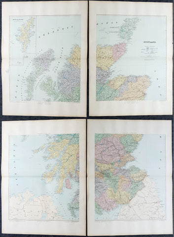
1895 Edward Stanford Very Large 4 Sheet Map of Scotland - w/ Reference Map
- Title : Scotland...London Edward Stanford 26 & 27 Cockspur St Charing Cross SW
- Ref #: 40947
- Size: 29 1/2in x 22in (750mm x 560mm) each sheet
- Date : 1895
- Condition: (A+) Fine Condition
Description:
Extremely scarce 4 sheet, very large (29 1/2in x 22in (750mm x 560mm) each sheet) lithograph map of Scotland by the famous 19th century map publisher Edward Stanford was published in 1895. (The map is not dated but we know that Stanford resided at the address noted on the map Cockspur St from 1885 to 1901). Also included is a smaller (20in x 14in 510mm x 360mm) original reference map that came with the 4 sheet publication.
This is an extremely beautiful, detailed map of Scotland.
General Definitions:
Paper thickness and quality: - Heavy and stable
Paper color : - off white
Age of map color: -
Colors used: -
General color appearance: -
Paper size: - 29 1/2in x 22in (750mm x 560mm) each sheet
Plate size: - 29 1/2in x 22in (750mm x 560mm) each sheet
Margins: - Min 2in (50mm)
Imperfections:
Margins: - None
Plate area: - None
Verso: - None
Stanford, Edward 1827-1904
Stanford was a prominent British mapmaker and publisher. A native of Holborn in the heart of London, Edward was apprenticed to a printer and stationer at the age of 14. After his first master died, he worked with several others, including Trelawny W. Saunders of Charing Cross. Saunders oversaw young Edward’s early career, ensuring that he became a Fellow of the Royal Geographical Society. Associations with the Society eventually brought Sanders much business and gave him a reputation as a publisher of explorers. As testament to this reputation, the Stanford Range in British Columbia was named for him by John Palliser.
Stanford briefly partnered with Saunders in 1852 before striking out on his own in 1853. He was an agent for the Ordnance Survey, the Admiralty, the Geological Survey, the Trigonometrical Survey of India, and the India Office. He also controlled the maps of the Society for the Diffusion of Useful Knowledge, another lucrative source of income. In 1857, Stanford founded his namesake Geographical Establishment, with Saunders and A. K. Johnston as engravers. Thereafter, Stanford was known for his library maps, particularly those of Africa and Asia.
Although he had authored many maps, the Harrow Atlas of Modern Geography and a similar volume on classical geography, Stanford is better remembered today as the leader of a successful map business. Ever in search of more inventory, he acquired the plates and stock of John Arrowsmith, heir of the Arrowmsith family firm, in 1874. By 1881 he employed 87 people at his premises at 6 Charing Cross Road, Saunders’ old address. As he aged, he phased in his son Edward Jr. to run the business. He died in 1904. The business survived him, and the Stanford’s shop is still a prominent London landmark today.
Stanford premises were located in the Strand, London from 1853 to 1884 and then Cockspur St from 1885 to 1901 locating to its present location in Covent Garden.
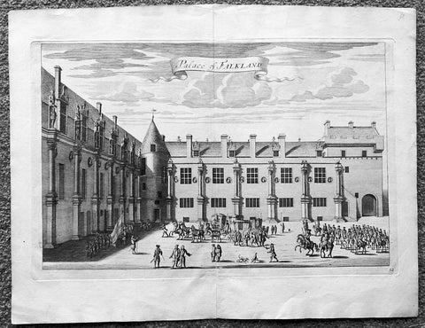
1718 Slezer Antique Print View of Falkland Palace, Fife, Scotland
- Title : Palace of Falkland
- Date : 1718
- Ref # : 24958
- Size : 18 ½in x 14 ½in (470mm x 360mm)
- Condition: (A+) Fine
Description:
This fine beautifully hand coloured original antique print a view of the internal courtyard of Falkland Palace, home of the Scottish Kings - was published in the 1718 edition of John Slezer's 'Theatrum Scotiae'.
Falkland Palace in Falkland, Fife, Scotland, is a former royal palace of the Scottish Kings. The Scottish Crown acquired Falkland Castle from MacDuff of Fife in the 14th century. In 1402 Robert Stewart, 1st Duke of Albany imprisoned his nephew David Stewart, Duke of Rothesay, the eldest son of King Robert III of Scotland, at Falkland. The incarcerated Duke eventually died there from neglect and starvation. Albany was exonerated from blame by Parliament, but suspicions of foul play persisted, suspicions which never left Rothesay's younger brother the future James I of Scotland, and which would eventually lead to the downfall of the Albany Stewarts. John Debrett, writing in 1805, was in no doubt of Duke Robert's motives and guilt. This Robert, Duke of Albany, having obtained the entire government from his brother, King Robert, he caused the Duke of Rothesay to be murdered, thinking to bring the Crown into his own family; but to avoid the like fate, King Robert resolved to send his younger son James, to France, then about nine years old, who being sea-sick, and forced to land on the English coast ... was detained a captive in England eighteen years. At these misfortunes King Robert died of grief in 1406. Between 1501 and 1541 Kings James IV and James V of Scotland transformed the old castle into a beautiful royal palace: with Stirling Castle it was one of only two Renaissance palaces in Scotland. To address the poor state of the garden and park, James V appointed a new Captain and Keeper, William Barclay, Master of Rhynd, in March 1527. Ten years later, James V extended his father's buildings in French renaissance style. He died at Falkland in December 1542 after hearing that his wife had given birth to a daughter—Mary, Queen of Scots. Falkland became a popular retreat with all the Stewart monarchs. They practised falconry there and used the vast surrounding forests for hawking and for hunting deer. Wild boar, imported from France, were kept in the Park, within a fence made by the Laird of Fernie. Nearby Myres Castle is the hereditary home of the Royal Macers and Sergeants at Arms who served Falkland Castle since at least the sixteenth century. John Scrimgeour of Myres supervised building at the Palace from 1532 to 1563. After the Union of the Crowns (1606), James VI and I, Charles I, and Charles II all visited Falkland. A fire partially destroyed the palace during its occupation by Cromwell's troops and it quickly fell into ruin.
This is an important and rare print as Slezer s Theatrum Scotiae is one of the earliest records of early Scottish towns & major buildings. (Ref: Tooley; M&B)
General Description:
Paper thickness and quality: - Heavy and stable
Paper color: - off white
Age of map color: -
Colors used: -
General color appearance: -
Paper size: - 18 ½in x 14 ½in (470mm x 360mm)
Plate size: - 16 ½in x 11in (420mm x 275mm)
Margins: - Min 1in (25mm)
Imperfections: Margins: - None
Plate area: - None
Verso: - None
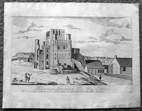
1718 Slezer Antique Print View of Kelso Abby & Township, Scotland
- Title : The Abby of Kelso
- Date : 1718
- Ref # : 24953
- Size : 18 ½in x 14 ½in (470mm x 360mm)
- Condition: (A+) Fine
Description:
This fine beautifully hand coloured original antique print a view of Kelso Abby & Kelso Town, Scotland was published in the 1718 edition of John Slezer's 'Theatrum Scotiae'.
Kelso Abbey is a ruined Scottish abbey in Kelso, Scotland. It was founded in the 12th century by a community of Tironensian monks first brought to Scotland in the reign of Alexander I. It occupies ground overlooking the confluence of the Tweed and Teviot waters, the site of what was once the Royal Burgh of Roxburgh and the intended southern centre for the developing Scottish kingdom at that time. Kelso thus became the seat of a pre-eminently powerful abbacy in the heart of the Scottish Borders.
In the 14th century, Roxburgh became a focus for periodic attack and occupation by English forces and Kelso's monastic community survived a number of fluctuations in control over the area, restoring the abbey infrastructure after episodes of destruction and ultimately retaining Scottish identity. From 1460 onwards, life for the abbey probably grew more settled, but came once again under attack in the early sixteenth century. By the mid-century, through a turbulent combination of events, the abbey effectively ceased to function and the building fell into ruin.
Although the site of Kelso Abbey has not been fully excavated in modern times, evidence suggests that it was a major building with two crossings. The only remains standing today are the west tower crossing and part of the infirmary. The massive design and solid romanesque style of the tower indicate a very large building of formidable, semi-military construction and appearance, evidence of the importance with which Roxburgh was regarded when the abbacy was at the height of its power.
This is an important and rare print as Slezer s Theatrum Scotiae is one of the earliest records of early Scottish towns & major buildings. (Ref: Tooley; M&B)
General Description:
Paper thickness and quality: - Heavy and stable
Paper color: - off white
Age of map color: -
Colors used: -
General color appearance: -
Paper size: - 18 ½in x 14 ½in (470mm x 360mm)
Plate size: - 16 ½in x 11in (420mm x 275mm)
Margins: - Min 1in (25mm)
Imperfections: Margins: - Light age toning
Plate area: - Light age toning
Verso: - Light age toning
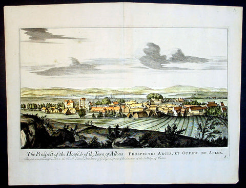
1693 Slezer Antique Print View of the Town of Alloa on Firth of Forth Scotland
- Title : The Prospect of the House & of the Town of Alloua
- Ref : 24947
- Size: 18 ½in x 14 ½in (470mm x 370mm)
- Date : 1693
- Condition: (A+) Fine Condition
Description:
This finely engraved original important antique print a view of the town of Alloa in Clackmannanshire in eastern Scotland on the Firth of Forth, was published in the first edition of John Slezer's 'Theatrum Scotiae', 1693.
This is an important and rare print as Slezer s Theatrum Scotiae is one of the earliest records of early Scottish towns. (Ref: Tooley; M&B)
General Description:
Paper thickness and quality: - Heavy and stable
Paper color: - off white
Age of map color: -
Colors used: -
General color appearance: -
Paper size: - 18 ½in x 14 ½in (470mm x 370mm)
Plate size: - 16 ½in x 11 in (420mm x 280mm)
Margins: - Min 1in (25mm)
Imperfections:
Margins: - None
Plate area: - None
Verso: - None
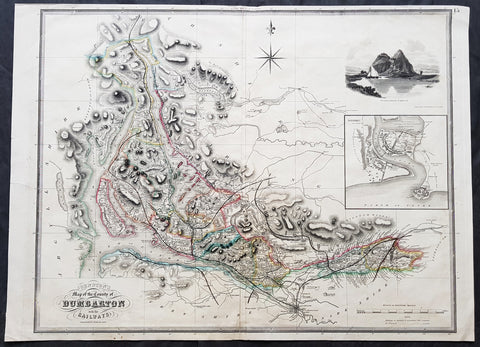
1841 Johnston Large Antique Map The County of Dumbarton, Dunbartonshire Scotland
- Title : 1841 Johnston Large Antique Map The County of Dumbarton, Dunbartonshire Scotland
- Size: 29in x 21in (740mm x 535mm)
- Condition: (A) Very Good Condition
- Date : 1841
- Ref #: 70481
Description:
This large original hand coloured steel-plate engraved antique map of the Scottish region of Dumbarton in the county of Dunbartonshire centering on Glasgow and the river Clyde - with an inset image of Dumbarton Castle and another of Dumbarton Town - was published by W & A.K. Johnston in 1841.
The map centers on Loch Lomond, the River Clyde and the city of Glasgow.
General Definitions:
Paper thickness and quality: - Heavy and stable
Paper color : - off white
Age of map color: - Original
Colors used: - Yellow, green, blue, pink
General color appearance: - Authentic
Paper size: - 29in x 21in (740mm x 535mm)
Plate size: - 27in x 21in (685mm x 535mm)
Margins: - Min 1/2in (12mm)
Imperfections:
Margins: - Soiling, several small repairs to margins into border, no loss
Plate area: - Light soiling, centerfold re-joined
Verso: - Soiling, repairs as noted
Background:
Dunbartonshire or the County of Dumbarton is a historic county, lieutenancy area and registration county in the west central Lowlands of Scotland lying to the north of the River Clyde.