Australia/Oceania (293)
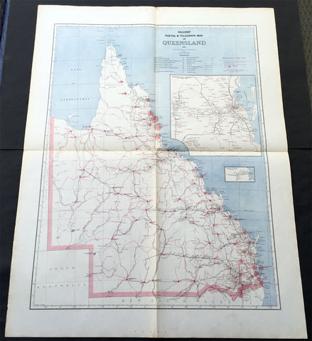
1888 Picturesque Atlas of Australia Large Antique Railway Map of Queensland
- Title : Railway Postal & Telegraph Map of Queensland
- Ref #: 50329
- Size: 34in x 26in (865mm x 660mm)
- Date : 1888
- Condition: (A+) Fine Condition
Description:
This very large fine original antique lithograph layered coloured map of Queensland showing the extent of Railway and postal lines, was engraved in 1888 - the date is engraved in the title - with index page - by Alex J Scally - was published in the extremely significant Australian & New Zealand publication The Picturesque Atlas of Australasia between 1886-88.
These maps were some of the best maps published at the time in the "Modern" look. The colour is bright, the engraving extremely fine and the paper heavy and stable.
General Description:
Paper thickness and quality: - Light & stable
Paper color: - White
Age of map color: - Original
Colors used: - Blue, red
General color appearance: - Authentic
Paper size: - 34in x 26in (865mm x 660mm)
Plate size: - 34in x 26in (865mm x 660mm)
Margins: - Min 1in (25mm)
Imperfections:
Margins: - None
Plate area: - Folds as issued
Verso: - None
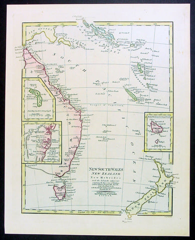
1808 Wilkinson Antique Map of East Coast of Australia, New Zealand, inset Sydney
- Title : New South Wales New Zealand New Hebrides...Published Dec 12th 1808
- Ref #: 9003
- Size: 13in x 11in (330mm x 280mm)
- Date : 1808
- Condition: (A+) Fine Condition
Description:
This fine beautifully hand coloured original antique map of the east coast of Australia, New Zealand and the Solomon Islands - with inset maps of Lord Howe Island, Norfolk Island & Port Jackson - was published in 1808 by Robert Wilkinson - the date is included in the title - in his wideley acclaimed General Atlas of the World published between 1794 and 1816.
This is a finely engraved copper-plate map with beautiful original hand colouring on strong stable paper. (Ref: Tooley; M&B)
General Description:
Paper thickness and quality: - Heavy and stable
Paper color: - off white
Age of map color: - Original
Colors used: - Yellow, green, pink, blue
General color appearance: - Authentic
Paper size: - 13in x 11in (330mm x 280mm)
Plate size: - 12 1/2in x 10in (320mm x 255mm)
Margins: - Min 1/2in (12mm)
Imperfections:
Margins: - None
Plate area: - None
Verso: - None
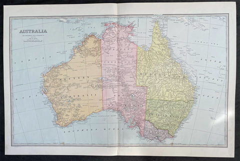
1888 Pic Atlas Scally Large Antique Map of Australia
- Title : Australia
- Date : 1888
- Condition: (A+) Fine Condition
- Ref: 31986
- Size: 25 1/2in x 17in (650mm x 430mm)
Description:
This large steel-plate engraved original antique lithograph map of Australia - engraved by Alex J Scally in 1888, dated at the foot of the map - was published in The Picturesque Atlas of Australasia, 1886-88. A beautiful large pre-federation antique map of Australia, highly detailed in fine condition.
General Description:
Paper thickness and quality: - Light & stable
Paper color: - White
Age of map color: - Original
Colors used: - Yellow, pink, green, blue
General color appearance: - Authentic
Paper size: - 25 1/2in x 17in (650mm x 430mm)
Margins: - Min 1in (25mm)
Imperfections:
Margins: - None
Plate area: - None
Verso: - None
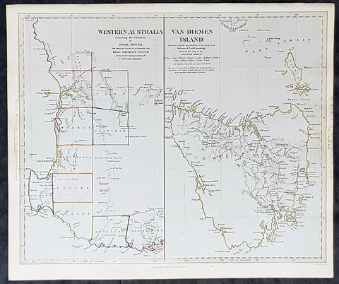
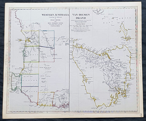
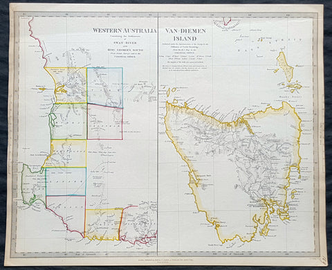
1833 SDUK Antique Map of Western Australia & Van Diemens Land, Tasmania
- Title : Western Australia containing the settlment of Swan River and King Georges Sound; Van-Diemens Land
- Size: 16 1/4in x 13 1/2in (410mm x 350mm)
- Condition: (A+) Fine Condition
- Date : 1833
- Ref #: 31973
Description:
This fine hand coloured original steel plate engraved antique maps of Western Australia - only 4 years after the first British settlement on the Swan river & Van Diemens Land or Tasmania was engraved by J & C Walker, in 1833 - the date is engraved at the foot of the map - and was published in the Baldwin & Craddock edition of the Society For the Diffusion of Useful Knowledge (SDUK) Atlas.
General Definitions:
Paper thickness and quality: - Heavy and stable
Paper color : - off white
Age of map color: - Original
Colors used: - Yellow, Green, pink
General color appearance: - Authentic
Paper size: - 16 1/4in x 13 1/2in (410mm x 350mm)
Plate size: - 16 1/4in x 13 1/2in (410mm x 350mm)
Margins: - Min 1/2in (12mm)
Imperfections:
Margins: - None
Plate area: - None
Verso: - None
Background:
The SDUK produced two landmark volumes of cartography in the first half of the 19th century. The first volume concentrated on areas of the old world, Europe, Africa, Great Britain etc. The second volume contained maps of the new world, Alvin Jewett JohnsonAmerica, South Asia, including US state maps, colonies of Australia, South Africa, South America etc. Also included were some of the finest engraved town and city plans published at that time.
The SDUK was published in its entirety or in part by many publishers including Baldwin and Cradock 1829-32, Chapman & Hall in 1844, Charles Knight & co. 1846 – 1852. G. Cox published the SDUK between 1852-3, Stanford 1857-70 and later revised edition were also published after Stanford. (Ref: Tooley, M&B)
1833 SDUK Antique Map of Western Australia & Van Diemens Land, Tasmania
- Title : Western Australia containing the settlment of Swan River and King Georges Sound; Van-Diemens Land
- Size: 16 1/4in x 13 1/2in (410mm x 350mm)
- Condition: (A+) Fine Condition
- Date : 1833
- Ref #: 24670
Description:
This fine hand coloured original steel plate engraved antique maps of Western Australia - only 4 years after the first British settlement on the Swan river & Van Diemens Land or Tasmania was engraved by J & C Walker, in 1833 - the date is engraved at the foot of the map - and was published in the Baldwin & Craddock edition of the Society For the Diffusion of Useful Knowledge (SDUK) Atlas.
General Definitions:
Paper thickness and quality: - Heavy and stable
Paper color : - off white
Age of map color: - Original
Colors used: - Yellow, Green, pink
General color appearance: - Authentic
Paper size: - 16 1/4in x 13 1/2in (410mm x 350mm)
Plate size: - 16 1/4in x 13 1/2in (410mm x 350mm)
Margins: - Min 1/2in (12mm)
Imperfections:
Margins: - None
Plate area: - None
Verso: - None
Background:
The SDUK produced two landmark volumes of cartography in the first half of the 19th century. The first volume concentrated on areas of the old world, Europe, Africa, Great Britain etc. The second volume contained maps of the new world, Alvin Jewett JohnsonAmerica, South Asia, including US state maps, colonies of Australia, South Africa, South America etc. Also included were some of the finest engraved town and city plans published at that time.
The SDUK was published in its entirety or in part by many publishers including Baldwin and Cradock 1829-32, Chapman & Hall in 1844, Charles Knight & co. 1846 – 1852. G. Cox published the SDUK between 1852-3, Stanford 1857-70 and later revised edition were also published after Stanford. (Ref: Tooley, M&B)
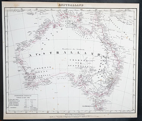
1845 Handtke & Flemming Large Antique Map of Australia - Population of 213,500
- Title : Australland...1841
- Date : 1845
- Condition: (A+) Fine Condition
- Ref: 40972
- Size: 16in x 14in (405mm x 355mm)
Description:
This hand coloured original steel-plate engraved antique highly detailed map of Australia, with a population census of the entire country in 1841, by Friedrich Handtke in 1845, was published in the Complete hand atlas of the recent description of the earth over all parts of the earth, Carl Flemming, Glougau.
General Definitions:
Paper thickness and quality: - Heavy and stable
Paper color : - off white
Age of map color: - Original
Colors used: - Yellow, red
General color appearance: - Authentic
Paper size: - 16in x 14in (405mm x 355mm)
Plate size: - 16in x 14in (405mm x 355mm)
Margins: - Min 1/2in (12mm)
Imperfections:
Margins: - Light spotting
Plate area: - Light spotting
Verso: - Light spotting
Background:
Australia is a sovereign country comprising the mainland of the Australian continent, the island of Tasmania and numerous smaller islands. It is the largest country in Oceania and the world\'s sixth-largest country by total area. The neighbouring countries are Papua New Guinea, Indonesia and East Timor to the north; the Solomon Islands and Vanuatu to the north-east; and New Zealand to the south-east. The population of 25 million is highly urbanised and heavily concentrated on the eastern seaboard. Australias capital is Canberra, and its largest city is Sydney. The country\'s other major metropolitan areas are Melbourne, Brisbane, Perth and Adelaide.
Australia was inhabited by indigenous Australians for about 60,000 years before the first British settlement in the late 18th century. It is documented that Aborigines spoke languages that can be classified into about 250 groups. After the European discovery of the continent by Dutch explorers in 1606, who named it New Holland, Australia\'s eastern half was claimed by Great Britain in 1770 and initially settled through penal transportation to the colony of New South Wales from 26 January 1788, a date which became Australia\'s national day. The population grew steadily in subsequent decades, and by the 1850s most of the continent had been explored and an additional five self-governing crown colonies established. On 1 January 1901, the six colonies federated, forming the Commonwealth of Australia. Australia has since maintained a stable liberal democratic political system that functions as a federal parliamentary constitutional monarchy comprising six states and ten territories.
Being the oldest, flattest and driest inhabited continent, with the least fertile soils, Australia has a landmass of 7,617,930 square kilometres. A megadiverse country, its size gives it a wide variety of landscapes, with deserts in the centre, tropical rainforests in the north-east and mountain ranges in the south-east. A gold rush began in Australia in the early 1850s, which boosted the population of the country. Nevertheless, its population density, 2.8 inhabitants per square kilometre, remains among the lowest in the world. Australia generates its income from various sources including mining-related exports, telecommunications, banking and manufacturing. Indigenous Australian rock art is the oldest and richest in the world, dating as far back as 60,000 years and spread across hundreds of thousands of sites.
The first recorded European sighting of the Australian mainland, and the first recorded European landfall on the Australian continent (in 1606), are attributed to the Dutch. The first ship and crew to chart the Australian coast and meet with Aboriginal people was the Duyfken captained by Dutch navigator, Willem Janszoon. He sighted the coast of Cape York Peninsula in early 1606, and made landfall on 26 February at the Pennefather River near the modern town of Weipa on Cape York. The Dutch charted the whole of the western and northern coastlines and named the island continent New Holland during the 17th century, but made no attempt at settlement. William Dampier, an English explorer and privateer, landed on the north-west coast of New Holland in 1688 and again in 1699 on a return trip. In 1770, James Cook sailed along and mapped the east coast, which he named New South Wales and claimed for Great Britain.
With the loss of its American colonies in 1783, the British Government sent a fleet of ships, the First Fleet, under the command of Captain Arthur Phillip, to establish a new penal colony in New South Wales. A camp was set up and the flag raised at Sydney Cove, Port Jackson, on 26 January 1788, a date which became Australia\'s national day, Australia Day. A British settlement was established in Van Diemens Land, now known as Tasmania, in 1803, and it became a separate colony in 1825. The United Kingdom formally claimed the western part of Western Australia (the Swan River Colony) in 1828. Separate colonies were carved from parts of New South Wales: South Australia in 1836, Victoria in 1851, and Queensland in 1859. The Northern Territory was founded in 1911 when it was excised from South Australia. South Australia was founded as a free province—it was never a penal colony. Victoria and Western Australia were also founded free, but later accepted transported convicts. A campaign by the settlers of New South Wales led to the end of convict transportation to that colony; the last convict ship arrived in 1848.
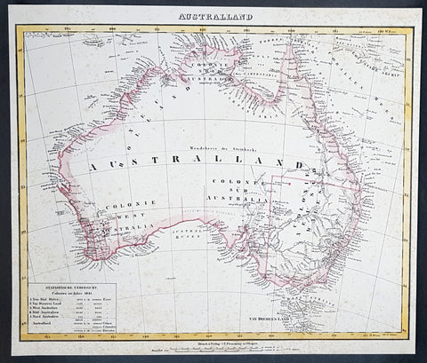
1845 Handtke & Flemming Large Antique Map of Australia - Population of 213,500
- Title : Australland...1841
- Date : 1845
- Condition: (A) Very Good Condition
- Ref: 31977
- Size: 16in x 14in (405mm x 355mm)
Description:
This hand coloured original steel-plate engraved antique highly detailed map of Australia, with a population census of the entire country in 1841, by Friedrich Handtke in 1845, was published in the Complete hand atlas of the recent description of the earth over all parts of the earth, Carl Flemming, Glougau.
General Definitions:
Paper thickness and quality: - Heavy and stable
Paper color : - off white
Age of map color: - Original
Colors used: - Yellow, red
General color appearance: - Authentic
Paper size: - 16in x 14in (405mm x 355mm)
Plate size: - 16in x 14in (405mm x 355mm)
Margins: - Min 1/2in (12mm)
Imperfections:
Margins: - Age toning & spotting
Plate area: - Age toning & spotting
Verso: - Age toning & spotting
Background:
Australia is a sovereign country comprising the mainland of the Australian continent, the island of Tasmania and numerous smaller islands. It is the largest country in Oceania and the world\'s sixth-largest country by total area. The neighbouring countries are Papua New Guinea, Indonesia and East Timor to the north; the Solomon Islands and Vanuatu to the north-east; and New Zealand to the south-east. The population of 25 million is highly urbanised and heavily concentrated on the eastern seaboard. Australias capital is Canberra, and its largest city is Sydney. The country\'s other major metropolitan areas are Melbourne, Brisbane, Perth and Adelaide.
Australia was inhabited by indigenous Australians for about 60,000 years before the first British settlement in the late 18th century. It is documented that Aborigines spoke languages that can be classified into about 250 groups. After the European discovery of the continent by Dutch explorers in 1606, who named it New Holland, Australia\'s eastern half was claimed by Great Britain in 1770 and initially settled through penal transportation to the colony of New South Wales from 26 January 1788, a date which became Australia\'s national day. The population grew steadily in subsequent decades, and by the 1850s most of the continent had been explored and an additional five self-governing crown colonies established. On 1 January 1901, the six colonies federated, forming the Commonwealth of Australia. Australia has since maintained a stable liberal democratic political system that functions as a federal parliamentary constitutional monarchy comprising six states and ten territories.
Being the oldest, flattest and driest inhabited continent, with the least fertile soils, Australia has a landmass of 7,617,930 square kilometres. A megadiverse country, its size gives it a wide variety of landscapes, with deserts in the centre, tropical rainforests in the north-east and mountain ranges in the south-east. A gold rush began in Australia in the early 1850s, which boosted the population of the country. Nevertheless, its population density, 2.8 inhabitants per square kilometre, remains among the lowest in the world. Australia generates its income from various sources including mining-related exports, telecommunications, banking and manufacturing. Indigenous Australian rock art is the oldest and richest in the world, dating as far back as 60,000 years and spread across hundreds of thousands of sites.
The first recorded European sighting of the Australian mainland, and the first recorded European landfall on the Australian continent (in 1606), are attributed to the Dutch. The first ship and crew to chart the Australian coast and meet with Aboriginal people was the Duyfken captained by Dutch navigator, Willem Janszoon. He sighted the coast of Cape York Peninsula in early 1606, and made landfall on 26 February at the Pennefather River near the modern town of Weipa on Cape York. The Dutch charted the whole of the western and northern coastlines and named the island continent New Holland during the 17th century, but made no attempt at settlement. William Dampier, an English explorer and privateer, landed on the north-west coast of New Holland in 1688 and again in 1699 on a return trip. In 1770, James Cook sailed along and mapped the east coast, which he named New South Wales and claimed for Great Britain.
With the loss of its American colonies in 1783, the British Government sent a fleet of ships, the First Fleet, under the command of Captain Arthur Phillip, to establish a new penal colony in New South Wales. A camp was set up and the flag raised at Sydney Cove, Port Jackson, on 26 January 1788, a date which became Australia\'s national day, Australia Day. A British settlement was established in Van Diemens Land, now known as Tasmania, in 1803, and it became a separate colony in 1825. The United Kingdom formally claimed the western part of Western Australia (the Swan River Colony) in 1828. Separate colonies were carved from parts of New South Wales: South Australia in 1836, Victoria in 1851, and Queensland in 1859. The Northern Territory was founded in 1911 when it was excised from South Australia. South Australia was founded as a free province—it was never a penal colony. Victoria and Western Australia were also founded free, but later accepted transported convicts. A campaign by the settlers of New South Wales led to the end of convict transportation to that colony; the last convict ship arrived in 1848.
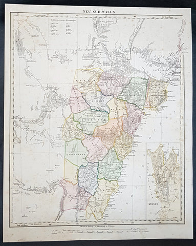
1854 Handtke & Flemming Large Antique Map of New South Wales, Sydney, Australia
- Title : Neu Sud-Wales
- Date : 1854
- Condition: (A) Very Good Condition
- Ref: 31992
- Size: 17in x 14in (430mm x 355mm)
Description:
This beautifully hand coloured original steel-plate engraved antique map of New South Wales, with an inset of a plan of Sydney Town by Friedrich Handtke in 1854, was published in the Complete hand atlas of the recent description of the earth over all parts of the earth, Carl Flemming, Glougau.
General Definitions:
Paper thickness and quality: - Heavy and stable
Paper color : - off white
Age of map color: - Original
Colors used: - Yellow, green, blue, pink
General color appearance: - Authentic
Paper size: - 17in x 14in (430mm x 355mm)
Plate size: - 17in x 14in (430mm x 355mm)
Margins: - Min 1/2in (12mm)
Imperfections:
Margins: - Light age toning
Plate area: - Light age toning
Verso: - Light age toning
Background:
A golden age of a new kind began in New South Wales and Sydney in 1851 with the announcement of the discovery of payable gold at Ophir near Bathurst by Edward Hargraves. In that year New South Wales had about 200,000 people, a third of them within a days ride of Sydney, the rest scattered along the coast and through the pastoral districts, from the Port Phillip District in the south to Moreton Bay in the north. The gold rushes of the 1850s brought a huge influx of settlers, although initially the majority of them went to the richest gold fields at Ballarat and Bendigo, in the Port Phillip District, which in 1851 was separated to become the colony of Victoria.
Hill End, also near Bathurst N.S.W. was a locality that grew, boomed and faded with the N.S.W. Gold Rush. Called \'Bald Hills\' in 1850, \'Forbes in 1860 and finally Hill End in 1862, it was part of the Tambaroora district. At its peak, its population was 7,000. Completely reliant on mining, the town\'s decline was dramatic once the gold ran out. Hill End is famed for the unearthing of the Holtermann Specimen (correctly, the Beyers Holtermann Specimen), being the largest single mass of gold ever discovered in the world, a record that stands today. Found in 1872 at the Star Hope Mine, this single mass of quartz and gold weighed 630 lbs and when crushed produced an estimated 3,000 troy oz (205 lbs or 93 kg) of gold, thus holding more processed gold than from the largest nugget ever found, that being the Welcome Stranger from the Victorian Goldfields. Holtermann recognizing the significance of the find attempted to preserve it by buying it from the Company of which he was one of a number of directors. His efforts were in vain. It is reported that a larger mass was discovered a few days later in the same mine but was broken up underground.
Victoria soon had a larger population than New South Wales, and its upstart capital, Melbourne, outgrew Sydney. But the New South Wales gold fields also attracted a flood of prospectors, and by 1857 the colony had more than 300,000 people. Inland towns like Bathurst, Goulburn, Orange and Young flourished. Gold brought great wealth but also new social tensions. Multiethnic migrants came to New South Wales in large numbers for the first time. Young became the site of an infamous anti-Chinese miner riot in 1861 and the official Riot Act was read to the miners on 14 July – the only official reading in the history of New South Wales.[27] Despite some tension, the influx of migrants also brought fresh ideas from Europe and North America to New South Wales – Norwegians introduced Skiing in Australia to the hills above the Snowy Mountains gold rush town of Kiandra around 1861. A famous Australian son was also born to a Norwegian miner in 1867, when the bush balladeer Henry Lawson was born at the Grenfell goldfields.
In 1858, a new gold rush began in the far north, which led in 1859 to the separation of Queensland as a new colony. New South Wales thus attained its present borders, although what is now the Northern Territory remained part of the colony until 1863, when it was handed over to South Australia.
The separation and rapid growth of Victoria and Queensland mark the real beginning of New South Wales as a political and economic entity distinct from the other Australian colonies. Rivalry between New South Wales and Victoria was intense throughout the second half of the 19th century, and the two colonies developed in radically different directions. Once the easy gold ran out by about 1860, Victoria absorbed the surplus labour force from the gold fields in manufacturing, protected by high tariff walls. Victoria became the Australian stronghold of protectionism, liberalism and radicalism. New South Wales, which was less radically affected demographically by the gold rushes, remained more conservative, still dominated politically by the squatter class and its allies in the Sydney business community. New South Wales, as a trading and exporting colony, remained wedded to free trade.
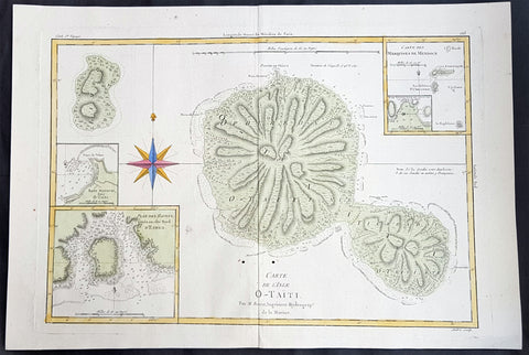
1780 Rigobert Bonne Large Antique Map of Tahiti
- Title : Carte De L 'Isle O - Taiti...Par M. Bonne...
- Date : 1780
- Condition: (A) Very Good Condition
- Ref: 40570
- Size: 15in x 11in (400mm x 275mm)
Description:
This fine original copper plate engraved antique map by Rigobert Bonne was published in the 1780 edition of Atlas des toutes les parties connues du globe terrestre by Guillaume Raynal. (Ref Tooley M&B)
General Definitions:
Paper thickness and quality: - Heavy and stable
Paper color : - off white
Age of map color: - Early
Colors used: - Yellow, Green, pink
General color appearance: - Authentic
Paper size: - 16 ½in x 11 ½in; (420mm x 295mm)
Plate size: - 14 ½in x 10in; (370mm x 250mm)
Margins: - Min 1/2in (12mm)
Imperfections:
Margins: - None
Plate area: - Two very small worm holes adjacent to bottom centerfold
Verso: - None
Background:
Tahiti previously also known as Otaheite is the largest island in the Windward group of French Polynesia. The island is located in the archipelago of the Society Islands in the central Southern Pacific Ocean.
The first European to have visited Tahiti according to existing records was lieutenant Samuel Wallis, who was circumnavigating the globe in HMS Dolphin, sighting the island on 18 June 1767, and eventually harboring in Matavai Bay. This bay was situated on the territory of the chiefdom of Pare-Arue, governed by Tu (Tu-nui-e-a a-i-te-Atua) and his regent Tutaha, and the chiefdom of Ha apape, governed by Amo and his wife Oberea (Purea). Wallis named the island King Georges Island. The first contacts were difficult, since on the 24 and 26 June 1767, Tahitian warriors in canoes showed aggression towards the British, hurling stones from their slings. In retaliation, the British sailors opened fire on the warriors in the canoes and on the hills. In reaction to this powerful counter-attack, the Tahitians laid down peace offerings for the British. Following this episode, Samuel Wallis was able to establish cordial relations with the female chieftain “Oberea “ (Purea) and remained on the island until 27 July 1767.
In July 1768, Captain James Cook was commissioned by the Royal Society and on orders from the Lords Commissioners of the Admiralty to observe the transit of Venus across the sun, a phenomenon that would be visible from Tahiti on 3 June 1769. He arrived in Tahitis Matavai Bay, commanding the HMS Endeavour on 12 April 1769. On 14 April, Cook met with Tutaha and Tepau. On 15 April, Cook picked the site for a fortified camp at Point Venus along with Banks, Parkinson, Daniel Solander, to protect Charles Greens observatory. The length of stay enabled them to undertake for the first time real ethnographic and scientific observations of the island. Assisted by the botanist Joseph Banks, and by the artist Sydney Parkinson, Cook gathered valuable information on the fauna and flora, as well as the native society, language and customs, including the proper name of the island, Otaheite. On 28 April, Cook met Purea and Tupaia, and Tupaia befriended Banks following the transit. On 21 June, Amo visited Cook, and then on 25 June, Pohuetea visited, signifying another chief seeking to ally himself with the British.
Cook and Banks circumnavigated the island from 26 June to 1 July. On the exploration, they met Ahio, chief of Ha apaiano o or Papenoo, Rita, chief of Hitia a, Pahairro, chief of Pueu, Vehiatua, chief of Tautra, Matahiapo, chief of Teahupo o, Tutea, chief of Vaira o, and Moe, chief of Afa Ahiti. In Papara, guided by Tupaia, they investigated the ruins of Mahaiatea marae, an impressive structure containing a stone pyramid or ahu, measuring 44 feet high, 267 feet long and 87 feet wide. Cook and the Endeavour departed Tahiti on 13 July 1769, taking Raiatean navigator Tupaia along for his geographic knowledge of the islands.
Cook returned to Tahiti between 15 August and 1 September 1773, greeted by the chiefs Tai and Puhi, besides the youg ari i Vehiatua II and his stepfather Ti itorea. Cook anchored in Vaitepiha Bay before returning to Point Venus where he met Tu, the paramount chief. Cook picked up two passengers from Tahiti during this trip, Porea and Mai, with Hitihiti later replacing Porea when Cook stopped at Raiatea. Cook took Hitihiti to Tahiti on 22 April, during his return leg. Then, Cook departed Tahiti on 14 May 1774.
During his final visit, Cook returned Mai to Tahiti on 12 Aug. 1777, after Mais long visit in England. Cook also brought two Maori from Queen Charlotte Sound, Te Weherua and Koa. Cook first harbored in Vaitepiha Bay, where he visited Vehiatua II s funeral bier and the prefabricated Spanish mission house. Cook also met Vehiatua III, and inscribed on the back of the Spanish cross, Georgius tertius Rex Annis 1767, 69, 73, 74 & 77, as a counterpoint to Christus Vincit Carolus III imperat 1774 on the front. On 23 Aug., Cook sailed for Matavai Bay, where he met Tu, his father Teu, his mother Tetupaia, his brothers Ari ipaea and Vaetua, and his sisters Ari ipaea-vahine, Tetua-te-ahamai, and Auo. Cook also observed a human sacrifice, taata tapu, at the Utu-ai-mahurau marae, and 49 skulls from previous victims.
On 29 Sept. 1777, Cook sailed for Papetoai Bay on Moorea. Cook met Mahine in an act of friendship on 3 Oct., though he was an enemy of Tu. When a goat kid was stolen on 6 Oct., Cook in a rampage, ordered the burning of houses and canoes until it was returned. Cook sailed for Huahine on 11 Oct., Raiatea on 2 Nov., and Borabora on 7 Dec.
On 26 October 1788, HMS Bounty, under the command of Captain William Bligh, landed in Tahiti with the mission of carrying Tahitian breadfruit trees (Tahitian: uru) to the Caribbean. Sir Joseph Banks, the botanist from James Cooks first expedition, had concluded that this plant would be ideal to feed the African slaves working in the Caribbean plantations at very little cost. The crew remained in Tahiti for about five months, the time needed to transplant the seedlings of the trees. Three weeks after leaving Tahiti, on 28 April 1789, the crew mutinied on the initiative of Fletcher Christian. The mutineers seized the ship and set the captain and most of those members of the crew who remained loyal to him adrift in a ships boat. A group of mutineers then went back to settle in Tahiti.
Although various explorers had refused to get involved in tribal conflicts, the mutineers from the Bounty offered their services as mercenaries and furnished arms to the family which became the Pōmare Dynasty. The chief Tū knew how to use their presence in the harbours favoured by sailors to his advantage. As a result of his alliance with the mutineers, he succeeded in considerably increasing his supremacy over the island of Tahiti.
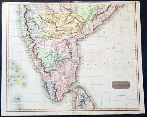
1816 John Thomson Large Antique Map of Southern India & Northern Sri Lanka
- Title : Southern Hindostan....Drawn & Engraved for Thomsons New General Atlas, 1816
- Date : 1816
- Size: 25in x 20 1/2in (635mm x 520mm)
- Condition: (A+) Fine Condition
- Ref: 41004
Description:
This large magnificent original hand coloured copper-plate engraved antique map of South India & northern Sri Lanka by John Thomson was engraved by Samuel Neele in 1816 - dated at the foot of the map - and was published in the 1817 edition of Thomsons New General Atlas
General Definitions:
Paper thickness and quality: - Heavy and stable
Paper color : - off white
Age of map color: - Original
Colors used: - Yellow, green, blue, pink
General color appearance: - Authentic
Paper size: - 25in x 20 1/2in (635mm x 520mm)
Plate size: - 25in x 20 1/2in (635mm x 520mm)
Margins: - Min 1/2in (15mm)
Imperfections:
Margins: - Top margin soiling and cropped to plate-mark
Plate area: - None
Verso: - None
Background:
The cartography of India begins with early charts for navigation and constructional plans for buildings. Indian traditions influenced Tibetan and Islamic traditions, and in turn, were influenced by the British cartographers who solidified modern concepts into India\'s map making
A prominent foreign geographer and cartographer was Hellenistic geographer Ptolemy (90–168) who researched at the library in Alexandria to produce a detailed eight-volume record of world geography. During the Middle Ages, India sees some exploration by Chinese and Muslim geographers, while European maps of India remain very sketchy. A prominent medieval cartographer was Persian geographer Abu Rayhan Biruni (973–1048) who visited India and studied the country\'s geography extensively.
European maps become more accurate with the Age of Exploration and Portuguese India from the 16th century. The first modern maps were produced by Survey of India, established in 1767 by the British East India Company. Survey of India remains in continued existence as the official mapping authority of the Republic of India.
1833 SDUK Antique Map of Western Australia, Swan River Colony & Van Diemens Land
- Title : Western Australia containing the settlment of Swan River and King Georges Sound; Van-Diemens Land
- Size: 16in x 14in (410mm x 355m)
- Condition: (A+) Fine Condition
- Date : 1833
- Ref #: 31974
Description:
This fine hand coloured original antique map of Western Australia - only 4 years after the first British settlement on the Swan river & Van Diemens Land or Tasmania was engraved by J & C Walker, in 1833 - the date is engraved at the foot of the map - and was published in the Baldwin & Craddock edition of the Society For the Diffusion of Useful Knowledge (SDUK) Atlas.
General Definitions:
Paper thickness and quality: - Heavy and stable
Paper color : - off white
Age of map color: - Original
Colors used: - Red, pink
General color appearance: - Authentic
Paper size: - 16in x 14in (410mm x 355m)
Plate size: - 16in x 14in (410mm x 355m)
Margins: - Min 1/2in (10mm)
Imperfections:
Margins: - Light age toning
Plate area: - None
Verso: - None
Background:
The SDUK produced two landmark volumes of cartography in the first half of the 19th century. The first volume concentrated on areas of the old world, Europe, Africa, Great Britain etc. The second volume contained maps of the new world, America, South Asia, including US state maps, colonies of Australia, South Africa, South America etc. Also included were some of the finest engraved town and city plans published at that time.
The SDUK was published in its entirety or in part by many publishers including Baldwin and Cradock 1829-32, Chapman & Hall in 1844, Charles Knight & co. 1846 – 1852. G. Cox published the SDUK between 1852-3, Stanford 1857-70 and later revised edition were also published after Stanford. (Ref: Tooley, M&B)
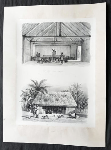
1842 D Urville & Le Breton Antique Print Church & Chief Tupou I Hut Vavau, Tonga
- Title : Interieur D un Temple: Habitation D un Chef (Isle Vavao)
- Size: 21in x 15in (535mm x 380mm)
- Condition: (A+) Fine Good Condition
- Date : 1842
- Ref #: 31750
Description:
This magnificent, large original antique lithograph print of the interior of the Protestant Church & Chief George Tupou I Hut both on the Tongan Island of Vavau , visited in October 1838 by Dumont D Urville in the ship The Astrolabe, was drawn by Louis Le Breton, asst. surgeon & artist/draftsman aboard the Astrolabe, during D Urvilles second voyage to the South Seas between 1837 - 1840, was engraved by Pharamond Blanchard and was published in the 1842 1st edition of Dumont d Urvilles Voyage au Pole Sud et dans l Océanie sur les corvettes l Astrolabe et la Zélée : Exécuté par ordre du roi pendant les années 1837-1838-1839-1840.
These large magnificent lithographs from the 1st edition are extremely hard to find, most only found in museums or in private hands, and due to the artistry are a must for any collection.
Louis Le Breton 1818 – 1866 was a French painter who specialised in marine paintings.
Le Breton studied medicine and took part in Dumont d Urville\'s second voyage aboard the Astrolabe. After the official illustrator of the expedition, Goupil, died, Le Breton replaced him.
From 1847 he devoted himself mainly to depicting marine subjects for the French Navy.
General Definitions:
Paper thickness and quality: - Heavy and stable
Paper color : - off white
Age of map color: -
Colors used: -
General color appearance: -
Paper size: - 21in x 15in (535mm x 380mm)
Plate size: - 21in x 15in (535mm x 380mm)
Margins: - Min 2in (50mm)
Imperfections:
Margins: - None
Plate area: - None
Verso: - None
Background:
Vavau is the island group of one large island (Utu Vavau) and 40 smaller ones in Tonga. It is part of Vavau District which includes several other individual islands. According to tradition the Maui god fished up both Tongatapu and Vavau but put a little more effort into the former. Vavau rises 204 metres (669 ft) above sea level at Mount Talau. The capital is Neiafu, which is the fifth largest city in Tonga, situated at the Port of Refuge (Puatalefusi or Lolo-a-Halaevalu).
Don Francisco Mourelle de la Rúa, commanding Spanish frigate Princesa was the first European to come to Vavau, on 4 March 1781. He charted Vavau as Martín de Mayorga who was the Viceroy of New Spain at the time. Captain James Cook knew about the islands a decade before, but the people in Haapai told him it would be no good for him to go there as there was no harbour. Apparently they did not want him to go there, and Cook heeded their advice anyway.
But Mourelle found excellent anchoring, of which he was in desperate need after having failed on Fonualei (Bitterness island) and Late, and he gave the spot the name Port of Refuge. But his original Port of Refuge was the bay on the west coast of the main island, near Longomapu. In 1793 Alessandro Malaspina visited for a month, following up on Mourelle and claiming the islands for Spain.
Tuʻi Tonga George Tupou I instituted the Vavau Code in Vavaʻu in 1839.
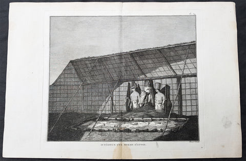
1785 Capt Cook Antique Print Statues in a Heiau, Island of Kauai Hawaii in 1778
- Title : Interieur D Un Morais D Atooi (Interior of a Morais in Atooi)
- Size: 16in x 10in (405mm x 260mm)
- Ref #: 21478
- Date : 1785
- Condition: (A+) Fine Condition
Description:
This fine original copper-plate engraved antique print of statues inside of a Hawaiian Heiau - temple - on the Island of Kauai (Atooi) Hawaii, visited by Captain Cook in 1778, during his 3rd & last Voyage of Discovery, was engraved by Robert Benard - after John Webber - and was published in the 1785 French edition of Capt. James Cook & Capt. James King publication A Voyage to the Pacific Ocean. Undertaken, by the Command of his Majesty, for making Discoveries in the Northern Hemisphere. To determine The Position and Extent of the West Side of North America; its Distance from Asia; and the Practicability of a Northern Passage to Europe. Performed under the direction of Captains Cook, Clerke, and Gore, In His Majestys Ships the Resolution and Discovery. In the Years 1776, 1777, 1778, 1779, and 1780. In Three Volumes. Vol. I and II written by James Cook, F.R.S. Vol. III by Captain James King, LL.D. and F.R.S. Paris, 1785.
Captain Cook arrived at Atooi (Kauai) on 19th January 1778 and stayed until 23rd January 1778.
On the 21st January, Cook accompanied by John Webber, proceeded inland from their beach side anchorage to Waimea, on the south coast of Kauai. Their intention was to examine elevated objects visible from the ship. It proved to be a morai, or temple similar to ones they had seen in Tahiti and other South Pacific islands. This structure was nearly 20-feet high and covered in a thin, light-grey cloth, which likely had ceremonial significance. The temple rested on a platform and consisted of thousands of rough-edged lava rock piled in a tight, mortarless fashion. In the center is the spindly-legged oracle tower, where the priest (kahuna) might seek counsel or pray. Carved figures with tapa and leaf offerings are seen outside thatched huts topped with pili, the tall grass that grew throughout the lowlands. In his journal, Cook took particular note of several stone objects he had observed:
...........about the middle of the Morai, there were three of these places in line. We were told three chiefs had been buried there, and before them was another that was oblong. This they called Tanga (taboo or kapu in Hawaiian) and gave us clearly to understand that three human sacrifices had been buried there, that is, one at the burial of each chief. Cooks Journals - January 21, 1778
General Definitions:
Paper thickness and quality: - Heavy and stable
Paper color : - off white
Age of map color: -
Colors used: -
General color appearance: -
Paper size: - 16in x 10in (405mm x 260mm)
Plate size: - 11in x 9 1/2in (280mm x 245mm)
Margins: - Min 1/2in (12mm)
Imperfections:
Margins: - Light soiling
Plate area: - None
Verso: - Light soiling
Background:
Kauai is geologically the oldest of the main Hawaiian Islands.
In 1778, Captain James Cook arrived at Waimea Bay, the first European known to have reached the Hawaiian islands. He named the archipelago after his patron the 6th Earl of Sandwich, George Montagu
Hawaii is the 50th and most recent state to have joined the United States of America, having received statehood on August 21, 1959. Hawaii is the only U.S. state located in Oceania and the only one composed entirely of islands. It is the northernmost island group in Polynesia, occupying most of an archipelago in the central Pacific Ocean. Hawaii is the only U.S. state located outside North America.
It is possible that Spanish explorers arrived in the Hawaiian Islands in the 16th century—200 years before Captain James Cook\\\'s first documented visit in 1778. Ruy López de Villalobos commanded a fleet of six ships that left Acapulco in 1542 bound for the Philippines with a Spanish sailor named Juan Gaetano aboard as pilot. Depending on the interpretation, Gaetanos reports describe an encounter with either Hawaii or the Marshall Islands. If de Villalobos crew spotted Hawaii, Gaetano would be considered the first European to see the islands. Some scholars have dismissed these claims due to a lack of credibility.
Spanish archives contain a chart that depicts islands at the same latitude as Hawaii but with a longitude ten degrees east of the islands. In this manuscript, the island of Maui is named La Desgraciada (The Unfortunate Island), and what appears to be Hawaii Island is named La Mesa (The Table). Islands resembling Kahoolawe, Lanai, and Molokai are named Los Monjes (The Monks). For two-and-a-half centuries, Spanish galleons crossed the Pacific from Mexico along a route that passed south of Hawaii on their way to Manila. The exact route was kept secret to protect the Spanish trade monopoly against competing powers.
The 1778 arrival of British explorer James Cook was the first documented contact by a European explorer with Hawaii. Cook named the archipelago as the Sandwich Islands in honor of his sponsor John Montagu, 4th Earl of Sandwich. Cook published the islands location and rendered the native name as Owyhee. This spelling lives on in Owyhee County, Idaho. It was named after three native Hawaiian members of a trapping party who went missing in that area. The Owyhee Mountains were also named for them
Cook visited the Hawaiian Islands twice. As he prepared for departure after his second visit in 1779, a quarrel ensued as Cook took temple idols and fencing as firewood and a minor chief and his men took a ship\\\'s boat. Cook abducted the King of Hawaii Island, Kalani ōpu u, and held him for ransom aboard his ship in order to gain return of Cook\\\'s boat. This tactic had worked in Tahiti and other islands. Instead, Kalani ōpu u s supporters fought back, killing Cook and four marines as Cooks party retreated along the beach to their ship. They departed without the ships boat.
Captain James King FRS 1750 – 1784 was an officer of the Royal Navy. He served under James Cook on his last voyage around the world, specialising in taking important astronomical readings using a sextant. After Cook died he helped lead the ships on the remainder of their course, also completing Cooks account of the voyage. He continued his career in the Navy, reaching the rank of post-captain, commanding several ships and serving in the American War of Independence.
King joined HMS Resolution as second lieutenant, sharing the duties of astronomer with Cook, taking astronomical observations on board by sextant and with Larcum Kendals timekeeper K1, to establish the Resolutions position at sea and on shore by sextant or by astronomical quadrant to establish the geographical position of salient points during the course of Cooks surveys. Thus Kings geographical positions were an important contribution to the accuracy of the various surveys carried out during the voyage and his use of the early chronometers helped prove their use at sea for calculation of Longitude. .
Following the death of Cook, King remained in the Resolution but on the death of Charles Clerke, Cooks successor, King was appointed to command HMS Discovery, the Resolutions consort, remaining in her for the rest of the voyage. After his return to England King was very much involved in the publication of the official account of Cooks third voyage, writing the third volume at Woodstock, near Oxford, where his brother Thomas was rector of St Mary Magdalene. But shortly after his return King was promoted Post-captain and appointed commander of HMS Crocodile in the English Channel.
John Webber RA 1751 – 1793 was an English artist who accompanied Captain Cook on his third Pacific expedition. He is best known for his images of Australasia, Hawaii and Alaska.
Webber was born in London, educated in Bern and studied painting at Paris.His father was Abraham Wäber, a Swiss sculptor who had moved to London, and changed his name to Webber before marrying a Mrs Mary Quant in 1744.
Webber served as official artist on James Cooks third voyage of discovery around the Pacific (1776–80) aboard HMS Resolution. At Adventure Bay in January 1777 he did drawings of A Man of Van Diemens Land and A Woman of Van Diemens Land. He also did many drawings of scenes in New Zealand and the South Sea islands. On this voyage, during which Cook lost his life in a fight in Hawaii, Webber became the first European artist to make contact with Hawaii, then called the Sandwich Islands. He made numerous watercolor landscapes of the islands of Kauai and Hawaii, and also portrayed many of the Hawaiian people.
In April 1778, Captain Cooks ships Resolution and Discovery anchored at Ship Cove, now known as Nootka Sound, Vancouver Island, Canada to refit. The crew took observations and recorded encounters with the local people. Webber made watercolour landscapes including Resolution and Discovery in Ship Cove, 1778. His drawings and paintings were engraved for British Admiraltys account of the expedition, which was published in 1784.
Back in England in 1780 Webber exhibited around 50 works at Royal Academy exhibitions between 1784 and 1792, and was elected an associate of the Royal Academy in 1785 and R.A. in 1791. Most of his work were landscapes. Sometimes figures were included as in A Party from H.M.S. Resolution shooting sea horses, which was shown at the academy in 1784, and his The Death of Captain Cook became well known through an engraving of it. Another version of this picture is in the William Dixson gallery at Sydney
Robert Bénard 1734 – 1777 was an 18th-century French engraver.
Specialized in the technique of engraving, Robert Ménard is mainly famous for having supplied a significant amount of plates (at least 1,800) to the Encyclopédie by Diderot & d Alembert from 1751.
Later, publisher Charles-Joseph Panckoucke reused many of his productions to illustrate the works of his catalog.
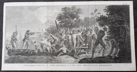
1778 Capt Cook Antique Print Crew & Marines Landing Erromango Isle Vanuatu, 1774
- Title : Debarquement A Erramanga, Lune Des Nouvelles Hebrides (Landing at Erramanga, of the new Hebrides)
- Size: 19in x 10in (485mm x 255mm)
- Ref #: 31828
- Date : 1778
- Condition: (A) Very Good Condition
Description:
This large original copper-plate engraved antique print of crew and Marines of HMS Resolution landing on the Island of Erromango - with Resolution in the background - an island in the Vanuatu (New Hebrides) group of Islands, visited by Captain James Cook in 1774, during his 2nd Voyage of Discovery to the South Seas, was engraved by Robert Benard - after William Hodges - and was published in the 1778 French edition of Capt. James Cooks 2nd Voyage of Discovery to the South Seas A voyage towards the South Pole, and round the World. Performed in His Majestys ships the Resolution and Adventure, in the years 1772, 1773, 1774, and 1775..... Paris : Hotel de Thou ......1778.
(August 1774)............on 2nd they looked for an anchorage down the west coast, the next day down the east coast, finally anchoring on 4th. Cook went with two boats to view the coast and to look for a proper landing place, wood and Water. At \"a Sandy Beach, where I could step out of the boat without weting a foot [he] landed in the face of a great Multitude with nothing but a green branch in my hand... I was received very courteously... in short I was charmed with thier behavour\". Soon, however, he had to give orders to fire as they now began to Shoot their Arrows and throw darts and Stones at us, the first discharge threw them into confusion but a nother discharge was hardly sufficient to drive them of the beach and after all they continued to throw Stones from behind the trees and bushes.............
General Definitions:
Paper thickness and quality: - Heavy and stable
Paper color : - off white
Age of map color: -
Colors used: -
General color appearance: -
Paper size: - 19in x 10in (485mm x 255mm)
Plate size: - 19in x 9 1/2in (485mm x 245mm)
Margins: - Min 1/2in (12mm)
Imperfections:
Margins: - None
Plate area: - Folds as issued, creasing along folds
Verso: - None
Background:
Erromango is the fourth largest island in the Vanuatu archipelago. With a land area of 891.9 square kilometres it is the largest island in Tafea Province, the southernmost of Vanuatu\'s six administrative regions.
James Cook was the first European to land on Erromango, landing near present-day Potnarvin in the north-east on 4 August 1774. Cook and his landing party were set upon by a group of local men, and in the scuffle that followed, several of Cook\'s men were injured and a number of Erromangans killed. Following this incident, Cook gave the name Traitor\'s head to the peninsula adjacent to Potnarvin
Vanuatu is a Pacific island nation located in the South Pacific Ocean. The archipelago, which is of volcanic origin, is 1,750 kilometres east of northern Australia, 540 kilometres northeast of New Caledonia, east of New Guinea, southeast of the Solomon Islands, and west of Fiji.
The Vanuatu group of islands first had contact with Europeans in 1606, when the Portuguese explorer Pedro Fernandes de Queirós, sailing for the Spanish Crown, arrived on the largest island and called the group of islands La Austrialia del Espiritu Santo or The Southern Land of the Holy Spirit, believing he had arrived in Terra Australis or Australia. The Spanish established a short-lived settlement at Big Bay on the north side of the island. The name Espiritu Santo remains to this day.
Europeans did not return until 1768, when Louis Antoine de Bougainville rediscovered the islands on 22 May, naming them the Great Cyclades. In 1774, Captain Cook named the islands the New Hebrides, a name that would last until independence in 1980.
William Hodges RA 1744 – 1797 was an English painter. He was a member of James Cooks second voyage to the Pacific Ocean, and is best known for the sketches and paintings of locations he visited on that voyage, including Table Bay, Tahiti, Easter Island, and the Antarctic.
Between 1772 and 1775 Hodges accompanied James Cook to the Pacific as the expeditions artist. Many of his sketches and wash paintings were adapted as engravings in the original published edition of Cooks journals from the voyage.
Most of the large-scale landscape oil paintings from his Pacific travels for which Hodges is best known were finished after his return to London; he received a salary from the Admiralty for the purposes of completing them. These paintings depicted a stronger light and shadow than had been usual in European landscape tradition. Contemporary art critics complained that his use of light and colour contrasts gave his paintings a rough and unfinished appearance.
Hodges also produced many valuable portrait sketches of Pacific islanders and scenes from the voyage involving members of the expedition..
Robert Bénard 1734 – 1777 was an 18th-century French engraver.
Specialized in the technique of engraving, Robert Ménard is mainly famous for having supplied a significant amount of plates (at least 1,800) to the Encyclopédie by Diderot & d\'Alembert from 1751.
Later, publisher Charles-Joseph Panckoucke reused many of his productions to illustrate the works of his catalog.
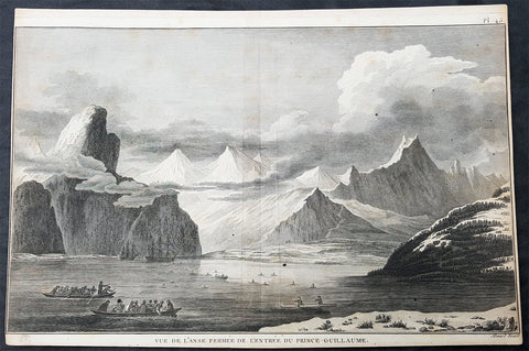
1785 Cook Antique Print HMS Resolution & Discovery, Prince William Sound, Alaska
- Title : Vue de Lanse Fermee de l entree Du Prince Guillaume (Entrance & view of the Prince William)
- Size: 14 1/2in x 10in (370mm x 255mm)
- Ref #: 31839
- Date : 1785
- Condition: (A) Very Good Condition
Description:
This fine original copper-plate engraved antique print of Captain Cooks ships HMS Resolution and Discovery anchored in Snug Corner Cove, Prince William Sound, Alaska, visited by Captain Cook in 1778, during his 3rd & last Voyage of Discovery, was engraved by Robert Benard - after John Webber - and was published in the 1785 French edition of Capt. James Cook & Capt. James King publication A Voyage to the Pacific Ocean. Undertaken, by the Command of his Majesty, for making Discoveries in the Northern Hemisphere. To determine The Position and Extent of the West Side of North America; its Distance from Asia; and the Practicability of a Northern Passage to Europe. Performed under the direction of Captains Cook, Clerke, and Gore, In His Majestys Ships the Resolution and Discovery. In the Years 1776, 1777, 1778, 1779, and 1780. In Three Volumes. Vol. I and II written by James Cook, F.R.S. Vol. III by Captain James King, LL.D. and F.R.S. Paris, 1785.
May 1778.........On the 12th at nine in the morning, wrote Ledyard, we entered an inlet… at six in the evening perceiving bad weather approaching… both ships anchored… The pinnace of the Resolution with the first lieutenant, some other gentlemen and myself went to the opposite shore to shoot some wild fowl. The first lieutenant was John Gore. The inlet was named Sandwich Sound by Cook, after the Earl of Sandwich, First Lord of the Admiralty, but in the published version of his journal the name appeared as Prince Williams Sound, after George IIIs third son, Duke of Clarence, later William IV. The ships had anchored off Cape Hinchinbrook, named after the country seat of the Earl of Sandwich.
Some local inhabitants appeared and came aboard the ships. Clerke gave them a Glass Bowl, with which they seem\'d much delighted, and toss\'d me, in spight of all my motions to the contrary, one of their Frocks, which was made of Water fowl Skins, and exceedingly well calculated, to keep out both Wet & Cold; then, both Boats put off and made for the Shore, paddling & singing with all the Jollity imaginable. We either found these good folks on of their Jubilee Days, or they are a very happy Race.
They sailed on until Cook found a fine bay or rather harbour which he later called a very snug place and named Snug Corner Bay. Samwell on 14th wrote we secured the Ship with the small Anchor; in carrying this out in the Launch one of the Sailors was so unfortunate as to get his Leg entangled in the Buoy rope which carried him down with the Anchor, however he disengaged himself when he got to the bottom & came up again & saved his Life tho\' he had his Leg broke in a very dangerous Manner.
We heeled the ship to port wrote Gilbert, to examine the leak on the starboard buttock… it being close below the wale and occasioned by some of the seems being very open and the oakum quite rotten and great part of it got out. In two days we repaired this defect being obliged to put two and half inch rope along the seams which were too wide for caulking.
On 18th King noted two boats, one with Mr Gore & the other with the Master, were sent away, the first to explore the Inlet to the Noward: the other to the N end of the Island near us to make observations on the tides. William Bligh was master on the Resolution. They returned by Dusk, Mr Gore had proceeded up the Inlet & perceivd that it took a direction to the NE, & he thought that it bid fair for opening a communication to some other Sea; but the mate that was with him form\'d a very contrary opinion… the Captn judg\'d it the Wisest way to lose no more time, being certain that if we were amongst Islands, we shoud soon come to more Passages. Henry Roberts was the masters mate referred to here. Cook had sent him and others to sketch out the parts they examined
General Definitions:
Paper thickness and quality: - Heavy and stable
Paper color : - off white
Age of map color: -
Colors used: -
General color appearance: -
Paper size: - 14 1/2in x 10in (370mm x 255mm)
Plate size: - 14in x 10in (365mm x 255mm)
Margins: - Min 1/2in (12mm)
Imperfections:
Margins: - L&R margins cropped close to borders
Plate area: - None
Verso: - Light soiling
Background:
Prince William Sound is located on the south coast of the U.S. state of Alaska. It is located on the east side of the Kenai Peninsula, its largest port is Valdez, at the southern terminus of the Trans-Alaska Pipeline System. Other settlements on the sound contain numerous small islands, including Cordova and Whittier plus the Alaska native villages of Chenega and Tatitlek.
James Cook entered Prince William Sound in 1778 and named it Sandwich Sound, after his patron the Earl of Sandwich. The name was changed to honour King George III third son, Prince William Henry, then aged 13 and serving as a midshipman in the Royal Navy.
Captain James King FRS 1750 – 1784 was an officer of the Royal Navy. He served under James Cook on his last voyage around the world, specialising in taking important astronomical readings using a sextant. After Cook died he helped lead the ships on the remainder of their course, also completing Cooks account of the voyage. He continued his career in the Navy, reaching the rank of post-captain, commanding several ships and serving in the American War of Independence.
King joined HMS Resolution as second lieutenant, sharing the duties of astronomer with Cook, taking astronomical observations on board by sextant and with Larcum Kendals timekeeper K1, to establish the Resolutions position at sea and on shore by sextant or by astronomical quadrant to establish the geographical position of salient points during the course of Cooks surveys. Thus Kings geographical positions were an important contribution to the accuracy of the various surveys carried out during the voyage and his use of the early chronometers helped prove their use at sea for calculation of Longitude. .
Following the death of Cook, King remained in the Resolution but on the death of Charles Clerke, Cooks successor, King was appointed to command HMS Discovery, the Resolutions consort, remaining in her for the rest of the voyage. After his return to England King was very much involved in the publication of the official account of Cooks third voyage, writing the third volume at Woodstock, near Oxford, where his brother Thomas was rector of St Mary Magdalene. But shortly after his return King was promoted Post-captain and appointed commander of HMS Crocodile in the English Channel.
John Webber RA 1751 – 1793 was an English artist who accompanied Captain Cook on his third Pacific expedition. He is best known for his images of Australasia, Hawaii and Alaska.
Webber was born in London, educated in Bern and studied painting at Paris.His father was Abraham Wäber, a Swiss sculptor who had moved to London, and changed his name to Webber before marrying a Mrs Mary Quant in 1744.
Webber served as official artist on James Cooks third voyage of discovery around the Pacific (1776–80) aboard HMS Resolution. At Adventure Bay in January 1777 he did drawings of A Man of Van Diemens Land and A Woman of Van Diemens Land. He also did many drawings of scenes in New Zealand and the South Sea islands. On this voyage, during which Cook lost his life in a fight in Hawaii, Webber became the first European artist to make contact with Hawaii, then called the Sandwich Islands. He made numerous watercolor landscapes of the islands of Kauai and Hawaii, and also portrayed many of the Hawaiian people.
In April 1778, Captain Cooks ships Resolution and Discovery anchored at Ship Cove, now known as Nootka Sound, Vancouver Island, Canada to refit. The crew took observations and recorded encounters with the local people. Webber made watercolour landscapes including Resolution and Discovery in Ship Cove, 1778. His drawings and paintings were engraved for British Admiraltys account of the expedition, which was published in 1784.
Back in England in 1780 Webber exhibited around 50 works at Royal Academy exhibitions between 1784 and 1792, and was elected an associate of the Royal Academy in 1785 and R.A. in 1791. Most of his work were landscapes. Sometimes figures were included as in A Party from H.M.S. Resolution shooting sea horses, which was shown at the academy in 1784, and his The Death of Captain Cook became well known through an engraving of it. Another version of this picture is in the William Dixson gallery at Sydney
Robert Bénard 1734 – 1777 was an 18th-century French engraver.
Specialized in the technique of engraving, Robert Ménard is mainly famous for having supplied a significant amount of plates (at least 1,800) to the Encyclopédie by Diderot & d Alembert from 1751.
Later, publisher Charles-Joseph Panckoucke reused many of his productions to illustrate the works of his catalog.
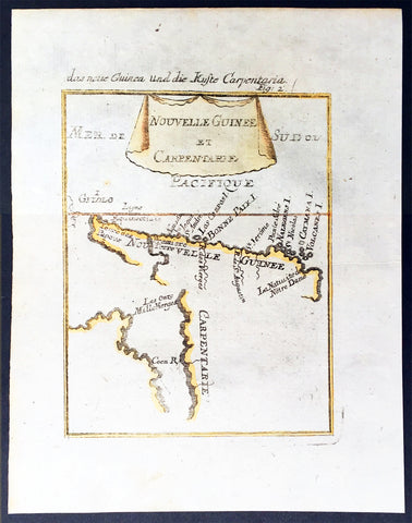
1683 Mallet Antique Map of Australia Cape York Peninsula Gulf of Carpenteria PNG
- Title : Nouvelle Guinee et Carpentarie
- Ref #: 50601
- Size: 8in x 6in (205mm x 152mm)
- Date : 1682
- Condition: (A+) Fine Condition
Description:
This hand coloured original antique very early map of Cape York Peninsula, the Gulf of Carpenteria and New Guinea - depicted before the Torres Strait was charted - was published as part of the 1683 edition of Alain Manesson Mallet's 1630 - 1706 Description de l' Univers.
Background:
The first detailed published map to show any part of Queensland (Tully). Shows New Guinea , the east coast of Cape York Peninsula and part of Arnhem Land.
Although not a particularly large map, the significance of Mallet's map of Carpentaria and New Guinea is underrated. It is essentially the first map to concentrate specifically on the Dutch discoveries in Queensland by Jan Cartenszoon in the Pera and the Arnhem that left Ambon on 21 January 1623 and reached the western side of Cape York Peninsula on 12 April. Although De Jode's rare and famous map 'Novae Guineae Forma & Situs', published almost a century earlier also charts the same area, it shows a fictitious Queensland based on the contemporary beliefs of a 'Terra Australis Incongita', or unknown southland.
Mallet names 'Coen R', one of the rivers discovered and named by Carstensz in 1623. No other Australian place names are shown except 'Carpentarie' on the Cape York Peninsula . Mallet places an interesting reference at the entrance of the Gulf of Carpentaria, "Les onze mille vierges", referring to the eleven thousand virgins of Cologne . A text carved into stone at the Church of Saint Ursula refers to the martyrdom of virgins.
Mallet was a French Engineer who in his early days took service with the Portuguese Army. He later returned to France and served Louis XIV. In 1683 he published Description de l' Univers which contained many hundreds of maps, plans and views. A German edition was published in 1686.
This is a beautifully engraved and hand coloured print in excellent condition. (Ref: Tooley; M&B)
Condition Report
Paper thickness and quality: - Heavy and stable
Paper color: - white
Age of map color: - Early
Colors used: - Yellow, green, blue, red
General color appearance: - Authentic
Paper size: - 8in x 6in (205mm x 152mm)
Plate size: - 6 1/2in x 5in (165mm x 127 mm)
Margins: - min. 1/2in (12mm)
Imperfections:
Margins: - None
Plate area: None
Verso: - None
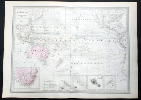
1857 A H Dufour Very Large Antique Map of Australia, New Zealand & South Pacific
- Title : Oceanie Dressee par A H Dufour Gravee CH Dyonnet..1857
- Ref #: 61026
- Size: 33in x 24in (840mm x 610mm)
- Date : 1857
- Condition: (A+) Fine Condition
Description:
This very large, magnificent hand coloured original copper plate antique map of Australia, New Zealand, Oceania & The Pacific, showing the Ocean Currents and 5 inset maps (NSW & Victoria Australia, Gambier Islands, Tahiti, Marquesas Isles & New Caledonia) by Adolphe Hippolyte Dufour was engraved by Charles Dyonnet in 1856 - dated in the title - for Dufours 1860 edition of his monumental elephant folio Atlas Physique, Historique et Politique Geographie Moderne published by Pauline Et La Chevalier, Paris.
The 19th century French cartographer Auguste-Henri Dufour began publishing the dramatic elephant folio Atlas Universel, also occasionally titled Grand Atlas Universal, around 1855. Several editions appeared between its initial publication in the 1850s and a final run c. 1870. The 1863 and 1864 editions in particular are highly desirable among collectors because the United States and North America maps illustrate the proposed, but unrealized, state of Corona (roughly modern day Utah). The atlas contained roughly 40 maps, most of which were engraved by Louis Antoine (the maps) and Deletre (typography) under the supervision of Charles Dyonnet, official engraver of the Depot de la Marine. The Atlas Universal was published in Paris and edited by the firm of Paulin et le Chevalier, 60 Rue Richelieu.
General Definitions:
Paper thickness and quality: - Heavy and stable
Paper color : - off white
Age of map color: - Original
Colors used: - Yellow, green, blue, pink
General color appearance: - Authentic
Paper size: - 33in x 24in (840mm x 610mm)
Plate size: - 33in x 24in (840mm x 610mm)
Margins: - Min 1in (25mm)
Imperfections:
Margins: - Light age toning in margins
Plate area: - None
Verso: - None
Background:
Charles Dyonnet 1822 - 1880 was an extremely active Paris based engraver working in the mid to late 19th century. From his offices at 220 Rue St. Jacques, Paris, Dyonnet engraved numerous maps for many of the most prominent 19th French cartographic publishers including Vuillemin, Dufour, Fremin and Duvotenay. From 1850-1861, he held the coveted position of Graveur du Dépot de la Marine, and in this position engraved numerous French naval and military maps. Dyonnet had a detail oriented and aesthetically minded hand and is responsible from some of the most beautiful French maps to emerge during the 19th century. (Ref: M&B; Tooley)
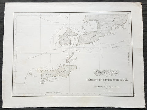
1803 Louis Freycinet Antique Map of The Islands of Timor, Samau & Rote Indonesia
- Title : Carte Particuliere des Detroits De Rottie et de Simao...L Freycienet...le Casuarina 1803..Lambert Sculp.
- Ref #: 42014
- Size: 22 1/2in x 16 1/2in (570mm x 420mm)
- Date : 1803
- Condition: (A+) Fine Condition
Description:
This magnificent large original copper-plate engraved antique map of the islands of Samau, Rote and the southern part of Timor, including the bay and town of Kupang, by Lieutenant Louis Freycinet, in command of the ship Casuarina in 1803, was engraved by Anton Lambart and was published in the 1807 1st edition of François Pérons, Voyage de découvertes aux terres australes (‘Voyage of Discovery to the Southern Lands in three volumes, Paris, 1807–1816.
Also illustrates the tracks of the ships Geographe, the Naturaliste from the earlier voyages in 1801, and the Casuarina tracks of 1803.
General Definitions:
Paper thickness and quality: - Heavy and stable
Paper color : - off white
Age of map color: - Original
Colors used: - Yellow, green, blue, pink
General color appearance: - Authentic
Paper size: - 22 1/2in x 16 1/2in (570mm x 420mm)
Plate size: - 21 1/2in x 15in (545mm x 380mm)
Margins: - Min 1in (25mm)
Imperfections:
Margins: - None
Plate area: - None
Verso: - None
Background:
Nicolas Thomas Baudin 1754 – 1803 was a French explorer, cartographer, naturalist and hydrographer.
The Baudin expedition of 1800 to 1803 was a French expedition to map the coast of New Holland (Australia). The expedition started with two ships, Géographe, captained by Baudin, and Naturaliste captained by Jacques Hamelin, and was accompanied by nine zoologists and botanists, including Jean-Baptiste Leschenault de la Tour, François Péron and Charles-Alexandre Lesueur as well as the geographer Pierre Faure.
Napoléon Bonaparte, as First Consul, formally approved the expedition to the coasts of New Holland, after receiving a delegation consisting of Baudin and eminent members of the Institut National des Sciences et Arts on 25 March 1800. The explicit purpose of the voyage was to be ‘bservation and research relating to Geography and Natural History.
The Baudin expedition departed Le Havre, France, on 19 October 1800. Because of delays in receiving his instructions and problems encountered in Isle de France (now Mauritius) they did not reach Cape Leeuwin on the south-west corner of the continent until May 1801. Upon rounding Cape Naturaliste, they entered Geographe Bay. During their exploration here they lost a longboat and a sailor, Assistant Helmsman Timothée Vasse. They then sailed north, but the ships became separated and did not meet again until they reached Timor. On their journeys the Géographe and the Naturaliste surveyed large stretches of the north-western coast. The expedition was severely affected by dysentery and fever, but sailed from Timor on 13 November 1801, back down the north-west and west coast, then across the Great Australian Bight, reaching Tasmania on 13 January 1802. They charted the whole length of Tasmanias east coast and there were extensive interactions with the Indigenous Tasmanians, with whom they had peaceful relationships. They notably produced precious ethnological studies of Indigenous Tasmanians.
The expedition then began surveying the south coast of Australia, but then Captain Jacques Felix Emmanuel Hamelin in Naturaliste decided to make for Port Jackson (Sydney) as he was running short of food and water, and in need of anchors. En route, in April 1802, Hamelin explored the area of Western Port, Victoria, and gave names to places, a number of which have survived, for example, Ile des Français is now called French Island.
Meanwhile, Baudin in the Géographe continued westward, and in April 1802 encountered the British ship Investigator commanded by Matthew Flinders, also engaged in charting the coastline, at Encounter Bay in what is now South Australia. Flinders informed Baudin of his discovery of Kangaroo Island, St. Vincents and Spencers Gulfs. Baudin sailed on to the Nuyts Archipelago, the point reached by \'t Gulden Zeepaert in 1627 before heading for Port Jackson as well for supplies.
In late 1802 the expedition was at Port Jackson, where the government sold 60 casks of flour and 25 casks of salt meat to Baudin to resupply his two vessels. The supplies permitted the Naturaliste to return to France and Géographe to continue her explorations of the Australian coast. Naturaliste took with her the Colonys staff surgeon, Mr. James Thomson, whom Governor Philip Gidley King had given permission to return to England.
Before resuming the voyage Baudin purchased a 30 ton schooner, which he named the Casuarina, a smaller vessel which could conduct close inshore survey work. He sent the larger Naturaliste under Hamelin back to France with all the specimens that had been collected by Baudin and his crew. As the voyage had progressed Louis de Freycinet, now a Lieutenant, had shown his talents as an officer and a hydrographer and so was given command of the Casuarina. The expedition then headed for Tasmania and conducted further charting of Bass Strait before sailing west, following the west coast northward, and after another visit to Timor, undertook further exploration along the north coast of Australia. Plagued by contrary winds, ill health, and because the quadrupeds and emus were very sick, it was decided on 7 July 1803 to return to France. On the return voyage, the ships stopped in Mauritius, where Baudin died of tuberculosis on 16 September 1803. The expedition finally reached France on 24 March 1804.
The scientific expedition was considered a great success, with more than 2500 new species discovered.
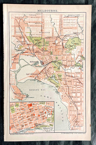
1896 F.A. Brockhaus Antique Map, Street Plan of Melbourne, Victoria, Australia
- Title : Melbourne
- Ref #: 27012
-
Condition: (A+) Fine Condition
- Size: 10in x 6 1/2in (255mm x 165mm)
- Date : 1896
Description:
This original antique lithograph street map of Melbourne Australia was engraved and published F.A. Brockhaus for the Brockhaus Konversations Lexikon, Germany, 1896
General Definitions:
Paper thickness and quality: - Heavy and stable
Paper color : - off white
Age of map color: - Original
Colors used: - Yellow, green, blue, pink
General color appearance: - Authentic
Paper size: - 10in x 6 1/2in (255mm x 165mm)
Plate size: - 10in x 6 1/2in (255mm x 165mm)
Margins: - Min 1/2in (12mm)
Imperfections:
Margins: - None
Plate area: - None
Verso: - None
Brockhaus, Friedrich Arnold (1772 - 1823)
Friedrich Arnold Brockhaus was a German encyclopedia publisher and editor, famed for publishing the Conversations-Lexikon, which is now published as the Brockhaus encyclopedia.
Brockhaus was educated at the gymnasium of his native Dortmund, and from 1788 to 1793 served an apprenticeship in a mercantile house at Düsseldorf. He then devoted two years at the University of Leipzig to the study of modern languages and literature, after which he set up in Dortmund an emporium for English goods. In 1801, he transferred this business to Arnheim, and in the following year to Amsterdam.
In 1805, having given up his first line of trade, Brockhaus began business as a publisher. Two journals projected by him were not allowed by the government to survive for any length of time, and in 1810 the complications in the affairs of Holland induced him to return homewards. In 1811 he settled at Altenburg. About three years previously he had purchased the copyright of the bankrupt Conversations-Lexikon, an encyclopedia started in 1796, and in 1810-1811 he completed the first edition of this celebrated work. It was widely imitated as a model for encyclopedias, and is still published today, known as the Brockhaus Encyclopedia.
A second edition under Brockhauss editorship was begun in 1812, and was received with universal favour. His business extended rapidly, and in 1818 Brockhaus moved to Leipzig, where he established a large printing-house. Among the more extensive of his many literary undertakings were the critical periodicals — Hermes, the Literarisches Konversationsblatt (afterwards the Blätter für literarische Unterhaltung) and the Zeilgenossen, and some large historical and bibliographical works, such as Friedrich Ludwig Georg von Raumers Geschichte der Hohenstaufen, and Friedrich Adolf Eberts Allgemeines bibliographisches Lexikon.
Brockhaus died in Leipzig. The business was carried on by his sons, Friedrich Brockhaus (1800–1865), who retired in 1850, and Heinrich Brockhaus (1804–1874), under whom it was considerably extended. Heinrich especially rendered great services to literature and science, which the University of Jena recognized by making him, in 1858, honorary Doctor of Philosophy. In the years 1842–1848, Heinrich Brockhaus was member of the Saxon second chamber, as representative for Leipzig, was made honorary citizen of that city in 1872, and died there on 15 November 1874.
His firm continues under the name F.A. Brockhaus AG in his honor. He is also the namesake of 27765 Brockhaus, a main-belt asteroid discovered in 1991.
Please note all items auctioned are genuine, we do not sell reproductions. A Certificate of Authenticity (COA) can be issued on request.
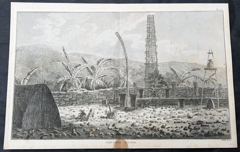
1785 Capt Cook Antique Print Interior of a Heiau, Island of Kauai Hawaii in 1778
- Title : Cimetiere D Atooi (Cemetery in Atooi)
- Size: 15 1/2in x 10in (390mm x 255mm)
- Ref #: 21441
- Date : 1785
- Condition: (A+) Fine Condition
Description:
This fine original copper-plate engraved antique print of the inside of a Hawaiian Heiau - temple - on the Island of Kauai (Atooi) Hawaii, visited by Captain Cook in 1778, during his 3rd & last Voyage of Discovery, was engraved by Robert Benard - after John Webber - and was published in the 1785 French edition of Capt. James Cook & Capt. James King publication A Voyage to the Pacific Ocean. Undertaken, by the Command of his Majesty, for making Discoveries in the Northern Hemisphere. To determine The Position and Extent of the West Side of North America; its Distance from Asia; and the Practicability of a Northern Passage to Europe. Performed under the direction of Captains Cook, Clerke, and Gore, In His Majestys Ships the Resolution and Discovery. In the Years 1776, 1777, 1778, 1779, and 1780. In Three Volumes. Vol. I and II written by James Cook, F.R.S. Vol. III by Captain James King, LL.D. and F.R.S. Paris, 1785.
Captain Cook arrived at Atooi (Kauai) on 19th January 1778 and stayed until 23rd January 1778.
On the 21st January, Cook accompanied by John Webber, proceeded inland from their beach side anchorage to Waimea, on the south coast of Kauai. Their intention was to examine elevated objects visible from the ship. It proved to be a morai, or temple similar to ones they had seen in Tahiti and other South Pacific islands. This structure was nearly 20-feet high and covered in a thin, light-grey cloth, which likely had ceremonial significance. The temple rested on a platform and consisted of thousands of rough-edged lava rock piled in a tight, mortarless fashion. In the center is the spindly-legged oracle tower, where the priest (kahuna) might seek counsel or pray. Carved figures with tapa and leaf offerings are seen outside thatched huts topped with pili, the tall grass that grew throughout the lowlands. In his journal, Cook took particular note of several stone objects he had observed:
...........about the middle of the Morai, there were three of these places in line. We were told three chiefs had been buried there, and before them was another that was oblong. This they called Tanga (taboo or kapu in Hawaiian) and gave us clearly to understand that three human sacrifices had been buried there, that is, one at the burial of each chief. Cooks Journals - January 21, 1778
General Definitions:
Paper thickness and quality: - Heavy and stable
Paper color : - off white
Age of map color: -
Colors used: -
General color appearance: -
Paper size: - 15 1/2in x 10in (390mm x 255mm)
Plate size: - 14 1/2in x 9 1/2in (370mm x 245mm)
Margins: - Min 1/2in (12mm)
Imperfections:
Margins: - Light soiling
Plate area: - None
Verso: - Light soiling
Background:
Kauai is geologically the oldest of the main Hawaiian Islands.
In 1778, Captain James Cook arrived at Waimea Bay, the first European known to have reached the Hawaiian islands. He named the archipelago after his patron the 6th Earl of Sandwich, George Montagu
Hawaii is the 50th and most recent state to have joined the United States of America, having received statehood on August 21, 1959. Hawaii is the only U.S. state located in Oceania and the only one composed entirely of islands. It is the northernmost island group in Polynesia, occupying most of an archipelago in the central Pacific Ocean. Hawaii is the only U.S. state located outside North America.
It is possible that Spanish explorers arrived in the Hawaiian Islands in the 16th century—200 years before Captain James Cook\\\'s first documented visit in 1778. Ruy López de Villalobos commanded a fleet of six ships that left Acapulco in 1542 bound for the Philippines with a Spanish sailor named Juan Gaetano aboard as pilot. Depending on the interpretation, Gaetanos reports describe an encounter with either Hawaii or the Marshall Islands. If de Villalobos crew spotted Hawaii, Gaetano would be considered the first European to see the islands. Some scholars have dismissed these claims due to a lack of credibility.
Spanish archives contain a chart that depicts islands at the same latitude as Hawaii but with a longitude ten degrees east of the islands. In this manuscript, the island of Maui is named La Desgraciada (The Unfortunate Island), and what appears to be Hawaii Island is named La Mesa (The Table). Islands resembling Kahoolawe, Lanai, and Molokai are named Los Monjes (The Monks). For two-and-a-half centuries, Spanish galleons crossed the Pacific from Mexico along a route that passed south of Hawaii on their way to Manila. The exact route was kept secret to protect the Spanish trade monopoly against competing powers.
The 1778 arrival of British explorer James Cook was the first documented contact by a European explorer with Hawaii. Cook named the archipelago as the Sandwich Islands in honor of his sponsor John Montagu, 4th Earl of Sandwich. Cook published the islands location and rendered the native name as Owyhee. This spelling lives on in Owyhee County, Idaho. It was named after three native Hawaiian members of a trapping party who went missing in that area. The Owyhee Mountains were also named for them
Cook visited the Hawaiian Islands twice. As he prepared for departure after his second visit in 1779, a quarrel ensued as Cook took temple idols and fencing as firewood and a minor chief and his men took a ship\\\'s boat. Cook abducted the King of Hawaii Island, Kalani ōpu u, and held him for ransom aboard his ship in order to gain return of Cook\\\'s boat. This tactic had worked in Tahiti and other islands. Instead, Kalani ōpu u s supporters fought back, killing Cook and four marines as Cooks party retreated along the beach to their ship. They departed without the ships boat.
Captain James King FRS 1750 – 1784 was an officer of the Royal Navy. He served under James Cook on his last voyage around the world, specialising in taking important astronomical readings using a sextant. After Cook died he helped lead the ships on the remainder of their course, also completing Cooks account of the voyage. He continued his career in the Navy, reaching the rank of post-captain, commanding several ships and serving in the American War of Independence.
King joined HMS Resolution as second lieutenant, sharing the duties of astronomer with Cook, taking astronomical observations on board by sextant and with Larcum Kendals timekeeper K1, to establish the Resolutions position at sea and on shore by sextant or by astronomical quadrant to establish the geographical position of salient points during the course of Cooks surveys. Thus Kings geographical positions were an important contribution to the accuracy of the various surveys carried out during the voyage and his use of the early chronometers helped prove their use at sea for calculation of Longitude. .
Following the death of Cook, King remained in the Resolution but on the death of Charles Clerke, Cooks successor, King was appointed to command HMS Discovery, the Resolutions consort, remaining in her for the rest of the voyage. After his return to England King was very much involved in the publication of the official account of Cooks third voyage, writing the third volume at Woodstock, near Oxford, where his brother Thomas was rector of St Mary Magdalene. But shortly after his return King was promoted Post-captain and appointed commander of HMS Crocodile in the English Channel.
John Webber RA 1751 – 1793 was an English artist who accompanied Captain Cook on his third Pacific expedition. He is best known for his images of Australasia, Hawaii and Alaska.
Webber was born in London, educated in Bern and studied painting at Paris.His father was Abraham Wäber, a Swiss sculptor who had moved to London, and changed his name to Webber before marrying a Mrs Mary Quant in 1744.
Webber served as official artist on James Cooks third voyage of discovery around the Pacific (1776–80) aboard HMS Resolution. At Adventure Bay in January 1777 he did drawings of A Man of Van Diemens Land and A Woman of Van Diemens Land. He also did many drawings of scenes in New Zealand and the South Sea islands. On this voyage, during which Cook lost his life in a fight in Hawaii, Webber became the first European artist to make contact with Hawaii, then called the Sandwich Islands. He made numerous watercolor landscapes of the islands of Kauai and Hawaii, and also portrayed many of the Hawaiian people.
In April 1778, Captain Cooks ships Resolution and Discovery anchored at Ship Cove, now known as Nootka Sound, Vancouver Island, Canada to refit. The crew took observations and recorded encounters with the local people. Webber made watercolour landscapes including Resolution and Discovery in Ship Cove, 1778. His drawings and paintings were engraved for British Admiraltys account of the expedition, which was published in 1784.
Back in England in 1780 Webber exhibited around 50 works at Royal Academy exhibitions between 1784 and 1792, and was elected an associate of the Royal Academy in 1785 and R.A. in 1791. Most of his work were landscapes. Sometimes figures were included as in A Party from H.M.S. Resolution shooting sea horses, which was shown at the academy in 1784, and his The Death of Captain Cook became well known through an engraving of it. Another version of this picture is in the William Dixson gallery at Sydney
Robert Bénard 1734 – 1777 was an 18th-century French engraver.
Specialized in the technique of engraving, Robert Ménard is mainly famous for having supplied a significant amount of plates (at least 1,800) to the Encyclopédie by Diderot & d Alembert from 1751.
Later, publisher Charles-Joseph Panckoucke reused many of his productions to illustrate the works of his catalog.
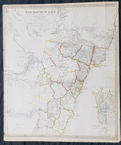
1833 SDUK Antique Map of New South Wales, Australia with inset plan of Sydney
- Title : New South Wales..1833 Baldwin & Craddock
- Size: 16in x 13 1/2in (405mm x 350mm)
- Condition: (A+) Fine Condition
- Date : 1833
- Ref #: 21290
Description:
This fine hand coloured original steel plate engraved antique maps of New South Wales - with an inset plan of Sydney Town - was engraved by J & C Walker, in 1833- date engraved at the foot of the map - and was published in the Baldwin & Craddock edition of the Society For the Diffusion of Useful Knowledge (SDUK) Atlas.
General Definitions:
Paper thickness and quality: - Heavy and stable
Paper color : - off white
Age of map color: - Original
Colors used: - Yellow, Green, pink
General color appearance: - Authentic
Paper size: - 16in x 13 1/2in (405mm x 350mm)
Plate size: - 16in x 13 1/2in (405mm x 350mm)
Margins: - Min 1/2in (12mm)
Imperfections:
Margins: - Left margin cropped to border
Plate area: - None
Verso: - None
Background:
The SDUK produced two landmark volumes of cartography in the first half of the 19th century. The first volume concentrated on areas of the old world, Europe, Africa, Great Britain etc. The second volume contained maps of the new world, Alvin Jewett JohnsonAmerica, South Asia, including US state maps, colonies of Australia, South Africa, South America etc. Also included were some of the finest engraved town and city plans published at that time.
The SDUK was published in its entirety or in part by many publishers including Baldwin and Cradock 1829-32, Chapman & Hall in 1844, Charles Knight & co. 1846 – 1852. G. Cox published the SDUK between 1852-3, Stanford 1857-70 and later revised edition were also published after Stanford. (Ref: Tooley, M&B)
1780 Rigobert Bonne Antique Map of New Guinea, William Dampier 1699 - 5 Harbours
- Title : Carte des Decouvertes du Capt,. Carteret dans La Nlle. Bretagne..Par M Bonne
- Date : 1780
- Size: 16in x 11in (405mm x 2805mm)
- Ref #: 40581
- Condition: (A+) Fine Condition
Description:
This fine original copper plate engraved antique map of Papua New Guinea - and the early discoveries of William Dampier and the later passage of Cooks ship the Endeavor through the straits between Australia and New Guinea, by Rigobert Bonne was published in the 1780 edition of Atlas des toutes les parties connues du globe terrestre by Guillaume Raynal.
The map also contains the bays, Harbours and coastlines of several Islands of the Pacific including New Ireland, Philippines, Indonesia.(Ref Tooley M&B)
General Definitions:
Paper thickness and quality: - Heavy and stable
Paper color : - off white
Age of map color: - Early
Colors used: - Yellow, Green, pink
General color appearance: - Authentic
Paper size: - 16 ½in x 11 ½in; (420mm x 295mm)
Plate size: - 14 ½in x 10in; (370mm x 250mm)
Margins: - Min 1/2in (12mm)
Imperfections:
Margins: - None
Plate area: - Light offsetting
Verso: - None
Background:
William Dampier 1651 - 1715 was an English explorer and navigator who became the first Englishman to explore parts of what is today Australia, and the first person to circumnavigate the world three times. He has also been described as Australia\'s first natural historian, as well as one of the most important British explorers of the period between Sir Walter Raleigh and James Cook.
After impressing the Admiralty with his book A New Voyage Round the World, Dampier was given command of a Royal Navy ship and made important discoveries in Western Australia, before being court-martialled for cruelty. On a later voyage he rescued Alexander Selkirk, a former crewmate who may have inspired Daniel Defoes Robinson Crusoe. Others influenced by Dampier include James Cook, Horatio Nelson, Charles Darwin, and Alfred Russel Wallace.
1780 Rigobert Bonne Antique Map of New Guinea, William Dampier 1699 - 5 Harbours
- Title : Carte des Decouvertes du Capt,. Carteret dans La Nlle. Bretagne..Par M Bonne
- Date : 1780
- Size: 17in x 12 1/2in (430mm x 310mm)
- Ref #: 16105
- Condition: (A+) Fine Condition
Description:
This fine original copper plate engraved antique map of Papua New Guinea - and the early discoveries of William Dampier and the later passage of Cooks ship the Endeavor through the straits between Australia and New Guinea, by Rigobert Bonne was published in the 1780 edition of Atlas des toutes les parties connues du globe terrestre by Guillaume Raynal.
The map also contains the bays, Harbours and coastlines of several Islands of the Pacific including New Ireland, Philippines, Indonesia.(Ref Tooley M&B)
General Definitions:
Paper thickness and quality: - Heavy and stable
Paper color : - off white
Age of map color: -
Colors used: -
General color appearance: -
Paper size: - 17in x 12 1/2in (430mm x 310mm)
Plate size: - 14 ½in x 10in; (370mm x 250mm)
Margins: - Min 1/2in (12mm)
Imperfections:
Margins: - None
Plate area: - None
Verso: - None
Background:
William Dampier 1651 - 1715 was an English explorer and navigator who became the first Englishman to explore parts of what is today Australia, and the first person to circumnavigate the world three times. He has also been described as Australia\'s first natural historian, as well as one of the most important British explorers of the period between Sir Walter Raleigh and James Cook.
After impressing the Admiralty with his book A New Voyage Round the World, Dampier was given command of a Royal Navy ship and made important discoveries in Western Australia, before being court-martialled for cruelty. On a later voyage he rescued Alexander Selkirk, a former crewmate who may have inspired Daniel Defoes Robinson Crusoe. Others influenced by Dampier include James Cook, Horatio Nelson, Charles Darwin, and Alfred Russel Wallace.
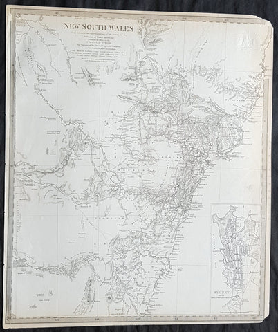
1833 SDUK Antique Map of New South Wales w/ inset Map of Sydney Town, Australia
- Title : New South Wales...Sydney from the New South Wales Almanack...Sep 1833
- Size: 16in x 14in (410mm x 355m)
- Condition: (A) Very Good Condition
- Date : 1833
- Ref #: 32681
Description:
This fine original antique map of New South Wales, Australia - with an inset plan of Sydney Town - was engraved by J & C Walker, in 1833 - the date is engraved at the foot of the map - and was published in the Baldwin & Craddock edition of the Society For the Diffusion of Useful Knowledge (SDUK) Atlas.
General Definitions:
Paper thickness and quality: - Heavy and stable
Paper color : - off white
Age of map color: -
Colors used: -
General color appearance: -
Paper size: - 16in x 14in (410mm x 355m)
Plate size: - 16in x 14in (410mm x 355m)
Margins: - Min 1/4in (5mm)
Imperfections:
Margins: - Light age toning, left T&B corners cropped
Plate area: - Blind Library stamp
Verso: - Re-enforced on verso along margins
Background:
The SDUK produced two landmark volumes of cartography in the first half of the 19th century. The first volume concentrated on areas of the old world, Europe, Africa, Great Britain etc. The second volume contained maps of the new world, America, South Asia, including US state maps, colonies of Australia, South Africa, South America etc. Also included were some of the finest engraved town and city plans published at that time.
The SDUK was published in its entirety or in part by many publishers including Baldwin and Cradock 1829-32, Chapman & Hall in 1844, Charles Knight & co. 1846 – 1852. G. Cox published the SDUK between 1852-3, Stanford 1857-70 and later revised edition were also published after Stanford. (Ref: Tooley, M&B)
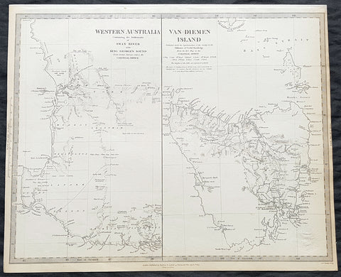
1833 SDUK Antique Map of Western Australia, Swan River Colony & Van Diemens Land
- Title : Western Australia containing the settlment of Swan River and King Georges Sound; Van-Diemens Land
- Size: 16in x 14in (410mm x 355m)
- Condition: (A) Very Good Condition
- Date : 1833
- Ref #: 32682
Description:
This original antique map of Western Australia - only 4 years after the first British settlement on the Swan river & Van Diemens Land or Tasmania was engraved by J & C Walker, in 1833 - the date is engraved at the foot of the map - and was published in the Baldwin & Craddock edition of the Society For the Diffusion of Useful Knowledge (SDUK) Atlas.
General Definitions:
Paper thickness and quality: - Heavy and stable
Paper color : - off white
Age of map color: -
Colors used: -
General color appearance: -
Paper size: - 16in x 14in (410mm x 355m)
Plate size: - 16in x 14in (410mm x 355m)
Margins: - Min 1/4in (5mm)
Imperfections:
Margins: - Light age toning
Plate area: - Blind Library stamp
Verso: - Re-enforced on verso along margins
Background:
The SDUK produced two landmark volumes of cartography in the first half of the 19th century. The first volume concentrated on areas of the old world, Europe, Africa, Great Britain etc. The second volume contained maps of the new world, America, South Asia, including US state maps, colonies of Australia, South Africa, South America etc. Also included were some of the finest engraved town and city plans published at that time.
The SDUK was published in its entirety or in part by many publishers including Baldwin and Cradock 1829-32, Chapman & Hall in 1844, Charles Knight & co. 1846 – 1852. G. Cox published the SDUK between 1852-3, Stanford 1857-70 and later revised edition were also published after Stanford. (Ref: Tooley, M&B)
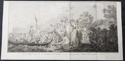
1778 Capt Cook Antique Print of Capt Cook Landing on Eua Island, Tonga in 1773
- Title : Debarquement A Middelburgh L une des Isles Friendly, (Des Amis) (Landing A Middelburgh one of the Friendly Isles, (friends)
- Size: 20in x 9 1/2in (510mm x 245mm)
- Ref #: 21497
- Date : 1778
- Condition: (A) Very Good Condition
Description:
This large original copper-plate engraved antique print of Captain Cook landing on the Island of Eua - with HMS Resolution in the background - (named Middelburg by the Dutch explorer Abel Tasman in 1643) a small island close the the main island of Tongatapu, in the Kingdom of Tonga, visited by Captain James Cook in 1773, during his 2nd Voyage of Discovery to the South Seas, was engraved by Robert Benard - after William Hodges - and was published in the 1778 French edition of Capt. James Cooks 2nd Voyage of Discovery to the South Seas A voyage towards the South Pole, and round the World. Performed in His Majestys ships the Resolution and Adventure, in the years 1772, 1773, 1774, and 1775..... Paris : Hotel de Thou ......1778.
As it was, Cook did not encounter the Tongan islands until his Second Voyage, when he stopped at both \'Eua and Tongatapu (or, by Tasman\'s nomenclature, Middleburg and Amsterdam respectively) in October of 1773. Here he was welcomed a shore by acclamations from an immence [sic] crowd of Men and Women not one of which had so much as a stick in their hands.
Indeed, Cook found the islanders to be so accommodating that he returned to the archipelago in 1774 on his way back from New Zealand. Stopping at the island of Nomuka, Cook was sought out by name, and with this proof that these people have a communication with Amsterdam, the cultural unity of the islands was established.
It was at this time that he famously named the island group the Friendly Archipelago, as a lasting friendship seems to subsist among the Inhabitants and their Courtesy to Strangers intitles [sic] them to that Name.
Cooks Third Voyage also included a visit to Tonga, this time for a stay of several months. Cook first dropped anchor at Nomuka in May, and then, at the invitation of the great chief Finau, travelled to another island, Lifuka. Here, Cook and his men were treated to such entertainments as whould [sic] have met with universal applause on a European Theatre.
General Definitions:
Paper thickness and quality: - Heavy and stable
Paper color : - off white
Age of map color: -
Colors used: -
General color appearance: -
Paper size: - 20in x 9 1/2in (510mm x 245mm)
Plate size: - 19in x 9 1/2in (480mm x 245mm)
Margins: - Min 1/2in (12mm)
Imperfections:
Margins: - Light soiling
Plate area: - Folds as issued, creasing along folds
Verso: - Light soiling
Background:
Eua is a smaller but still major island in the kingdom of Tonga. It is close to Tongatapu, but forms a separate administrative division
Eua was put on the European maps by Abel Tasman who reached it and Tongatapu on 21 January 1643. He called it Middelburg Island, after the capital of the Dutch province of Zeeland. He did not go on land, but proceeded to the Hihifo district of Tongatapu, which he named Amsterdam Island after the capital of the Netherlands.
Tonga officially the Kingdom of Tonga, is a Polynesian sovereign state and archipelago comprising 169 islands, of which 36 are inhabited. The total surface area is about 750 square kilometres (290 sq mi) scattered over 700,000 square kilometres (270,000 sq mi) of the southern Pacific Ocean. It has a population of 107,122 people, of whom 70% reside on the main island of Tongatapu.
The Tongan people first encountered Europeans in 1616 when the Dutch vessel Eendracht, captained by Willem Schouten, made a short visit to trade. Later came other Dutch explorers, including Jacob Le Maire (who called on the northern island of Niuatoputapu); and in 1643 Abel Tasman (who visited Tongatapu and Haapai).
Later noteworthy European visitors included James Cook (Royal Navy) in 1773, 1774, and 1777; Alessandro Malaspina (Spanish Navy) in 1793; the first London missionaries in 1797; and the Wesleyan Methodist Reverend Walter Lawry in 1822.
Tonga became known in the West as the Friendly Islands because of the congenial reception accorded to Captain James Cook on his first visit in 1773. He arrived at the time of the inasi festival, the yearly donation of the First Fruits to the Tui Tonga (the islands paramount chief) and so received an invitation to the festivities. According to the writer William Mariner, the chiefs wanted to kill Cook during the gathering but could not agree on a plan.
William Hodges RA 1744 – 1797 was an English painter. He was a member of James Cooks second voyage to the Pacific Ocean, and is best known for the sketches and paintings of locations he visited on that voyage, including Table Bay, Tahiti, Easter Island, and the Antarctic.
Between 1772 and 1775 Hodges accompanied James Cook to the Pacific as the expeditions artist. Many of his sketches and wash paintings were adapted as engravings in the original published edition of Cooks journals from the voyage.
Most of the large-scale landscape oil paintings from his Pacific travels for which Hodges is best known were finished after his return to London; he received a salary from the Admiralty for the purposes of completing them. These paintings depicted a stronger light and shadow than had been usual in European landscape tradition. Contemporary art critics complained that his use of light and colour contrasts gave his paintings a rough and unfinished appearance.
Hodges also produced many valuable portrait sketches of Pacific islanders and scenes from the voyage involving members of the expedition..
Robert Bénard 1734 – 1777 was an 18th-century French engraver.
Specialized in the technique of engraving, Robert Ménard is mainly famous for having supplied a significant amount of plates (at least 1,800) to the Encyclopédie by Diderot & d\'Alembert from 1751.
Later, publisher Charles-Joseph Panckoucke reused many of his productions to illustrate the works of his catalog.
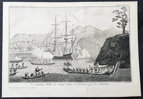
1774 Hawkesworth Antique Print Capt Wallis attacked in Matavia Bay, Tahiti, 1767
- Title : Le Capitaine Wallis est attaque dans L Dauphin par les Otahitiens (Captain Wallis attacked in The Dolphin by the Tahitians)
- Size: 14in x 10in (365mm x 255mm)
- Ref #: 25928
- Date : 1774
- Condition: (A+) Fine Condition
Description:
This fine original copper-plate engraved antique print of Captain Samuel Wallis in his ship the HMS Dolphin being attacked by the Tahitians in Matavai Bay - with one tree hill to the right - in 1767 was engraved by Robert Benard and was published in the 1774 French edition of John Hawkesworths An Account of the Voyages Undertaken by the Order of His Present Majesty for Making Discoveries in the Southern Hemisphere and Successively Performed by Commodore Byron, Captain Wallis, Captain Carteret, and Captain Cook, in the Dolphin, the Swallow, and the Endeavor, Drawn Up from the Journals Which Were Kept by the Several Commanders, and from the Papers of Joseph Banks, Esq. Paris 1774
From the log of Samuel Wallis, Captain of The Dolphin 1767.......
At two in the morning, it being very clear, we made sail again; at day-break we saw the land, at about five leagues distance, and steered directly for it; but at eight o’clock, when we were close under it, the fog obliged us again to lie to, and when it cleared away, we were much surprised to find ourselves surrounded by some hundreds of canoes…. When they came within pistol shot of the ship, they lay by, gazing at us with great astonishment, and by turns conferring with each other. In the mean time we showed them trinkets of various kinds, and invited them on board. Soon after, they drew together, and held a kind of council, to determine what should be done: then they all paddled around the ship, making signs of friendship, and one of them holding up a branch of the plantain tree, made a speech that lasted near a quarter of an hour, and then threw it into the sea. Soon after, as we continued to make signs of invitation, a fine, stout, lively young man ventured on board: he came up by the mizzen chains, and jumped out of the shrouds on top of the awning. We made signs to him to come down upon the quarter-deck, and handed up some trinkets to him: he looked pleased, but would accept of nothing till some of the Indians came alongside, and after much talk, threw a few branches of plantain tree on board the ship. He then accepted our presents, and several others very soon came on board.
As we had no anchorage here, we stood along the shore, sending the boats at the same time to sound at a less distance…. About three o’clock in the afternoon, we brought to, abreast of a large bay, where there was an appearance of anchorage. The boats were immediately sent to sound it, and while they were thus employed, I observed a great number of canoes gather round them. I suspected that the Indians had a design to attack them, and as I was very desirous to prevent mischief, I made the signal for the boats to come aboard, and at the same time, to intimidate the Indians, I fired a nine-pounder over their heads. As soon as the cutter began to stand towards the ship, the Indians in their canoes, though they had been startled by the thunder of our nine-pounder, endeavoured to cut her off. The boat, however, sailing faster than the canoes could paddle, soon got clear of those that were about her; but some others, that were full of men, waylaid her in her course, and threw several stones into her, which wounded some of the people. Upon this, the officer on board fired a musquet, loaded with buck-shot, at the man who threw the first stone, and wounded him in the shoulder. The rest of the people in the canoes, as soon as they perceived their companion wounded, leapt in to the sea, and the other canoes paddled away, in great terror and confusion.
General Definitions:
Paper thickness and quality: - Heavy and stable
Paper color : - off white
Age of map color: -
Colors used: -
General color appearance: -
Paper size: - 14in x 10in (365mm x 255mm)
Plate size: - 14in x 10in (365mm x 255mm)
Margins: - Min 1/2in (12mm)
Imperfections:
Margins: - None
Plate area: - Folds as issued
Verso: - None
Background:
Samuel Wallis 1728 – 1795
was a British naval officer and explorer of the Pacific Ocean.
Wallis was born near Camelford, Cornwall. He served under John Byron, and in 1766 was promoted to captain and was given the command of HMS Dolphin (1751) as part of an expedition led by Philip Carteret in the Swallow with an assignment to circumnavigate the globe. The two ships were parted by a storm shortly after sailing through the Strait of Magellan, Wallis continuing to Tahiti, which he named King George the Thirds Island in honour of the King (June 1767). Wallis himself was ill and remained in his cabin: lieutenant Tobias Furneaux was the first to set foot, hoisting a pennant and turning a turf, taking possession in the name of His Majesty. Dolphin stayed in Matavai Bay in Tahiti for over a month. Wallis went on to name or rename five more islands in the Society Islands and six atolls in the Tuamotu Islands, as well as confirming the locations of Rongerik and Rongelap in the Marshall Islands. He renamed the Polynesian island of Uvea as Wallis after himself, before reaching Tinian in the Mariana Islands. He continued to Batavia, where many of the crew died from dysentery, then via the Cape of Good Hope to England, arriving in May 1768. He was able to pass on useful information to James Cook who was due to depart shortly for the Pacific, and some of the crew from the Dolphin sailed with Cook. In 1780 Wallis was appointed Commissioner of the Admiralty.
Tahiti previously also known as Otaheite is the largest island in the Windward group of French Polynesia. The island is located in the archipelago of the Society Islands in the central Southern Pacific Ocean.
The first European to have visited Tahiti according to existing records was lieutenant Samuel Wallis, who was circumnavigating the globe in HMS Dolphin, sighting the island on 18 June 1767, and eventually harboring in Matavai Bay. This bay was situated on the territory of the chiefdom of Pare-Arue, governed by Tu (Tu-nui-e-a a-i-te-Atua) and his regent Tutaha, and the chiefdom of Ha apape, governed by Amo and his wife Oberea (Purea). Wallis named the island King Georges Island. The first contacts were difficult, since on the 24 and 26 June 1767, Tahitian warriors in canoes showed aggression towards the British, hurling stones from their slings. In retaliation, the British sailors opened fire on the warriors in the canoes and on the hills. In reaction to this powerful counter-attack, the Tahitians laid down peace offerings for the British. Following this episode, Samuel Wallis was able to establish cordial relations with the female chieftain “Oberea “ (Purea) and remained on the island until 27 July 1767.
In July 1768, Captain James Cook was commissioned by the Royal Society and on orders from the Lords Commissioners of the Admiralty to observe the transit of Venus across the sun, a phenomenon that would be visible from Tahiti on 3 June 1769. He arrived in Tahitis Matavai Bay, commanding the HMS Endeavour on 12 April 1769. On 14 April, Cook met with Tutaha and Tepau. On 15 April, Cook picked the site for a fortified camp at Point Venus along with Banks, Parkinson, Daniel Solander, to protect Charles Greens observatory. The length of stay enabled them to undertake for the first time real ethnographic and scientific observations of the island. Assisted by the botanist Joseph Banks, and by the artist Sydney Parkinson, Cook gathered valuable information on the fauna and flora, as well as the native society, language and customs, including the proper name of the island, Otaheite. On 28 April, Cook met Purea and Tupaia, and Tupaia befriended Banks following the transit. On 21 June, Amo visited Cook, and then on 25 June, Pohuetea visited, signifying another chief seeking to ally himself with the British.
Cook and Banks circumnavigated the island from 26 June to 1 July. On the exploration, they met Ahio, chief of Ha apaiano o or Papenoo, Rita, chief of Hitia a, Pahairro, chief of Pueu, Vehiatua, chief of Tautra, Matahiapo, chief of Teahupo o, Tutea, chief of Vaira o, and Moe, chief of Afa Ahiti. In Papara, guided by Tupaia, they investigated the ruins of Mahaiatea marae, an impressive structure containing a stone pyramid or ahu, measuring 44 feet high, 267 feet long and 87 feet wide. Cook and the Endeavour departed Tahiti on 13 July 1769, taking Raiatean navigator Tupaia along for his geographic knowledge of the islands.
Cook returned to Tahiti between 15 August and 1 September 1773, greeted by the chiefs Tai and Puhi, besides the youg ari i Vehiatua II and his stepfather Ti itorea. Cook anchored in Vaitepiha Bay before returning to Point Venus where he met Tu, the paramount chief. Cook picked up two passengers from Tahiti during this trip, Porea and Mai, with Hitihiti later replacing Porea when Cook stopped at Raiatea. Cook took Hitihiti to Tahiti on 22 April, during his return leg. Then, Cook departed Tahiti on 14 May 1774.
During his final visit, Cook returned Mai to Tahiti on 12 Aug. 1777, after Mais long visit in England. Cook also brought two Maori from Queen Charlotte Sound, Te Weherua and Koa. Cook first harbored in Vaitepiha Bay, where he visited Vehiatua II s funeral bier and the prefabricated Spanish mission house. Cook also met Vehiatua III, and inscribed on the back of the Spanish cross, Georgius tertius Rex Annis 1767, 69, 73, 74 & 77, as a counterpoint to Christus Vincit Carolus III imperat 1774 on the front. On 23 Aug., Cook sailed for Matavai Bay, where he met Tu, his father Teu, his mother Tetupaia, his brothers Ari ipaea and Vaetua, and his sisters Ari ipaea-vahine, Tetua-te-ahamai, and Auo. Cook also observed a human sacrifice, taata tapu, at the Utu-ai-mahurau marae, and 49 skulls from previous victims.
On 29 Sept. 1777, Cook sailed for Papetoai Bay on Moorea. Cook met Mahine in an act of friendship on 3 Oct., though he was an enemy of Tu. When a goat kid was stolen on 6 Oct., Cook in a rampage, ordered the burning of houses and canoes until it was returned. Cook sailed for Huahine on 11 Oct., Raiatea on 2 Nov., and Borabora on 7 Dec.
On 26 October 1788, HMS Bounty, under the command of Captain William Bligh, landed in Tahiti with the mission of carrying Tahitian breadfruit trees (Tahitian: uru) to the Caribbean. Sir Joseph Banks, the botanist from James Cooks first expedition, had concluded that this plant would be ideal to feed the African slaves working in the Caribbean plantations at very little cost. The crew remained in Tahiti for about five months, the time needed to transplant the seedlings of the trees. Three weeks after leaving Tahiti, on 28 April 1789, the crew mutinied on the initiative of Fletcher Christian. The mutineers seized the ship and set the captain and most of those members of the crew who remained loyal to him adrift in a ships boat. A group of mutineers then went back to settle in Tahiti.
Although various explorers had refused to get involved in tribal conflicts, the mutineers from the Bounty offered their services as mercenaries and furnished arms to the family which became the Pōmare Dynasty. The chief Tū knew how to use their presence in the harbours favoured by sailors to his advantage. As a result of his alliance with the mutineers, he succeeded in considerably increasing his supremacy over the island of Tahiti.
Robert Bénard 1734 – 1777 was an 18th-century French engraver.
Specialized in the technique of engraving, Robert Ménard is mainly famous for having supplied a significant amount of plates (at least 1,800) to the Encyclopédie by Diderot & d\'Alembert from 1751.
Later, publisher Charles-Joseph Panckoucke reused many of his productions to illustrate the works of his catalog.
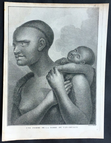
1785 Capt. Cook Antique Print Aboriginal Woman of Bruny Island, Tasmania in 1777
- Title : Une Femme De La Terre De Van-Diemens
- Ref : 50609
- Size: 10in x 8in (255mm x 205mm)
- Date : 1785
- Condition: (A+) Fine Condition
Description:
This fine original copper-plate engraved antique print of an Indigenous Woman & child of Adventure Bay, Bruny Island, Tasmania (Van Diemens Land) encountered by Captain Cook in during his 3rd & last Voyage of Discovery in 1777, was engraved by Robert Benard - after John Webber - and published in the 1785 French edition of Capt. James Cook & Capt. James King A Voyage to the Pacific Ocean. Undertaken, by the Command of his Majesty, for making Discoveries in the Northern Hemisphere. To determine The Position and Extent of the West Side of North America; its Distance from Asia; and the Practicability of a Northen Passage to Europe. Performed under the direction of Captains Cook, Clerke, and Gore, In His Majesty\'s Ships the Resolution and Discovery. In the Years 1776, 1777, 1778, 1779, and 1780. In Three Volumes. Vol. I and II written by James Cook, F.R.S. Vol. III by Captain James King, LL.D. and F.R.S. Paris, 1785.
Adventure Bay
from Cooks Journal......on the 24th (March 1777) at 3 AM we made the Coast of Van Diemen land wrote Cook. Anderson remarked that though now the middle of summer here a spot or two of snow was seen on the highest hills… At ten we passd a point supposd to be the boundary of Stone Bay where Abel Tasman anchord, i.e. Storm Bay. According to David Samwell, surgeons first mate on the Resolution, both Ships anchored in Adventure Bay in Van Diemens Land, this Bay was so called by Captn Furneaux who had anchored here in the Adventure last Voyage.
The next day Cook and Clerke sent parties, one to cut wood and the other grass. Clerke wrote of his party from the Discovery The Guard I had sent with the Parties on shore which consisted of the following Marines, Hamlet Thompson, Geo: Moody, Ben: Harriot, Jos: Pool & Willm Broom, stole some Liquor & made themselves exceedingly drunk, for which they receivd a dozen lashes each in the Morning. The Privates were all from the Plymouth division of marines. Hamlet Thompson was from the 6th Company, George Moody from the 70th, John Herriott the 12th, James Poole the 33rd and William Broom the 36th. According to Thomas Edgar, Master, they made themselves so Beastly Drunk that they were put motionless in the Boat, and when brought on board were oblig\'d to be hoisted into the Ship.
William Bayly, astronomer on the Discovery, wrote In the morning I carried my Tent observatory & Instruments on Shore & set all up, but was not able to get any observations it being cloudy all day, in the evening Capt Cook Sent for me & told me he had Altered his mind relative to his stay, & ordered me to pack all up & carry the whole on board again, as he intend[ed] to sail for New Zealand in a day or two.
John Henry Martin, seaman on the Discovery, described the natives. They have few, or no wants, & seemed perfectly Happy, if one might judge from their behaviour, for they frequently woud burst out, into the most immoderate fits of Laughter & when one Laughed every one followed his example Emediately.
General Definitions:
Paper thickness and quality: - Heavy and stable
Paper color : - off white
Age of map color: -
Colors used: -
General color appearance: -
Paper size: - 10in x 8in (255mm x 205mm)
Plate size: - 9 1/2in x 7 1/4in (240mm x 185mm)
Margins: - Min 1/2in (12mm)
Imperfections:
Margins: - None
Plate area: - None
Verso: - None
Background:
Adventure Bay is the name of both a township and a geographical feature on the eastern side of Bruny Island, Tasmania.
The first European to sight the bay was explorer Abel Tasman, who sought to anchor his vessel Heemskerck there in 1642. Instead, Heemskerck was driven back offshore by a storm, in token of which Tasman named the place Storm Bay. Captain Tobias Furneaux renamed it in March 1773, in honour of his ship HMS Adventure, which he had anchored in the bay for five days after becoming separated from Captain James Cook\'s HMS Resolution during Cook\'s second voyage to the Pacific search of Terra Australis Incognita. Furneaux\'s log made clear the bay was an excellent anchorage for resupplying vessels:....to the SW of the first watering place there is a large lagoon which I believe has plenty of fish in it for one of our Gentlemen caught upwards of 2 dozen trout, and shot a possum which was the only animal we saw. There are a great many gum trees and of a vast thickness and height, one of which measured in circumference 26 feet and the height under the branches was 20 feet.
Others among Furneaux\'s crew spotted evidence of what they believed were small deer but were more likely kangaroos. Furneaux also noted signs of an Aboriginal settlement in the form of several huts or wigwams on shore, with several bags of grass in which they carry their shellfish. - but the branches of which the huts were made were split and torn and there was not the least appearance of any people.
Reliably mapped and offering an abundance of water, fresh water and game, Adventure Bay quickly became a popular anchorage for European explorers. Cooks Resolution watered there in 1777, followed by William Bligh aboard HMS Bounty in 1788 and HMS Providence in 1792. Others who resupplied their vessels in the bay in this period included Bruni d Entrecasteaux aboard Recherché in 1792 and 1793, and Nicolas Baudin in the corvette Géographe in 1802. Matthew Flinders also tried to enter the bay with Norfolk in 1798.
John Hawkesworth 1715 – 1773 English writer and book editor.
He is said to have been clerk to an attorney, and was certainly self-educated. In 1744, he succeeded Samuel Johnson as compiler of the parliamentary debates for the Gentleman\\\'s Magazine, and from 1746 to 1749 he contributed poems signed Greville, or H Greville, to that journal. In company with Johnson and others he started a periodical called The Adventurer, which ran to 140 issues, of which 70 were from the pen of Hawkesworth himself.
On account of what was regarded as his powerful defense of morality and religion, Hawkesworth was rewarded by the archbishop of Canterbury with the degree of LL.D, In 1754–1755 he published an edition (12 vols) of Swifts works, with a life prefixed which Johnson praised in his Lives of the Poets. A larger edition (27 vols) appeared in 1766–1779. He adapted Dryden\\\'s Amphitryon for the Drury Lane stage in 1756, and Southernes Oronooko in 1759. He wrote the libretto of an oratorio Zimri in 1760, and the next year Edgar and Emmeline: a Fairy Tale was produced at Drury Lane. His Almoran and Hamet (1761) was first drafted as a play[citation needed], and a tragedy based on it by S J Pratt, The Fair Circassian (1781), met with some success.
He was commissioned by the Admiralty to edit Captain James Cooks papers relative to his first voyage. For this work, An Account of the Voyages undertaken ... for making discoveries in the Southern Hemisphere and performed by Commodore Byrone John Byron, Captain Wallis, Captain Carteret and Captain Cook (from 1702 to 1771) drawn up from the Journals ... (3 vols, 1773) Hawkesworth is said to have received from the publishers the sum of £6000. His descriptions of the manners and customs of the South Seas were, however, regarded by many critics as inexact and hurtful to the interests of morality, and the severity of their strictures is said to have hastened his death. He was buried in the parish church at Bromley, Kent, where he and his wife had kept a school.
Hawkesworth was a close imitator of Johnson both in style and thought, and was at one time on very friendly terms with him. It is said that he presumed on his success, and lost Johnsons friendship as early as 1756.
Captain James King FRS 1750 – 1784 was an officer of the Royal Navy. He served under James Cook on his last voyage around the world, specialising in taking important astronomical readings using a sextant. After Cook died he helped lead the ships on the remainder of their course, also completing Cook\\\'s account of the voyage. He continued his career in the Navy, reaching the rank of post-captain, commanding several ships and serving in the American War of Independence.
King joined HMS Resolution as second lieutenant, sharing the duties of astronomer with Cook, taking astronomical observations on board by sextant and with Larcum Kendals timekeeper K1, to establish the Resolutions position at sea and on shore by sextant or by astronomical quadrant to establish the geographical position of salient points during the course of Cooks surveys. Thus King\\\'s geographical positions were an important contribution to the accuracy of the various surveys carried out during the voyage and his use of the early chronometers helped prove their use at sea for calculation of Longitude. .
Following the death of Cook, King remained in the Resolution but on the death of Charles Clerke, Cooks successor, King was appointed to command HMS Discovery, the Resolution\\\'s consort, remaining in her for the rest of the voyage. After his return to England King was very much involved in the publication of the official account of Cooks third voyage, writing the third volume at Woodstock, near Oxford, where his brother Thomas was rector of St Mary Magdalene. But shortly after his return King was promoted Post-captain and appointed commander of HMS Crocodile in the English Channel.
John Webber RA 1751 – 1793 was an English artist who accompanied Captain Cook on his third Pacific expedition. He is best known for his images of Australasia, Hawaii and Alaska.
Webber was born in London, educated in Bern and studied painting at Paris.His father was Abraham Wäber, a Swiss sculptor who had moved to London, and changed his name to Webber before marrying a Mrs Mary Quant in 1744.
Webber served as official artist on James Cook\'s third voyage of discovery around the Pacific (1776–80) aboard HMS Resolution. At Adventure Bay in January 1777 he did drawings of A Man of Van Diemens Land and A Woman of Van Diemens Land. He also did many drawings of scenes in New Zealand and the South Sea islands. On this voyage, during which Cook lost his life in a fight in Hawaii, Webber became the first European artist to make contact with Hawaii, then called the Sandwich Islands. He made numerous watercolor landscapes of the islands of Kauai and Hawaii, and also portrayed many of the Hawaiian people.
In April 1778, Captain Cooks ships Resolution and Discovery anchored at Ship Cove, now known as Nootka Sound, Vancouver Island, Canada to refit. The crew took observations and recorded encounters with the local people. Webber made watercolour landscapes including Resolution and Discovery in Ship Cove, 1778. His drawings and paintings were engraved for British Admiraltys account of the expedition, which was published in 1784.
Back in England in 1780 Webber exhibited around 50 works at Royal Academy exhibitions between 1784 and 1792, and was elected an associate of the Royal Academy in 1785 and R.A. in 1791. Most of his work were landscapes. Sometimes figures were included as in A Party from H.M.S. Resolution shooting sea horses\", which was shown at the academy in 1784, and his The Death of Captain Cook became well known through an engraving of it. Another version of this picture is in the William Dixson gallery at Sydney
Robert Bénard 1734 – 1777 was an 18th-century French engraver.
Specialized in the technique of engraving, Robert Ménard is mainly famous for having supplied a significant amount of plates (at least 1,800) to the Encyclopédie by Diderot & d\'Alembert from 1751.
Later, publisher Charles-Joseph Panckoucke reused many of his productions to illustrate the works of his catalog.
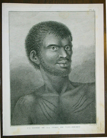
1785 Capt. Cook Antique Print Aboriginal Man of Bruny Island, Tasmania in 1777
- Title : Un Homme De La Terre De Van-Diemens
- Ref : 43195
- Size: 10in x 8in (255mm x 205mm)
- Date : 1785
- Condition: (A+) Fine Condition
Description:
This fine original copper-plate engraved antique print of an Indigenous Man of Adventure Bay, Bruny Island, Tasmania (Van Diemens Land) encountered by Captain Cook in during his 3rd & last Voyage of Discovery in 1777, was engraved by Robert Benard - after John Webber - and published in the 1785 French edition of Capt. James Cook & Capt. James King A Voyage to the Pacific Ocean. Undertaken, by the Command of his Majesty, for making Discoveries in the Northern Hemisphere. To determine The Position and Extent of the West Side of North America; its Distance from Asia; and the Practicability of a Northen Passage to Europe. Performed under the direction of Captains Cook, Clerke, and Gore, In His Majesty\'s Ships the Resolution and Discovery. In the Years 1776, 1777, 1778, 1779, and 1780. In Three Volumes. Vol. I and II written by James Cook, F.R.S. Vol. III by Captain James King, LL.D. and F.R.S. Paris, 1785.
Adventure Bay
from Cooks Journal......on the 24th (March 1777) at 3 AM we made the Coast of Van Diemen land wrote Cook. Anderson remarked that though now the middle of summer here a spot or two of snow was seen on the highest hills… At ten we passd a point supposd to be the boundary of Stone Bay where Abel Tasman anchord, i.e. Storm Bay. According to David Samwell, surgeons first mate on the Resolution, both Ships anchored in Adventure Bay in Van Diemens Land, this Bay was so called by Captn Furneaux who had anchored here in the Adventure last Voyage.
The next day Cook and Clerke sent parties, one to cut wood and the other grass. Clerke wrote of his party from the Discovery The Guard I had sent with the Parties on shore which consisted of the following Marines, Hamlet Thompson, Geo: Moody, Ben: Harriot, Jos: Pool & Willm Broom, stole some Liquor & made themselves exceedingly drunk, for which they receivd a dozen lashes each in the Morning. The Privates were all from the Plymouth division of marines. Hamlet Thompson was from the 6th Company, George Moody from the 70th, John Herriott the 12th, James Poole the 33rd and William Broom the 36th. According to Thomas Edgar, Master, they made themselves so Beastly Drunk that they were put motionless in the Boat, and when brought on board were oblig\'d to be hoisted into the Ship.
William Bayly, astronomer on the Discovery, wrote In the morning I carried my Tent observatory & Instruments on Shore & set all up, but was not able to get any observations it being cloudy all day, in the evening Capt Cook Sent for me & told me he had Altered his mind relative to his stay, & ordered me to pack all up & carry the whole on board again, as he intend[ed] to sail for New Zealand in a day or two.
John Henry Martin, seaman on the Discovery, described the natives. They have few, or no wants, & seemed perfectly Happy, if one might judge from their behaviour, for they frequently woud burst out, into the most immoderate fits of Laughter & when one Laughed every one followed his example Emediately.
General Definitions:
Paper thickness and quality: - Heavy and stable
Paper color : - off white
Age of map color: -
Colors used: -
General color appearance: -
Paper size: - 10in x 8in (255mm x 205mm)
Plate size: - 9 1/2in x 7 1/4in (240mm x 185mm)
Margins: - Min 1/2in (12mm)
Imperfections:
Margins: - None
Plate area: - None
Verso: - None
Background:
Adventure Bay is the name of both a township and a geographical feature on the eastern side of Bruny Island, Tasmania.
The first European to sight the bay was explorer Abel Tasman, who sought to anchor his vessel Heemskerck there in 1642. Instead, Heemskerck was driven back offshore by a storm, in token of which Tasman named the place Storm Bay. Captain Tobias Furneaux renamed it in March 1773, in honour of his ship HMS Adventure, which he had anchored in the bay for five days after becoming separated from Captain James Cook\'s HMS Resolution during Cook\'s second voyage to the Pacific search of Terra Australis Incognita. Furneaux\'s log made clear the bay was an excellent anchorage for resupplying vessels:....to the SW of the first watering place there is a large lagoon which I believe has plenty of fish in it for one of our Gentlemen caught upwards of 2 dozen trout, and shot a possum which was the only animal we saw. There are a great many gum trees and of a vast thickness and height, one of which measured in circumference 26 feet and the height under the branches was 20 feet.
Others among Furneaux\'s crew spotted evidence of what they believed were small deer but were more likely kangaroos. Furneaux also noted signs of an Aboriginal settlement in the form of several huts or wigwams on shore, with several bags of grass in which they carry their shellfish. - but the branches of which the huts were made were split and torn and there was not the least appearance of any people.
Reliably mapped and offering an abundance of water, fresh water and game, Adventure Bay quickly became a popular anchorage for European explorers. Cooks Resolution watered there in 1777, followed by William Bligh aboard HMS Bounty in 1788 and HMS Providence in 1792. Others who resupplied their vessels in the bay in this period included Bruni d Entrecasteaux aboard Recherché in 1792 and 1793, and Nicolas Baudin in the corvette Géographe in 1802. Matthew Flinders also tried to enter the bay with Norfolk in 1798.
John Hawkesworth 1715 – 1773 English writer and book editor.
He is said to have been clerk to an attorney, and was certainly self-educated. In 1744, he succeeded Samuel Johnson as compiler of the parliamentary debates for the Gentleman\\\'s Magazine, and from 1746 to 1749 he contributed poems signed Greville, or H Greville, to that journal. In company with Johnson and others he started a periodical called The Adventurer, which ran to 140 issues, of which 70 were from the pen of Hawkesworth himself.
On account of what was regarded as his powerful defense of morality and religion, Hawkesworth was rewarded by the archbishop of Canterbury with the degree of LL.D, In 1754–1755 he published an edition (12 vols) of Swifts works, with a life prefixed which Johnson praised in his Lives of the Poets. A larger edition (27 vols) appeared in 1766–1779. He adapted Dryden\\\'s Amphitryon for the Drury Lane stage in 1756, and Southernes Oronooko in 1759. He wrote the libretto of an oratorio Zimri in 1760, and the next year Edgar and Emmeline: a Fairy Tale was produced at Drury Lane. His Almoran and Hamet (1761) was first drafted as a play[citation needed], and a tragedy based on it by S J Pratt, The Fair Circassian (1781), met with some success.
He was commissioned by the Admiralty to edit Captain James Cooks papers relative to his first voyage. For this work, An Account of the Voyages undertaken ... for making discoveries in the Southern Hemisphere and performed by Commodore Byrone John Byron, Captain Wallis, Captain Carteret and Captain Cook (from 1702 to 1771) drawn up from the Journals ... (3 vols, 1773) Hawkesworth is said to have received from the publishers the sum of £6000. His descriptions of the manners and customs of the South Seas were, however, regarded by many critics as inexact and hurtful to the interests of morality, and the severity of their strictures is said to have hastened his death. He was buried in the parish church at Bromley, Kent, where he and his wife had kept a school.
Hawkesworth was a close imitator of Johnson both in style and thought, and was at one time on very friendly terms with him. It is said that he presumed on his success, and lost Johnsons friendship as early as 1756.
Captain James King FRS 1750 – 1784 was an officer of the Royal Navy. He served under James Cook on his last voyage around the world, specialising in taking important astronomical readings using a sextant. After Cook died he helped lead the ships on the remainder of their course, also completing Cook\\\'s account of the voyage. He continued his career in the Navy, reaching the rank of post-captain, commanding several ships and serving in the American War of Independence.
King joined HMS Resolution as second lieutenant, sharing the duties of astronomer with Cook, taking astronomical observations on board by sextant and with Larcum Kendals timekeeper K1, to establish the Resolutions position at sea and on shore by sextant or by astronomical quadrant to establish the geographical position of salient points during the course of Cooks surveys. Thus King\\\'s geographical positions were an important contribution to the accuracy of the various surveys carried out during the voyage and his use of the early chronometers helped prove their use at sea for calculation of Longitude. .
Following the death of Cook, King remained in the Resolution but on the death of Charles Clerke, Cooks successor, King was appointed to command HMS Discovery, the Resolution\\\'s consort, remaining in her for the rest of the voyage. After his return to England King was very much involved in the publication of the official account of Cooks third voyage, writing the third volume at Woodstock, near Oxford, where his brother Thomas was rector of St Mary Magdalene. But shortly after his return King was promoted Post-captain and appointed commander of HMS Crocodile in the English Channel.
John Webber RA 1751 – 1793 was an English artist who accompanied Captain Cook on his third Pacific expedition. He is best known for his images of Australasia, Hawaii and Alaska.
Webber was born in London, educated in Bern and studied painting at Paris.His father was Abraham Wäber, a Swiss sculptor who had moved to London, and changed his name to Webber before marrying a Mrs Mary Quant in 1744.
Webber served as official artist on James Cook\'s third voyage of discovery around the Pacific (1776–80) aboard HMS Resolution. At Adventure Bay in January 1777 he did drawings of A Man of Van Diemens Land and A Woman of Van Diemens Land. He also did many drawings of scenes in New Zealand and the South Sea islands. On this voyage, during which Cook lost his life in a fight in Hawaii, Webber became the first European artist to make contact with Hawaii, then called the Sandwich Islands. He made numerous watercolor landscapes of the islands of Kauai and Hawaii, and also portrayed many of the Hawaiian people.
In April 1778, Captain Cooks ships Resolution and Discovery anchored at Ship Cove, now known as Nootka Sound, Vancouver Island, Canada to refit. The crew took observations and recorded encounters with the local people. Webber made watercolour landscapes including Resolution and Discovery in Ship Cove, 1778. His drawings and paintings were engraved for British Admiraltys account of the expedition, which was published in 1784.
Back in England in 1780 Webber exhibited around 50 works at Royal Academy exhibitions between 1784 and 1792, and was elected an associate of the Royal Academy in 1785 and R.A. in 1791. Most of his work were landscapes. Sometimes figures were included as in A Party from H.M.S. Resolution shooting sea horses\", which was shown at the academy in 1784, and his The Death of Captain Cook became well known through an engraving of it. Another version of this picture is in the William Dixson gallery at Sydney
Robert Bénard 1734 – 1777 was an 18th-century French engraver.
Specialized in the technique of engraving, Robert Ménard is mainly famous for having supplied a significant amount of plates (at least 1,800) to the Encyclopédie by Diderot & d\'Alembert from 1751.
Later, publisher Charles-Joseph Panckoucke reused many of his productions to illustrate the works of his catalog.
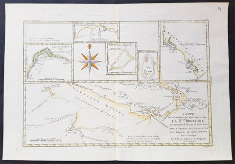
1780 Rigobert Bonne Antique Map of New Guinea, William Dampier 1699 - 5 Harbours
- Title : Carte des Decouvertes du Capt,. Carteret dans La Nlle. Bretagne..Par M Bonne
- Date : 1780
- Size: 16in x 11in (405mm x 2805mm)
- Ref #: 32155
- Condition: (A+) Fine Condition
Description:
This fine original copper plate engraved antique map of Papua New Guinea - and the early discoveries of William Dampier and the later passage of Cooks ship the Endeavor through the straits between Australia and New Guinea, by Rigobert Bonne was published in the 1780 edition of Atlas des toutes les parties connues du globe terrestre by Guillaume Raynal.
The map also contains the bays, Harbours and coastlines of several Islands of the Pacific including New Ireland, Philippines, Indonesia.(Ref Tooley M&B)
General Definitions:
Paper thickness and quality: - Heavy and stable
Paper color : - off white
Age of map color: - Early
Colors used: - Yellow, Green, pink
General color appearance: - Authentic
Paper size: - 16 ½in x 11 ½in; (420mm x 295mm)
Plate size: - 14 ½in x 10in; (370mm x 250mm)
Margins: - Min 1/2in (12mm)
Imperfections:
Margins: - None
Plate area: - None
Verso: - None
Background:
William Dampier 1651 - 1715 was an English explorer and navigator who became the first Englishman to explore parts of what is today Australia, and the first person to circumnavigate the world three times. He has also been described as Australia\'s first natural historian, as well as one of the most important British explorers of the period between Sir Walter Raleigh and James Cook.
After impressing the Admiralty with his book A New Voyage Round the World, Dampier was given command of a Royal Navy ship and made important discoveries in Western Australia, before being court-martialled for cruelty. On a later voyage he rescued Alexander Selkirk, a former crewmate who may have inspired Daniel Defoes Robinson Crusoe. Others influenced by Dampier include James Cook, Horatio Nelson, Charles Darwin, and Alfred Russel Wallace.
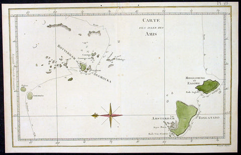
1778 Capt. Cook Antique Map HMS Resolution & Adventure in the Tonga Islands 1773
- Title : Carte Des Isles Des Amis ( Friendly Islands)
- Ref : 32166
- Size: 13 1/2in x 9in (345mm x 230mm)
- Date : 1778
- Condition: (A) Very Good Condition
Description:
This fine original copper-plate engraved antique map of the Tonga Islands with the routes taken by HMS Resolution & Adventure, during Captain James Cooks 2nd Voyage of Discovery in 1773, was engraved by Robert Benard - after Thomas Bowen - and was published in the 1778 French edition of Capt. James Cooks 2nd Voyage of Discovery to the South Seas A voyage towards the South Pole, and round the World. Performed in His Majestys ships the Resolution and Adventure, in the years 1772, 1773, 1774, and 1775..... Paris : Hotel de Thou ......1778.
Exert From Cooks diary A Voyage Towards the South Pole.........after leaving Raiatea (Society Islands) on 18 September 1773, Cook directed his course towards Amsterdam Island (Tongatapu), discovered by Tasman in 1643, intending to verify Tasmans charting against his own charts. The ships stayed for three days, thoroughly enjoying the reception they had received and called the group the Friendly Islands. On his second visit he headed for the Nomuka, the largest island of the south central group of Tonga.......
General Definitions:
Paper thickness and quality: - Heavy and stable
Paper color : - off white
Age of map color: - Early
Colors used: - Green, yellow, pink
General color appearance: - Authentic
Paper size: - 13 1/2in x 9in (345mm x 230mm)
Plate size: - 13 1/2in x 9in (345mm x 230mm)
Margins: - Min 1/2in (12mm)
Imperfections:
Margins: - Small repair in top margin/border
Plate area: - None
Verso: - None
Background:
Tonga officially the Kingdom of Tonga, is a Polynesian sovereign state and archipelago comprising 169 islands, of which 36 are inhabited. The total surface area is about 750 square kilometres (290 sq mi) scattered over 700,000 square kilometres (270,000 sq mi) of the southern Pacific Ocean. It has a population of 107,122 people, of whom 70% reside on the main island of Tongatapu.
The Tongan people first encountered Europeans in 1616 when the Dutch vessel Eendracht, captained by Willem Schouten, made a short visit to trade. Later came other Dutch explorers, including Jacob Le Maire (who called on the northern island of Niuatoputapu); and in 1643 Abel Tasman (who visited Tongatapu and Haapai).
Later noteworthy European visitors included James Cook (Royal Navy) in 1773, 1774, and 1777; Alessandro Malaspina (Spanish Navy) in 1793; the first London missionaries in 1797; and the Wesleyan Methodist Reverend Walter Lawry in 1822.
Tonga became known in the West as the Friendly Islands because of the congenial reception accorded to Captain James Cook on his first visit in 1773. He arrived at the time of the inasi festival, the yearly donation of the First Fruits to the Tui Tonga (the islands paramount chief) and so received an invitation to the festivities. According to the writer William Mariner, the chiefs wanted to kill Cook during the gathering but could not agree on a plan.
William Hodges RA 1744 – 1797 was an English painter. He was a member of James Cooks second voyage to the Pacific Ocean, and is best known for the sketches and paintings of locations he visited on that voyage, including Table Bay, Tahiti, Easter Island, and the Antarctic.
Between 1772 and 1775 Hodges accompanied James Cook to the Pacific as the expeditions artist. Many of his sketches and wash paintings were adapted as engravings in the original published edition of Cooks journals from the voyage.
Most of the large-scale landscape oil paintings from his Pacific travels for which Hodges is best known were finished after his return to London; he received a salary from the Admiralty for the purposes of completing them. These paintings depicted a stronger light and shadow than had been usual in European landscape tradition. Contemporary art critics complained that his use of light and colour contrasts gave his paintings a rough and unfinished appearance.
Hodges also produced many valuable portrait sketches of Pacific islanders and scenes from the voyage involving members of the expedition..
Robert Bénard 1734 – 1777 was an 18th-century French engraver.
Specialized in the technique of engraving, Robert Ménard is mainly famous for having supplied a significant amount of plates (at least 1,800) to the Encyclopédie by Diderot & d\'Alembert from 1751.
Later, publisher Charles-Joseph Panckoucke reused many of his productions to illustrate the works of his catalog.
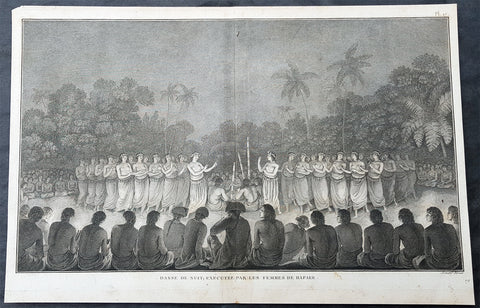
1785 Capt Cook Antique Print Woman Dancing on Lifuka Island, Haapai Tonga, 1777
- Title : Danse de Nuit, Executee par les Femmes de Hapaee (Night dance, performed by the women of Hapaee)
- Size: 15 1/2in x 10 1/2in (395mm x 265mm)
- Ref #: 21440
- Date : 1785
- Condition: (A) Very Good Condition
Description:
This fine original copper-plate engraved antique print of Captain Cook and his men watching a night dance by the local women on the island of Lifuka, one of the islands of the Haapai group of Tonga Islands, visited by Captain Cook in 1777, during his 3rd & last Voyage of Discovery, was engraved by Robert Benard - after John Webber - and was published in the 1785 French edition of Capt. James Cook & Capt. James King publication A Voyage to the Pacific Ocean. Undertaken, by the Command of his Majesty, for making Discoveries in the Northern Hemisphere. To determine The Position and Extent of the West Side of North America; its Distance from Asia; and the Practicability of a Northern Passage to Europe. Performed under the direction of Captains Cook, Clerke, and Gore, In His Majestys Ships the Resolution and Discovery. In the Years 1776, 1777, 1778, 1779, and 1780. In Three Volumes. Vol. I and II written by James Cook, F.R.S. Vol. III by Captain James King, LL.D. and F.R.S. Paris, 1785.
A scene in Lifuka, Tonga, 20 May 1777, with James Cook and officers to his left with their backs to the viewer seated amongst a circle of Tongan men and watching a large group of women performing a dance, lit by tapers held by the watchers.
.........in a short time a number of Women, dressed better than Common, came and encircled the men in a kind of dance and joined in the Song; thus they continued for a full half hour, when two elderly women (one on each side, and who seemed to have the management of the whole) brought the others up, dancing two by two and ranged them before the chief, which ended the dance and the assembly broke up. Cook Journals III, i, 100
General Definitions:
Paper thickness and quality: - Heavy and stable
Paper color : - off white
Age of map color: -
Colors used: -
General color appearance: -
Paper size: - 15 1/2in x 10 1/2in (395mm x 265mm)
Plate size: - 14 1/2in x 9 1/2in (370mm x 245mm)
Margins: - Min 1/2in (12mm)
Imperfections:
Margins: - Light soiling
Plate area: - None
Verso: - Light soiling
Background:
Lifuka is an island in the Kingdom of Tonga. It is located within the Haapai Group in the centre of the country, to northeast of the national capital of Nukualofa.
Lifuka is the place where Captain James Cook dubbed Tonga The Friendly Islands. Tofua is where the mutiny on the Bounty occurred in 1789; this active volcanic island lies approximately forty nautical miles west of Lifuka. The Cpt. Bligh voyage stands as the longest successful passage ever recorded in an open boat without modern navigational aids.
Haapai is a group of islands, islets, reefs and shoals with an area of 109.30 square kilometres in the central part of the Kingdom of Tonga, with the Tongatapu group to the south and the Vavau group to the north. Seventeen of the Ha apai islands are populated with altogether 6,616 people.
The first European to visit Ha apai, was Abel Tasman in 1643. Captain James Cook in 1774 and 1777, made several stops on the islands. He gave them the name of Friendly Islands in 1777.
On 18 May 1777, Cook arrived with Omai. They were greeted by Fatafehi Paulaho, King of the Isles or Tui Tonga, the most sacred chief in these islands.
Tonga officially the Kingdom of Tonga, is a Polynesian sovereign state and archipelago comprising 169 islands, of which 36 are inhabited. The total surface area is about 750 square kilometres (290 sq mi) scattered over 700,000 square kilometres (270,000 sq mi) of the southern Pacific Ocean. It has a population of 107,122 people, of whom 70% reside on the main island of Tongatapu.
The Tongan people first encountered Europeans in 1616 when the Dutch vessel Eendracht, captained by Willem Schouten, made a short visit to trade. Later came other Dutch explorers, including Jacob Le Maire (who called on the northern island of Niuatoputapu); and in 1643 Abel Tasman (who visited Tongatapu and Haapai).
Later noteworthy European visitors included James Cook (Royal Navy) in 1773, 1774, and 1777; Alessandro Malaspina (Spanish Navy) in 1793; the first London missionaries in 1797; and the Wesleyan Methodist Reverend Walter Lawry in 1822.
Tonga became known in the West as the Friendly Islands because of the congenial reception accorded to Captain James Cook on his first visit in 1773. He arrived at the time of the inasi festival, the yearly donation of the First Fruits to the Tui Tonga (the islands paramount chief) and so received an invitation to the festivities. According to the writer William Mariner, the chiefs wanted to kill Cook during the gathering but could not agree on a plan.
Captain James King FRS 1750 – 1784 was an officer of the Royal Navy. He served under James Cook on his last voyage around the world, specialising in taking important astronomical readings using a sextant. After Cook died he helped lead the ships on the remainder of their course, also completing Cooks account of the voyage. He continued his career in the Navy, reaching the rank of post-captain, commanding several ships and serving in the American War of Independence.
King joined HMS Resolution as second lieutenant, sharing the duties of astronomer with Cook, taking astronomical observations on board by sextant and with Larcum Kendals timekeeper K1, to establish the Resolutions position at sea and on shore by sextant or by astronomical quadrant to establish the geographical position of salient points during the course of Cooks surveys. Thus Kings geographical positions were an important contribution to the accuracy of the various surveys carried out during the voyage and his use of the early chronometers helped prove their use at sea for calculation of Longitude. .
Following the death of Cook, King remained in the Resolution but on the death of Charles Clerke, Cooks successor, King was appointed to command HMS Discovery, the Resolutions consort, remaining in her for the rest of the voyage. After his return to England King was very much involved in the publication of the official account of Cooks third voyage, writing the third volume at Woodstock, near Oxford, where his brother Thomas was rector of St Mary Magdalene. But shortly after his return King was promoted Post-captain and appointed commander of HMS Crocodile in the English Channel.
John Webber RA 1751 – 1793 was an English artist who accompanied Captain Cook on his third Pacific expedition. He is best known for his images of Australasia, Hawaii and Alaska.
Webber was born in London, educated in Bern and studied painting at Paris.His father was Abraham Wäber, a Swiss sculptor who had moved to London, and changed his name to Webber before marrying a Mrs Mary Quant in 1744.
Webber served as official artist on James Cooks third voyage of discovery around the Pacific (1776–80) aboard HMS Resolution. At Adventure Bay in January 1777 he did drawings of A Man of Van Diemens Land and A Woman of Van Diemens Land. He also did many drawings of scenes in New Zealand and the South Sea islands. On this voyage, during which Cook lost his life in a fight in Hawaii, Webber became the first European artist to make contact with Hawaii, then called the Sandwich Islands. He made numerous watercolor landscapes of the islands of Kauai and Hawaii, and also portrayed many of the Hawaiian people.
In April 1778, Captain Cooks ships Resolution and Discovery anchored at Ship Cove, now known as Nootka Sound, Vancouver Island, Canada to refit. The crew took observations and recorded encounters with the local people. Webber made watercolour landscapes including Resolution and Discovery in Ship Cove, 1778. His drawings and paintings were engraved for British Admiraltys account of the expedition, which was published in 1784.
Back in England in 1780 Webber exhibited around 50 works at Royal Academy exhibitions between 1784 and 1792, and was elected an associate of the Royal Academy in 1785 and R.A. in 1791. Most of his work were landscapes. Sometimes figures were included as in A Party from H.M.S. Resolution shooting sea horses, which was shown at the academy in 1784, and his The Death of Captain Cook became well known through an engraving of it. Another version of this picture is in the William Dixson gallery at Sydney
Robert Bénard 1734 – 1777 was an 18th-century French engraver.
Specialized in the technique of engraving, Robert Ménard is mainly famous for having supplied a significant amount of plates (at least 1,800) to the Encyclopédie by Diderot & d Alembert from 1751.
Later, publisher Charles-Joseph Panckoucke reused many of his productions to illustrate the works of his catalog.
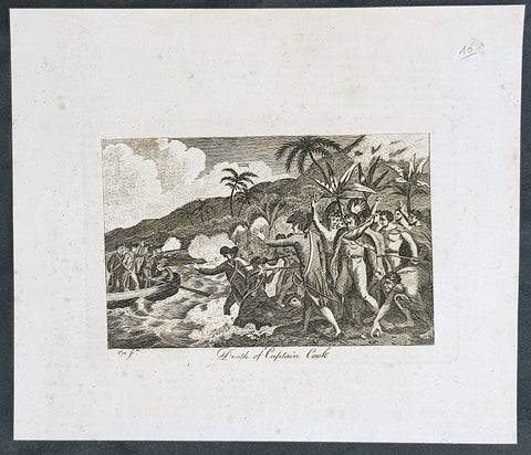
1799 Charles Pye Antique Print of The Death of Captain James Cook in Hawaii 1779
- Title : Death of Captain Cook....Pye Sch.
- Size: 9in x 7 1/2in (230mm x 180mm)
- Condition: (A+) Fine Condition
- Date : 1799
- Ref #: 01-7134-1
Description:
This original copper-plate engraved naive and early print of the Death of Captain Cook in Hawaii in 1779 was engarved by Charles Pye and published in 1799.
General Definitions:
Paper thickness and quality: - Heavy and stable
Paper color : - off white
Age of map color: -
Colors used: -
General color appearance: -
Paper size: - 9in x 7 1/2in (230mm x 180mm)
Plate size: - 6 1/2in x 4 1/2in (165mm x 115mm)
Margins: - Min 1in (25mm)
Imperfections:
Margins: - Light soiling
Plate area: - None
Verso: - Light soiling
Background:
Captain James Cook 1728 – 1779 was a British explorer, navigator, cartographer, and captain in the Royal Navy. Cook made detailed maps of Newfoundland prior to making three voyages to the Pacific Ocean, during which he achieved the first recorded European contact with the eastern coastline of Australia and the Hawaiian Islands, and the first recorded circumnavigation of New Zealand.
Cook joined the British merchant navy as a teenager and joined the Royal Navy in 1755. He saw action in the Seven Years War and subsequently surveyed and mapped much of the entrance to the Saint Lawrence River during the siege of Quebec. This helped bring Cook to the attention of the Admiralty and Royal Society. This acclaim came at a crucial moment in both Cook\'s career and the direction of British overseas exploration, and led to his commission in 1766 as commander of HM Bark Endeavour for the first of three Pacific voyages.
In three voyages, Cook sailed thousands of miles across largely uncharted areas of the globe. He mapped lands from New Zealand to Hawaii in the Pacific Ocean in greater detail and on a scale not previously achieved. As he progressed on his voyages of discovery, he surveyed and named features, and he recorded islands and coastlines on European maps for the first time. He displayed a combination of seamanship, superior surveying and cartographic skills, physical courage, and an ability to lead men in adverse conditions.
Cook was attacked and killed in 1779 during his third exploratory voyage in the Pacific while attempting to kidnap Kalani ōpu u, a Hawaiian chief, in order to reclaim a cutter stolen from one of his ships. He left a legacy of scientific and geographical knowledge which influenced his successors well into the 20th century, and numerous memorials worldwide have been dedicated to him.
Pye, Charles Jr. 1775–1864
Pye was an English engraver from Birmingham. He was the elder son of Charles Pye Sr. an engraver in Birmingham, and the brother of landscape engraver John Pye. He was also a pupil of James Heath.
During his later years, Pye lived in Leamington. A trade card (proof before engraved letters) is in the Heal Collection (Heal,59.124) and advertises C. Pye Engraver, No.14 Charton St. Sommerstown.
Pyes engravings were published in collections including:
- Beauties of England Illustrated
- Hunters History of London
- Cadell & Davies, Britannia depicta.
- J. Scott and P. B. de la Boissière, Picturesque Views of the City of Paris and its Environs (1823)
Pye supplied engravings to designs by William Westall for the early issues of John Poole\\\'s The Regent, Or, Royal Tablet of Memory. In 1820 he published a letter, from Euston Square, on his experiments with relief etching on copper, in The London Journal of Arts and Sciences
1865 George Frederick Sargent Antique Print View of Sydney across the Harbour
- Title : Sydney....G F Sargent....G Greatbach....William Mackenzie; London, Edinburgh & Glasgow
- Ref #: 35518
- Size: 10in x 6 1/2in (255mm x 165mm)
- Date : 1864
- Condition: (A+) Fine Condition
Description:
This hand coloured original steel-plate engraved antique print of Sydney NSW, north across the Rocks with a view to St James Church on Kings St, across the harbour where the Harbour Bridge now sits, after the Australian artist George Frederick Sargent in 1859 was engraved by G. Greatbach and published by William Mackenzie and co. in 1865.
General Definitions:
Paper thickness and quality: - Heavy and stable
Paper color : - off white
Age of map color: - Early
Colors used: - Yellow, green, blue, pink
General color appearance: - Authentic
Paper size: - 25in x 21 1/4in (635mm x 540mm)
Plate size: - 23in x 19 1/2in (590mm x 500mm)
Margins: - Min 1/2in (12mm)
Imperfections:
Margins: - Small repair to top margin, no loss
Plate area: - None
Verso: - None
Background:
The History of Sydney begins in prehistoric times with the occupation of the district by Australian Aborigines, whose ancestors came to Sydney in the Upper Paleolithic period. The modern history of the city began with the arrival of a First Fleet of British ships in 1788 and the foundation of a penal colony by Great Britain.
From 1788 to 1900 Sydney was the capital of the British colony of New South Wales. An elected city council was established in 1840. In 1900, Sydney became a state capital, when New South Wales voted to join the Australian Federation. Sydney today is Australias largest city and a major international capital of culture and finance.
Mackenzie, William active 1860-70
William Mackenzie, Ludgate Hill, London, Edinburgh and Glasgow, was a well-known publisher of natural history books in the 1860s & 70s. He published works by the trio of Francis Orpen Morris, Benjamin Fawcett and Alexander Francis Lydon. His best-known publication was probably County Seats of The Noblemen and Gentlemen of Great Britain and Ireland in 1870
1825 Philippe Vandermaelen Large Antique Map of Vanuatu, South Pacific, Hebrides
-
Title : Archipel Des Nlles Hebrides
- Ref #: 17002
-
Condition: (A+) Fine Condition
- Size: 28 1/2in x 21in (725mm x 550mm)
- Date : 1825
Description:
This very large original hand coloured antique lithograph map of the New Hebrides Islands, now know as Vanuatu, in the South Pacific was published by Philippe Vandermaelen in his revolutionary 1825 Atlas universel de geographie physique, politique, statistique et mineralogique.
Until the publication of this atlas, large detailed maps of this region of Australia & the Pacific were uncommon.
General Definitions:
Paper thickness and quality: - Heavy and stable
Paper color : - off white
Age of map color: - Early
Colors used: - Red, yellow, green, blue
General color appearance: - Authentic
Paper size: - 28 1/2in x 21in (725mm x 550mm)
Plate size: - 28 1/2in x 21in (725mm x 550mm)
Margins: - Min 1/2in (12mm)
Imperfections:
Margins: - None
Plate area: - None
Verso: - None
Background:
New Hebrides, officially the New Hebrides Condominium (French: Condominium des Nouvelles-Hébrides, lit. Condominium of the New Hebrides) and named for the Hebrides Scottish archipelago, was the colonial name for the island group in the South Pacific Ocean that is now Vanuatu. Native people had inhabited the islands for three thousand years before the first Europeans arrived in 1606 from a Spanish expedition led by Portuguese navigator Pedro Fernandes de Queirós. The islands were colonised by both the British and French in the 18th century, shortly after Captain James Cook visited.
The two countries eventually signed an agreement making the islands an Anglo-French condominium that divided New Hebrides into two separate communities: one Anglophone and one Francophone. That divide continued even after independence, with schools teaching in either one language or the other, and with different political parties. The condominium lasted from 1906 until 1980, when New Hebrides gained its independence as the Republic of Vanuatu.
Vandermaelen, Philippe M G 1795-1869
Vandermaelen was the son of the wealthy soap manufacturer; he abandoned the soap trade and devoted his life to cartography. Entirely self-taught in geometry, astronomy and the geosciences, he began drafting the first sheets of an Atlas universel in 1824. This atlas was published between 1825 and 1827; it was sold in forty instalments of ten maps each and became a great success. The revenue enabled him to set up his own Etablissement géographique de Bruxelles in 1830, which not only produced maps, atlases and globes in large quantities but also housed a natural science museum, botanical gardens, a library, and an impressive collection of maps.
Shortly after the closing of Vandermaelens Institute, the Royal Library of Belgium (KBR) in 1880 acquired a large part of its cartographic collection and production.
Vandermaelens atlas was remarkable: 387 maps on a uniform scale of ca. 1:1.6 million. There was one edition of this very rare atlas, published in 1825-27; the subscription list shows that only 810 copies were sold. The six volumes, of which Africa was in Volume III (60 maps), were issued in instalments during the period 1825-1827.
This folio-size atlas is remarkable for several reasons. It is the first atlas produced by the then new printing process of lithography. It is also the first atlas to show the whole world in 380 maps using a large uniform scale—about 10km to the cm. on a modified conical projection described by Sanson-Flamsteed. Based on a prime meridian through Paris, each map has a drawn-out graticule giving it a trapezoidal form, the underlying intention being construction of a globe with a diameter of 7.755m Eugene Gilbert de Cauwer , his biographer, suggested that Vandernaelen was a worthy follower of Mercator and Ortelius.
Vandermaelen enlisted the assistance of lithographer-printer Hippolyte Ode in this ambitious project which introduced lithography into Belgium and created an upsurge in Belgian publishing. A number of maps were lithographed by Philippe Vandermaelen himself. For many of the areas depicted, these maps are the largest scale maps made at the time, and the most detailed. The lithographs are very well drawn and printed and should be appreciated in the context of lithography, which was a developing art at the time. The maps are handsome and detailed, although some of the place names are somewhat curious and the cartography sometimes imaginary. Nevertheless, the Vandermaelen maps are of great significance in the history of cartography and lithography. Visually, they are arresting and unusual. Vandermaelens maps best are appreciated in the context of its neighbouring maps - they were all meant to be joined .
Please note all items auctioned are genuine, we do not sell reproductions. A Certificate of Authenticity (COA) can be issued on request.

1825 Philippe Vandermaelen Large Antique Map Admiralty or Manus Islands Pacific
-
Title : Iles De L Amiraute
- Ref #: 17005
-
Condition: (A+) Fine Condition
- Size: 28 1/2in x 21in (725mm x 550mm)
- Date : 1825
Description:
This very large original hand coloured antique lithograph map of the Admiralty or Manus Islands, north of New Guinea, in the South Pacific was published by Philippe Vandermaelen in his revolutionary 1825 Atlas universel de geographie physique, politique, statistique et mineralogique.
Until the publication of this atlas, large detailed maps of this region of Australia & the Pacific were uncommon.
General Definitions:
Paper thickness and quality: - Heavy and stable
Paper color : - off white
Age of map color: - Early
Colors used: - Red, yellow, green, blue
General color appearance: - Authentic
Paper size: - 28 1/2in x 21in (725mm x 550mm)
Plate size: - 28 1/2in x 21in (725mm x 550mm)
Margins: - Min 1/2in (12mm)
Imperfections:
Margins: - None
Plate area: - None
Verso: - None
Background:
The first European to visit the islands was the Spanish navigator Álvaro de Saavedra when trying to return from Tidore to New Spain in the summer of 1528. Saavedra charted Manus as Urays la Grande. Its visit was also reported in 1616 by the Dutch navigator Willem Schouten. The name Admiralty Islands was devised by Captain Philip Carteret of the British Royal Navy in 1767.
Between 1884 and 1914 the area was administered as a German colony. In November 1914, the islands were occupied by troops of the Australian Naval and Military Expeditionary Force landed from the SS Siar. A few shots fired from a machine gun on Siar over the heads of the tiny German garrison at Lorengau were the last shots fired in the battle. After the war, the islands were governed by the Commonwealth of Australia under a League of Nations mandate.
Japanese troops landed on Manus Island on 7 April 1942. In 1944, Japanese forces occupying the islands were attacked and defeated by Allied forces in Operation Brewer. Subsequently, a large American airbase was built at Lombrum near Lorengau.
Vandermaelen, Philippe M G 1795-1869
Vandermaelen was the son of the wealthy soap manufacturer; he abandoned the soap trade and devoted his life to cartography. Entirely self-taught in geometry, astronomy and the geosciences, he began drafting the first sheets of an Atlas universel in 1824. This atlas was published between 1825 and 1827; it was sold in forty instalments of ten maps each and became a great success. The revenue enabled him to set up his own Etablissement géographique de Bruxelles in 1830, which not only produced maps, atlases and globes in large quantities but also housed a natural science museum, botanical gardens, a library, and an impressive collection of maps.
Shortly after the closing of Vandermaelens Institute, the Royal Library of Belgium (KBR) in 1880 acquired a large part of its cartographic collection and production.
Vandermaelens atlas was remarkable: 387 maps on a uniform scale of ca. 1:1.6 million. There was one edition of this very rare atlas, published in 1825-27; the subscription list shows that only 810 copies were sold. The six volumes, of which Africa was in Volume III (60 maps), were issued in instalments during the period 1825-1827.
This folio-size atlas is remarkable for several reasons. It is the first atlas produced by the then new printing process of lithography. It is also the first atlas to show the whole world in 380 maps using a large uniform scale—about 10km to the cm. on a modified conical projection described by Sanson-Flamsteed. Based on a prime meridian through Paris, each map has a drawn-out graticule giving it a trapezoidal form, the underlying intention being construction of a globe with a diameter of 7.755m Eugene Gilbert de Cauwer , his biographer, suggested that Vandernaelen was a worthy follower of Mercator and Ortelius.
Vandermaelen enlisted the assistance of lithographer-printer Hippolyte Ode in this ambitious project which introduced lithography into Belgium and created an upsurge in Belgian publishing. A number of maps were lithographed by Philippe Vandermaelen himself. For many of the areas depicted, these maps are the largest scale maps made at the time, and the most detailed. The lithographs are very well drawn and printed and should be appreciated in the context of lithography, which was a developing art at the time. The maps are handsome and detailed, although some of the place names are somewhat curious and the cartography sometimes imaginary. Nevertheless, the Vandermaelen maps are of great significance in the history of cartography and lithography. Visually, they are arresting and unusual. Vandermaelens maps best are appreciated in the context of its neighbouring maps - they were all meant to be joined .
Please note all items auctioned are genuine, we do not sell reproductions. A Certificate of Authenticity (COA) can be issued on request.

1825 Philippe Vandermaelen Large Antique Map of Austral Islands French Polynesia
-
Title : Partie De L Archipel Des Iles Basses
- Ref #: 17006
-
Condition: (A+) Fine Condition
- Size: 28 1/2in x 21in (725mm x 550mm)
- Date : 1825
Description:
This very large original hand coloured antique lithograph map of the Austral Islands in the French Polynesia group of islands in the in the South Pacific was published by Philippe Vandermaelen in his revolutionary 1825 Atlas universel de geographie physique, politique, statistique et mineralogique.
Until the publication of this atlas, large detailed maps of this region of Australia & the Pacific were uncommon.
General Definitions:
Paper thickness and quality: - Heavy and stable
Paper color : - off white
Age of map color: - Early
Colors used: - Red, yellow, green, blue
General color appearance: - Authentic
Paper size: - 28 1/2in x 21in (725mm x 550mm)
Plate size: - 28 1/2in x 21in (725mm x 550mm)
Margins: - Min 1/2in (12mm)
Imperfections:
Margins: - None
Plate area: - None
Verso: - None
Background:
New Hebrides, officially the New Hebrides Condominium (French: Condominium des Nouvelles-Hébrides, lit. Condominium of the New Hebrides) and named for the Hebrides Scottish archipelago, was the colonial name for the island group in the South Pacific Ocean that is now Vanuatu. Native people had inhabited the islands for three thousand years before the first Europeans arrived in 1606 from a Spanish expedition led by Portuguese navigator Pedro Fernandes de Queirós. The islands were colonised by both the British and French in the 18th century, shortly after Captain James Cook visited.
The two countries eventually signed an agreement making the islands an Anglo-French condominium that divided New Hebrides into two separate communities: one Anglophone and one Francophone. That divide continued even after independence, with schools teaching in either one language or the other, and with different political parties. The condominium lasted from 1906 until 1980, when New Hebrides gained its independence as the Republic of Vanuatu.
Vandermaelen, Philippe M G 1795-1869
Vandermaelen was the son of the wealthy soap manufacturer; he abandoned the soap trade and devoted his life to cartography. Entirely self-taught in geometry, astronomy and the geosciences, he began drafting the first sheets of an Atlas universel in 1824. This atlas was published between 1825 and 1827; it was sold in forty instalments of ten maps each and became a great success. The revenue enabled him to set up his own Etablissement géographique de Bruxelles in 1830, which not only produced maps, atlases and globes in large quantities but also housed a natural science museum, botanical gardens, a library, and an impressive collection of maps.
Shortly after the closing of Vandermaelens Institute, the Royal Library of Belgium (KBR) in 1880 acquired a large part of its cartographic collection and production.
Vandermaelens atlas was remarkable: 387 maps on a uniform scale of ca. 1:1.6 million. There was one edition of this very rare atlas, published in 1825-27; the subscription list shows that only 810 copies were sold. The six volumes, of which Africa was in Volume III (60 maps), were issued in instalments during the period 1825-1827.
This folio-size atlas is remarkable for several reasons. It is the first atlas produced by the then new printing process of lithography. It is also the first atlas to show the whole world in 380 maps using a large uniform scale—about 10km to the cm. on a modified conical projection described by Sanson-Flamsteed. Based on a prime meridian through Paris, each map has a drawn-out graticule giving it a trapezoidal form, the underlying intention being construction of a globe with a diameter of 7.755m Eugene Gilbert de Cauwer , his biographer, suggested that Vandernaelen was a worthy follower of Mercator and Ortelius.
Vandermaelen enlisted the assistance of lithographer-printer Hippolyte Ode in this ambitious project which introduced lithography into Belgium and created an upsurge in Belgian publishing. A number of maps were lithographed by Philippe Vandermaelen himself. For many of the areas depicted, these maps are the largest scale maps made at the time, and the most detailed. The lithographs are very well drawn and printed and should be appreciated in the context of lithography, which was a developing art at the time. The maps are handsome and detailed, although some of the place names are somewhat curious and the cartography sometimes imaginary. Nevertheless, the Vandermaelen maps are of great significance in the history of cartography and lithography. Visually, they are arresting and unusual. Vandermaelens maps best are appreciated in the context of its neighbouring maps - they were all meant to be joined .
Please note all items auctioned are genuine, we do not sell reproductions. A Certificate of Authenticity (COA) can be issued on request.

1825 Philippe Vandermaelen Large Antique Map of The Solomon Islands
- Title : Oceanique. Partie Des Iles Salomon
- Ref #: 17003
- Size: 28 1/2in x 21in (725mm x 550mm)
- Date : 1825
- Condition: (A+) Fine Condition
Description:
This very large original hand coloured antique lithograph map of the Solomon Islands in the South Pacific was published by Philippe Vandermaelen in his revolutionary 1825 Atlas universel de geographie physique, politique, statistique et mineralogique.
Until the publication of this atlas, large detailed maps of this region of Australia & the Pacific were uncommon.
General Definitions:
Paper thickness and quality: - Heavy and stable
Paper color : - off white
Age of map color: - Original
Colors used: - Yellow, green, blue, pink
General color appearance: - Authentic
Paper size: - 28 1/2in x 21in (725mm x 550mm)
Plate size: - 28 1/2in x 21in (725mm x 550mm)
Margins: - Min 1/2in (12mm)
Imperfections:
Margins: - None
Plate area: - None
Verso: - None
Background:
The first European to visit the islands was the Spanish navigator Álvaro de Mendaña de Neira, sailing from Peru in 1568. Landing on Santa Isabel on 7 February, Mendaña explored several of the other islands including Makira, Guadalcanal and Malaita. Relations with the native Solomon Islanders were initially cordial, though often soured as time went by. As a result, Mendaña returned to Peru in August 1568. He returned to the Solomons with a larger crew on a second voyage in 1595, aiming to colonise the islands. They landed on Nendö in the Santa Cruz Islands and established a small settlement at Gracioso Bay. However the settlement failed due to poor relations with the native peoples and epidemics of disease amongst the Spanish which caused numerous deaths, with Mendaña himself dying in October. The new commander Pedro Fernandes de Queirós thus decided to abandon the settlement and they sailed north to the Spanish territory of the Philippines. Queirós later returned to the area in 1606, where he sighted Tikopia and Taumako, though this voyage was primarily to Vanuatu in the search of Terra Australis.
Save for Abel Tasmans sighting of the remote Ontong Java Atoll in 1648, no European sailed to the Solomons again until 1767, when the British explorer Philip Carteret sailed by the Santa Cruz Islands, Malaita and, continuing further north, Bougainville and the Bismarck Islands. French explorers also reached the Solomons, with Louis Antoine de Bougainville naming Choiseul in 1768 and Jean-François-Marie de Surville exploring the islands in 1769. In 1788 John Shortland, captaining a supply ship for Britains new Australian colony at Botany Bay, sighted the Treasury and Shortland Islands. That same year the French explorer Jean-François de La Pérouse was wrecked on Vanikoro; a rescue expedition led by Bruni dEntrecasteaux sailed to Vanikoro but found no trace of La Pérouse. The fate of La Pérouse was not confirmed until 1826, when the English merchant Peter Dillon visited Tikopia and discovered items belonging to La Pérouse in the possession of the local people, confirmed by the subsequent voyage of Jules Dumont dUrville in 1828.
Some of the earliest regular foreign visitors to the islands were whaling vessels from Britain, the United States and Australia. They came for food, wood and water from late in the 18th century, establishing a trading relationship with the Solomon Islanders and later taking aboard islanders to serve as crewmen on their ships. Relations between the islanders and visiting seamen was not always good and sometimes there was bloodshed. A knock-on effect of the greater European contact was the spread of diseases to which local peoples had no immunity, as well a shift in the balance of power between coastal groups, who had access to European weapons and technology, and inland groups who did not. In the second half of the 1800s more traders arrived seeking turtleshells, sea cucumbers, copra and sandalwood, occasionally establishing semi-permanent trading stations. However initial attempts at more long-term settlement, such as Benjamin Boyds colony on Guadalcanal in 1851, were unsuccessful.
Vandermaelen, Philippe M G 1795-1869
Vandermaelen was the son of the wealthy soap manufacturer; he abandoned the soap trade and devoted his life to cartography. Entirely self-taught in geometry, astronomy and the geosciences, he began drafting the first sheets of an Atlas universel in 1824. This atlas was published between 1825 and 1827; it was sold in forty instalments of ten maps each and became a great success. The revenue enabled him to set up his own Etablissement géographique de Bruxelles in 1830, which not only produced maps, atlases and globes in large quantities but also housed a natural science museum, botanical gardens, a library, and an impressive collection of maps.
Shortly after the closing of Vandermaelens Institute, the Royal Library of Belgium (KBR) in 1880 acquired a large part of its cartographic collection and production.
Vandermaelens atlas was remarkable: 387 maps on a uniform scale of ca. 1:1.6 million. There was one edition of this very rare atlas, published in 1825-27; the subscription list shows that only 810 copies were sold. The six volumes, of which Africa was in Volume III (60 maps), were issued in instalments during the period 1825-1827.
This folio-size atlas is remarkable for several reasons. It is the first atlas produced by the then new printing process of lithography. It is also the first atlas to show the whole world in 380 maps using a large uniform scale—about 10km to the cm. on a modified conical projection described by Sanson-Flamsteed. Based on a prime meridian through Paris, each map has a drawn-out graticule giving it a trapezoidal form, the underlying intention being construction of a globe with a diameter of 7.755m Eugene Gilbert de Cauwer , his biographer, suggested that Vandernaelen was a worthy follower of Mercator and Ortelius.
Vandermaelen enlisted the assistance of lithographer-printer Hippolyte Ode in this ambitious project which introduced lithography into Belgium and created an upsurge in Belgian publishing. A number of maps were lithographed by Philippe Vandermaelen himself. For many of the areas depicted, these maps are the largest scale maps made at the time, and the most detailed. The lithographs are very well drawn and printed and should be appreciated in the context of lithography, which was a developing art at the time. The maps are handsome and detailed, although some of the place names are somewhat curious and the cartography sometimes imaginary. Nevertheless, the Vandermaelen maps are of great significance in the history of cartography and lithography. Visually, they are arresting and unusual. Vandermaelens maps best are appreciated in the context of its neighbouring maps - they were all meant to be joined .
Please note all items auctioned are genuine, we do not sell reproductions. A Certificate of Authenticity (COA) can be issued on request.
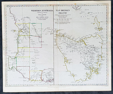
1833 SDUK Antique Map of Western Australia & Van Diemens Island, Tasmania
- Title : Western Australia containing the settlment of Swan River and King Georges Sound; Van-Diemens Land
- Size: 16 1/4in x 13 1/2in (410mm x 350mm)
- Condition: (A+) Fine Condition
- Date : 1833
- Ref #: 11-1084
Description:
This fine hand coloured original steel plate engraved antique maps of Western Australia - only 4 years after the first British settlement on the Swan river & Van Diemens Land or Tasmania was engraved by J & C Walker, in 1833 and was published in the Charles Knight edition of the Society For the Diffusion of Useful Knowledge (SDUK) Atlas.
General Definitions:
Paper thickness and quality: - Heavy and stable
Paper color : - off white
Age of map color: - Original
Colors used: - Yellow, Green, pink
General color appearance: - Authentic
Paper size: - 16 1/4in x 13 1/2in (410mm x 350mm)
Plate size: - 16 1/4in x 13 1/2in (410mm x 350mm)
Margins: - Min 1/2in (12mm)
Imperfections:
Margins: - None
Plate area: - None
Verso: - None
Background:
The SDUK produced two landmark volumes of cartography in the first half of the 19th century. The first volume concentrated on areas of the old world, Europe, Africa, Great Britain etc. The second volume contained maps of the new world, Alvin Jewett JohnsonAmerica, South Asia, including US state maps, colonies of Australia, South Africa, South America etc. Also included were some of the finest engraved town and city plans published at that time.
The SDUK was published in its entirety or in part by many publishers including Baldwin and Cradock 1829-32, Chapman & Hall in 1844, Charles Knight & co. 1846 – 1852. G. Cox published the SDUK between 1852-3, Stanford 1857-70 and later revised edition were also published after Stanford. (Ref: Tooley, M&B)
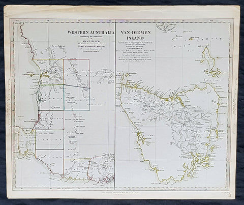
1833 SDUK Antique Map of Western Australia & Van Diemens Island, Tasmania
- Title : Western Australia containing the settlment of Swan River and King Georges Sound; Van-Diemens Land
- Size: 16 1/4in x 13 1/2in (410mm x 350mm)
- Condition: (A+) Fine Condition
- Date : 1833
- Ref #: 11-1074
Description:
This fine hand coloured original steel plate engraved antique maps of Western Australia - only 4 years after the first British settlement on the Swan river & Van Diemens Land or Tasmania was engraved by J & C Walker, in 1833 - the date is engraved at the foot of the map - and was published in the Baldwin & Craddock edition of the Society For the Diffusion of Useful Knowledge (SDUK) Atlas.
General Definitions:
Paper thickness and quality: - Heavy and stable
Paper color : - off white
Age of map color: - Original
Colors used: - Yellow, Green, pink
General color appearance: - Authentic
Paper size: - 16 1/4in x 13 1/2in (410mm x 350mm)
Plate size: - 16 1/4in x 13 1/2in (410mm x 350mm)
Margins: - Min 1/2in (12mm)
Imperfections:
Margins: - None
Plate area: - None
Verso: - None
Background:
The SDUK produced two landmark volumes of cartography in the first half of the 19th century. The first volume concentrated on areas of the old world, Europe, Africa, Great Britain etc. The second volume contained maps of the new world, Alvin Jewett JohnsonAmerica, South Asia, including US state maps, colonies of Australia, South Africa, South America etc. Also included were some of the finest engraved town and city plans published at that time.
The SDUK was published in its entirety or in part by many publishers including Baldwin and Cradock 1829-32, Chapman & Hall in 1844, Charles Knight & co. 1846 – 1852. G. Cox published the SDUK between 1852-3, Stanford 1857-70 and later revised edition were also published after Stanford. (Ref: Tooley, M&B)
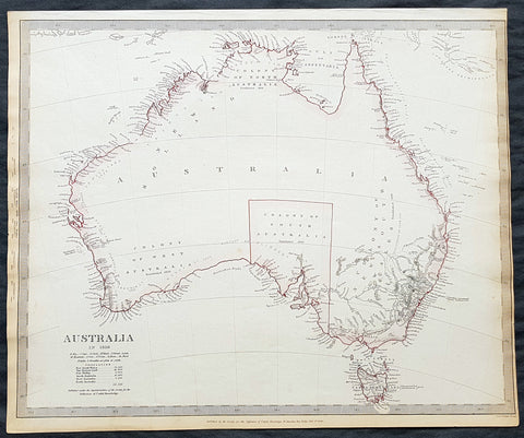
1840 SDUK Antique Map of Australia in 1839 with Population census, Colony of SA
- Title : Australia in 1839....Published by the Society of the Diffusion of Knowledge....1840
- Size: 16in x 14in (410mm x 355m)
- Condition: (A+) Fine Condition
- Date : 1840
- Ref #: 11-0924
Description:
This fine hand coloured original antique map of Australia showing the boundary of the first Australian Sate - South Australia - with a Population census of all the white people residing in Australia at the time, totaling 141,000 - was engraved by J & C Walker, in 1840 - the date is engraved at the foot of the map - and was published in the Baldwin & Craddock edition of the Society For the Diffusion of Useful Knowledge (SDUK) Atlas.
General Definitions:
Paper thickness and quality: - Heavy and stable
Paper color : - off white
Age of map color: - Original
Colors used: - Red, pink
General color appearance: - Authentic
Paper size: - 16in x 14in (410mm x 355m)
Plate size: - 16in x 14in (410mm x 355m)
Margins: - Min 1/8in (2mm)
Imperfections:
Margins: - Light age toning
Plate area: - None
Verso: - None
Background:
The SDUK produced two landmark volumes of cartography in the first half of the 19th century. The first volume concentrated on areas of the old world, Europe, Africa, Great Britain etc. The second volume contained maps of the new world, America, South Asia, including US state maps, colonies of Australia, South Africa, South America etc. Also included were some of the finest engraved town and city plans published at that time.
The SDUK was published in its entirety or in part by many publishers including Baldwin and Cradock 1829-32, Chapman & Hall in 1844, Charles Knight & co. 1846 – 1852. G. Cox published the SDUK between 1852-3, Stanford 1857-70 and later revised edition were also published after Stanford. (Ref: Tooley, M&B)
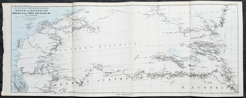
1876 Petermann Antique Map Western & South Australia - Warburton, Giles, Forrest
- Title : Die Neuesten Entdeckungsreisen im Inner-Australien von Warburton, Giles, Forrest, April 1873 - Sept 1874
- Size: 27in x 11in (285mm x 280mm)
- Condition: (A+) Fine Condition
- Date : 1876
- Ref #: 82055
Description:
This early folding original antique lithograph map of Western & South Australia and Alexandria land (Northern Territory) with the tracks of 3 explorers - in 1873 & 1874 - Peter Egerton-Warburton, Ernest Giles & Alexander Forrest by Augustus Heinrich Petermann was engraved in 1876 - dated - and was published by Justus Perthes, Gotha Germany.
General Definitions:
Paper thickness and quality: - Heavy and stable
Paper color : - off white
Age of map color: - Original
Colors used: - Blue, red, yellow
General color appearance: - Authentic
Paper size: - 27in x 11in (285mm x 280mm)
Plate size: - 27in x 11in (285mm x 280mm)
Margins: - Min 1/2in (12mm)
Imperfections:
Margins: - None
Plate area: - Folds as issued
Verso: - None
Background:
Colonel Peter Egerton-Warburton CMG (1813–1889), was a British military officer, Commissioner of Police for South Australia, and an Australian explorer. In 1872 he sealed his legacy through a particularly epic expedition from Adelaide crossing the arid centre of Australia to the coast of Western Australia via Alice Springs.
William Ernest Powell Giles (1835 – 1897) best known as Ernest Giles, was an Australian explorer who led five major expeditions in central Australia.
Alexander Forrest CMG (1849 – 1901) was an explorer and surveyor of Western Australia, and later also a member of parliament.
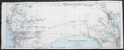
1876 Petermann Antique Map Expedition Ernest Giles Western & South Australia, 1875
- Title : Thomas Elders Expedition durch Inner-Australien vom Beltana im Osten bis Perth im Westen, Ausgefuhrt Durch E. Giles Mai - Nov 1875
- Size: 27in x 11in (285mm x 280mm)
- Condition: (A+) Fine Condition
- Date : 1876
- Ref #: 82054
Description:
This early folding original antique lithograph map of Western & South Australia - from Perth to Lake Torrens South Australia covering the 3rd & 4th expedition of the explorer Ernest Giles in 1875 by Augustus Heinrich Petermann was engraved in 1877 - dated - and was published by Justus Perthes, Gotha Germany.
General Definitions:
Paper thickness and quality: - Heavy and stable
Paper color : - off white
Age of map color: - Original
Colors used: - Blue, red, yellow
General color appearance: - Authentic
Paper size: - 27in x 11in (285mm x 280mm)
Plate size: - 27in x 11in (285mm x 280mm)
Margins: - Min 1/2in (12mm)
Imperfections:
Margins: - None
Plate area: - Folds as issued
Verso: - None
Background:
William Ernest Powell Giles 1835 – 1897 best known as Ernest Giles, was an Australian explorer who led five major expeditions in central Australia.
Giles did not attempt an organised expedition until 1872, when with two other men he left Chambers Pillar, South Australia (now in the Northern Territory), on 22 August and traversed much previously untrodden country to the north-west and west. Finding their way barred by Lake Amadeus and that their horses were getting very weak, a return was made to the Finke River and then to Charlotte Waters and Adelaide, where Giles arrived in January 1873. Giles looked upon his expedition as a failure, but he had done well considering the size and equipment of his party.
Giles friend Baron von Mueller raised a subscription so that a new expedition could be made. The services of William Tietkens as first assistant were obtained, and with two other men a start was made on 4 August 1873. The journey began considerably south from the previous expedition and from the Alberga River a generally western course was traversed. A month later in the Musgrave Ranges a fine running river was found and named the Ferdinand and by 3 October 1873 the party was approaching longitude 128 East. The country was extremely dry and though tested in various directions it was a constant struggle to get enough water to keep the horses going. Early in November, having passed longitude 126, a partial return was made and on 20 December 1873 the neighbourhood of Mount Scott was reached. A turn to the north and then west was made and the farthest westerly point was reached on 23 April 1874. Giles and one of the men, Alfred Gibson, had been scouting ahead when the latter\'s horse died. Giles gave him his own horse with instructions to follow their tracks back and obtain assistance. Giles made his way back to their depot on foot in eight days, almost completely exhausted, to find that Gibson had not reached the camp. A search was made for him for several days without success. The stores were almost finished, nothing further could be done, and on 21 May 1874 the return journey began. Giles named the desert Gibson Desert after his companion. On 24 June 1874 they were on a good track to the Finke River and on 13 July 1874 Charlotte Waters was reached. Giles had again failed to cross the continent, but in the circumstances all had been done that was possible.
Giles was the first European to see the rock formations of The Olgas, now known by their Aboriginal name of Kata Tjuta, and Lake Amadeus. He had wanted to name these Mt Mueller and Lake Ferdinand respectively, to honour his benefactor Baron Ferdinand von Mueller, however Mueller prevailed on him to instead honour the King Amadeus of Spain and Queen Olga of Württemberg. Giles supposedly discovered Uluru (formerly Ayers Rock), but was beaten to the claim by a competing explorer, William Gosse.
Early in 1875 Giles prepared his diaries for publication under the title Geographic Travels in Central Australia, and on 13 March 1875, with the generous help of Sir Thomas Elder, he began his third expedition. Proceeding considerably to the north from Fowler\'s Bay the country was found to be very dry. Retracing his steps Giles turned east, and eventually going round the north side of Lake Torrens reached Elder\'s station at Beltana. There the preparations for his fourth journey were made, and with Tietkens again his lieutenant, and with what Giles had always wanted, a caravan of camels, a start was made on 6 May. Port Augusta was reached on 23 May and, after taking a northerly course to clear the lakes, a generally westerly course was followed. Some water was carried, and the party was saved the continual excursions in search of water for horses that had caused so much difficulty during previous expeditions. Towards the end of September over 323 miles (520 km) had been covered in 17 days without finding water, when on 25 September the native Tommy found an abundant supply in a small hollow between sand dunes at Queen Victoria Spring, and the party was saved. After a rest of nine days the journey was resumed on 6 October the course being still west. Ten days later the expedition was attacked by a large body of aborigines and Giles was compelled to fire on them. On 4 November they met a white stockman at Tootra out-camp, east of Bindi Bindi. Their course was west to Walebing Station, then south-west and on 11 November they arrived at New Norcia where they were welcomed by Bishop Salvado. On 17 November 1875 the party arrived at Guildford and Perth the next day, where they received an enthusiastic reception.
Giles stayed for two months at Perth. Tietkens and Jess Young, another member of the expedition, went back to Adelaide by sea, and on 13 January 1876 Giles began the return journey taking a course generally about 400 miles north of the last journey. He arrived at Adelaide in September 1876 after a good journey during which the camels were found to be invaluable.
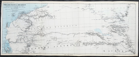
1877 Petermann Antique Map Expedition of Ernest Giles Western & South Australia in 1876
- Title : Thomas Elders Expedition durch Inner-Australien vom Murchison im Westen, bis zum Neales im Osten, Ausgefuhrt Durch E. Giles April-Aug 1876
- Size: 27in x 11in (285mm x 280mm)
- Condition: (A+) Fine Condition
- Date : 1877
- Ref #: 82056
Description:
This early folding original antique lithograph map of central Western & South Australia - from Sharks Bay to border of South Australia and Alexandra Land (Northern Territory) just south of Ayers Rock, covering the 5th and final expedition of the explorer Ernest Giles in 1876 by Augustus Heinrich Petermann was engraved in 1877 - dated - and was published by Justus Perthes, Gotha Germany.
General Definitions:
Paper thickness and quality: - Heavy and stable
Paper color : - off white
Age of map color: - Original
Colors used: - Blue, red, yellow
General color appearance: - Authentic
Paper size: - 27in x 11in (285mm x 280mm)
Plate size: - 27in x 11in (285mm x 280mm)
Margins: - Min 1/2in (12mm)
Imperfections:
Margins: - None
Plate area: - Folds as issued
Verso: - None
Background:
William Ernest Powell Giles 1835 – 1897 best known as Ernest Giles, was an Australian explorer who led five major expeditions in central Australia.
Giles did not attempt an organised expedition until 1872, when with two other men he left Chambers Pillar, South Australia (now in the Northern Territory), on 22 August and traversed much previously untrodden country to the north-west and west. Finding their way barred by Lake Amadeus and that their horses were getting very weak, a return was made to the Finke River and then to Charlotte Waters and Adelaide, where Giles arrived in January 1873. Giles looked upon his expedition as a failure, but he had done well considering the size and equipment of his party.
Giles friend Baron von Mueller raised a subscription so that a new expedition could be made. The services of William Tietkens as first assistant were obtained, and with two other men a start was made on 4 August 1873. The journey began considerably south from the previous expedition and from the Alberga River a generally western course was traversed. A month later in the Musgrave Ranges a fine running river was found and named the Ferdinand and by 3 October 1873 the party was approaching longitude 128 East. The country was extremely dry and though tested in various directions it was a constant struggle to get enough water to keep the horses going. Early in November, having passed longitude 126, a partial return was made and on 20 December 1873 the neighbourhood of Mount Scott was reached. A turn to the north and then west was made and the farthest westerly point was reached on 23 April 1874. Giles and one of the men, Alfred Gibson, had been scouting ahead when the latter\'s horse died. Giles gave him his own horse with instructions to follow their tracks back and obtain assistance. Giles made his way back to their depot on foot in eight days, almost completely exhausted, to find that Gibson had not reached the camp. A search was made for him for several days without success. The stores were almost finished, nothing further could be done, and on 21 May 1874 the return journey began. Giles named the desert Gibson Desert after his companion. On 24 June 1874 they were on a good track to the Finke River and on 13 July 1874 Charlotte Waters was reached. Giles had again failed to cross the continent, but in the circumstances all had been done that was possible.
Giles was the first European to see the rock formations of The Olgas, now known by their Aboriginal name of Kata Tjuta, and Lake Amadeus. He had wanted to name these Mt Mueller and Lake Ferdinand respectively, to honour his benefactor Baron Ferdinand von Mueller, however Mueller prevailed on him to instead honour the King Amadeus of Spain and Queen Olga of Württemberg. Giles supposedly discovered Uluru (formerly Ayers Rock), but was beaten to the claim by a competing explorer, William Gosse.
Early in 1875 Giles prepared his diaries for publication under the title Geographic Travels in Central Australia, and on 13 March 1875, with the generous help of Sir Thomas Elder, he began his third expedition. Proceeding considerably to the north from Fowler\'s Bay the country was found to be very dry. Retracing his steps Giles turned east, and eventually going round the north side of Lake Torrens reached Elder\'s station at Beltana. There the preparations for his fourth journey were made, and with Tietkens again his lieutenant, and with what Giles had always wanted, a caravan of camels, a start was made on 6 May. Port Augusta was reached on 23 May and, after taking a northerly course to clear the lakes, a generally westerly course was followed. Some water was carried, and the party was saved the continual excursions in search of water for horses that had caused so much difficulty during previous expeditions. Towards the end of September over 323 miles (520 km) had been covered in 17 days without finding water, when on 25 September the native Tommy found an abundant supply in a small hollow between sand dunes at Queen Victoria Spring, and the party was saved. After a rest of nine days the journey was resumed on 6 October the course being still west. Ten days later the expedition was attacked by a large body of aborigines and Giles was compelled to fire on them. On 4 November they met a white stockman at Tootra out-camp, east of Bindi Bindi. Their course was west to Walebing Station, then south-west and on 11 November they arrived at New Norcia where they were welcomed by Bishop Salvado. On 17 November 1875 the party arrived at Guildford and Perth the next day, where they received an enthusiastic reception.
Giles stayed for two months at Perth. Tietkens and Jess Young, another member of the expedition, went back to Adelaide by sea, and on 13 January 1876 Giles began the return journey taking a course generally about 400 miles north of the last journey. He arrived at Adelaide in September 1876 after a good journey during which the camels were found to be invaluable.
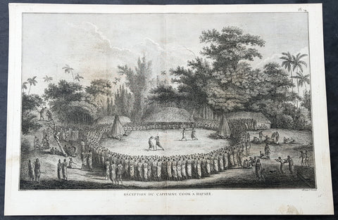
1785 Capt Cook Antique Print Cook Reception on Lifuka Island, Haapai Tonga, 1777
- Title : Reception Du Capitaine Cook a Hapaee (Reception for Captain Cook in Hapaee)
- Size: 15 1/2in x 10 1/2in (395mm x 265mm)
- Ref #: 21437
- Date : 1785
- Condition: (A+) Fine Condition
Description:
This fine original copper-plate engraved antique print of the reception for Captain Cook on the island of Lifuka, one of the islands of the Haapai group of Tonga Islands, visited by Captain Cook in 1777, during his 3rd & last Voyage of Discovery, was engraved by Robert Benard - after John Webber - and was published in the 1785 French edition of Capt. James Cook & Capt. James King publication A Voyage to the Pacific Ocean. Undertaken, by the Command of his Majesty, for making Discoveries in the Northern Hemisphere. To determine The Position and Extent of the West Side of North America; its Distance from Asia; and the Practicability of a Northern Passage to Europe. Performed under the direction of Captains Cook, Clerke, and Gore, In His Majestys Ships the Resolution and Discovery. In the Years 1776, 1777, 1778, 1779, and 1780. In Three Volumes. Vol. I and II written by James Cook, F.R.S. Vol. III by Captain James King, LL.D. and F.R.S. Paris, 1785.
Captain Cook seated with the chiefs, watching two pairs of combatants, one pair boxing, the other pair fighting with clubs within a large circle of spectators. Some men of Cook\'s company are on the left on the fringe of the crowd.
............presently after a number of men entered the Circle or Area before us, armed with Clubs made of the green branches of the Cocoanut tree, these paraded about for a few minutes and then retired the one half to one side and the other half to the other, and seated themselves before the spectators: but soon after went to single Combat, one or two steping forward from the one side and chalenging those on the other which was done more by actions than words; if the Challenge was expected, which was generally the case, each put himself in a proper attitude and began to engage and continued till one or the other gave out or their weapons were broke….there were Wristling and Boxing matches; the first were performed in the same m[an]ner as at Otahiete, and the second very little different from the method practiced in England. Cook Journals III, i, 107
General Definitions:
Paper thickness and quality: - Heavy and stable
Paper color : - off white
Age of map color: -
Colors used: -
General color appearance: -
Paper size: - 15 1/2in x 10 1/2in (395mm x 265mm)
Plate size: - 14 1/2in x 9 1/2in (370mm x 245mm)
Margins: - Min 1/2in (12mm)
Imperfections:
Margins: - Light soiling
Plate area: - None
Verso: - Light soiling
Background:
Lifuka is an island in the Kingdom of Tonga. It is located within the Haapai Group in the centre of the country, to northeast of the national capital of Nukualofa.
Lifuka is the place where Captain James Cook dubbed Tonga The Friendly Islands. Tofua is where the mutiny on the Bounty occurred in 1789; this active volcanic island lies approximately forty nautical miles west of Lifuka. The Cpt. Bligh voyage stands as the longest successful passage ever recorded in an open boat without modern navigational aids.
Haapai is a group of islands, islets, reefs and shoals with an area of 109.30 square kilometres in the central part of the Kingdom of Tonga, with the Tongatapu group to the south and the Vavau group to the north. Seventeen of the Ha apai islands are populated with altogether 6,616 people.
The first European to visit Ha apai, was Abel Tasman in 1643. Captain James Cook in 1774 and 1777, made several stops on the islands. He gave them the name of Friendly Islands in 1777.
On 18 May 1777, Cook arrived with Omai. They were greeted by Fatafehi Paulaho, King of the Isles or Tui Tonga, the most sacred chief in these islands.
Tonga officially the Kingdom of Tonga, is a Polynesian sovereign state and archipelago comprising 169 islands, of which 36 are inhabited. The total surface area is about 750 square kilometres (290 sq mi) scattered over 700,000 square kilometres (270,000 sq mi) of the southern Pacific Ocean. It has a population of 107,122 people, of whom 70% reside on the main island of Tongatapu.
The Tongan people first encountered Europeans in 1616 when the Dutch vessel Eendracht, captained by Willem Schouten, made a short visit to trade. Later came other Dutch explorers, including Jacob Le Maire (who called on the northern island of Niuatoputapu); and in 1643 Abel Tasman (who visited Tongatapu and Haapai).
Later noteworthy European visitors included James Cook (Royal Navy) in 1773, 1774, and 1777; Alessandro Malaspina (Spanish Navy) in 1793; the first London missionaries in 1797; and the Wesleyan Methodist Reverend Walter Lawry in 1822.
Tonga became known in the West as the Friendly Islands because of the congenial reception accorded to Captain James Cook on his first visit in 1773. He arrived at the time of the inasi festival, the yearly donation of the First Fruits to the Tui Tonga (the islands paramount chief) and so received an invitation to the festivities. According to the writer William Mariner, the chiefs wanted to kill Cook during the gathering but could not agree on a plan.
Captain James King FRS 1750 – 1784 was an officer of the Royal Navy. He served under James Cook on his last voyage around the world, specialising in taking important astronomical readings using a sextant. After Cook died he helped lead the ships on the remainder of their course, also completing Cooks account of the voyage. He continued his career in the Navy, reaching the rank of post-captain, commanding several ships and serving in the American War of Independence.
King joined HMS Resolution as second lieutenant, sharing the duties of astronomer with Cook, taking astronomical observations on board by sextant and with Larcum Kendals timekeeper K1, to establish the Resolutions position at sea and on shore by sextant or by astronomical quadrant to establish the geographical position of salient points during the course of Cooks surveys. Thus Kings geographical positions were an important contribution to the accuracy of the various surveys carried out during the voyage and his use of the early chronometers helped prove their use at sea for calculation of Longitude. .
Following the death of Cook, King remained in the Resolution but on the death of Charles Clerke, Cooks successor, King was appointed to command HMS Discovery, the Resolutions consort, remaining in her for the rest of the voyage. After his return to England King was very much involved in the publication of the official account of Cooks third voyage, writing the third volume at Woodstock, near Oxford, where his brother Thomas was rector of St Mary Magdalene. But shortly after his return King was promoted Post-captain and appointed commander of HMS Crocodile in the English Channel.
John Webber RA 1751 – 1793 was an English artist who accompanied Captain Cook on his third Pacific expedition. He is best known for his images of Australasia, Hawaii and Alaska.
Webber was born in London, educated in Bern and studied painting at Paris.His father was Abraham Wäber, a Swiss sculptor who had moved to London, and changed his name to Webber before marrying a Mrs Mary Quant in 1744.
Webber served as official artist on James Cooks third voyage of discovery around the Pacific (1776–80) aboard HMS Resolution. At Adventure Bay in January 1777 he did drawings of A Man of Van Diemens Land and A Woman of Van Diemens Land. He also did many drawings of scenes in New Zealand and the South Sea islands. On this voyage, during which Cook lost his life in a fight in Hawaii, Webber became the first European artist to make contact with Hawaii, then called the Sandwich Islands. He made numerous watercolor landscapes of the islands of Kauai and Hawaii, and also portrayed many of the Hawaiian people.
In April 1778, Captain Cooks ships Resolution and Discovery anchored at Ship Cove, now known as Nootka Sound, Vancouver Island, Canada to refit. The crew took observations and recorded encounters with the local people. Webber made watercolour landscapes including Resolution and Discovery in Ship Cove, 1778. His drawings and paintings were engraved for British Admiraltys account of the expedition, which was published in 1784.
Back in England in 1780 Webber exhibited around 50 works at Royal Academy exhibitions between 1784 and 1792, and was elected an associate of the Royal Academy in 1785 and R.A. in 1791. Most of his work were landscapes. Sometimes figures were included as in A Party from H.M.S. Resolution shooting sea horses, which was shown at the academy in 1784, and his The Death of Captain Cook became well known through an engraving of it. Another version of this picture is in the William Dixson gallery at Sydney
Robert Bénard 1734 – 1777 was an 18th-century French engraver.
Specialized in the technique of engraving, Robert Ménard is mainly famous for having supplied a significant amount of plates (at least 1,800) to the Encyclopédie by Diderot & d Alembert from 1751.
Later, publisher Charles-Joseph Panckoucke reused many of his productions to illustrate the works of his catalog.
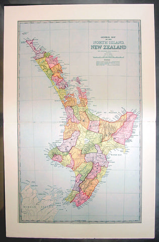
1888 Pic Atlas Large Antique Map of the North Island of New Zealand
- Title : General Map of The North Island of New Zealand
- Ref #: 50321
- Size: 28in x 18in (710mm x 460mm)
- Date : 1888
- Condition: (A+) Fine Condition
Description:
This large original antique map of the North Island of New Zealand was engraved in 1888 - the date is engraved at the foot of the map - by Alex J Scally and was published in the extremely significant Australian & New Zealand publicationThe Picturesque Atlas of Australasia between 1886-88. Also includes an index to the map on the verso giving names and locations of places on the map.
These maps were some of the best maps published at the time in the "Modern" look. The colour is bright, the engraving extremely fine and the paper heavy and stable.
The Picturesque Atlas of Australasia was published in Sydney between 1886-88. Many of its over 700 wood-engraved illustrations were specially commissioned works by leading Australian artists.
It was released in 42 separate editions usually bound into three large volumes and sold a remarkable 50,000 copies.
Its publication was one of the most significant cultural projects in nineteenth-century Australia. Writers, artists, academics and politicians came together to prepare a book of unprecedented grandeur and ambition, and a publishing company was established to produce and publish it. The seven hundred engravings on steel and wood contained in the Picturesque Atlas were among the finest engravings to be found anywhere in the world at this time.
The Atlas was a collegial project, staffed by a large number of artists and garnering an unusual number of contributors for one work. Lightly supervised by the former Sydney Morning Herald editor Andrew Garran it was lavishly produced at the Wynyard Square headquarters of the Atlas company. It had the services of the Melburnian journalist and public figure James Smith who wrote much of the Victorian and Tasmanian material, and W.H. Traill wrote extensively about Queensland. It was not, of course, an Atlas is the usual sense of the word, maps playing a comparatively minor role. But use of Atlas in the title, Hughes-d'Aeth notes, gave a sense of the scale of the publication both in terms of comprehensiveness and format. As the author points out, calling it an Atlas carries a promise of the exactitude of the relationship between the subject and its representation, and also bears a sense of the acquisitiveness that shadows the imperial phase of cartography.
There were only thirty maps in the Atlas's 800 pages, but there were hundreds of pictures. This is where much of the ideological work of the Atlas was completed and this is where Paper Nation concentrates its analysis. Its first task is to unravel the linguistic ball of string that is the word 'picturesque'. Though Humphrey Repton and Uvedale Price had their opinions, Hughes-d'Aeth is quite right to pick William Gilpin out of the line-up of suspicious aesthetes, for it was he who really popularised the idea of travelling in search of picturesque views. Paper Nation's dissection of the term picturesque is particularly aware of the term's adaptation to colonial usage, and its mutations through time. The picturesque took on an increasingly acquisitive edge, as admiration of the beauty of the land was joined by a concern to exploit it. A 'deep reverence for production' can be seen in the Picturesque Atlas's many illustrations of mines, factories and agricultural processes. The slag heaps of a mine were now as 'picturesque' as a fern-filled valley, but this does mean that the term was evacuated of all meaning. Rather the aesthetic appropriation of the land and its material exploitation were part of a continuum of colonial attitudes, and it was the duty of the Picturesque Atlas to affirm and re-affirm the rightness of European habitation and progress. (Ref: M&B; Tooley)
General Description:
Paper thickness and quality: - Light & stable
Paper color: - White
Age of map color: - Original
Colors used: - Pink, yellow, green, blue
General color appearance: - Authentic
Paper size: - 28in x 18in (710mm x 460mm)
Plate size: - 28in x 18in (710mm x 460mm)
Margins: - Min 1in (25mm)
Imperfections:
Margins: - None
Plate area: - None
Verso: - None
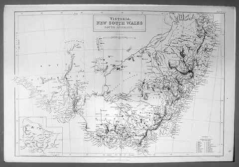
1844 Hughes Antique Australian Map of the States of Victoria & NSW
- Title : Victoria New South Wales and South Australia
- Ref #: 91204
- Size: 17in x 11 1/4in (430mm x 285mm)
- Date : 1844
- Condition: (A+) Fine Condition
Description:
This finely engraved original antique map of the Australian States of NSW, Vic & part of SA was engraved by William Hughes and published by A&C Black in 1844. (Ref: Tooley; M&B)
General Description:
Paper thickness and quality: - Light and stable
Paper color: - off white
Age of map color: -
Colors used: -
General color appearance: -
Paper size: - 17in x 11 1/4in (430mm x 285mm)
Plate size: - 17in x 11 1/4in (430mm x 285mm)
Margins: - Min 1/2in (12mm)
Imperfections:
Margins: - None
Plate area: - None
Verso: - None
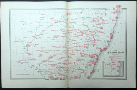
1886 Picturesque Atlas Large Antique Rainfall Map of New South Wales, Australia
- Title : Map of New South Wales showing Average Annual Rainfall
- Ref : 50340
- Size: 26in x 18in (660mm x 446mm)
- Date : 1886
- Condition: (A+) Fine Condition
Description:
This large fine lithograph layered coloured original map was published in the extremely significant Australian & New Zealand Australian & New Zealand publication The Picturesque Atlas of Australasia between 1886-88.
The Picturesque Atlas of Australasia was published in Sydney between 1886-88. Many of its over 700 wood-engraved illustrations were specially commissioned works by leading Australian artists. It was released in 42 separate editions usually bound into three large volumes and sold a remarkable 50,000 copies. (Ref: M&B; Tooley)
General Description:
Paper thickness and quality: - Light & stable
Paper color: - White
Age of map color: - Original
Colors used: - Blue, yellow, pink, green
General color appearance: - Authentic
Paper size: - 26in x 18in (660mm x 446mm)
Margins: - Min 1in (25mm)
Imperfections:
Margins: - None
Plate area: - None
Verso: - None