Atlases (4)

1774 Cook & Hawkesworth Antique Atlas of Australia, New Zealand 52 Maps & Prints
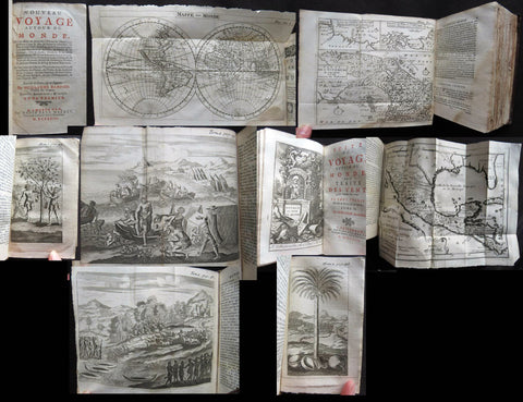
- Title : Cartes et figures des voyages entrepris par ordre de sa Majesté Britannique, actuellement régnante ; pour faire des découvertes dans l'hémisphère méridional, et successivement exécutés par le Commodore Byron, le Capitaine Carteret, le Capitaine Wallis & le Capitaine Cook dans les vaisseaux. MDCCLXXIV (1774)
- Size: 4to (Quatro)
- Condition: (A) Very Good Condition
- Date : 1774
- Ref #: 35632
Description:
This original antique Atlas containing 52 maps and prints, as called for, from some of the foremost explorers of the mid 18th century, including Commodore Byron, Captain Carteret, Captain Wallis & Captain James Cook, was published as the 1st French edition of Cartes et figures des voyages entrepris par ordre de sa Majesté Britannique: (Maps and Figures of Travels undertaken by Order of his Present Reigning British Majesty) in 1774, published after only a year after the 1st English edition by John Hawkesworth.
The 52 prints and maps contained in this atlas chart in maps, prints and plans, the progression in the exploration of the South Seas of the 4 explorers. But there is of course, the standout amongst these 4 explorers and that is of course Captain James Cook.
At the time of the publication of this tome, Cook had returned from his first voyage of exploration to The South Pacific, becoming the first European to survey and chart the coastline of New Zealand and the east coast of Australia. But at this point Cook was not as famous as he was destined to become, after completing 2 more voyages of exploration, and in turn becoming the most famous explorer of his era.
The majority of this atlas contains the prints and maps dedicated to Cooks 1st Voyage of Discovery including the two famous maps, one of New Zealand and the other the East Coast of Australia. All voyages can be tracked from the first large folding map of the South Seas, at the beginning of the Atlas, that illustrates the tracks on Cook and the other 3 explorers.
In-4 binding in half-calf, spine with five bands with gilding boxes and title label complete with 52 folding & single plates
Spine & boards in poor condition with lack of leather and scratched covers, contents tights with plates in very good condition.
General Definitions:
Paper thickness and quality: - Heavy and stable
Paper color : - off white
Age of map color: -
Colors used: -
General color appearance: -
Paper size: - 4to (Quatro)
Plate size: - 4to (Quatro)
Margins: - 4to (Quatro)
Imperfections:
Margins: - Light age toning - Maps & Prints
Plate area: - Folds as issued - Maps & Prints
Verso: - Folds as issued - Maps & Prints
Background:
Capt. Cook First Voyage 1768 - 1771:
In 1768 Cook was chosen to lead an expedition to the South Seas to observe the Transit of Venus and to secretly search for the unknown Great Southern Continent (terra australis incognita).
Cook and his crew of nearly 100 men left Plymouth (August 1768) in the Endeavour and travelled via Madeira (September), Rio de Janiero (November-December) and Tierra del Fuego (January 1769) to Tahiti.
At Tierra del Fuego (January 1769) Cooks men went ashore and met the local people whom Cook thought perhaps as miserable a set of People as are this day upon Earth. Joseph Bankss party collected botanical specimens but his two servants, Thomas Richmond and George Dorlton, died of exposure in the snow and cold. Leaving Tierra del Fuego Endeavour rounded Cape Horn and sailed into the Pacific Ocean.
Sir Joseph Banks wrote about the homes of the Fuegans
..…huts or wigwams of the most unartificial construction imaginable, indeed no thing bearing the name of a hut could possibly be built with less trouble. They consisted of a few poles set up and meeting together at the top in a conical figure, these were covered on the weather side with a few boughs and a little grass, on the lee side about one eighth part of the circle was left open and against this opening was a fire made.......(Banks, Journal I, 224, 20th January 1769)
Samuel Wallis on the ship Dolphin discovered Tahiti in 1767. He recommended the island for the Transit of Venus observations and Cook arrived here in April 1769. Cook, like Wallis two years before him, anchored his ship in the shelter of Matavai Bay on the western side of the island.
In Matavai Bay Cook established a fortified base, Fort Venus, from which he was to complete his first task – the observation of the Transit of Venus (3rd June 1769). The fort also served as protection for all the important scientific and other equipment which had to be taken ashore as:
.......great and small chiefs and common men are firmly of opinion that if they can once get possession of an thing it immediately becomes their own…the chiefs employd in stealing what they could in the cabbin while their dependents took every thing that was loose about the ship…...(Joseph Banks).
Theft by some native peoples plagued Cooks voyages.
Cook and his crew experienced good relations with the Tahitians and returned to the islands on many occasions, attracted by the friendly people of this earthly paradise. On arrival Cook had set out the rules, including:
.....To endeavour by every fair means to cultivate a friendship with the Natives and to treat them with all imaginable humanity....
Just as Cook was planning to leave Tahiti two members of Endeavours crew decided to desert, having strongly attached themselves to two girls, but Cook recovered them.
Cook sailed around the neighbouring Society Islands and took on board the Tahitian priest, Tupaia, and his servant, Taiata. Endeavour left the Society Island in August 1769.
Tupaia acted as interpreter when they came into contact with other Polynesian peoples and helped Cook to make a map of the Pacific islands. This showed Cook the location of islands arranged according to their distance from Tahiti and indicated Tupaias and Polynesian knowledge of navigation and their skill as great mariners.
Cook sailed in search of the Southern Continent (August-October 1769) before turning west to New Zealand. The first encounters with the native Maori of New Zealand in October were violent, their warriors performing fierce dances, or hakas, in attempts to threaten and challenge the ships crew. Some of their warriors were killed when Cooks men had to defend themselves. Eventually relations improved and Cook was able to trade with the Maori for fresh supplies.
Exploring different bays and rivers along the way Cook circumnavigated New Zealand and was the first to accurately chart the whole of the coastline. He discovered that New Zealand consisted of two main islands, north (Te Ika a Maui) and south (Te Wai Pounamu) islands (October 1769-March 1770).
The artist Sydney Parkinson described three Maori who visited the Endeavour on 12th October 1769:
......Most of them had their hair tied up on the crown of their heads in a knot…Their faces were tataowed, or marked either all over, or on one side, in a very curious manner, some of them in fine spiral directions…
This Maori wears an ornamental comb, feathers in a top-knot, long pendants from his ears and a heitiki, or good luck amulet, around his neck.
At the northern end of the south island Cook anchored the ship in Ship Cove, Queen Charlotte Sound, which became a favourite stopping place on the following voyages. Parkinson noted:
......The manner in which the natives of this bay (Queen Charlotte Sound) catch their fish is as follows: - They have a cylindrical net, extended by several hoops at the bottom, and contracted at the top; within the net they stick some pieces of fish, then let it down from the side of the canoe and the fish, going in to feed, are caught with great ease.....(Parkinson, Journal, 114)
In Queen Charlottes Sound Cook visited one of the many Maori hippah, or fortified towns.
........The town was situated on a small rock divided from the main by a breach in a rock so small that a man might almost Jump over it; the sides were every where so steep as to render fortifications iven in their way almost totally useless, according there was nothing but a slight Palisade…in one part we observed a kind of wooden cross ornamented with feathers made exactly in the form of a crucifix cross…we were told that it was a monument to a dead man.......
Endeavour left New Zealand and sailed along the east coast of New Holland, or Australia, heading north (April-August 1770). Cook started to chart the east coast and on 29th April landed for the first time in what Cook called Stingray, later, Botany Bay.
The ship struck the Great Barrier Reef and was badly damaged (10 June). Repairs had to be carried out in Endeavour River. (June-August 1770). The first kangaroo to be sighted was recorded and shot.
The inhabitants of New Holland were very different from the people Cook had come across in other Pacific lands. They were darker skinned than the Maori and painted their bodies:
......They were all of them clean limnd, active and nimble. Cloaths they had none, not the least rag, those parts which nature willingly conceals being exposed to view compleatly uncovered......(Joseph Banks)
Tupaia could not make himself understood and at first the aborigines were very wary of the visitors and not at all interested in trading.
Joseph Banks recorded the fishing party observed at Botany Bay on 26 April 1770. He wrote:
......Their canoes… a piece of Bark tied together in Pleats at the ends and kept extended in the middle by small bows of wood was the whole embarkation, which carried one or two…people…paddling with paddles about 18 inches long, one of which they held in either hand.....(Banks, Journal II, 134)
Endeavour left Australia and sailed via the Possession Isle and Endeavour Strait for repairs at Batavia, Java (October-December 1770). Although the crew had been quite healthy and almost free from scurvy, the scourge of sailors, many caught dysentery and typhoid and over thirty died at Batavia or on the return journey home via Cape Town, South Africa (March-April 1771). The ship arrived off Kent, England (July 1771).
The voyage successfully recorded the Transit of Venus and largely discredited the belief in a Southern Continent. Cook charted the islands of New Zealand and the east coast of Australia and the scientists and artists made unique records of the peoples, flora and fauna of the different lands visited.
Vice-Admiral John Byron (1723-1786) was a British naval officer and explorer. He is known for his circumnavigation of the globe aboard the HMS Dolphin, completing one of the first British expeditions to achieve this feat. His account of the voyage, "The Narrative of the Honourable John Byron," influenced subsequent explorations. Byron's naval career included service in the Seven Years' War and the American Revolutionary War.
Rear-Admiral Philip Carteret (1733-1796) was a British naval officer and explorer. He is best known for his role as the captain of HMS Swallow during the first circumnavigation of the globe. Carteret's expedition, which took place from 1766 to 1769, aimed to explore and map uncharted regions of the Pacific Ocean. His discoveries included the Carteret Islands and the Pitcairn Islands. Carteret's voyage greatly contributed to the knowledge of Pacific geography and exploration during that time.
Samuel Wallis (1728-1795) was a British naval officer and explorer. He is renowned for leading the first recorded European expedition to visit Tahiti and for his significant contributions to the exploration of the Pacific Ocean. In 1766, Wallis commanded HMS Dolphin on a voyage funded by the British Admiralty. During the expedition, he discovered and named several islands, including Tahiti, which he encountered in June 1767. Wallis's visit to Tahiti marked the beginning of sustained European contact with the island and its inhabitants. His exploration efforts and subsequent reports greatly expanded European knowledge of the Pacific region. Wallis's achievements laid the foundation for future explorations and influenced subsequent voyages of exploration in the Pacific.
John Hawkesworth 1715 -1775
An English writer and journalist, Hawkesworth was commissioned by the British Admiralty to edit for publication the narratives of its officers circumnavigations. He was given full access to the journals of the commanders and the freedom to adapt and re-tell them in the first person. Cook was already on his way back from his second Pacific voyage, temporarily docked at Cape Town (South Africa), when he first saw the published volumes: he was mortified and furious to find that Hawkesworth claimed in the introduction that Cook had seen and blessed (with slight corrections) the resulting manuscript. (In his defense, Hawkesworth also had been a victim of misunderstanding.) Cook had trouble recognizing himself. Moreover, the work was full of errors and commentary introduced by Hawkesworth and, in Cooks view, too full of Banks, who had promoted himself and the publication. Still, the work was popular; the first edition sold out in several months.
Cook , Capt. James 1728-1779
James Cook was born on 27 October 1728 in Marton, England. His father was a poor farm labourer who had worked his way up to Overseer. James began as a farm labourer and grocer\\\'s assistant. He soon found employment on the Baltic sea in a Collier (coal transport ship) at the age of 18.
During the war with the French in 1755, James Cook enlisted as an Able Seaman on the Eagle. Within a month he was promoted, because of outstanding ability, to Masters Mate. Four years later he was promoted to Master. In command of his own ship, James Cook performed a crucial charting of the St. Lawrence River, which made possible the great amphibious assault upon Quebec City in 1759. In 1763 he was given command of the schooner Grenville to survey the eastern coasts of Canada over a four year period. These excellent charts were used up until the early part of the 20th century.
James Cook was selected to lead a 1768 expedition to observe the transit of Venus, and to explore new lands in the Pacific Ocean. In his first Pacific voyage, James Cook rounded Cape Horn in the Endeavour and reached Tahiti on 3 June 1769. After recovering a necessary scientific instrument stolen by the natives, the transit of Venus was successfully observed. The Endeavour then spent six months charting New Zealand. James Cook next explored and claimed possession of eastern Australia. Returning to England, on 12 June 1771, via New Guinea, Java and the Cape of Good Hope, the crew suffered an appalling 43% fatality rate. James Cook thus became very concerned about crew health on subsequent voyages. He instituted compulsory dietary reforms that were copied by many other ship captains.
The object of Captain Cook\\\'s second Pacific Ocean voyage was to confirm the existence of a theorized Great Southern Continent. His ship the Resolution, accompanied by the Adventure, departed Plymouth on 13 July 1772 and sailed around the Cape of Good Hope. Beset by ice, he was unable to reach Antarctica. Although its existence was suspected, James Cook demonstrated, by traversing large areas of the south Pacific, that it would have to be a frigid wasteland, and not an economically productive addition to the British empire. James Cook charted many of the South Pacific islands with the incredible accuracy of 3 miles. This accuracy was made possible by a new and highly accurate clock. The two ships returned to England, via Cape Horn, on 29 July 1775. The experimental diets and close attention to cleanliness had a miraculous effect: out of a crew of 118, only one man was lost to disease! Since public interest was high, the many paintings by the artists were widely displayed and published as engravings. James Cook was also awarded the Copley Gold Medal and elected as a fellow of the Royal Society.
The third great voyage is especially significant to the history of the west coast of North America. Captain Cook and his men were primarily searching for the Northwest Passage from the Pacific Ocean to the Atlantic Ocean. They departed Plymouth on 12 July 1776 in the Resolution and the Discovery.
The ships sailed around the Cape of Good Hope to reach the west coast of America in February of 1778. They continued north along the coast in haste to the Bering Sea and Bering Strait in an attempt to pass through the Arctic Ocean during the summer season. Foiled by ice, James Cook returned to Hawaii to prepare for another attempt at the Northwest Passage the next season. Soon after they had departed, a storm damaged the foremast of the Resolution and forced a return to Kealakekua Bay for repairs. Unfortunately, they had previously overstayed their welcome and relations became tense. The theft of a ship\\\'s cutter led Captain Cook to put ashore to demand the return of the boat. A fight broke out and James Cook was killed on 14 Feb 1779 by angry natives. Although his men made another attempt at the Northwest Passage, they were unsuccessful. The expedition did identify the possibilities of trade with the coastal American natives for otter seal furs, which could then be bartered for Chinese goods that were highly prized in England.
1723 William Dampier 2 Volumes of World Voyages to America Australia Asia - 20 x Maps & Plates
- Title : Nouveau Voyage Autour Du Monde...Ou l on decrite en particular l Isthme de l Amerique, plusieurs côtes et isles des Indes Occidentales...1723
- Size: 8vo
- Condition: (A) Very Good Condition
- Date : 1723
- Ref #: 93005
Description:
These two beautiful leather bound volumes of William Dampiers voyages to America, New Holland (Australia) and the East Indies, contains 5 titles with 20 maps & plates (some folding) and was published in Amsterdam by David Paul Marret in 1723 (dated)
These 2 volumes are the French translation of the voyages of the English explorer, ex-pirate and navigator, William Dampier, who became the first Englishman to explore parts of what is today Australia, and the first person to circumnavigate the world three times between 1679 & 1711. He has also been described as Australia\'s first natural historian, as well as one of the most important British explorers of the period between Sir Walter Raleigh and James Cook.
After impressing the British Admiralty with his book, A New Voyage Round the World, Dampier was given command of a Royal Navy ship and made important discoveries in western Australia, but was court-martialled for cruelty. On a later voyage, he rescued Alexander Selkirk, a former crew mate who may have inspired Daniel Defoe\'s Robinson Crusoe. Others influenced by Dampier include James Cook, Lord Nelson, Charles Darwin and Alfred Russel Wallace.
General Definitions:
Paper thickness and quality: - Heavy and stable
Paper color : - off white
Age of map color: -
Colors used: -
General color appearance: -
Paper size: - 8vo
Plate size: - 8vo
Margins: - Min 1/2in (12mm)
Imperfections:
Margins: - Please see below for condition report
Plate area: - Please see below for condition report
Verso: - Please see below for condition report
Background:
The two volumes contain the following 5 titles with 20 maps & plates.
Volume 1.
1. Nouveau Voyage Autour Du Monde...Ou l\'on decrite en particular l\'Isthme de l\'Amerique, plusieurs côtes et isles des Indes Occidentales, les Isles du Cap Verd, le passage par la Terre del Fuego, les côtes meridionales du Chili, du Perou & du Mexique; l\'Isle de Guam, Mindanao, & des autres Philippines, les isles orientales qui sont prés de Cambodie; de la Chine; Formosa; Luçon, Celebes, &c., la Nouvelle Hollande, les Isles de Sumatra, de Nicobar & de Sainte Helene & le Cap de Bonne Esperance...Ou l\'on traite des differens terroirs de tous ces pays, de leurs ports, des plantes, des fruits & des animaux qu\'on y trouve; de leurs habitans, de leurs coûtumes, de leur religion, de leur gouvernement, de leur negoce, &c....1723
This volume refers to Dampiers voyages to North & South America, East Indies, SE Asia, China, Australia & Africa.
Contains Title page, 8 maps & plates total of 340 pages.
a) Mappe-Monde - World map with Dampiers tracks.
b) Maps of the Isthmus of Panama and Central America
c) Print of Natives gathering fruit
d) Print of Dampier loading Gold from the New World
e) Voyage au tour du Monde title page
f) Map of Mexico & southern North America
g) Print of a battle in the East indies
h) Print of a coconut palm in East Indies
2. Suite du Voyage Autour du Monde... Avec un Traite Des Vents qui regnent dans toute..LA ZONE TORRIDE Enrichi de Cartes & de Figures..1723
This volume refers to the contuinuation of Dampiers voyages to North & South America, East Indies, SE Asia, China, Australia & Africa along with a description of global winds and tides.
Contains title page along with 6 maps & plates, 227 pages.
a) Engraved Voyage au Tour Du Monde
b) Print of ships offshore from the city of Manila in the Phillippines
c) View of Manila
d) 2nd print of ships offshore from the city of Manila in the Phillippines
e) Map of the Philippines islands of Banshee
f) Map of Pulocondor, Malayia
g) Print of Dampiers ship and compass rose
3. Traits des Vents Aliisez ou Reglez des Vents Frais ...1715
This volume refers again to globle winds & tides.
Contains title page 2 maps & 148 pages
a) Description of winds and tides in the eastern hemisphere
b) Description of winds and tides in the eastern hemisphere
Volume 2.
1. Voyage Autour Du Monde... Contenant une Description d\'Achin,
Ville de Sumatra, du Royaume de Tonquin & autres Places des Indes,
& de la Baye de Campeche. Ou l\'on traite des differens terroirs de tous ces pays, de leurs ports, des plantes, des fruits & des animaux qu\'on y trouve; de leurs
habitans, de leurs coûtumes, de leur religion, de leur gouvernement,
de leur negoce, &c...1723
This volume refers to the continuation of Dampiers travels in East Indies, SE Asia & Mexico
Contains title page, 4 maps & plates, 264 pages.
a) Royalty in Vietnam
b) Map of central & north America
b) Print of Vietnam
c) Map of Australia & East Indies
2. Voyages de Guillaume Dampier a la Baye de Campeche...1714
This volume refers to Dampiers travel to Campeche, Mexico.
Contains title page and 197 pages.
Condition Report: Two volumes bound in full leather with five raised bands to spines, and title label. Couple of minor chips to top of both spines. The leather is scuffed and little pitted/worn (see photos). Internally there are a couple of small chips to inner edges of front and rear end-papers. Inscription to front end-papers (Gift of W. Wood 1745) and bookplate to inside front board (Lord Sandys). The title page of volume III and following four or so leaves have damp staining, and there is light damp staining throughout Volume I & II. The damp staining has caused the leaves to become softer and little chipped, with some nicks/tears and chips. There is a tear/crease to top inner edge and chip to bottom corner of title page of volume I. Scattered pale foxing/browning. Several of the plates have occasional creases. Four leaves of volume III are gently detaching and two leaves of volume I are missing. A few leaves are a little faded. Overall VG, in readable with firm binding.
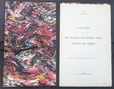
1874 Colonial Govt. Text & Maps on Boundary between South Australia & Victoria
- Title : 1874 Victoria - Papers relating to The Boundary Line Between South Australia and victoria - presented to both houses of parliament by his excellencys Command...John Ferres, Gov. Printer, Melbourne
- Ref #: 91463
- Size: 4to
- Date : 1874
- Condition: (A+) Fine Condition
Description:
This very scarce original Australian Government report prepared for both houses of Parliament over the boundary between the states of South Australia and Victoria was presented in 1874. The bound submission contains 28 pages of parliamentary conversations, reports and tables relating to the conflict over the boundary and two photo lithograph maps one of the Lower part of the Glenelg River showing the old and new proposed boundary lines and the 2nd map shows the original boundary line between NSW and South Australia and the subsequent Victorian boundary line.
This is an amazingly rare document (I have never seen one outside of the state or federal libraries) giving us a snapshot into a controversial period in the history of the two states.
Bound in 4to (14in x 9in) hard boards with ties, clean paper (some joined at top of page) in fine condition.
Background:
The border between the Australian state of South Australia and what is today the State of Victoria was established in 1836 by imperial letters patent "as the 141st degree meridian of longitude east of Greenwich". In 1836 the land we now call Victoria was part of the colony of New South Wales, so the original Victorian border was actually drawn between the colonies of South Australia and New South Wales. Due to human error by numerous explorers and surveyors, it took more than 75 years and a protracted legal dispute before the precise placement of the border was settled, resulting in the forfeiture of more than 1,300 km2 (500 sq mi) of territory from South Australia to Victoria.
Following the establishment of the colony of South Australia in 1835, the region between the coast and the Murray River was rapidly being settled by squatters selecting large runs for sheep grazing. With no clear border legal oversight was impossible. An accurate border needed to be defined. The earliest relevant reference to the eastern boundary of South Australia is contained in a despatch dated 30 September 1844 from Governor Grey of that Colony to Lord Stanley. The Governor reminded the Secretary of State that it would be extremely difficult to determine with accuracy a number of points upon the earth's surface through which the 141st degree of East longitude passes, and pointed out that in addition to difficulty there would be attendant expense both in ascertainment and maintenance.
In 1839 Charles Tyers was transferred from the Royal Navy to the Colonial Service and instructed by Sir George Gipps, the Governor of New South Wales, to ascertain the precise longitude at the mouth of the Glenelg River so that a distance to the 141st meridian (the eastern border of South Australia) could be measured.
Several months later Tyers completed a survey from Melbourne to the Glenelg River and on an expanse of sandy beach he formed a broad arrow with limestone rocks. This became known as Tyers' Mark and was used to determine the starting point for the border survey. Due to primarily inadequate equipment this was later determined to be 2 miles and 4 chains (3.3 km) in error.
For several years following Tyers' survey no action was taken to extend his work but by 1845 the need to have the boundary line defined on the ground had become urgent, particularly to the east of Mount Gambier. South Australian pastoralists had worked their way east from the coast and there were disputes when they met pastoralists from the Wimmera country pushing their way westwards with flocks of sheep.
There was uncertainty as to which Government should grant pastoral licenses to the squatters and which had legal control. In November 1846 the Colonial Secretary's Office directed surveyor Henry Wade to proceed from Sydney to the disputed territory to define a "Boundary for Police Purposes".
By March 1847 Wade had got his party of seven and equipment at the mouth of the Glenelg River. He was joined by assistant surveyor Edward White who had been appointed by the South Australian government to act as an observer on its behalf.
After much deprivation and hardship due to drought and reluctance by his men to continue with poor work conditions, Wade was still 155 miles (250 km) from the Murray River after nine months of swamp, sand dunes and broken equipment. The expedition collapsed at the 36th parallel of latitude. On 16 December 1847 the South Australian Government published a proclamation that the "line as marked on the ground" by Wade should be "deemed and construed" to be the eastern boundary of South Australia. In March, 1849 New South Wales issued a proclamation in similar terms. Wade later died in 1854.
As the survey was only partially completed the two colonies were in agreement that surveyor White should complete Wade's line to the Murray River as soon as possible. This was doubly urgent as the colony of Victoria was to be proclaimed within twelve months further complicating legal and later political matters.
In August 1849 the extension from Wade's line was begun. White and his party of five were similarly troubled by the severe nature of the Big Desert mallee country: where there was little water in 1847 there was none two years later. Within two weeks mutinous men had deserted him and two of his three horses collapsed from being without water for four days. White led the other until it also lay down, he himself was also on the verge of collapse but he managed to bleed the horse and drink half a pint of the blood. Lost, he did not know how far from the Murray River he was but he managed to stagger on for about two miles (3.2 km) to find himself on the riverbank at the border of three states and the survey completed. After drinking and resting he retreated back to the dead horses and collecting his saddle and bridle he returned to the river, managed to cross it and borrow a horse at Chowilla sheep station. He rode 180 miles (290 km) to Adelaide and filed a report on the survey. White died three years later.
Doubts as to the accuracy of the Wade-White line grew with the availability of better astronomical equipment and the advent of the telegraph. As a result of appointments of Government Astronomers in Sydney and Melbourne there were far more precise values for the longitudes of these places and hence the 141st longitude of the legal border.
By agreement an expedition left Adelaide in April 1868 for Chowilla near the Murray River and the border. It was led by George Smalley, N.S.W. Government Astronomer and Charles Todd South Australian Superindentent of Telegraphs. The purpose was to make transit observations of eleven stars whilst similar observations were made in Melbourne and Sydney. Whilst Tyers had used a small three inch (76 mm) theodolite this expedition had a 45-inch (1,100 mm) telescope, the largest available portable device in Australia at the time.
As a result of their observations Smalley and Todd declared the new 141st meridian. This led to the discovery that the proclaimed border on the ground was at least two miles and 19 chains (3.6 km) to the west of the more accurate measurement of the 141st meridian. The "Disputed Territory" as it was termed between the surveyed border and the actual 141st meridian contained over 500 square miles (1295 km²) of land. By 1849, 47% of it had already been sold freehold or leased out by the Victorian Government. If the more accurate border were adopted, Victoria would not have owned the land to be able to sell or lease it. This was the beginning of the battle of the Disputed Territory, a bone of contention which was to last for more than forty years.
The South Australian Government did not let the matter rest. In 1874 it suggested the value of the land was about £800,000. Between 1883 and 1893 South Australia sent more than 70 letters or telegrams to Melbourne seeking Victorian relinquishment or financial redress. There were many futile conferences. The nearest to an agreement between the two states was in 1908. Then it was decided, subject to ratification by Parliament, that £215,000 should be regarded as compensation to South Australia. Parliament did not ratify the proposal, nor did anything come of the 1909 South Australian premier's plan to send surveyors to subdivide some of the land on the east of White's marked border, the last "legally proclaimed" border.
South Australia finally abandoned all hope of settlement, due to Victoria's intransigence, and in 1911 it appealed to the High Court only to have the appeal dismissed. In 1914, it resorted to an appeal to the Judicial Committee of the Privy Council which unanimously ruled in favour of Victoria. (Ref Tooley M&B)
General Description:
Paper thickness and quality: - Heavy and stable
Paper color: - White
Age of map color: -
Colors used: -
General color appearance: -
Map #1 size: - 13 1/2in x 11in (345mm x 280mm)
Map #2 size: - 14in x 13 1/2in (355mm x 345mm)
Margins: - Min 1/2in (12mm)
Imperfections:
Margins: - None
Plate area: - None
Verso: - None
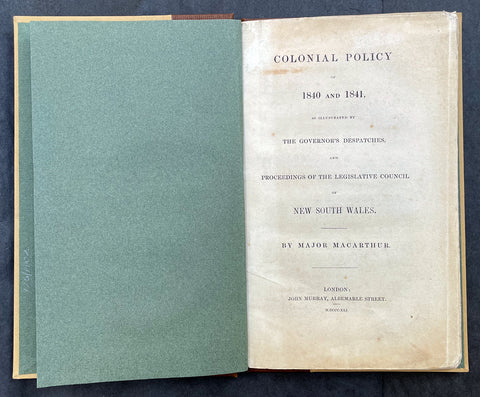
1841 Macarthur Antique Octavo Book on Colonial Policy in Australia, Map of NSW
- Title : Colonial Policy of 1840 and 1841, as illustrated by the Governor's Despatches, and Proceedings of the Legislative Council of New South Wales. By Major Macarthur.
- Ref #: 17045
- Size: Octavo
- Date : 1841
- Condition: (A+) Fine Condition
Description:
Fine original antique Octavo book with 79 pages and a single lithographed hand coloured map of eastern Australia & Van Diemens Land; uncut copy in half calf with gilt lettering by Edward Macarthur, advocating for immigration and trade for the colony of Australia, published by John Murray, London in 1841, dated.
This is the first of two books by Sir Edward Macarthurs advocating immigration to the colony of Australia. The eldest son of John and Elizabeth, Edward Macarthur was born at Bath in 1789, and accompanied his parents to New South Wales in 1790. As one of the first free settlers in the colony, he was a strong advocate of immigration, and served as Thomas Macqueens agent in arranging the first shipment of free immigrants in 1824, which gave great stimulus to agriculture.
The map illustrates a division of New South Wales and the subsequent creation of a smaller colony. Titled Eastern Australia or Territory of New South Wales, the map is captioned 'territory to which the Colony might be reduced by Bill of the last session' with reference debate in the House of Commons knocked down by Sir Robert Peel.
General Definitions:
Paper thickness and quality: - Heavy and stable
Paper color : - off white
Age of map color: - Original
Colors used: - Yellow
General color appearance: - Authentic
Paper size: - Octavo
Plate size: - Octavo
Margins: - Octavo
Imperfections:
Margins: - None
Plate area: - None
Verso: - None
Background:
Sir Edward Macarthur (1789-1872), soldier, was born on 16 March 1789 at Bath, England, the eldest son of Captain John Macarthur and his wife Elizabeth. He went to Sydney with his parents in 1790 and spent his boyhood there and at Elizabeth Farm, Parramatta. Sent to England in 1799 to be educated he returned to Sydney in 1806. With his father he took part in the deposition of Governor William Bligh in 1808. He soon left for London taking his father's version of the rebellion and the first bale of merino wool to be exported from the colony. He obtained a commission in the 60th Regiment and served at Corunna and in Sicily. As a lieutenant in the 39th Regiment he took part in Wellington's campaigns of 1812-14 and was present at Vittoria, the Pyrénées and the battles in southern France. After brief service in Canada he joined the army of occupation in France.
In 1824 Macarthur went to New South Wales as the agent of T. P. Macqueen. He was impressed by the dispersion of the garrison from Moreton Bay to Hobart Town in the face of runaway convicts and 'hostile tribes'. In London he placed detailed proposals for a colonial militia before Under-Secretary Horton but the plan was rejected by Governor (Sir) Ralph Darling in 1827. Macarthur competently represented Australian interests in London. He presented a petition from New South Wales in 1840. He advocated emigration in two small books, Colonial Policy of 1840 and 1841, as Illustrated by the Governor's Despatches, and the Proceedings of the Legislative Council of New South Wales (London, 1841) and Brief Remarks on Colonization (London, 1846). He personally arranged the migration of German vinedressers to the Macarthur properties at Camden and also sought to develop coastal steamship services. After serving as secretary in the Lord Chamberlain's Office in 1843-46 he was on the military staff in Ireland. In 1851 he was posted to Sydney as deputy adjutant general. Promoted colonel in 1854, he moved with the headquarters to Melbourne. He accompanied the commander-in-chief, Major-General Sir Robert Nickle, to Eureka on 5 December. They talked freely with the miners and as a result of their investigations Nickle advised that martial law be withdrawn.
After Nickle died in May 1855 and Governor Hotham in December, Macarthur took over command of the forces and became administrator. He inherited a confused political situation and was coolly received by the press. However, his impartiality and his willingness to leave things to his ministers helped him, and when he handed over to Sir Henry Barkly on 23 December 1856 he had won the esteem of parliament and the people of Melbourne. Emily, wife of Hugh Childers, described him as 'if not a brilliant statesman, an industrious, kind-hearted, Christian gentleman'. In 1858 Macarthur chaired a royal commission on the defences of the colony. In 1860 he returned to England and was appointed K.C.B. in 1862. In that year he married Sarah (d.1889), daughter of Lieutenant-Colonel W. S. Neill. Promoted lieutenant-general in 1866, he died childless in London on 4 January 1872 and was buried in the Brompton cemetery. He was survived by his wife. His goods were valued for probate at £4000.
Macarthur, Edward (1789 - 1872)
Macarthur was a lieutenant-general in the British Army, Commander-in-chief of British forces in Australia from 1855, and an administrator of the Colony of Victoria for 12 months, following the death of the Governor, Sir Charles Hotham.
Macarthur was the eldest son of John Macarthur, and his wife Elizabeth (née Veal). He was born at Bath, Somerset, England, and arrived at Sydney with his parents in the ships Neptune and Scarborough in 1790, part of the Second Fleet. Edward Macarthur is believed to be the only passenger on those ships of whom a photograph exists, although taken later in life. In 1799, the young Edward was sent to England to be educated.
Macarthur returned to Australia in 1806 and took part with his father in the deposing of Governor William Bligh. Bligh, in his dispatch to Viscount Castlereagh of 30 April 1808, requested that two of the rebels Charles Grimes and Edward Macarthur who have gone home in the Dart may be secured, in order to be tried in due time. On Macarthurs arrival in England, he entered the army as an ensign in the 60th regiment, serving at Corunna and in Sicily. In 1809, he was promoted to the rank of lieutenant. As part of the 39th Regiment he took part in the Duke of Wellingtons campaigns in the Peninsular War and in France. In 1820 or 1829 he became a captain. In 1824 he paid a visit of 10 months to Australia as an agent of Thomas Potter Macqueen. After Macarthurs return to England, he was for some years secretary to the Lord Chamberlain. In 1826 he was promoted to the rank of major and in 1837 he was on the staff in Ireland.
Macarthur retained his interest in Australia. On 3 July 1839, he addressed a long communication to the Right Hon. Henry Labouchère, suggesting that regular lines of steamers should be established in Australia to trade between the various ports. That was referred to the governor, Sir George Gipps who, in May 1840, replied that government aid was unnecessary, because a large company had been formed to establish a line of steamers, of which James Macarthur (Edwards brother) was chairman. Edward Macarthur also promoted emigration in two small books: Colonial Policy of 1840 and 1841, as Illustrated by the Governors Despatches, and the Proceedings of the Legislative Council of New South Wales (London, 1841) and Brief Remarks on Colonization (London, 1846).
In August 1840, Macarthur protested against the regulations that people wanting to take up land in the Port Phillip district should have to proceed to Melbourne where all charts of land were kept for public inspection. He was made a Lieutenant-Colonel in 1841, and afterwards went to New South Wales as deputy adjutant-general. He was promoted to colonel in 1854.
On 5 December 1854, Macarthur travelled with the commander-in-chief of British forces in Australia, Major-General Sir Robert Nickle, to the site of the Eureka Rebellion. There they talked with the miners openly and, as a result of their investigations, Nickle advised the withdrawal of martial law. Macarthur was appointed commander-in-chief of British forces in Australia in 1855, to replace Nickle. On 1 January 1856, after the death of Governor of Victoria, Sir Charles Hotham, Macarthur was administrator of the colony of Victoria for 12 months.
Macarthur returned to London in 1860. In 1862, he was created a Knight Commander of the KCB and, in the same year, was given the colonelcy of the 100th (Prince of Waless Royal Canadian) Regiment of Foot, a position he held until his death.
He died in London on 4 January 1872 and was buried in Brompton Cemetery. In 1862, at the age of 73, he had married Sarah (daughter of Lieutenant-Colonel W. S. Neill), who survived him. There were no children.
Please note all items auctioned are genuine, we do not sell reproductions. A Certificate of Authenticity (COA) can be issued on request.