Asia (18)
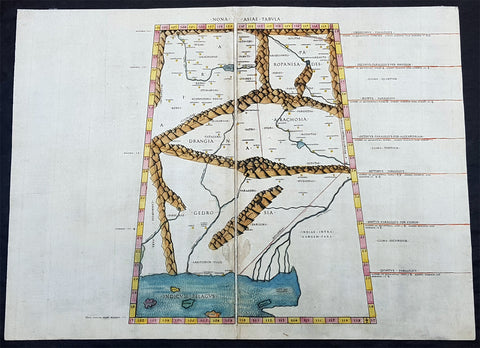
1478 Ptolemy & Buckink Antique Map of Afghanistan, Pakistan, India - Oldest Map on the Market
Antique Map
- Title : Nona Asiae Tabula
- Ref #: 92609
- Size: 22 1/4in x 16 1/2in (565mm x 420mm)
- Date : 1478
- Condition: (A+) Fine Condition
Description:
The first printed book, with maps, was published in Bologna, Italy in 1477. The maps were engraved by Taddeo Crivelli (active 1451 - 1479) after the text of the famous 1st century Alexandrian cartographer Claude Ptolemy. Only 26 editions of this atlas were printed with all remaining editions, today, in institutional hands.
In the following year 1478, the second atlas was printed, again after Ptolemy, in Rome by Konrad Sweynheym & completed by Arnold Buckink. These maps are considered far superior in detail and quality to the 1477 1st edition and are the earliest maps available to the modern day collector.
This map of what is today Pakistan, Afghanistan and parts of India, the 9th in the Asian series of Ptolems 27 maps, was published by Arnold Buckinck in Claudii Ptolemaei Alexandrini philosophi Geographiam Romae after the death of his predecessor Conrad Sweynheym.
Considering this is one of the earliest books ever published the typeface and characteristics of these maps and text are extraordinary. Of the engraved editions of Ptolemys Geographia the maps in the Rome edition are some of the finest and only beaten a 100 years later by Gerard Mercator in his 1578 edition of Geographia.
This large map is in fine condition, on strong sturdy and stable paper the printing is heavy and clear. The colour is original, clear and bright. There is some light discolouration to the paper, along with some light soiling two thirds down the center of the map with some show-through on the verso. Overall in fantastic condition and a unique addition to any collection.
General Definitions:
Paper thickness and quality: - Heavy and stable
Paper color : - off white
Age of map color: - Original
Colors used: - Yellow, green, blue, pink
General color appearance: - Authentic
Paper size: - 22 1/4in x 16 1/2in (565mm x 420mm)
Plate size: - 22 1/4in x 16 1/2in (565mm x 420mm)
Margins: - Min 1/2in (12mm)
Imperfections:
Margins: - Light soiling, age toning, old neutralised tape mark bottom right
Plate area: - Neutralised tape mark bottom right
Verso: - Soiling, age toning, old neutralised tape mark
Background:
The first published edition of Ptolemys Geographia with maps, engraved by Taddeo Crivelli, in Bologna, 1477. Unusually, this edition contained 26 maps, with one of the Asia maps divided up among three neighbouring sheets. With the exception of Palestine, these are the first regional maps of any of these various countries.
Unfortunately for the publishers, this atlas was not a commercial success, and today only twenty-six examples of the atlas are recorded.
One explanation of the failure, is that the publishers do not seem to have been fully mastered the intricacies and problems of engraving, and printing from, copper-plates, an art, which, after all, was very new and experimental. These problems were more successfully addressed by a German printer, Conrad Sweynheym, who was working on an edition of Ptolemy in Rome in the same period. Unfortunately, he did not live to see the volume appear, but his successor, Arnold Buckinck, saw the atlas through the press, in 1478.
The Rome Ptolemy contained 27 maps, with the same geographical coverage as the 1477 Ptolemy. Of the engraved editions of Ptolemys Cosmographia the maps in the Rome edition are the finest fifteenth century examples, and second only to Mercators maps, from his 1578 edition. One explanation for this was the use of individual punches to stamp letters onto the printing plates, rather than engraving them. This allowed much greater uniformity than lettering-engravers were able to achieve, and gives a very pleasing overall effect. The atlas proved popular, and three successive editions (to 1508) followed, although only about forty examples of the first edition are recorded today.
Ptolemy, Claudius 90 A.D.-168 A.D.
Claude Ptolemy was a celebrated astronomer, mathematician, and geographer who lived in Alexandria in the 2nd century AD. Although his thinking influenced contemporary Arab geographers, little was known of his work in the West until manuscripts from Constantinople reached Italy in about 1400. These manuscripts were written in Greek and contained the names of every city, island, mountain and river known to the many travellers interviewed by Ptolemy. In addition, the latitude and longitude of each of the resulting eight thousand locations were also recorded. They were translated into Latin by 1401 and appeared in print by 1475. The earliest Byzantine manuscript maps, drawn by analysing the Ptolemy figures, date from the twelfth century. A number of hand-drawn copies were made in Italy throughout the early fifteenth century to accompany Ptolemys text.
Ptolemy stressed the importance of accurate observations in order to calculate latitude and longitude, and laid down the principals of systematic cartography that remain to this day. Obviously there are many errors in Ptolemys maps, due to the limited extent of basic geographic information at that time and the lack of a method of determining accurate longitudes. Judged by modern standards, the basic shortcoming of the Ptolemy world map is the small area it portrays. The Mediterranean is fairly well depicted, but is greatly exaggerated in length (Longitudinally). The effect of this, combined with Ptolemys disregard for Eratosthenes extremely accurate estimate of the earths circumference (c. 200 B.C.) and the use of a Posidonius much smaller flawed estimate (c.50 B.C.) implied a much shorter distance across that part of the unknown earths surface not drawn on the map. Columbus and his contemporaries based their exploratory ventures on Ptolemys calculations and, like him, had no idea of the vast New World to the west, interposed between Europe and Asia.
Work on the first printed atlas from the text of Ptolemy was started in 1473 and finally published in 1478. A crude copy of this atlas was produced and published by some dissident workers in 1477 in order to be first. However, the plates for the 1478 were done prior to the pirated issue and thus the 1478 atlas holds the title of the first Atlas of the world. There are very few surviving examples of this atlas and individual maps.
Ptolemys Geographia The first published edition of Ptolemys Geographia with maps, engraved by Taddeo Crivelli, was issued in Bologna in 1477. Unusually, this edition contained 26 maps, with one of the Asia maps divided up among three neighbouring sheets. With the exception of Palestine, these are the first regional maps of any of these various countries.
Unfortunately for the undertakers, this atlas seems not to have been a commercial success, and today only twenty-six examples of the atlas are recorded, with all but one in institutional libraries.
One explanation of the failure is that the publishers do not seem to have been fully mastered the intricacies and problems of engraving, and printing from, copper-plates, an art, which, after all, was very new and experimental. These problems were more successfully addressed by a German printer, Conrad Sweynheym, who was working on an edition of Ptolemy in Rome in the same period. Unfortunately, he did not live to see the volume appear, but his successor, Arnold Buckinck, saw the atlas through the press, in 1478.
The Rome Ptolemy contained 27 maps, with the same geographical coverage as the 1477 Ptolemy. Of the engraved editions of Ptolemy Cosmographia the maps in the Rome edition are the finest fifteenth century examples, and second only to Mercators maps, from his 1578 edition. One explanation for this was the use of individual punches to stamp letters onto the printing plates, rather than engraving them. This allowed much greater uniformity than lettering-engravers were able to achieve, and gives a very pleasing overall effect. The atlas proved popular, and three successive editions (to 1508) followed, although only about forty examples of the first edition are recorded today.
Konrad Sweynheim & Arnold Pannartz were two printers of the 15th century.
Pannartz died about 1476, Sweynheym in 1477. Pannartz was, perhaps, a native of Prague, and Sweynheym of Eltville near Mainz. Gottfried Zedler believed (Gutenberg-Forschungen, 1901) that Sweynheym worked at Eltville with Gutenberg in 1461-1464. Whether Pannartz had been connected with Sweynheym in Germany is not known. It is certain that the two brought Gutenbergs invention to Italy.
The Benedictine abbey of Subiaco was the cradle of Italian printing. Probably Cardinal Giovanni of Turrecremata, who was Abbot in commendam of Subiaco, summoned the two printers there. They came in 1464. The first book that they printed at Subiaco was a Donatus; it has not, however, been preserved. The first book printed in Italy that is extant was a Cicero, De oratore (now in the Buchgewerbehaus at Leipzig), issued in September, 1465. It was followed by Lactantius, De divinis institutionibus, in October, 1465, and Augustines De civitate Dei (1467). These four impressions from Subiaco are of particular importance, because they abandon the Blackletter of the early German books. In Italy, Roman characters were demanded. Pannartz and Sweynheym, however, did not produce a pure but only a half Roman type with Blackletter-like characteristics.
In 1467, the two printers left Subiaco and settled at Rome, where the brothers Pietro and Francesco Massimo placed a house at their disposal. The same year, they published an edition of Ciceros letters that gave its name to the cicero, the Continental equivalent of the pica. Their proof and manuscript reader was Giovan de Bussi, since 1469 Bishop of Aleria in Corsica.
The works they printed are given in two lists of their publications, issued in 1470 and 1472. Up to 1472, they had published twenty-eight theological and classical volumes, namely, the Bible, Lactantius, Cyprian, Augustine, Jerome, Leo the Great, Thomas Aquinas, Cicero, Apuleius, Gellius, Virgil, Livy, Strabo, Pliny, Quintilian, Suetonius, Ovid, etc., in editions varying from 275 to 300 copies each, in all 12,475 volumes. But the printers shared the fate of their master, Gutenberg; they could not sell their books, and fell into want.
In 1472, they applied to Pope Sixtus IV for Church benefices. From this we know that both were ecclesiastics: Pannartz of Cologne and Sweynheym of Mainz. The pope had a reversion drawn up for them, a proof of his great interest in printing. In 1474, Sweynheym was made a canon at St. Victor at Mainz. It is not known whether Pannartz also obtained benefice. Perhaps the pope also aided them; at any rate, they printed eighteen more works in 1472 and 1473. After this they separated. Pannartz printed by himself thirteen further volumes. Sweynheym took up engraving on metal and executed the fine maps for the Cosmography of Ptolemy, the first work of this kind, but died before he had finished his task.
Please note all items auctioned are genuine, we do not sell reproductions. A Certificate of Authenticity (COA) can be issued on request.

1609 Henricus Hondius Antique Map of India, China & SE Asia
- Title : India Orientalis
- Size: 22in x 18 1/2in (560mm x 470mm)
- Condition: (A+) Fine Condition
- Date : 1609
- Ref #: 75001
Description:
This beautifully engraved hand coloured original map of India, SE Asia & the East Indies was published in Gerard Mercator's French edition of Atlas sive Cosmographicae published by Henricus Hondius and Jan Jansson in 1609..
Background: One of the finest of the early Dutch maps of the region published. It was first published in 1606 as one of the 37 new maps engraved by Jodocus Hondius' for Mercators Atlas.
The map extends from India to the coasts of Southern China including the Pearl Jodocus HondiusRiver Estuary, Canton and Formosa. It also includes all of the Malay peninsula and Indochina, northern Borneo and the Philippines.
Hondius shared the classic view of the SE Asian River Systems, mapping five rivers from the Mekong westward, as originating in a lake in the Himalayas. The kingdom of Lan Na is shown originating in what is today northern Thailand and a depiction of the Mergui Archipelago off the Burmese portion of the Malay Peninsula as an island studded sea. The old capital of Siam, Ayuthaya, is shown on an island in the Gulf of Siam.
The decorative detail includes a large sea monster and an oriental junk in the Bay of Bengal as well as fine scrollwork title & scale cartouches. One of the most interesting & unusual features of the Southern Malay peninsula is its dissection in two, the southern part becoming an island just south of Malacca where it is separated from the rest of the peninsula by a large north-easterly channel. (Ref: Koeman; M&B; Tooley)
General Description:
Paper thickness and quality: - Heavy and stable
Paper color: - off white
Age of map color: - Early
Colors used: - Yellow, green, red, brown.
General color appearance: - Authentic and fresh
Paper size: - 22in x 18 1/2in (560mm x 470mm)
Plate size: - 19 1/4in x 14in (490mm x 355mm)
Margins: - Min 1in (25mm)
Imperfections:
Margins: - None
Plate area: - None
Verso: - None
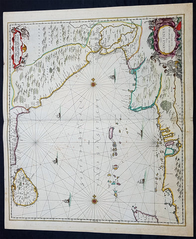
1650 Jan Jansson Large Rare Antique Map of India and The Bay of Bengal
- Title : Sinus Gangeticus Vulgo Golfo De Bengala
- Date : 1650
- Condition: (A+) Fine Condition
- Ref: 60604
- Size: 23 1/2in x 20in (600mm x 510mm)
Description:
This exceedingly impressive hand coloured original antique map of the Bay of Bengal, India - stretching from Sri Lanka to the west coast of Thailand - was published by Jan Jansson in the 1650 Edition of his "Water World" atlas Atlantis Majoris. There were far fewer editions of this atlas published than Janssons more prevalent Atlas Novus.
General Description:
Paper thickness and quality: - Heavy and stable
Paper color: - off white
Age of map color: - Original
Colors used: - Green, red, orange, yellow, blue
General color appearance: - Authentic
Paper size: - 23 1/2in x 20in (600mm x 510mm)
Plate size: - 21 1/2in x 19in (545mm x 485mm)
Margins: - Min 1/2in (12mm)
Imperfections:
Margins: - None
Plate area: - Very light spotting
Verso: - Very light spotting
Background:
Maps of India, much distorted in shape, appear in most world atlases from the time of Ptolemy, the earliest usually showing India as a relatively small extension of Southern Asia, dominated by the very large island of Taprobana (Ceylon). In later sixteenth-century maps de Jode, Ortelius and Mercator gave a much improved outline of both lands but India was still shown too small in relation to the whole continent. Most publishers in the seventeenth century continued to issue maps but with little improvement in detail until about 1719 when a French Jesuit priest, Father Jean Bouchet, compiled an accurate map of South India, subsequently used by G. Delisle (1723), Homann Heirs (1735) and by J. B. B. d'Anville, then the French East India Company's cartographer, as the basis for his greatly improved maps in 1737 and 1752.
In the next decade Alexander Dalrymple published a collection of newly surveyed coastal charts and plans of ports and, about the same time, in 1764, James Rennell, a young British Army officer who showed a remarkable aptitude for surveying, was appointed - at the age of 21- Surveyor General of Bengal; he immediately set in motion a comprehensive survey of the Company's lands, subsequently publishing maps of Bengal and other provinces which eventually formed The &ngal Atlas (1779). His other works included a Map of Hindoustan (1782-85) and The Provinces of Delhi, Agra etc and the Indian Peninsula (1788-94). These maps by Reunell provided the basis for a Trigonometrical Survey of India which was initiated in 1802 and for splendid maps published in London by Cary, the Arrowsmiths (1804-22) and the Wylds. (Ref: Tooley, M&B)
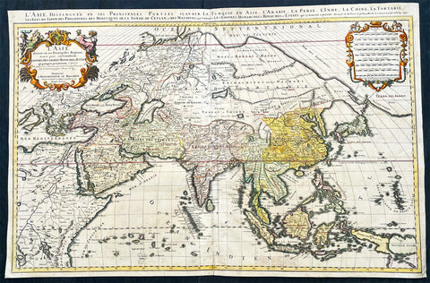
1696 Alexis Hubert Jaillot Large Antique Map of Asia - Saudi Arabia to Australia
- Title : L' Asie divisee en ses Principales Regions....Hubert Jaillot....1696
- Ref #: 17022
- Size: 35 1/2in x 23in (900mm x 585mm)
- Date : 1696
- Condition: (A) Very Good Condition
Description:
This very large original hand coloured antique map of Asia, from Arabia to the Gulf of Carpentaria, Australia, was engraved in 1696 - dated in title - and was published by Alexis Hubert Jaillot in his monumental Atlas Nouveau.
General Definitions:
Paper thickness and quality: - Heavy and stable
Paper color : - off white
Age of map color: - Original
Colors used: - Yellow, green, blue, pink
General color appearance: - Authentic
Paper size: - 35 1/2in x 23in (900mm x 585mm)
Plate size: - 34 1/2in x 22 1/2in (875mm x 570mm)
Margins: - Min 1/2in (15mm)
Imperfections:
Margins: - Light age toning in margin
Plate area: - Re-enforced along centerfold, light age toning, old ink text to bottom of map
Verso: - Soiling
Background:
The map include lines of latitude and longitude, some topographical details, location of settlements, rivers, and lakes (including the lakes Parime, thought to be where the fabulous El Dorado was located) as well as the boundaries of the possessions of the European claimants to South America.
Extremely decorative cartouche with dedication to Le Dauphin, and his coat of arms in top.
After Nicolas Sanson, Hubert Jaillot and Pierre Duval were the most important French cartographers of the seventeenth & eighteenth centuries. Jaillot, originally a sculptor, became interested in geography after his marriage to the daughter of Nicolas Berey (1606-65), a famous map colourist, and went into partnership in Paris with Sanson's sons. There, from about 1669, he undertook the re-engraving, enlarging and re-publishing of the Sanson maps in sheet form and in atlases, sparing no effort to fill the gap in the map trade left by the destruction of Blaeu's printing establishment in Amsterdam in 1672. Many of his maps were printed in Amsterdam (by Pierre Mortier) as well as in Paris. One of his most important works was a magnificent sea atlas, Le Neptune François, published in 1693 and compiled in co-operation with J D Cassini. This was re-published shortly afterwards by Pierre Mortier in Amsterdam with French, Dutch and English texts, the charts having been re-engraved. Eventually, after half a century, most of the plates were used again as the basis for a revised issue published by J N Bellin in 1753.(Ref: Tooley; M&B)
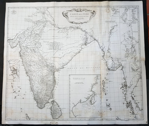
1752 D Anville Large Original Antique Map of India Sri Lanka Burma Siam - Scarce
- Title : Carte De L Inde Dressee Pour La Compagnie Des Indes...1752
- Size: 43in x 37 1/2in (1.1m x 950mm)
- Ref #: 92320
- Date : 1752
- Condition: (A) Very Good Condition
Description:
This large finely engraved scarce and highly detailed original antique map of India, Sri Lanka Burma & Thailand was engraved by Guillaume de la Haye in 1752 - dated in the tile cartouche - and was published in Jean-Baptiste Bourguinon D\'Anville\'s large elephant folio atlas Atlas Generale.
General Definitions:
Paper thickness and quality: - Heavy and stable
Paper color : - off white
Age of map color: -
Colors used: -
General color appearance: -
Paper size: - 43in x 37 1/2in (1.1m x 950mm)
Plate size: - 41in x 35in (1.04m x 890mm)
Margins: - Min 1in (25mm)
Imperfections:
Margins: - Spotting
Plate area: - Spotting, aging toning along folds as issued
Verso: - Spotting, aging toning along folds as issued
Background:
The map is drawn from numerous sources, including Ptolemy, Turkish and Indian geographies, and Jesuit surveys. More contemporary works by Bouchet in 1719 and Boudier in 1734 are seen both in the detail and inset river maps. The map reflects the level of knowledge of India & SE Asia at the time, especially of the interiors. The map has excellent detail of Southern India and coastlines were trade had been happening for centuries, but a conspicuous absence of detail of the northern interior
There are seven Inset maps that include the environs of Goa, entrance of the Ganges River and a wonderfully detailed depiction of the entrance to the Hugli River and other river tributes.
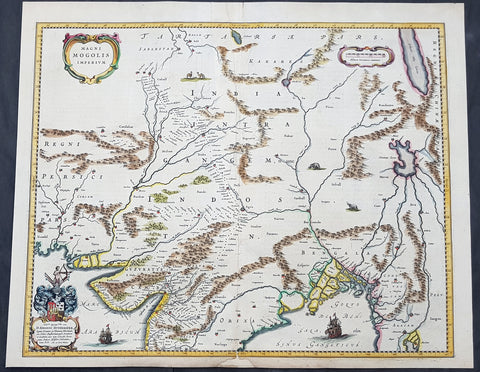
1640 Joan Blaeu Antique Map Mughal Empire of Northern India, Tibet, Nepal, Asia
- Title : Magni Mogolis Imperium
- Size: 22in x 18in (560mm x 465mm)
- Condition: (A) Very Good Condition
- Date : 1640
- Ref #: 42017
Description:
This original hand coloured copper plate engraved antique map of Mughal Empire of Northern India, Tibet, Nepal and central Asia was published by Joan Blaeu in the 1640 edition of Atlas Nouvs
General Definitions:
Paper thickness and quality: - Heavy and stable
Paper color : - off white
Age of map color: - Original
Colors used: - Blue, pink, red, green, yellow
General color appearance: - Authentic
Paper size: - 22in x 18in (560mm x 465mm)
Plate size: - 20 1/2in x 16 1/2in (515mm x 420mm)
Margins: - Min 1/2in (12mm)
Imperfections:
Margins: - Small section of bottom margin restored
Plate area: - Light creasing
Verso: - Centerfold re-enforced
Background:
This map centers on the Mughal capital of Agra, with the map covering, roughly, from Kabul to Orissa and Deccan, and from Persia to Bengal. It depicts the empire prior to the conquest of Orissa and Deccan, most likely during the reign of Shah Jahan, of Taj Mahal fame. Relief is shown pictorially. An elaborate title cartouche appears in the upper left quadrant. The map is embellished with images of tigers, elephants, caravans, and galleons.
There is much of interest. In particular, is the map detailed breakdown of the caravan network between Gujarat and Agra, between Agra and the desert outpost of Jaisalmer, and between Agra and the Silk Road center of Kabul. While the map does not show roads, for surely none as such existed at the time, it does show the network of towns, waystations and caravanserai built to support the bustling trade system.
The apocryphal Lake of Chiamay appears just north of the Bay of Bengal as the source of four important Southeast Asian river systems including the Irrawaddy, the Dharla, the Chao Phraya, and the Brahmaputra. The curious Lake of Chiamay (also called Chiam-may or Chian-may), roughly located in the area of Assam but sometimes as far north as Tibet and China, began to appear in maps of this region as early as the 16th century and persisted well into the mid 18th century. Its origins are unknown but may originate in a lost 16th century geography prepared by the Portuguese scholar Jao de Barros. It was speculated to be the source of five important Southeast Asian River systems and was mentioned in the journals of Sven Hedin. There are even records that the King of Siam led an invasionary force to take control of the lake in the 16th century. Nonetheless, the theory of Lake Chiamay was ultimately disproved and it disappeared from maps entirely by the 1760s.
There are two states of this map, the present example being the first state, first issued in 1638 by Henricus Hondius, and the second state a few years later in 1641 by Jan Jannson. With the exception of the signature imprint, the plates are identical. (Ref: Koeman; M&B)
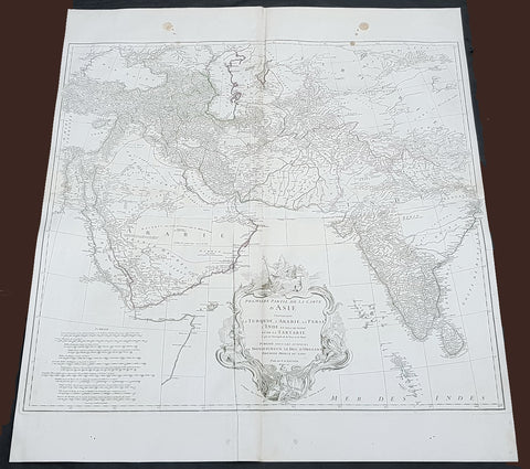
1751 D Anville Large Antique Map of West Asia - Saudi Arabia, Persia & India
- Title : Premiere Partie de la Carte D Asie contrnant La Turquie, L Arabie, La Perse, L Inde...Sr D Anville...MDCCLI
- Size: 35 1/2in x 31 1/2in (900mm x 800mm)
- Condition: (A+) Fine Condition
- Date : 1751
- Ref #: 92314
Description:
This large original copper plate engraved antique map of West Asia from Saudi Arabia, Persia and India was engraved in 1751 - dated in the tile cartouche - and was published in Jean-Baptiste Bourguinon D Anvilles large elephant folio atlas Atlas Generale.
General Definitions:
Paper thickness and quality: - Heavy and stable
Paper color : - off white
Age of map color: - Original
Colors used: - Red
General color appearance: - Authentic
Paper size: - 35 1/2in x 31 1/2in (900mm x 800mm)
Plate size: - 31 1/2in x 29 1/2in (810mm x 750mm)
Margins: - Min 1/2in (12mm)
Imperfections:
Margins: - Two tan spots in top margin into border
Plate area: - Light creasing
Verso: - Light soiling
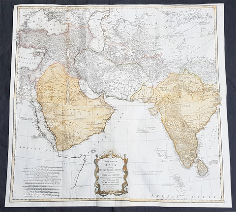
1755 D Anville & Bolton Large Antique Map of Asia, Turkey, Saudi Arabia, India
- Title : First Part of Asia being Turkey, Arabia, Persia most of India and Tartary Performed by the Sr D Anville...Revised and Improved by Mr Bolton MDCCLV (1755)
- Size: 31 1/2in x 30in (800mm x 765mm)
- Condition: (A) Very Good Condition
- Date : 1755
- Ref #: 91298
Description:
This large original hand coloured, copper plate engraved antique map of western Asia from Turkey to Saudi Arabia to India by Solomon Bolton, after the French cartographer Jean Baptiste Bourguignon D Anville, was engraved in 1755 - dated - and published in the 1765 edition of Malachy Postlethweyts monumental 2 Volume tomes on The Universal Dictionary of Trade & Commerce concentrating on various states of trade, including slavery, between England and America published between 1751 & 1774.
General Definitions:
Paper thickness and quality: - Heavy and stable
Paper color : - off white
Age of map color: - Early
Colors used: - Yellow, green, blue, pink
General color appearance: - Authentic
Paper size: - 31 1/2in x 30in (800mm x 765mm)
Plate size: - 31 1/2in x 30in (800mm x 765mm)
Margins: - Min 1/2in (10mm)
Imperfections:
Margins: - Top margin extended from plate mark
Plate area: - Folds as issued, small restoration to left fold
Verso: - Folds as issued
Background:
Postlethweyt, Malachy 1707 – 1767
Malachy Postlethweyts Dictionary of Trade & Commerce: A monumental dictionary of trade and commerce. It is based in part on the Dictionnaire universel de Commerce (Paris: 1723-30) of Jacques Savary de Bruslon, under whose name it is often catalogued, but has been adapted by Postlethwayt for a British audience, with substantial enlargements and improvements, and entirely new material relating to England and her colonies. Postlethwayt devoted twenty years to the preparation of the dictionary, which was first published in 1751-55 & includes a description of British affairs in North America since the peace of 1763.
As with his other works, the dictionary demonstrates Postlethway’s deep commitment to the expansion and strengthening of English trade. Included are entries for geographical locations (Africa, Antilles, Canada, Japan, Louisiana, &c.), products (brandy, cardamom, codfish, diamonds, sugar, &c.), trading companies (Dutch East India Company, English African Company, &c.), treaties of commerce, and a vast range of other information of value to merchants (bankruptcy, currency, bills of exchange, brokerage, exportation, landed interest, privateering, &c.). The Dictionary is also important for containing almost the whole substance of Richard Cantillon’s Essay on Commerce, its first appearance in print.
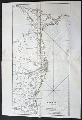
1753 D Anville Large Original Antique Map of SE Coromandel Coast of India - Rare
- Title : Coromandel par Le Sr D Anville...1753
- Size: 39 1/2in x 27in (1.1m x 685mm)
- Ref #: 92321
- Date : 1753
- Condition: (A) Very Good Condition
Description:
This large finely engraved scarce and highly detailed original antique map of South East Coast of India, the Coromandel Coast was engraved by Guillaume de la Haye in 1753 - dated in the tile cartouche - and was published in Jean-Baptiste Bourguinon D\'Anville\'s large elephant folio atlas Atlas Generale.
General Definitions:
Paper thickness and quality: - Heavy and stable
Paper color : - off white
Age of map color: -
Colors used: -
General color appearance: -
Paper size: - 39 1/2in x 27in (1.1m x 685mm)
Plate size: - 38in x 19 1/2in (970mm x 495mm)
Margins: - Min 1/2in (12mm)
Imperfections:
Margins: - Light spotting to right of image
Plate area: - Light spotting to right of image
Verso: - Light spotting to right of image
Background:
The Coromandel Coast is the southeastern coast region of the Indian Subcontinent, between the Eastern Ghats and the Bay of Bengal of the Indian Ocean. The coastline runs between False Divi Point in the north to Kanyakumari in the south. Its definition can also include the northwestern coast of the island of Sri Lanka.
By late 1530 the Coromandel Coast was home to three Portuguese settlements at Nagapattinam, São Tomé de Meliapore, and Pulicat. Later, in the 17th and 18th centuries, the Coromandel Coast was the scene of rivalries among European powers for control of the India trade. The British established themselves at Fort St George (Madras) and Masulipatnam, the Dutch at Pulicat, Sadras and Covelong, the French at Pondicherry, Karaikal and Nizampatnam, the Danish in Dansborg at Tharangambadi.
The Coromandel Coast supplied Indian Muslim eunuchs to the Thai palace and court of Siam (modern Thailand). The Thai at times asked eunuchs from China to visit the court in Thailand and advise them on court ritual since they held them in high regard.
Eventually the British won out, although France retained the tiny enclaves of Pondichéry and Karaikal until 1954. Chinese lacquer goods, including boxes, screens, and chests, became known as \"Coromandel\" goods in the eighteenth century, because many Chinese exports were consolidated at the Coromandel ports.
1755 Antoine Prevost Antique Map of Tharangambadi, Nagapattinam District, Tamil Nadu, India
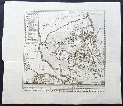
- Title : Carte du District de Tranquebar: Caart des Regtsgebieds van Trankenbar
- Ref #: 61070
- Size: 17in x 15in (430mm x 380mm)
- Date : 1755
- Condition: (A+) Fine Condition
Description:
This large original copper-plate engraved antique map a plan of the city, fort & environs of Tharangambadi, formerly Tranquebar, in Tamil Nadu, India - with separate page Index of Buildings and important landmarks - by Jakob van Schley in 1755, was published in the Dutch edition of Antoine François Prevosts 15 volumes of Histoire Generale des Voyages written by Prevost & other authors between 1746-1790.
General Definitions:
Paper thickness and quality: - Heavy and stable
Paper color : - off white
Age of map color: -
Colors used: -
General color appearance: -
Paper size: - 17in x 15in (430mm x 380mm)
Plate size: - 13in x 13in (305mm x 305mm)
Margins: - Min 1in (25mm)
Imperfections:
Margins: - None
Plate area: - Folds as issued
Verso: - None
Background:
Tharangambadi, formerly Tranquebar, is a town in the Nagapattinam district of the Indian state of Tamil Nadu. It lies 15 kilometres north of Karaikal, near the mouth of a distributary of the Kaveri River. It was a Danish colony from 1620 to 1845, and in Danish it is still known as Trankebar.
The place dates back to 14th century. Masilamani nathar (Shiva) temple was built in 1306, in a land given by Maravarman Kulasekara Pandyan I. As of now, this temple is the oldest monument. Until 1620, when the Danes came, the place was under Thanjavur Nayak kingdom. Danish admiral Ove Gjedde felt the place would be a potential trading centre, made a deal with Raghunatha Nayak and built a fort, which is known as Fort Dansborg. Nevertheless, a jesuit Catholic church was already in place before that, catering for the Indo-Portuguese community. The Catholic church was probably demolished to build the fort. This fort was the residence and headquarters of the governor and other officials for about 150 years.
Among the first Protestant missionaries to set foot in India were two Lutherans from Germany, Bartholomäus Ziegenbalg and Heinrich Pluetschau, who began work in 1705 in the Danish settlement of Tranquebar. Ziegenbalg translated the Old and New Testaments into Tamil, imported a printing press, and printed the New Testament in Tamil in 1714.
The local people were forced to learn the broken Portuguese that was the lingua franca between Indians and Europeans at the time, and later on translated the Bible into the local Tamil language. They also established a printing press, which within a hundred years of its establishment in 1712 had printed 300 books in Tamil. At first they only made little progress in their religious efforts, but gradually the mission spread to Madras, Cuddalore and Tanjore. Today Bishop of Tranquebar is the official title of a bishop in theTamil Evangelical Lutheran Church (TELC) in South India which was founded in 1919 as a result of the German Lutheran Leipzig Mission and Church of Sweden Mission. The seat of the Bishop, the Cathedral and its Church House (\\\"Tranquebar House\\\") is in Tiruchirappalli.
The Zion church was consecrated in 1701, which is the oldest Protestant church in India. In 1718, The New Jerusalem Church was constructed. Moravian Brethren missionaries from Herrnhut, Saxony established the Brethren\\\'s Garden at Porayar near Tranquebar and operated it as a missionary centre for a number of years. An Italian Catholic FatherConstanzo Beschi, who worked in the colony from 1711 to 1740, found himself in conflict with the Lutheran pioneers at Tranquebar, against whom he wrote several polemical works.
Tranquebar was occupied by the British in February 1808 during the Napoleonic Wars but was restored to Denmark following the Treaty of Kiel in 1814 and The Norwegian Declaration of Independence. Along with the Danish settlement of Serampore in Bengal, it was sold to the British in 1845. Tranquebar was then still a busy port, but it later lost its importance after a railway was opened to Nagapattinam.
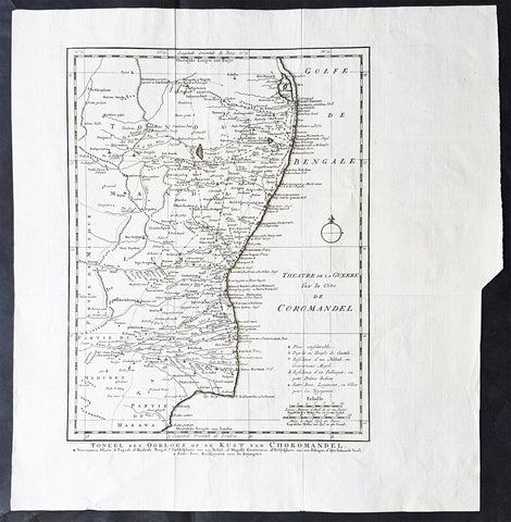
1755 Antoine Prevost Antique Map of Carnatic Wars on the Coromandel Coast, India
- Title : Theatre de la Guerre sur la Cote de Coromandel (Theater of War on the Coromandel Coast)
- Ref #: 61076
- Size: 17in x 15in (430mm x 380mm)
- Date : 1755
- Condition: (A+) Fine Condition
Description:
This large original copper-plate engraved antique map of the Coromandel Coast, India during the Carnatic Wars, by Jakob van Schley in 1755, was published in the Dutch edition of Antoine François Prevosts 15 volumes of Histoire Generale des Voyages written by Prevost & other authors between 1746-1790.
General Definitions:
Paper thickness and quality: - Heavy and stable
Paper color : - off white
Age of map color: -
Colors used: -
General color appearance: -
Paper size: - 17in x 15in (430mm x 380mm)
Plate size: - 13in x 13in (305mm x 305mm)
Margins: - Min 1in (25mm)
Imperfections:
Margins: - None
Plate area: - Folds as issued
Verso: - None
Background:
The Carnatic Wars (also spelled Karnatic Wars) were a series of military conflicts in the middle of the 18th century in India. The conflicts involved numerous nominally independent rulers and their vassals, struggles for succession and territory, and included a diplomatic and military struggle between the French East India Company and the British East India Company. They were mainly fought on the territories in India which were dominated by the Nizam of Hyderabad up to the Godavari delta. As a result of these military contests, the British East India Company established its dominance among the European trading companies within India. The French company was pushed to a corner and was confined primarily to Pondichéry. The East India company\'s dominance eventually led to control by the British Company over most of India and eventually to the establishment of the British Raj.
In the 18th century, the coastal Carnatic region was a dependency of Hyderabad. Three Carnatic Wars were fought between 1746 and 1763.
The Coromandel Coast is the southeastern coast region of the Indian subcontinent, bounded by the Utkal Plains to the north, the Bay of Bengal to the east, the Kaveri delta to the south, and the Eastern Ghats to the west, extending over an area of about 22,800 square kilometres. Its definition can also include the northwestern coast of the island of Sri Lanka.
By late 1530 the Coromandel Coast was home to three Portuguese settlements at Nagapattinam, São Tomé de Meliapore, and Pulicat. In the 17th and 18th centuries, the Coromandel Coast was the scene of rivalries among European powers for control of the India trade. The British established themselves at Fort St George (Madras) and Masulipatnam, the Dutch at Pulicat, Sadras and Covelong, the French at Pondicherry, Karaikal and Nizampatnam, the Danish in Dansborg at Tharangambadi.
The Coromandel Coast supplied Indian Muslim eunuchs to the Thai palace and court of Siam. The Thai at times asked eunuchs from China to visit the court in Thailand and advise them on court ritual since they held them in high regard.
Eventually the British won out, although France retained the tiny enclaves of Pondichéry and Karaikal until 1954. Chinese lacquer goods, including boxes, screens, and chests, became known as Coromandel goods in the 18th century, because many Chinese exports were consolidated at the Coromandel ports.
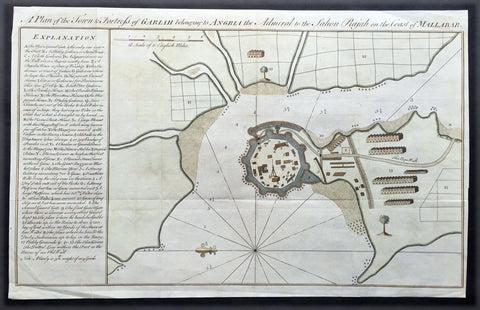
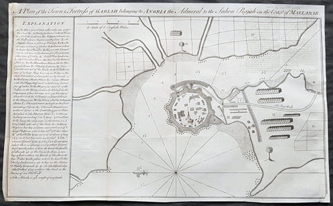
1760 Bowen Antique Map, Plan Fort & Town of Vijaydurg, Maharashtra State, India
- Title : A plan of the town and fortress of Gariah belonging to Angriah the admiral to the Sahou Rajah
- Size: 18 1/4in x 12in (465mm x 305mm)
- Condition: (A+) Fine Condition
- Date : 1760
- Ref #: 21950
Description:
This beautifully hand coloured original copper-plate engraved antique map, a plan of the fort and town of Gheriah, Girye or Gheriya, today called Vijaydurg in Maharashtra state in NW India (485 kms from Mumbai) was published by Emmanual Bowen in 1760.
The map contains many numbered & lettered references to particular areas of interest within the fort, town and surrounds.
General Definitions:
Paper thickness and quality: - Heavy and stable
Paper color : - off white
Age of map color: -
Colors used: -
General color appearance: -
Paper size: - 18 1/4in x 12in (465mm x 305mm)
Plate size: - 18 1/4in x 12in (465mm x 305mm)
Margins: - Min 1/2in (12mm)
Imperfections:
Margins: - Light creasing
Plate area: - Folds as issued
Verso: - Folds as issued
Background:
Vijaydurg is said to be the oldest fort in Sindhudurg coast. In the Pre-Independence era it was also known as Eastern Gibraltar. This is because the fort was almost unconquerable. Under the leadership of Kanhoji Angre, it withstood many naval attacks by the British and the Dutch. Kanhoji Angre died on 4 July 1729 and the Angres control of the fort ended in 1756 after the Peshwa-British Alliance defeated the Angres clan. In 1818 Vijaydurg was completely in the hand of the British Empire.
Kanhoji Angre 1669 – 1729 was a chief of the Maratha Navy in 18th century India. In historical records, he is also known as Conajee Angria or Sarkhel Angré (Sarkhel is a title equal to Admiral of a fleet).
Kanhoji fought against the British, Dutch and Portuguese naval interests on the coasts of India during the 18th century. As a result, his European enemies labeled him a pirate. Despite the attempts of the British and Portuguese to subdue Angre, he remained undefeated until his death.
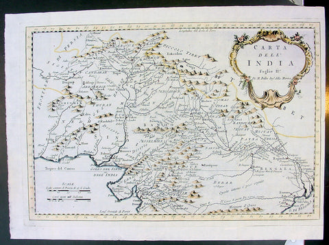
1755 Bellin Original Antique Map Northern India, Pakistan, Tibet & Afghanistan
- Title : Carta Dell India Foglio II..Di M Bellin
- Ref #: 15624
- Size: 14 1/2in x 10 1/2in (370mm x 265mm)
- Date : 1755
- Condition: (A+) Fine Condition
Description:
This fine, original copper-plate engraved antique map of Northern India, Pakistan, Tibet & Afghanistan by Jacques Nicolas Bellin in 1755 was published in Antoine François Prevosts 15 volumes of Histoire Generale des Voyages written by Prevost & other authors between 1746-1790.
General Definitions:
Paper thickness and quality: - Heavy and stable
Paper color : - off white
Age of map color: - Early
Colors used: - Green, yellow, red
General color appearance: - Authentic
Paper size: - 14 1/2in x 10 1/2in (370mm x 265mm)
Plate size: - 13 1/2in x 9 1/2in (345mm x 240mm)
Margins: - Min 1/4in (6mm)
Imperfections:
Margins: - None
Plate area: - Folds as issued
Verso: - None
Background:
One of Antoine Francois Prevosts monumental undertakings was his history of exploration & discovery in 15 volumes titledHistoire Générale des Voyages written between 1746-1759 and was extended to 20 volumes after his death by various authors.
The 20 volumes cover the early explorations & discoveries on 3 continents: Africa (v. 1-5), Asia (v. 5-11), and America (v. 12-15) with material on the finding of the French, English, Dutch, and Portugese.
A number of notable cartographers and engravers contributed to the copper plate maps and views to the 20 volumes including Nicolas Bellin, Jan Schley, Chedel, Franc Aveline, Fessard, and many others.
The African volumes cover primarily coastal countries of West, Southern, and Eastern Africa, plus the Congo, Madagascar, Arabia and the Persian Gulf areas.
The Asian volumes cover China, Korea, Tibet, Japan, Philippines, and countries bordering the Indian Ocean.
Volume 11 includes Australia and Antarctica.
Volumes 12-15 cover voyages and discoveries in America, including the East Indies, South, Central and North America.
Volumes 16-20 include supplement volumes & tables along with continuation of voyages and discoveries in Russia, Northern Europe, America, Asia & Australia.
1760 Bowen Antique Map, Plan Fort & Town of Vijaydurg, Maharashtra State, India
- Title : A plan of the town and fortress of Gariah belonging to Angriah the admiral to the Sahou Rajah
- Size: 18 1/4in x 12in (465mm x 305mm)
- Condition: (A+) Fine Condition
- Date : 1760
- Ref #: 40986-2
Description:
This original copper-plate engraved antique map, a plan of the fort and town of Gheriah, Girye or Gheriya, today called Vijaydurg in Maharashtra state in NW India (485 kms from Mumbai) was published by Emmanual Bowen in 1760.
The map contains many numbered & lettered references to particular areas of interest within the fort, town and surrounds.
General Definitions:
Paper thickness and quality: - Heavy and stable
Paper color : - off white
Age of map color: -
Colors used: -
General color appearance: -
Paper size: - 18 1/4in x 12in (465mm x 305mm)
Plate size: - 18 1/4in x 12in (465mm x 305mm)
Margins: - Min 1/2in (12mm)
Imperfections:
Margins: - Light creasing
Plate area: - Folds as issued
Verso: - Folds as issued
Background:
Vijaydurg is said to be the oldest fort in Sindhudurg coast. In the Pre-Independence era it was also known as Eastern Gibraltar. This is because the fort was almost unconquerable. Under the leadership of Kanhoji Angre, it withstood many naval attacks by the British and the Dutch. Kanhoji Angre died on 4 July 1729 and the Angres control of the fort ended in 1756 after the Peshwa-British Alliance defeated the Angres clan. In 1818 Vijaydurg was completely in the hand of the British Empire.
Kanhoji Angre 1669 – 1729 was a chief of the Maratha Navy in 18th century India. In historical records, he is also known as Conajee Angria or Sarkhel Angré (Sarkhel is a title equal to Admiral of a fleet).
Kanhoji fought against the British, Dutch and Portuguese naval interests on the coasts of India during the 18th century. As a result, his European enemies labeled him a pirate. Despite the attempts of the British and Portuguese to subdue Angre, he remained undefeated until his death.
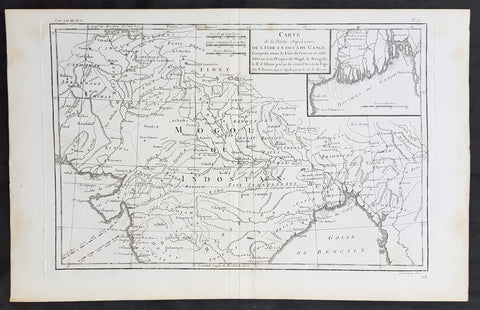
1780 R. Bonne Original Antique Map of Mogul Empire, India, Tibet, Tibet & Ganges
- Title : Carte de la Partie superieure D L Inde en Daca du Gange...M Bonne
- Size: 15in x 10in (380mm x 255mm)
- Ref #: 31661
- Date : 1780
- Condition: (A+) Fine Condition
Description:
This original copper-plate engraved map was published in 1780 edition of Atllas des toutes les parties connues du globe terrestre by Rigobert Bonne & Guillaume Raynal.
General Definitions:
Paper thickness and quality: - Heavy and stable
Paper color : - off white
Age of map color: -
Colors used: -
General color appearance: -
Paper size: - 15in x 10in (380mm x 255mm)
Plate size: - 13in x 9in (330mm x 230mm)
Margins: - Min 1in (25mm)
Imperfections:
Margins: - None
Plate area: - None
Verso: - None
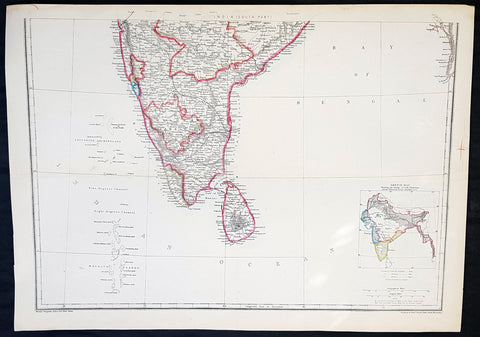
1857 Edward Weller Large Antique Map of Southern India & Sri Lanka, Ceylon
- Title : India (South Part)
- Ref #: 40996
- Size: 18in x 13in (470mm x 330mm)
- Date : 1857
- Condition: (A+) Fine Condition
Description:
This original lithograph hand coloured antique map by Edward Weller was engraved by Day & Co. and was published in the 1857 edition of The Dispatch Atlas; a compilation of maps Weller had already published in The Weekly Dispatch.
General Definitions:
Paper thickness and quality: - Heavy and stable
Paper color : - off white
Age of map color: - Original
Colors used: - Yellow, Green, pink
General color appearance: - Authentic
Paper size: - 18in x 13in (470mm x 330mm)
Plate size: - 18in x 13in (470mm x 330mm)
Margins: - Min 1/2in (10mm)
Imperfections:
Margins: - None
Plate area: - None
Verso: - None
Weller, Edward 1819 – 1884
Weller was a London-based engraver, cartographer and publisher, working from offices in Red Lion Square and later, Bloomsbury. Amongst his considerable portfolio were various atlases, many of which focussed on the educational publishing market. Having established his credentials as an engraver of finely detailed works, he sold maps to be published in a number of regular magazines and pamphlets, perhaps the best known being The Dispatch Atlas; a compilation of maps Weller had already published in The Weekly Dispatch. Although Weller usually engraved the maps himself, he did work in partnership with others, particularly John Dower for this 1858 and 1863 volume. Weller also published The Crown Atlas in 1871.
The Dispatch Atlas featured well over one hundred superbly detailed steel plate engraved maps, usually with simplistic, single colour outline hand colouring, and a distinctive header style. Most English counties featured, some of which were divided onto separate sheets, affording space to engrave in even greater detail. The maps of North and South Devonshire for example include such details as individual property names, as do those of the Northern and Southern parts of Hampshire.
After Wellers death in 1884, many of these astonishingly detailed plates were sold on to other map makers, including George Washington Bacon, who, whilst retaining the level of detail, expanded the printing area of each plate, adding more precise and varied hand colouring in keeping with the final decades of the century.
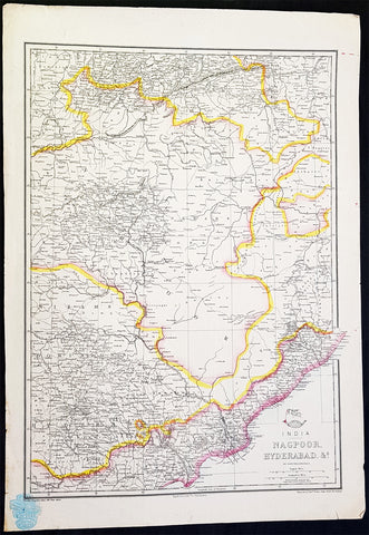
1857 Edward Weller Large Antique Map of Hyderabad & Nagpur Regions of India
- Title : India Nagpoor, Hyderabad
- Ref #: 70490
- Size: 18in x 13in (470mm x 330mm)
- Date : 1857
- Condition: (A+) Fine Condition
Description:
This original lithograph hand coloured antique map by Edward Weller was engraved by Day & Co. and was published in the 1857 edition of The Dispatch Atlas; a compilation of maps Weller had already published in The Weekly Dispatch.
General Definitions:
Paper thickness and quality: - Heavy and stable
Paper color : - off white
Age of map color: - Original
Colors used: - Yellow, Green, pink
General color appearance: - Authentic
Paper size: - 18in x 13in (470mm x 330mm)
Plate size: - 18in x 13in (470mm x 330mm)
Margins: - Min 1/2in (10mm)
Imperfections:
Margins: - None
Plate area: - None
Verso: - None
Edward Weller 1819 - 1884; was a London-based engraver, cartographer and publisher, working from offices in Red Lion Square and later, Bloomsbury. Amongst his considerable portfolio were various atlases, many of which focussed on the educational publishing market. Having established his credentials as an engraver of finely detailed works, he sold maps to be published in a number of regular magazines and pamphlets, perhaps the best known being The Dispatch Atlas; a compilation of maps Weller had already published in The Weekly Dispatch. Although Weller usually engraved the maps himself, he did work in partnership with others, particularly John Dower for this 1858 and 1863 volume. Weller also published The Crown Atlas in 1871.
The Dispatch Atlas featured well over one hundred superbly detailed steel plate engraved maps, usually with simplistic, single colour outline hand colouring, and a distinctive header style. Most English counties featured, some of which were divided onto separate sheets, affording space to engrave in even greater detail. The maps of North and South Devonshire for example include such details as individual property names, as do those of the Northern and Southern parts of Hampshire.
After Wellers death in 1884, many of these astonishingly detailed plates were sold on to other map makers, including George Washington Bacon, who, whilst retaining the level of detail, expanded the printing area of each plate, adding more precise and varied hand colouring in keeping with the final decades of the century.
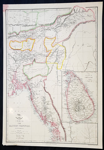
1858 Edward Weller Large Antique Map of Bangladesh, Assam, Sri lanka Ceylon
- Title : India The Eastern Provinces by Edward Weller
- Ref #: 70495
- Size: 18in x 13in (470mm x 330mm)
- Date : 1858
- Condition: (A+) Fine Condition
Description:
This original lithograph hand coloured antique map by Edward Weller was engraved by Day & Co. and was published in the 1858 edition of The Dispatch Atlas; a compilation of maps Weller had already published in The Weekly Dispatch.
General Definitions:
Paper thickness and quality: - Heavy and stable
Paper color : - off white
Age of map color: - Original
Colors used: - Yellow, Green, pink
General color appearance: - Authentic
Paper size: - 18in x 13in (470mm x 330mm)
Plate size: - 18in x 13in (470mm x 330mm)
Margins: - Min 1/2in (10mm)
Imperfections:
Margins: - None
Plate area: - None
Verso: - None
Weller, Edward 1819 – 1884
Weller was a London-based engraver, cartographer and publisher, working from offices in Red Lion Square and later, Bloomsbury. Amongst his considerable portfolio were various atlases, many of which focussed on the educational publishing market. Having established his credentials as an engraver of finely detailed works, he sold maps to be published in a number of regular magazines and pamphlets, perhaps the best known being The Dispatch Atlas; a compilation of maps Weller had already published in The Weekly Dispatch. Although Weller usually engraved the maps himself, he did work in partnership with others, particularly John Dower for this 1858 and 1863 volume. Weller also published The Crown Atlas in 1871.
The Dispatch Atlas featured well over one hundred superbly detailed steel plate engraved maps, usually with simplistic, single colour outline hand colouring, and a distinctive header style. Most English counties featured, some of which were divided onto separate sheets, affording space to engrave in even greater detail. The maps of North and South Devonshire for example include such details as individual property names, as do those of the Northern and Southern parts of Hampshire.
After Wellers death in 1884, many of these astonishingly detailed plates were sold on to other map makers, including George Washington Bacon, who, whilst retaining the level of detail, expanded the printing area of each plate, adding more precise and varied hand colouring in keeping with the final decades of the century.