
Alain Manesson Mallet (1630 - 1706)
Profile :
Alain Manesson Mallet was a French cartographer, military engineer, and geographer, born in 1630 in Paris. He is best known for his works in cartography, including the influential atlas "Description de l'Univers", which was first published in 1683. Mallet's atlas was notable for its detailed maps and illustrations, which covered a wide range of geographic regions and included information on history, culture, and natural resources.
Mallet was well-educated and trained in both military engineering and cartography. He served in the French army as a captain of foot, and later as a lieutenant of artillery. During his time in the military, Mallet was involved in several campaigns and sieges, and his experience in surveying and mapping proved invaluable.
After leaving the military, Mallet pursued a career in cartography and published several important works, including "Description de l'Univers" and "Les Travaux de Mars ou l'Art de la Guerre", which focused on military engineering. He also worked on maps for other publications, including atlases and travel guides.
Mallet's maps were known for their accuracy and attention to detail, and his work was highly regarded by his contemporaries. His influence on the field of cartography continued long after his death in 1706, with his maps and atlases remaining popular among collectors and scholars to this day.
Alain Manesson Mallet (1)
1683 Mallet Antique Map of Australia Cape York Peninsula Gulf of Carpenteria PNG
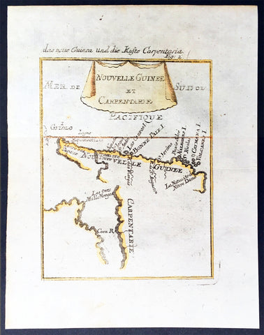
- Title : Nouvelle Guinee et Carpentarie
- Ref #: 50601
- Size: 8in x 6in (205mm x 152mm)
- Date : 1682
- Condition: (A+) Fine Condition
Description:
This hand coloured original antique very early map of Cape York Peninsula, the Gulf of Carpenteria and New Guinea - depicted before the Torres Strait was charted - was published as part of the 1683 edition of Alain Manesson Mallet's 1630 - 1706 Description de l' Univers.
Background:
The first detailed published map to show any part of Queensland (Tully). Shows New Guinea , the east coast of Cape York Peninsula and part of Arnhem Land.
Although not a particularly large map, the significance of Mallet's map of Carpentaria and New Guinea is underrated. It is essentially the first map to concentrate specifically on the Dutch discoveries in Queensland by Jan Cartenszoon in the Pera and the Arnhem that left Ambon on 21 January 1623 and reached the western side of Cape York Peninsula on 12 April. Although De Jode's rare and famous map 'Novae Guineae Forma & Situs', published almost a century earlier also charts the same area, it shows a fictitious Queensland based on the contemporary beliefs of a 'Terra Australis Incongita', or unknown southland.
Mallet names 'Coen R', one of the rivers discovered and named by Carstensz in 1623. No other Australian place names are shown except 'Carpentarie' on the Cape York Peninsula . Mallet places an interesting reference at the entrance of the Gulf of Carpentaria, "Les onze mille vierges", referring to the eleven thousand virgins of Cologne . A text carved into stone at the Church of Saint Ursula refers to the martyrdom of virgins.
Mallet was a French Engineer who in his early days took service with the Portuguese Army. He later returned to France and served Louis XIV. In 1683 he published Description de l' Univers which contained many hundreds of maps, plans and views. A German edition was published in 1686.
This is a beautifully engraved and hand coloured print in excellent condition. (Ref: Tooley; M&B)
Condition Report
Paper thickness and quality: - Heavy and stable
Paper color: - white
Age of map color: - Early
Colors used: - Yellow, green, blue, red
General color appearance: - Authentic
Paper size: - 8in x 6in (205mm x 152mm)
Plate size: - 6 1/2in x 5in (165mm x 127 mm)
Margins: - min. 1/2in (12mm)
Imperfections:
Margins: - None
Plate area: None
Verso: - None