
Admiral of the Fleet George Anson (1697 – 1762)
Profile :
Admiral George Anson was a British naval officer who is best known for his circumnavigation of the globe and his victory over a Spanish fleet during the War of Jenkins' Ear. Anson was born in Staffordshire, England, and entered the Royal Navy at the age of 17. He quickly rose through the ranks, and by 1737, he had been appointed commander of the HMS Centurion.
In 1740, Anson was sent on a mission to attack Spanish ports in South America and intercept Spanish treasure ships. He sailed from England with a fleet of six ships, but due to illness, mutiny, and other setbacks, he lost most of his men and ships during the journey. Anson and his crew persevered, however, and he managed to capture a Spanish galleon carrying a vast amount of silver.
After returning to England in 1744, Anson was celebrated as a hero and was promoted to the rank of rear admiral. He went on to serve as a member of Parliament and as First Lord of the Admiralty. Anson also played a role in the Seven Years' War, serving as commander-in-chief of the British fleet in the West Indies.
Anson's legacy extends beyond his naval achievements, as he was also a patron of the arts and sciences. He was a member of the Royal Society and was known for his support of exploration and scientific research. Anson's voyages inspired a generation of British sailors and explorers, and his influence can still be seen in British naval traditions today.
Admiral George Anson (2)

1745 George Anson Antique Mercators World Map, Island of California, New Holland
- Title : A Chart shewing The Track of the Centurion round the World
- Ref #: 16292
- Size: 19in x 10 1/2in (485mm x 265mm)
- Date : 1745
- Condition: (A+) Fine Condition
Description:
This fine original antique World Map centering on Australia and the Pacific - with North America & the Island of California - covering the route taken by Admiral George Anson & the ship the Centurion in his global voyage between 1740 & 1744.
The map was engraved by Richard Seale and was published in the English edition of Ansons book A Voyage round the World, in the Years MDCCXL, I, II, III,IV. The book was written by Richard Walter, Chaplin aboard Ansons flagship, Centurion.
In his famous voyage (1740–44) around the world, Anson, in spite of shipwrecks and scurvy, inflicted great damage on Spanish shipping and returned to England with a rich prize. He was raised to the peerage after his popular naval victory (1747) off Cape Finisterre. Appointed then as first lord of the admiralty, he assisted William Pitt, Lord Chatham, in reorganizing naval administration.
British navigators in the 1700`s were often interested in more than increasing the glory of God & Country. In September 1740 Commodore Anson set off across the Atlantic with six poorly manned, ill-equipped vessels to capture Spanish treasure ships in the Pacific. He lost three ships rounding Cape Horn but went on to raid Spanish mining settlements on the coast of Chili. Although he and his crew suffered incredible hardships while crossing the Pacific in their one remaining ship, the Centurion, Anson managed to capture a Spanish treasure galleon near the Philippines. He sold this prize for £400,000 in Canton, China, the Centurion being the first British warship to enter Chinese waters. By the time he reached England in June 1744, more than half the original crew of nearly 2,000 men had died, chiefly of scurvy. (Ref: Tooley)
General Description:
Paper thickness and quality: - Heavy & stable
Paper color: - White
Age of map color: -
Colors used: -
General color appearance: -
Paper size: - 19in x 10 1/2in (485mm x 265mm)
Plate size: - 16 1/2in x 9 1/2in (420mm x 245mm)
Margins: - Min 1/2in (12mm)
Imperfections:
Margins: - None
Plate area: - Light horizontal crease
Verso: - None
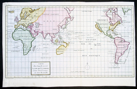
1750 Admiral George Anson & Lattre Large Antique World Map, California Island
-
Title : Carte dans laquelle on Voit la Route que le Centurion a Tenu dans la Voiage au tour du Monde
- Date : 1750
- Condition: (A+) Fine Condition
- Ref: 92607
- Size: 16 1/2in x 11in (420mm x 280mm)
Description:
This finely engraved beautifully hand coloured original antique World Map - showing California as an Island - illustrates the route taken by Admiral George Anson in his ship the Centurion in his global voyage of discovery between 1740 & 1744.
The map was engraved by Frenchman Jean Lattre in 1750 and was published in the French edition of Ansons book A Voyage round the World, in the Years MDCCXL, I, II, III,IV. The book was written by Richard Walter, Chaplin aboard Ansons flagship, Centurion.
In his famous voyage (1740–44) around the world, Anson, in spite of shipwrecks and scurvy, inflicted great damage on Spanish shipping and returned to England with a rich prize. He was raised to the peerage after his popular naval victory (1747) off Cape Finisterre. Appointed then as first lord of the admiralty, he assisted William Pitt, Lord Chatham, in reorganizing naval administration.
British navigators in the 1700`s were often interested in more than increasing the glory of God & Country. In September 1740 Commodore Anson set off across the Atlantic with six poorly manned, ill-equipped vessels to capture Spanish treasure ships in the Pacific. He lost three ships rounding Cape Horn but went on to raid Spanish mining settlements on the coast of Chili. Although he and his crew suffered incredible hardships while crossing the Pacific in their one remaining ship, the Centurion, Anson managed to capture a Spanish treasure galleon near the Philippines. He sold this prize for £400,000 in Canton, China, the Centurion being the first British warship to enter Chinese waters. By the time he reached England in June 1744, more than half the original crew of nearly 2,000 men had died, chiefly of scurvy. (Ref: Tooley)
General Description:
Paper thickness and quality: - Heavy & stable
Paper color: - White
Age of map color: - Early
Colors used: - Yellow, green, pink
General color appearance: - Authentic
Paper size: - 16 1/2in x 11in (420mm x 280mm)
Plate size: - 16 1/2in x 11in (420mm x 280mm)
Margins: - Min 1/2in (12mm)
Imperfections:
Margins: - None
Plate area: - Folds as issued, very light offsetting
Verso: - None